Showing 24 items matching "rock wall construction"
-
 University of Melbourne, Burnley Campus Archives
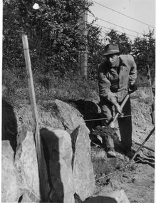
Photograph - Black and white print, E.M. Gibson, Public Works Maintenance Staff Member, 1948
... ...rock wall construction...george phillips jack edwards e. m. gibson collection rock wall construction swan street Black and white photograph of George Phillips and Jack Edwards Public Works Maintenance Staff Member Photograph Black and white print E.M. ...Black and white photograph of George Phillips and Jack Edwardsgeorge phillips, jack edwards, e. m. gibson collection, rock wall construction, swan street -
 University of Melbourne, Burnley Campus Archives
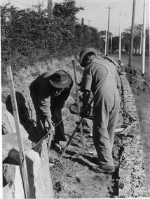
Photograph - Black and white print, Construction of Rock Wall Swan Street, 1948
... Construction of Rock Wall Swan Street......rock wall swan street...construction...george phillips jack edwards e. m. gibson collection rock wall swan street construction 263/16 28 Black and white photograph of George Phillips and Jack Edwards constructing the Rock Wall Swan Street. ...Black and white photograph of George Phillips and Jack Edwards constructing the Rock Wall Swan Street.263/16 28george phillips, jack edwards, e. m. gibson collection, rock wall swan street, construction -
 Kiewa Valley Historical Society
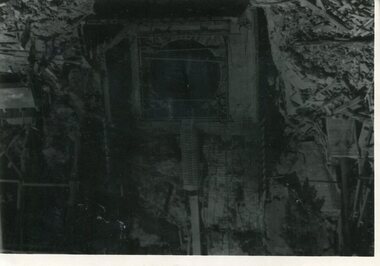
Photo - Junction Dam Diversion Tunnel
... wall. Lake Guy was named after Mr. L.T. Guy who was the Resident engineer, in charge of construction work and associated activities on the Kiewa Area from 1939 to November 1946. Diversion dams are installed to raise the water level of a body of water to be redirected. The redirected water is used for hydro electric power generation. A diversion tunnel is usually bored through solid rock ...Junction (Lake Guy) Dam is a 'slab and buttress' type wall. A timber frame is built and then filled with concrete. The first batch of concrete was placed in September, 1940. By June, 1941 the buttresses were finished to a height safe from floods and in October of that year a flood of 2,800 cusecs occurred but with only slight damage to the installations. Industrial trouble caused some delays but there was also slow progress on the part of the contractor and the work was taken over by the S.E.C., terminating the contract. The dam was completed in March, 1944. A walkway was made through the dam wall. Lake Guy was named after Mr. L.T. Guy who was the Resident engineer, in charge of construction work and associated activities on the Kiewa Area from 1939 to November 1946.Diversion dams are installed to raise the water level of a body of water to be redirected. The redirected water is used for hydro electric power generation. A diversion tunnel is usually bored through solid rock next to the dam site to bypass the dam construction site. The dam is built while the river flows through the diversion tunnel.Photos of the construction of the Junction Dam detail the harsh conditions faced by construction workers, building dams and villages to accommodate workers in the 1940s to the 1950s. Australia at this period in time, experienced a surge of population (influx of World War II refugees), which was the catalyst for developing and undergoing an enormous hydroelectricity program for the Alpine regions, both in Victoria and New South Wales. This program was initiated to supply electricity to the major southern Australian cities of Adelaide, Melbourne and Sydney. It was thought that these developments would reduce, if not eliminate, the requirement for coal driven power stations. However time has demonstrated that these power stations have not matched the demand required by the industries and the populations of the major urban and cities.Black and white photograph of Junction Dam diversion tunnel at Bogong VillageHandwritten on back - Junction Dam Diversional Tunnelbogong, secv, junction dam, lake guy -
 Kiewa Valley Historical Society
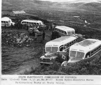
Photograph - Parlimentary Party visiting Rocky Valley Dam site, 15-4-1948
... construction of the Rocky Valley Dam and wall. Work was commenced in early 1947 but had to be suspended during winter and then resumed in October. Work continued in 1948 with the establishment of work facilities and, at the dam site, the river was diverted through a temporary pipeline. Rocky Valley and associated spillway and outlet works were completed in 1959. A pictorial record of the construction of the rock ...This photograph was taken during construction of the Rocky Valley Dam and wall. Work was commenced in early 1947 but had to be suspended during winter and then resumed in October. Work continued in 1948 with the establishment of work facilities and, at the dam site, the river was diverted through a temporary pipeline. Rocky Valley and associated spillway and outlet works were completed in 1959.A pictorial record of the construction of the rock and earth filled dam wall at Rocky Valley. Shows the extent of the project undertaken and the level of importance of the project as indicated by the large representation at the parliamentary party visit on 15/4/48.Photocopy of black and white photograph of parliamentary party visiting Rocky Valley Dam site 15/04/1948Typed on the bottom of photocopy - State Electricity Commission of Victoria. Date: 15-4-48 Time: 4.30pm No: K4397. Kiewa Hydro-Electric works. Parlimentary Party at Rocky Valleyrocky valley dam, parliamentary party, secv -
 Kiewa Valley Historical Society
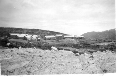
11 Black and White photographs of the Rocky Valley area, c1948
... construction of a stream diversion was commenced to allow excavation to commence for the dam wall. In the summer of 1948/49, stripping of the foundation area on both sides of the river was carried out. Weather conditions were not always favourable during the construction, particularly 1955/56 summer, and work would have to cease each year for the winter season due to the severe conditions. The dam is a earth and rock...construction of a stream diversion was commenced to allow excavation to commence for the dam wall. In the summer of 1948/49, stripping of the foundation area on both sides of the river was carried out. Weather conditions were not always favourable during the construction, particularly 1955/56 summer, and work would have to cease each year for the winter season due to the severe conditions. The dam is a earth and rock ...In October 1947 construction was commenced on the erection of the workmen's camp at Rocky Valley. Also in 1947 construction of a stream diversion was commenced to allow excavation to commence for the dam wall. In the summer of 1948/49, stripping of the foundation area on both sides of the river was carried out. Weather conditions were not always favourable during the construction, particularly 1955/56 summer, and work would have to cease each year for the winter season due to the severe conditions. The dam is a earth and rock fill structure with a height of about 30.5 metres and crest length 518.16 metres and was completed in March, 1959.These photographs show the type of terrain in the area prior to the construction and filling of Rocky Valley Dam. Also of interest is the type of accommodation provided for those working on the construction and the early cranes available in the 1940/50's. Of historical importance to understand the conditions in the early construction of the Kiewa Hydro Electric SchemeEleven small black and white photographsPhoto No. 1 - on the back, printed in ink"Rocky Valley - New Mess & offices Dec. 1948". In pencil '14 on the back Photo No. 2 - on the back, printed in ink "Rocky Valley Camp. October 1948". Also stamped on the back "998L" Photo No. 3 -on the back, printed in ink "Rocky Valley Hostel October 1948". Also stamped on the back '998L' Photo No. 4 - on the back, printed in ink "Spion Kopje from bedroom window. October 1948". Stamped on the back '998L'. Photo No. 5 - on the back, printed in ink "Rocky Valley Basin Dec. 1948." In pencil on back, 14. Photo No. 6 - on the back, printed in ink "Site of Wall for Rocky Valley Dam Dec. 1948". In pencil on back, 14. Photo No. 7 - On the back, printed in ink "Commencing of Diversion Tunnel Rocky Valley December 1948". In pencil on back, 14. Photo No. 8 - on the back, printed in ink "One of the two electric cranes at Rocky Valley December 1948". In pencil on back, 14. Photo No. 9 - on the back, printed in ink "'Rapier' (H.Y.) electric crane Rocky Valley December 1948". In pencil on back, 14 . Photo No. 10 - on the back, printed in ink " Pretty Valley Pump line construction Mt. Cope in Background Nov 1948. Circular stamp with the words 'print by Wilson White Albury' in the circle. Photo No. 11 - on the back, printed in ink "Stringing cable on Ruined Castle October 1948. Same stamp as No. 10. In pencil '31'. rocky valley; pretty valley; ruined castle; bogong high plains; kiewa hydro electric scheme -
 Kiewa Valley Historical Society
12 small black and white photgraphs of Junction Dam and surrounding area, Photo No. 1 c1940, all others c 1948
... Construction Company. Stiff leg derricks were erected at appropriate locations at the site of the dam and used for the disposal of excavated material and the placing of concrete. A rock crushing and screening plant was established at a site a short distance upstream from the dam site and concrete was supplied from a central mixing plant placed close to the upstream toe of the structure. The SEC took over the construction in April 1942 and the dam wall...Construction Company. Stiff leg derricks were erected at appropriate locations at the site of the dam and used for the disposal of excavated material and the placing of concrete. A rock crushing and screening plant was established at a site a short distance upstream from the dam site and concrete was supplied from a central mixing plant placed close to the upstream toe of the structure. The SEC took over the construction in April 1942 and the dam wall ...Junction Dam is a reinforced slab and buttress type construction and was commenced in February, 1940 by Lewis Construction Company. Stiff leg derricks were erected at appropriate locations at the site of the dam and used for the disposal of excavated material and the placing of concrete. A rock crushing and screening plant was established at a site a short distance upstream from the dam site and concrete was supplied from a central mixing plant placed close to the upstream toe of the structure. The SEC took over the construction in April 1942 and the dam wall was completed in March, 1944. Bogong township was commenced in early 1940 with the construction of a workmen's camp housing 96 men, (known as Junction camp). Construction of housing for families commenced shortly after. Forty houses, plus office, workshops, stores and laboratory accommodation were completed over the next 5 years,Of historical significance as a pictorial record of Junction Dam, Lake Guy and Bogong Village, as the photos were taken only 4 years after completion and one photo taken on completion of the dam wall but before the lake was filled with water.12 small black and white photographs of Junction Dam, Bogong Village and surrounding area.Photo 1 - On the back upper edge in pen 'Junction Dam'. Then '12' in pencil, circular stamp, printed in centre 'Print by Willson White Albury'. Photo 2 - On the back upper edge in pen 'Junction Dam October 1948'. Stamp as no. 1 photo. Stamp '998L' lower centre. Photo 3 - on the back upper edge in pen 'Junction Dam October 1948'. Circular stamp with 'Kodak Print' . Lower centre back is stamped 'velox' and '998L'. Photo 4 - upper back, in ink - 'Junction Dam Spion Kopje in background. October 1948'. Stamps as photo no. 4. Photo 5 - upper back, in ink - 'Lake Guy (orange filter) October 1948'. Centre back, in pencil '29' and circular stamp with words 'Print by Willson White Albury'. Photo 6 - upper back edge 'Junction, Bogong from Radio Receiving Shack Dec. 1948'. In pencil '14'. Photo 7 - On back of photo 'View of Mountains from Little Arthur Fire Track October 1948'. Two circular stamps with 'Kodak Print', another two stamps - 'Velox' and '998L'. Photo 8 - On back in ink 'Loone's Store Bogong with Spion Kopje in background. October 1948'. Lower down, stamps 'Velox' and '998L'. Part of circular stamp with one word 'Kodak'. Photo 9 - on back in ink 'Junction Camp, Bogong Village & Lake Guy from Little Arthur Fire Track. October 1948'. Stamped across writing '998L'. Lower down stamped 'Velox' and circular stamp with words 'Kodak Print'. Photo 10 - on back in ink 'Junction Camp & Bogong Village Lake Guy in Foreground. October 1948'. Stamps as photo 9. Photo 11 - on back in ink 'Junction Camp & Bogong Village, Lake Guy in Foreground. October 1948'. Lower stamp '998L'. Photo 12 - 'Junction of Rocky & Pretty Rivers with tennis courts in foreground October 1948' . Circular stamp with words, 'Print by Willson White Albury'. Number '29' written pencil.junction dam; bogong village; kiewa hydro electric scheme; lake guy -
 Kiewa Valley Historical Society
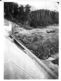
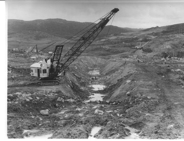
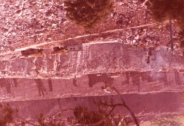
Photograph Rocky Valley Dam Excavations, Rocky Valley Dam Wall Excavation, c1947-48
... Work proceeded in the summer months with the placing of concrete in the foundations and earth and rock fill for the construction of the wall. Rocky Valley and associated spillway and outlet works were completed in March, 1959. ...Work proceeded in the summer months with the placing of concrete in the foundations and earth and rock fill for the construction of the wall. Rocky Valley and associated spillway and outlet works were completed in March, 1959. ...Work commenced at Rocky Valley Dam site in early 1947 and proceeded until May. Resumed work in October after the winter and a camp for the accommodation of workmen was commenced at this time. Work continued in 1948 with the establishment of work facilities, including the erection of two large excavators. At the dam site the river was diverted through a temporary pipeline. Work proceeded in the summer months with the placing of concrete in the foundations and earth and rock fill for the construction of the wall. Rocky Valley and associated spillway and outlet works were completed in March, 1959. A very good representation of the type of machinery available in the 1940's used for excavation of the dam and the construction of the dam wall.Black and white photograph of Rocky Valley Dam wall under construction. There are at least three cranes plus workmen in the photo. This is taken from the Heathey's Spur side of the dam wall looking back toward Sun Valley.Hand written on back of photograph "Rocky Valley Dam Wall Excavation" in blue ink.rocky valley, dam, wall, machinery -
 Kiewa Valley Historical Society
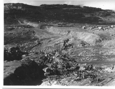
Photograph of Rocky Valley, Rocky Valley showing Dam Excavation, c1948-1951
... construction of the Rocky Valley Dam and wall. Work was commenced in early 1947 but had to be suspended during winter and then resumed in October. Work continued in 1948 with the establishment of work facilities and, at the dam site, the river was diverted through a temporary pipeline. Rocky Valley and associated spillway and outlet works were completed in 1959. A pictorial record of the construction of the rock ...This photograph was taken during construction of the Rocky Valley Dam and wall. Work was commenced in early 1947 but had to be suspended during winter and then resumed in October. Work continued in 1948 with the establishment of work facilities and, at the dam site, the river was diverted through a temporary pipeline. Rocky Valley and associated spillway and outlet works were completed in 1959.A pictorial record of the construction of the rock and earth filled dam wall at Rocky Valley. Shows the extent of the project undertaken and the fact that a lot of the work was done manually by pick and shovel - note the workmen using picks and sledge hammers on the lower half of the photo.A black and white photograph showing the excavation of the dam at Rocky Valley looking towards Heathey's SpurHand written on the back of photograph in blue ink "Rocky Valley showing dam excavation" rocky valley, dam, wall, picks, sledge hammers -
 Kiewa Valley Historical Society
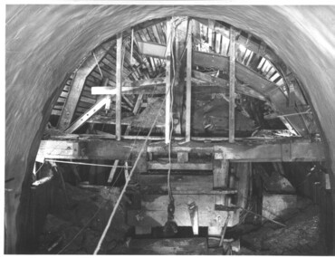
Photograph during construction of West Kiewa tunnel, 'Timbering in West Kiewa Tunnel', c1947
... walls before lining with concrete. No solid rock was found and the tunneling proceeded through decomposed boulders, gravel and clay, hence the necessity for support and concreting. west kiewa tailrace tunnel Timbering in West Kiewa Tunnel Black and white photograph showing the timber support, prior to lining with concrete, in the West Kiewa tunnel. 'Timbering in West Kiewa Tunnel' Photograph during construction ...The West Kiewa Tunnel (tailrace tunnel) was commenced from both ends in 1947. Very difficult conditions were encountered in the driving of this tunnel and this meant the immediate provision of support and later the lining of the tunnel with concrete. Work proceeded steadily and the breakthrough of the two headings occurred on 22nd July, 1950.This historical photograph shows in detail the amount of work necessary to stabilise and support the tunnel walls before lining with concrete. No solid rock was found and the tunneling proceeded through decomposed boulders, gravel and clay, hence the necessity for support and concreting. Black and white photograph showing the timber support, prior to lining with concrete, in the West Kiewa tunnel.Timbering in West Kiewa Tunnelwest kiewa, tailrace, tunnel -
 Bendigo Historical Society Inc.
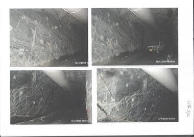
Photograph - Kangaroo Flat Gold Mine Collection: underground in Swan Decline, Kangaroo Flat Gold Mine, 2000
... construction. Eleven images on 3 pages, dated 16/4/2000 (10 a.m.) show decline walls, rock bolts and markout of tunnel shape. ...construction. Eleven images on 3 pages, dated 16/4/2000 (10 a.m.) show decline walls, rock bolts and markout of tunnel shape. ...The modern mine is accessed via the Swan Decline, which commences at the Kangaroo Flat site on the southern outskirts of Bendigo and progresses in a north easterly direction between the Deborah and Sheepshead anticlines, reaching a depth of almost 1000 m below the City of Bendigo. Development of this decline commenced in 1998. Swan Decline closed and history preserved In a major rehabilitation milestone at Kangaroo Flat, the Swan Decline Bendigo’s primary gateway to underground mining, was permanently closed in December 2022. Important parts of Bendigo’s gold rush history were also preserved from the onsite office buildings with 19 boxes of records, and 1350 old photos being scanned and provided to the local historical societies and the Goldfields Library Corporation. A volunteer from the Bendigo Historical Society, Kay MacGregor, also scanned approximately 40 bookshelves of newspaper clippings to assist with recording and preserving geological drilling locations.Black and white photocopies of photographs of Swan Decline, showing some stages of underground construction. Eleven images on 3 pages, dated 16/4/2000 (10 a.m.) show decline walls, rock bolts and markout of tunnel shape. One image shows a utility in the tunnel. Final three images on one page, have notations on the photos: 'opposite SP18 LHS decline', 'just up from previous 3 box positions' and 'just up from tank, same side' On bottom RH side 'spots for scale attention, IT required, all lower decline.' All three images dated 12/6/2000.goldmining, kangaroo flat gold mine, western mining corporation, unity mining, swan decline -
 Glenelg Shire Council Cultural Collection
Photograph - Contact Prints - Harbour Construction, n.d
... Glenelg Shire Council Cultural Collection History House Cliff Street Portland great-ocean-road Port of Portland Authority Archives Port of Portland Archives Sheet of 10 black and white contact prints; 2 of a light coloured panel van, one of 2 men in front of a truck, with Clarrie Scott contractor on door, 2 of a bucket from a crane, 1 of tip truck and crane; 3 with dredging pipe, 1 of 2 men standing in front of rock wall Photograph Contact Prints - Harbour Construction ...Port of Portland Authority Archivesport of portland archives -
Glenelg Shire Council Cultural Collection
Photograph - Photograph - Main Breakwater construction, Portland, Feb-54
... construction. Two men standing seaward end. A pole with 2-wheel / cart beside it in centre. Rock wall...construction. Two men standing seaward end. A pole with 2-wheel / cart beside it in centre. Rock wall ...Port of Portland Authority ArchivesBack: Purple PHT Stamp Print No. 227 Date taken 3-2-54 Subject Main Breakwater from Battery Pointport of portland archives, main breakwater, construction, battery point, harbour development -
Glenelg Shire Council Cultural Collection
Photograph - Photograph - Main Breakwater construction, Portland, n.d
... Glenelg Shire Council Cultural Collection History House Cliff Street Portland great-ocean-road Port of Portland Authority Archives Port of Portland Archives main breakwater construction Portland Harbour harbour development Back: 11 - blue biro Border ruled in pencil Portland "Guardian" - purple stamp Black &white photo of two young girls, wearing pleated skirts & jumpers, standing in front of boulders forming part of the rock wall, east side main breakwater. ...Port of Portland Authority ArchivesBack: 11 - blue biro Border ruled in pencil Portland "Guardian" - purple stampport of portland archives, main breakwater, construction, portland harbour, harbour development -
Glenelg Shire Council Cultural Collection
Photograph - Photograph - Main Breakwater construction, Portland, n.d
... Black and white photo, Main Breakwater construction. Looking towards Battery Point. Rock wall on right. Large crane dropping boulders into water. ...Glenelg Shire Council Cultural Collection History House Cliff Street Portland great-ocean-road Port of Portland Authority Archives Port of Portland Archives main breakwater construction harbour development Black and white photo, Main Breakwater construction. Looking towards Battery Point. Rock wall on right. Large crane dropping boulders into water. ...Port of Portland Authority Archivesport of portland archives, main breakwater, construction, harbour development -
Glenelg Shire Council Cultural Collection
Photograph - Photograph - Main Breakwater construction, Portland, n.d
... Glenelg Shire Council Cultural Collection History House Cliff Street Portland great-ocean-road Port of Portland Authority Archives Port of Portland Archives harbour construction main breakwater harbour development Black and white photo of rock wall, looking north west. ...Port of Portland Authority Archivesport of portland archives, harbour construction, main breakwater, harbour development -
Glenelg Shire Council Cultural Collection
Photograph - Photograph - Main Breakwater construction, Portland, Mar-54
... construction. One man standing seaward end. a pole with 2-wheel / cart beside it in centre. Rock wall...construction. One man standing seaward end. a pole with 2-wheel / cart beside it in centre. Rock wall ...Port of Portland Authority ArchivesBack: Purple PHT Stamp - Print No - 4/34 Neg. No. 231 Date taken 2.3.54 Subject Main Breakwater from Battery Pointport of portland archives, battery point, main breakwater, construction, harbour, portland -
Glenelg Shire Council Cultural Collection
Photograph - Photograph - Main Breakwater Construction, n.d
... construction. Section of concreting next to rubble wall. Number 1850 painted onto a rock. ...construction. Section of concreting next to rubble wall. Number 1850 painted onto a rock. ...Port of Portland Authority Archivesport of portland archives -
Tatura Irrigation & Wartime Camps Museum
Photograph, 24/3/1917
... Sugarloaf Reservoir construction of core wall and tower / Rail trucks on single line bottom centre / Traction engine and pump in timber shed lower right / Horses and carts on bank beside upper dams/ words printed:"Upper Dam Core Wall , Bed Rock, Lower Dam."...Sugarloaf Reservoir construction of core wall and tower / Rail trucks on single line bottom centre / Traction engine and pump in timber shed lower right / Horses and carts on bank beside upper dams/ words printed:"Upper Dam Core Wall , Bed Rock, Lower Dam." ...Taken by photographer for State Rivers and Water Supply Commission.Medium sized black and white photograph. Sugarloaf Reservoir construction of core wall and tower / Rail trucks on single line bottom centre / Traction engine and pump in timber shed lower right / Horses and carts on bank beside upper dams/ words printed:"Upper Dam Core Wall , Bed Rock, Lower Dam."victorian state rivers and supply commission, sugarloaf reservoir -
Tatura Irrigation & Wartime Camps Museum
Photograph, 1936
... Eildon Reservoir overall picture - Original reservoir and dam / rock and earth fill dam wall and construction huts left of centre / trees foreground / tree covered hills top left and across top / dam water / with leisure craft near wall....Eildon Reservoir overall picture - Original reservoir and dam / rock and earth fill dam wall and construction huts left of centre / trees foreground / tree covered hills top left and across top / dam water / with leisure craft near wall. ...Photo taken by the photographer for Victoria State Rivers and Water Supply CommissionMedium sized black and white photograph. Eildon Reservoir overall picture - Original reservoir and dam / rock and earth fill dam wall and construction huts left of centre / trees foreground / tree covered hills top left and across top / dam water / with leisure craft near wall.goulburn, irrigation, photo, victoria state rivers and water supply commission, eildon, eildon weir -
 Stawell Historical Society Inc
Slide, Ian McCann, Side of Lake Bellfield, 1965
... Colour Slide. show the rock wall of Lake Bellfield and the roadway usied in construction...Stawell Historical Society Inc 46 Longfield St Stawell grampians Lake Bellfield Colour Slide. show the rock wall of Lake Bellfield and the roadway usied in construction Side of Lake Bellfield Slide Ian McCann ...Colour Slide. show the rock wall of Lake Bellfield and the roadway usied in constructionlake bellfield -
 Federation University Historical Collection
Book - Class Notes, A History of Architecture Grade I by R.D. Fraser, 1948, 1948
... Topics include: Egyptian Architecture, Greek Architecture (BC300-BC700), Etruscan Architecture (BC750-BC100) and Roman Architecture (BC146-BC365) Early Christian Architecture Images include: Egypt, Great Pyramids, rock cut tombs, catacombs, Egyptian Temples, Development of a Pyramid, Egyptian Construction Methods, Greece, Greek Temples, Sloping Roofs, Doric Temples, Temple of Poseidon, Parthenon, arches, Acropolis Athens, Partenon, Ionic Volute, Propylaea, Erechtheion Athens, Corinthian examples, Greek Theatre, Optical Corrections in Architecture, The Greek House, Temple of Fortuna Virilis Rome, Maison Caree Nimes, Roman Circular Temples, Basilica of Trajan, Column of Trajan, Colosseum Rome, Basilica of Constantine, Roman Arched Structures, Romas Thermae at Romes, Arch and Wall construction, columns, mouldings Clemente Rome, S. ...Topics include: Egyptian Architecture, Greek Architecture (BC300-BC700), Etruscan Architecture (BC750-BC100) and Roman Architecture (BC146-BC365) Early Christian Architecture Images include: Egypt, Great Pyramids, rock cut tombs, catacombs, Egyptian Temples, Development of a Pyramid, Egyptian Construction Methods, Greece, Greek Temples, Sloping Roofs, Doric Temples, Temple of Poseidon, Parthenon, arches, Acropolis Athens, Partenon, Ionic Volute, Propylaea, Erechtheion Athens, Corinthian examples, Greek Theatre, Optical Corrections in Architecture, The Greek House, Temple of Fortuna Virilis Rome, Maison Caree Nimes, Roman Circular Temples, Basilica of Trajan, Column of Trajan, Colosseum Rome, Basilica of Constantine, Roman Arched Structures, Romas Thermae at Romes, Arch and Wall construction, columns, mouldings Clemente Rome, S. ...R.D. Fraser was a student of the Ballarat Technical Art School, a division of the Ballarat School of Mines. Numerous hand written and hand drawn class notes from from the Ballarat Technical Art School. Topics include: Egyptian Architecture, Greek Architecture (BC300-BC700), Etruscan Architecture (BC750-BC100) and Roman Architecture (BC146-BC365) Early Christian Architecture Images include: Egypt, Great Pyramids, rock cut tombs, catacombs, Egyptian Temples, Development of a Pyramid, Egyptian Construction Methods, Greece, Greek Temples, Sloping Roofs, Doric Temples, Temple of Poseidon, Parthenon, arches, Acropolis Athens, Partenon, Ionic Volute, Propylaea, Erechtheion Athens, Corinthian examples, Greek Theatre, Optical Corrections in Architecture, The Greek House, Temple of Fortuna Virilis Rome, Maison Caree Nimes, Roman Circular Temples, Basilica of Trajan, Column of Trajan, Colosseum Rome, Basilica of Constantine, Roman Arched Structures, Romas Thermae at Romes, Arch and Wall construction, columns, mouldings Clemente Rome, S. Paolo Fuori le Mura Rome, Baptistery of Constantine Rome, S. Constanza Romearchitecture, art history, ballarat technical art school, r.d. fraser, alumni -
 University of Melbourne, Burnley Campus Archives
Photograph - Black and white print, E.M. Gibson, Construction of Rock Wall Swan Street, 1948
... Construction of Rock Wall Swan Street...rock wall swan street public works maintenance staff george phillips jack edwards e. m. gibson collection Black and white photograph of one of the Public Works maintenace staff who constructed the Rock Wall in Swan Street. George Phillips or Jack Edwards. Construction ...Black and white photograph of one of the Public Works maintenace staff who constructed the Rock Wall in Swan Street. George Phillips or Jack Edwards.rock wall, swan street, public works, maintenance, staff, george phillips, jack edwards, e. m. gibson collection -
 Flagstaff Hill Maritime Museum and Village
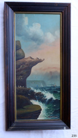
Painting - Oil painting, W. Langley-Taylor, Eagle Rock, Warrnambool, Vic, Late 19th to early 20th century
... Historically, the painting is significant as an example of the late nineteenth- and early twentieth-century methods and materials used in frame construction. flagstaff hill warrnambool shipwrecked coast flagstaff hill maritime museum maritime museum shipwreck coast flagstaff hill maritime village great ocean road eagle rock warrnambool w. langley-taylor oil painting wall decoration seascape of victoria's coast mrs m irby art seascape pair of paintings Painted on front “W.LANGLEY-TAYLOR.” and “EAGLE ROCK, WARRNAMBOOL, VIC.” ...This painting is one of a pair of large works by W. Langley-Taylor in our collection. Further information about the artist has not yet been identified. The pair depicts coastal sites on either side of Port Phillip Bay, south of Melbourne. This work represents Eagle Rock, Warrnambool, on the bay’s western side. Eagle Rock lies about 400 metres west of Thunder Point, near Shelly Beach. The painting shows the cliff formations looking east towards the Warrnambool Breakwater. The site is well known locally, appears in many photographs, and is also a recognised dive location in calm conditions. This stretch of Warrnambool coastline is exposed to the Southern Ocean. In the painting, the breaking waves and northerly drift of smoke from the steamship suggest a strong southerly wind. THE INSCRIPTIONS “Mrs M Irby” and “980/Regency”:- The significance of the inscription “Mrs M Irby”, which appears on the reverse of both paintings, has not been determined. It may refer to the ship or shipping company Irby. Irby was a four-masted iron ship built in Liverpool in 1881. It later traded between London and Australia, including visits to Melbourne and Hobart, before being destroyed by a mine in 1919 while en route to England. Alternatively, “Mrs M Irby” and the pencil inscription “980/Regency” may refer to a delivery address, perhaps an apartment or hotel. This painting is geographically significant for its depiction of Victoria’s coastal scenery. It is also significant as one of a pair of seascapes depicting sites on either side of Port Phillip Bay. Historically, the painting is significant as an example of the late nineteenth- and early twentieth-century methods and materials used in frame construction.Painting oil on board in a dark wooden frame, portrait orientation. Seascape of rock formation and cliffs, two yachts, a two-masted steamboat with red funnel and smoke, flying birds, high waves breaking onto rocks, blue sky with clouds, some tinted pink. The title is painted on the lower left corner, and the artist, W. Langley-Taylor, has signed his name on the lower right. The inscription on the back is handwritten script in red crayon or thick red pencil. The board is held in place inside the timber frame with small, dark metal tacks around all sides. Metal eyes join the wire to the frame. Small, round, dark metal nail heads are dispersed around the frame, and there is a change of colour on both the board and the wood of the frame. Painted on front “W.LANGLEY-TAYLOR.” and “EAGLE ROCK, WARRNAMBOOL, VIC.” Handwritten on back “Mrs. M. Irby” and “980 [underlined] Regency”flagstaff hill, warrnambool, shipwrecked coast, flagstaff hill maritime museum, maritime museum, shipwreck coast, flagstaff hill maritime village, great ocean road, eagle rock warrnambool, w. langley-taylor, oil painting, wall decoration, seascape of victoria's coast, mrs m irby, art, seascape, pair of paintings -
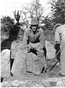
 Port Melbourne Historical & Preservation Society
Photograph - Construction of rock wall at George Samuel Walter Memorial Garden, Jack GOULD, C. 1950-55
... Construction of rock wall at George Samuel Walter Memorial Garden...A worker is bent over on the edge of George Samuel Walter Memorial Garden next to a pile of rocks beginning the construction of the rock wall....A worker is bent over on the edge of George Samuel Walter Memorial Garden next to a pile of rocks beginning the construction of the rock wall. Photograph Construction of rock wall at George Samuel Walter Memorial Garden Jack GOULD ...From a box of photographs in Nancy U'REN's papers used during research for her thesis, The Early Growth and Development of Sandridge (1976) and/or her book with Noel TURNBULL, A History of Port Melbourne (1983). Black and white photograph showing Crockford Street as it turns into Bay Street. A worker is bent over on the edge of George Samuel Walter Memorial Garden next to a pile of rocks beginning the construction of the rock wall.bay street, crockford street, port melbourne town hall, george samuel walter memorial garden, nancy u'ren nee morris