Showing 98 items matching "rood"
-
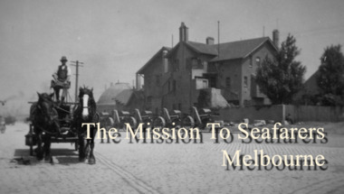
 Mission to Seafarers Victoria
Audio - Oral history, Sarah Rood (from Way Back When), Nigel Porteous, 22 February 2016
... Interviews of Nigel Porteous made by Sarah Rood from Way Back When Consulting in the Mission to Seafarers for the Early Origins exhibition in 2016...Sarah Rood (from Way Back When)...Part of the permanent exhibition "Early Origins" curated by Georgia Melville. early origins 2016 sarah rood way back when oral history interview mission to seafarers seamen's mission nigel porteous Interviews of Nigel Porteous made by Sarah Rood from Way Back When Consulting in the Mission to Seafarers for the Early Origins exhibition in 2016 Nigel Porteous Audio Oral history Sarah Rood (from Way Back When) Way Back When Nigel Porteous ...Nigel Porteous, Chairman in 2016, talks about their experience at the Mission.Part of the permanent exhibition "Early Origins" curated by Georgia Melville.Interviews of Nigel Porteous made by Sarah Rood from Way Back When Consulting in the Mission to Seafarers for the Early Origins exhibition in 2016early origins, 2016, sarah rood, way back when, oral history, interview, mission to seafarers, seamen's mission, nigel porteous -
Mission to Seafarers Victoria
Audio - Oral history, Sarah Rood (from Way Back When), Ivor Forsyth Grant, 22 February 2016
... Interviews of Ivor Forsyth made by Sarah Rood from Way Back When Consulting in the Mission to Seafarers for the Early Origins exhibition in 2016...Sarah Rood (from Way Back When)...Part of the permanent exhibition "Early Origins" curated by Georgia Melville. early origins 2016 sarah rood way back when oral history interview mission to seafarers seamen's mission ivor forsyth grant Interviews of Ivor Forsyth made by Sarah Rood from Way Back When Consulting in the Mission to Seafarers for the Early Origins exhibition in 2016 Ivor Forsyth Grant Audio Oral history Sarah Rood (from Way Back When) Way Back When Ivor Forsyth Grant ...Ivor Forsyth Grant talks about his experience at the Mission.Part of the permanent exhibition "Early Origins" curated by Georgia Melville.Interviews of Ivor Forsyth made by Sarah Rood from Way Back When Consulting in the Mission to Seafarers for the Early Origins exhibition in 2016early origins, 2016, sarah rood, way back when, oral history, interview, mission to seafarers, seamen's mission, ivor forsyth grant -
Mission to Seafarers Victoria
Audio - Oral history, Sarah Rood (from Way Back When), Alan Knott, 22 February 2016
... Interviews of Alan Knott made by Sarah Rood from Way Back When Consulting in the Mission to Seafarers for the Early Origins exhibition in 2016...Sarah Rood (from Way Back When)...Part of the permanent exhibition "Early Origins" curated by Georgia Melville. early origins 2016 sarah rood way back when oral history interview mission to seafarers seamen's mission alan knott Interviews of Alan Knott made by Sarah Rood from Way Back When Consulting in the Mission to Seafarers for the Early Origins exhibition in 2016 Alan Knott Audio Oral history Sarah Rood (from Way Back When) Way Back When Alan Knott ...Alan Knott talks about their experience at the Mission.Part of the permanent exhibition "Early Origins" curated by Georgia Melville.Interviews of Alan Knott made by Sarah Rood from Way Back When Consulting in the Mission to Seafarers for the Early Origins exhibition in 2016early origins, 2016, sarah rood, way back when, oral history, interview, mission to seafarers, seamen's mission, alan knott -
Mission to Seafarers Victoria
Audio - Oral history, Sarah Rood (from Way Back When), David Conolly, 28 Januray 2016
... Interviews of David Conolly made by Sarah Rood from Way Back When Consulting in the Mission to Seafarers for the Early Origins exhibition in 2016...Sarah Rood (from Way Back When)...Part of the permanent exhibition "Early Origins" curated by Georgia Melville. early origins 2016 sarah rood way back when oral history interview mission to seafarers seamen's mission david conolly lay reader Interviews of David Conolly made by Sarah Rood from Way Back When Consulting in the Mission to Seafarers for the Early Origins exhibition in 2016 David Conolly Audio Oral history Sarah Rood (from Way Back When) Way Back When David Conolly ...David Conolly talks about his time as lay reader at the Mission in the 1950s.Part of the permanent exhibition "Early Origins" curated by Georgia Melville.Interviews of David Conolly made by Sarah Rood from Way Back When Consulting in the Mission to Seafarers for the Early Origins exhibition in 2016early origins, 2016, sarah rood, way back when, oral history, interview, mission to seafarers, seamen's mission, david conolly, lay reader -
Mission to Seafarers Victoria
Audio - Oral history, Sarah Rood (from Way Back When), Andrea Fleming, 28 January 2016
... Interviews of Andrea Fleming made by Sarah Rood from Way Back When Consulting in the Mission to Seafarers for the Early Origins exhibition in 2016...Sarah Rood (from Way Back When)...She was succeeded by Sue Dight Part of the permanent exhibition "Early Origins" curated by Georgia Melville. early origins 2016 sarah rood way back when oral history interview mission to seafarers seamen's mission andrea fleming Interviews of Andrea Fleming made by Sarah Rood from Way Back When Consulting in the Mission to Seafarers for the Early Origins exhibition in 2016 Andrea Fleming Audio Oral history Sarah Rood (from Way Back When) Way Back When Andrea Fleming ...Andrea Fleming talks about the Mission and its role.Andrea Fleming was CEO of the Mission between 2004 and May 2017. She was succeeded by Sue DightPart of the permanent exhibition "Early Origins" curated by Georgia Melville.Interviews of Andrea Fleming made by Sarah Rood from Way Back When Consulting in the Mission to Seafarers for the Early Origins exhibition in 2016early origins, 2016, sarah rood, way back when, oral history, interview, mission to seafarers, seamen's mission, andrea fleming -
University of Melbourne, Burnley Campus Archives
Newspaper - Newspaper Cutting, The Age, University May Axe Regional Campuses, 01.10.2004
... Copy of article in The Age 01.10.2004 by David Rood, Higher Education Reporter. Report on a memo from The Dean of the Faculty of Land and Food Resources, The University of Melbourne, some regional campuses may be amalgamated or closed.......David Rood...University May Axe Regional Campuses Newspaper Newspaper Cutting The Age David Rood ...university of melbourne, regional campuses, faculty of land and food resources, memo, dean faculty of land and food resources, country campuses, closure of campuses -
University of Melbourne, Burnley Campus Archives
Newspaper - Newspaper Cutting, The Age, Kosky Plan to Strip Melbourne of Places, 16.10.2004
... Copy of article in The Age 16.10.2004, p 3 by David Rood, Higher Education reporter. Report on Victorian Education Minister, Lynne Kosky, stating that the State Government would not allow The University of Melbourne's proposal to close down regional campuses.......David Rood...Kosky Plan to Strip Melbourne of Places Newspaper Newspaper Cutting The Age David Rood ...regional campuses, lynne kosky, victorian education minister, victorian state government, university of melbourne, closure of campuses, country campuses -
 Mission to Seafarers Victoria
Film - Interview, Sarah Rood (from Way Back When), In Conversation with David Conolly and Nigel Porteous, 28 January 2016
... Sarah Rood (from Way Back When)...Part of the permanent exhibition "Early Origins" curated by Georgia Melville. early origins 2016 sarah rood david conolly way back when oral history interview mission to seafarers lay reader seamen's mission nigel porteous Interviews filmed in the Mission to Seafarers for the Early Origins exhibition in 2016 In Conversation with David Conolly and Nigel Porteous Film Interview Sarah Rood (from Way Back When) David Conolly Way Back When William Butler ...David Conolly, former lay reader in the 1950s and Nigel Porteous, Chairman in 2016, talk about their experience at the Mission. The movie uses images from the collection and images from the 1952 film.Part of the permanent exhibition "Early Origins" curated by Georgia Melville.Interviews filmed in the Mission to Seafarers for the Early Origins exhibition in 2016early origins, 2016, sarah rood, david conolly, way back when, oral history, interview, mission to seafarers, lay reader, seamen's mission, nigel porteous -
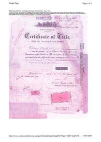
Whitehorse Historical Society Inc.
Legal record - Land Title, Moffatt land, 1925
... 2 acres 2 roods and 13 perches, bakers Road Blackburn, from William James Moffatt to Edith Sarah Moffatt, 6 September 1946 and Arthur Vernon Moffatt 6 September 1946....Certificate of Title Vol.5039 Fol. 703 29 September 1925, 2 acres 2 roods and 13 perches, bakers Road Blackburn, from William James Moffatt to Edith Sarah Moffatt, 6 September 1946 and Arthur Vernon Moffatt 6 September 1946...Whitehorse Historical Society Inc. 2-10 Deep Creek Road Mitcham melbourne 2 acres 2 roods and 13 perches, bakers Road Blackburn, from William James Moffatt to Edith Sarah Moffatt, 6 September 1946 and Arthur Vernon Moffatt 6 September 1946. ...Certificate of Title Vol.5039 Fol. 703 29 September 1925.Certificate of Title Vol.5039 Fol. 703 29 September 1925, 2 acres 2 roods and 13 perches, bakers Road Blackburn, from William James Moffatt to Edith Sarah Moffatt, 6 September 1946 and Arthur Vernon Moffatt 6 September 1946Certificate of Title Vol.5039 Fol. 703 29 September 1925.moffatt, william james, moffatt, edith sarah, moffatt, arthur vernon, bakers road blackburn -
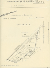 Ringwood and District Historical Society
Map, Department of Mines, Plan of area applied for under the mining leases regulations in the township of Ringwood between Maroondah Highway and Mt. Dandenong Road. Mining District of Castlemaine, County of Mornington, Parish of Ringwood T Area 58(A) 2 (R)15(P) Acres, Roods, Perches. 1934, 20-Feb-34
... Dandenong Road. the area applied for on lease No.8210 by E.G.Browne.Mining District of Castlemaine, County of Mornington, Parish of Ringwood T Area 58(A) 2 (R)15(P) Acres, Roods, Perches....Mining District of Castlemaine, County of Mornington, Parish of Ringwood T Area 58(A) 2 (R)15(P) Acres, Roods, Perches +Additional Keywords: Browne E.G....Mining District of Castlemaine, County of Mornington, Parish of Ringwood T Area 58(A) 2 (R)15(P) Acres, Roods, Perches +Additional Keywords: Browne E.G. ...Map of the township of Ringwood with subdivisions between Maroondah Highway and Mt. Dandenong Road. the area applied for on lease No.8210 by E.G.Browne.Mining District of Castlemaine, County of Mornington, Parish of Ringwood T Area 58(A) 2 (R)15(P) Acres, Roods, Perches.Buff coloured sheet foolscap with black printing showing map of the township of Ringwood between Maroondah Highway and Mt. Dandenong Road. Mining District of Castlemaine, County of Mornington, Parish of Ringwood T Area 58(A) 2 (R)15(P) Acres, Roods, Perches +Additional Keywords: Browne E.G. -
Whitehorse Historical Society Inc.
Legal record - Land Title, Moffatt land, 1905
... Vol. 2798 Fol. 489 4 acres 2 roods 13 perches, Bakers Road Blackburn to William James Moffatt 25 July 1905 from Arthur Palmer Blake (previously owned by Robert Falconer); with new certificate Vol. 3065 Fol. 941 incl. transfer to Charles Henwood 13 November 1953....Certificate of Title recording land owned by Moffatt Family members: Vol. 2798 Fol. 489 4 acres 2 roods 13 perches, Bakers Road Blackburn to William James Moffatt 25 July 1905 from Arthur Palmer Blake (previously owned by Robert Falconer); with new certificate Vol. 3065 Fol. 941 incl. transfer to Charles Henwood 13 November 1953....Whitehorse Historical Society Inc. 2-10 Deep Creek Road Mitcham melbourne Vol. 2798 Fol. 489 4 acres 2 roods 13 perches, Bakers Road Blackburn to William James Moffatt 25 July 1905 from Arthur Palmer Blake (previously owned by Robert Falconer); with new certificate Vol. 3065 Fol. 941 incl. transfer to Charles Henwood 13 November 1953. ...Certificate of Title recording land owned by Moffatt Family members:Certificate of Title recording land owned by Moffatt Family members: Vol. 2798 Fol. 489 4 acres 2 roods 13 perches, Bakers Road Blackburn to William James Moffatt 25 July 1905 from Arthur Palmer Blake (previously owned by Robert Falconer); with new certificate Vol. 3065 Fol. 941 incl. transfer to Charles Henwood 13 November 1953.Certificate of Title recording land owned by Moffatt Family members: moffatt, william james, blake, arthur palmer, falconer, robert, bakers road blackburn -
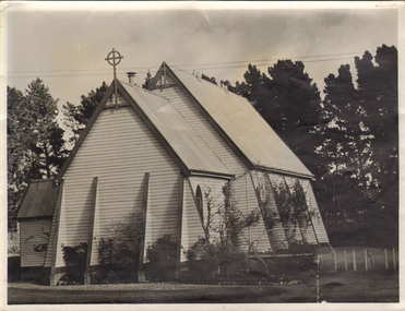 Ballarat and Queen's Anglican Grammar School
Ballarat Grammar Chapel 1953, Ballarat Church of England Grammar School Chapel
... White weatherboard chapel with high gable rood and cross with large trees in the background...See Winds of Influence, pp. 31, 52-54 Ballarat-Grammar Ballarat Bishop-Hazlewood Allendale Manifold-Hall education religion CEGS B&QAGS verso: .1) 1953 in pencil and 1953 - School Chapel typed in black on cream paper glued to photograph .2) 1953 pencilled in handwriting White weatherboard chapel with high gable rood and cross with large trees in the background Ballarat Church of England Grammar School Chapel Ballarat Grammar Chapel 1953 ...The second School chapel was brought from Allendale in 1919 and the first School chapel was subsequently taken to Wallinduc. In 1975 Manifold Hall was reconstructed to become the School's third chapel. It was consecrated on 29 November 1975 by the Right Reverend John Hazlewood, Bishop of Ballarat. See Winds of Influence, pp. 31, 52-54White weatherboard chapel with high gable rood and cross with large trees in the backgroundverso: .1) 1953 in pencil and 1953 - School Chapel typed in black on cream paper glued to photograph .2) 1953 pencilled in handwritingballarat-grammar, ballarat, bishop-hazlewood, allendale, manifold-hall, education, religion, cegs, b&qags -
Whitehorse Historical Society Inc.
Legal record - Land Title, Vermont title, 1910-1914
... Certificate of Title Vol.3261 Fol.652135, 20 acres 3 roods and 26 perches, corner Canterbury and Terrara (Station) Roads, Commonwealth Bank of Australia Ltd, to Henry Thorn 25 March 1908; with transfer record from parent title Vol.955 Fol. 190983, and transfer records from parent title Vol.2090 Fol.4059745 fro.m Henry Thorn to Shire of Nunawading, 27 September 1910 and to Louisa Stephenson Herring 3 April 1914....Certificate of Title Vol.3261 Fol.652135, 20 acres 3 roods and 26 perches, corner Canterbury and Terrara (Station) Roads, Commonwealth Bank of Australia Ltd, to Henry Thorn 25 March 1908; with transfer record from parent title Vol.955 Fol. 190983, and transfer records from parent title Vol.2090 Fol.4059745 fro.m Henry Thorn to Shire of Nunawading, 27 September 1910 and to Louisa Stephenson Herring 3 April 1914....Whitehorse Historical Society Inc. 2-10 Deep Creek Road Mitcham melbourne Certificate of Title Vol.3261 Fol.652135, 20 acres 3 roods and 26 perches, corner Canterbury and Terrara (Station) Roads, Commonwealth Bank of Australia Ltd, to Henry Thorn 25 March 1908; with transfer record from parent title Vol.955 Fol. 190983, and transfer records from parent title Vol.2090 Fol.4059745 fro.m Henry Thorn to Shire of Nunawading, 27 September 1910 and to Louisa Stephenson Herring 3 April 1914. ...Certificate of Title Vol.3261 Fol.652135.Certificate of Title Vol.3261 Fol.652135, 20 acres 3 roods and 26 perches, corner Canterbury and Terrara (Station) Roads, Commonwealth Bank of Australia Ltd, to Henry Thorn 25 March 1908; with transfer record from parent title Vol.955 Fol. 190983, and transfer records from parent title Vol.2090 Fol.4059745 fro.m Henry Thorn to Shire of Nunawading, 27 September 1910 and to Louisa Stephenson Herring 3 April 1914.Certificate of Title Vol.3261 Fol.652135.thorn, henry, shire of nunawading, canterbury road vermont, terrara road vermont, herring, louisa stephenson, commonwealth bank of australia, vermont reserve -
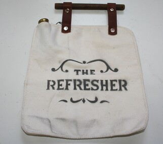 Trafalgar Holden Museum
Accessory - Canteen
... Two leather straps with a wooden rood as a carry handle...Two leather straps with a wooden rood as a carry handle Accessory Canteen ...Used to carry water for drinking while riding a horseAs manufactured and sold by Holden and FrostRectangular shaped canvas container with brass screw top filler tube. Two leather straps with a wooden rood as a carry handleThe Refreshercanteen, water container -
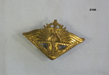 Bendigo Military Museum
Award - RETURNED FROM ACTIVE SERVICE BADGE, C. 1940
... Returned from Active Service badge. Maker - G and E Rood....Bendigo Military Museum 37 - 39 Pall Mall Bendigo goldfields Returned from Active Service badge. Maker - G and E Rood. Badges RAS On rear, “A 1454” Rising Sun badge (rising sun symbol, anchor, out-stretched wings) over boomerang. ...Returned from Active Service badge. Maker - G and E Rood.Rising Sun badge (rising sun symbol, anchor, out-stretched wings) over boomerang. Gold coloured. Two rings affixed to back (no fastener) of badge. “Returned from active service badge”On rear, “A 1454”badges, ras -
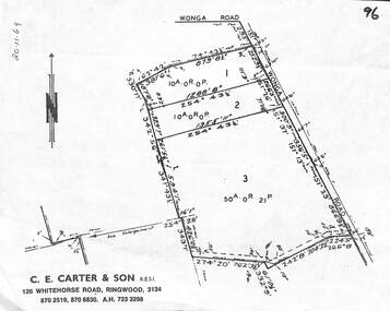 Ringwood and District Historical Society
Map, Plan of Subdivision - 3 residential allotments on Wonga Road, Ringwood, Victoria - 1969
... Real Estate Agent's diagram showing dimensions of properties, two 10 acres and one 50 acres, 0 roods, 21 perches. (2 copies)....Real Estate Agent's diagram showing dimensions of properties, two 10 acres and one 50 acres, 0 roods, 21 perches. (2 copies). Plan of Subdivision - 3 residential allotments on Wonga Road, Ringwood, Victoria - 1969 Map ...Real Estate Agent's diagram showing dimensions of properties, two 10 acres and one 50 acres, 0 roods, 21 perches. (2 copies).C.E. Carter & Son, R.E.S.I., 126 Whitehorse Road, Ringwood, Telephones 870 6024, 870 6830, 870 2519. Handwritten notation indicating doubtful location of allotments in relation to any identifiable bend as marked on the map along Wonga Road in Ringwood or Warranwood area. -
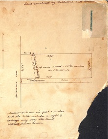 Ringwood and District Historical Society
Map, Hand-drawn map of block of land on Heatherdale Road and Palmerston Road, Ringwood, Vic. (Undated)
... Handwritten notations - Land purchased by Goldstone and Cooper; 14 acres, 1 rood and 28-8/10 perches or thereabouts; Creation of easement to S.E.C....Ringwood and District Historical Society 125A Warrandyte Road Ringwood North melbourne Handwritten notations - Land purchased by Goldstone and Cooper; 14 acres, 1 rood and 28-8/10 perches or thereabouts; Creation of easement to S.E.C. ...One of three unrelated maps on cardboard backing.Handwritten notations - Land purchased by Goldstone and Cooper; 14 acres, 1 rood and 28-8/10 perches or thereabouts; Creation of easement to S.E.C. -
Whitehorse Historical Society Inc.
Legal record - Land Title, Certificate of Title, 23/12/1927 12:00:00 AM
... 3 Acres 2 roods 8 and 7/10th perches, pt. Crown section 108 Parish of Nunawading, owned by Thomas Gifford Anderson. ...Vol. 5411 fol. 1082005 3 Acres 2 roods 8 and 7/10th perches, pt. Crown section 108 Parish of Nunawading, owned by Thomas Gifford Anderson. ...3 Acres 2 roods 8 and 7/10th perches, pt. Crown section 108 Parish of Nunawading, owned by Thomas Gifford Anderson. Vol. 5411 fol. 10820053 Acres 2 roods 8 and 7/10th perches, pt. Crown section 108 Parish of Nunawading, owned by Thomas Gifford Anderson. Vol. 5411 fol. 10820053 Acres 2 roods 8 and 7/10th perches, pt. Crown section 108 Parish of Nunawading, owned by Thomas Gifford Anderson. Vol. 5411 fol. 1082005anderson, thomas gifford, middleborough road burwood east, highbury road burwood east -
 Department of Energy, Environment and Climate Action
Gunter's Chain
... Area was shown in acres, roods and perches. Gunter's chain was used for measuring distance in surveying. ...Giving rise to the common forestry term "chainman" for the person tasked with dragging it. 1 chain = 100 links = 22 yards = 66 feet = 792 inches = 4 rods, poles or perches. 10 chains = 1 furlong 80 chains = 1 mile 1 acre = 10 square chains = 4 roods = 160 square rods, poles or perches....Area was shown in acres, roods and perches. Gunter's chain was used for measuring distance in surveying. ...Before metrication was introduced into Australia in the 1970s land was measured in chains and links. Many old parish plans show length measurements in chains and links. Area was shown in acres, roods and perches. Gunter's chain was used for measuring distance in surveying. It was designed and introduced in 1620 by English clergyman and mathematician Edmund Gunter (1581–1626). Gunter developed the measuring chain of 100 links. The chain and the link, became statutory measures in England and subsequently the British Empire. After metrication units of length were measured in meters and area in hectares. The chain was later superseded by steel ribbon tape.The 66-foot long (1 chain) Gunter's Chain was a fundamental instrument for land surveying. It is divided into 100 links (each 7.92 inches long) which are marked off into groups of 10 by brass tags with 'fingers' to indicate 10, 20, 30, 40 and 50 links from the hand grips, thus simplifying intermediate measurements. Each end of the chain is fitted with a brass hand grip. It was heavy and sturdy enough to be dragged through the bush and over rough terrain on surveying transects. Giving rise to the common forestry term "chainman" for the person tasked with dragging it. 1 chain = 100 links = 22 yards = 66 feet = 792 inches = 4 rods, poles or perches. 10 chains = 1 furlong 80 chains = 1 mile 1 acre = 10 square chains = 4 roods = 160 square rods, poles or perches.forest measurement, surveying, forests commission victoria (fcv) -
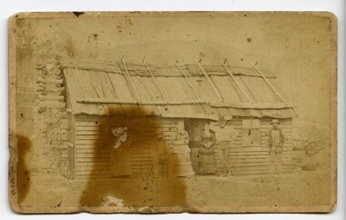 Victoria Police Museum
Carte de Visite (timber dwelling)
... Carte de Visite showing the photograph of a timber dwelling with bark rood and chimney. Four adults stand in front of the building (two female, two male) and one other male is seated...Victoria Police Museum 313 Spencer Street Docklands melbourne Greta Kelly Gang Carte de Visite showing the photograph of a timber dwelling with bark rood and chimney. Four adults stand in front of the building (two female, two male) and one other male is seated Carte de Visite (timber dwelling) ...Carte de Visite showing the photograph of a timber dwelling with bark rood and chimney. Four adults stand in front of the building (two female, two male) and one other male is seatedgreta, kelly gang -
 Ringwood and District Historical Society
Document, Property Research Notes - Reaghill, Ringwood East, Victoria. Appendix 12 - Certificate of Title - William Blood, Part of Crown Allotment 43, Parish of Ringwood, County of Mornington - 1880
... Title documents for 20 acres, 0 roods, 3 perches immediately to the north of "Reaghill" subdivided in 1931 into Alexander Road, Wood Street, Scenic Avenue,Vista Avenue and Grandview Avenue....Title documents for 20 acres, 0 roods, 3 perches immediately to the north of "Reaghill" subdivided in 1931 into Alexander Road, Wood Street, Scenic Avenue,Vista Avenue and Grandview Avenue. ...Title documents for 20 acres, 0 roods, 3 perches immediately to the north of "Reaghill" subdivided in 1931 into Alexander Road, Wood Street, Scenic Avenue,Vista Avenue and Grandview Avenue.Certificate of Title Vol 1201 Fol 240055 dated 9th September 1880 - William Blood of Ringwood, Farmer, is now the proprietor. Transfers include Bruce Anthony Langfield to Geoffrey Francis Seymour Davies of 139 Bedford Road, 20th July, 1955. -
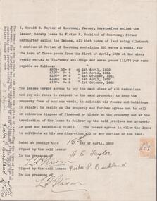 Bendigo Historical Society Inc.
Document - EDWIN BUCKLAND COLLECTION: AGREEMENT BY HAROLD E. TAYLOR AND VICTOR P. BUCKLAND
... Buckland re leasing of land Allotment 3, Section 3 12 Parish of Goornong, Containing 301 acres 3 roods for the term of Three years....Buckland re leasing of land Allotment 3, Section 3 12 Parish of Goornong, Containing 301 acres 3 roods for the term of Three years. Document EDWIN BUCKLAND COLLECTION: AGREEMENT BY HAROLD E. ...Document. Agreement by Harold E. Taylor and Victor P. Buckland re leasing of land Allotment 3, Section 3 12 Parish of Goornong, Containing 301 acres 3 roods for the term of Three years. -
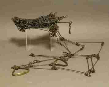 Federation University Historical Collection
Instrument - Survey Chain, Chesterman, Gunter's Survey Chain
... ...rood...In pre-metric units, there were 80 chains to 1 mile (equals 1.609km) This surveyor’s chain has an 8-inch link pitch, with markers at 10 link intervals. gunter's chain survey chain surveyor s chain perch rood surveying This metal surveyor’s chain (or Gunter's Chain) has an 8-inch link pitch, with markers at 10 link intervals, and handles at either end. ...Before metric measurement was introduced land was measured in chains and links. The chain was a precision part of a surveyor's equipment. It required frequent calibration, yet needed to be sturdy enough to be dragged through rough terrain for years. A standard survey chain is 66 feet (or 20.117m) long and made up of 100 links. Each link is 7.92 inches (approximately 201mm) long, measured from the inside of the loop. The handles are for tensioning the chain in use, they are not part of the length of the chain. In pre-metric units, there were 80 chains to 1 mile (equals 1.609km) This surveyor’s chain has an 8-inch link pitch, with markers at 10 link intervals. This metal surveyor’s chain (or Gunter's Chain) has an 8-inch link pitch, with markers at 10 link intervals, and handles at either end. A Surveyor’s Chain was 66 feet long, and made up of 100 links connected by two rings. A link in measurement includes the two rings at each end. gunter's chain, survey chain, surveyor s chain, perch, rood, surveying -
 Ringwood and District Historical Society
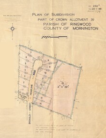
Map - Plan of Subdivision, Part of Crown Allotment 39, Parish of Ringwood, County of Mornington - 1968
... Adjoining lot 15 marked as 2 acres 3 roods 29.8 perches with house and garage....Adjoining lot 15 marked as 2 acres 3 roods 29.8 perches with house and garage. Part of Crown Allotment 39, Parish of Ringwood, County of Mornington - 1968 Map Plan of Subdivision ...Map showing residential allotments numbered 1 to 14 Headline Court, Heathmont, Victoria, off Bronaldi Street and Yallamba Place. Adjoining lot 15 marked as 2 acres 3 roods 29.8 perches with house and garage.Paul Millar & Associates, Land & Engineering Surveyors, First Floor, 14A Main Street Croydon (Phone) 723 4493. Ref. 232B Date 23.1.68 Amended 12.3.68 & 1.12.71. -
 Bendigo Historical Society Inc.
Document - MCCOLL, RANKIN AND STANISTREET COLLECTION: CENTRAL NELL GWYNNE, March - April 1943
... For sale of an area of 8 acres 0 roods 31 perches now comprising the garden of Fortuna to unlimited depth....For sale of an area of 8 acres 0 roods 31 perches now comprising the garden of Fortuna to unlimited depth. ...Document. Manila folder & 4 letters, 1 map The 4 letters pertain to an application by the Commonwealth of Australia to the lands Depart. For sale of an area of 8 acres 0 roods 31 perches now comprising the garden of Fortuna to unlimited depth.McColl, Rankin & Stanistreetorganization, business, central nell gwynne, mccoll, rankin & stanistreet, central nell gwynne gmc, south nell gwynne, gold mining, dept of mines -
 Federation University Historical Collection
Document, Victoria: Land Purchase, Edward Ager Wynne, 1856, 23 January 1856
... .1 Document outlining the purchase of Lot No. 39: 16 acres, 3 roods, 9 perches situated in the County of Talbot, Parish of Glendaruel by Edward Ager Wynne of Melbourne for the sum of Seventeen Pounds Thirteen Shillings .2 Document outlining the purchase of Lot No. 30: 50 acres, 2 roods, 38 perches situated in the County of Talbot, Parish of Glendaruel bu Edward Ager Wynne of Melbourne for the sum of Fifty Pounds Fourteen Shillings and Nine Pence Both documents were witnessed by Major-General Edward Macarthur the Senior, Officer in Command of Our Land Forces...Barker Library (top floor) Mount Helen goldfields .1 Document outlining the purchase of Lot No. 39: 16 acres, 3 roods, 9 perches situated in the County of Talbot, Parish of Glendaruel by Edward Ager Wynne of Melbourne for the sum of Seventeen Pounds Thirteen Shillings .2 Document outlining the purchase of Lot No. 30: 50 acres, 2 roods, 38 perches situated in the County of Talbot, Parish of Glendaruel bu Edward Ager Wynne of Melbourne for the sum of Fifty Pounds Fourteen Shillings and Nine Pence Both documents were witnessed by Major-General Edward Macarthur the Senior, Officer in Command of Our Land Forces county of talbot parish of glenaruel acres roods perches edward ager wynne major-general edward macarthue land purchase agreement Date: 23 January 1856 Signature: E Macarthur - Major General of Our Land Forces Official Seal Thick cream paper, hand written Victoria: Land Purchase, Edward Ager Wynne, 1856 Document ....1 Document outlining the purchase of Lot No. 39: 16 acres, 3 roods, 9 perches situated in the County of Talbot, Parish of Glendaruel by Edward Ager Wynne of Melbourne for the sum of Seventeen Pounds Thirteen Shillings .2 Document outlining the purchase of Lot No. 30: 50 acres, 2 roods, 38 perches situated in the County of Talbot, Parish of Glendaruel bu Edward Ager Wynne of Melbourne for the sum of Fifty Pounds Fourteen Shillings and Nine Pence Both documents were witnessed by Major-General Edward Macarthur the Senior, Officer in Command of Our Land Forces Thick cream paper, hand writtenDate: 23 January 1856 Signature: E Macarthur - Major General of Our Land Forces Official Seal county of talbot, parish of glenaruel, acres, roods, perches, edward ager wynne, major-general, edward macarthue, land purchase agreement -
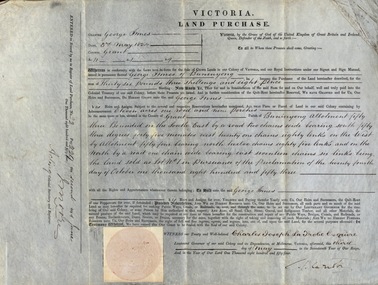
 Ringwood and District Historical Society
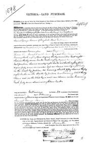
Land Purchase Document, Land Purchase for Samuel George Isaacs of Elizabeth Street, Melbourne for 148 acres, 2 roods and 9 perches in County of Mornington Parish of Ringwood - 1858, Feb-1858
... 1598 laminated copy on cardboard of Victoria - Land Purchase for Samuel George Isaacs of Elizabeth Street, Melbourne for 148 acres, 2 roods and 9 perches in County of Mornington Parish of Ringwood for the sum of 148 pounds 11 shillings and two pence. ...+Additional Keywords: Isaacs, Samuel George Land Purchase for Samuel George Isaacs of Elizabeth Street, Melbourne for 148 acres, 2 roods and 9 perches in County of Mornington Parish of Ringwood - 1858. ...1598 laminated copy on cardboard of Victoria - Land Purchase for Samuel George Isaacs of Elizabeth Street, Melbourne for 148 acres, 2 roods and 9 perches in County of Mornington Parish of Ringwood for the sum of 148 pounds 11 shillings and two pence. +Additional Keywords: Isaacs, Samuel Georgeas above -
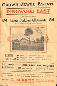 Ringwood and District Historical Society
Flyer, Subdivisional Land Sale Brochure, Crown Jewel Estate, Ringwood East, Vic. - c.1925
... In May 1884, George Smart of Bulleen Road Kew, brickmaker, bought the 23 acres one rood and twenty nine and three tenths perches, or 9.4834 hctares from Arthur Bailey Clements of Ringwood for the sum of 600 pound sterling. ...Ringwood and District Historical Society 125A Warrandyte Road Ringwood North melbourne In May 1884, George Smart of Bulleen Road Kew, brickmaker, bought the 23 acres one rood and twenty nine and three tenths perches, or 9.4834 hctares from Arthur Bailey Clements of Ringwood for the sum of 600 pound sterling. ...In May 1884, George Smart of Bulleen Road Kew, brickmaker, bought the 23 acres one rood and twenty nine and three tenths perches, or 9.4834 hctares from Arthur Bailey Clements of Ringwood for the sum of 600 pound sterling. (Extract from The Story of the Crown Jewel Estate in Ringwood East pdf)Double sided folded page with black and red print on both sides advertising auction sale of residential and business sites and highlighting local facilities, services and layout of the estate.Subdivision includes Mount Dandenong Road, Valda Avenue, Evon Avenue, Mirabel Avenue, and Velma Grove. (Agent) T. Burkitt, Box 12 Ringwood, Phone Ringwood 157. Vendor: A. Marshall Miller, McDonald Street, Mordialloc. Solicitors: Russell, Bona and Russell, 19 Queen Street Melbourne, and Ringwood - Phone Cent. 4308. -
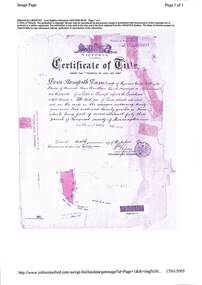
 Federation University Historical Collection
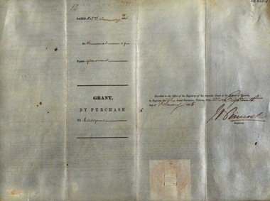
Document, Grant, by Purchase, to George Innes, 3 May 1854, 1854
... The price paid was for eleven acres one rood and nine perches. The document is witnessed by Charles Joseph La Trobe Esquire on 3 May 1854 in Melbourne. ...The price paid was for eleven acres one rood and nine perches. The document is witnessed by Charles Joseph La Trobe Esquire on 3 May 1854 in Melbourne. ...George Innes purchased land in the County of Grant, Parish of Buninyong, for the sum of Thirty-six pounds, three shillings and eight pence. The price paid was for eleven acres one rood and nine perches. The document is witnessed by Charles Joseph La Trobe Esquire on 3 May 1854 in Melbourne. La Trobe was Lieutenant Governor of the Colony of VictoriaThick paper written on by hand. Top edge and right-hand corner damaged Dated 3 May 1854 Signature of Charles Joseph La Trobe and J Moorela trobe, lieutenant governor, george innes, county of grant, parish of buninyong, land purchase -
 Ringwood and District Historical Society
Document, Property Research Notes - Reaghill, Ringwood East, Victoria. Appendix 2 - Title in the name of Dora Stanisforth Davies, 6 October 1909
... Certificate of Title Vol 3384 Fol 676021, Dora Stanisforth Davies, wife of Seymour George Pilkington Davies of Burwood Road, Hawthorn, Bank Manager, is now the proprietor (of) 24 acres, 3 roods, 20 perches or there abouts being part of Crown Allotment 43, Parish of Ringwood, County of Mornington, dated 6th October, 1909....Certificate of Title Vol 3384 Fol 676021, Dora Stanisforth Davies, wife of Seymour George Pilkington Davies of Burwood Road, Hawthorn, Bank Manager, is now the proprietor (of) 24 acres, 3 roods, 20 perches or there abouts being part of Crown Allotment 43, Parish of Ringwood, County of Mornington, dated 6th October, 1909. ...Certificate of Title Vol 3384 Fol 676021, Dora Stanisforth Davies, wife of Seymour George Pilkington Davies of Burwood Road, Hawthorn, Bank Manager, is now the proprietor (of) 24 acres, 3 roods, 20 perches or there abouts being part of Crown Allotment 43, Parish of Ringwood, County of Mornington, dated 6th October, 1909.Proprietors and transferees include: Geoffrey Frances Seymour Davies, 6 December, 1946.