Showing 11 items matching "route 301"
-
 Melbourne Tram Museum
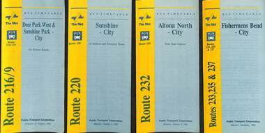
Ephemera - Timetable - bus - The Met - set of 24, The Met, 1992 & 1993
... ...route 301...All dated during1993 unless noted otherwise. 1 - Route 216/9 - Deer Park West & Sunshine Park - City 2 - Route 220 - Sunshine - City - 1992 3 - Route 232 - Altona North - City - 1992 4 - Route 233 - Fishermens Bend - City - 1992 5 - Route 254 - Northland Shopping Centre - City - 1992 6 - Route 256 - La Trobe Uni - City - 1992 7 - Routes 258 & 259 - Northland Shopping Centre, and La Trobe Uni - City via Eastern Freeway - 1992 8 - Route 260 etc - Deep Creek Templestow - Donvale - City 9 - Route 264 - Mitcham, Donvale City 10 - Route 265 - Deep Creek - City 11 - Route 602 - Brighton - city 12 - Route 269, 291 and 296 - Greensborough, Heidelberg & Newmans Road to Box Hill 13 - Route 272 - Warrandyte - City 14 - Route 276 & 278 - Warrandyte - City 15 - Route 284 & 270 - East Kew - City or Box Hill 16 - Route 285 - The Pines - Box Hill 17 - Route 286 & 288 - The Pines and Templestowe - Box Hill 18 - Route 290 - North Nunawading - Box Hill 19 - Route 292 etc - Box Hill, Deep Creek, Ringwood, Warrandyte 20 - Route 301, 281 315 - Ringwood, Park Orchards and Donvale - City 21 - Route 305 - Box Hill - Ringwood 22 - Route 366 & 367 - Ringwood - Croydon 23 - Route 600 - St Kilda - Brighton Beach - 1992 24 - Route 601 - Gardenvale - City - 1992...All dated during1993 unless noted otherwise. 1 - Route 216/9 - Deer Park West & Sunshine Park - City 2 - Route 220 - Sunshine - City - 1992 3 - Route 232 - Altona North - City - 1992 4 - Route 233 - Fishermens Bend - City - 1992 5 - Route 254 - Northland Shopping Centre - City - 1992 6 - Route 256 - La Trobe Uni - City - 1992 7 - Routes 258 & 259 - Northland Shopping Centre, and La Trobe Uni - City via Eastern Freeway - 1992 8 - Route 260 etc - Deep Creek Templestow - Donvale - City 9 - Route 264 - Mitcham, Donvale City 10 - Route 265 - Deep Creek - City 11 - Route 602 - Brighton - city 12 - Route 269, 291 and 296 - Greensborough, Heidelberg & Newmans Road to Box Hill 13 - Route 272 - Warrandyte - City 14 - Route 276 & 278 - Warrandyte - City 15 - Route 284 & 270 - East Kew - City or Box Hill 16 - Route 285 - The Pines - Box Hill 17 - Route 286 & 288 - The Pines and Templestowe - Box Hill 18 - Route 290 - North Nunawading - Box Hill 19 - Route 292 etc - Box Hill, Deep Creek, Ringwood, Warrandyte 20 - Route 301, 281 315 - Ringwood, Park Orchards and Donvale - City 21 - Route 305 - Box Hill - Ringwood 22 - Route 366 & 367 - Ringwood - Croydon 23 - Route 600 - St Kilda - Brighton Beach - 1992 24 - Route 601 - Gardenvale - City - 1992 Yields information about some of The Met bus services 1993 timetables The Met route 216 route 220 route 232 route 233 Route 254 route 258 Route 259 route 260 route 264 route 265 route 256 Route 602 route 269 Route 272 route 276 route 284 route 270 route 285 route 286 route 288 Route 290 route 292 route 301 route 305 route 366 route 367 route 600 route 601 Set of 24 The Met timetables, DL size, printed in two colours. ...SSet of 24 The Met bus timetables, with diagrammatic map, major stops and contact details. All dated during1993 unless noted otherwise. 1 - Route 216/9 - Deer Park West & Sunshine Park - City 2 - Route 220 - Sunshine - City - 1992 3 - Route 232 - Altona North - City - 1992 4 - Route 233 - Fishermens Bend - City - 1992 5 - Route 254 - Northland Shopping Centre - City - 1992 6 - Route 256 - La Trobe Uni - City - 1992 7 - Routes 258 & 259 - Northland Shopping Centre, and La Trobe Uni - City via Eastern Freeway - 1992 8 - Route 260 etc - Deep Creek Templestow - Donvale - City 9 - Route 264 - Mitcham, Donvale City 10 - Route 265 - Deep Creek - City 11 - Route 602 - Brighton - city 12 - Route 269, 291 and 296 - Greensborough, Heidelberg & Newmans Road to Box Hill 13 - Route 272 - Warrandyte - City 14 - Route 276 & 278 - Warrandyte - City 15 - Route 284 & 270 - East Kew - City or Box Hill 16 - Route 285 - The Pines - Box Hill 17 - Route 286 & 288 - The Pines and Templestowe - Box Hill 18 - Route 290 - North Nunawading - Box Hill 19 - Route 292 etc - Box Hill, Deep Creek, Ringwood, Warrandyte 20 - Route 301, 281 315 - Ringwood, Park Orchards and Donvale - City 21 - Route 305 - Box Hill - Ringwood 22 - Route 366 & 367 - Ringwood - Croydon 23 - Route 600 - St Kilda - Brighton Beach - 1992 24 - Route 601 - Gardenvale - City - 1992Yields information about some of The Met bus services 1993Set of 24 The Met timetables, DL size, printed in two colours.timetables, the met, route 216, route 220, route 232, route 233, route 254, route 258, route 259, route 260, route 264, route 265, route 256, route 602, route 269, route 272, route 276, route 284, route 270, route 285, route 286, route 288, route 290, route 292, route 301, route 305, route 366, route 367, route 600, route 601 -
 Sunshine and District Historical Society Incorporated
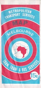
Map - Joseph 'Joe' Wlodarczyk Collection - Metropolitan Transport Services Map, No Date
... Brimbank Library, 301 Hampshire Road, Sunshine 3020. melbourne This combined public transport map provides information on services operated by the Melbourne and Metropolitan Tramways Board, private bus operators and Victorian Railways, Bus Proprietors' Association and the Transport Regulations Board. It was published in the interest of travelers in the Melbourne metropolitan area. This map shows Melbourne's transport network prior to the City Loop being built. Locally the map shows the St. Albans electrification line stopping at the St. Albans Railway Station. Railways Bus Routes ...This combined public transport map provides information on services operated by the Melbourne and Metropolitan Tramways Board, private bus operators and Victorian Railways, Bus Proprietors' Association and the Transport Regulations Board. It was published in the interest of travelers in the Melbourne metropolitan area.This map shows Melbourne's transport network prior to the City Loop being built. Locally the map shows the St. Albans electrification line stopping at the St. Albans Railway Station.Metropolitan Transport Services Map Melbourne Tram, train & Bus Services 15crailways, bus routes, tramlines -
 Sunshine and District Historical Society Incorporated
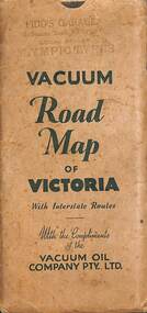
Map - Joseph 'Joe' Wlodarczyk Collection - Vacuum Road Map Of Victoria
... Brimbank Library, 301 Hampshire Road, Sunshine 3020. melbourne Road travelers relied on foldable paper maps to chart their journeys, especially when venturing beyond familiar territory. Maps helped identify highways, towns, and landmarks, enabling drivers to choose efficient or scenic routes. ...Road travelers relied on foldable paper maps to chart their journeys, especially when venturing beyond familiar territory. Maps helped identify highways, towns, and landmarks, enabling drivers to choose efficient or scenic routes. These maps were indispensable tools for travel, planning, and exploration. This map also identified the location of Vacuum Oil Company Dealerships throughout Victoria. These paper-based maps were used before Global Positioning System "GPS" revolutionized navigation. - Envelope - Pidd's Garage Melbourne Road Newport Local Dealer Olympic Tyres Vacuum Road Map of Victoria with Interstate Routes with the compliments of the Vacuum Oil Company Pty Ltd. Map - Vacuum Road Guide of Victoria Visit Melbourne Centenary 1934-5 Vacuum Oil Company Pty Ltdmap, vacuum oil company, pidd's garage, melbourne road, newport, joseph 'joe' wlodarczyk -
 Sunshine and District Historical Society Incorporated
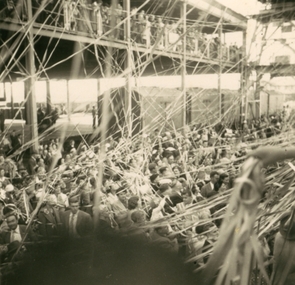
Photograph - Skaubryn Migrant Ship
... Brimbank Library, 301 Hampshire Road, Sunshine 3020. melbourne The MS Skaubryn was a Norwegian passenger liner launched in 1950 and used extensively on the Europe–Australia migrant route. ...The MS Skaubryn was a Norwegian passenger liner launched in 1950 and used extensively on the Europe–Australia migrant route. It carried more than a thousand migrants per voyage and was considered well‑equipped for post‑war mass migration. The Skaubryn made multiple voyages from European ports to Australia between 1951 and 1958, carrying migrants from Germany, the Netherlands, Malta, and elsewhere. It also made occasional voyages to Canada and troop transport charters. The Skaubryn is best remembered for its catastrophic fire in the Indian Ocean on 31 March 1958. 5476.01 - Skaubryn Migrant Ship Photograph.jpg 5476.02 - Migrant Ship C1950's Photograph.jpg 5476.03 - Migrant Ship C1950's Photograph.jpg skaubryn migrant ship, migrants, immigration -
 Sunshine and District Historical Society Incorporated
Photograph - Ashley Street Railway Underpass Photographs
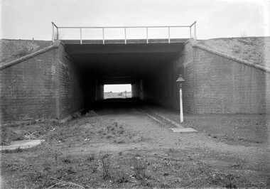
... Brimbank Library, 301 Hampshire Road, Sunshine 3020. melbourne The Tottenham Yard began as a modest goods yard supporting local industries in Braybrook, Tottenham, and West Footscray, the Sunshine industrial belt and the nearby munitions and explosives factories Key features of the early yard included a small number of sidings, a goods shed, a basic loading / unloading facilities and a connection to the Tottenham triangle (Sunshine–Footscray–North Melbourne junction). As the yard expanded with additional siding and larger marshalling areas, there was a requirement to maintain the Ashley Street North – South access route ...The Tottenham Yard began as a modest goods yard supporting local industries in Braybrook, Tottenham, and West Footscray, the Sunshine industrial belt and the nearby munitions and explosives factories Key features of the early yard included a small number of sidings, a goods shed, a basic loading / unloading facilities and a connection to the Tottenham triangle (Sunshine–Footscray–North Melbourne junction). As the yard expanded with additional siding and larger marshalling areas, there was a requirement to maintain the Ashley Street North – South access route for private and commercial travel. The work involved to solve this problem was to elevate the railway yard and place Ashley Street through a tunnel. This railway underpass for many years was simply known as the Ashley Street Tunnel. By the 1970s, the Tottenham Yard had become one of the largest freight yards in Victoria, second only to Dynon. In the 1982, the level crossing gates at the southern end of tunnel were removed, the tunnel extended southwards and the former Tottenham Railway Station was replaced with an elevated one above the new tunnel extension. During these works the road surface level was lowered to allow for higher trucks to pass through. At this point of time, the reference to tunnel was replaced with underpass. During the 1990’s and 2000’s, there was a decline in the use of the Tottenham Yard and many sidings were removed, shorten, converted to storage or left unused. Today the yard is used for wagon storage, crew changes, light shunting and providing access to the Tottenham triangle and Sunshine corridor.These photographs were taken shortly after the tunnel was completed.5335.01 - Ashley Street Railway Underpass Looking North Photo 01.jpg 5335.02 - Ashley Street Railway Underpass Looking South Photo 02.jpgashley street, railway line, tottenham -
 Melbourne Tram Museum
Album - Robert Thomson Slide Collection - box 16
... At East Preston terminus – both route 88 RT382 26-1-1980 SW5 812 route 67 at Carnegie terminus RT383 28-1-1980 MMTB Austerity bus No. 301 RT384 26-1-1980 SW5 818? ...At East Preston terminus – both route 88 RT382 26-1-1980 SW5 812 route 67 at Carnegie terminus RT383 28-1-1980 MMTB Austerity bus No. 301 RT384 26-1-1980 SW5 818? ...Photo - see pdf file for further information. Number Date Brief Description Box 16 RT372 23-1-1980 W2 271, High St Kew reconstruction trackwork – route 48 RT373 23-1-1980 W2 504 Burwood Road RT374 23-1-1980 Z7 East Burwood terminus RT375 23-1-1980 Z26 Burwood Highway, route 75 RT376 23-1-1980 W2 255 North Balwyn terminus, route 48 RT377 24-1-1980 W5 at North Coburg terminus – route 19 RT378 24-1-1980 Z37 (route 19) and a W route 20 at North Coburg terminus RT379 24-1-1980 W2 378? Park St St Kilda terminus, route 12 RT380 24-1-1980 Z121 route 88 at Bourke St terminus with Spencer St station in background RT381 25-1-1980 Z1 118 and another Z81? At East Preston terminus – both route 88 RT382 26-1-1980 SW5 812 route 67 at Carnegie terminus RT383 28-1-1980 MMTB Austerity bus No. 301 RT384 26-1-1980 SW5 818? And SW6 965 at Carnegie Glen Huntly Road at start of the single line Truganini Road – note the single track signs. Both route 67. RT385 26-1-1980 W2 504 at East Malvern Darling Road – route 3 RT386 26-1-1980 SW5 787 route 52, Mathews Ave. RT387 26-1-1980 SW5 684? Airport West terminus, route 52, RT388 26-1-1980 High St Kew track reconstruction, W6 986, route 48 RT389 26-1-1980 SW6 965 route 67, Glen Huntly Road level crossing RT390 27-1-1980 SW6 962 Collins St route 42 Spencer St terminus RT391 27-1-1980 Z3 121, route 88 Bourke St Mal with parked cars. RT392 27-1-1980 Z3 188? Bourke St route 96 RT393 27-1-1980 3MP tram Camberwell Route 72 at Gardiner level crossing RT394 28-1-1980 MMTB Bus 370, Leyland OPS1 on display RT395 28-1-1980 MAN Bus 103, on display showing Doncaster Depot Demonstrates the work of Robert Thomson in photography, collection and/or production of slidesAssembled album in a black presentation folder of 24 colour slides, collected or produced by Robert Thomson. A list of all photographs with details has been compiled. All rights reserved for all photos., melbourne, tramways, trams, tram 271, high st kew, trackworks, route 48, tram 504, tram 7, east burwood, tram 26, tram 255, north coburg, route 19, tram 37, park st st kilda, tram 121, bourke st, spencer st, tram 118, east preston, route 88, route 12, route 67, carnegie, tram 812, tram 67, buses, tram 965, truganini road, route 3, route 52, tram 787, tram 986, level crossings, glen huntly rd, matthews ave, tram 962, collins st, route 42, tram 188, route 72, gardiner -
 Melbourne Tram Museum
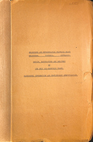
Document - Specification, Melbourne & Metropolitan Tramways Board (MMTB), "Design, Manufacture and delivery of 100 only all-electric trams", Jun. 1965
... Comprises: 1 - Conditions of Tendering - 1 page 2 - Conditions of Contract - 4 pages 3 - Contents - 3 pages 4 - Notes for prospective tenderers - dated June 1965 5 - General nature of contract - 21 pages 6 - Appendix A - climate data - two sheets 7 - List of 14 appended drawings 8 - O.6887A - cross section of trolley wire 9 - P.13855 - Glenferrie Road, Longitudinal Section 10 - P.13856 - Wattle Park Route 11 - P.13857 - East Preston Route 12 - P13858 - Concrete track construction 13 - P13859 - Open track construction 14 - P.13860 - Paved ballast track construction 15 - P.13887 - Tram Route - locations of substations and section switches 16 - P.13888 - Minimum radius service curves to give minimum clearance between tramcars 17 - P.13889 - Grooved Rail - 102 pounds per yard and tire profile 18 - R10-301 - Loading gauge, proposed electric tramcars 19 - R9706K - Rolling stock data, tramcars 20 - R10306 - Collins Points Shifter - Wiring diagram. 21 - Schedule of data to be supplied by the tenderer 22 - notes on Automatic Points shifters - 2 sheets 23 - Tender prices and delivery periods - 2 sheets. ...Comprises: 1 - Conditions of Tendering - 1 page 2 - Conditions of Contract - 4 pages 3 - Contents - 3 pages 4 - Notes for prospective tenderers - dated June 1965 5 - General nature of contract - 21 pages 6 - Appendix A - climate data - two sheets 7 - List of 14 appended drawings 8 - O.6887A - cross section of trolley wire 9 - P.13855 - Glenferrie Road, Longitudinal Section 10 - P.13856 - Wattle Park Route 11 - P.13857 - East Preston Route 12 - P13858 - Concrete track construction 13 - P13859 - Open track construction 14 - P.13860 - Paved ballast track construction 15 - P.13887 - Tram Route - locations of substations and section switches 16 - P.13888 - Minimum radius service curves to give minimum clearance between tramcars 17 - P.13889 - Grooved Rail - 102 pounds per yard and tire profile 18 - R10-301 - Loading gauge, proposed electric tramcars 19 - R9706K - Rolling stock data, tramcars 20 - R10306 - Collins Points Shifter - Wiring diagram. 21 - Schedule of data to be supplied by the tenderer 22 - notes on Automatic Points shifters - 2 sheets 23 - Tender prices and delivery periods - 2 sheets. ...Specification or Tender Document - titled "Design, Manufacture and delivery of 100 only all-electric trams", and "Background Information and Preliminary Specification", dated June 1965. Bound into a brown foolscap card cover. Details the conditions of tender, conditions of contract, notes, specification, gives background information about Melbourne, dimensions, performance, drivers and conductors, trucks, wheels, brakes, electrical equipment, control panels and drawings. The drawings give a map of the system, typical city route, Glenferrie Road route (grade diagram), concrete track construction, min. radius curves, loading gauge, all-electric tram and mounting details for the trolley base, schedule of prices, tender form, form of contract, schedule of information to be provided by the tenderer. Comprises: 1 - Conditions of Tendering - 1 page 2 - Conditions of Contract - 4 pages 3 - Contents - 3 pages 4 - Notes for prospective tenderers - dated June 1965 5 - General nature of contract - 21 pages 6 - Appendix A - climate data - two sheets 7 - List of 14 appended drawings 8 - O.6887A - cross section of trolley wire 9 - P.13855 - Glenferrie Road, Longitudinal Section 10 - P.13856 - Wattle Park Route 11 - P.13857 - East Preston Route 12 - P13858 - Concrete track construction 13 - P13859 - Open track construction 14 - P.13860 - Paved ballast track construction 15 - P.13887 - Tram Route - locations of substations and section switches 16 - P.13888 - Minimum radius service curves to give minimum clearance between tramcars 17 - P.13889 - Grooved Rail - 102 pounds per yard and tire profile 18 - R10-301 - Loading gauge, proposed electric tramcars 19 - R9706K - Rolling stock data, tramcars 20 - R10306 - Collins Points Shifter - Wiring diagram. 21 - Schedule of data to be supplied by the tenderer 22 - notes on Automatic Points shifters - 2 sheets 23 - Tender prices and delivery periods - 2 sheets. See Reg Item 2266 for the 1972 version and 1583 for the August 1966 version. See Reg Item 4049 for associated newspaper cuttings. See file htd4667i1.pdf for scans of the drawings.In ink in top right hand corner - "Lees"trams, tramways, specification, tenders, z class, mmtb, melbourne -
 Sunshine and District Historical Society Incorporated
Photograph - Rockbank Inn Photograph, John Alchin, 2007
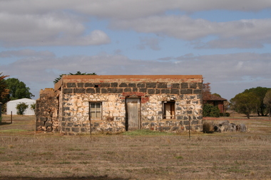
... 301 Hampshire Road, Sunshine 3020. melbourne Rockbank was once part of the Braybrook Road District. In 1871, the Road District became the Shire of Braybrook. In 1916, this district was transferred to the Shire of Melton. In 1951, further land was lost to the Shire of Melton. The Rockbank Inn built C1853 was located on Beatty's Road, one of the main routes ...Rockbank was once part of the Braybrook Road District. In 1871, the Road District became the Shire of Braybrook. In 1916, this district was transferred to the Shire of Melton. In 1951, further land was lost to the Shire of Melton. The Rockbank Inn built C1853 was located on Beatty's Road, one of the main routes from Melbourne to Ballarat during the gold rush. In December 1854, troops of the 12th and 40th Regiments marching to suppress the Eureka Stockade stopped at the inn: After the closure of the Inn C1870, it became a residence of the Beattie family for nearly 90 years. The building was then abandoned C1960 and it then fell into ruin. Past owners of the site include: 1840s–1853 William Cross Yuille. Original pastoral run holder. In 1853, he sold of the run to W.C.T. Clarke but retained the 20‑acre inn site. 1853–c.1855 James Stewart & John Brown. Possibly built earliest section of the inn. c.1855–1870 John Gray. Commissioned 1855 bluestone additions; trustees sold in 1870. c.1870–c.1960 Beattie family. Long‑term residents; inn no longer operated as hotel. The Rockbank Inn is one of the few surviving sites directly tied to the Eureka Stockade Rebellion.5590.01 - Rockbank Inn Beattys Rd 2007.JPGbeatty's road, rockbank, rockbank inn, beattie -
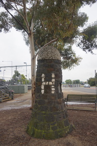 Sunshine and District Historical Society Incorporated
Photograph - Sydenham Hume & Hovell Cairn, John Alchin, 2020
... 301 Hampshire Road, Sunshine 3020. melbourne This is one of two Hume and Hovell Cairns erected in the City of Brimbank. The Sydenham cairn was erected on 19 December 1924, exactly 100 years after the explorers passed through the district. It was built by residents of St Albans and Sydenham as part of a statewide centenary program that installed 37 monuments along the expedition route ...This is one of two Hume and Hovell Cairns erected in the City of Brimbank. The Sydenham cairn was erected on 19 December 1924, exactly 100 years after the explorers passed through the district. It was built by residents of St Albans and Sydenham as part of a statewide centenary program that installed 37 monuments along the expedition route. The monument has been moved twice due to road works as it was originally on the north‑west corner of Taylors Road & Sydenham Road. The first time it was relocated it was moved to position very close to the original position. The second time it was moved approximately 200 metres in a southerly direction and is now located at the Keilor Plains Station (East Esplanade). In November 2024, the Sydenham & District Historical Society held a 100‑year anniversary event for the cairn and a 200‑year anniversary of the 1824 expedition. Attendees included City of Brimbank Mayor Thuy Dang, Members of Natalie Suleyman MP’s office and local historians including Karen Schmidt and Bruce Lancashire. 5623.01 - Sydenham Hume And Hovell Monument 2nd April 2020 Photo 02.JPG 5623.02 - Sydenham Hume And Hovell Monument 2nd April 2020 Photo 03.JPG 5623.03 - Sydenham Hume And Hovell Monument 2nd April 2020 Photo 01.JPG Hume & Hovell passed here Dec. 19th 1824. Erected by Residents of St. Albans and Sydenham, December 19th 1924. sydenham, hume and hovell, keilor plains railway station -
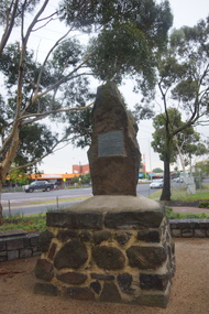 Sunshine and District Historical Society Incorporated
Photograph - Deer Park Hume & Hovell Cairn, John Alchin, 2020
... 301 Hampshire Road, Sunshine 3020. melbourne This is one of two Hume and Hovell Cairns erected in the City of Brimbank. The Deer Park Cairn was erected in 1924, one hundred years after the explorers passed through the district. It was built by ratepayers of Shire of Braybrook as part of a statewide centenary program that installed 37 monuments along the expedition route ...This is one of two Hume and Hovell Cairns erected in the City of Brimbank. The Deer Park Cairn was erected in 1924, one hundred years after the explorers passed through the district. It was built by ratepayers of Shire of Braybrook as part of a statewide centenary program that installed 37 monuments along the expedition route. The monument has been moved twice due to widening of Ballarat Road. The first time was in the 1960's. More recently it was moved onto the Deer Park Primary School land just outside the fence line. The original location is slightly southwest of the current position.5624.02 - Deer Park Hume And Hovell Monument 2nd April 2020 Photo 05.JPG 5624.01 - Deer Park Hume And Hovell Monument 2nd April 2020 Photo 04.JPG 5624.03 - Deer Park Hume And Hovell Monument 2nd April 2020 Photo 08.JPGhume and hovell, ballarat road, deer park -
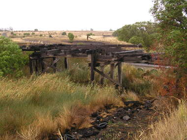 Sunshine and District Historical Society Incorporated
Photograph - Beattys Road Bridge Rockbank Photographs, John Alchin, 2008
... 301 Hampshire Road, Sunshine 3020. melbourne Rockbank was once part of the Braybrook Road District. In, 1871 the Road District became the Shire of Braybrook. In 1916, this district was transferred to the Shire of Melton. In 1951, further land was lost to the Shire of Melton. During the early days of the Ballarat gold rush, Beatty's Road was one of the main routes ...Rockbank was once part of the Braybrook Road District. In, 1871 the Road District became the Shire of Braybrook. In 1916, this district was transferred to the Shire of Melton. In 1951, further land was lost to the Shire of Melton. During the early days of the Ballarat gold rush, Beatty's Road was one of the main routes from Melbourne to Ballarat via Keilor . In December 1854, troops of the 12th and 40th Regiments marching to suppress the Eureka Stockade would have used this route before stopping at the Rockbank Inn, which was located on Beatty's Road, further west towards Melton. One of the photographs captures a Terrestrial Road surface (Local Blue Stone), one of the district's early sealed section of road. 5644.01 - Beattys Road Bridge Rockbank 2008 Photo 01.JPG 5644.02 - Beattys Road Bridge Rockbank 2008 Photo 02.JPG 5644.03 - Beattys Road Terrestrial Road Surface Rockbank 2008 Photo 04.JPG 5644.04 - Beattys Road Paddocks Rockbank 2008 Photo 03.JPGbeatty's road, rockbank, rockbank inn, terrestrial road