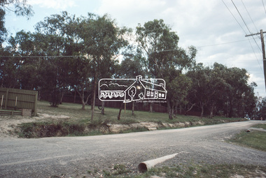
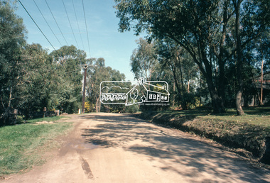
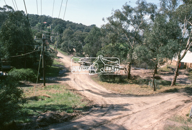
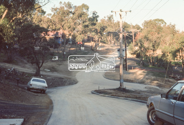
Showing 159 items matching sackville%20street
-
 Eltham District Historical Society Inc
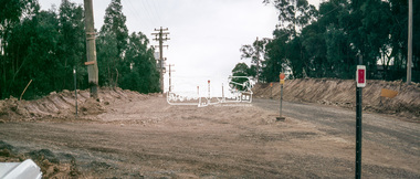
Slide, Looking north along Bolton Street at intersection with Sackville Street, Eltham, 18 July 1972, 1972
Reconstruction works by Eltham Shire Council, Bolton Street, Eltham, 18 July 197235 mm colour positive transparency Mount - Agfacolor Service (Blue)bolton steet, eltham, eltham shire council, infrastructure, , road construction, sackville street -
 Eltham District Historical Society Inc
Slide, Looking north along Bolton Street at intersection with Sackville Street, Eltham, 18 July 1972, 1972
Reconstruction works by Eltham Shire Council, Bolton Street, Eltham, 18 July 1972Digital panorama created from two 35 mm colour positive transparency Mount - Agfacolor Service (Blue)bolton steet, eltham, eltham shire council, infrastructure, , road construction, sackville street -
 Eltham District Historical Society Inc
Slide, Looking south along Bolton Street near intersection with Sackville Street, Eltham, 18 July 1972, 1972
Reconstruction works by Eltham Shire Council, Bolton Street, Eltham, 18 July 197235 mm colour positive transparency Mount - Agfacolor Service (Blue)bolton steet, eltham, eltham shire council, infrastructure, road construction, sackville street -
 Eltham District Historical Society Inc
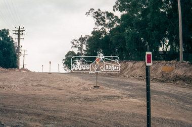
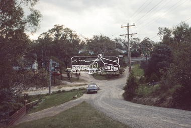
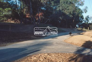
Slide, Quinn Estate from Sackville Street looking west to 'T-bowl' near Main Road, Montmorency, c.Oct. 1980
One of a series of images of roads and infrastructure focussed on the Quinn Estate in Montmorency taken by Eltham Shire Council Planning and Engineering officers. They provide perspective of the changes in housing styles and road development that began sweeping in from the mid 1970s with increasing urbanisation of what was once more outlying suburbs and regions.35 mm colour positive transparency Mount - Kodak Kodachrome CardProcessed Oct 1980roads, housing estate, infrastructure, main road, montmorency, quinn estate, sackville street, t-bowl -
 Eltham District Historical Society Inc
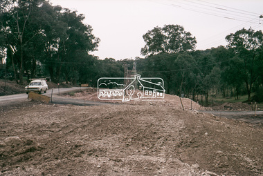
Slide, Quinn Estate, looking northeast along Sackville Street, Montmorency near no. 12, c.Oct. 1980
One of a series of images of roads and infrastructure focussed on the Quinn Estate in Montmorency taken by Eltham Shire Council Planning and Engineering officers. They provide perspective of the changes in housing styles and road development that began sweeping in from the mid 1970s with increasing urbanisation of what was once more outlying suburbs and regions.35 mm colour positive transparency Mount - Kodak Kodachrome CardProcessed Oct 1980infrastructure, housing estate, montmorency, quinn estate, roads, sackville street -
 Eltham District Historical Society Inc
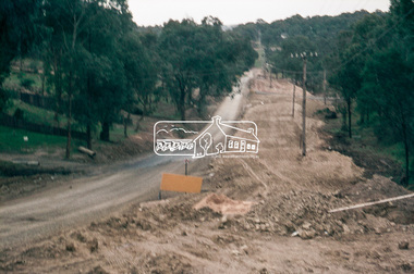
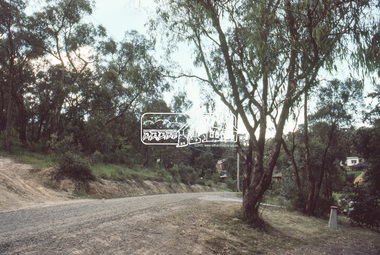
Slide, Sackville Street, Montmorency; split road near no. 36, c.Oct. 1980
One of a series of images of roads and infrastructure focussed on the Quinn Estate in Montmorency taken by Eltham Shire Council Planning and Engineering officers. They provide perspective of the changes in housing styles and road development that began sweeping in from the mid 1970s with increasing urbanisation of what was once more outlying suburbs and regions.35 mm colour positive transparency Mount - Kodak Kodachrome CardProcessed Oct 1980sackville street, infrastructure, montmorency, roads -
 Eltham District Historical Society Inc
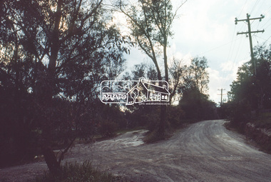
Slide, Quinn Estate looking east along Sackville Street just prior to Quinn Way, Montmorency, c.Oct. 1980
One of a series of images of roads and infrastructure focussed on the Quinn Estate in Montmorency taken by Eltham Shire Council Planning and Engineering officers. They provide perspective of the changes in housing styles and road development that began sweeping in from the mid 1970s with increasing urbanisation of what was once more outlying suburbs and regions.35 mm colour positive transparency Mount - Kodak Kodachrome CardProcessed Oct 1980roads, housing estate, infrastructure, montmorency, quinn estate, quinn way, sackville street -
 Eltham District Historical Society Inc
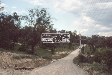
Slide, Quinn Estate near Sackville Reserve, Montmorency, c.Oct. 1980
One of a series of images of roads and infrastructure focussed on the Quinn Estate in Montmorency taken by Eltham Shire Council Planning and Engineering officers. They provide perspective of the changes in housing styles and road development that began sweeping in from the mid 1970s with increasing urbanisation of what was once more outlying suburbs and regions.35 mm colour positive transparency Mount - Kodak Kodachrome CardProcessed Oct 1980quinn estate, housing estate, infrastructure, montmorency, roads, sackville reserve, sackville street -
 Eltham District Historical Society Inc
Slide, Quinn Estate, Sackville Street, Montmorency, 15 Sep. 1982
One of a series of images of roads and infrastructure taken by Eltham Shire Council Planning and Engineering officers of the Quinn Estate in Montmorency, Stage 1, Private Street Scheme during construction, September 1982. They provide perspective of the changes in housing styles and road development that began sweeping in from the mid 1970s with increasing urbanisation of what was once more outlying suburbs and regions.35 mm colour positive transparency (1 of15) Mount - Kodak Kodachrome CardProcessed 15 Sep1980housing estate, infrastructure, montmorency, quinn estate, roads, sackville street, private street scheme -
 Eltham District Historical Society Inc
Slide, Quinn Estate, Sackville Street, Montmorency, 15 Sep. 1982
One of a series of images of roads and infrastructure taken by Eltham Shire Council Planning and Engineering officers of the Quinn Estate in Montmorency, Stage 1, Private Street Scheme during construction, September 1982. They provide perspective of the changes in housing styles and road development that began sweeping in from the mid 1970s with increasing urbanisation of what was once more outlying suburbs and regions.35 mm colour positive transparency (1 of15) Mount - Kodak Kodachrome CardProcessed 15 Sep1980housing estate, infrastructure, montmorency, quinn estate, roads, private street scheme, sackville street, t-bowl -
 Eltham District Historical Society Inc
Slide, Quinn Estate, Sackville Street, Montmorency, May 1983
One of a series of images of roads and infrastructure taken by Eltham Shire Council Planning and Engineering officers, May 1983 specifically looking at Private Street Schemes post road construction/sealing operations35 mm colour positive transparency (1 of 21) Mount - Kodak Kodachrome Cardroads, infrastructure, road sealing, footpaths and gutters, private street scheme, housing estate, montmorency, quinn estate, quinn way, sackville street -
 Eltham District Historical Society Inc
Slide, Quinn Estate, Sackville Street, Montmorency, May 1983
One of a series of images of roads and infrastructure taken by Eltham Shire Council Planning and Engineering officers, May 1983 specifically looking at Private Street Schemes post road construction/sealing operations35 mm colour positive transparency (1 of 21) Mount - Kodak Kodachrome Cardroads, infrastructure, road sealing, footpaths and gutters, private street scheme, housing estate, montmorency, quinn estate, sackville street, t-bowl -
 Eltham District Historical Society Inc
Slide, Quinn Estate, Sackville Street, Montmorency, May 1983
One of a series of images of roads and infrastructure taken by Eltham Shire Council Planning and Engineering officers, May 1983 specifically looking at Private Street Schemes post road construction/sealing operations35 mm colour positive transparency (1 of 21) Mount - Kodak Kodachrome Cardroads, infrastructure, road sealing, footpaths and gutters, private street scheme, housing estate, montmorency, quinn estate, sackville reserve, sackville street -
 Eltham District Historical Society Inc
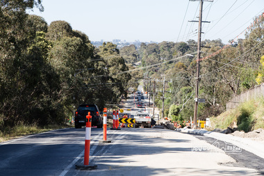
Photograph, Peter Pidgeon, Looking south towards Sackville Street, Bolton Street upgrade, Eltham, 13 November, 2017, 13/11/2017
North bound lane closure. Born Digitalbolton street, bolton street upgrade, eltham, streets, sackville street -
 Eltham District Historical Society Inc
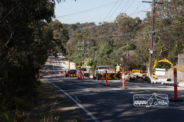
Photograph, Peter Pidgeon, Intersection with Sackville Street, Bolton Street upgrade, Eltham, 13 November, 2017, 13/11/2017
North bound lane closure. Born Digitalbolton street, bolton street upgrade, eltham, streets, sackville street -
 Port Fairy Historical Society Museum and Archives
Photograph
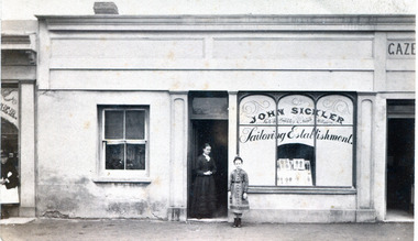
Tailor's shop next door to the Port Fairy Gazette Office (local newspaper office) in Sackville Street owned by John Sickler and later W. georgeBlack and white photograph of shop front with arched windows on right hand side and a female and a young girl standing in the doorwaytailor shop, commercial enterprise, shop, store, sackville street -
 Port Fairy Historical Society Museum and Archives
Photograph
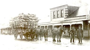
Jim Bragg and Alec Watson carting wool probably from Alec Watson's property "Grasslands" to the port for shipping. This photograph was taken in Sackville Street in front of Cheapside Warehouseblack and white photograph of a wagon load of wool being transported to wharftransport, rail, road, alec watson, grasslands, shipping, sackville street, jim bragg, property, wagon, horses, cargo, wool, wool bales, cheapside warehouse -
 Port Fairy Historical Society Museum and Archives
Photograph
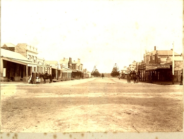
Sackville Street Port Fairy Black and white photograph of Sackville Street in Port Fairy maybe late 1800’s -early 1900’ssackville street, port fairy, town, hosking, carter, shops, earle, printer, bootmaker -
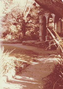
 Kew Historical Society Inc
Photograph - 'La Verna', (formerly 'Heathfield'), Sackville Street, 1979
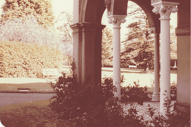
In 1979, a series of photographs of significant gardens in Kew (Victoria) were taken during a tour by Peter Watts, Historic Gardens Coordinator of National Trust Victoria. These were later purchased to add to the collection. In the case of each photo the colour had badly degraded over time. Original colour (degraded) positive photograph of 'La Verna', (formerly 'Heathfield'), Sackville Street , Kew.Annotated in ink on reverse: "Laverna Retreat Sackville St / View of sweeping rows of trees, lawn through portico / Purchased by Society Oct 1979."gardens -- kew (vic.), heathfield, la verna, sackville street -- kew (vic.) -
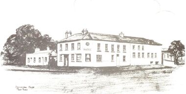
 Port Fairy Historical Society Museum and Archives
Photograph
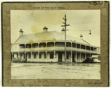
Iconic Hotel in Port Fairy Built as the first of a proposed chain of hotels by John Walwyn Taylor in 1855 on the corner of Bank and Sackville Streets. 2 stories with a balcony wrapping around 2 sides of the building. The site was formerly occupied by the wooden hotel "The Sally Ann". A snapshot of time showing the hotel the power lines, and the style of cars from that era.Black and white photograph of the Star of the West Hotel on a brown bordered mountWritten in Pen at top and underlined - STAR OF THE WEST HOTEL Lower right - ball point pen museum numbers 62.04B.011D On Back- Pencil - 3-17 - S2-7-57 - j o h 2-7-57john walwyn taylor, the sally ann, bank street, sackville street, hotel, star of the west -
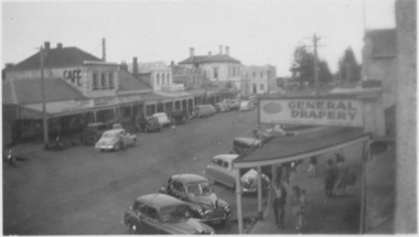 Port Fairy Historical Society Museum and Archives
Photograph
Centre of Sackville Street possible dates 1940’s-50’sBlack and white photograph of centre of Sackville street with general Drapery sign on right and cafe sign on building on the leftstreet, town, sackville st, cars, drapery, cafe -
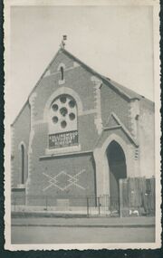
 Uniting Church Archives - Synod of Victoria
Photograph, undated
The Gipps Street Wesleyan Methodist Church of 1874 and the adjoining school hall, were built in the Collingwood Flat area - one of the municipality's poorest areas. In 1903, the Collingwood Methodist Mission was established with its headquarters in the Gipps Street Church. Six Methodist Missions were created in inner Melbourne. Three churches were operated by the Collingwood Mission. They were: Sackville Street Collingwood, Elizabeth Street, North Richmond (demolished), and Gipps Street Collingwood (demolished). The Mission operated until approximately 1930. The Wesleyan Church and School in Sackville St. Collingwood was built in 1886 and used as a church for 65 years. It was also part of the Collingwood Methodist Mission before being converted to an industrial/commercial complex. The church was auctioned on 3 March 1984.B & W exterior view of the Sackville St. Collingwood Methodist Mission. gipps st. methodist church, les gorrie, collingwood mission, sackville street church, wesleyan -
 Kew Historical Society Inc
Photograph - 'Merridale' (formerly 'Pomeroy'), 43 Sackville Street, 1979
In 1979, a series of photographs of significant gardens in Kew (Victoria) were taken during a tour by Peter Watts, of National Trust Victoria. These were later purchased to add to the collection. In the case of each photo the colour had badly degraded over time. Original colour (degraded) positive photograph of the front garden and part of the colonnaded verandah of 'Merridale' (formerly 'Pomeroy'), 43 Sackville Street, Kew.Annotated in ink reverse: "Merridale 43 Sackville St Built 1884/5 / View of drive to portico / Entrance old trees and gardens"merridale, pomeroy, sackville street -- kew (vic.), gardens -- kew (vic.) -
 Port Fairy Historical Society Museum and Archives
Drawing - Post Card, Stag Hotel
This is one of a series of post cards drawn by artist Mrs Irene Bartlett of Port Fairy. This one depicts the Stag Hotel on the corner of Cox Street and Sackville Street. Now known as Seacombe Houseblack and white drawing of the Stag Hotel and Cottages drawn showing Sackville and Cox street aspects to be used as a post cardStag Hotelhotel, sketch, i.bartlett, post card, sackville street, cox street, seacombe house, stag inn, irene bartlett, stag hotel -
 Uniting Church Archives - Synod of Victoria
Photograph - Newspaper cutting, 2 March 1984
The Gipps Street Wesleyan Methodist Church of 1874 and the adjoining school hall, were built in the Collingwood Flat area - one of the municipality's poorest areas. In 1903, the Collingwood Methodist Mission was established with its headquarters in the Gipps Street Church. Six Methodist Missions were created in inner Melbourne. Three churches were operated by the Collingwood Mission. They were: Sackville Street Collingwood, Elizabeth Street, North Richmond (demolished), and Gipps Street Collingwood (demolished). The Mission operated until approximately 1930. The Wesleyan Church and School in Sackville St. Collingwood was built in 1886 and used as a church for 65 years. It was also part of the Collingwood Methodist Mission before being converted to an industrial/commercial complex. The church was auctioned on 3 March 1984.The cutting gives information about the history of the Church at 25 Sackville St. Collingwood prior to its auction sale on 3 March 1984gipps st. methodist church, les gorrie, collingwood mission, sackville street church, wesleyan -
 Warrnambool and District Historical Society Inc.
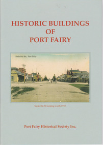
Booklet, Port Fairy Historical Society, Historic Buildings of Port Fairy, 2012
Port Fairy, a small town in Western Victoria established in 1836, has an exceptional collection of public buildings and dwellings dating from the 1840s. This booklet gives short descriptions of 58 of these historic buildings, many with accompanying photographs. These include many buildings in Gipps and Sackville Streets, the Powder Magazine, some hotels, the Drill Hall, Dublin House, the Port Fairy Cemetery and several schools and churches. This booklet is useful for those seeking quick information on the historic buildings in Port Fairy and for those wanting to undertake a walk around the town’s historic spots. TryBooking will show you the full breakdown on the Booking Payment Report and the Event Revenue Itemised Report so you can clearly see the ticket sales, credit card processing fee and the funds that are yours. Front cover: ‘Historic Buildings of Port Fairy, Port Fairy Historical Society Inc.’ Photograph on front cover: ‘Sackville Str. Port Fairy’, ‘Sackville St. looking south 1910’ Back cover map: ‘Port Fairy Historic Buildings’ warrnambool, port fairy, western victoria, historic buildings -
 Kew Historical Society Inc
Photograph - Preshil (formerly 'Blackhall'), 26 Sackville Street, 1988
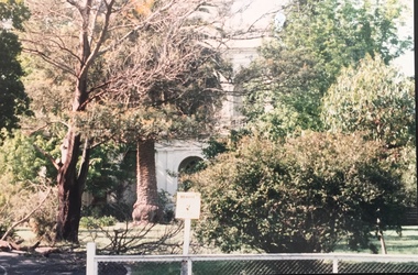
This grand Italianate mansion at 26 Sackville Street was built in 1890 as a private home. In May 1915, ‘Blackhall’ was purchased for £1800 by the Salvation Army and renamed the ‘Catherine Booth Girls’ Home’. The Home provided accommodation from 1915 to 1976 for about 90 to 100 girls between the ages of 4 and 16. An original plaque can still be seen at the front entrance. ‘Preshil, the Margaret Lyttle Memorial School’ purchased Blackhall for its Senior School in 1978. The photograph dates from 1945.Colour photographic positive of one of the houses in Sackville Street, now Preshil but formerly 'Blackhall'. Also at one stage the Salvation Army Catherine Booth Girls’ Home. Built in 1890, Blackhall is of significance as a typical and intact late Victorian mansion and as such is one of the key Victorian Buildings to have been built in Kew. It is integral to the significance of the concentration of Victorian mansions along Sackville Street.blackhall -- sackville street -- kew (vic.), catherine booth girls’ home, salvation army -- kew (vic.) -
 Port Fairy Historical Society Museum and Archives
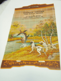
Tool - Calendar
This item was bought by Lynda Tieman for the Port Fairy Historical Society. It represents a time in in Port Fairy when there were several butchers in the town and competition for customers was fierce. Norman Collins butchers was situated in Sackville Street where a dress shop now occupies the site.An advertising piece that places Norman Collins as butcher in 47 Sackville Street and a rare example of this type of advertising.Bamboo, advertising,give away calendar with green ribbon hanger for Port Fairy butcher (calendar removed). Printed with rural scene of ducks and hunting dogs. Bamboo slats are joined by thread and the ribbon is attached to the top of the calendar for hanging. Calendar itself has been removed.With Compliments from Norman Collins Your Quality Butcher 47 Sackville Street, Port Fairy, Phone 56 For Friendly Service and Free Deliverybutcher, advertising, business, collins, sackville street, norman collins, calendar -
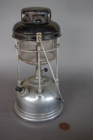 Upper Yarra Museum
Lamp, Tilley Lamp Company
http://en.wikipedia.org/wiki/File:Tilley-storm-lantern-X246-May- Tilley storm lantern, this model has been in production since 1964 The Tilley Lamp derives from John Tilley’s invention of the hydro-pneumatic blowpipe in 1813 in England. http://en.wikipedia.org/wiki/Kerosene_lamp#Pressure_lamp Pressure lamps are far more sophisticated than wick lamps and produce a much brighter light, although they can be quite complicated and fiddly to use. This type of lamp is commonly known in the UK as a "Tilley lamp", after a manufacturer of the same name, and in North America as a "Coleman lantern" for similar reasons. A kerosene blowtorch displaying the various aspects of the kerosene burnerA pressure lamp has a fuel tank at the bottom with a small pump to pressurise the kerosene. There is a narrow gap up to the top of the lamp, called a flue, and at the top of the lamp there is a burner (gas outlet). Directly underneath the burner is the mantle, a fabric bag coated with chemicals that incandesce when heated by the gas flame. The burner lamp is known for its brightness. It is so bright because of the amount of pressure that is placed onto the wick. This pressure allows a steady flow of the gasoline and a constant light Tilley Storm Pressure Lantern, model no x246 has a stainless steel base which is filled with kerosene, with a pump used to pressurize the kerosene vapor. Under the base is a sticker.On top is a black hood with vents which sits on the glass heat resistant shade. The glass shade has an etched label. It has a white and pink mantle on the central rod with a long shaped stainless steel handle, this folds down when not in use.Base - Sticker Tilley Lamp Model X246 Etched on glass shade Tilley, Durosil, ITI, Heat Resistant. Made in Englandlantern tilley pump pressure mantle kerosene methylated spirits stainless steel lamp kerosene lamp round glass cylinder