Showing 1094 items matching "scottish hills"
-
 Flagstaff Hill Maritime Museum and Village
Postcard
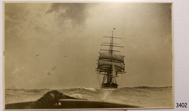
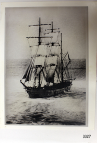
... ...scottish hills...Back and White postcard of the sailing ship Scottish Hills. (SH 275 Ships S)...Flagstaff Hill Maritime Museum and Village 89 Merri Street Warrnambool great-ocean-road flagstaff hill warrnambool shipwrecked-coast flagstaff-hill flagstaff-hill-maritime-museum maritime-museum shipwreck-coast flagstaff-hill-maritime-village post card scottish hills postcard sailing ship Postcard Back and White postcard of the sailing ship Scottish Hills. ...Back and White postcard of the sailing ship Scottish Hills. (SH 275 Ships S)flagstaff hill, warrnambool, shipwrecked-coast, flagstaff-hill, flagstaff-hill-maritime-museum, maritime-museum, shipwreck-coast, flagstaff-hill-maritime-village, post card, scottish hills, postcard, sailing ship, postcard -
 Box Hill Historical Society
Photograph - Box Hill Scottish Dancers, 1/08/1976
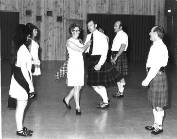
... Box Hill Scottish Dancer performing at the opening of the Community Centre at 17 Bank Street, Box Hill, in August 1976...Box Hill Scottish Dancer performing at the opening of the Community Centre at 17 Bank Street, Box Hill, in August 1976 Box Hill Scottish Dancers Box Hill Community Centre Dancers Dancing b&w photo Photograph Box Hill Scottish Dancers ...Box Hill Scottish Dancer performing at the opening of the Community Centre at 17 Bank Street, Box Hill, in August 1976b&w photobox hill scottish dancers, box hill community centre, dancers, dancing -
 Surrey Hills Historical Society Collection
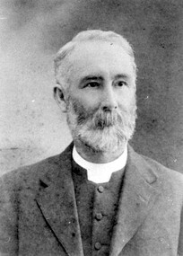
Work on paper - Photograph, Rev Alex MacDonald, c1909
... Hill, Vic. : 1889 - 1925) Fri 16 Dec 1910, Page 4 - New Church at Surrey. 2. Index of Ministers who served in the Presbyterian Church of Victoria: b. 1853 Scotland; Edinburgh Free Church; 1880 ordained Wangaratta, Vic.; 1890 demitted, returned to Scotland; 1892 Surrey Hills; Deepdene, helped organise Church; 1936 died. ...Hill, Vic. : 1889 - 1925) Fri 16 Dec 1910, Page 4 - New Church at Surrey. 2. Index of Ministers who served in the Presbyterian Church of Victoria: b. 1853 Scotland; Edinburgh Free Church; 1880 ordained Wangaratta, Vic.; 1890 demitted, returned to Scotland; 1892 Surrey Hills; Deepdene, helped organise Church; 1936 died. ...Rev Alex MacDonald was the minister at St Stephen's Presbyterian Church, Surrey Hills. He laid the foundation stone of the new church on 2 July 1910. He gave the sermon when the church was officially dedicated in December the same year. REF: 1.TROVE - The Reporter (Box Hill, Vic. : 1889 - 1925) Fri 16 Dec 1910, Page 4 - New Church at Surrey. 2. Index of Ministers who served in the Presbyterian Church of Victoria: b. 1853 Scotland; Edinburgh Free Church; 1880 ordained Wangaratta, Vic.; 1890 demitted, returned to Scotland; 1892 Surrey Hills; Deepdene, helped organise Church; 1936 died. https://illuminate.recollect.net.au/nodes/view/16616 3. Transcript Boroondara Cemetery - buried with his sister; graves 1958 & 1959; died 24 July 1936 4. Electoral rolls: 1914 & 1919 - living at 16 Canterbury Road, Camberwell with Jane Smith Mackie and Mary McMillan Black and white head and shoulders portrait of a bearded gentleman in clerical clothing. presbyterian church, (rev) alexander macdonald, st stephen's presbyterian church -
 Warrnambool and District Historical Society Inc.
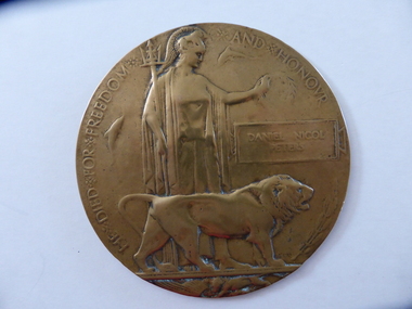
Medallion, Dead Man's Penny Daniel Nicol Peters, C 1919
... This medallion was to commemorate Daniel Nicol Peters who came from Scotland but enlisted in the AIF in Blackboy Hill Western Australia. ...This medallion was to commemorate Daniel Nicol Peters who came from Scotland but enlisted in the AIF in Blackboy Hill Western Australia. ...The dead man's penny is a commemorative medallion which was presented to the family of soldier s who were killed in the First World War. The images of Brittania the dolphins and the lion represent Brittain and the eagle represents Germany. The name of the soldier is presented without rank to signify the equality of all sacrifice. This medallion was to commemorate Daniel Nicol Peters who came from Scotland but enlisted in the AIF in Blackboy Hill Western Australia. His regimental number was 3200. he was Killed in Action on 26 August 1918. His father was John Peters of Greenside Fifeshire Scotland. From a country with a population of approximately 5 million people, there were more than 60000 soldiers killed. This object represents but one of these soldiers. It therefore has historical and social significanceCircluar brass plaque with figure of Brittania and a lion in low relief. There are two dolphins around the figure of Brittania and and image of a defeated eagle below the lion.To the right of the figure is a small rectangle with the name of the soldier. Text around the edge.He died for freedom and honour. Daniel Nicol Petersdead man's penny, daniel nicol peters -
 Emerald Museum & Nobelius Heritage Park
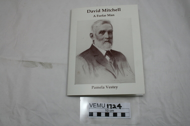
Book, David Mitchell, A Forfar Man by Pamela Vestey, 2014
... David Mitchell was born near the town of Forfar, Scotland, became an apprentice to a stone mason and builder, then emigrated to Australia in 1853. In Melbourne, he set up a builder's yard in Burnley St, Richmond and later bought Cave Hill Limestone Quarries in Lilydale and manufactured the cement in Richmond. ...Emerald Museum & Nobelius Heritage Park 5 Crichton Rd Emerald yarra-valley-and-the-dandenong-ranges David Mitchell was born near the town of Forfar, Scotland, became an apprentice to a stone mason and builder, then emigrated to Australia in 1853. In Melbourne, he set up a builder's yard in Burnley St, Richmond and later bought Cave Hill Limestone Quarries in Lilydale and manufactured the cement in Richmond. ...David Mitchell was born near the town of Forfar, Scotland, became an apprentice to a stone mason and builder, then emigrated to Australia in 1853. In Melbourne, he set up a builder's yard in Burnley St, Richmond and later bought Cave Hill Limestone Quarries in Lilydale and manufactured the cement in Richmond. He became Shire President for Lillydale in 1883. Also he established a brickworks in Burnley St, Richmond. He was responsible for building PLC College in East Melbourne, Menzies Hotel, The Exhibition building and Scots Church. Although he was very wealthy in his own right, he is also known as the father of Dame Nellie Melba. White soft cover booklet with a large drawing of David Mitchell (1901) on the front. -
 Flagstaff Hill Maritime Museum and Village
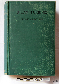
Book - Reference, William J Goudie, D. Sc., Professor (William john Goudie), Steam Turbines, 1922
... Hill Maritime Museum and Village...Warrnambool...Maritime Museum...Maritime Village...Great Ocean Road...Shipwreck Coast...steam turbines...Longmans Green and Co...Paternoster Row London...ship logo...engineering studies...textbook...1922...Longmans Green and Co....L & Co....1724...Institution of Mechanical Engineers...Institution of Engineers and Shipbuilders Scotland...Flagstaff Hill Maritime Museum and Village 89 Merri Street Warrnambool great-ocean-road This textbook was written for engineering students by Scottish Professor, William J Goudie, D. ...This textbook was written for engineering students by Scottish Professor, William J Goudie, D. Sc., (1868-1945). He was a member of the Institution of Mechanical Engineers, a member of the Institution of Engineers and Shipbuilders in Scotland, an Associate Member of the Institution of Civil Engineers, James Watt Chair of Mechanical Engineering, University of Glasgow, and Professor of "The Theory and practice of Heat Engines" in the University of Glasgow. He wrote several papers and books on the topics of mechanical speed and power. The publisher firm, Longmans, Green & Co., was originally founded in 1724 in London by Thomas Longman under the name Longman. In August of that year, he bought the two shops and goods of William Taylor and set up his publishing house there at 39 Paternoster Row. The shops were called Black Swan and Ship, and it is said that the 'ship' sign was the inspiration for Longman's Logo. After many changes of name and management, the firm was incorporated in 1926 as Longmans, Green & Co. Pty Ltd. The firm was acquired by Pearson in 1968 and was known as Pearson Longman or Pearson PLC. The first practical steam turbine was built in 1884 by Charles Parsons and this became the beginning of generating electricity and powering large ships. The author of Steam Turbines, Professor William John Couldie D. Sc, was a mechanical engineer who had practical experience in a marine consulting engineering service and lectured in the theory and practice of mechanical engineering.This book is an example of the development of technology that contributed to the evolution of steam turbines. The book is also significant for its connection to the publisher Longmans, Green and Co., of London, a firm that has been established for over two centuries, renowned for publishing encyclopedias, dictionaries, books on English grammar, textbooks, poetry, reference books, novels, magazines and more.Steam Turbines, by William J. Goudie, D. Sc., Second edition, rewritten and enlarged. Published by Longmans, Green & Co. in 1922. The book has a textured green hardcover with a printed black title on the front cover and a gold embossed title on the spine. The fly page describes the contents. It states the author's credentials and the book's features - 329 illustrations and numerous examples.. The logo of Longmans, Green & Co. is on the fly page. It is a line drawing of a shield above a leafy wreath border surrounding a sailing ship at sea with a plaque below. Inscriptions are on the shield and plaque.On the shield: "L & Co" [Longman Green & Co.] On the plaque: "1724" [date business was established]flagstaff hill, flagstaff hill maritime museum and village, warrnambool, maritime museum, maritime village, great ocean road, shipwreck coast, steam turbines, longmans green and co, paternoster row london, ship logo, engineering studies, textbook, 1922, longmans green and co., l & co., 1724, institution of mechanical engineers, institution of engineers and shipbuilders scotland, institution of civil engineers, james watt professor of "the theory and practice of heat engines", thomas longman, paternoster row, william goudie, william j goudie, professor william j goudie d. sc., james watt chair of mechanical engineering, steam turbine, marine turbines, steam power -
 Flagstaff Hill Maritime Museum and Village
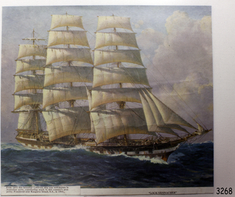
Print - Vessel, Sailing Ship, Loch Vennacher, 1875
... Flagstaff Hill Maritime Museum and Village 89 Merri Street Warrnambool great-ocean-road This print shows an image of the three-masted iron clipper Loch Vennachar. The ship was built by Thomson’s on the Clyde under the Glasgow Shipping Co in 1875 and named after a Scottish lake, as were other ships in the Loch Line’s fleet. ...This print shows an image of the three-masted iron clipper Loch Vennachar. The ship was built by Thomson’s on the Clyde under the Glasgow Shipping Co in 1875 and named after a Scottish lake, as were other ships in the Loch Line’s fleet. Loch Vennachar made many journeys from Britain to Australia and was well-known in Australian ports. On one of its homeward-bound journeys from Australia, the ship sank in the River Thames. Its cargo included 850 tonnes of preserved canned rabbits from Warrnambool's Western Meat Preserving Company. The ship was raised and continued trading for another four years. On 14th June 1905, Loch Vennachar departed Glasgow for Adelaide and Melbourne. The last known sighting of it was on 6th September 1875 when overtaken by the SS Yongala; the captains exchanged the “all well” signals. After that, the ship disappeared with loss of all 27 lives, according to a list that was received by Fremantle through the English mail. The list indicated that there were no passengers on that voyage. Sadly, other Loch Line ships med with similar disasters. The list of lost crew on the Loch Vennachar included Thomas. W. Pearce, apprentice, Southampton. His father was Tom Pearce, one of the two survivors of the Loch Ard, wrecked in 1878. Also, Thomas’ grandfather, James Pearce, was the captain of SS Gothenburg at the time of her wrecking in 1875. Consequently, the wrecking of the Loch Vennachar and the Loc Sloy near the southwest point of Kangaroo Island, a lighthouse was erected, officially opening in June 1907. The northern headland of West Bay was named Vennachar Point in memory of the ship in 1908. The wreck was discovered in 1976 by divers from the Society for Underwater Historical Research, over seventy years after being lost off Kangaroo Island.The Loch Vennachar performed a significant role in Australia’s colonial trade, taking goods between Great Britain and Australia. These goods included locally preserved tinned rabbits processed at a factory in Warrnambool for overseas trade.Coloured print from a painting of the sailing ship Loch Vennachar in full sail on the sea. The ship was built in 1875 and wrecked in 1905 off Kangaroo Island.Text under print "Loch Vennacher" and "from 1875 this beautiful 1,400 ton ship was well-known in Australian ports, contributing much to this country's prosperity. Foundered near Kangaroo Island, S.A., in 1905." flagstaff hill, warrnambool, shipwrecked-coast, flagstaff-hill, flagstaff-hill-maritime-museum, maritime-museum, shipwreck-coast, flagstaff-hill-maritime-village, loch vennachar, loch vennacher, loch line ship, glasgow shipping co, 1975 clipper ship, loch vennachar image., kangaroo island shipwreck, 1905 shipwreck, tinned rabbits, preserved rabbits, western meat preserving company, 1901, 1905 -
 Flagstaff Hill Maritime Museum and Village
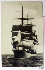
Postcard - Ship, Monkbarns, ca. 1924
... Flagstaff Hill Maritime Museum and Village 89 Merri Street Warrnambool great-ocean-road This photograph of the Monkbarns was taken prior to 1927 before the sailing ship was converted for use as a hulk. The steel-hulled, 3-masted fully rigged ship was built in 1895 by Archibald McMillan & Son at Dumbarton in Scotland. ...This photograph of the Monkbarns was taken prior to 1927 before the sailing ship was converted for use as a hulk. The steel-hulled, 3-masted fully rigged ship was built in 1895 by Archibald McMillan & Son at Dumbarton in Scotland. It was 267 feet long, 40.1 feet wide and 23.5 feet deep. In 1914 John Stewart & Co. owned ten sailing vessels, one of which was the Monkbarns, but by the end of the first World War, the fleet had only four vessels survived the war, including the Monkbarns. The Monkbarns traded across the world. Some of the destinations included Port Adelaide, Table Bay in South Africa, Liverpool, Sydney, London and New York. Her last commercial voyage was in 1926. Overall, the ship traded for 32 years before it was converted in Spain in 1927 for use as a hulk for carrying coal. There were several owners of the ship over its lifetime. They were - 1895, first owner, Charles Webster Corsar, Liverpool - 1902, the owner was D. Corsar & Son, Liverpool - 1909, owned by John Hardie & Sons, Glasgow - 1911, John Stewart & Co., Liverpool - by1915, James A. Young, London - 1926, L.H. Wilson, Liverpool - 1927, Ballener Espando (Brunn & van Lippe, Tonsberg).The postcard shows and example of the sailing ships that traded across the seas and into Australia in the late 19th and early 20th century.Black and white postcard of a sailing ship, fully rigged, at sea. Handwritten on front of card is "Monkbarns"Handwritten on front "MONKBARNS". monkbarns, postcard, sailing ship, flagstaff hill, warrnambool, maritime village, maritime museum, flagstaff hill maritime museum & village, shipwreck coast, great ocean road, newccastle, hulk -
 Flagstaff Hill Maritime Museum and Village
Photograph, post 1889
... Flagstaff Hill Maritime Museum and Village 89 Merri Street Warrnambool great-ocean-road The photograph shows the three-masted iron and steel bark "Newfield" sailing in open seas. It event would have been between 1889-1892 during the ship's working life. ABOUT THE NEWFIELD The Newfield was a three-masted iron and steel barque, built in Dundee, Scotland ...The photograph shows the three-masted iron and steel bark "Newfield" sailing in open seas. It event would have been between 1889-1892 during the ship's working life. ABOUT THE NEWFIELD The Newfield was a three-masted iron and steel barque, built in Dundee, Scotland, in 1889 by Alexander Stephen and Sons. It was owned by the Newfield Ship Company in 1890 and later that year It was registered in Liverpool to owners Brownells and Co. The Newfield left Sharpness, Scotland, on 28th May 1892 with a crew of 25 under the command of Captain George Scott and on 1st June left Liverpool. She was bound for Brisbane, Australia, with a cargo of 1850 tons of fine rock salt, the main export product of Sharpness. At about 9pm on 28th August 1892, in heavy weather, Captain Scott sighted, between heavy squalls, the Cape Otway light on the mainland of Victoria but, due to a navigational error (the ship’s chronometers were wrong), he assumed it to be the Cape Wickham light on King Island, some 40 miles south. He altered his course to the north, expecting to enter Bass Strait. The ship was now heading straight for the south west Victorian coast and at about 1:30am ran aground on a reef about 100 yards from shore and one mile east of Curdie’s Inlet, Peterborough. The ship struck heavily three times before grounding on an inner shoal with 6 feet of water in the holds. Rough sea made the job of launching lifeboats very difficult. The first two lifeboats launched by the crew were smashed against the side of the ship and some men were crushed or swept away. The third lifeboat brought eight men to shore. It capsized when the crew tried to return it to the ship for further rescue The Port Campbell rocket crew arrived and fired four rocket lines, none of which connected with the ship. A local man, Peter Carmody, volunteered to swim one mile to the ship with a line to guide the fourth and final lifeboat safely to shore. Seventeen men survived the shipwreck but the captain and eight of his crew perished. One of the men, apprentice William McLeod, was rescued by local woman Margaret E. MacKenzie. The Newfield remained upright on the reef with sails set for a considerable time as the wind slowly ripped the canvas to shreds and the sea battered the hull to pieces. The Marine Board inquiry found the wreck was caused by a "one man style of navigation" and that the Captain had not heeded the advice of his crew. According to Jack Loney ‘… when the drama was over . . the Newfield was deserted except for the Captain’s dog and two pigs.’ Flagstaff Hill Maritime Museum has several artefacts that have been salvaged from the wreck. The report from SHP documented the following in regards to the Newfield collection: Flagstaff Hill’s collection of artefacts from the Newfield is of historical and archaeological significance at a State level, because of its association with the shipwreck, which is on the Victorian Heritage Register. The collection is significant because of its relationship between the objects. The Newfield collection is archaeologically significant as it is the remains of an international cargo ship. The Newfield collection is historically significant for representing aspects of Victoria’s shipping history and its potential to interpret sub-theme 1.5 (Living with natural processes). The collection is also historically significant for its association with the shipwreck. Black and white photograph of the three-masted sailing ship “Newfield” in the open sea, sails unfurled. The ship was built in 1859 by Alexander Stephen and Sons Limited of Dundee, Scotland. flagstaff hill, warrnambool, shipwrecked-coast, flagstaff-hill, flagstaff-hill-maritime-museum, maritime-museum, shipwreck-coast, flagstaff-hill-maritime-village, barque newfield, photograph, 1880s sailing ship -
 Flagstaff Hill Maritime Museum and Village
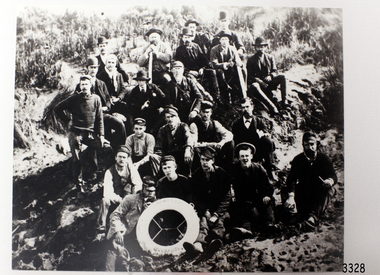
Photograph - Ship Crew, 1889-1892
... Hill Maritime Museum and Village 89 Merri Street Warrnambool great-ocean-road This black and white photograph shows the crew of the barque Newfield. They are pictured seated on a grassy slope and rock, a lifebuoy from the Newfield, Liverpool, resting on the men in the front row. The men are formally dressed, some with bowler hats, a bow tie and pipe, rather than in their sailing uniforms. ABOUT THE NEWFIELD The Newfield left Sharpness, Scotland ...This black and white photograph shows the crew of the barque Newfield. They are pictured seated on a grassy slope and rock, a lifebuoy from the Newfield, Liverpool, resting on the men in the front row. The men are formally dressed, some with bowler hats, a bow tie and pipe, rather than in their sailing uniforms. ABOUT THE NEWFIELD The Newfield left Sharpness, Scotland, on 28th May 1892 with a crew of 25 under the command of Captain George Scott and on 1st June left Liverpool. She was bound for Brisbane, Australia, with a cargo of 1850 tons of fine rock salt, the main export product of Sharpness. At about 9pm on 28th August 1892, in heavy weather, Captain Scott sighted, between heavy squalls, the Cape Otway light on the mainland of Victoria but, due to a navigational error (the ship’s chronometers were wrong), he assumed it to be the Cape Wickham light on King Island, some 40 miles south. He altered his course to the north, expecting to enter Bass Strait. The ship was now heading straight for the south west Victorian coast. At about 1:30am the Newfield ran aground on a reef about 100 yards from shore and one mile east of Curdie’s Inlet, Peterborough. The ship struck heavily three times before grounding on an inner shoal with 6 feet of water in the holds. Rough sea made the job of launching lifeboats very difficult. The first two lifeboats launched by the crew were smashed against the side of the ship and some men were crushed or swept away. The third lifeboat brought eight men to shore. It capsized when the crew tried to return it to the ship for further rescue The rescue was a difficult operation. The Port Campbell Rocket Crew arrived and fired four rocket lines, none of which connected with the ship. Peter Carmody, a local man, volunteered to swim about one mile off shore to the ship with a line to guide the fourth and final lifeboat safely to shore. He was assisted by James McKenzie and Gerard Irvine. Seventeen men survived the shipwreck but the captain and eight of his crew perished. The Newfield remained upright on the reef with sails set for a considerable time as the wind slowly ripped the canvas to shreds and the sea battered the hull to pieces. The Marine Board inquiry found the wreck was caused by a "one man style of navigation" and that the Captain had not heeded the advice of his crew. According to Jack Loney ‘… when the drama was over . . the Newfield was deserted except for the Captain’s dog and two pigs.’ Peter Carmody was awarded the Bramley Moore medal by the Liverpool Shipwreck and Humane Society for Saving Life at Ssea, which he received by mail on January 21st 1893. Flagstaff Hill’s collection of artefacts from the Newfield is significant for its association with the shipwreck Newfield, which is listed on the Victorian Heritage Registry. The collection is significant because of the relationship between the objects. The Newfield collection is archaeologically significant as the remains of an international cargo ship. The Newfield collection is historically significant for representing aspects of Victoria’s shipping history and its association with the shipwreck. The Letter accompanying the Medal for Bravery awarded to Peter Carmody is significant because the attempt to save lives is associated with the shipwreck Newfield. Black and white photograph of the crew of the sailing ship “Newfield”. The men in formal dress are seated on rocky slope with the ship’s lifebuoy showing the name “NEWFIELD, LIVERPOOL”. Photograph taken 1889-1892 flagstaff hill, warrnambool, shipwrecked-coast, flagstaff-hill, flagstaff-hill-maritime-museum, maritime-museum, shipwreck-coast, flagstaff-hill-maritime-village, newfield, photograph, crew of the newfield, 19th century sailing ship, peterborough, cape otway, medal for bravery -
 Eltham District Historical Society Inc
Document - Folder, Panton, Joseph Anderson
... Scotland to Australia in 1851. In Bendigo, he was appointed assistant gold commissioner 1852 and senior commissioner 1854. Over the years, he served as magistrate at Jamieson-Wood's Point, Anderson's Creek, Heidelberg, Geelong and Melbourne. He owned land on the Yarra River and Panton Hill...Scotland to Australia in 1851. In Bendigo, he was appointed assistant gold commissioner 1852 and senior commissioner 1854. Over the years, he served as magistrate at Jamieson-Wood's Point, Anderson's Creek, Heidelberg, Geelong and Melbourne. He owned land on the Yarra River and Panton Hill ...Joseph Anderson Panton (1831-1913) came from Scotland to Australia in 1851. In Bendigo, he was appointed assistant gold commissioner 1852 and senior commissioner 1854. Over the years, he served as magistrate at Jamieson-Wood's Point, Anderson's Creek, Heidelberg, Geelong and Melbourne. He owned land on the Yarra River and Panton Hill is named for him. Contents Map: J A Panton's landholding with surrounding landholders. Printout and photocopy: Panton, Joseph Anderson, Australian Dictionary of Biography entry. Notes: Joseph Anderson Panton, brief biographical notes. Research Enquiry Form: Vivienne Worthington, seeking sources of information regarding Joseph Anderson Panton, 14 June 2017. Email and associated documents: Michael Kennedy seeking assistance of Eltham Gateway Action Group regarding proposed felling of manna gum tree near bridge across Diamond Creek, on land once held by Joseph Anderson Panton. Newspaper article: "Historic painting might be lost to Victoria," The Age, 22 October 1985. Painting by Joseph Anderson Panton of Captain William Lonsdale's house, Victoria's first Government House, to be in forthcoming auction. Newspaper clippings, A4 photocopies, etcjoseph anderson panton, william b burnley, w walsh, r hall, r a davidson, j orford, b speers, a speers, william bell, t baillie, d mcloughlin, t prior, g e hodgkins, n rodda, w r belcher, g d boursiquot, j p imley, t b darling, h g jones, t sweny, r lane, w gordon, a e morris, d w thring, j carfrae, thomas sweeney, michael kennedy, vivienne worthington, william crozier, j frank, p carrucan, panton hill -
 Eltham District Historical Society Inc
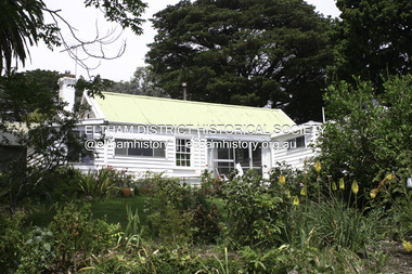
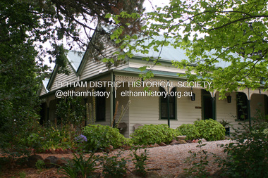
Photograph - Digital Photograph, Alan King, Garden Hill, Eltham-Yarra Glen Road, Kangaroo Ground, 3 February 2008
... Built by Scottish farmer Andrew Harkness who acquired the property in 1849 at the top of the hill with magnificent panoramic views as far as Kinglake, the same year he married Sarah Oswin. ...Built by Scottish farmer Andrew Harkness who acquired the property in 1849 at the top of the hill with magnificent panoramic views as far as Kinglake, the same year he married Sarah Oswin. ...The original house was built around 1850 was one of Kangaroo Ground's earliest homes, part of which remains today. Built by Scottish farmer Andrew Harkness who acquired the property in 1849 at the top of the hill with magnificent panoramic views as far as Kinglake, the same year he married Sarah Oswin. The property was known as Garden Hill from at least 1865. Andrew and Sarah had four sons and five daughters. Harkness was a founder of the Kangaroo Ground School and one of the first to suggest establishing the Eltham District Road Board (1858-71) of which he was a member, the pre-cursor to the Shire of Eltham (1871-1994). He was also a Trustee of the Kangaroo Ground Cemetery. His daughter Fanny married farmer Alexander White who purchased the property in 1893. Alexander White died in 1906 and ownership transferred to Fanny White. Son, Robert White was a Councillor of the Shire of Eltham at the time the Shire acquired two acres of land on the adjacent property from the Mess brothers for the creation of the Shire of Eltham Memorial Park (1921) in which the Shire of Eltham War Memoirial tower was erected (1926). Fanny White donated a small section of land from the Garden Hill property to facilitate entry access to the park. The White family sold the property to Sir Herbert Gepp in 1925. Covered under Heritage Overlay, Nillumbik Planning Scheme. Published: Nillumbik Now and Then / Marguerite Marshall 2008; photographs Alan King with Marguerite Marshall.; p29 Garden Hill, on Yarra Glen Road, Kangaroo Ground, near the War Memorial is well named. The old house and gardens overlook a magnificent panorama extending to Kinglake. The original house, built around 1850, was one of Kangaroo Ground’s earliest, and part of it remains in today’s timber house. The house was built by the early and prominent settler Andrew Harkness. Later it was occupied for a long time by Sir Herbert Gepp, renowned Australia wide.1 Harkness and Gepp are buried in the Kangaroo Ground Cemetery. Scottish farmer Harkness, who was born in 1817, acquired this property in 18492 and he and his family occupied it until the early 1920s. Harkness cleared its 152 acres (61.4 ha), fenced it and grazed sheep and cattle. Harkness proved a valuable community member. When only ten families lived in the district, he and other settlers set up a school in 1852, with Andrew Ross as the first teacher. Harkness was also one of the first to suggest establishing the Eltham District Road Board, of which he was a member for around 15 years. He was also a trustee of the Kangaroo Ground Cemetery. Harkness married in 1854 and had four sons and five daughters. The first part of the timber house he built included a kitchen-living room and a parlor. The living room’s large fireplace was bricked-in and modernised in 1940. Beside it is the old baker’s oven with its original iron door replaced by a wooden one. It is thought two wattle-and-daub huts, used for a bedroom and bathroom, were built to the west. Harkness’ son-in-law, farmer Alexander White, who had seven sons, bought the property in 1893. Harkness’ grand-daughter Flora married Ewen Cameron who became Minister for Health and was later knighted; he was not related to Ewen Hugh Cameron, a Member of the Legislative Assembly. In 1923 the White family sold the property, called Kilby Park, to Sir Herbert Gepp, who renamed it Garden Hill. Gepp used the property, which was still on the original New South Wales title, as a hobby farm. Robert White stayed on to manage the farm for a while, living in a house on the property. Gepp was born in 1877 and at 16 years began working as a junior chemist with the Australian Explosives and Chemical Company at Deer Park near Melbourne. Gepp was a pioneer in applying enlightened labour policies in industry. He initiated the Broken Hill Progress Association, to improve living conditions. It laid the ground work for the welfare schemes pursued by companies after World War One. During the mid 20th century Gepp was the most prominent liberal thinker associated with conservative politics. As a friend of Prime Minister John Curtin, he contributed to post-war reconstruction. Gepp returned to private industry and retired in 1950. Gepp made significant contributions to the solution of the great metallurgical problems of the mining industry. He was an advocate of the role of science in industry, government and the economy and helped to establish several organizations including the CSIR and the Institute of Public Affairs.3 After Sir Herbert died in 1954 his son Orwell continued to farm the property part-time. When Lady Gepp died in 1963, the land was divided among the five children, although Orwell continued to farm it as a hobby. In 1966, a daughter, Mardi Gething, now married, settled in the house. Another daughter, Kathleen, built her house close by on the property. After the Board of Works designated the property as part of a reserve for a possible reservoir, the family sold all, except the minimum 20 acres allowed, to the Board in the 1970s. Orwell then leased what was the family property from the Board to continue grazing. The two sisters and brother continued to live on the property.This collection of almost 130 photos about places and people within the Shire of Nillumbik, an urban and rural municipality in Melbourne's north, contributes to an understanding of the history of the Shire. Published in 2008 immediately prior to the Black Saturday bushfires of February 7, 2009, it documents sites that were impacted, and in some cases destroyed by the fires. It includes photographs taken especially for the publication, creating a unique time capsule representing the Shire in the early 21st century. It remains the most recent comprehenesive publication devoted to the Shire's history connecting local residents to the past. nillumbik now and then (marshall-king) collection, kangaroo ground -
 Eltham District Historical Society Inc
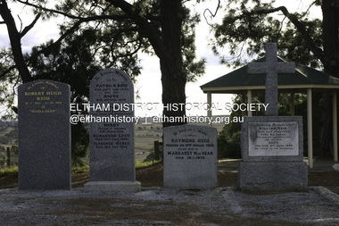
Photograph - Digital Photograph, Alan King, Reid family graves, Arthurs Creek Cemetery, 30 March 2008
... Scotland. Reid built a small cottage from local stone and hand-made bricks, with walls one yard (91 cm) thick, a flagstone floor and a shingle roof. Today two rooms and a store room survive as part of a larger house. Agnes died in 1847 aged 49, and was buried on a hill...Scotland. Reid built a small cottage from local stone and hand-made bricks, with walls one yard (91 cm) thick, a flagstone floor and a shingle roof. Today two rooms and a store room survive as part of a larger house. Agnes died in 1847 aged 49, and was buried on a hill ...The Arthurs Creek Cemetery was originally the private cemetery of pioneers Agnes and Patrick Reid. Published: Nillumbik Now and Then / Marguerite Marshall 2008; photographs Alan King with Marguerite Marshall.; p11 The Hazel Glen property, at Middle Hut Road, Arthurs Creek, which includes one of Victoria’s earliest pioneer buildings, was the forerunner to the Arthurs Creek and Doreen townships. At one time the Doreen Post Office and school were called Hazel Glen. The Hazel Glen State School No 945, before it was moved to its present site, stood on land to the south of Chapel Lane, which had been donated by Hazel Glen owner, William Reid. In May 1895 the post office was renamed Doreen to avoid confusion with the Reid’s address. The Arthurs Creek Cemetery was originally the private cemetery of Hazel Glen pioneers Agnes and Patrick Reid. The Reids with their eight children, arrived in Melbourne in April 1839. In 1844 Patrick Reid took over the licence to the Stewart Ponds run of 5120 acres (2072ha). Reid renamed it Hazel Glen, after Hazelden, the name of the Reid estate at Mearns in Renfrewshire, Scotland. Reid built a small cottage from local stone and hand-made bricks, with walls one yard (91 cm) thick, a flagstone floor and a shingle roof. Today two rooms and a store room survive as part of a larger house. Agnes died in 1847 aged 49, and was buried on a hill overlooking Hazel Glen, where it is said she had asked to be buried as it had been a favourite picnic spot.2 In 1858 Patrick died aged 74, and was buried near her. Their son William was to become Whittlesea Shire’s first president. From 1868 he was a Whittlesea Roads Board member, then a shire councillor until shortly before his death in 1923 aged 88. In 1865 the Reid’s burial area was no longer on their property, so it was declared a cemetery site. In 1867 it became the Linton Public Cemetery, being in the Linton Parish. However, to avoid confusion with Linton near Ballarat, the cemetery was renamed the Arthurs Creek Public Cemetery in 1926. Arthurs Creek was named after Henry Arthur, a pastoralist and public servant, who ran 1000 sheep lower down the Creek, from 1836 to 1841. It is believed he built his home at the end of today’s Challenger Street in Diamond Creek.This collection of almost 130 photos about places and people within the Shire of Nillumbik, an urban and rural municipality in Melbourne's north, contributes to an understanding of the history of the Shire. Published in 2008 immediately prior to the Black Saturday bushfires of February 7, 2009, it documents sites that were impacted, and in some cases destroyed by the fires. It includes photographs taken especially for the publication, creating a unique time capsule representing the Shire in the early 21st century. It remains the most recent comprehenesive publication devoted to the Shire's history connecting local residents to the past. agnes reid, arthurs creek cemetery, nillumbik now and then (marshall-king) collection, patrick reid, reid family -
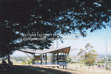 Eltham District Historical Society Inc
Photograph, Fay Bridge, Moor-rul Viewing Platform, Garden Hill, Kangaroo Ground, n.d
... Scottish influence of the first European settlers of the district from the 1840s onward. The park was opened in 1921 and the Tower of Remembrance was dedicated in 1926 recognising the local people who served in the First World War. Those who served in the Second World War were recognised by plaques dedicated in 1951 and more recently those who served in Korea, Borneo, Malaya and Vietnam by plaques unveiled in 2001. Harry Gilham, Advisory Committee Convenor - Eltham District Historical Society Newsletter N0 179 March 2008 Fay Bridge Collection Garden Hill ...OPENING OF THE VIEWING PLATFORM AT KANGAROO GROUND Nillumbik Council has advised that the viewing platform at Kangaroo Ground 27km NE of Melbourne is to be opened to the public on Wednesday, March 26th 2008 (Melway 271 , G10). The function of the platform is to provide shelter adjacent to the War Memorial Tower whilst allowing all people to enjoy the stunning panoramic views. From the platform you. can see the Dandenongs, the city of Melbourne, the You Yangs, Mount Macedon, the Kinglake Ranges and the Mt Baw-Baw Ranges where the Yarra River starts. This landscape covers all the ancestral lands of the Wurundjeri and some of the wider Kulin nation land. The platform has been given the name Moor-rut, a name which described the fertile soils of the Kangaroo Ground area in contrast to the poorer (Silurian) country of its surrounds, which the Wurundjeri knew as 'Nillumbik' or less rich country. The full 360 degree view can be seen from the adjacent Tower of Remembrance which has 53 stairs. The viewing platform however can be accessed by wheelchair. Inside the viewing platform there are eight double sided interpretive panels giving the history and information regarding this special area. The viewing platform's interpretive panels set out the Aboriginal and European history of the area and also the geology and the local flora and fauna, so that the casual visitor comes away understanding more about this significant part of Victoria. The concept of the viewing platform is part of the refurbishment project for the Kangaroo Ground War Memorial Park which has taken place since 1997 with the active approval and financial assistance of the Nillumbik Shire Council. This project has been guided by an Advisory Committee with volunteer community representatives from the local Historical Societies, the Country Fire Authority, the Returned Services League and the Wurundjeri people. Other allied groups such as the Nillumbik Reconciliation Group have been called upon for their expertise. The initial idea for the viewing platform came from Dean Stewart when he was the caretaker while living at the park. He discussed this idea with local author Mick Woiwod and Harry Gilham of Eltham District Historical Society when they were planning the refurbishment of the War Memorial Park in 1996. When the committee was formalised by the Nillumbik Council in 1997, Nicholas Pelling, representing the CFA and RSL, joined the group. Dennis Ward, local architect, then volunteered to develop the concept plan for the refurbishment of the park and later drew up the plans for the viewing platform. The Kangaroo Ground War Memorial Park and its Tower of Remembrance is located on one of the highest locations in the Yarra Valley. The Tower of Remembrance is a unique war memorial constructed from local stone standing 14 metres high. It was built in the style of a Scottish watchtower reflecting the strong Scottish influence of the first European settlers of the district from the 1840s onward. The park was opened in 1921 and the Tower of Remembrance was dedicated in 1926 recognising the local people who served in the First World War. Those who served in the Second World War were recognised by plaques dedicated in 1951 and more recently those who served in Korea, Borneo, Malaya and Vietnam by plaques unveiled in 2001. Harry Gilham, Advisory Committee Convenor - Eltham District Historical Society Newsletter N0 179 March 2008fay bridge collection, garden hill, kangaroo ground, memorial park, moor-rul viewing platform -
 Eltham District Historical Society Inc
Photograph, Donaldson's Oak, Donaldsons Road, Kangaroo Ground, c.1967
... Used for the Society's Banner project Joy Ness "View Hill" Kangaroo Ground June 11th 1986 In 1878 while on a trip to Scotland and England, John Donaldson visited Windsor Castle Park, where he collected some acorns which he brought back to Australia, to his property, "Kangaroo Hall" at Kangaroo Ground. ...Used for the Society's Banner project Joy Ness "View Hill" Kangaroo Ground June 11th 1986 In 1878 while on a trip to Scotland and England, John Donaldson visited Windsor Castle Park, where he collected some acorns which he brought back to Australia, to his property, "Kangaroo Hall" at Kangaroo Ground. ...Quercus Robur (English Oak) - Was planted by John Donaldson from seed collected from Windsor Great Park in 1878. Used for the Society's Banner project Joy Ness "View Hill" Kangaroo Ground June 11th 1986 In 1878 while on a trip to Scotland and England, John Donaldson visited Windsor Castle Park, where he collected some acorns which he brought back to Australia, to his property, "Kangaroo Hall" at Kangaroo Ground. He and his son John Anstruther Davidson Donaldson, who was then 10 years old, planted one near the present Donaldsons Lane, in 1878. This is now a very fine tree, 108 years old. This information comes from Miss Victoria Donaldson, daughter of John Anstruther Davidson Donaldson. Miss Donaldson suggests that "Wippell's Oak" at Kangaroo Ground may also have been grown from one of the same Windsor Park acorns.Colour Polaroid photographtrees, donaldsons oak, donaldson, donaldson road, kangaroo ground -
Glen Eira Historical Society
Newsletter - CAULFIELD DIPLOMAT
... Scotland to Melbourne in 1839-1840 on which many passengers died. Also included is a report on the inaugural meeting of the Caulfield Historical Society (13/09/1972), addressed by Dr. Weston Bate and a letter to the editor about old Caulfield by ‘Clip-Clop Cover’. One copy states (handwritten) that it was ‘donated by Rita Yorston’. Caulfield Caulfield Historical Society Bate Dr. Weston Rosstown tramway Glen Eira barque Horse tramways Cox’s Hill ...Contains 2 items: 1/Caulfield Diplomat No.1 (September 1972) (five copies). A local eight page magazine described as ‘local, monthly and independent’. It does not include any information about its editor or publication. Page one, ‘Chaff Bag’, by ‘Little Jack’ is about old Caulfield. There are numerous columns and many local advertisements including one for the inaugural meeting of the Caulfield Historical Society on 13/09/1972. 2/Caulfield Diplomat No.2 (October 1972) (three copies). Includes comments by ‘Little Jack’ about old Caulfield and an account of the voyage of the Glen Eira barque from Scotland to Melbourne in 1839-1840 on which many passengers died. Also included is a report on the inaugural meeting of the Caulfield Historical Society (13/09/1972), addressed by Dr. Weston Bate and a letter to the editor about old Caulfield by ‘Clip-Clop Cover’. One copy states (handwritten) that it was ‘donated by Rita Yorston’.caulfield, caulfield historical society, bate dr. weston, rosstown tramway, glen eira barque, horse tramways, cox’s hill, citizenship ceremonies, pentridge prison, bus services, spencer horrie, advertisements, caulfield cup, horse racing, horn k.a.r., foley dr. aileen, sinclair a.j.g, simms r.k., hart trevor, bell mrs agnes paton, authors, traffic signals, newsletters -
 Eltham District Historical Society Inc
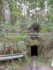
Photograph - Digital Photograph, Marguerite Marshall, One Tree Hill Mine, Smiths Gully, 8 June 2006
... Hill in 1998. As late as the 1920s gold was picked up by chance! When crossing a gully on his way to vote at the St Andrews Primary School, Bill Joyce picked up some quartz containing gold. This site was to become the Black Cameron Mine. The Caledonia Diggings, named after Scotland’s...Hill in 1998. As late as the 1920s gold was picked up by chance! When crossing a gully on his way to vote at the St Andrews Primary School, Bill Joyce picked up some quartz containing gold. This site was to become the Black Cameron Mine. The Caledonia Diggings, named after Scotland’s ...Gold was discovered on One Tree Hill in 1854. The site has been worked intermittently until fairly recent times. Published: Nillumbik Now and Then / Marguerite Marshall 2008; photographs Alan King with Marguerite Marshall.; p53 Though still a working mine, One Tree Hill Mine at Smiths Gully, now stands in a tranquil reserve surrounded by bush and native animals - in contrast to its heyday. In the mid 19th century, when the mine was part of the Caledonia Goldfields, hundreds of men in search of their fortune worked the alluvial gold in the Yarra River, its tributaries and the reefs that made up the goldfields. Miner Stan Bone, assisted by Wilfred Haywood, is the last of the independent gold miners in the area and still uses the quartz crushing battery as miners did when gold was first discovered in the area in 1851.1 Stan, who is the last of six generations of miners in his family, was aged 17 when he began mining on his father Alex’ mine, The Golden Crown in Yarrambat. These days, after blasting the gold-bearing rock in Mystery Reef, one of the four reefs at One Tree Hill, Stan transports it around five kilometres by tip truck to the Black Cameron Mine for crushing. There he uses water from the waterlogged mine, (which still contains gold), as the Happy Valley Creek at One Tree Hill is usually dry.2 The One Tree Hill Mine has been worked for close to a century since it opened around the late 1850s.3 The Swedish Reef was its most productive reef and one of the largest in the area. Around 1859, extractions included 204 ounces (5.8kg) of gold, won from 57 pounds (26kg) of stone.4 Then during World War Two, Stan’s uncle, Bill Wallace, and Alex Bone, closed the mine. In 1973, Stan, with his Uncle Bill, reopened the Black Cameron Mine and worked there until 1988. Stan resumed mining One Tree Hill in 1998. As late as the 1920s gold was picked up by chance! When crossing a gully on his way to vote at the St Andrews Primary School, Bill Joyce picked up some quartz containing gold. This site was to become the Black Cameron Mine. The Caledonia Diggings, named after Scotland’s ancient name by local Scots, began around Market Square (now Smiths Gully) and included Queenstown (St Andrews), Kingstown (Panton Hill) and Diamond Creek. There were also poorer bearing fields in Kangaroo Ground and Swipers Gully (now Research). * None of these compared in riches to the Ballarat and Bendigo fields5, but the Caledonia Diggings continued intermittently for close to 100 years. Gold was discovered in Victoria following a bid to stem the disappearance of much needed workmen to the New South Wales diggings. Several businessmen offered a reward of £200, for the discovery of gold within 200 miles (322 km) of Melbourne. Late in June 1851, gold was first discovered at Andersons Creek, Warrandyte. Then in 1854, George Boston and two other men discovered gold at Smiths Gully. Gold transformed the quiet districts, with a constant flow of families and vehicles on the dirt tracks en route to the Caledonia Diggings. Three thousand people worked the gullies in Market Square, including about 1000 Chinese miners. The square established its own police, mining warden, gold battery, school, shops and cemetery and grog flowed. Market Square flourished until the middle 1860s. Bullocks transported quartz from the Caledonia Goldfields to the crushing machinery at the Queenstown/St Andrews Battery, near Smiths Gully Cemetery. It was destroyed by bushfire in 1962. By the late 1850s, most early alluvial fields were in decline, but minor rushes continued until around 1900 and some until the early 1940s. Some miners did well, although most earned little from their hard labour in the harsh and primitive conditions.6 But according to historian, Mick Woiwod, the gold fields helped to democratise society, as individuals from all walks of life were forced to share experiences, and the ability to succeed, depended less on inherited wealth or social rank.This collection of almost 130 photos about places and people within the Shire of Nillumbik, an urban and rural municipality in Melbourne's north, contributes to an understanding of the history of the Shire. Published in 2008 immediately prior to the Black Saturday bushfires of February 7, 2009, it documents sites that were impacted, and in some cases destroyed by the fires. It includes photographs taken especially for the publication, creating a unique time capsule representing the Shire in the early 21st century. It remains the most recent comprehenesive publication devoted to the Shire's history connecting local residents to the past. nillumbik now and then (marshall-king) collection, gold mining, one tree hill mine, smiths gully -
 Eltham District Historical Society Inc
Photograph - Digital Photograph, Alan King, St Andrews Hotel, 2 February 2008
... Hill (formerly Kingstown), Research and Diamond Creek, from the mid-1850s to the 1860s. But by the early 20th century common use changed the name Queenstown to St Andrews, possibly after this hotel or after the church or the mining district.1 The Caledonia Diggings were probably named by Scottish settlers after the Roman name for Scotland, despite this land bearing little similarity to their homeland.2 Queenstown, which was proclaimed as a township in 1861, was the gold-mining centre on the Upper Diamond and in the 1850s had up to 600 European inhabitants and a small camp of Chinese on the flats along the creek. ...Hill (formerly Kingstown), Research and Diamond Creek, from the mid-1850s to the 1860s. But by the early 20th century common use changed the name Queenstown to St Andrews, possibly after this hotel or after the church or the mining district.1 The Caledonia Diggings were probably named by Scottish settlers after the Roman name for Scotland, despite this land bearing little similarity to their homeland.2 Queenstown, which was proclaimed as a township in 1861, was the gold-mining centre on the Upper Diamond and in the 1850s had up to 600 European inhabitants and a small camp of Chinese on the flats along the creek. ...The c1860 St Andrews Hotel, with the c1930 additions, and the Canary Island Palm, and the surrounding site to the title boundaries are historically, socially and aesthetically significant to the Shire of Nillumbik. The St Andrews Hotel is historically significant because it may have given its name 'St Andrews' to the town (another suggestion is that the name came from St Andrews church) and for its connection to Ewen Hugh Cameron (1831-1915) the prosperous local farmer, member of the Eltham Roads Board/Shire Council and local MP. It is also significant as the oldest hotel building in the former Shire of Eltham, as one of the few surviving buildings connected with the Caledonian goldfields era and as one of a handful of early structures to have survived the 1960s bushfires; the additions and alterations to the hotel reflect its long life. The hotel is socially significant because it has served as an important meeting place for more than 160 years. The Canary Island Palm is historically significant as a rare example of exotic tree planting in this rural area. The tree is aesthetically and historically significant as a local landmark and for its contribution to the streetscape and landscape value. Covered under Heritage Overlay, Nillumbik Planning Scheme. Published: Nillumbik Now and Then / Marguerite Marshall 2008; photographs Alan King with Marguerite Marshall.; p71 Built around 1860, St Andrews Hotel has changed little since it first welcomed thirsty gold diggers from the Caledonia Goldfields. The timber building, with gabled roof, beamed ceilings and a massive fireplace, is Nillumbik Shire’s oldest hotel and has always been an important community centre, particularly in its early days. Fortunately, the hotel and the near-by Canary Island Palm Tree, which is quite rare in this area, survived the 1960s bushfires, along with a few other early buildings. St Andrews (formerly Queenstown) was founded on gold, as were Panton Hill (formerly Kingstown), Research and Diamond Creek, from the mid-1850s to the 1860s. But by the early 20th century common use changed the name Queenstown to St Andrews, possibly after this hotel or after the church or the mining district.1 The Caledonia Diggings were probably named by Scottish settlers after the Roman name for Scotland, despite this land bearing little similarity to their homeland.2 Queenstown, which was proclaimed as a township in 1861, was the gold-mining centre on the Upper Diamond and in the 1850s had up to 600 European inhabitants and a small camp of Chinese on the flats along the creek. Queenstown was the administrative centre of the Upper Diamond with three hotels, a brewery and a slaughterhouse.3 It is unclear which hotel was the district’s first, as distinct from the earliest unlicensed grog shops, some of which operated in tents. John Corke Knell was one of eight unlicensed storekeepers supplying drink to miners at Caledonia in 1857, named by Sgt. McNamara of the Caledonia Police Station.4 In February 1859, Knell apparently bought most of the present hotel’s site at the first township land sales. As he was a local storekeeper, he might have first established a store there.5 Knell and his wife Eliza were early licensees of the St Andrews Hotel. The hotel had eight bedrooms – including three for public use – and the dining-room seated 30 people. It is thought they named the hotel St Andrews after Eliza’s hometown of St Andrews in Scotland. St Andrews Hotel was an important local centre in several ways. In the same building the Knells also operated a post office and general store. In 1867 Mrs Knell was appointed Deputy Registrar of Births and Deaths for Queenstown. The hotel was also used to hold inquests into people’s deaths when the police residence became too small.6 The hotel also became a fashionable destination at Christmas for parties from Melbourne. In 1868, possibly following her husband’s death, Mrs Knell applied for a temporary licence, which was then transferred to Robert Smith after their marriage in 1869. But then, possibly after Robert’s death, Mrs Smith operated the hotel until 1892. This contradicts a report in The Evelyn Observer 1882 that JC Knells of the St Andrews Hotel was granted a publican’s licence in the Queenstown Police Court. At that time he was supposed to have been dead for around 14 years! Although Mrs Smith was a respected citizen, known for her geniality and as an ideal hostess, she had a minor brush with the law when she was fined ten shillings for not lighting a lamp outside her licensed premises.7 From 1892 several publicans owned the hotel including W Atkins, from 1895. In 1909 the licensee was apparently Mrs Smith’s son, Walter Knell, who held the licence until at least the 1920s. Not surprisingly, this old hotel has attracted romantic stories. Mrs Smith is said to be seen roaming the pub in her nightdress – even though she was buried in the Queenstown Cemetery in 1911.8 A musical The Hero of Queenstown, set in the hotel, was written and produced by local actor Reg Evans in the 1970s.This collection of almost 130 photos about places and people within the Shire of Nillumbik, an urban and rural municipality in Melbourne's north, contributes to an understanding of the history of the Shire. Published in 2008 immediately prior to the Black Saturday bushfires of February 7, 2009, it documents sites that were impacted, and in some cases destroyed by the fires. It includes photographs taken especially for the publication, creating a unique time capsule representing the Shire in the early 21st century. It remains the most recent comprehenesive publication devoted to the Shire's history connecting local residents to the past. nillumbik now and then (marshall-king) collection, st andrews hotel -
 Eltham District Historical Society Inc
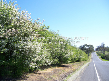
Photograph - Digital Photograph, Marguerite Marshall, Hawthorn hedges, Eltham-Yarra Glen Road, Kangaroo Ground, 3 October 2006
... Scotland. Some also used the hedges to net birds, presumably for the table. Interestingly the farmers in the bordering townships of Panton Hill and Christmas Hills, did not plant hawthorn hedges around their properties. ...Scotland. Some also used the hedges to net birds, presumably for the table. Interestingly the farmers in the bordering townships of Panton Hill and Christmas Hills, did not plant hawthorn hedges around their properties. ...Hawthorn hedges are important reminders of Kangaroo Ground's Scottish heritage. They are Registered on the Victorian Heritage Register. They are "historically significant because the planting of hawthorn hedges reflects the adoption of Eurorpean farming techniques by the Kangaroo Ground population in the period following settlement and because the grid pattern of paddocks that the Hawthorn hedges define is very different to today's farm landscapes." Covered under Heritage Overlay, Nillumbik Planning Scheme. Published: Nillumbik Now and Then / Marguerite Marshall 2008; photographs Alan King with Marguerite Marshall.; p21 Hawthorn hedges bordering Kangaroo Ground’s gently rolling farmlands are important reminders of its Scottish heritage and are rare so close to Melbourne.1 As early as the 1840s newly arrived farmers from Scotland planted hawthorn hedges around their properties, to protect crops from the numerous kangaroos and wallabies. Many of these hedges survive today. These farmers had the good fortune to settle some of the most fertile land available for cropping in the Colony of Victoria. At that time the black volcanic soil could sustain an amazing two crops a year. By the mid 1850s, 500 acres (202ha) of wheat were growing in Kangaroo Ground. But the crops were threatened by kangaroos, which were so plentiful, that Surveyor-General, Robert Hoddle, named the district Kangaroo Ground in 1838. As post-and-rail fences proved inadequate barriers for the bounding kangaroos, the Scots planted hawthorn hedgerows as they had done in Scotland. Some also used the hedges to net birds, presumably for the table. Interestingly the farmers in the bordering townships of Panton Hill and Christmas Hills, did not plant hawthorn hedges around their properties. Perhaps it was because by the time they settled in the 1860s and 1870s most of the wildlife had been gunned down by residents.2 The canny Scots planted the hedges on public land outside their own farms, as the hedgerows could spread to about five yards (five m) in width. With this impenetrable barrier Kangaroo Ground’s industrious farmers flourished to gain the economic power that saw the Shire of Eltham governed from Kangaroo Ground for 79 years (1858-1937). The Scots jealously guarded their land, so hard to get in Scotland. That is why they refused to release any of it ‘for local roads to follow easier grades as was the case in surrounding districts where roads generally followed ridgelines or streams’.3 Instead the roads were built in accordance with the magnetic bearings of their first survey in 1847 whether that suited the steep topography or not. This could force traffic to diverge when wet through Greensborough and Diamond Creek. Until 1921, the Eltham-Yarra Glen Road beside Wellers Restaurant, ‘dipped down into the upper reaches of Stony Creek’.4 Later some corners were compulsorily cut for the increasing motor traffic. As late as the 1960s, corners were cut to form sweeping curves above and alongside the Kangaroo Ground Cemetery and opposite the Emergency Operations Centre. In the latter case, the farmers – understanding their hedgerows as important heritage – insisted upon their reinstatement to conform to the altered road alignment. Kangaroo Ground’s ancient manna gums also point to the district’s history and to that of the hedgerows. The Aboriginal people had transformed the original forests into grasslands with the fires they lit to attract kangaroos, (which the Scots were to exclude by planting hedgerows). But the Wurundjeri hunters left the gums (Eucalyptus vimminalis cygnetensis), on the grasslands as ‘stalking trees’ to hunt kangaroos. The hawthorn hedges in Kangaroo Ground were neglected for around 60 years from about the middle of the 20th century. Bushfires had created gaps and the hedgerows were not trimmed. Then in late 2005, local historian Mick Woiwod, formed a group to lobby the Nillumbik Shire to restore the hedges, which could last for many centuries. Some hedges in parts of Britain date back to AD 800.5 Although the original Scottish farmers have gone, the hedges are a reminder of when they flourished in the district, which has changed little in 150 years.This collection of almost 130 photos about places and people within the Shire of Nillumbik, an urban and rural municipality in Melbourne's north, contributes to an understanding of the history of the Shire. Published in 2008 immediately prior to the Black Saturday bushfires of February 7, 2009, it documents sites that were impacted, and in some cases destroyed by the fires. It includes photographs taken especially for the publication, creating a unique time capsule representing the Shire in the early 21st century. It remains the most recent comprehenesive publication devoted to the Shire's history connecting local residents to the past. nillumbik now and then (marshall-king) collection, eltham-yarra glen road, hawthorn hedgerow, kangaroo ground -
 Eltham District Historical Society Inc
Photograph - Digital Photograph, Alan King, Pigeon Bank, Kangaroo Ground-Warrandyte Road, Kangaroo Ground, 6 February 2008
... On 4.8 hectares of farmland, Pigeon Bank is surrounded by rolling hills, farmland and bush, the peace of which is punctuated by an occasional birdcall. Pigeon Bank’s first owner was Francis Rogerson, from Dumfriesshire, Scotland, who bought 80 acres (32.4ha) of land in 1848 on which he built a two-roomed bark hut. ...On 4.8 hectares of farmland, Pigeon Bank is surrounded by rolling hills, farmland and bush, the peace of which is punctuated by an occasional birdcall. Pigeon Bank’s first owner was Francis Rogerson, from Dumfriesshire, Scotland, who bought 80 acres (32.4ha) of land in 1848 on which he built a two-roomed bark hut. ...In 1848, Francis Rogerson form Dumfriesshire, Scotland purchased 80 acres of land at Kangaroo Ground on which he built a two-roomed bark hut. He named the property afterr the many Bronzewings and Wonga Pigeons in the area. Ewen Hugh Cameron moved to Pigeon Bank the same year he was elected to Parliament as the Member for Evelyn. At the time he moved in, Pigeon Bank had six rooms and the present water well. He made further extensive additions and lived there until his death in 1915. Covered under Heritage Overlay, Nillumbik Planning Scheme. Published: Nillumbik Now and Then / Marguerite Marshall 2008; photographs Alan King with Marguerite Marshall.; p27 Pigeon Bank, on the Kangaroo Ground – Warrandyte Road, Kangaroo Ground, is one of the Shire’s oldest farm dwellings, and has been home to some of the district’s earliest and most distinguished families. Although close to the road, the white weatherboard Victorian farmhouse is ensured privacy by the trees and hedges around it. On 4.8 hectares of farmland, Pigeon Bank is surrounded by rolling hills, farmland and bush, the peace of which is punctuated by an occasional birdcall. Pigeon Bank’s first owner was Francis Rogerson, from Dumfriesshire, Scotland, who bought 80 acres (32.4ha) of land in 1848 on which he built a two-roomed bark hut. Today this is the centre piece of the 14-room home.1 Rogerson lined the rooms with tongue-and-groove boards and roofed them with wooden shingles and sapling frames, which remain under the present green corrugated iron roof. He named Pigeon Bank after the many forest bronzewing and Wonga Pigeons in the area at the time, and the name Bank was commonly used in Scotland. Rogerson was united with one of the oldest families in the area when his sister Janet married John Bell, son of William, the original Bell settler. When Ewen Cameron moved to Pigeon Bank in 1874 it had six rooms and the present water well. He made extensive additions to the house and farm buildings and lived at Pigeon Bank until his death in 1915. Cameron, who had arrived in Melbourne from Scotland in 1853, contributed an enormous amount to the community. He worked as a builder, as a miner at Andersons Creek, a storekeeper at Queenstown2 and as the first postmaster at Warrandyte. In 1867 he married Agnes Bell, daughter of local farmer, John Bell. Cameron was a member of the Eltham Road Board (which preceded the Shire Council) and for more than 50 years, from 1863, he was an Eltham Shire Councillor, being President three times. Cameron was the Member for Evelyn for 40 years from 1874. In the 1880s he became the Government Whip, in 1902 the Minister for Mines and Water Supply, and in 1904, the Minister for Health, Cameron was also an outstanding farmer, whose farm won the Agricultural Department prize for the finest in the district, three consecutive times. Not surprisingly Pigeon Bank became the centre of district life. Every New Year’s Eve, Cameron hired a highland piper, who marched from the Kangaroo Ground school house to Pigeon Bank playing his pipes.3 Distinguished visitors included opera singer, Dame Nellie Melba, Victorian Premier, Thomas Bent, Governor, Lord Hopetoun and artist, Longstaff. Following Cameron’s death, the property changed hands several times, then returned to the family in 1919 when bought by Gordon Cameron. As the car took over from the horse, Pigeon Bank entered difficult times because the farm had produced chaff and oats and bred Clydesdales and harness ponies. In 1926 Mr Matthews bought the property and made many alterations including pulling down the kitchen, which had been separate from the main house. The property again changed hands several times. One owner was Senator James F Guthrie, who added a sunroom. In 1968 the house again returned to the Cameron family, when Vera Jackson, a grand-daughter of Ewen Cameron, and her husband, bought the property. The Bishop family, who were sixth and seventh generation Bells and also descended from the Camerons, restored the house in the 1980s. Today tongue-and-groove boards still line part of the hall (which retains two fine arches), the breakfast room, and Ewen Cameron’s former room. Five original fireplaces in the bed and living rooms are still in working order. The wide veranda with a curved iron roof and ornate iron lace work bounds three sides of the house, and nearby a windmill stands beside the water well. Sue and Ron James, who bought the property in 2001, made extensive improvements to the homestead and meticulously restored the grounds to their original state.This collection of almost 130 photos about places and people within the Shire of Nillumbik, an urban and rural municipality in Melbourne's north, contributes to an understanding of the history of the Shire. Published in 2008 immediately prior to the Black Saturday bushfires of February 7, 2009, it documents sites that were impacted, and in some cases destroyed by the fires. It includes photographs taken especially for the publication, creating a unique time capsule representing the Shire in the early 21st century. It remains the most recent comprehenesive publication devoted to the Shire's history connecting local residents to the past. nillumbik now and then (marshall-king) collection, ewen hugh cameron, francis rogerson, kangaroo ground, kangaroo ground-warrandyte road, pigeon bank -
 Eltham District Historical Society Inc
Photograph - Digital Photograph, Alan King, Garden Hill, Eltham-Yarra Glen Road, Kangaroo Ground, 3 February 2008
... Built by Scottish farmer Andrew Harkness who acquired the property in 1849 at the top of the hill with magnificent panoramic views as far as Kinglake, the same year he married Sarah Oswin. ...Built by Scottish farmer Andrew Harkness who acquired the property in 1849 at the top of the hill with magnificent panoramic views as far as Kinglake, the same year he married Sarah Oswin. ...The original house was built around 1850 was one of Kangaroo Ground's earliest homes, part of which remains today. Built by Scottish farmer Andrew Harkness who acquired the property in 1849 at the top of the hill with magnificent panoramic views as far as Kinglake, the same year he married Sarah Oswin. The property was known as Garden Hill from at least 1865. Andrew and Sarah had four sons and five daughters. Harkness was a founder of the Kangaroo Ground School and one of the first to suggest establishing the Eltham District Road Board (1858-71) of which he was a member, the pre-cursor to the Shire of Eltham (1871-1994). He was also a Trustee of the Kangaroo Ground Cemetery. His daughter Fanny married farmer Alexander White who purchased the property in 1893. Alexander White died in 1906 and ownership transferred to Fanny White. Son, Robert White was a Councillor of the Shire of Eltham at the time the Shire acquired two acres of land on the adjacent property from the Mess brothers for the creation of the Shire of Eltham Memorial Park (1921) in which the Shire of Eltham War Memoirial tower was erected (1926). Fanny White donated a small section of land from the Garden Hill property to facilitate entry access to the park. The White family sold the property to Sir Herbert Gepp in 1925. Covered under Heritage Overlay, Nillumbik Planning Scheme. Published: Nillumbik Now and Then / Marguerite Marshall 2008; photographs Alan King with Marguerite Marshall.; p29This collection of almost 130 photos about places and people within the Shire of Nillumbik, an urban and rural municipality in Melbourne's north, contributes to an understanding of the history of the Shire. Published in 2008 immediately prior to the Black Saturday bushfires of February 7, 2009, it documents sites that were impacted, and in some cases destroyed by the fires. It includes photographs taken especially for the publication, creating a unique time capsule representing the Shire in the early 21st century. It remains the most recent comprehenesive publication devoted to the Shire's history connecting local residents to the past. nillumbik now and then (marshall-king) collection, kangaroo ground -
 Eltham District Historical Society Inc
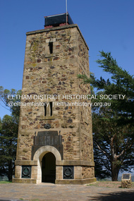
Photograph - Digital Photograph, Alan King, Shire of Eltham War Memorial, Kangaroo Ground, 28 January 2008
... Scottish border from the mid 14th century to around 1600 and is constructed from locally quarried stone. This uncommon and picturesque war memorial, which affords an excellent view of the surrounding district was unveiled by His Excellency the Governor-General (Lord Stonehaven) on November 11, 1926. In July 1922 a deputation of returned soldiers from Panton Hill...Scottish border from the mid 14th century to around 1600 and is constructed from locally quarried stone. This uncommon and picturesque war memorial, which affords an excellent view of the surrounding district was unveiled by His Excellency the Governor-General (Lord Stonehaven) on November 11, 1926. In July 1922 a deputation of returned soldiers from Panton Hill ...The Eltham Shire War Memorial, a tower of remembrance, was built with public donations to commemorate the memory of the fallen soldiers from the shire who enlisted in the 1914-1918 war. The tower is reminiscent of the peel-towers or watchtowers that lined the English-Scottish border from the mid 14th century to around 1600 and is constructed from locally quarried stone. This uncommon and picturesque war memorial, which affords an excellent view of the surrounding district was unveiled by His Excellency the Governor-General (Lord Stonehaven) on November 11, 1926. In July 1922 a deputation of returned soldiers from Panton Hill, presumably the Panton Hill branch of the Returned Sailors and Soldiers Imperial League of Australia (RSSILA), proposed to Eltham Shire Council that the monument should be a cairn of local stone “sufficiently high to form a prominent and conspicuous landmark, and crowned with some suitable device”. Eltham Shire Councillor and President of the Panton Hill branch of the RSSILA, Basil Hall, was credited with being the first to suggest a tower, and with organising a Memorial Park committee to raise funds for the monument in the Memorial Park. A meeting for those interested in the establishing a War Memorial monument in the park was held in January 1924 and the Eltham Shire War Memorial League was formed for this purpose. It appears that the broad and rounded cairn that had been recently built was considered by the League a temporary affair, and not the substantial cairn-as-monument, sufficiently high to form the conspicuous landmark, which had been envisaged by the Panton Hill RSSILA. A design competition was held for the monument. The chairman of the League, Councillor Basil Hall, suggested that the site of the memorial in Kangaroo Ground would lend itself to something rugged, instead of polished stone. By April 1924 thirty designs for a memorial had been received from which three designs were selected and of those, the design by the shire engineer Mr McCormack, for a 70ft tower suitable for construction in rough stone, was chosen. Artist Harold Herbert suggested that a peel tower-like design reminiscent of those along the English-Scottish border would be fitting for the site. Herbert drew up a rough sketch that was approved of, and later, Melbourne architect Percy Meldrum volunteered to draw up the design from sketch to architectural drawings. By January 1925 the Soldiers’ Memorial League had adopted Meldrum’s design for a 50ft high tower. Meldrum had also offered his design and supervision of construction free of charge. The Shire provided the stone to the builders, which was a gift quarried from land owned at Kangaroo Ground by Dr Ethel and Professor William Osborne The Shire of Eltham War Memorial, a tower of remembrance, and honour board were unveiled on November 11, 1926, by the Governor General Lord Stonehaven. At this stage a temporary honour roll was painted on the panels on either side of the tower entrance. In September 1930 bronze plates were added above the portal with the names of men who fell in the 1914-18 war. On November 16, 1951, the Governor of Victoria, Sir Dallas Brooks re-dedicated the war memorial tower and unveiled the names of men who gave their lives in the 1939-45 war. Two additional bronze plaques which recognise service in the armed conflicts of Korea, Borneo, Malaya, and Vietnam were unveiled November 11, 2001, by the Governor of Victoria, John Landy, A.C., M.B.E. The tower was first used for fire spotting activities following the Black Friday bushfire in January 1939 in response to a request from Mr R.D. Ness, secretary of the Kangaroo Ground bush fire brigade, who asked Council that the tower be used as an observation tower for detecting bush fires, and asked Council to arrange a telephone to be installed. It was suggested that if the Shire were to appoint a caretaker for the Memorial Park, his duties could also include raising the alarm in the event of a fire. Later in 1939 Council applied for a radio transmitter, which the Forestry Commission planned to install at vantage places throughout the state. The first dedicated fire spotter appointed from December1948, was Mr Smith of Warrandyte. A prefabricated glazed cabin was installed in 1974, which involved the removal of the original stone structure around the rooftop exit door. A new fire spotting cabin, which included the latest technology, was installed soon after the 2009 Black Saturday fires and is manned by CFA personnel on high fire danger days. Covered under Heritage Overlay, Nillumbik Planning Scheme. Published: Nillumbik Now and Then / Marguerite Marshall 2008; photographs Alan King with Marguerite Marshall.; p123This collection of almost 130 photos about places and people within the Shire of Nillumbik, an urban and rural municipality in Melbourne's north, contributes to an understanding of the history of the Shire. Published in 2008 immediately prior to the Black Saturday bushfires of February 7, 2009, it documents sites that were impacted, and in some cases destroyed by the fires. It includes photographs taken especially for the publication, creating a unique time capsule representing the Shire in the early 21st century. It remains the most recent comprehenesive publication devoted to the Shire's history connecting local residents to the past. While published in the book in black and white, this collection features the original colour digital photographs. nillumbik now and then (marshall-king) collection, garden hill, kangaroo ground, memorial park, shire of eltham war memorial -
 Eltham District Historical Society Inc
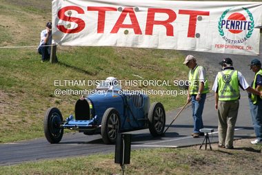
Photograph - Digital Photograph, Alan King, Rob Roy Hill Climb, 24 November 2007
... Hills are home to one of the world’s oldest purpose-built motor sport venues - the Rob Roy Hillclimb. When sealed in 1939, the hillclimb at Clintons Road was one of only three specially designed bitumen surface hillclimbs in the world, the others being Shelsley Walsh and Prescott Hillclimbs in the UK.1 The Rob Roy Hillclimb originated in 1935 on the property of former Heidelberg mayor, William Clinton, where he reared the Rob Roy breed of miniature ponies. Rob Roy was the Scottish...Hills are home to one of the world’s oldest purpose-built motor sport venues - the Rob Roy Hillclimb. When sealed in 1939, the hillclimb at Clintons Road was one of only three specially designed bitumen surface hillclimbs in the world, the others being Shelsley Walsh and Prescott Hillclimbs in the UK.1 The Rob Roy Hillclimb originated in 1935 on the property of former Heidelberg mayor, William Clinton, where he reared the Rob Roy breed of miniature ponies. Rob Roy was the Scottish ...The Rob Roy Hill Climb originated in 1935 on the property of former Heidelberg Mayor, William Clinton, where he reared the Rob Roy breed of miniature ponies. He established Pleasure Grounds on part of the property attracting groups of Sunday visitors from Melbourne's inner suburbs. Visitors enjoyed a picnic area, pony rides, a dance hall and a tap room. Young men would ride their BSA or Harley Davidson motorcycles to the property which led to regular club-organised hillclimb meetings between 1930 and 1936. In 1935 Clinton offered the use of his property to the Light Car Club of Australia for their hillclimbs. The track was sealed that same year and the hillclimb at Clintons Road was one of only three specially designed bitumen surface hillclimbs in the world, the others being Shelsey Walsh and Prescott Hillclimbs in the UK. The first Light Car Club of Australia hillclimb was held at Rob Roy in February 1937. Covered under Heritage Overlay, Nillumbik Planning Scheme. Published: Nillumbik Now and Then / Marguerite Marshall 2008; photographs Alan King with Marguerite Marshall.; p133 About six times a year the unlikely sound of car engines emerges from deep in the heart of Christmas Hills.* Usually a quiet retreat, the Hills are home to one of the world’s oldest purpose-built motor sport venues - the Rob Roy Hillclimb. When sealed in 1939, the hillclimb at Clintons Road was one of only three specially designed bitumen surface hillclimbs in the world, the others being Shelsley Walsh and Prescott Hillclimbs in the UK.1 The Rob Roy Hillclimb originated in 1935 on the property of former Heidelberg mayor, William Clinton, where he reared the Rob Roy breed of miniature ponies. Rob Roy was the Scottish folk hero and outlaw. On part of his property Clinton established Pleasure Grounds, attracting Sunday parties from Melbourne’s inner suburbs. Visitors enjoyed a picnic area, pony rides, a dance hall and a tap room.2 Young men riding on their BSA or Harley Davidson bikes led to club-organised regular hillclimb meetings, between 1930 and 1936. In 1935 Clinton offered his property to the Light Car Club of Australia for their hillclimbs. In February 1937, the first Light Car Club of Australia hillclimb meeting was held at Rob Roy. Jack Day achieved the fastest time that day for the 760 yard (695m) track at 36 seconds in a Ford V8 engined Bugatti Special. At first the climb was just a dusty gravel track, but in 1939 it was up-graded and bituminised. Today the 695 metre track begins on a slight incline, proceeds through a sharp right turn, which formerly passed a rusty iron shed, now remembered by the name Tin Shed Corner. The track continues down a slight incline to a level stretch along the top of an embankment holding back a half-acre (0.2ha) dam, then up to a one-in-three gradient. The track then winds uphill through several left turns to the finish line. In 1939 Frank Kleinig reduced the record to 29.72 seconds in an MG Hudson. Throughout World War Two the Rob Roy Hillclimbs were suspended, but were resumed in 1947. The hillclimbs consistently attracted crowds averaging 500 to 600 people, peaking at 2000, until the hillclimb was destroyed by the 1962 bushfires. The meetings included nine Australian Hillclimb Championships, with the first in 1938 won by Peter Whitehead in his ERA. Eight of the Outright and Class record holders were Australian Grand Prix winners including Jack Brabham, who became a triple F1 World Champion. The Light Car Club of Australia held 61 meetings at Rob Roy. Events usually included Touring, Gran Turismo, Production, Sports, Racing and Vintage cars and in the latter years Go-carts. These meets suddenly stopped after the 1962 bushfire destroyed the access bridge on the property leading to the track area, although fortunately Clinton saved his home. The club then established the Lakeland Hillclimb venue close to Lilydale.3 From 1979 to 1987 the MG Car Club ran hill climbs at the Templestowe Hillclimb until the land was to be sub-divided. In 1991 the MGCC approached the Shire of Nillumbik about using the derelict Rob Roy venue. In 1992, after much lobbying, the club signed a ten-year lease from Melbourne Water, which has been renewed. The original track was faithfully reconstructed. Access roads were improved and guard rails were installed on the causeway. Permanent structures were rebuilt and tonnes of rubbish removed. This was made possible by an immense amount of voluntary work by MGCC members and financial support from the newly formed Friends of Rob Roy. In February 1993 the first Return to Rob Roy Historic Meeting was run with a huge spectator attendance of around 1000 enthusiasts. In September 2007, the Nillumbik Shire Council gave the hillclimb heritage protection. This acknowledged the property’s significant contribution to early Australian motor sport with its social connection to William Clinton and the local community.4 *Christmas Hills was named after emancipated convict and shepherd David Christmas, lost in these hills.This collection of almost 130 photos about places and people within the Shire of Nillumbik, an urban and rural municipality in Melbourne's north, contributes to an understanding of the history of the Shire. Published in 2008 immediately prior to the Black Saturday bushfires of February 7, 2009, it documents sites that were impacted, and in some cases destroyed by the fires. It includes photographs taken especially for the publication, creating a unique time capsule representing the Shire in the early 21st century. It remains the most recent comprehenesive publication devoted to the Shire's history connecting local residents to the past. nillumbik now and then (marshall-king) collection, rob roy hill climb, clintons road, light car club of australia, william clinton -
 Bendigo Historical Society Inc.
Document - MCCOLL, RANKIN AND STANISTREET COLLECTION: MONUMENTAL HILL MINE NL STATEMENT OF ACCOUNTS, June 1846 to June 1912
... Hard cover folder containing paper bank statement of accounts of Monument Hill Consolidated NL dividend accounts. The English Scottish & Australian Bank Limited....Hard cover folder containing paper bank statement of accounts of Monument Hill Consolidated NL dividend accounts. The English Scottish & Australian Bank Limited. ...Document. McColl Rankin & Stanistreet: Monument Hill Consolidated Mine NL statements. Hard cover folder containing paper bank statement of accounts of Monument Hill Consolidated NL dividend accounts. The English Scottish & Australian Bank Limited.cottage, miners, mccoll rankin & stanistreet monument hill consolidated mine nl the english scottish & australian bank ltd. -
 Bendigo Historical Society Inc.
Document - MCCOLL, RANKIN AND STANISTREET COLLECTION: NEW MONUMENT GMC N/L - BANK ACCOUNT BOOKS, 1939 - 1944
... History House 11 Mackenzie Street Bendigo goldfields ORGANIZATION Business new monument gmc n/l McColl Rankin & Stanistreet New Monument GMC N/L Monument Hill Consolidated The English Scottish & Australian Bank Limited gold mining pass books McColl, Rankin & Stanistreet Documents. 4 blue/grey cloth covered account passbooks (stapled) in account with The English Scottish & Australian Bank Limited. ...Documents. 4 blue/grey cloth covered account passbooks (stapled) in account with The English Scottish & Australian Bank Limited.McColl, Rankin & Stanistreetorganization, business, new monument gmc n/l, mccoll, rankin & stanistreet, new monument gmc n/l, monument hill consolidated, the english scottish & australian bank limited, gold mining, pass books -
The Beechworth Burke Museum
Audio - Oral History, Jennifer Williams, Mrs Vanessa McDonald, 9 November 2000
... McDonald spent her childhood in the isolated hamlet of Stanley, in the area known as 'Little Scotland', where she recalls helping her mother to raise younger siblings, picking apples and walnuts on the family farm, and roaming the hills for wildflowers. ...McDonald spent her childhood in the isolated hamlet of Stanley, in the area known as 'Little Scotland', where she recalls helping her mother to raise younger siblings, picking apples and walnuts on the family farm, and roaming the hills for wildflowers. ...Mrs. Vanessa McDonald was born in Beechworth in 1917. Christened, Agnes Bertha Collins, Vanessa changed her name in 1960. Mrs. McDonald's family's connection with gold mining in the district reach back to the first of Beechworth's gold rushes, when her great grandfather, a Dutchman who adopted the name Charles Collins, arrived in 1851-1852. Mrs. McDonald spent her childhood in the isolated hamlet of Stanley, in the area known as 'Little Scotland', where she recalls helping her mother to raise younger siblings, picking apples and walnuts on the family farm, and roaming the hills for wildflowers. As a young woman Mrs. McDonald attended religious and social gatherings in the local community. In 1940 she went to Melbourne to work as a mothercraft nurse during the Second World War. She met her husband at a Beechworth football match and was married at the Stanley Methodist Church in 1941. The gold diggings known as the 'Nine Mile' became the hamlet of Stanley, after the British Prime Minister, Lord Stanley, in 1858. By the late 1850s, Stanley boasted schools, an athenaeum, a church, a weekly newspaper and several hotels and other civic infrastructure to cater for a growing population. The area attracted large numbers of Chinese miners, whose presence was frequently resisted. Like other early Victorian mining settlements, Stanley was a hotbed of political and racial tensions during the gold rush. One side of the Nine Mile Creek was known as 'Little Scotland’, the other, 'Little Ireland'. A number of Christian denominations built congregations and churches in Stanley, including the Church of England, Methodist Church, the Catholic Church, and Presbyterian Church. Stanley became part of the United Shire of Beechworth in 1871. By 1880 timber was being cut and two sawmills were established by 1887. River-dredged gold mining consumed vast amounts of timber from the forests in the area, and in 1931 the first of several softwood plantations began. This oral history recording was part of a project conducted by Jennifer Williams in the year 2000 to capture the everyday life and struggles in Beechworth during the twentieth century. This project involved recording seventy oral histories on cassette tapes of local Beechworth residents which were then published in a book titled: 'Listen to what they say: voices of twentieth century Beechworth'. These cassette tapes were digitised in July 2021 with funds made available by the Friends of the Burke.Following the decline in the mining and associated industries during the early-mid-twentieth century, the Beechworth district experienced a period of general economic decline. On the east side of the Dingle Range, Mrs. McDonald's father, William Henry Collins, felled timber and the family were pioneer apple orchardists. The establishment of apple orchards in Stanley reflects changes to how land was used and contributes to our understanding of the historical development of rural communities following the gold rush. Mrs. McDonald's recollections are significant for understanding family and social life in a small rural town in years leading up to the Great Depression and prior to the Second World War. This oral history recording may be compared with other oral histories and items in the Burke Museum's collection. This oral history account is socially and historically significant as it is a part of a broader collection of interviews conducted by Jennifer Williams which were published in the book 'Listen to what they say: voices of twentieth-century Beechworth.' While the township of Beechworth is known for its history as a gold rush town, these accounts provide a unique insight into the day-to-day life of the town's residents during the 20th century, many of which will have now been lost if they had not been preserved.This is a digital copy of a recording that was originally captured on a cassette tape. The cassette tape is black with a horizontal white strip and is currently stored in a clear flat plastic rectangular container. It holds up 40 minutes of recordings on each side.Mrs Vanessa McDonald /listen to what they say, beechworth, oral history, burke museum, emigration, gold rush immigration, victorian gold rush, mining families, apple orchard, forestry, forest plantation, little scotland, stanley, twentieth century history, regional australia, rural australia, farming, harvest festival, great depression, dingle range, the nine mile, australian wildflowers, high country wildflowers, mothercraft nurse, rural and regional women, social history, collins, mrs. vanessa mcdonald, building community life, shaping cultural and creative life, fruit growers, family history, changes to land use in regional victoria -
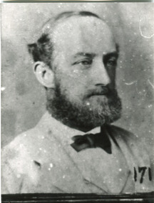 The Beechworth Burke Museum
Photograph - Photograph Reproduction, 1870
... The man depicted is Doctor Thomas Thomson Dick, who was the first Medical Superintendent at Mayday Hills Hospital. He was born in Scotland in 1840 and he died in East Malvern in 1919. ...The man depicted is Doctor Thomas Thomson Dick, who was the first Medical Superintendent at Mayday Hills Hospital. He was born in Scotland in 1840 and he died in East Malvern in 1919. ...The photograph is a copy of the original one, with the latter been captured in 1870. The man depicted is Doctor Thomas Thomson Dick, who was the first Medical Superintendent at Mayday Hills Hospital. He was born in Scotland in 1840 and he died in East Malvern in 1919. He obtained his degree of Doctor of Medicine from Melbourne University in 1864 and, later in his career, he became Inspector-General of the mentally ill. Dr Dick promoted the hospital`s self-sufficiency by engaging patients in various forms of work, such as clothing alterations and cultivation of the farm. He also introduced monthly balls, which could be attended by patients, staff and guests, and they were later replaced by concerts. The Mayday Hills Hospital was constructed between 1864 and 1867, with buildings created in a number of periods. It formally opened on 24 October 1867 and, along with the Ovens Hospital and the Benevolent Asylum, made Beechworth a prominent social welfare centre in Victoria. The need for an institution of this kind was arisen due to the increased number of people with mental disturbances (induced by the harsh living conditions on the goldfields) and the remoteness of the district from Melbourne. The site was chosen for its panoramic view of the countryside, the hilltop atmosphere and the native fauna, all contributing to the cure of patients.The Hospital was originally named the “Ovens Lunatic Asylum” but, during the centenary celebrations in 1967, the name was officially changed to “Mayday Hills Hospital”, showing the gradual shift in the perception and understanding of mental health conditions over the last decades. The Hospital lies on the traditional land of the Kulin Nation.This photograph is historically significant as it provides information about the staff served at the Mayday Hills Hospital when it first opened. It also contributes to the understanding of the district`s development and its importance to the course of Victoria`s history and adds valuable information about the changing approaches to the treatment of mental health conditions.Black and white rectangular photograph printed on paper.Obverse: (7)/ Reverse: 1997.2452/ Dr Dick/No(7) Pioneer Board/doctor thomas thomson dick, superintendent, mayday hills hospital, scotland, east malvern, doctor of medicine, melbourne university, inspector-general, clothing alterations, cultivation of the farm, self-sufficiency, balls, concerts, ovens hospital, benevolent asylum, beechworth, goldfields, kulin nation, panoramic view, mental health conditions -
 Halls Gap & Grampians Historical Society
Book - B/W
... Scotland. The story is of a boy who was parted from this mother during his early childhood, and was given to a shepherd who raised him. Some eighteen years later the mother by chance happens to meet here son, and not knowing his true identity, asks his name. He answers, "My name is Norval; and in the Grampian hills...Scotland. The story is of a boy who was parted from this mother during his early childhood, and was given to a shepherd who raised him. Some eighteen years later the mother by chance happens to meet here son, and not knowing his true identity, asks his name. He answers, "My name is Norval; and in the Grampian hills ...Norval Guest-House Aginda and Wettenhall The original Norval The story of Norval begins in 1917 when it was built as a private residence for Mr and Mrs William Thompson. Mrs Thompson was a pioneer of the tourist business, having come from Ballarat to Hall's Gap in 1909 to manage Bellfield Guest-house According to Ida Stanton, in her history of Hall's Gap entitled "Bridging the Gap", Mr Thompson and his wife acquired the six roomed shearers quarters at "Hankelow", on land leased by the Wettenhall family, on the south side of Bellfield. Mr Thompson, she says, completely dismantled the quarters, carefully marking each board, then hired George McKeon to cart the material up to where the original Norval house stood. With great care, the rooms were rebuilt into a home for William and his wife Mathilda. Catherine Good, the daughter of Viola (nee Wettenhall) and niece of Dr Roland, in here "Recollections" entitled "Look to the Mountains - Viola's View 1887-1979", mentions Hankelow. Speaking of her days at Glen Holford, the Wettenhall home at Pomonal, Viola says "Verona and Francie Dennis, my cousins, and I went for one very exciting trip. Father (i.e Dr Roland's father) had bought 300 acres in the Gap to take sheep from Carr's Plains in time of drought, and had a little cottage there with one of the Glen Holford men and his wife in charge. It was called Hankelow. So we three set off over the Range from Glen Holford on foot and leading a pack horse with our night attire and no doubt sponge bags. "We stayed the night at Hankelow with Jim and Minnie. Minnie had been a housemaid at Glen Holford. I was very fond of her. It makes one laugh to think of the excitement of "roughing it"! Minnie gave us a lovely dinner with meringues, and cream, I remember, then early morning tea. After breakfast we were driven in the buggy to the foot of the Goat Rock (since renamed Mt Rosea) and off we went - walking in our long skirts and ankle boots. There was no track of any kind, nor blazed trail - we just made for the top. It was rather frightening at times because we couldn't see where the top was an it always seemed to get further and further away. The last mile was so terribly steep, with a lot of lose shale where you went up twelve inches and slipped back six. Now you motor to about a couple of miles from the top and then have a graded path. Anyway, we got there and back safely and were rewarded with a magnificent view" By a strange coincidence, Hankelow, the source of Norval Guest-house in times past (if the name can be applied to the property as a whole, which seems likely) is in fact also the source of our Wettenhall Campsite! Hankelow was named after a property owned by the Wettenhall family in England. In 1917 William and Mathilda retired to their newly built home (Norval) "to escape from the tourist business" However, so many people made requests to stay with them that they found it necessary to add several more rooms and sleepouts to their home. In this way, early in 1921, the guest-house began to take shape. Mr Thompson, a former librarian of the Mechanics Institute in Ballarat, named the house "Norval". The name "Norval" comes from a quotation from the play 'Douglas" by John Home. Written in the mid-16th century the play is set in the Grampian Mountains of Scotland. The story is of a boy who was parted from this mother during his early childhood, and was given to a shepherd who raised him. Some eighteen years later the mother by chance happens to meet here son, and not knowing his true identity, asks his name. He answers, "My name is Norval; and in the Grampian hills my father feeds his flocks." Perhaps it was simply because "Norval" was associated with the "Grampians" that it was chosen by Mr Thompson. He may also have been conscious of feeding "flocks" of tourists in his expanding, guest-house. Norval Guest-house prospered. It was known for its fine cooking and friendly atmosphere - a tradition which has carried through to the modern Norval! It closed between 1940 and 1949 because of the second world war. In 1949 it was decided to almost completely rebuild the house. Most of the old building (Hankelow plus) was demolished and rebuilt to a much larger and more modern plan. And then, on May 1, 1965, it was purchased by the Committee of Management of the Methodist and Presbyterian Conference Centres. At this time the guest-house was owned and operated by Marjorie and Lachland McLennan, Mrs McLennan being the daughter of William and Mathilda Thompson, the pioneers of the establishment. The McLennans had operated the Guest-house since about 1930.Photocopy 2 pages of article from book titled 'In the Making' title of article Norval guest House the original Norvalaccommodation, guesthouses, norval -
 Mission to Seafarers Victoria
Photograph - Photograph, copy, The Age, St Nicholas' Mariners' Church, at Williamstown Mission to Seamen, with the lay reader in charge (Mr Stewart Murray) conducting a service, 14 June 1958
... The furniture and window were donated in 1979 to the Flagstaff Hill Maritime Village in Warrnanbool, and located in the chapel. randall stewart murray st nicholas the mariner chapel chapel lay reader williamstown victorian-seamens-mission 139 nelson place e,s and a bank english, scottish and australian bank stained-glass window pews lightkeepers' auxiliary warrnambool mrs musther brooks, robinson & co hymn board david conolly Hand written in black texta; ... ...The photograph wa published in the Age, 14th of June 1958. The picture shows the round stained glass dedicated on Sunday 14 December 1947 and the reredos with hangings donated by Maud Breaks in memory of her sister Louise Breaks and dedicated on 26 August 1954 by the Bishop of Geelong.This is a rare picture of the interior of the St Nicholas chapel which was erected behind the former E, S & A Bank building used by the Williamstown Seamen's Mission branch from 1944. Article in the Age reading: "Seamen's Window Dedicated - A window in St. Nicholas' Mariners' Church, at Williamstown, in memory of the merchant seamen who were killed on active service In the last war, was unveiled and dedicated yesterday.The ceremony was performed by the Bishop of Geelong (Rt. Rev. J. D. McKie). The window, erected by the Williamstown Lightkeepers' Auxiliary of the Victoria Missions to Seamen is placed behind the altar. It shows a quartermaster, with his hand on the wheel, and the figure of Christ pointing ahead. Bishop McKie paid a tribute to the spirit of the men who gave their lives at sea in the service of their country. He said the work of the auxiliary would still be of great value, although the war was over." The decision of the window was published in August 1947, Mrs Musther -who created the Lightkeepers' Auxiliary branch in Williamstown - ordered it from Brooks, Robinson & Co. (job books 1923-1966). The furniture and window were donated in 1979 to the Flagstaff Hill Maritime Village in Warrnanbool, and located in the chapel.Black and White Gloss print photograph - Image features a minister delivering a chapel serviceHand written in black texta; ... Mission to Seamen, Williamstown Chapel service... Circa 1957randall stewart murray, st nicholas the mariner chapel, chapel, lay reader, williamstown, victorian-seamens-mission, 139 nelson place, e,s and a bank, english, scottish and australian bank, stained-glass window, pews, lightkeepers' auxiliary, warrnambool, mrs musther, brooks, robinson & co, hymn board, david conolly -
 Eltham District Historical Society Inc
Photograph - Black and White Print, Moor-rul Viewing Platform, March 2007
... Scottish influence of the first European settlers of the district from the 1840s onward. The park was opened in 1921 and the Tower of Remembrance was dedicated in 1926 recognising the local people who served in the First World War. Those who served in the Second World War were recognised by plaques dedicated in 1951 and more recently those who served in Korea, Borneo, Malaya and Vietnam by plaques unveiled in 2001. Harry Gilham, Advisory Committee Convenor - Eltham District Historical Society Newsletter N0 179 March 2008 Moor-rul Viewing Platform Garden Hill ...Early stages - no display panels installed. OPENING OF THE VIEWING PLATFORM AT KANGAROO GROUND Nillumbik Council has advised that the viewing platform at Kangaroo Ground 27km NE of Melbourne is to be opened to the public on Wednesday, March 26th 2008 (Melway 271 , G10). The function of the platform is to provide shelter adjacent to the War Memorial Tower whilst allowing all people to enjoy the stunning panoramic views. From the platform you. can see the Dandenongs, the city of Melbourne, the You Yangs, Mount Macedon, the Kinglake Ranges and the Mt Baw-Baw Ranges where the Yarra River starts. This landscape covers all the ancestral lands of the Wurundjeri and some of the wider Kulin nation land. The platform has been given the name Moor-rut, a name which described the fertile soils of the Kangaroo Ground area in contrast to the poorer (Silurian) country of its surrounds, which the Wurundjeri knew as 'Nillumbik' or less rich country. The full 360 degree view can be seen from the adjacent Tower of Remembrance which has 53 stairs. The viewing platform however can be accessed by wheelchair. Inside the viewing platform there are eight double sided interpretive panels giving the history and information regarding this special area. The viewing platform's interpretive panels set out the Aboriginal and European history of the area and also the geology and the local flora and fauna, so that the casual visitor comes away understanding more about this significant part of Victoria. The concept of the viewing platform is part of the refurbishment project for the Kangaroo Ground War Memorial Park which has taken place since 1997 with the active approval and financial assistance of the Nillumbik Shire Council. This project has been guided by an Advisory Committee with volunteer community representatives from the local Historical Societies, the Country Fire Authority, the Returned Services League and the Wurundjeri people. Other allied groups such as the Nillumbik Reconciliation Group have been called upon for their expertise. The initial idea for the viewing platform came from Dean Stewart when he was the caretaker while living at the park. He discussed this idea with local author Mick Woiwod and Harry Gilham of Eltham District Historical Society when they were planning the refurbishment of the War Memorial Park in 1996. When the committee was formalised by the Nillumbik Council in 1997, Nicholas Pelling, representing the CFA and RSL, joined the group. Dennis Ward, local architect, then volunteered to develop the concept plan for the refurbishment of the park and later drew up the plans for the viewing platform. The Kangaroo Ground War Memorial Park and its Tower of Remembrance is located on one of the highest locations in the Yarra Valley. The Tower of Remembrance is a unique war memorial constructed from local stone standing 14 metres high. It was built in the style of a Scottish watchtower reflecting the strong Scottish influence of the first European settlers of the district from the 1840s onward. The park was opened in 1921 and the Tower of Remembrance was dedicated in 1926 recognising the local people who served in the First World War. Those who served in the Second World War were recognised by plaques dedicated in 1951 and more recently those who served in Korea, Borneo, Malaya and Vietnam by plaques unveiled in 2001. Harry Gilham, Advisory Committee Convenor - Eltham District Historical Society Newsletter N0 179 March 2008 Black and white inkjet print on paper 14 x 21 cmmoor-rul viewing platform, garden hill, kangaroo ground, memorial park