Showing 349 items matching "settlement house"
-
 Uniting Church Archives - Synod of Victoria
Photograph, 1921
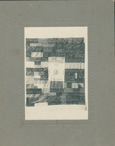
... ...Settlement House...Banner comprising individual signed panels with embroidered signatures surrounding a central rectangle with "From St Andrew's Branch Church to Settlement House" and the Latin motto of Labor Omnia Vincit (Work Conquers All) and a representation of a badge. ...Andrew's Church Ballarat Settlement House Senior Girls' Missionary Union Presbyterian St. ...Banner comprising individual signed panels with embroidered signatures surrounding a central rectangle with "From St Andrew's Branch Church to Settlement House" and the Latin motto of Labor Omnia Vincit (Work Conquers All) and a representation of a badge. Photo was in a collection of St Cuthbert's Presbyterian Church Ballarat photographs, but the title of the group (Senior Girls Missionary Union) has connections with the Baptist Church as well.B & W photographst. andrew's church, ballarat, settlement house, senior girls' missionary union, presbyterian, st. cuthbert's -
 Phillip Island and District Historical Society Inc.
Photograph, 1969
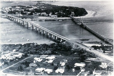
... Black & White photograph of the new Bridge on left with settlement of houses at San Remo at the top of the photograph and settlement of houses at Newhaven at the bottom of the photograph....Phillip Island and District Historical Society Inc. phillip-island-and-the-bass-coast Donated by Jessie Smith (nee Small) two bridges phillip island new bridge at phillip island phillip island san remo jessie smith Black & White photograph of the new Bridge on left with settlement of houses at San Remo at the top of the photograph and settlement of houses at Newhaven at the bottom of the photograph. ...Donated by Jessie Smith (nee Small)Black & White photograph of the new Bridge on left with settlement of houses at San Remo at the top of the photograph and settlement of houses at Newhaven at the bottom of the photograph.two bridges phillip island, new bridge at phillip island, phillip island, san remo, jessie smith -
 Sunshine and District Historical Society Incorporated
Photograph - Sunshine & Albion Pictures
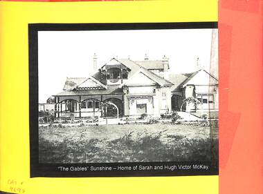
... Hampshire Road Sunshine 28th october 1919 View looking South Along Hampshire Road|Post Office and Residence with pickett fence|Soldier Settlement houses invade paddocks round Camerson's Farm Albion|The Gables Sunshine - Home of Sarah and hugh Victor McKay...Sunshine Albion Aerial Photograph Hampshire Road Sunshine 28th october 1919 View looking South Along Hampshire Road|Post Office and Residence with pickett fence|Soldier Settlement houses invade paddocks round Camerson's Farm Albion|The Gables Sunshine - Home of Sarah and hugh Victor McKay Four copied photographs mounted on orange fold out card Photograph Sunshine & Albion Pictures ...Hampshire Road Sunshine 28th october 1919 View looking South Along Hampshire Road|Post Office and Residence with pickett fence|Soldier Settlement houses invade paddocks round Camerson's Farm Albion|The Gables Sunshine - Home of Sarah and hugh Victor McKaysunshine, albion, aerial photograph -
 Phillip Island and District Historical Society Inc.
Letter, Passage to Australia on the Benalla in 1925 for the Bradley family
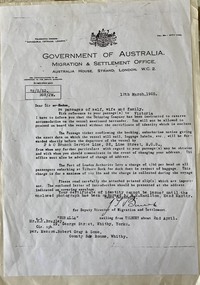
... Migration & Settlement Office. Australia House. 12 March 1925...Migration & Settlement Office. Australia House. 12 March 1925 Black and white photocopy of A4 typed letter from Australia House, London re passages to Australia for Mr E. ...Bradley family settled on Phillip IslandHistoricalBlack and white photocopy of A4 typed letter from Australia House, London re passages to Australia for Mr E. N. Bradley and family Government of Australia. Migration & Settlement Office. Australia House. 12 March 1925bradley family, migration, letters, betty pedley -
 Phillip Island and District Historical Society Inc.
Photograph, 1978/79
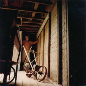
... Photograph of the 18" thick mud brick walls at the core of the old Chicory Kiln on Mr T Woods house, Settlement Road, East Cowes....Settlement Road, East Cowes. Two chicory sowers shown in photograph. Man in photograph is probably Mr T Woods. local history photographs buildings - historical housing rural industry coloured photograph john cook phillip island T Woods Photograph of the 18" thick mud brick walls at the core of the old Chicory Kiln on Mr T Woods house, Settlement Road, East Cowes. ...View of 18" thick mud brick walls in Chicory Kiln. This was built by Mr T Woods approx. 1870, Settlement Road, East Cowes. Two chicory sowers shown in photograph. Man in photograph is probably Mr T Woods.Photograph of the 18" thick mud brick walls at the core of the old Chicory Kiln on Mr T Woods house, Settlement Road, East Cowes.local history, photographs, buildings - historical, housing, rural industry, coloured photograph, john cook, phillip island, t woods -
 Buninyong & District Historical Society
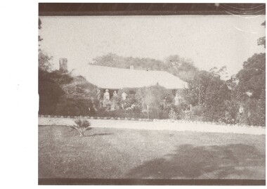
Photograph - Photograph of Scott family homestead, Scotsburn, c.1860, showing established garden, Scott family homestead, Scotsburn, c.1860
... Structures, houses, early settlement...Buninyong & District Historical Society Old Court House, Buninyong Town Hall 313 Learmonth Street Buninyong goldfields Structures, houses, early settlement Scotsburn Scott Family Pencil note on reverse: "Scotsburn. ...Structures, houses, early settlementphoto of photograph, Photograph of Scott family homestead, Scotsburn, c.1860, across driveway which looks to have recent planting of small trees lining it.Pencil note on reverse: "Scotsburn. Land settled 1839 by Andrew Scott. Early homestead."scotsburn, scott family -
 Mt Dandenong & District Historical Society Inc.
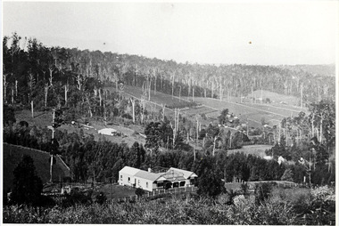
Photograph, The Settlement of Harmony Vale 1913, 1913
... View of the settlement of Harmony Vale taken in 1913 with the guest house Kia Ora, built by George Barber in 1909, in the foreground. ...The settlement of Harmony Vale 1913. The large home in foreground is the Guest House “Kia Ora” owned by George Barber on Lot 25 of the Village Settlement. ...Farndons Community Hall 42 Falls Road Mt Dandenong yarra-valley-and-the-dandenong-ranges george barber kia ora harmony vale barber jeanie richardson richardson child matthew child kia-ora guest house guest house glenrivers The settlement of Harmony Vale 1913. The large home in foreground is the Guest House “Kia Ora” owned by George Barber on Lot 25 of the Village Settlement. ...View of the settlement of Harmony Vale taken in 1913 with the guest house Kia Ora, built by George Barber in 1909, in the foreground. This photograph has a detailed inscription on the back handwritten by John Lundy-Clarke.The settlement of Harmony Vale 1913. The large home in foreground is the Guest House “Kia Ora” owned by George Barber on Lot 25 of the Village Settlement. The house above it to the left was Richardson’s house. The home of Jeanie who had left it when the picture was taken.The buildings furthest to the right of “Kia Ora” were the homestead of Isaac Jeeves of 1863 – 1871 the building furthest right with the black opening in it was the house with the tree fern floor. The flat ground above and left of Isaac’s pointed roof barn is where the creek changed its course in the 1934 flood and destroyed £4000 worth of the Rowse family’s tulip bulbs. Above the flat is Francis Matthew Child’s homestead, in the creek to the right of which can be seen the horizontal structure of the swing bridge to the sawmill of the Childs Bros which cannot be seen but in the forest to the right of the mill (bridge) can be seen a number of logs in the mill yard. The two cleared strips immediately behind Childs home were the Richardson’s original holdings and the house in the gully at the far side of the great clearing is that of the guest house “Glenrivers” belonging to W Lucas and his wife Catherine nee Child. The Richardson homestead “Harmony Vale” is behind the forest trees in the right centre. The picture gives a full view of how the settlement was cut into the centre of the great forest. george barber, kia ora, harmony vale, barber, jeanie richardson, richardson, child, matthew child, kia-ora guest house, guest house, glenrivers -
 The Beechworth Burke Museum
Photograph, 2000
... When gold was discovered at the nearby Spring Creek in February 1852, Woolshed was one of three settlements set up to house miners and their families. ...When gold was discovered at the nearby Spring Creek in February 1852, Woolshed was one of three settlements set up to house miners and their families. ...Woolshed is a small area about five kilometres north west of Beechworth, and almost about 225km north east of Melbourne. When gold was discovered at the nearby Spring Creek in February 1852, Woolshed was one of three settlements set up to house miners and their families. At its peak in 1857, Woolshed was also populated by 29 storekeepers and 14 hotels, as well as the Woolshed State School, which stood near where this photograph was taken. The school often played host to public meetings, as well as a public dance in 1897. The school was subject to some controversy in 1874 when one parent complained about the head of the school in the local newspaper, the Owens and Murray Advertiser, and at least three letters to the editor were exchanged between the two. According to the parent, C. O'Donoghue was not providing enough amusement for the children and was disrespectful to parents and staff. When the State Governor, Sir Reginald Talbot, visited Beechworth in 1906, the school organised a celebratory welcome. The Woolshed State School was ultimately closed in 1922 as miners had exhausted the Spring Creek gold supply and were moving elsewhere. This photograph, taken in about 2000, shows the trees that grew on or near the site of the original school. The Woolshed State School Honour Roll, with a list of the men from the school who served in the First World War, also still exists. It is stored in the Beechworth RSL as of 2015.This photograph is significant for its connection to an important site in Beechworth's gold mining history. Woolshed served a significant community of miners, with a population of at least 138 according to the 1911 census, with families that needed the school site to ensure their children's education. The image is also useful for prompting discussion about how Beechworth has changed over time, with the photograph taken 78 years after the school closed down.A colour rectangular photograph printed on glossy photographic paper.Woolshed State. / School site / 2000 / - remnant trees / / cobeechworth, burke museum, school, education, trees, nature, state school, woolshed, gold mining, teachers, over time, owens and murray advertiser, public meetings, public dance, c. o'donoghue, spring creek, state governor, sir reginald talbot, miners, honour roll, world war 1 -
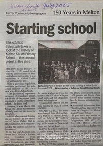 Melton City Libraries
Newspaper, Melton Schools-150 years in Melton, 2005
... By c.1912 the small Melton Railway Station settlement had a boarding house (probably for chaff or sawmill employees), store, a small church and a hall. ...By c.1912 the small Melton Railway Station settlement had a boarding house (probably for chaff or sawmill employees), store, a small church and a hall. ...Melton South "The establishment of a settlement of Melton South was induced by the opening of the railway in 1884. This subsequently prompted a number of industries, initially sawmills, and in the early twentieth century, chaff mills. This development coincided with the Exford ‘Closer Settlement’ estate at the beginning of the new century, boosting local population and produce, and the development of the chaff industry which employed many people in the Melton area. (Around 1912 the government had brought out English migrants to settle the Exford estate.) By c.1912 the small Melton Railway Station settlement had a boarding house (probably for chaff or sawmill employees), store, a small church and a hall. The Melton Valley Golf Club originated near the railway station in 1927 (in 1931 it moved to the present Melton links). In 1910 the community had built the large timber ‘Victoria Hall’, which became the focus of community life for several generations. In August of that same year AR Robertson MP and D McDonald applied for the establishment of a school on land set aside for that purpose by the Closer Settlement Board, near the Melton Railway Station settlement. District Inspector McRae recommended that a school for classes up to Grade 3 be established as an adjunct to the Melton State School. And so SS3717, ‘Melton Railway School’, was established in the leased Victoria Hall on 1st December 1911. Thomas Lang, head master at Melton since 1896, was in charge of both schools. As a ‘prep’ school only, it was necessary that the older Melton Railway Station settlement students travel to Melton SS430 at Unitt Street. Since 1912 local residents had been petitioning for the establishment of a separate school at Melton Railway Station on the grounds that it would be better if all children from the one home could attend the same school, and that the Victoria Hall was unsuitable as a school building. As a result an area of 2 acres - Allotment 8, Parish of Djerriwarrh, Exford Estate - was reserved for a State School on 4th March 1914. However the Department wrote that a school would not be established there in the near future, as ‘there is no likelihood in sight that the Railway Station settlement will increase in importance’. Parents persisted with their petitions to the Education Department, claiming that the Victoria Hall was too large, had no fireplace, that teachers were unable to use the wall for teaching aids, and that, being less than 20 metres away from a chaff mill employing 30 men, was too noisy. The turning point came when in 1920 the Hall Committee decided to increase its rent for the hall. In 1920 Head Teacher Lang advised the Education Department to discontinue SS3717 as an adjunct. The District Inspector supported this recommendation, and the schools separated in 1923. In April of that year 41 children, comprising Grades 1-8, moved into an almost completed brick building on the present site. On the 6th July 1923 the official opening of the school took place; after a ceremonial journey from the Hall to the school, speeches were given by the Hon AR Robertson and the Chief Inspector of Education. Everyone then journeyed back to Victoria Hall for a ‘bountiful repast’. (These dates are at odds with the date of 5th March 1925 given in Blake as the date the children occupied the new SS3717 brick school building. ) A teacher’s residence had been purchased for ₤500 in 1923, and the school’s name was changed to ‘Melton South’ in the same year. Even though the older Melton South pupils would no longer have to travel to the Unitt Street school, an additional brick room was still required at the Melton SS430 in that same year. In 1961 a new room was added to the school. In 1972, at the beginning of Melton’s boom as a satellite town, the number of enrolments was 224. The school has since shared in the exponential growth of the town of Melton, and at the time of its jubilee celebration (1983), 524 pupils were enrolled. Victoria Hall, neglected and vandalised, was demolished in 1992. It had been handed back to the Council on condition that it be replaced by a new hall, with the same name, and was commemorated by a plaque. Apart from the 1923 brick school building, and the railway station, none of the principal early Melton South public sites survive. Few early residential sites remain. (Further research will establish whether the house on the corner of Station Street and the railway line was the original teacher’s residence.)" Melton State School "On 17th May 1858 a State subsidised, combined Denominational School was opened by HT Stokes, with an attendance of about 30 children. This school was conducted in the wooden Melton Combined Protestant Church, situated on ‘a creek flat’ thought to be on the north side of Sherwin Street between Pyke and Byran Streets. It is likely that the Church had been established by 1855 and that the first minister was the Rev. Hampshire, who lived in Cambridge House on the Exford Estate. Ministers of the Protestant denominations were invited to hold services there. As there was only one resident Minister in the town (Presbyterian Mr J Lambie), laymen of the various denominations often spoke on Sundays. In 1863 this building was declared a Common School with the number 430. One of its first and most prominent headmasters was John Corr, who served from 1860 to 1864. Most of Mr Corr’s children also became teachers, including Joseph Corr, at the Rockbank school, and J Reford Corr and WS Corr, headmasters and teachers at numerous prestigious private secondary schools around Australia. John Corr purchased land alongside the school and elsewhere in and near Melton, became secretary and treasurer of the new Cemetery Trust, and by July 1861 was deputy registrar of births, deaths and marriages. He walked three miles every Sunday to teach at the Weslyan Sunday School he had established. Despite good reports from the Education Department Inspector, and burgeoning enrolments, the local school committee recommended the dismissal of, firstly, his wife (from the work mistress position), and then him from the headmaster position. Corr saw his dismissal as an attempt to redirect state aid for education from the Combined Protestant school to the support of the Free Presbyterian Minister Rev James Lambie (by one account the owner of the land on which the Common School was erected), whose son-in-law James Scott subsequently assumed responsibility for the school. Rev Lambie failed in his efforts to keep the existing school, which the Education Department Inspector and the majority of Melton citizens regarded as badly situated and badly built. Following a conditional promise of state aid, local contributors in 1868-69 raised ₤72.10.6 towards the cost of an iron-roofed bluestone rubble building 43 ft x 12 ft. This was erected on a new site of 1.5 acres (the present site). The State contributed ₤120 to the new school, which opened in 1870. A very early (c.1874) photograph of the school shows its headmaster and work mistress / assistant teacher (probably James Scott and his wife Jessie) and its (very young) scholars. Similar photos show pupils in front of the school in c.1903, and 1933. In 1877 a second bluestone room costing ₤297 was added and further land acquired from the Agricultural Society (who only needed it two days a year) to enlarge the schoolground to 3 acres. In the early 1880s an underground tank augmented the school water supply and in 1919 a five-roomed wooden residence was added. During this period the school correspondents often compained that the walls of the bluestone buildings were damp, affecting the plaster. In 1923 a brick room 26 ft 6 in by 24 ft with a fireplace and four rooms facing south, was added, and a corridor built to link the three buildings. This served adequately for the next 40 years. The school bell probably dates to 1883. The school also has a memorial gate (1951) to World War One ex-students, and an honour board to the 64 ex-students who served in the First World War. The school roll fell to 42 in the early post war-years, but was boosted by an influx of migrants, mainly from the UK, from the late 1960s. This presaged the boom in Melton’s development, and the corresponding growth of the school, with timber and temporary classrooms added to the previous masonry ones. An endowment pine plantation established in 1930 augmented the school’s fundraising activities when it was harvested in 1968. Part of the site was planted with eucalyptus trees in 1959. Famous ex-students of the early twentieth century included Hector Fraser (internationally successful shooter) and cyclist Sir Hubert Opperman". The Express Telegraph articles about the history of Melton South and Melton State Schoolseducation -
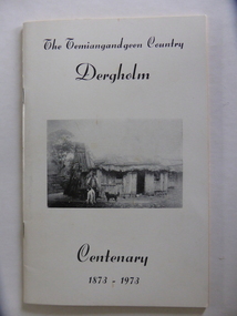 Warrnambool and District Historical Society Inc.
Booklet, The Temiangandeen Country Dergholm, 1973
... This book is of some interest as it provides information on Dergholm, a settlement in the far west of Western Victoria. dergholm victoria alistair roper history of western district of victoria Front Cover: ‘The Temiangandgeen Country, Dergholm Centenary, 1873-1973’ This is a soft cover booklet of 52 pages by Alistair Roper. It has a cream-coloured cover with a black and white photograph of early Dergholm on the front cover (Edward Quinn’s house ...This booklet gives information on the settlement of Dergholm at the time of the centenary of its founding, 1973. The origin of the name Dergholm is unclear but it may have Irish connections. Europeans came to the area in the 1840s and 50s but it was not until the 1870s that the town was surveyed. Dergholm is in the far west of Victoria 334 kilometres from Melbourne and nearby is Dergholm State Park established in 1982. The booklet was produced for the Centenary Back to Dergholm Committee and the local centenary celebrations. This book is of some interest as it provides information on Dergholm, a settlement in the far west of Western Victoria. This is a soft cover booklet of 52 pages by Alistair Roper. It has a cream-coloured cover with a black and white photograph of early Dergholm on the front cover (Edward Quinn’s house). The booklet has printed material - a President’s Message, an Author’s Note, Acknowledgements, Contents, information on the Dergholm area, including a list of local birds, and References. There are several black and white photographs of the area and its people. The book is stapled. Front Cover: ‘The Temiangandgeen Country, Dergholm Centenary, 1873-1973’dergholm victoria, alistair roper, history of western district of victoria -
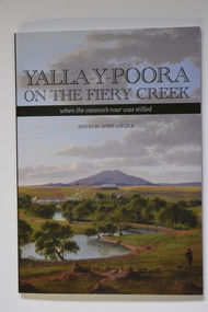 Warrnambool and District Historical Society Inc.
Book - Yalla-Y-Poora On The Fiery Creek, James Affleck, Yalla-Y-Poora On The Fiery Creek when the cannon's roar was stilled, 2023
... Front cover has the Title: "Yalla-Y-Poora On The Fiery Creek when the cannon's roar was stilled" printed over a coloured print of Eugene von Guerard's painting of Yalla-y-Poora; Back cover: Three colour photographs soldier settlement farming family descendants, soldier settler house and tractor. ...Front cover has the Title: "Yalla-Y-Poora On The Fiery Creek when the cannon's roar was stilled" printed over a coloured print of Eugene von Guerard's painting of Yalla-y-Poora; Back cover: Three colour photographs soldier settlement farming family descendants, soldier settler house and tractor. ...Number Six in James Affleck's series of book on Soldier Settlements in Western Victoria. An edited compilation of settler families' own stories, combined with a reincorporation of a previously published history of the area, profiles of local people and organisations illustrated with maps, photographs and poetry136 page softcover book. Front cover has the Title: "Yalla-Y-Poora On The Fiery Creek when the cannon's roar was stilled" printed over a coloured print of Eugene von Guerard's painting of Yalla-y-Poora; Back cover: Three colour photographs soldier settlement farming family descendants, soldier settler house and tractor. Yalla-Y-Poora On The Fiery Creek printed on spine.non-fictionNumber Six in James Affleck's series of book on Soldier Settlements in Western Victoria. An edited compilation of settler families' own stories, combined with a reincorporation of a previously published history of the area, profiles of local people and organisations illustrated with maps, photographs and poetrysoldier settlement, yalla-y-poora -
 Warrnambool and District Historical Society Inc.
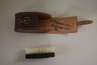
Clothes brush & holder, Mid 20th century
... settlement on the Hopkins Highway about 27 kilometres from Warrambool. George Tomlinson’s grandfather, William Tomlinson , established a farming property at Ballangeich in 1865 and opened a hotel, ‘Half Way House’ on part of the land. ...settlement on the Hopkins Highway about 27 kilometres from Warrambool. George Tomlinson’s grandfather, William Tomlinson , established a farming property at Ballangeich in 1865 and opened a hotel, ‘Half Way House’ on part of the land. ...The brush in this case could have been used as a hair brush or a clothes brush. It is enclosed in a leather case and was probably an item made for travellers. The brush and case belonged to George Tomlinson of Ballangeich. Ballangeich is a small settlement on the Hopkins Highway about 27 kilometres from Warrambool. George Tomlinson’s grandfather, William Tomlinson , established a farming property at Ballangeich in 1865 and opened a hotel, ‘Half Way House’ on part of the land. George Tomlinson’s father, also William, continued to farm in the area and was known as a fine judge of cattle and sheep. This case and brush are of interest as an example of the brushes men used in the mid 20th century. The items are also of interest as they belonged to a member of a well-known Ballangeich family (Tomlinsons).1 This is a piece of brown leather rolled over and stitched with yellow thread to form a container or case. The case has a closing mechanism – a leather strap and metal buckle. .2 Inside the leather case is a brush with a brown Bakelite back with horsehair inserted. ‘G.E. Tomlinson Ballangeich Victoria’men’s toiletries, ballangeich, history of warrnambool -
 Warrnambool and District Historical Society Inc.
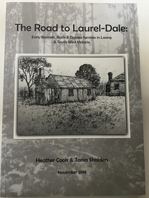
Book, Star Printing Terang Victoria. 978-0-9751360-1-0 et al, The Road to Laurel-Dale, Nov 2014
... It includes a chronological history of the settlement of Laang and will be very useful for researchers as many of the descendants of these families settled in Warrnambool or nearby. laang guinea families of south west victoria bennett families of south west victoria buck families of south west victoria history of warrnambool Early Bennett, Buck & Guinea families in Laang & South West Victoria This is a soft cover book of 340 pages. It has a grey cover with a black and white sketch of a house ...Early Bennett, Buck & Guinea families in Laang & South West VictoriaThis is a soft cover book of 340 pages. It has a grey cover with a black and white sketch of a house on the front and a black and white photograph of a house on the back. There is black printing on the front and the back and the spine of the cover. The book has an introduction, acknowledgements and contents pages, information on the Bennett, Buck and Guinea families, a bibliography and an index. There are many maps, black and white photographs and illustrations and family trees. There are several blank pages at the back of the book for the inclusion of family records and information. non-fictionEarly Bennett, Buck & Guinea families in Laang & South West Victorialaang, guinea families of south west victoria, bennett families of south west victoria, buck families of south west victoria, history of warrnambool -
 Warrnambool and District Historical Society Inc.
Map - Maps, Soldiers Settlement WW2, Circa 1950
... Settlement program, relate to an interesting part of Australian and local history. As such they have historic and social interest and significance. narrapumelap berrambool hopkins hill caramut north morpor chatsworth house east elwood terrinallum moyne falls tarrone caramut soldiers settlers Burrumbeet morgiana grey's estate mornington chaldon meade brung brungle The maps are as follows: .1 Narrapumelap Estate ( Ripon & Hampden) .2 Narrapumelap Estate Part 2 (Villers & Ripon) .3 Narrapumelap Estate Part 3 ( Villiers & Ripon) .4 Burrumbeet Estate ( Ripon) .5 ' Berrambool' Estate 9 Hampden & Villiers) .6 ' Hopkins Hill' Estate Villiers 4011 acres .7 Caramut North No 2 Estate ( Villiers ) .8 ' Morpor' Estate ( Villiers) 4172 acres .9 ' Morgiana' Estate ( Normandy) 3453 acres .10 ' Chatsworth House' ( Villiers) 9341 Acres .11 ' East Elwood' Estate Villiers 2407 acres .12 Grey's Estate ( Mornington) 1151acres .13 ' Rowes Estate' ( Buln Buln Gippsland 733 acres .14 'Tarrone' Estate No 2 Part map .15 'Chaldon Meade' Estate (Bourke) Bulla 517 acres .16 ' Terranallum South' Estate Hampden 3757 acres .17 ' Brung Brungle' Estate Dundas 695 .18 ' Armidale ' Estate ( Dundas)2108 acres .19 ' Moyne Falls' Estate ( Villiers) 627 acres .20' Yulong' Estate 9 Lowan 6321 acres .21 Murray Valley Irrigation District 9 Moira)113 acres .22 Murray Valley Irrigation District 103 acres .23 ' Mount Fyans' Estate ( Hampden) .24 ' Barwidgee ' Estate ( Villiers) 4277 acres .25 'Pine Hills' Estate 2nd portion ( Lowan) 6190 acres A collection of 25 paper maps which relate to to the soldiers settlement post World War 2. ...The soldiers' settlement scheme operated after the first and second world wars in an effort to more closely settle the land and also give opportunities to returned soldiers. Crown land and other larger estates were acquired for the purpose. Most of these maps relate to the area north of Warrnambool where many of the subdivisions were parts of larger estates.These maps pertaining to the Soldiers' Settlement program, relate to an interesting part of Australian and local history. As such they have historic and social interest and significance.A collection of 25 paper maps which relate to to the soldiers settlement post World War 2. Some have details of the people allocated the land and some smaller maps have the printed details of the applicants requirements.Text is black on white paper which in some cases is quite aged. The maps are as follows: .1 Narrapumelap Estate ( Ripon & Hampden) .2 Narrapumelap Estate Part 2 (Villers & Ripon) .3 Narrapumelap Estate Part 3 ( Villiers & Ripon) .4 Burrumbeet Estate ( Ripon) .5 ' Berrambool' Estate 9 Hampden & Villiers) .6 ' Hopkins Hill' Estate Villiers 4011 acres .7 Caramut North No 2 Estate ( Villiers ) .8 ' Morpor' Estate ( Villiers) 4172 acres .9 ' Morgiana' Estate ( Normandy) 3453 acres .10 ' Chatsworth House' ( Villiers) 9341 Acres .11 ' East Elwood' Estate Villiers 2407 acres .12 Grey's Estate ( Mornington) 1151acres .13 ' Rowes Estate' ( Buln Buln Gippsland 733 acres .14 'Tarrone' Estate No 2 Part map .15 'Chaldon Meade' Estate (Bourke) Bulla 517 acres .16 ' Terranallum South' Estate Hampden 3757 acres .17 ' Brung Brungle' Estate Dundas 695 .18 ' Armidale ' Estate ( Dundas)2108 acres .19 ' Moyne Falls' Estate ( Villiers) 627 acres .20' Yulong' Estate 9 Lowan 6321 acres .21 Murray Valley Irrigation District 9 Moira)113 acres .22 Murray Valley Irrigation District 103 acres .23 ' Mount Fyans' Estate ( Hampden) .24 ' Barwidgee ' Estate ( Villiers) 4277 acres .25 'Pine Hills' Estate 2nd portion ( Lowan) 6190 acres narrapumelap, berrambool, hopkins hill, caramut north, morpor, chatsworth house, east elwood, terrinallum, moyne falls, tarrone, caramut soldiers settlers, burrumbeet, morgiana, grey's estate mornington, chaldon meade, brung brungle -
 Warrnambool and District Historical Society Inc.
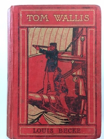
Book, Tom Wallis Louis Becke, Early 20th century
... settlement about 12 kilometres from Warrnambool and was settled in the 1840s by pastoralists prior to the founding of Warrnambool. The Grasmere Presbyterian Church and Sunday School were established in 1898 though services had been held prior to this date in an older church which was converted at that time to house the Sunday School. ...settlement about 12 kilometres from Warrnambool and was settled in the 1840s by pastoralists prior to the founding of Warrnambool. The Grasmere Presbyterian Church and Sunday School were established in 1898 though services had been held prior to this date in an older church which was converted at that time to house the Sunday School. ...This book, ‘Tom Wallis’ written by Louis Becke was awarded as a third prize to Bertie Wilson by the Grasmere Presbyterian Sabbath School in 1910. Grasmere is a small settlement about 12 kilometres from Warrnambool and was settled in the 1840s by pastoralists prior to the founding of Warrnambool. The Grasmere Presbyterian Church and Sunday School were established in 1898 though services had been held prior to this date in an older church which was converted at that time to house the Sunday School. The Sunday School was burnt down in 1914 and later rebuilt. Mr Paton, the Sunday School teacher in 1910, was on the Board of Management of the church in 1911. This book is significant because it is a memento of the Grasmere Presbyterian Sabbath School of 1910. Sunday School attendance was a strong feature of the religious, educational and social life of many children in the 19th century and the first half of the 20th century. Sunday Schools still operate but have fewer children attending in relation to the numbers of Protestant churches adherents. This is a hard cover book of 320 pages plus several pages at the end detailing other books published by the Religious Tract Society. The cover is dark red with an illustration in black, red and grey colours of two sailors aboard a ship. The book was a prize given to Bertie Wilson from the Grasmere Presbyterian Sabbath School in 1910. There are several illustrations (black and white plates) inserted throughout the book. The inscription plate has both printed and handwritten material. The colours on the cover, particularly on the spine, are somewhat faded. Front Cover: ‘Tom Wallis, Louis Becke’. Inscription Plate: ‘Grasmere Presbyterian Sabbath School, Third Prize, Awarded to Bertie Wilson, Mr Paton Teacher, Xmas, 1910’bertie wilson, grasmere presbyterian sunday school, warrnambool -
 Warrnambool and District Historical Society Inc.
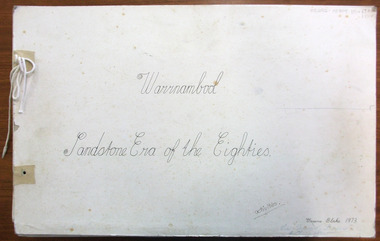
Magazine - Project, Warrnambool: sandstone era of the eighties, 1973
... settlement of some wealth. Hence the trend to build bigger and grander homes. There are numerous other commercial buildings which are built in sandstone and many of the original quarries are still visible around the Warrnambool area. Most of the properties are situated in the central part of Warrnambool. This collection of photographs is a good cross-section of some of the significant homes and buildings of Warrnambool. It also shows how they look 100 years after being built. warrnambool sandstone sandstone houses ...Geographically situated on the coast Warrnambool has large tracts of sedimentary rock, some of which is sandstone. It therefore was a readily available material and as a relatively soft stone it was easily quarried and cut. By the 1880’s Warrnambool had been established for around forty years and was proving to be a settlement of some wealth. Hence the trend to build bigger and grander homes. There are numerous other commercial buildings which are built in sandstone and many of the original quarries are still visible around the Warrnambool area. Most of the properties are situated in the central part of Warrnambool. This collection of photographs is a good cross-section of some of the significant homes and buildings of Warrnambool. It also shows how they look 100 years after being built.A collection of 18 black and white photographs of sandstone houses, mounted on card and tied loosely with string. The addresses of each house are hand-written in black pen beside each photo. Title is written in black pen on cover page.Graeme Blake 1973 in bottom RH corner, Via * Fraser & Chris How in blue pencil.warrnambool, sandstone, sandstone houses, 1880 warrnambool -
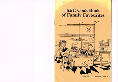 Kiewa Valley Historical Society
Book - Reference Cooking, SEC Cook Book of Family Favourites, Circa 1950
... The Commission had constructed two settlements, Mount Beauty and Bogong Village to house construction workers and their families in a "closed" community. ...The Commission had constructed two settlements, Mount Beauty and Bogong Village to house construction workers and their families in a "closed" community. ...This SEC cook book was produced circa 1950s when the Kiewa Hydro Electricity Scheme and its Commission was in full swing. The Commission had constructed two settlements, Mount Beauty and Bogong Village to house construction workers and their families in a "closed" community. These "closed" communities were for SEC staff and construction workers only. Entry into these villages was restricted to "SEC pass" carrying construction staff and their families. All facilities such as retail, sporting and other community services was provided by the SEC. This created an isolated community in which limited individual choice or administrative family leeway was available. It was a typical company town (live and work for the company). The Company was in the Kiewa Valley constructing power stations for the Kiewa Hydro Electricity Scheme of Victoria. In one way the individual did not need to be concerned with living costs, educational needs for children, and recreational amenities and therefore "normal" community survival /living methods did not apply. This living, although restrictive, was quite simple. When the scheme was completed, in 1961, marking the end of company town, caused some of the employees, who had enjoyed the "controlled" township environment, a fair degree of angst in having the new 'laissez-faire" controls thrust upon them. This was magnified when both Mount Beauty and Bogong Village became meshed into the Bright Shire, vis-a-vis, local government. This cook book is a prime example of " the company is looking after you" and leave the worrying to us. This environment of a "company town", which creates the atmosphere of minimal personal responsibilities, is still present in a few remote mining towns in Australia at the beginning of the 21st Century.This book is a classical example of the psychological control in which the company had its construction workers families living in. The motto of many companies who had employees in isolated regions was "keep them happy". A happy and contented worker is a more productive worker. This was a period in time (1950s to 1970s) when social psychology was gaining recognition in the Australian workforce as well as internationally. At the end of the construction of all the power stations both the Mount Beauty settlement and the Bogong Village became more integrated into the main stream of rural Australia environment. Development of tourism in the region opened up not only interaction with a greater cross section of the ever expanding type of Australian but also the overseas based non rural culture tourist or immigrant. It allowed the intermingling of ideas in a non company controlled environment. The Mount Beauty and Bogong Village has, and even up to the 3000 Millennium, the same housing construction, as was built by the SEC. There has only been a very gradual change to modern domestic architectural home styles. This SEC cookbook has a folded cover with two staples at the spine, securing eight double sided pages. The white pages contain black print and sketches(3), and one black and white photograph (of the author). The front cover is mainly orange in colour with a gradual fading into yellow(at the top). The cover is approximately 210 g/m2 in thickness and each page is approximately 90 g/m2 thick. Front cover: top of page "SEC Cook Book of Family Favourites", in the middle a sketch, black on orange background, of a smiling mother walking from the kitchen to the dining table with a steaming rolled roast and vegetables in one hand and a gravy pot in the other. The furniture and decor relates to the 1950s. Below this sketch is printed"SEC TESTED RECIPES NO. 16" Inside cover: on top of the page is a black and white sketch of a pineapple, apple pear fish with scales, bunch of grapes with leaves a pork roll (head of pig one end and a roll ending on the other, on top of this food arrangement rests a fruit pie. Below this sketch are printed in black print the books contents.The first side of the first page is a black and white photograph Mary Dunne, the SEC Home Service supervisor who provided a signed foreword. The inside back cover has a promotional segment detailing a black and white photograph of a smiling (and happy) couple in the foreground with an electric stove in the distance. The written motto below this photograph is" to Live better -and save money they'll join the Power People. "the new tariff is(1960s) - First 75kWh --6 cents per kWh Next 435 kWh---2.3 cents per kWh Balance --1.7 cents per kWh The rate per killowatt-hour for the final block drops from 2.1 cents to 1.7 cents --a reduction of 19%.cooking recipes circa 1950s, domestic food, sec victoria cook books, recipes circa 1950s -
 RSL Victoria - Anzac House Reference Library and Memorabilia Collection
Photograph, Macleod Repatriation Sanitorium, circa 1914
... RSL Victoria - Anzac House Reference Library and Memorabilia Collection Anzac House 4 Collins Street Melbourne melbourne The former Mont Park/Bundoora Psychiatric and Repatriation Hospitals Complex consisted of seven hospitals on a site of 185 hectares. The site comprising the Mont Park and Strathallen estates was consolidated by the Victorian government by purchase and transfer from the Closer Settlement Board in 1909 . ...The former Mont Park/Bundoora Psychiatric and Repatriation Hospitals Complex consisted of seven hospitals on a site of 185 hectares. The site comprising the Mont Park and Strathallen estates was consolidated by the Victorian government by purchase and transfer from the Closer Settlement Board in 1909 . The Mont Park Hospital commenced in 1910 with the building of the Farm Workers Block . In 1912 the landscape gardener Hugh Linaker was employed to layout the grounds of Mont Park and other State mental hospitals. The other hospitals were gradually split off from the Mont Park administration to form separate entities included among these was the Macleod Repatriation Hospital (1915), An agreement was made with the Defence Department in 1914 for the latter to erect the Mont Park central block (the "Chronic Wards") for use as a Military Hospital, and for it later to revert to the State as portion of Mont Park Hospital. The buildings now known as the Chronic Wards were completed in this way in 1916 and used as the Australian General Hospital no. 16 for the duration of the war. One wing of this building was set aside for mental patients during this period. Silver gelatin photographww1, macleod repatriation sanitorium, mont park -
 Bendigo Military Museum
Programme - PROGRAMME GRACIE FIELDS, August 1945
... Cover has a picture of an island with houses, palm trees and the flags of the UK, Australia and the Straits Settlements. ...Cover has a picture of an island with houses, palm trees and the flags of the UK, Australia and the Straits Settlements. ...The concert was presented by the Army Amenities and RAAF Welfare Fund. Belonged to Victor Henry Evans No 418655 RAAF. Refer Cat No 1760.4.Souvenier Programme for Gracie Fields concert held at Labuan, Borneo. Cover has a picture of an island with houses, palm trees and the flags of the UK, Australia and the Straits Settlements. Programme is folded, foolscap sized with four pages."Monday, Evening, 27th Aug.45". Inside, right bottom corner "Love from Hubby"documents-programmes, concerts, gracie fields -
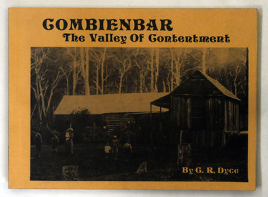 Orbost & District Historical Society
books, Combienbar The Valley of Contentment, 1982
... Dyce. combienbar-history-settlement Three copies of a book of 80 pp titled Combienbar The Valley of Contentment. It has a cream cover with a b/w photograph of a family standing outside a log house (probably late 19th century). ...2169.3 is from the Mary Gilbert Collection. Graham Dyce was a long-time member of Orbost & District Historical Society. His family came from the Combienbar / Club Terrace district.This is a local history written by a local author, Graham R. Dyce.Three copies of a book of 80 pp titled Combienbar The Valley of Contentment. It has a cream cover with a b/w photograph of a family standing outside a log house (probably late 19th century). The book was written by Graham Dyce, Orbost.combienbar-history-settlement -
 Orbost & District Historical Society
ginger jar, Pre 1893 floods in Orbost
... houses were usually built on stilts. They left after the 1893 floods. This object has aesthetic appeal. It is an object which belonged to the very early settlement days of Orbost. ceramics ginger jar container - domestic vase Some Chinese writing to left hand side of roses. ...In the early days of Orbost many Chinese were engaged in land clearing or had arrived when gold was discovered in East Gippsland in the 1840's. They lived in camps along the Marlo Road and houses were usually built on stilts. They left after the 1893 floods.This object has aesthetic appeal. It is an object which belonged to the very early settlement days of Orbost.Huge, ornate Chinese ginger jar. Four raised hand- painted pink roses on front. Jar itself is matt black. Looks more like a vase than a ginger jar. Ceramic.Some Chinese writing to left hand side of roses.ceramics, ginger jar, container - domestic, vase -
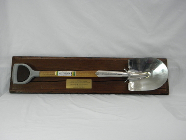 Conservation Volunteers
Memorabilia: Cyclone Sylvaspade, Australian Bicentenary 1988, Cyclone Sylvaspade - Senator Graham Richardson planted a tree using this spade at Sovereign Hill Outdoor Museum to mark ATCV's work at the Australian Bicentennial, 1988 (exact)
... House. Cyclone has been a brand name for a manufacturer of good quality hand tools for over a century. It is likely manufacturing was still done in Australia at the time of manufacture of the Sylvaspade. Much of it has now moved offshore, particuarly to China and Taiwan. This object is historically significant because it is a memento of a significant national event, the 200th anniversary of European settlement ...The spade is a memento of the planting of a tree by the responseible Commonealth Minister to recognise the contribution of ATCV and ATCV volunteers to repair of the Australian environment. At the time ATCV had been operating in Ballarat for six years. ATCV volunteers had planted 192,000 trees from April 1987- March 1988. Senator Richardson was then Minister for the Arts and the Environment in the Hawke ALP Government and on 17 November 1988 he planted a tree using this spade at Sovereign Hill Outdoor Museum (at which ATCV volunteers had planted trees which are (by 2010) fully grown and a significant feature of the site). Peter Hiscock was director of Sovereign Hill as well as President of ATCV and among the most significant leaders of ATCV (now CVA). The spade also symbolises the recovery of ATCV (then a small and struggling community group) from near closure owing to the effects of the 1987 recession. The Cyclone Sylvaspade concept was component project of the Australian Bicentennial celebrations aimed at recognising organisations which had contributed positively to conservation of Australia's environment. The concept was originated and driven by Dr Wilf Crane of the CSIRO Division of Forestry and a highly regarded forester and environmentalist and champion of the cause of rejuvenating Australia's degraded landscape with trees. At the naming of a road after him in Canberra he was described as a: "enthusiast, a man of conviction, action, humility and simplicity". Wilf conceived the project, developed the tree planting spade with Boral Cyclone and the Institute of Foresters of Australia and launched it with the then Governor-General Sir Ninian Stephens at the new Parliament House. Cyclone has been a brand name for a manufacturer of good quality hand tools for over a century. It is likely manufacturing was still done in Australia at the time of manufacture of the Sylvaspade. Much of it has now moved offshore, particuarly to China and Taiwan.This object is historically significant because it is a memento of a significant national event, the 200th anniversary of European settlement and the start of a process of environmental change which has had negative consequences and which demands a commitment to conserving the uniques Australian national environment. It recognised the achievement of ATCV in tree planting over six years. The Cyclone Sylvaspade is a practical memento and having the responsible Commonwealth Minister plant a tree with it was highly symbolic of ATCV's practical commitment to repair of our environment all over Australia. It was also used by the Victorian Premier, Hon John Brumby, to plant a tree at the reopening of the Boral Asphalt plant, Ballarat, in April 2010. The spade is No. 12 of a limited edition. This item is a functional tree planting spade called a "Cyclone Sylvaspade", mounted on a block of wood with a plaque. The handle of the spade is made of grey plastic, the haft is light, stained wood, and the blade is manufactured to resemble silver and has engravings. It was donated by the Boral company and presented to ATCV by the Minister of Arts and the Environment, Senator Graham Richardson after he had planted a tree to mark the occasion at Sovereign Hill Outdoor Museum, BallaratOn the stem of the spade here is a label showing the logo of the Boral company which reads "SYLVASPADE Tree Planting Spade - Made in Australia." On the blade is engraved "Cyclone - NUMBER 0012 - SYLVASPADE - 1788-1988" together with the logo of the Australian Bicentennial Authority. The spade is mounted on a sturdy polished wooden board on which there is a brass-coloured plate bearing the words: "PRESENTED BY SENATOR THE HON GRAHAM RICHARDSON TO AUSTRALIAN TRUST FOR CONSERVATION VOLUNTEERS IN RECOGNITION OF THEIR CONTRIBUTION TO THE ENVIRONMENT 17TH NOVEMBER 1988 DONATED BY BORAL LIMITED"of, trust, ballarat, memento, australian, australia, environment, conservation, atcv, for, volunteers, cyclone, sylvaspade, senator graham richardson, 1788 1988 australian, bicentennial, boral, spade, sovereign hill, 17th november 1988, 1988, minister for arts and environment, tree planting, institute, foresters, dr, wilf, crane -
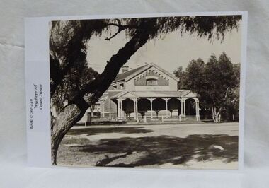 Wycheproof & District Historical Society Inc.
Photograph, Wycheproof Court House, (estimated); mid to late 19th century
... House is No H 1656 on the Victorian Heritage Register. It is the one of only two buildings with this listing in Wycheproof, and characteristic of the type of building constructed in the early days of settlement in Wycheproof. ...The Court House opened as a court of petty sessions in 1890 and closed as a court in the early 1980s. It is now a 'Place of Deposit' for paper based products, maps, documents and photographs, and the home of the Wycheproof and District Historical Society Inc. The local Craft Group met at the Court House between 1982 and 2010. The Buloke Shire Council oversees the maintenance of the building.The Court House is No H 1656 on the Victorian Heritage Register. It is the one of only two buildings with this listing in Wycheproof, and characteristic of the type of building constructed in the early days of settlement in Wycheproof. The architecture is of aesthetic value and although some restoration work has taken place to maintain the structure, it remains in good condition and with some of the original furnishings intact.Sepia print of the Wycheproof-Court-House. It was constructed during 1889/90 and commissioned on September 23,1890 as a court-of-petty-sessions. A simple form of Court House built of red-face-brick but embellished by stepped brick work in the principal gable and by the traverse veranda with elaborate frieze and gabled pavilions that protect the street facade. The roof is of slate.Nonecourt house, wycheproof heritage 1890, petty sessions, building, red face brick, gabled pavilions -
 Wycheproof & District Historical Society Inc.
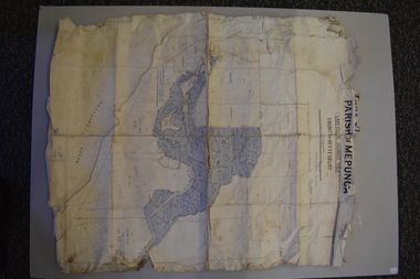
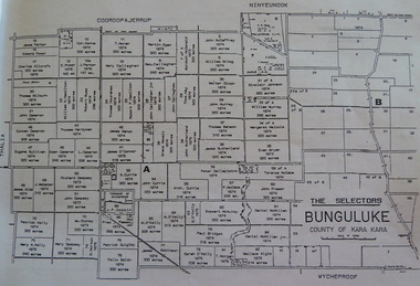
Bunguluke Map, Bunguluke District In 1923, 27.2.1923
... settlement as recorded, December 5, in the Charlton "Mercury". It reports that in that year Draper's Store, Hotel and Post Office and residence at Bunguluke North was totally destroyed by fire. For years now there has been little sign of community life with houses...settlement as recorded, December 5, in the Charlton "Mercury". It reports that in that year Draper's Store, Hotel and Post Office and residence at Bunguluke North was totally destroyed by fire. For years now there has been little sign of community life with houses ...By 1881 Bunguluke was a small settlement as recorded, December 5, in the Charlton "Mercury". It reports that in that year Draper's Store, Hotel and Post Office and residence at Bunguluke North was totally destroyed by fire. For years now there has been little sign of community life with houses few and far between and acreages have gone into larger holdings. The map references land blocks and owners for that era.This important map shows the local land ownership and local features that existed in 1923. This is a photocopied black and white map of Bunguluke in the County of Kara Kara, Number L5149. Marked - Photo Lithographed by W.J. Butson 27.2.1923. The details include numbers of allotments, property owners, roads, rivers. The boundaries marked are the Parish of Jeruk, Parish of Wycheproof, Parish of Cooroopajerrup. Wycheproof township location is shown with the Scale of Chains. Bunguluke maps for other years are also in the collection.map, bunguluke, jeruk, wycheproof, cooroopajerrup -
 Glen Eira Historical Society
Plan - LEMPRIERE AVENUE
... settlement. Streetscape Lempriere Avenue ‘Greenmeadows Gardens’ Meadow Street Alston Grove Californian bungalow style Fences Spanish Mission style ‘Greenmeadows House Lempriere W. ...One item about this location 1/Excerpts (5 pages) from Andrew Wards Heritage Study vol 2, 3.6 on Lempriere Avenue and ‘Greenmeadows Gardens’ Historic Area include street plan and general view of Roselle Estate’, Greenmeadows Garden. Included in his description is mention of a large eucalypt in ‘Greenmeadows Gardens’ which pre-dates European settlement.streetscape, lempriere avenue, ‘greenmeadows gardens’, meadow street, alston grove, californian bungalow style, fences, spanish mission style, ‘greenmeadows house, lempriere w. g., meadow street, clarke william senior, ‘greenmeadows’, trees, balaclava road, orrong road, allan road, meadow street, lempriere john, kirton mr, dickson and yorston (pty ltd), lempriere ruby l mrs, dickson g c, yorston j c, st kilda east, east st kilda, roselle estate, east st kilda, east st kilda riding -
 Eltham District Historical Society Inc
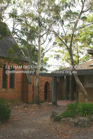
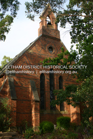
Photograph - Digital Photograph, Alan King, St Margaret's Anglican Church, Pitt Street, Eltham, 30 January 2008
... settlement was part of the parish of St Johns Heidelberg. Isolation and the tedious, time consuming journey between Heidelberg and Eltham resulted in the Eltham community taking its own action. The original vicarage (Dendy House...settlement was part of the parish of St Johns Heidelberg. Isolation and the tedious, time consuming journey between Heidelberg and Eltham resulted in the Eltham community taking its own action. The original vicarage (Dendy House ...St Margaret’s Church of England was officially opened on December 12, 1861. It is the oldest intact church building in Eltham. At the time it was known as Christ Church until its consecration in 1871, when it was completely free of debt (£1,700 for the church and parsonage) despite the district’s poverty. This was largely due to the free labour and materials, including locally made bricks donated by local artisans and others. The church is historically significant because it is the oldest church in the former Shire of Eltham and has associations with the philanthropist and founder of Brighton, Henry Dendy (who donated the land on which the church is built), the architect Nathaniel Billing and the prominent local builder, George Stebbing. The church is architecturally and aesthetically significant because it is constructed in the Gothic Revival style with several stained-glass windows of various dates and is also a very early use of polychromatic brickwork in Victoria. Billing was one of the first Melbourne architects to employ polychromatic brickwork and an important early architect. The rear wall was intended to be temporary. A major feature of the design is the large buttresses with long, steeply graded upper faces. The overall design is well proportioned with the surface brick patterns relieving an otherwise austere design. The church is spiritually and socially significant because it has been an important place of worship for the people of Eltham for almost 150 years. The land on which the buildings stand was donated by Henry Dendy. Dendy arrived in Melbourne in 1841 after purchasing in England eight square miles at Brighton under the system of "special surveys". After this land passed out of his hands, Dendy moved about Victoria, visited England, then returned to settle in Eltham where he purchased a flour mill. Dendy chaired the meeting held in 1860 “for the purpose of devising such means as may be expedient for the establishment of a Church of England in the township of Eltham”. He became chairman and treasurer of the church committee. Unlike the establishment of many early churches in Victoria where a vicar was appointed to a parish and later a permanent church was constructed, the population at Eltham initiated action to build a church. The nearest church at that time was at Heidelberg and the Eltham settlement was part of the parish of St Johns Heidelberg. Isolation and the tedious, time consuming journey between Heidelberg and Eltham resulted in the Eltham community taking its own action. The original vicarage (Dendy House) at the rear of the church is also an important part of the cultural significance of this place because it is connected to the church and the development of the Eltham area. Together, the church and the vicarage are aesthetically significant because they form a significant streetscape feature. The mud-brick community hall designed by Robert Marshall was added in 1978. In 2014 the original temporary rear wall was removed as part of a modern extension designed by Architects Atelier Wagner and constructed by Conrad Construction and Management. Covered under Heritage Overlay, Nillumbik Planning Scheme. National Trust of Australia (Victoria) State significance Victorian Heritage Published: Nillumbik Now and Then / Marguerite Marshall 2008; photographs Alan King with Marguerite Marshall.; p67 St Margaret’s Anglican Church in Pitt Street, Eltham, which officially opened on December 12, 1861, is the oldest intact church building in Eltham.1 With the nearby courthouse and police station, it was one of the first permanent community buildings in the district. The church and vicarage are on the Register of the Heritage Council of Victoria and the National Trust of Australia – Victoria. The church is important as an early example of polychrome brickwork by the notable architect Nathaniel Billings. It is also notable for its historic associations with the early settlement of the Shire of Eltham and its connection with Henry Dendy, Brighton’s founder.2 Henry Dendy, who lived in Eltham much longer than at Brighton, chaired the original meeting which planned the church, and he donated the half-acre (0.2ha) site. Dendy had arrived in Melbourne in 1841 after buying eight square miles (20.7sq km) at Brighton while in England. After this land passed out of his hands, he eventually settled in Eltham where he bought a flour mill, west from the corner of Main Road and Pitt Street (then called Brewery Lane). The vicarage was named Dendy House after him. The Eltham settlers were unusual in initiating the establishment of a church. Usually in Victoria a vicar was appointed to a parish and then a permanent church was constructed. But then, the nearest church was at Heidelberg, which was a tedious and time-consuming journey. St Margaret’s builder was a local, George Stebbing, who also constructed the former Methodist, later Uniting, Church at John Street and the Shillinglaw Cottage near Eltham’s Central Park. It is believed the first Anglican Bishop of Melbourne, Bishop Perry, dedicated the church. After the ceremony he joined in the festivities at the nearby pub and a bill was sent to the parish for teas taken there by the bishop with other participants. The first vicar was the Reverend Robert Mackie from 1864 to1866. St Margaret’s Church was originally called Christ Church until its consecration in 1871, when it was completely free of debt (£1700 pounds for the church and parsonage) despite the district’s poverty. This was largely due to the free labour and materials, including local bricks, donated by local artisans and others. St Margaret’s Church is in the Gothic Revival tradition with a buttressed nave, paired lancet windows, porch and bell-cote. It was the first polychromatic brick church in Australia, using softly contrasting coloured brickwork.3 Billing was one of the first architects to introduce polychrome brickwork into Melbourne. His original drawings for St Margaret’s survive in a folio of his architectural work. However the church’s brickwork is more subdued than in his drawings. About half the windows – those in clear glass with gold borders – are original. The stained glass windows were made much later, but the one behind the altar is thought to be the oldest in the Diamond Valley. It was to be temporary until the congregation could afford to extend the church. In the early 1960s the original cedar pews were replaced by blonde timber pews and the originals were sold to restaurants and to private individuals. Eminent local sculptor Matcham Skipper created a crucifix for the church. A major addition was made in 1978, when the weatherboard hall was replaced by a mud-brick hall. Made of local material, it was designed by local architect and a former shire president Robert Marshall. The mud-brick hall reflects the style of building in Eltham of the late 1970s and for which Eltham is well-known. Perhaps because its earthy tones blend with the surrounding environment, the hall sits well with the church building. St Margaret’s membership has included economist and ABC chairman, Richard Downing; political commentator, diplomat and academic, William Macmahon Ball; Eltham civic leader, Charles Wingrove; artist, Peter Glass; and Eltham’s first postmaster, Frederick Falkiner.This collection of almost 130 photos about places and people within the Shire of Nillumbik, an urban and rural municipality in Melbourne's north, contributes to an understanding of the history of the Shire. Published in 2008 immediately prior to the Black Saturday bushfires of February 7, 2009, it documents sites that were impacted, and in some cases destroyed by the fires. It includes photographs taken especially for the publication, creating a unique time capsule representing the Shire in the early 21st century. It remains the most recent comprehenesive publication devoted to the Shire's history connecting local residents to the past. nillumbik now and then (marshall-king) collection, eltham, st margaret's anglican church, st margaret's church, st margarets church hall, christ church -
 Eltham District Historical Society Inc
Photograph - Digital Photograph, Alan King, St Margaret's Anglican Church, Pitt Street, Eltham, 30 January 2008
... settlement was part of the parish of St Johns Heidelberg. Isolation and the tedious, time consuming journey between Heidelberg and Eltham resulted in the Eltham community taking its own action. The original vicarage (Dendy House...settlement was part of the parish of St Johns Heidelberg. Isolation and the tedious, time consuming journey between Heidelberg and Eltham resulted in the Eltham community taking its own action. The original vicarage (Dendy House ...St Margaret’s Church of England was officially opened on December 12, 1861. It is the oldest intact church building in Eltham. At the time it was known as Christ Church until its consecration in 1871, when it was completely free of debt (£1,700 for the church and parsonage) despite the district’s poverty. This was largely due to the free labour and materials, including locally made bricks donated by local artisans and others. The church is historically significant because it is the oldest church in the former Shire of Eltham and has associations with the philanthropist and founder of Brighton, Henry Dendy (who donated the land on which the church is built), the architect Nathaniel Billing and the prominent local builder, George Stebbing. The church is architecturally and aesthetically significant because it is constructed in the Gothic Revival style with several stained-glass windows of various dates and is also a very early use of polychromatic brickwork in Victoria. Billing was one of the first Melbourne architects to employ polychromatic brickwork and an important early architect. The rear wall was intended to be temporary. A major feature of the design is the large buttresses with long, steeply graded upper faces. The overall design is well proportioned with the surface brick patterns relieving an otherwise austere design. The church is spiritually and socially significant because it has been an important place of worship for the people of Eltham for almost 150 years. The land on which the buildings stand was donated by Henry Dendy. Dendy arrived in Melbourne in 1841 after purchasing in England eight square miles at Brighton under the system of "special surveys". After this land passed out of his hands, Dendy moved about Victoria, visited England, then returned to settle in Eltham where he purchased a flour mill. Dendy chaired the meeting held in 1860 “for the purpose of devising such means as may be expedient for the establishment of a Church of England in the township of Eltham”. He became chairman and treasurer of the church committee. Unlike the establishment of many early churches in Victoria where a vicar was appointed to a parish and later a permanent church was constructed, the population at Eltham initiated action to build a church. The nearest church at that time was at Heidelberg and the Eltham settlement was part of the parish of St Johns Heidelberg. Isolation and the tedious, time consuming journey between Heidelberg and Eltham resulted in the Eltham community taking its own action. The original vicarage (Dendy House) at the rear of the church is also an important part of the cultural significance of this place because it is connected to the church and the development of the Eltham area. Together, the church and the vicarage are aesthetically significant because they form a significant streetscape feature. The mud-brick community hall designed by Robert Marshall was added in 1978. In 2014 the original temporary rear wall was removed as part of a modern extension designed by Architects Atelier Wagner and constructed by Conrad Construction and Management. Covered under Heritage Overlay, Nillumbik Planning Scheme. National Trust of Australia (Victoria) State significance Victorian Heritage Published: Nillumbik Now and Then / Marguerite Marshall 2008; photographs Alan King with Marguerite Marshall.; p67This collection of almost 130 photos about places and people within the Shire of Nillumbik, an urban and rural municipality in Melbourne's north, contributes to an understanding of the history of the Shire. Published in 2008 immediately prior to the Black Saturday bushfires of February 7, 2009, it documents sites that were impacted, and in some cases destroyed by the fires. It includes photographs taken especially for the publication, creating a unique time capsule representing the Shire in the early 21st century. It remains the most recent comprehenesive publication devoted to the Shire's history connecting local residents to the past. nillumbik now and then (marshall-king) collection, eltham, st margaret's anglican church, st margaret's church, christ church -
Bendigo Historical Society Inc.
Map - PARISH OF EGERTON, 19/03/1894
... History House 11 Mackenzie Street Bendigo goldfields MAP Bendigo settlement on lands act 1893 Egerton Settlement on lands act 1893. ...Map: Parish of Egerton, Settlement on Lands Act 1893, County of Bendigo. Parish plan ( number 245 in Map Cupboard 1)map, bendigo, settlement on lands act 1893, egerton, settlement on lands act 1893. -
 Bendigo Historical Society Inc.
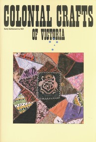
Book - COLONIAL CRAFTS OF VICTORIA, 1978
... History House 11 Mackenzie Street Bendigo goldfields ART crafts Colonial Crafts of Victoria. Early settlement to 1921. ...Colonial Crafts of Victoria. Early settlement to 1921. Examples of early craftwork to make goods for a specific purpose.art, crafts -
 Bendigo Historical Society Inc.
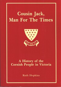
Book - COUSIN JACK MAN FOR THE TIMES, 1994
... History House 11 Mackenzie Street Bendigo goldfields VICTORIA History cornish people Settlement in Victoria industry and manufacture farming etc. ...Cousin Jack, Man for the Times. A history of the Cornish People in Victoria. Between the pages is a short page of notes written by Alex Stone, listing topics and page numbers at which these topics maybe found.Ruth Hopkinsvictoria, history, cornish people, settlement in victoria, industry and manufacture, farming, etc.