Showing 34 items matching "sherbrooke forest"
-
 Victorian Aboriginal Corporation for Languages
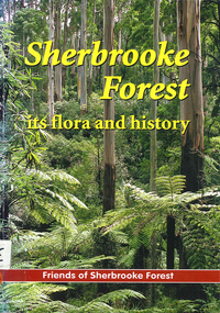
Book, Friends of Sherbrooke Forest, Sherbrooke Forest : its flora and history, 2000
... Sherbrooke Forest : its flora and history...Friends of Sherbrooke Forest...Victorian Aboriginal Corporation for Languages 33 Saxon Street Brunswick melbourne Dandenong Ranges National Park indigenous vascular plants weed management Maps, b&w illustrations, b&w photographs, colour photographs Notes on plants in the area, including swamp/water plants. Sherbrooke Forest : its flora and history Book Friends of Sherbrooke Forest ...Notes on plants in the area, including swamp/water plants.Maps, b&w illustrations, b&w photographs, colour photographsdandenong ranges national park, indigenous vascular plants, weed management -
 Ringwood and District Historical Society
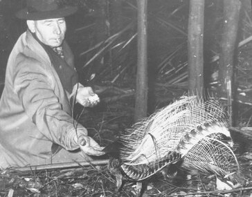
Photograph, Les Mabus, Bedford Rd, Ringwood, feeding lyre bird in Sherbrooke Forest. c1950
... Les Mabus, Bedford Rd, Ringwood, feeding lyre bird in Sherbrooke Forest. c1950....Written on back of photograph: "Les Mabus, Bedford Rd, Ringwood feeding lyre bird in Sherbrooke Forest"....Ringwood and District Historical Society 125A Warrandyte Road Ringwood North melbourne Written on back of photograph: "Les Mabus, Bedford Rd, Ringwood feeding lyre bird in Sherbrooke Forest". Black and white photograph Les Mabus, Bedford Rd, Ringwood, feeding lyre bird in Sherbrooke Forest. c1950. ...Black and white photographWritten on back of photograph: "Les Mabus, Bedford Rd, Ringwood feeding lyre bird in Sherbrooke Forest". -
 Southern Sherbrooke Historical Society Inc.
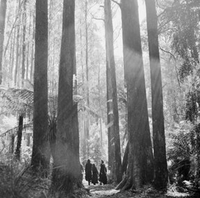
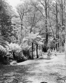
Photograph, Sherbrooke Forest 1968
... Sherbrooke Forest 1968...Black and white photo showing a group of four or more people walking in Sherbrooke Forest between mountain ash trees. Treeferns are also visible. ...Created by the Australian News and Information Bureau. Sherbrooke Forest 1968 Photograph ...Black and white photo showing a group of four or more people walking in Sherbrooke Forest between mountain ash trees. Treeferns are also visible. Created by the Australian News and Information Bureau. -
 Save the Dandenongs League Inc.
Archive (item), Save the Dandenongs League Incorporated, Sherbrooke Forest Park, and Other Brochures
... Sherbrooke Forest Park, and Other Brochures...Sherbrooke Forest Park, and Other Brochures Archive Save the Dandenongs League Incorporated ... -
 Bendigo Historical Society Inc.
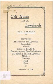
Book - ALEC H CHISHOLM COLLECTION: BOOK ''AT HOME WITH THE LYREBIRDS'' BY D.J.MORGAN
... ... SHERBROOKE FOREST...ALEC H CHISHOLM COLLECTION. 12 page booklet on the habits, life etc of the lyrebird as witnessed by the author at Sherbrooke Forest, Dandenong Ranges, Victoria, between 1932 and 1935. ...History House 11 Mackenzie Street Bendigo goldfields BOOKS Collections ornithology ALEC H CHISHOLM COLLECTION D.J.MORGAN LYREBIRDS SHERBROOKE FOREST ORNITHOLOGY D. J. Morgan Booklet. ...Booklet. ALEC H CHISHOLM COLLECTION. 12 page booklet on the habits, life etc of the lyrebird as witnessed by the author at Sherbrooke Forest, Dandenong Ranges, Victoria, between 1932 and 1935. List of contents on front cover. Printed in 1936 by W. D. Vaughan, Kew, Victoria. Catalogue sticker ''2202 MOR'' on front cover. Handwritten in ink on front cover ''With the author's compliments''.D. J. Morganbooks, collections, ornithology, alec h chisholm collection, d.j.morgan, lyrebirds, sherbrooke forest, ornithology -
 Southern Sherbrooke Historical Society Inc.
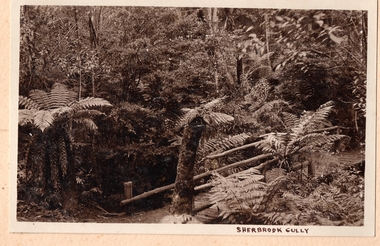
Photograph, Sherbrooke Gully
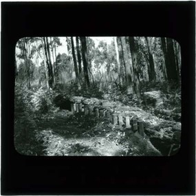
... Fern gully in Sherbrooke Forest. A bridge with long log sides crosses a creek. ...Southern Sherbrooke Historical Society Inc. 127 Colby Drive Belgrave Heights 3160 yarra-valley-and-the-dandenong-ranges Fern gully in Sherbrooke Forest. A bridge with long log sides crosses a creek. ...Fern gully in Sherbrooke Forest. A bridge with long log sides crosses a creek. Tree ferns edge the track. -
Federation University Historical Collection
Reports, Big Cat sightings (dates), 1989
... ...sherbrooke forest...Barker Library (top floor) Mount Helen goldfields australian mythical animals collection david waldron dse big cats panthers pumas nuggety gippsland black cats tasmanian tiger marysville wood's point thylacine south gippsland felid gippsland big cat kelvin healey peter hall sherbrooke forest woodside walaces flat mountain lion heyfield mt taylor walhalla mt selma warrnambool kyneton korumburra canadian forest grampians panton hill beaconsfield apollo bay forrest victoria valley rapanyup dargo inglewood doncaster east tidal river cape bridgewater walkerville dooen st arnaud lake bung bong mitta mitta moliagul emerald kinglake cape otway dereel leonard's hill daylesford korweinguboora lal lal noojee eltham lancefield trentham daisy hill tanjil south wonthaggi cockatoo warrenheip greendale howqua lake buchan melville caves portland mt elephant morwell navarre yarram yandoit moonambel maryborough taravale coghill's creek trentham carisbrook inglewood warrenmang yarragon creswick emerald stawel clunes majorca heathcote talbot daylesford newham broadford peter chapple Research of dated sightngs of Big cats in Victoria from 1868-1989. ...Research of dated sightngs of Big cats in Victoria from 1868-1989. australian mythical animals collection, david waldron, dse, big cats, panthers pumas, nuggety, gippsland, black cats, tasmanian tiger, marysville, wood's point, thylacine, south gippsland, felid, gippsland big cat, kelvin healey, peter hall, sherbrooke forest, woodside, walaces flat, mountain lion, heyfield, mt taylor, walhalla, mt selma, warrnambool, kyneton, korumburra, canadian forest, grampians, panton hill, beaconsfield, apollo bay, forrest, victoria valley, rapanyup, dargo, inglewood, doncaster east, tidal river, cape bridgewater, walkerville, dooen, st arnaud, lake bung bong, mitta mitta, moliagul, emerald, kinglake, cape otway, dereel, leonard's hill, daylesford, korweinguboora, lal lal, noojee, eltham, lancefield, trentham, daisy hill, tanjil south, wonthaggi, cockatoo, warrenheip, greendale, howqua, lake buchan, melville caves, portland, mt elephant, morwell, navarre, yarram, yandoit, moonambel, maryborough, taravale, coghill's creek, trentham, carisbrook, inglewood, warrenmang, yarragon, creswick, emerald, stawel, clunes, majorca, heathcote, talbot, daylesford, newham, broadford, peter chapple -
 Mont De Lancey
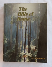
Book, Arthur Paul Wizenreid et al, The Hills of Home: A Bicentennial History of the Shire of Sherbrooke, 1988
... ...Sherbrooke Forest - Victoria...This is a local history of the Shire of Sherbrooke in Victoria, Australia, documenting its development. The cover front has a beautiful green toned scene of the forest trees with the title printed at the top in pale green lettering outlined in black. ...Australian history Dandenong Ranges - history Dandenong Ranges - tourism and travel Tourism - Victoria Sherbrooke Forest - Victoria This 374-page work traces the history of the Shire of Sherbrooke in Victoria, Australia. ...This 374-page work traces the history of the Shire of Sherbrooke in Victoria, Australia. It covers the region's development from before European colonisation up to the bicentennial year. Sherbrooke Forest is a prominent 800+ hectare section of the Dandenong Ranges National Park, located about 40 km east of Melbourne. Famous for its towering Mountain Ash trees and dense fern gullies, it is a premier location for spotting wild lyrebirds, wallabies, and cockatoos. The forest offers popular hiking trails, including the walk to Sherbrooke Falls, and multiple picnic areas like Grants Picnic Ground.This is a local history of the Shire of Sherbrooke in Victoria, Australia, documenting its development. The cover front has a beautiful green toned scene of the forest trees with the title printed at the top in pale green lettering outlined in black. The author is printed in yellow at the bottom. The title page lists the publishing details with Original pen and ink drawings by Jillienne Winzenried printed at the bottom. There is an Acknowledgements page, Foreword, Contents and Introduction. At the back, Chapter 18 is a Prologue, followed by three Appendices, Endnotes and an Index. Throughout the book are black and white photos as well as coloured ones, maps, illustrations, lists, advertisements. The back cover has a photograph with a black surround depicting a woman seated looking at autumn leaves. Pp. 374 non-fictionThis 374-page work traces the history of the Shire of Sherbrooke in Victoria, Australia. It covers the region's development from before European colonisation up to the bicentennial year. Sherbrooke Forest is a prominent 800+ hectare section of the Dandenong Ranges National Park, located about 40 km east of Melbourne. Famous for its towering Mountain Ash trees and dense fern gullies, it is a premier location for spotting wild lyrebirds, wallabies, and cockatoos. The forest offers popular hiking trails, including the walk to Sherbrooke Falls, and multiple picnic areas like Grants Picnic Ground. australian history, dandenong ranges - history, dandenong ranges - tourism and travel, tourism - victoria, sherbrooke forest - victoria -
Southern Sherbrooke Historical Society Inc.
Oral history - Belgrave, "Memories of Belgrave"
... ...sherbrooke forest...Southern Sherbrooke Historical Society Inc. 127 Colby Drive Belgrave Heights 3160 yarra-valley-and-the-dandenong-ranges belgrave sherbrooke forest puffing billy Photocopy of a newsletter article, dated 2 May 1995. ...Photocopy of a newsletter article, dated 2 May 1995. Marcus Tarrant, a Black Rock resident, writes about Belgrave c. 1925. The newsletter is dated 22 Jul 1995.belgrave, sherbrooke forest, puffing billy -
Save the Dandenongs League Inc.
Document (item), Save the Dandenongs League Incorporated, Save the Dandenongs League Correspondence 1984-1985 [Part 8 of 14]: Conserv Groups ACF, FOSF Etc
... ...Friends of Sherbrooke Forest...Australian Conservation Foundation Friends of Sherbrooke Forest Save the Dandenongs League Correspondence 1984-1985 [Part 8 of 14]: Conserv Groups ACF, FOSF Etc. ...australian conservation foundation, friends of sherbrooke forest -
Federation University Historical Collection
Reports, Unexplained animal kills and sighting, 1997
... ...Sherbrooke forest...The folder was collected for research being conducted by David Waldron. australian mythical animals collection david waldron DSE big cats panthers pumas nuggety gippsland black cats tasmanian tiger marysville wood's point thylacine south gippsland felid gippsland big cat dna kelvin healey peter hall Sherbrooke forest woodside Walaces Flat mountain lion Bairnesdale heyfield mt taylor walhalla mt Selma warrnambool tasmanian tiger kyneton korumburra canadian forest grampians panton hill beaconsfield apollo bay forrest Folder of reports unexplained animal kills and sighting in VIctoria Unexplained animal kills and sighting Reports ...The folder or correspondence is the result of a Freedom of Informaition request made to the Department of Sustainability and Environment in 2011. The folder was collected for research being conducted by David Waldron.Folder of reports unexplained animal kills and sighting in VIctoria australian mythical animals collection, david waldron, dse, big cats, panthers pumas, nuggety, gippsland, black cats, tasmanian tiger, marysville, wood's point, thylacine, south gippsland, felid, gippsland big cat, dna, kelvin healey, peter hall, sherbrooke forest, woodside, walaces flat, mountain lion, bairnesdale, heyfield, mt taylor, walhalla, mt selma, warrnambool, tasmanian tiger, kyneton, korumburra, canadian forest, grampians, panton hill, beaconsfield, apollo bay, forrest -
 Southern Sherbrooke Historical Society Inc.
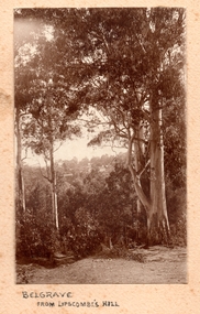
Photograph, Belgrave from Lipscombe's Hill
... Presumably taken from near Sherbrooke Forest....Presumably taken from near Sherbrooke Forest. Belgrave from Lipscombe's Hill Photograph ...Sepia photo shows a track through bush at Belgrave. Tall gum trees in foreground. Treed hill in background with houses visible among the trees. Presumably taken from near Sherbrooke Forest. -
 Southern Sherbrooke Historical Society Inc.
Photograph
... Black and white photo of Sherbrooke Forest in 1968. A group of people in summer attire are walking along an open track between treeferns and tall gum trees. ...Southern Sherbrooke Historical Society Inc. 127 Colby Drive Belgrave Heights 3160 yarra-valley-and-the-dandenong-ranges Black and white photo of Sherbrooke Forest in 1968. A group of people in summer attire are walking along an open track between treeferns and tall gum trees. ...Black and white photo of Sherbrooke Forest in 1968. A group of people in summer attire are walking along an open track between treeferns and tall gum trees. Created for the Australian News and Information Bureau. -
 Southern Sherbrooke Historical Society Inc.
Photograph, A Bend In The Road, Belgrave, c. 1920s
... Photo shows a bend in the road, Belgrave, most likely on Monbulk Road below Sherbrooke Forest. An unmade road crosses a small gully. ...Southern Sherbrooke Historical Society Inc. 127 Colby Drive Belgrave Heights 3160 yarra-valley-and-the-dandenong-ranges A BEND IN THE ROAD hand-wriiten in ink below the photo on the album page Photo shows a bend in the road, Belgrave, most likely on Monbulk Road below Sherbrooke Forest. An unmade road crosses a small gully. ...Photo shows a bend in the road, Belgrave, most likely on Monbulk Road below Sherbrooke Forest. An unmade road crosses a small gully. A group of three or so young people are leaning over the bridge railing. The area is heavily treed. A BEND IN THE ROAD hand-wriiten in ink below the photo on the album page -
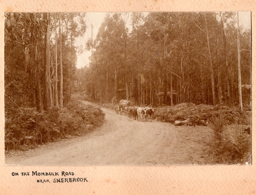 Southern Sherbrooke Historical Society Inc.
Photograph, On the Monbulk Road near Sherbrooke
... Heavy timber both sides of the road, most likely present-day Sherbrooke Forest. c.1920....Heavy timber both sides of the road, most likely present-day Sherbrooke Forest. c.1920. On the Monbulk Road near Sherbrooke Photograph ...Photo shows a team of cattle (bullocks, cows or steers) hauling a log down to the sawmill. A huge piece of timber is clearly seen chained to the dray. Heavy timber both sides of the road, most likely present-day Sherbrooke Forest. c.1920. -
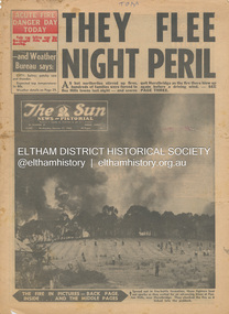 Eltham District Historical Society Inc
Newspaper - Newspaper articles, Sun News-Pictorial, They Flee Night Peril, The Sun News-Pictorial, Wednesday, January 17, p1, 1962
... ...Sherbrooke Park Forest...Aldridge Loughnan’s Hill Ringwood Woori Yallock Leslie Ockwell Linda Ockwell Kalorama Healesville Daylesford Fire Damage – buildings Wye River Portland Eganstown Ballarat Sherbrooke Park Forest Forest Commission Headquarters Kallista R.T. ...Various news articles pertaining to the January 1962 Victorian bushfires in the Dandenong and Healesville districts which by the third day had encompassed large areas of the State. Specific Eltham Shire districts mentioned include Panton Hill and Hurstbridge on page 1, Warrandyte on page 2, 3, 4 and 5, Hurstbridge, Smith’s Gully, Kinglake on page 3 and 4, Strathewen, Kangaroo Ground, Panton Hill, St. Andrews, Smith’s Gully on page 4 and Pound Bend, Smith’s Gully and Warrandyte on pages 20-21 • They Flee Night Peril, p1 (Illust.) • Their grim picnic; A flash fire strikes, p2 (Illust.) • Night of terror as towns quitted, p3 • Fought till he dropped, p3 (Illust.) • Rain in fire area, p3 • Wye River town goes, p3 • Black Friday Hero Dies In Fire; with wife, grandsons, p4 • Surrounded!, p4 (Illust.) • Main street houses ablaze, p4 • Hurstbridge is evacuated, p4 • Scores jump in river at Warrandyte, p5 • Hills people leave homes, p5 • “Fire” cry at Parlt., p5 • Blind – he’s safe now, p5 (Illust.) • Police Chief Runs Battle, p7 • From Fire Front: Hospital treats 34, p7 • Firms send help, p7 • Tragedy and Ruin: Third Day; Ferntree Gully; Warrandyte; Pound Bend; Smiths Gully; Escape for 18, pp20-21 (Illust.) • Church was a haven for the hurt, weary, p39 (Illust.) • A home is lost, p40 (Illust.) tom fielding collection, victorian bushfires - 1962, victorian bushfires – 1962, panton hill, hurstbridge, five ways crossroads, warrandyte south, dandenongs, upwey, mt. evelyn, monbulk, olinda, sassafras, st. andrews, warrandyte, christmas hills, yarra river, mitcham, whitehorse roiad, donvale, park orchards, metropolitan fire chief, w.t. aldridge, loughnan’s hill, ringwood, woori yallock, leslie ockwell, linda ockwell, kalorama, healesville, daylesford, fire damage – buildings, wye river, portland, eganstown, ballarat, sherbrooke park forest, forest commission headquarters, kallista, r.t. seaton, montrose, yallourn, central gippsland, smith’s creek, black friday, geoffrey ockwell, ronald ockwell, preston town hall, e.j. tenner, strathewen, kangaroo ground, eric farnsworth, adele farnsworth, robin farnsworth, roy cleland, ann cleland, belgrave, sassfras, kaloramalice commissioner porter, mansfield, box hill hospital, pound bend, ferntree gully, ferntree gully state school, w. carew, ann quinton -
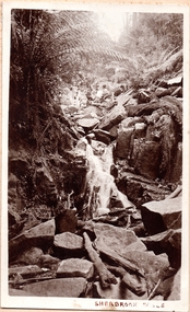 Southern Sherbrooke Historical Society Inc.
Photograph, Sherbrooke Falls
... Photo of the falls in Sherbrooke Forest. Huge amount of large rocks in and around creek bed. ...Southern Sherbrooke Historical Society Inc. 127 Colby Drive Belgrave Heights 3160 yarra-valley-and-the-dandenong-ranges Photo of the falls in Sherbrooke Forest. Huge amount of large rocks in and around creek bed. ...Photo of the falls in Sherbrooke Forest. Huge amount of large rocks in and around creek bed. Ferns grow up sides of banks. Low volume of water indicates dry season. At the top of the falls a man sits with another person who appears to be a woman. c.1920. -
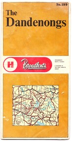 Emerald Museum & Nobelius Heritage Park
Map - Map of the Dandenongs, The Paul Hamlyn Group, c. 1970s
... The other side includes a street index, a list of tourist sites, a list of walking tracks, a map of Sherbrooke Forest, and a map of key approaches from the city to the Dandenongs....The other side includes a street index, a list of tourist sites, a list of walking tracks, a map of Sherbrooke Forest, and a map of key approaches from the city to the Dandenongs. ...George Broadbent was a Geelong-born cyclist record-holder, who produced from 1896 the most comprehensive and detailed maps of Victoria until his death in October 1947. His son had taken over map production in 1945. This map of the Dandenongs c 1970s details tourist sites and walking tracks. This map shows streets and walking tracks and tourist sites significant in the Dandenongs c. 1970s.Front of fold-out map titled 'The Dandenongs No. 199', produced by Broadbents. Folded out, one side is a street map of the Dandenongs. The other side includes a street index, a list of tourist sites, a list of walking tracks, a map of Sherbrooke Forest, and a map of key approaches from the city to the Dandenongs.On front: ' No. 199 / The / Dandenongs / Broadbents / Broadbents / Maps & Guides / A DIVISION OF / THE PAUL HAMLYN / GROUP'broadbents, dandenongs, 1970s, tourist sites, walking tracks -
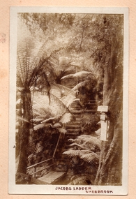 Southern Sherbrooke Historical Society Inc.
Photograph, Jacobs Ladder, Sherbrooke
... Photo of Jacob's Ladder in Sherbrooke Forest. Looks to be water under the bridge at the bottom of the photo. ...Southern Sherbrooke Historical Society Inc. 127 Colby Drive Belgrave Heights 3160 yarra-valley-and-the-dandenong-ranges Photo of Jacob's Ladder in Sherbrooke Forest. Looks to be water under the bridge at the bottom of the photo. ...Photo of Jacob's Ladder in Sherbrooke Forest. Looks to be water under the bridge at the bottom of the photo. Very steep wooden steps going up through ferns. There is a wooden seat halfway up the visible steps, to the right of the steps. There are three signs attached to a tree on the right side of the photo near the creek. The sun is shining on the ferns. -
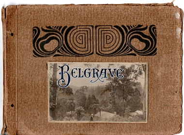 Southern Sherbrooke Historical Society Inc.
Album - Handmade photographic album, Belgrave
... The photos are of local beauty spots in the Sherbrooke Forest, Lipscombe's Hill, Biffin's Hill and Selby trestle bridge areas. ...The photos are of local beauty spots in the Sherbrooke Forest, Lipscombe's Hill, Biffin's Hill and Selby trestle bridge areas. ...This album is made of strong cardboard now held together by ribbon and it contains 17 images taken around Belgrave in the early 1920s. The photographer is unknown but it could have been Charles Ladd, engraver, farmer, and amateur photographer, who lived with his family in Dewhurst. The photos are of local beauty spots in the Sherbrooke Forest, Lipscombe's Hill, Biffin's Hill and Selby trestle bridge areas. Several people appear in various photos and appear to be a group of family and/or friends. -
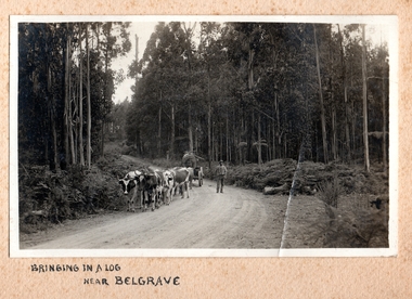 Southern Sherbrooke Historical Society Inc.
Photograph, Bringing in a log near Belgrave
... Most likely Sherbrooke Forest. Road bends to left behind team then possibly to the right, going up a small rise. ...Most likely Sherbrooke Forest. Road bends to left behind team then possibly to the right, going up a small rise. ...Photo of a worker bringing in a log on a dray with what appear to be narrow steel wheels. Dray is being pulled by eight or ten steers or small bullocks. Heavy bush and tall, straight timber on side of the road. Most likely Sherbrooke Forest. Road bends to left behind team then possibly to the right, going up a small rise. The man could be well-known bullocky Bill Martin. He is dressed in a wellworn hat, a pale shirt with sleeves rolled up, and darker pants, and is carrying a long, slender stick or possibly a whip in his right hand. -
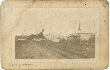 Emerald Museum & Nobelius Heritage Park
Postcard - Postcard of 'Main Road - Gembrook'
... forest to the east from early colonial settlement days. The opening of the narrow-gauge train line in 1900 assisted the expansion of this industry. This postcard is circa 1900s. This and other postcards and photos came from the estate of David Moyle (1938-2015) who was a police officer in Emerald during late 1960s-early 1970s, and subsequently at Belgrave in the early 1980s. David Moyle was closely associated with the now defunct Sherbrooke...forest to the east from early colonial settlement days. The opening of the narrow-gauge train line in 1900 assisted the expansion of this industry. This postcard is circa 1900s. This and other postcards and photos came from the estate of David Moyle (1938-2015) who was a police officer in Emerald during late 1960s-early 1970s, and subsequently at Belgrave in the early 1980s. David Moyle was closely associated with the now defunct Sherbrooke ...Many sawmills operated in Gembrook in the forest to the east from early colonial settlement days. The opening of the narrow-gauge train line in 1900 assisted the expansion of this industry. This postcard is circa 1900s. This and other postcards and photos came from the estate of David Moyle (1938-2015) who was a police officer in Emerald during late 1960s-early 1970s, and subsequently at Belgrave in the early 1980s. David Moyle was closely associated with the now defunct Sherbrooke Historical Association.This postcard is significant because of its evocation of Gembrook's early timber industry. it is also part of a collection belonging to a community member who had a close association with a local historical society.Sepia postcard with rounded corners featuring photograph of unmade Main Road in Gembrook. The Ranges Hotel which opened in 1902 is just visible on the left. The view is towards the west.On front at bottom, printed: 'MAIN ROAD - GEMBROOK' On back printed at the top: 'POST CARD' Underneath that is printed: 'SPACE FOR CORRESPONDENCE' and 'SPACE FOR ADDRESS' On back is handwritten message: 'J Brooks / 16 notts Sawmills / well fixed / Gembrook'david moyle, police, emerald, belgrave, timber mills, gembrook, brooks, 1900s -
Southern Sherbrooke Historical Society Inc.
Information folder - Lockwood House
... Southern Sherbrooke Historical Society Inc. 127 Colby Drive Belgrave Heights 3160 yarra-valley-and-the-dandenong-ranges lockwood house elvery family guesthouses Folder containing items pertaining to the history of Lockwood House, Belgrave Heights. Contents: -notes, hand-written, on holidays in Belgrave Heights, 6 sheets on Ansett memo pad. -typescript, "Holidays In The Dandenongs" -printed sheets, "Doongala Forest ...Folder containing items pertaining to the history of Lockwood House, Belgrave Heights. Contents: -notes, hand-written, on holidays in Belgrave Heights, 6 sheets on Ansett memo pad. -typescript, "Holidays In The Dandenongs" -printed sheets, "Doongala Forest Reserve", Dept of Conservation, Forests & Lands, includes map of Doongalla walking tracks, hand-written on back "Doongala/751 1717/Open week days except/Thursday./Open weekends by appointment" -5 Certificates of Title for parcels of land included in Lockwood Estate.lockwood house, elvery family, guesthouses -
Southern Sherbrooke Historical Society Inc.
Information Folder - geology of Dandenong Ranges
... Southern Sherbrooke Historical Society Inc. 127 Colby Drive Belgrave Heights 3160 yarra-valley-and-the-dandenong-ranges dandenong ranges geology of dandenong ranges Information folder containing items pertaining to the geology of the Dandenong Ranges, including material prepared by Betty Hotchin for a talk to the Kallista Tourism course. Contents:-/typescript, re. basic features/photocopy, "The Dandenongs volcano and settlement in its great forest ...Information folder containing items pertaining to the geology of the Dandenong Ranges, including material prepared by Betty Hotchin for a talk to the Kallista Tourism course. Contents:-/typescript, re. basic features/photocopy, "The Dandenongs volcano and settlement in its great forest" by John Lundy-Clarke, published by Lilydale and District Historical Society/2 maps, Dandenong Ranges/List of reference materialdandenong ranges, geology of dandenong ranges -
Southern Sherbrooke Historical Society Inc.
Information folder - Dandenong Ranges Music Council, 2000
... Southern Sherbrooke Historical Society Inc. 127 Colby Drive Belgrave Heights 3160 yarra-valley-and-the-dandenong-ranges birdsland reserve john shortis dandenong ranges music council upper yarra community forests program Program for the performance of "The Ballad Of Birdsland", a community music event taking place at Birdsland Reserve, Belgrave, and at Belgrave Heights Convention Centre, Belgrave Heights, on 28 May 2000. ...Program for the performance of "The Ballad Of Birdsland", a community music event taking place at Birdsland Reserve, Belgrave, and at Belgrave Heights Convention Centre, Belgrave Heights, on 28 May 2000. Includes project description, profiles of creative team and principle musicians, list of items and list of participants. A5 blue booklet, 3 copies. Program and lyrics of The Fire Cycle, performed at the Belgrave Heights Convention Centre, 8 & 9 October 2005, by DRMC in conjunction with UYCFP, local schools, CFA brigades, local musicians and performers, and the Southern Sherbrooke Historical Society. A5 coloured booklet. Certificate presented to Susan Heywood-Downard for her contribution to "The Fire Cycle"birdsland reserve, john shortis, dandenong ranges music council, upper yarra community forests program -
Southern Sherbrooke Historical Society Inc.
Information folder - Local Government Amalgamations 1986, 1985 & 1986
... Sherbrooke-Lilydale boundary changes -article "Ranges future is still clouded", The Free Press 30 April 1986, re. proposal to form a shire covering Dandenong Ranges -article "Sherbrooke wins first battle in restructuring", by Peter Janky, Free Press, 30 April 1986, re. ceding of forest areas by Knox to Sherbrooke....Sherbrooke-Lilydale boundary changes -article "Ranges future is still clouded", The Free Press 30 April 1986, re. proposal to form a shire covering Dandenong Ranges -article "Sherbrooke wins first battle in restructuring", by Peter Janky, Free Press, 30 April 1986, re. ceding of forest areas by Knox to Sherbrooke. ...Folder containing information pertaining to the Local Government amalgamations in Victoria in 1986. Contents: -copy of "Local Government Act 1958, appointment of a division of the local government commission and referral of proposals to the division", 8 pages and 6 explanatory maps -memo, dated 21 November 1985 from K. E. Matson, General Manager, Shire of Sherbrooke, to all councillors, re. local government commission and municipal restructure, 12 pages including map -letter, Warwick Heine, CEO, Shire of Lilydale to K. E. Matson, General Manager, Shire of Sherbrooke, dated 16 April 1986, re. local government restructure (2 copies) -booklet, "The Restructure of Local Government in Victoria: Options Paper Eastern Melbourne Segment", Local Government Commission June 1986, 24 pages -article "Residents to fight land deal", Knox-Sherbrooke News, 17 June1986, re. proposed annexation of part of Lysterfield by Berwick Council -article "Knox and Sherbooke align for the future", The Trader, 30 April 1986, re. alignment of common boundary -article "Boundary changes 'just a joke'", by Cheryl Critchley, Knox-Sherbrooke News, 6 May 1986 , re. Knox-Sherbrooke boundary alignment -article "Border clash worsens", by Peter Janky, Mountain District Free Press, 7 May 1986, re. Sherbrooke-Lilydale boundary changes -article "Ranges future is still clouded", The Free Press 30 April 1986, re. proposal to form a shire covering Dandenong Ranges -article "Sherbrooke wins first battle in restructuring", by Peter Janky, Free Press, 30 April 1986, re. ceding of forest areas by Knox to Sherbrooke.shire of sherbrooke, shire of lilydale, knox city council, berwick shire council -
 Southern Sherbrooke Historical Society Inc.
Information folder - German Club
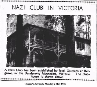
... Southern Sherbrooke Historical Society Inc. 127 Colby Drive Belgrave Heights 3160 yarra-valley-and-the-dandenong-ranges belgrave world war 2 germans nazi party Information folder containing material pertaining to the German Club, Belgrave. Contents: -article, NAZI CLUB - Victorian Camp - Opened By Hitler, Cairns Post, 25 Apr 1938 -German home in forest ...Information folder containing material pertaining to the German Club, Belgrave. Contents: -article, NAZI CLUB - Victorian Camp - Opened By Hitler, Cairns Post, 25 Apr 1938 -German home in forest, The Argus, 27 Apr 1938 -photo, Australian Nazi Party room, Dandenong Ranges -sketch, Arbeits-heim in Belgrave (Tecoma) Vic, sketch signed Karl Muffler, 5-4-91 -article with photo, Nazi Club in Victoria, Burnie's Advocate, 2 May 1938 -article, A German holiday camp, The Horsham Times, 3 May 1938 -article, Nazi propaganda denied, Echuca's Riverina Herald, 3 May 1938 -letter to editor, Nazi Club, The Argus, 3 May 1938 -article, Cat Out Of The Bag, Burnie Advocate, 4 May 1938 -article, German Club at Belgrave - Students Propose Raid, Port Pirie Recorder. 4 May, 1938 -article, No Trouble at Club, The Argus, 9 May 1938 -article, Bush Fires in May! - German Club near Belgrave saved, The Age, 16 May 1938 -letter to editor, Nazi propaganda, Burnie Advocate, 6 Jun 1838 -article, Close Watch Kept On Operations, South Australi's The Advertiser, 12 Jul 1939 -article, Nazi Club at Belgrave, The Age, 7 Sep 1939 -article, German Club closed, Cairns Post, 8 Sep 1939 -article, German Club property, 12 Sep 1939 -article, Belgrave's "Nudist" Colony, Healesville & Yarra Glen Guardian, 22 Jun 1940 -article, German Club at Belgrave, The Age, 5 Mar 1942belgrave, world war 2, germans, nazi party -
Southern Sherbrooke Historical Society Inc.
Typescript|Photograph - copy
... Southern Sherbrooke Historical Society Inc. 127 Colby Drive Belgrave Heights 3160 yarra-valley-and-the-dandenong-ranges albert a'vard a'vard family micawber park alf a'vard the valley Single page typescript composed by Jill A'Vard, and single page with four copies of photographs. -Micawber Park Picnic Ground Belgrave c. 1934 shows a forest ...Single page typescript composed by Jill A'Vard, and single page with four copies of photographs. -Micawber Park Picnic Ground Belgrave c. 1934 shows a forest scene, a creek with a large tree fallen across it, a wooden footbridge, and a man in a hat standing on the bridge. Black and white photo. -Micawber Tea Rooms Belgrave shows a group of two men and two women standing on the verandah of a building which bears the signs "Refreshments", "Hot water" and "Micawber Tea Rooms". Black and white photo. -Ted & Lil A'Vard sitting in their lounge room at Micawber Park c. 1935 shows a middle-aged couple in armchairs in front of a brick fireplace. The mantelpiece holds several items including a clock. Behind the woman, on the right side, is a wooden stand with a green vase holding an arrangement of autumn-coloured flowers and foliage. The man is holding a book and there is possibly a dark dog at the woman's feet. Black and white photo which has been coloured in the top right corner (flower vase and edge of mantelpiece). -Alf & Maggie A'Vard's "The Valley" is a Rose Series postcard P. 1488, showing a house in a forest setting with a group of people on the verandah.albert a'vard, a'vard family, micawber park, alf a'vard, the valley -
 Southern Sherbrooke Historical Society Inc.
Photograph, Termite fence line test, Belgrave
... Southern Sherbrooke Historical Society Inc. 127 Colby Drive Belgrave Heights 3160 yarra-valley-and-the-dandenong-ranges Black and white photo, c.1923-32, taken from a lantern slide, showing a termite fence line test along a termite-infested log. Log is surrounded by open forest ...Black and white photo, c.1923-32, taken from a lantern slide, showing a termite fence line test along a termite-infested log. Log is surrounded by open forest. -
 Southern Sherbrooke Historical Society Inc.
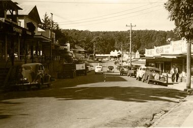
Photograph - Main Road, Belgrave, early 1950s
... Southern Sherbrooke Historical Society Inc. 127 Colby Drive Belgrave Heights 3160 yarra-valley-and-the-dandenong-ranges Belgrave Main Street around early 1950's. Chemist would have been Mr. Brent. Forest ...Belgrave Main Street around early 1950's. Chemist would have been Mr. Brent. Forest Frocks was run by Mr. Buchanan. U.S. Motors visible at end of street on right; bus stop there. Guest house on left hand side corner of Terrys Avenue. Street is busy.