Showing 58 items matching "silvan"
-
 Mont De Lancey
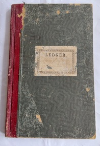
Book, Norman Bros, Silvan Progress Association Statement of Accounts, Unknown
... Silvan Progress Association Statement of Accounts...This was used for local records in the Silvan area in Victoria in the early 1900's, 1939 to be exact....This blank book was used by the Silvan Progress Association in 1914 as written on the front cover in copperplate writing. ...Henderson 12 Henderson Hill Rd Silvan 3795' ...This was used for local records in the Silvan area in Victoria in the early 1900's, 1939 to be exact. ...This blank book was used by the Silvan Progress Association. Inside the book starts at page 64 so the pages 1 - 63 may well have been used in 1914 and they have been torn out. There is an entry on Page 173, the last page, for Expenses for 1915 & 1916 for the Silvan Progress Assoc.The Leger was used as a Statement of Accounts Processed Strawberries Apl - June 1939 and for other statements too. The last entry was completed on Nov 24 1939. Pp.173A large green cloth paper wavy patterned covered Norman Bros., Leger Book with burgundy tape on the spine. This blank book was used by the Silvan Progress Association in 1914 as written on the front cover in copperplate writing. Inside the book starts at page 64 so the pages 1 - 63 may well have been used in 1914 and they have been torn out. There is an entry on Page 173, the last page, for Expenses for 1915 & 1916 for the Silvan Progress Assoc.The Leger was used as a Statement of Accounts Processed Strawberries Apl - June 1939 and for other statements too. The last entry was completed on Nov 24 1939. Pp.173non-fictionThis blank book was used by the Silvan Progress Association. Inside the book starts at page 64 so the pages 1 - 63 may well have been used in 1914 and they have been torn out. There is an entry on Page 173, the last page, for Expenses for 1915 & 1916 for the Silvan Progress Assoc.The Leger was used as a Statement of Accounts Processed Strawberries Apl - June 1939 and for other statements too. The last entry was completed on Nov 24 1939. Pp.173account books, accounts, business accounts, business records, documents, account records, financial records -
 Slovenian Association Melbourne
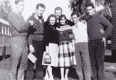
Slovenian picnic, photo, Slovenian picnic at Silvan, Miro, Karlo, Ivan, Dario, Rudi, Jenny, Anica, Early 1960s
... Slovenian picnic at Silvan, Miro, Karlo, Ivan, Dario, Rudi, Jenny, Anica...Social gathering of Slovenians at Slovenian Association picnic at Silvan early 1960s...Silvan, Victoria, Australia..., Anica Cinc (Kregar) Slovenian picnic at Silvan, Miro, Karlo, Ivan, Dario, Rudi, Jenny, Anica Slovenian picnic, photo ...Social gathering of Slovenians at Slovenian Association picnic at Silvan early 1960sSlovenians gathering at a picnicBlack and white photo of a group of young Slovenians on a social outing; Slovenian picnic at Sylvan. Miro Krsevan, Karlo Strancar, Ivo Mihelj, Darjo Ziberna, Jenny ? , Anica Cinc (Kregar)social gathering of slovenians, slovenian association melbourne -
 Slovenian Association Melbourne
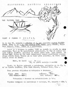
Invitation to a dance, Invitation to an outing and a dance at Silvan 1962, 1962
... Invitation to an outing and a dance at Silvan 1962......Silvan...Invitation to an outing and a Slovenian dance on 26th August 1962 at Silvan Dam. The invitation promises a transport by bus and an early return - before midnight - to make a connection by public transport home....Slovenian Association Melbourne 82 Ingrams Road Research melbourne Invitiation dance Silvan 1962 Hand drawn pictures and typewritten text Invitation to an outing and a Slovenian dance on 26th August 1962 at Silvan Dam. ...Invitation to an outing and a Slovenian dance on 26th August 1962 at Silvan Dam. The invitation promises a transport by bus and an early return - before midnight - to make a connection by public transport home.Hand drawn pictures and typewritten textinvitiation, dance, silvan, 1962 -
 Mont De Lancey
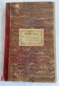
Book, Norman Bros, Silvan Progress Association Minute Book, Unknown
... Silvan Progress Association Minute Book...The third document, dated 17th May 1928, is a copy of 13 typed pages from the Shire of Lilydale to The Hon. Secretary, Silvan Hall Committee, Silvan. It includes a list of names of Guarantors and witnesses....The third document dated 17th May 1928, is a copy of 13 typed pages from the Shire of Lilydale to The Hon. Secretary, Silvan Hall Committee, Silvan. It includes a list of names of Guarantors and witnesses....Silvan Progress Association Minute Book Book Norman Bros., ...This blank book was used by the Silvan Progress Association. Minutes of the first meeting were taken Sat March 1th 1916 and the last minutes were held in the Library Mechanics Hall on 5th Oct. 1922. The book is filled with Minutes of the monthly meetings and has three paper insertions - a Mont De Lancey Wine List with three wines and their prices per bottle. A second quite damaged paper is: Wandin ? Progress Association Inaugurated 26th Oct 1912. The meeting was held Jan 11, 1913. It lists the monthly meetings and minutes taken up to March 28 1913. The third document is a copy of 13 typed pages from the Shire of Lillydale to Mr. S. Bradley, Hon. Secretary, Silvan Hall Committee, Silvan suggesting to the Committee that the attached plan for the maintenance and betterment for the hall be forwarded to the Public Health Department for approval. It includes a list of names of Guarantors and witnesses.A large red, blue and cream wavy lined paper patterned covered Norman Bros., Minute Book with burgundy tape on the spine. This blank book was used by the Silvan Progress Association. Minutes of the first meeting were taken Sat March 1th 1916 and the last minutes were held in the Library Mechanics Hall on 5th Oct. 1922. The book is filled with Minutes of the monthly meetings and has threeo paper insertions - a Mont De Lancey Wine List with three wines and their prices per bottle. A second quite damaged paper is: Wandin ? Progress Association Inaugurated 26th Oct 1912. The meeting was held Jan 11, 1913. It lists the monthly meetings and minutes taken up to March 28 1913. The third document, dated 17th May 1928, is a copy of 13 typed pages from the Shire of Lilydale to The Hon. Secretary, Silvan Hall Committee, Silvan. It includes a list of names of Guarantors and witnesses.non-fictionThis blank book was used by the Silvan Progress Association. Minutes of the first meeting were taken Sat March 1th 1916 and the last minutes were held in the Library Mechanics Hall on 5th Oct. 1922. The book is filled with Minutes of the monthly meetings and has three paper insertions - a Mont De Lancey Wine List with three wines and their prices per bottle. A second quite damaged paper is: Wandin ? Progress Association Inaugurated 26th Oct 1912. The meeting was held Jan 11, 1913. It lists the monthly meetings and minutes taken up to March 28 1913. The third document is a copy of 13 typed pages from the Shire of Lillydale to Mr. S. Bradley, Hon. Secretary, Silvan Hall Committee, Silvan suggesting to the Committee that the attached plan for the maintenance and betterment for the hall be forwarded to the Public Health Department for approval. It includes a list of names of Guarantors and witnesses.meetings, reports, proceedings, minutes of meetings -
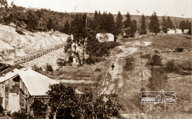
 Eltham District Historical Society Inc
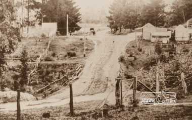
Photograph, Upper Diamond Creek, Silvan Gully area, 1911
... Upper Diamond Creek, Silvan Gully area...Two colour photograph copies of originals of Main Road through Silvan Gully area upper Diamond Creek prior to construction of the railway in 1911...Eltham District Historical Society Inc 728 Main Rd Eltham melbourne upper diamond creek wattle glen hurstbridge silvan gully hurstbridge road kinglake road heielberg kinglake road Two colour photograph copies of originals of Main Road through Silvan Gully area upper Diamond Creek prior to construction of the railway in 1911 Upper Diamond Creek, Silvan Gully area Photograph ...Two colour photograph copies of originals of Main Road through Silvan Gully area upper Diamond Creek prior to construction of the railway in 1911upper diamond creek, wattle glen, hurstbridge, silvan gully, hurstbridge road, kinglake road, heielberg kinglake road -
 Mt Dandenong & District Historical Society Inc.
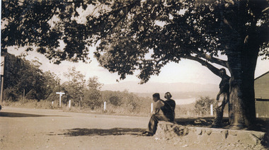
Photograph, FiveWays, Kalorama Looking Towards Silvan Dam, c1930
... FiveWays, Kalorama Looking Towards Silvan Dam....Close up of elm tree at FiveWays with a man and woman seated on stone bank and a man standing under the tree. Silvan Dam visible in distance. (2 copies)...Silvan Dam visible in distance. (2 copies) FiveWays, Kalorama Looking Towards Silvan Dam. ...Close up of elm tree at FiveWays with a man and woman seated on stone bank and a man standing under the tree. Silvan Dam visible in distance. (2 copies)fiveways, kalorama, silvan dam -
 Southern Sherbrooke Historical Society Inc.
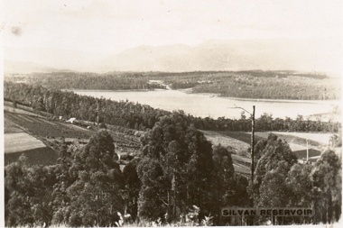
Postcard, Silvan Reservoir
... Silvan Reservoir...Sepia-toned postcard featuring distant view of Silvan Dam. The middle ground shows cleared land all set out for agriculture, houses also visible. c. early 1930s...Southern Sherbrooke Historical Society Inc. 127 Colby Drive Belgrave Heights 3160 yarra-valley-and-the-dandenong-ranges Sepia-toned postcard featuring distant view of Silvan Dam. The middle ground shows cleared land all set out for agriculture, houses also visible. c. early 1930s Silvan Reservoir Postcard ...Sepia-toned postcard featuring distant view of Silvan Dam. The middle ground shows cleared land all set out for agriculture, houses also visible. c. early 1930s -
 Eltham District Historical Society Inc
Negative - Photograph, Silvan Gully area, Upper Diamond Creek, c.1911
... Silvan Gully area, Upper Diamond Creek...Silvan Gully area. The railway was extended from Eltham to Hurstbridge in 1912....Eltham District Historical Society Inc 728 Main Rd Eltham melbourne Silvan Gully area. The railway was extended from Eltham to Hurstbridge in 1912. upper diamond creek silvan gully Railway construction Wattle Glen Kodak Safety 5035 Roll of 35mm colour negative film, 4 strips Silvan Gully area, Upper Diamond Creek Negative Photograph ...Silvan Gully area. The railway was extended from Eltham to Hurstbridge in 1912.Roll of 35mm colour negative film, 4 stripsKodak Safety 5035upper diamond creek, silvan gully, railway construction, wattle glen -
 Eltham District Historical Society Inc
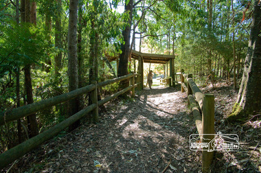
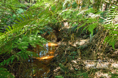
Photograph, Fred Mitchell, Splitters Creek (?) track, Silvan, 16 April 2008, 16/04/2008
... Splitters Creek (?) track, Silvan, 16 April 2008......Silvan...track, Silvan, 16 April 2008 Photograph Fred Mitchell ...Digital copy of colour photographfred mitchell collection, 2008, silvan -
 Eltham District Historical Society Inc
Photograph, Fred Mitchell, Splitters Creek (?) track, Silvan, 16 April 2008, 16/04/2008
... Splitters Creek (?) track, Silvan, 16 April 2008......silvan...track, Silvan, 16 April 2008 Photograph Fred Mitchell ...Digital copy of colour photographfred mitchell collection, 2008, silvan -
 Eltham District Historical Society Inc
Negative - Photograph, Silvan Gully area, Upper Diamond Creek, c.1911
... Silvan Gully area, Upper Diamond Creek...Silvan Gully area showing the cleared line for railway construction. ...Eltham District Historical Society Inc 728 Main Rd Eltham melbourne Silvan Gully area showing the cleared line for railway construction. ...Silvan Gully area showing the cleared line for railway construction. The railway was extended from Eltham to Hurstbridge in 1912.Roll of 35mm colour negative film, 4 stripsKodak Safety 5035upper diamond creek, silvan gully, wattle glen, railway construction -
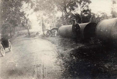 Mt Dandenong & District Historical Society Inc.
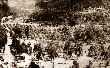
Photograph, At Site of Silvan Dam Pipes c1924, c1924
... At Site of Silvan Dam Pipes c1924....Man posed for photograph beside large water pipes destined for Silvan Dam. Car is parked at side of road....Part of a car is visible to the left. At Site of Silvan Dam Pipes c1924. Photograph Photograph ...Man posed for photograph beside large water pipes destined for Silvan Dam. Car is parked at side of road.Black and white photograph with well dressed man in suit and hat standing beside large water pipes beside a treed road. Part of a car is visible to the left.silvan dam, pipe -
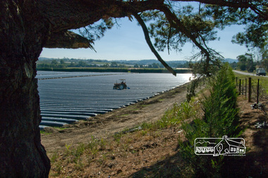
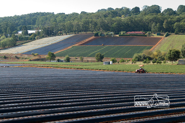 Eltham District Historical Society Inc
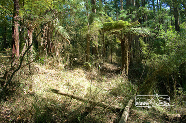
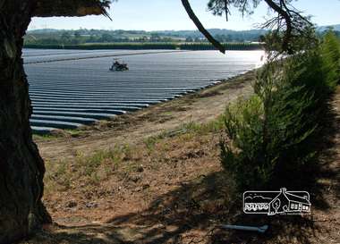
Photograph, Fred Mitchell, Strawberry farm, Silvan, 16 April 2008, 16/04/2008
... Strawberry farm, Silvan, 16 April 2008......silvan...Eltham District Historical Society Inc 728 Main Rd Eltham melbourne fred mitchell collection 2008 silvan market gardens Digital copy of colour photograph Strawberry farm, Silvan, 16 April 2008 Photograph Fred Mitchell ...Digital copy of colour photographfred mitchell collection, 2008, silvan, market gardens -
 Eltham District Historical Society Inc
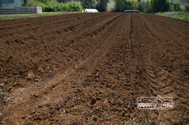
Photograph, Fred Mitchell, Market garden, Queens Road, Silvan, 16 April 2008, 16/04/2008
... Market garden, Queens Road, Silvan, 16 April 2008......silvan...Eltham District Historical Society Inc 728 Main Rd Eltham melbourne fred mitchell collection 2008 silvan market gardens Queens Road Digital copy of colour photograph Market garden, Queens Road, Silvan, 16 April 2008 Photograph Fred Mitchell ...Digital copy of colour photographfred mitchell collection, 2008, silvan, market gardens, queens road -
 Eltham District Historical Society Inc
Photograph, Fred Mitchell, On Queens Road, Silvan, April 2008, 2008
... On Queens Road, Silvan, April 2008......silvan...Eltham District Historical Society Inc 728 Main Rd Eltham melbourne fred mitchell collection 2008 silvan queens road houses Digital copy of colour photograph On Queens Road, Silvan, April 2008 Photograph Fred Mitchell ...Digital copy of colour photographfred mitchell collection, 2008, silvan, queens road, houses -
 Yarra Ranges Regional Museum
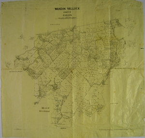
Map, H J Green, Acting Govt. Printer, Wandin Yallock, County of Evelyn (Parish Plan), c. 1910 - 1920
... Parish Plan of Wandin Yallock. Location of Silvan Reservoir marked in ink on map....Parish Plan of Wandin Yallock. Location of Silvan Reservoir marked in ink on map. ...Location of Silvan Reservoir marked in ink on map. Wandin Yallock, County of Evelyn (Parish Plan) Map H J Green, Acting Govt. ...Parish Plan of Wandin Yallock. Location of Silvan Reservoir marked in ink on map.Parish Plan of Wandin Yallock. Location of Silvan Reservoir marked in ink on map. wandin yallock, maps -
 Sunbury Family History and Heritage Society Inc.
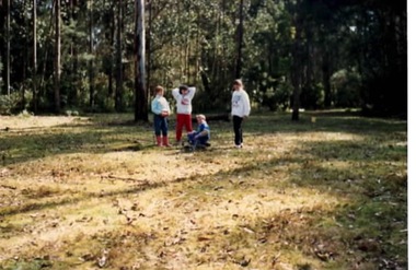
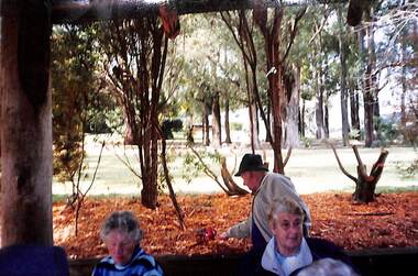
Photograph, Gundiwindi School camp, 14th - 18th August 1989
... The camp is in the Yarra Valley area on the border of North Wandin and Silvan. At the camp the children were learning bush survival skills, which were practised by the local Wurundjeri people....Silvan...The camp is in the Yarra Valley area on the border of North Wandin and Silvan. At the camp the children were learning bush survival skills, which were practised by the local Wurundjeri people. ...The photograph was taken in 1989 when students in Grades 4 and 5 from Bulla Primary School attended a school camp at Gundiwindi Camp. The camp is in the Yarra Valley area on the border of North Wandin and Silvan. At the camp the children were learning bush survival skills, which were practised by the local Wurundjeri people.The emphasis on the camp at Gundiwindi was bush survival and skills used by indigenous people.A non-digital coloured photograph of four children in a bushland setting attempting to build a camp fire in the cleared area. the forested area is behind the group.school camps, gundiwindi, bulla primary school, indigenous culture, wurundjeri people -
 Wonga Park Community Cottage History Group
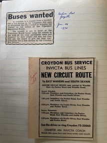
Newspaper - Newspaper cutting, Eastern Post Gazette 14/1/1970 "Buses Wanted" & Express 15/10 "New Circuit Route to East Wandin & South Silvan"
... Eastern Post Gazette 14/1/1970 "Buses Wanted" & Express 15/10 "New Circuit Route to East Wandin & South Silvan"...Wonga Park Community Cottage History Group Unit 1, 9 – 13 Old Yarra Road Wonga Park melbourne "Post" 19/3/1964 - John Usher in BP Rally, "Mail" 19/3/1964 - John Usher joins family company and resigns as a teacher but continues studying Commerce part time at Melbourne University and Unknown April 1964 - Croydon Show at Hughes Park and Croydon Bus Service will run a bus there and back Page of school exercise book with newspaper cutting/s Eastern Post Gazette 14/1/1970 "Buses Wanted" & Express 15/10 "New Circuit Route to East Wandin & South Silvan" Newspaper Newspaper cutting ..."Post" 19/3/1964 - John Usher in BP Rally, "Mail" 19/3/1964 - John Usher joins family company and resigns as a teacher but continues studying Commerce part time at Melbourne University and Unknown April 1964 - Croydon Show at Hughes Park and Croydon Bus Service will run a bus there and backPage of school exercise book with newspaper cutting/s -
 Mt Dandenong & District Historical Society Inc.
Photograph
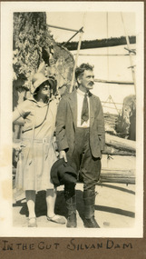
... The photograph shows Ivy May Child standing with her father Ted Child at the Silvan Dam worksite. The construction of Silvan Dam took place between 1926 and the 1932 opening. ...Written below photo in album: IN THE CUT SILVAN DAM...Farndons Community Hall 42 Falls Road Mt Dandenong yarra-valley-and-the-dandenong-ranges The photograph shows Ivy May Child standing with her father Ted Child at the Silvan Dam worksite. The construction of Silvan Dam took place between 1926 and the 1932 opening. ...The photograph shows Ivy May Child standing with her father Ted Child at the Silvan Dam worksite. The construction of Silvan Dam took place between 1926 and the 1932 opening. Ivy May Child (1910 – 1989) was the daughter of Arthur Edward (Ted) Child (1878 – 1964) and Ethel May Madden (1888 – 1970). Ted Child was the son of Matthew Francis Child (1839 – 1933) and Martha Jeeves (1857 – 1926). He was the grandson of one of the early pioneers Francis Child. Ivy grew up on the family property on Childs Road and took many photographs. Most of these are glued into her photo album. The album covered the years from c1927 – 1932. Ivy married Henry William Burgess (1906 – 1968) in 1944. The photographs remain in their original state in the album with individual copies made. Black and white photograph showing a man and woman standing in a cutting. The woman is in a dress and wearing a shady hat. The man is wearing a jacket and jodhpur like trousers with leather gaiters. He is holding a wide brimmed hat.Written below photo in album: IN THE CUT SILVAN DAMivy child, ted child, silvan dam -
 Victorian Railway History Library
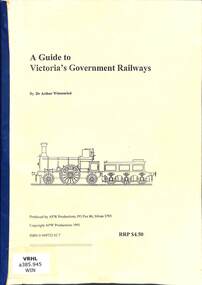
Book, Winzenreid, Arthur, A Guide to Victoria's Government Railways, 1995
... Silvan, Victoria, Australia ...A research report on the Victoria Government Railways.ill, p.25.non-fictionA research report on the Victoria Government Railways.victorian railways - history, research report - victorian railways - history -
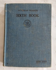 Mont De Lancey
Book, Education Department of Victoria, The Victorian Readers Sixth Book, 1950's
... 'Norman. Chapman. Silvan. Grade V1'...'Norman. Chapman. Silvan. Grade V1' A dark blue fabric covered hardcover with the title Victorian Reader Sixth Book, printed in black lettering at the top of the front cover. ...The Victorian Readers were a series of school readers (eight in number) produced between 1928 and 1930 for school children in Victoria and used (with revisions) until the 1950s. This is a first edition of The Victorian Readers Sixth Book published by the Education Department of Victoria for use in Grade Six in Primary Schools.A dark blue fabric covered hardcover with the title Victorian Reader Sixth Book, printed in black lettering at the top of the front cover. Underneath is a black circle with Education Department Victoria surrounding a symbol. Second Edition is printed at the lower right on the front cover. All children in Victorian Primary Schools were given these readers to supplement their reading at home. The cover is coming away from the spine. There is a Contents, Acknowledgements and Notes and Comments at the back for teacher and student use.There are short stories, poems and black and white illustrations. Lance Sebire is written in ink on the front cover. 244 Pp.non-fictionThe Victorian Readers were a series of school readers (eight in number) produced between 1928 and 1930 for school children in Victoria and used (with revisions) until the 1950s. This is a first edition of The Victorian Readers Sixth Book published by the Education Department of Victoria for use in Grade Six in Primary Schools.school reader, textbooks, schools, victorian education department -
 Ringwood and District Historical Society
Booklet - Geological Survey Report, Explanatory Notes on Ringwood, Victoria by A.H.M. Vandenberg, 1971
... Geological description of the eastern and southeastern suburbs of Melbourne, Dandenong Ranges, Harkaway Hills and the Silvan and Macclesfield districts....Ringwood and District Historical Society 125A Warrandyte Road Ringwood North melbourne Geological description of the eastern and southeastern suburbs of Melbourne, Dandenong Ranges, Harkaway Hills and the Silvan and Macclesfield districts. Explanatory Notes on Ringwood, Victoria by A.H.M. ...Geological description of the eastern and southeastern suburbs of Melbourne, Dandenong Ranges, Harkaway Hills and the Silvan and Macclesfield districts. -
 Sunshine and District Historical Society Incorporated
Photograph - Sunshine & District Historical Society's Trip To To Silvan Reservoir Mont De Lancey Wandin 2003 Photographs, 2nd May 2003
... Collection of colour photograph of the Sunshine & District Historical Society's Trip To To Silvan Reservoir Mont De Lancey Wandin...Sunshine & District Historical Society Silvan Reservoi r Mont De Lancey Wandin Collection of colour photograph of the Sunshine & District Historical Society's Trip To To Silvan Reservoir Mont De Lancey Wandin Photograph Sunshine & District Historical Society's Trip To To Silvan Reservoir Mont De Lancey Wandin 2003 Photographs ...sunshine & district historical society, silvan reservoi, r mont de lancey, wandin -
 Mt Dandenong & District Historical Society Inc.
Photograph, Child Family Property Kalorama Valley c1900, c1900
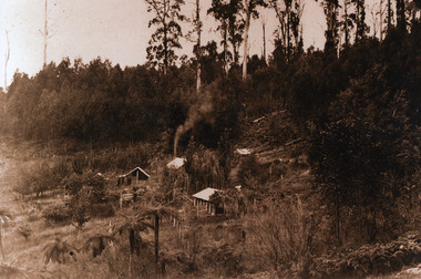
... Child property went almost to Silvan. Harry Child had the sawmill....Child property went almost to Silvan. Harry Child had the sawmill. Child Family Property Kalorama Valley c1900 Photograph Photograph ...Landscape showing land clearance against uncleared bush. Child property went almost to Silvan. Harry Child had the sawmill.child, harry child, kalorama valley -
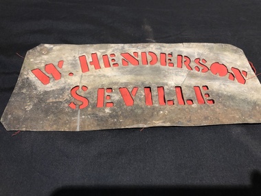 Mont De Lancey
Stencils
... Henderson Seville 2. Chapman Silvan 3. A J C H.B. 4. VPC MAC ...Henderson Seville 2. Chapman Silvan 3. A J C H.B. 4. VPC MAC 4 Metal Stencils. ...Used for fruit packing labelling.4 Metal Stencils.1. W. Henderson Seville 2. Chapman Silvan 3. A J C H.B. 4. VPC MAC stencils -
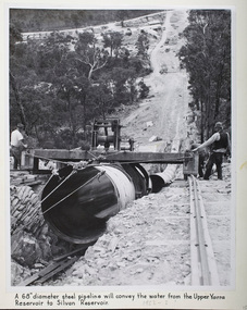 Melbourne Water
Photograph - Steel Pipeline, 1952
... The Upper Yarra Reservoir supplies the Silvan Reservoir, which distributes water throughout the Melbourne metropolitan area. ...Melbourne Water 990 La Trobe Street Docklands melbourne The Upper Yarra Reservoir supplies the Silvan Reservoir, which distributes water throughout the Melbourne metropolitan area. ...The Upper Yarra Reservoir supplies the Silvan Reservoir, which distributes water throughout the Melbourne metropolitan area. The dam was completed in 1957 and is a rolled earthfill and rockfill embankment. This photograph shows a 68" diameter steel pipeline that was to convey the water from the Upper Yarra Reservoir to the Silvan Reservoir.This photograph is significant as it provides a detailed insight into the Boards activity and construction of one of Melbourne's most important water supply systems. Furthermore, it is of historical importance to the history of Melbourne while it is representative of shaping Melbourne's environments, transforming and managing land and natural resources, and providing urban infrastructure and services. The photograph itself is aesthetically pleasing, through its depth of field and use of shape with an interesting composition. Black and white photographmmbw, melbourne metropolitan board of works, melbourne water, upper yarra reservoir, silvan reservoir, water, waterway, dam