Showing 320 items matching "silver creek"
-
 Wodonga & District Historical Society Inc
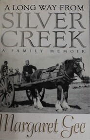
Book - A Long Way from Silver Creek: A Family Memoir, Margaret Gee, 2000
... A Long Way from Silver Creek: A Family Memoir...A Long Way from Silver Creek: A Family Memoir...A Long Way from Silver Creek: A Family Memoir Book A Long Way from Silver Creek: A Family Memoir Margaret Gee ...This book tells the story of Margaret Gee's family, spanning three generations living on the land in picturesque North Eastern Victoria, near Beechworth-Kelly country and steeped in the history of the gold rush and early pioneers. It is the story of her indomitable father, who grew up at Silver Creek, then joined the Australian Navy, became a prisoner of war on the Burma Railway after surviving the sinking of HMAS Perth, of his wife and family.non-fictionThis book tells the story of Margaret Gee's family, spanning three generations living on the land in picturesque North Eastern Victoria, near Beechworth-Kelly country and steeped in the history of the gold rush and early pioneers. It is the story of her indomitable father, who grew up at Silver Creek, then joined the Australian Navy, became a prisoner of war on the Burma Railway after surviving the sinking of HMAS Perth, of his wife and family.gee family, beechworth, rural families, country life -- victoria -
 Narre Warren and District Family History Group
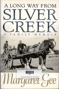
Book, Margaret Gee, A long way from Silver Creek, 2000
... A long way from Silver Creek......Silver Creek...Narre Warren and District Family History Group 110 High Street Berwick melbourne Margaret Gee Silver Creek Beechworth Memoir of Margaret Gee's family spanning three generations in North Eastern Victoria 351 p.; 23 cm A long way from Silver Creek Book Margaret Gee ...Memoir of Margaret Gee's family spanning three generations in North Eastern Victoria351 p.; 23 cmnon-fictionMemoir of Margaret Gee's family spanning three generations in North Eastern Victoriamargaret gee, silver creek, beechworth -
 Federation University Historical Collection
Booklet, E.J. Dunn, The Back Creek Silver-Lead Mine, near Buchan, Eastern Gippsland, 1905, 1905
... The Back Creek Silver-Lead Mine, near Buchan, Eastern Gippsland, 1905...gippsland buchan dickson's caves basin creek caves murrinfal river wilon's caves buchan limestone mt tara goldfield taedato creek gold workings dominion copper mine queen roeed micawbet mne surprise mine good hope mine Sixteen page booklet. The Back Creek Silver-Lead Mine, near Buchan, Eastern Gippsland, 1905 Booklet E.J. ...Sixteen page booklet.gippsland, buchan, dickson's caves, basin creek caves, murrinfal river, wilon's caves, buchan limestone, mt tara goldfield, taedato creek gold workings, dominion copper mine, queen roeed, micawbet mne, surprise mine, good hope mine -
 Greensborough Historical Society
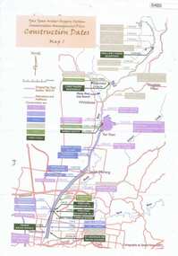
Maps, Yan Yean Water Supply System Conservation Management Plan: Construction dates Map 1, 2007_
... Plan of Yan Yean Water Supply System, showing natural and constructed features from 1850s to 1930s from Silver Creek Weirs to Eastern Freeway....Greensborough Historical Society 34A Glenauburn Road Lower Plenty Lower Plenty melbourne Plan of Yan Yean Water Supply System, showing natural and constructed features from 1850s to 1930s from Silver Creek Weirs to Eastern Freeway. water supply yan yean reservoir plenty river Printed in colour one side. 3 copies Yan Yean Water Supply System Conservation Management Plan: Construction dates Map 1 Maps Spatial Vision ...Plan of Yan Yean Water Supply System, showing natural and constructed features from 1850s to 1930s from Silver Creek Weirs to Eastern Freeway.Printed in colour one side. 3 copieswater supply, yan yean reservoir, plenty river -
 The Beechworth Burke Museum
Audio - Oral History, Jennifer Williams, Mrs Grace Irvine, 20th April 2000
... Mrs Grace Irvine was born in 1907 as one of eight children to the Shennan family in Silver Creek, a town three kilometres east of Beechworth that was considered a part of the town. ...The Beechworth Burke Museum Loch Street Beechworth high-country Mrs Grace Irvine was born in 1907 as one of eight children to the Shennan family in Silver Creek, a town three kilometres east of Beechworth that was considered a part of the town. ...Mrs Grace Irvine was born in 1907 as one of eight children to the Shennan family in Silver Creek, a town three kilometres east of Beechworth that was considered a part of the town. Her father was a 'wood-carter', contracted to deliver wood to the mining dredges at Silver Creek and the Mayday Hills asylum. Wife to Dick, and mother to four children, Mrs Irvine spent her life in Beechworth, recalling many transformations in its history and living through wars and the Depression. This oral history recording was part of a project conducted by Jennifer Williams in the year 2000 to capture the everyday life and struggles in Beechworth during the twentieth century. This project involved recording seventy oral histories on cassette tapes of local Beechworth residents which were then published in a book titled: Listen to what they say: voices of twentieth century Beechworth. These cassette tapes were digitised in July 2021 with funds made available by the Friends of the Burke.The oral history record of Mrs Grace Irvine is a rare and representative insight into life in Beechworth from the turn of the 20th century to the 21st century, specifically in the descriptions of the everyday, commerce, business, family, and leisure activities for residents of the town throughout war-time and the Depression. Mrs Irvine's recollections have a social value to the Irvine family who have a long enduring history with Beechworth, and so also provide significance to the social and cultural history of the town. This oral history account is socially and historically significant as it is a part of a broader collection of interviews conducted by Jennifer Williams which were published in the book 'Listen to what they say: voices of twentieth-century Beechworth.' While the township of Beechworth is known for its history as a gold rush town, these accounts provide a unique insight into the day-to-day life of the town's residents during the 20th century, many of which will have now been lost if they had not been preserved.This is a digital copy of a recording that was originally captured on a cassette tape. The cassette tape is black with a horizontal white strip and is currently stored in a clear flat plastic rectangular container. It holds up 40 minutes of recordings on each side.Mrs Grace Irvine /listen to what they say, beechworth, oral history, burke museum, irvine, grace irvine -
 The Beechworth Burke Museum
Photograph, est. 1860-1875
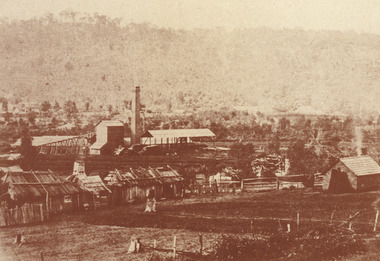
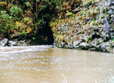
... This extensive complex, of which nothing remains, was situated between Silver Creek and the present Lake Sambell area. ...This extensive complex, of which nothing remains, was situated between Silver Creek and the present Lake Sambell area. ...In 1875, the Rocky Mountain Extended Gold Sluicing Company Ltd was created, utilising the previous Rocky Mountain claim for the area near Lake Sambell. The company employed A.L Martin to survey an area for a tunnel underneath Beechworth and Johnson Stephens to dig it. The tunnel was built at a rate of 40 feet a month and eventually measured 800 metres. The tunnel was a true accomplishment both in the present and during the 19th century. It was considered to be a marvelous engineering feat. Beechworth is renowned for its hydraulic sluice method of mining. This involved soil being exposed to torrents of water from high-pressure hoses. From 1876 until its closure in 1921, the mine produced an astounding 47,926 ozs of gold. Companies like this were the source of income for many Chinese gold-diggers who sought to make their fortune on the goldfields of Beechworth. During the height of the rush, the town had around 7,000 Chinese inhabitants living on the outskirts of town as they were not permitted to live within Beechworth itself.The search for gold is ingrained into the history of Victoria and therefore, images like this one which portrays an open-cut sluicing site can reveal important information for society and technology for the date when the photograph was taken. This image is of important historical significance for its ability to convey information about sluicing and the methods used to find gold in 1910. It also shows a location where sluicing was undertaken which provides insight into the impact of sluicing on the environment at a time when it was done. This image of the Rocky Mountain mine is historically significant as the mining complex is now non-existent, with the only remains being the tunnel built in 1880 by the company, which was considered one of the greatest engineering feats of the time. The image also provides a first-hand look into the social and cultural networks at play during the 19th century with racial segregation of the Chinese at the 'Chinese Camp', as well as an insight into Beechworth's origins during the Gold Rush.A sepia rectangular photograph printed on matte photographic paper as a postcardReverse: Historic Beechworth / 7792.1 / ROCKY MOUNTAIN MINE / Viewed from the “Chinese Camp”, shown partly in the foreground, we see the central plant of the famous Rocky Mountain Mining Company. This extensive complex, of which nothing remains, was situated between Silver Creek and the present Lake Sambell area. The company was responsible for a tunnel cut through solid bedrock underneath the town of Beechworth and surfacing near the keystone bridge on the Wangaratta side. Completed in 1880 it was declared to be one of the greatest engineering feats in Australia. The tunnel is still basically intact today. / Series by Wooragee Graphics: Historic Beechworth. / COPYRIGHT BURKE MUSEUM / No.72 beechworth, rocky mountain mine, sluicing, gold rush, mining, gold -
 Halls Gap & Grampians Historical Society
Photograph - B/W, C 1890
... Charles was ther son of William D'Alton if "Silver Springs" on Dairy Creek, and Fred (Alfred) was the son of John D'Alton, Stawell Borough engineer. ...Charles was ther son of William D'Alton if "Silver Springs" on Dairy Creek, and Fred (Alfred) was the son of John D'Alton, Stawell Borough engineer. ...The man with the horse is Charles D'Alton, his cousin Alfred is beckoning him to come on. Charles was ther son of William D'Alton if "Silver Springs" on Dairy Creek, and Fred (Alfred) was the son of John D'Alton, Stawell Borough engineer. Fred and Charles were responsible for finding many of today's walking track routes through the Wonderland Range and in the Mt. Rosea area. The second copy is a transparency (slide) , no. 182 in the slide box.Photo shows man, left side corner with pack horse andother man middle ground with arm raised"Charles D'Alton beckoning to his cousin Alfred to come on" finding the best routegilbert rogers, vehicle track, people, d'alton -
 Kiewa Valley Historical Society
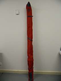
Ski Bag - snow
... Local skier, Doug McConville skied at Falls Creek and used the skis in the 1976 Winter Olympics. doug mc conville. downhill skis. 1976 winter olympics. snow. Blue leather "D". Custom made red vinyl lined fabric bag with 110 cm zipper with silver stud. ...Used by Doug Mc Conville in the 1976 Winter Olympics. He crashed in his event.Local skier, Doug McConville skied at Falls Creek and used the skis in the 1976 Winter Olympics.Custom made red vinyl lined fabric bag with 110 cm zipper with silver stud. Blue leather reinforcing patches top and bottom. Blue leather "D" initial patch and bottomless side pocket with blue leather binding.Blue leather "D".doug mc conville. downhill skis. 1976 winter olympics. snow. -
 Kiewa Valley Historical Society
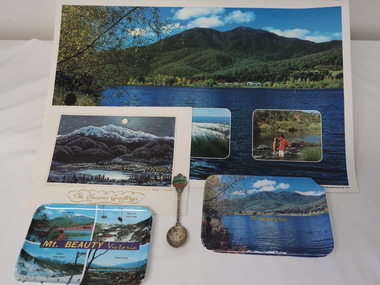
Souvenirs - Mt Beauty
... Plastic coloured trays x3 - Mt Beauty Vic. x2 and Mt Beauty Victoria (4 photos including Mt Bogong, Falls Creek x2, Kiewa Valley.) 4.Silver plated spoon "Mt Beauty Vic." ...Silver plated" 1. Coloured shiny poster with photos of mountains, river and fishing backed on to orange & white pattern. 2. Christmas card "Mt Bogong and Mr Beauty Township" on the back in gold Markdon Prints, Porpunkah ..."" 3. Plastic coloured trays x3 - Mt Beauty Vic. x2 and Mt Beauty Victoria (4 photos including Mt Bogong, Falls Creek ...Originally an SEC town built for workers on the Kiewa Hydro Electric Scheme. It became a tourist centre from the 1960s.Examples made to increase tourism with historical photos, historical items no longer used or sought after. Items such as these are a different way of advertising to on-line methods used today1. Coloured shiny poster with photos of mountains, river and fishing backed on to orange & white pattern. 2. Christmas card "Mt Bogong and Mr Beauty Township" on the back in gold Markdon Prints, Porpunkah ..."" 3. Plastic coloured trays x3 - Mt Beauty Vic. x2 and Mt Beauty Victoria (4 photos including Mt Bogong, Falls Creek x2, Kiewa Valley.) 4.Silver plated spoon "Mt Beauty Vic." 1. Printed bottom left hand corner "Mount Beauty, Victoria" 2.Centre front "The Seasons Greetings" with title written under painting also "From the painting by Marcus L. O'Donnell" 3. On the back of the tray with 4 photos - embossed "A Starlite Product ..." 4. Embossed on back of handle "Stuart / Silver plated"mt beauty tourism -
 Emerald Museum & Nobelius Heritage Park
B/W Photograph, December 1904
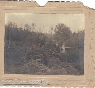
... Front bottom left: silver embossed "With the Compliments of the Season" Rear: Handwritten "Mrs Airey & Miss Doolan on Bridge over Creek From ?...From it we can make out some details of their dress and the physical surroundings of the time. airey doolan creek country club 1904 Front bottom left: silver embossed "With the Compliments of the Season" Rear: Handwritten "Mrs Airey & Miss Doolan on Bridge over Creek From ? ...The card was probably sent as a Christmas gift to an unknown recipient by "H & GB", presumably a married couple. The two women in the photo might be known to sender and receiver, or might even be the receivers. The scene is suspected to be in the grounds of the Country Club at Emerald, Victoria.As the card is clearly dated, and the figures clearly named, it is a record of people resident in Emerald. From it we can make out some details of their dress and the physical surroundings of the time.B/W photograph mounted on embossed cardboard with crimped edges. It depicts two women standing on a small bridge over a creek in dense vegetation. There are trees in the background and ferns in the foreground. Front bottom left: silver embossed "With the Compliments of the Season" Rear: Handwritten "Mrs Airey & Miss Doolan on Bridge over Creek From ?H & ?GB 18?/12/1904" At bottom: "May be Country Club"airey, doolan, creek, country club, 1904 -
 Orbost & District Historical Society
cutlery box, Jensen, Peter, Early 20th century
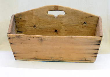
... Peter Jensen came to Martin's Creek (35 miles north of Orbost) in 1890 having been told that Martin's Creek would be on the railway line. He was a cooper who made the casks from silver wattles. ...Peter Jensen came to Martin's Creek (35 miles north of Orbost) in 1890 having been told that Martin's Creek would be on the railway line. He was a cooper who made the casks from silver wattles. ...Made for Danebo Guest House at Martin's Creek. Peter Jensen came to Martin's Creek (35 miles north of Orbost) in 1890 having been told that Martin's Creek would be on the railway line. He was a cooper who made the casks from silver wattles. He cleared the area for farming and then built an accommodation house, Danebo., which was well used by travellers to Bonang and Bendoc. Gippsland was a relatively less developed part of Victoria in the nineteenth century. Danebo Hotel, Martin’s Creek, would have been an important stopping point for travellers to Bonang and Bendoc. The hotel is no longer standing.A open rectangular shaped wooden cutlery box - probably hand-made.. It has a carrying handle cut into the divider.jensen-peter martin's-creek danebo cutlery-box container -
 Orbost & District Historical Society
Certificate - share, 30/10/1940
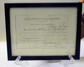
... Gold, copper and silver were the target minerals.The crusher from the Boulder Mine is now at the Slab Hut in Orbost. The first Gippsland Boulder Co.,was at Boulder Creek – 13 miles north of Club Terrace, within 2 miles of Errinundra River. ...Gold, copper and silver were the target minerals.The crusher from the Boulder Mine is now at the Slab Hut in Orbost. The first Gippsland Boulder Co.,was at Boulder Creek – 13 miles north of Club Terrace, within 2 miles of Errinundra River. ...Share certificate issued by New Gippsland Boulder Mine - operating at Errinundra and receipt for Herbert, Eric W. Receipt is for amount of four pounds - signed by Bird, W. Prospectus was printed in 1934 at office of Snowy River Mail - 4 page booklet. Gold, copper and silver were the target minerals.The crusher from the Boulder Mine is now at the Slab Hut in Orbost. The first Gippsland Boulder Co.,was at Boulder Creek – 13 miles north of Club Terrace, within 2 miles of Errinundra River. The company registered in January 1898 and commenced crushing in September with a 10-head battery. In the first nine months’ yields totalled 1,418 oz from 972 tons.There was a tramway between the mine workings and the battery.The crusher from the Boulder Mine is now adjacent to the Slab Hut in Orbost. This document is a reference for gold mining and exploration in the Far East Gippsland area. The Herbert family has resided in Orbost since the late 19th century.Copy of New Gippsland Boulder Mine share certificate and receipt 1940. Framed in small black wooden frame.certificate-share-new-gippsland-boulder-mine mineralogy mining boulder-creek -
 Orbost & District Historical Society
plane, early 20th century
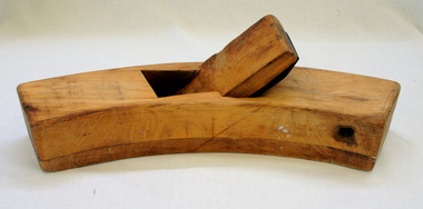
... This roughing plane was used by Peter Jensen who came to Martin's Creek (35 miles north of Orbost) in 1890 having been told that Martin's Creek would be on the railway line. He was a cooper who made the casks from silver wattles. ...Orbost & District Historical Society Ruskin Street Orbost gippsland This roughing plane was used by Peter Jensen who came to Martin's Creek (35 miles north of Orbost) in 1890 having been told that Martin's Creek would be on the railway line. He was a cooper who made the casks from silver wattles. ...This roughing plane was used by Peter Jensen who came to Martin's Creek (35 miles north of Orbost) in 1890 having been told that Martin's Creek would be on the railway line. He was a cooper who made the casks from silver wattles. He cleared the area for farming and then built an accommodation house, Danebo.Ths item is an example of a woodworking tool used in the late 19th to early 20th century.Large smooth wooden roughing plane. It is curved and has a large metal blade. roughing-plane tool jensen-peter -
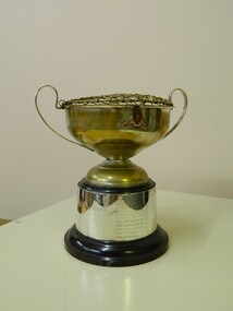 Ballarat Clarendon College
Trophy
... It is currently awarded to the leader/s of the Concert Band. p-c-law m-j-almond john-dawson m-r-j-moreton r-p-jenkins matthew-dawson laura-dunlop g sadler s-mitchell jonathon-gunthorpe k-campbell-jones matthew-haymes barry-cockcroft cindy-louey damien-noonan jacqueline-sewell meaghan-keith dale-heard rebecca-smithers elissa-howell jonathan-stewart emma-coltman anthony-bull michael-goeman jessica-avery jeremy-russell philip-smith georgia-roberts sarah-alexander mikhaila-clements matthew-creek sarah-clark penelope-jackson matthew-day jessica-mciver alistair-macdonald megan-tweedie lauren-james simone-trengove georgia-harman samuel-mcdonald christina-simpson todd-jacobsson darcy-gray dylan-young jack-walker Ballarat College crest fixed to bowl of cup Inscribed on name plate: Ballarat College / best bandsman / Presented By / J M Stayt / 12th November / 1971 Medium sized silver cup on melamine base, double handles and flower netting across bowl opening; silver name plate around base. ...Trophy presented annually to the best bandsman 1971 - Ballarat College established a formal Music School in 1969 and an amazing upsurge of interest in musical activities followed. This prize was the gift of J M Stayt, teacher at the school 1964 - 1993. It is currently awarded to the leader/s of the Concert Band. Medium sized silver cup on melamine base, double handles and flower netting across bowl opening; silver name plate around base. Ballarat College crest fixed to bowl of cup Inscribed on name plate: Ballarat College / best bandsman / Presented By / J M Stayt / 12th November / 1971 p-c-law, m-j-almond, john-dawson, m-r-j-moreton, r-p-jenkins, matthew-dawson, laura-dunlop, g sadler, s-mitchell, jonathon-gunthorpe, k-campbell-jones, matthew-haymes, barry-cockcroft, cindy-louey, damien-noonan, jacqueline-sewell, meaghan-keith, dale-heard, rebecca-smithers, elissa-howell, jonathan-stewart, emma-coltman, anthony-bull, michael-goeman, jessica-avery, jeremy-russell, philip-smith, georgia-roberts, sarah-alexander, mikhaila-clements, matthew-creek, sarah-clark, penelope-jackson, matthew-day, jessica-mciver, alistair-macdonald, megan-tweedie, lauren-james, simone-trengove, georgia-harman, samuel-mcdonald, christina-simpson, todd-jacobsson, darcy-gray, dylan-young, jack-walker -
 Eltham District Historical Society Inc
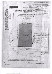
Document - Photocopy, Survey Fleld Notes of Part of Crown Portion 13, Section 4 at Eltham, Parish of Nillumbik, County of Evelyn, 1902-1903
... Creek)...Diamond Street...Eltham...Eltham Railway Station...henry street...Main Road...silver...Eltham District Historical Society Inc 728 Main Rd Eltham melbourne Main Road, Henry Street to Diamond Street; Silver Street to Bible Street Application No. 033777 1902 1903 Arthur Street Bible Street Bird street Diamond Creek (Creek) Diamond Street Eltham Eltham Railway Station henry street Main Road silver street Survey Plan Vine street Application 33777 Map A4 printouts, 7 pages Survey Fleld Notes of Part of Crown Portion 13, Section 4 at Eltham, Parish of Nillumbik, County of Evelyn Document Photocopy ...Main Road, Henry Street to Diamond Street; Silver Street to Bible Street Application No. 0337771902, 1903, arthur street, bible street, bird street, diamond creek (creek), diamond street, eltham, eltham railway station, henry street, main road, silver street, survey plan, vine street, application 33777, map -
 Greensborough Historical Society
Photograph - Digital image, Eddie Smith at Sutherland Homes, 1956c
... Black and white photograph or Eddie (Edmond) Smith at Sutherland Homes in Diamond Creek. Eddie's story can be read in "The Silver Poplar"....Greensborough Historical Society 34A Glenauburn Road Lower Plenty Lower Plenty melbourne Black and white photograph or Eddie (Edmond) Smith at Sutherland Homes in Diamond Creek. Eddie's story can be read in "The Silver Poplar". edmond smith sutherland homes for children Black and white digital photograph Eddie Smith at Sutherland Homes Photograph - Digital image ...Black and white photograph or Eddie (Edmond) Smith at Sutherland Homes in Diamond Creek. Eddie's story can be read in "The Silver Poplar".Black and white digital photographedmond smith, sutherland homes for children -
 Eltham District Historical Society Inc
Album - Photograph Album, J.A. McDonald, Bridge and Road Reconstruction Works, Shire of Eltham, 1952-1962
... silver street...Sir Dallas Brooks...Smedley property...St Andrews...Steels Creek... Street Bridge silver street Sir Dallas Brooks Smedley property St Andrews Steels Creek Susan Street tarrawarra Tony Carberry Uniting Church Upper Yarra Dam Upper Yarra Reservoir W.E. ...J.A. McDonald produced this record in the course of his responsibilities as Shire Engineer for Eltham Shire Council.Record of various Shire of Eltham infrastructure works undertaken during the period of 1952-1962 involving bridge and road reconstruction projects, sometimes with Eltham Shire Council Project Reference numbers quoted. It was during this period that a number of significant improvements were made to roads and new bridges constructed within the shire that remain in place as of present day (2022). In many situations, the photos provide a tangible visible record of infrastructure that existed throughout the early days of the Shire. The album was put together by or under the direction of the Shire Engineer, J.A. McDonald.a. gillies, alistair knox park, benchmark studies, bend of islands, blease road, box hill state school, box hill teachers college, box hill tip, bridge construction, bridge street bridge, bridge, brisbane street, brougham steet, bulldozer, cecil street, charis pelling, cherry tree road, city of preston, cr. a. brinkkotter, cr. charis pelling, cranes, cromwell street, diamond creek (creek), diamond street, dixons creek bridge, dixon's creek road, drott, eltham leisure centre, eltham north, eltham police station, eltham, eltham-yarra glen road, f. wood, fitzsimons lane bridge, flat rock road, flood damage, floods, floodwater, footpaths and gutters, ford service garage, g. blair, garden hill, glen park bridge, glenauburn road, grand hotel, haldane road, healesville, healesville-yarra glen road, heidelberg-kinglake road, henley road bridge, henley road, hill property, hurstbridge water scheme, hurstbridge, hurstbridge-arthurs creek road, infrastructure, j. jolly, kangaroo ground, kangaroo ground-queenstown road, kangaroo ground-st andrews road, lilydale shire office, long gully bridge, long gully creek, long gully road, long gully, lower plenty bridge, lower plenty footbridge, lower plenty oval, lower plenty road, lower plenty, main road, methodist church, montmorency, mount pleasant road, new holland, old healesville road, opening ceremony, oxley bridge, para road, paul creek bridge, paul creek road, paul krafeznk, pinnacle lane, plaques, plenty river trail, plenty river, presbyterian church, prof donald thomson, pryor street, railway crossing, railway parade, rattray road, reconstruction works, reichelt avenue, research (vic.), research oval, road construction, rymers corner, shire of eltham, shire of whittlesea, silvan road bridge, silver street bridge, silver street, sir dallas brooks, smedley property, st andrews, steels creek, susan street, tarrawarra, tony carberry, uniting church, upper yarra dam, upper yarra reservoir, w.e. wolf, waterfall property, watsons creek, wattletree road bridge, wattletree road, wattletree road bridge, worlingworth, yarra glen, york street, yow yow creek -
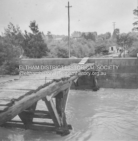
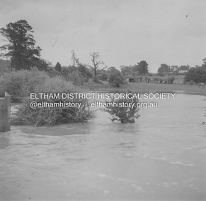 Eltham District Historical Society Inc
Album - Photograph, J.A. McDonald, Eltham-Greensborough Road, 18 Oct. 1956
... Creek)...floods...Floodwater...Hill property...Silver...Infrastructure Road construction shire of eltham bridge construction Bridge Street Bridge Eltham Eltham-Greensborough Road 1956-10-18 Diamond Creek (Creek) floods Floodwater Hill property Silver Street Bridge Black and white photo print (location of negative unknown) Adhered to a page in an album of 78 foolscap pages containing a sequence of photos, adhered via glue or sticky tape, with typed or handwritten headings and captions in pencil. ...Bridge Street Bridge Flooding on Hill’s property 18th October 1956 This view is looking west north west from the Bridge Street Bridge across the present day Eltham Skatepark. The shed visibile in the distance is directly opposite Brisbane Street where it used to run into Susan Street but now turns the corner. To the right of the shes is the site for present-dayHarris Plumbing which was formerly occupied by Sibbel Builders; to the left the site now occupied by Bunnings. At the skyline to the right of centreeline is a gap in the trees where the railway line runs. The Silver Street bridge over the railway is visible. Beware!.. our rivers are rising (1956, October 19). The Argus (Melbourne, Vic. : 1848 - 1957), p. 1. Retrieved August 24, 2022, from http://nla.gov.au/nla.news-article84392304Record of various Shire of Eltham infrastructure works undertaken during the period of 1952-1962 involving bridge and road reconstruction projects, sometimes with Eltham Shire Council Project Reference numbers quoted. It was during this period that a number of significant improvements were made to roads and new bridges constructed within the shire that remain in place as of present day (2022). In many situations, the photos provide a tangible visible record of infrastructure that existed throughout the early days of the Shire. The album was put together by or under the direction of the Shire Engineer, J.A. McDonald.infrastructure, road construction, shire of eltham, bridge construction, bridge street bridge, eltham, eltham-greensborough road, 1956-10-18, diamond creek (creek), floods, floodwater, hill property, silver street bridge -
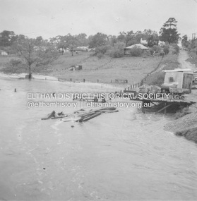
 Eltham District Historical Society Inc
Album - Photograph, J.A. McDonald, Eltham-Greensborough Road, 18 Oct. 1956
... Creek)...floods...Floodwater...Silver...Infrastructure Road construction shire of eltham bridge construction Bridge Street Bridge Eltham Eltham-Greensborough Road 1956-10-18 Diamond Creek (Creek) floods Floodwater Silver Street Bridge Black and white photo print (location of negative unknown) Adhered to a page in an album of 78 foolscap pages containing a sequence of photos, adhered via glue or sticky tape, with typed or handwritten headings and captions in pencil. ...Bridge Street Bridge Flood level on Greensborough pier 18th October 1956 View looking west across the Diamond Creek and tempoary walking access bridge towards intersection of Susan Street. The building visible on centreeline is the present-day SES facility. Beware!.. our rivers are rising (1956, October 19). The Argus (Melbourne, Vic. : 1848 - 1957), p. 1. Retrieved August 24, 2022, from http://nla.gov.au/nla.news-article84392304Record of various Shire of Eltham infrastructure works undertaken during the period of 1952-1962 involving bridge and road reconstruction projects, sometimes with Eltham Shire Council Project Reference numbers quoted. It was during this period that a number of significant improvements were made to roads and new bridges constructed within the shire that remain in place as of present day (2022). In many situations, the photos provide a tangible visible record of infrastructure that existed throughout the early days of the Shire. The album was put together by or under the direction of the Shire Engineer, J.A. McDonald.infrastructure, road construction, shire of eltham, bridge construction, bridge street bridge, eltham, eltham-greensborough road, 1956-10-18, diamond creek (creek), floods, floodwater, silver street bridge -
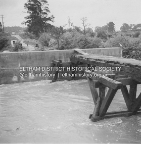
 Eltham District Historical Society Inc
Album - Photograph, J.A. McDonald, Eltham-Greensborough Road, 18 Oct. 1956
... Creek)...floods...Floodwater...Silver...Infrastructure Road construction shire of eltham bridge construction Bridge Street Bridge Eltham Eltham-Greensborough Road 1956-10-18 Diamond Creek (Creek) floods Floodwater Silver Street Bridge Alistair Knox Park Waterfall property Black and white photo print (location of negative unknown) Adhered to a page in an album of 78 foolscap pages containing a sequence of photos, adhered via glue or sticky tape, with typed or handwritten headings and captions in pencil. ...Bridge Street Bridge Flooding on Waterfall’s Estate 18th October 1956 Looking east up to Main Road over what is now present-day Alistair Knox Park Beware!.. our rivers are rising (1956, October 19). The Argus (Melbourne, Vic. : 1848 - 1957), p. 1. Retrieved August 24, 2022, from http://nla.gov.au/nla.news-article84392304Record of various Shire of Eltham infrastructure works undertaken during the period of 1952-1962 involving bridge and road reconstruction projects, sometimes with Eltham Shire Council Project Reference numbers quoted. It was during this period that a number of significant improvements were made to roads and new bridges constructed within the shire that remain in place as of present day (2022). In many situations, the photos provide a tangible visible record of infrastructure that existed throughout the early days of the Shire. The album was put together by or under the direction of the Shire Engineer, J.A. McDonald.infrastructure, road construction, shire of eltham, bridge construction, bridge street bridge, eltham, eltham-greensborough road, 1956-10-18, diamond creek (creek), floods, floodwater, silver street bridge, alistair knox park, waterfall property -
 Eltham District Historical Society Inc
Album - Photograph, J.A. McDonald, Eltham-Greensborough Road, 18 Oct. 1956
... Creek)...floods...Floodwater...Silver...Infrastructure Road construction shire of eltham bridge construction Bridge Street Bridge Eltham Eltham-Greensborough Road 1956-10-18 Diamond Creek (Creek) floods Floodwater Silver Street Bridge Black and white photo print (location of negative unknown) Adhered to a page in an album of 78 foolscap pages containing a sequence of photos, adhered via glue or sticky tape, with typed or handwritten headings and captions in pencil. ...Bridge Street Bridge Flood level on Eltham pier 18th October 1956 Looking west across the Diamond Creek to Susan Street intersection Beware!.. our rivers are rising (1956, October 19). The Argus (Melbourne, Vic. : 1848 - 1957), p. 1. Retrieved August 24, 2022, from http://nla.gov.au/nla.news-article84392304Record of various Shire of Eltham infrastructure works undertaken during the period of 1952-1962 involving bridge and road reconstruction projects, sometimes with Eltham Shire Council Project Reference numbers quoted. It was during this period that a number of significant improvements were made to roads and new bridges constructed within the shire that remain in place as of present day (2022). In many situations, the photos provide a tangible visible record of infrastructure that existed throughout the early days of the Shire. The album was put together by or under the direction of the Shire Engineer, J.A. McDonald.infrastructure, road construction, shire of eltham, bridge construction, bridge street bridge, eltham, eltham-greensborough road, 1956-10-18, diamond creek (creek), floods, floodwater, silver street bridge -
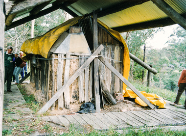 Eltham District Historical Society Inc
Photograph, Slab hut, Warrandyte, Warrandyte Mystery Tour, 29 May 1994, 29/05/1994
... Creek to the entrance of the 4th Hill Mine. Again we crept along with our torches, careful of the low roof-rock, and side shafts. At a junction in a large cavity we were able to stand, look up a long air-vent which some 'cavers' climb down, and marvel at, and experience an aspect of a miner's life. Outside we heard the same bird songs, the trills and bell-pealing, saw the same straggly eucalypts, and a silver...Creek to the entrance of the 4th Hill Mine. Again we crept along with our torches, careful of the low roof-rock, and side shafts. At a junction in a large cavity we were able to stand, look up a long air-vent which some 'cavers' climb down, and marvel at, and experience an aspect of a miner's life. Outside we heard the same bird songs, the trills and bell-pealing, saw the same straggly eucalypts, and a silver ...[article by Bettina Woodburn in EDHS Newsletter No. 97, July 1994:] THE WARRANDYTE MYSTERY TOUR MAY 29TH 1994 - Members of the Eltham Historical Society met at the Old Post Office, now converted into the Warrandyte Historical Museum, for a picnic lunch on the sunny back verandah overlooking the shimmering Yarra River. Interesting photographs and artefacts filled various rooms outlining the history of this area, and told tales of Aboriginal and more recent neighbours of the Eltham Shire. The weather was calm, cloudy mostly with only occasional sunny patches, but it wasn't cold, although the autumnal leaf colours had changed to wintry brown. "All Aboard" and we set off in the Warrandyte Community Bus (with the School Bus sign displayed at the rear) to learn about local places of "Pride and Joy” from Bruce our guide and Tom the driver. Almost directly opposite we entered Whipstick Gully to explore the first of the district's hidden treasures - the Victory, one of the largest of the six or so major mines, past the old quarry now used for abseiling practice. By torchlight we entered the rocky hillside and saw the seams of quartz the miners had followed in their search for gold. Stamping batteries, and there was one in this gully, converted discarded rock into 'road metal'. Warrandyte is proud to be the first declared Goldfield in 1851, and one of the longest surviving, into the 1920s. A pleasant drive across the Bridge and along Bradley's Lane to Norman's Reserve brought us to see another Tunnel at Pound Bend through which the Yarra was diverted to allow about three miles of river-bed to be used for prospecting for alluvial gold. Still on this side of the river we visited the Old Slab Hut in Castles Road. This remnant of miners' housing is preserved because it had been incorporated into a weatherboard house, and saved from the bulldozers - a last minute reprieve, for preservation, by the National Trust. Devastating bush fires have destroyed other old cottages built of wattle and daub, with bark roofs and stone fire-places. The Cairn commemorating the disclosure of Gold Discovery at Warrandyte on June 30th 1851 beside Anderson's Creek Road was our next point of historical interest. We drove on to South Warrandyte and circled back to above the ford on Anderson's Creek to the entrance of the 4th Hill Mine. Again we crept along with our torches, careful of the low roof-rock, and side shafts. At a junction in a large cavity we were able to stand, look up a long air-vent which some 'cavers' climb down, and marvel at, and experience an aspect of a miner's life. Outside we heard the same bird songs, the trills and bell-pealing, saw the same straggly eucalypts, and a silver leafed wattle in flower, native grasses and ferns, and the neat present day houses, often of Warrandyte stone, perhaps veneered only. The day ended pleasantly, seeing more of the Yarra from Everard Drive, and the water rushing out of the Tunnel at Pound Bend, before returning to afternoon tea or coffee at the Museum. A great day for all concerned - many thanks to the Organisers.Colour photographslab hut, warrandyte, "warrandyte miner's cottage" -
 Eltham District Historical Society Inc
Photograph, Pound Bend tunnel, Warrandyte, Warrandyte Mystery Tour, 29 May 1994, 29/05/1994
... Creek to the entrance of the 4th Hill Mine. Again we crept along with our torches, careful of the low roof-rock, and side shafts. At a junction in a large cavity we were able to stand, look up a long air-vent which some 'cavers' climb down, and marvel at, and experience an aspect of a miner's life. Outside we heard the same bird songs, the trills and bell-pealing, saw the same straggly eucalypts, and a silver...Creek to the entrance of the 4th Hill Mine. Again we crept along with our torches, careful of the low roof-rock, and side shafts. At a junction in a large cavity we were able to stand, look up a long air-vent which some 'cavers' climb down, and marvel at, and experience an aspect of a miner's life. Outside we heard the same bird songs, the trills and bell-pealing, saw the same straggly eucalypts, and a silver ...[article by Bettina Woodburn in EDHS Newsletter No. 97, July 1994:] THE WARRANDYTE MYSTERY TOUR MAY 29TH 1994 - Members of the Eltham Historical Society met at the Old Post Office, now converted into the Warrandyte Historical Museum, for a picnic lunch on the sunny back verandah overlooking the shimmering Yarra River. Interesting photographs and artefacts filled various rooms outlining the history of this area, and told tales of Aboriginal and more recent neighbours of the Eltham Shire. The weather was calm, cloudy mostly with only occasional sunny patches, but it wasn't cold, although the autumnal leaf colours had changed to wintry brown. "All Aboard" and we set off in the Warrandyte Community Bus (with the School Bus sign displayed at the rear) to learn about local places of "Pride and Joy” from Bruce our guide and Tom the driver. Almost directly opposite we entered Whipstick Gully to explore the first of the district's hidden treasures - the Victory, one of the largest of the six or so major mines, past the old quarry now used for abseiling practice. By torchlight we entered the rocky hillside and saw the seams of quartz the miners had followed in their search for gold. Stamping batteries, and there was one in this gully, converted discarded rock into 'road metal'. Warrandyte is proud to be the first declared Goldfield in 1851, and one of the longest surviving, into the 1920s. A pleasant drive across the Bridge and along Bradley's Lane to Norman's Reserve brought us to see another Tunnel at Pound Bend through which the Yarra was diverted to allow about three miles of river-bed to be used for prospecting for alluvial gold. Still on this side of the river we visited the Old Slab Hut in Castles Road. This remnant of miners' housing is preserved because it had been incorporated into a weatherboard house, and saved from the bulldozers - a last minute reprieve, for preservation, by the National Trust. Devastating bush fires have destroyed other old cottages built of wattle and daub, with bark roofs and stone fire-places. The Cairn commemorating the disclosure of Gold Discovery at Warrandyte on June 30th 1851 beside Anderson's Creek Road was our next point of historical interest. We drove on to South Warrandyte and circled back to above the ford on Anderson's Creek to the entrance of the 4th Hill Mine. Again we crept along with our torches, careful of the low roof-rock, and side shafts. At a junction in a large cavity we were able to stand, look up a long air-vent which some 'cavers' climb down, and marvel at, and experience an aspect of a miner's life. Outside we heard the same bird songs, the trills and bell-pealing, saw the same straggly eucalypts, and a silver leafed wattle in flower, native grasses and ferns, and the neat present day houses, often of Warrandyte stone, perhaps veneered only. The day ended pleasantly, seeing more of the Yarra from Everard Drive, and the water rushing out of the Tunnel at Pound Bend, before returning to afternoon tea or coffee at the Museum. A great day for all concerned - many thanks to the Organisers.Two colour photographswarrandyte, activities, pound bend -
 Bendigo Historical Society Inc.
Photograph - AILEEN AND JOHN ELLISON COLLECTION: FRAMED WEDDING PHOTOGRAPH OF BRIDE, 24 September 1949
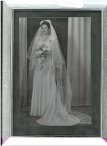
... silver frame. In black and white, this photograph shows bride Aileen Beryl Ervin of McKenzie Creek, via Horsham, in her wedding attire, for her marriage to Leslie John Ellison, of McKenzie Creek via Horsham. ...silver frame. In black and white, this photograph shows bride Aileen Beryl Ervin of McKenzie Creek, via Horsham, in her wedding attire, for her marriage to Leslie John Ellison, of McKenzie Creek via Horsham. ...Photograph. 12.5 cms x 17.5 cms, in a plain silver frame. In black and white, this photograph shows bride Aileen Beryl Ervin of McKenzie Creek, via Horsham, in her wedding attire, for her marriage to Leslie John Ellison, of McKenzie Creek via Horsham. This ceremony was officiated by Rev. Francis Fielding, on September 24th 1949, in the Horsham Methodist Church. The bride wore a beautiful gown, with a short and a long veil. Her flowers trail beautifully and she appears to be holding some horseshoes over her left arm.photograph, person, photograph of bride. -
 Bendigo Historical Society Inc.
Ephemera - Emu Creek Bush Band Collection: Ball Ticket
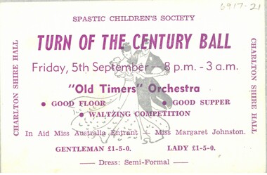
... History House 11 Mackenzie Street Bendigo goldfields Emu Creek Bush Band Spastic Children's Society Charlton A ticket from the Turn Of The Century Ball in aid of the Spastic Children's Society printed on beige card with silver trim and purple text. ...A ticket from the Turn Of The Century Ball in aid of the Spastic Children's Society printed on beige card with silver trim and purple text. Dated Friday, 5th September. Year unspecified.emu creek bush band, spastic children's society, charlton -
 Bendigo Historical Society Inc.
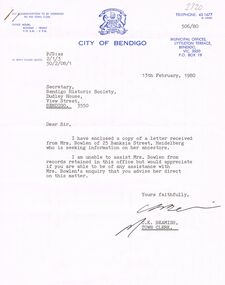
Document - BOWLEN (BOWLAN?) FAMILY: CORRESPONDENCE RE FAMILY HISTORY, 1980
... Silver Mines Hotel. Bowlen (Bowlan?) family - correspondence on enquiry from Mrs Philomena Bowlen, Heidelberg, 1980. re Family History. Seeking information - mention of Edward Timothy Bowlen (born ca. 1856 at Sandhurst or Eaglehawk). Son was John Bowlen (first white baby born at Back Creek ...Bowlen (Bowlan?) family - correspondence on enquiry from Mrs Philomena Bowlen, Heidelberg, 1980. re Family History. Seeking information - mention of Edward Timothy Bowlen (born ca. 1856 at Sandhurst or Eaglehawk). Son was John Bowlen (first white baby born at Back Creek?).person, family, bowlen family, edward timothy bowlen (bowlan), silver mines hotel. -
 Orbost & District Historical Society
black and white photograph, late 19th century - early 20th century
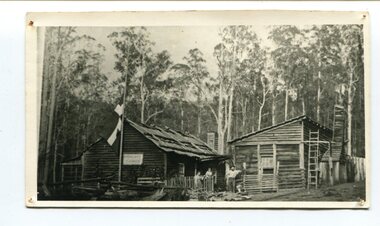
... Peter Jensen came to Martin's Creek (35 miles north of Orbost) in 1890 having been told that Martin's Creek would be on the railway line. He was a cooper who made the casks from silver wattles. ...Orbost & District Historical Society Ruskin Street Orbost gippsland Peter Jensen came to Martin's Creek (35 miles north of Orbost) in 1890 having been told that Martin's Creek would be on the railway line. He was a cooper who made the casks from silver wattles. ...Peter Jensen came to Martin's Creek (35 miles north of Orbost) in 1890 having been told that Martin's Creek would be on the railway line. He was a cooper who made the casks from silver wattles. He cleared the area for farming and then built an accommodation house, Danebo., which was well used by travellers to Bonang and Bendoc. . Gippsland was a relatively less developed part of Victoria in the nineteenth century. Danebo Hotel, Martin’s Creek, would have been an important stopping point for travellers to Bonang and Bendoc. The hotel is no longer standing A black / white photograph of a timber building - a house and another building at an angle. There are three people standing in front - a man. woman and child. On the left is a flag on a mast. In the background is bush.danebo-hotel-martins-creek jensen-peter -
 Flagstaff Hill Maritime Museum and Village
Craft - Ship Model, Peter Payne, Early 1930s to 1960s
... silver ash, black bean, Queensland maple and silky oak. It is also believed the model was a design for a clinker-built barge to be built by Peter Payne who operated a boat building works on the Mordialloc Creek, Victoria going out of business in 1973. ...silver ash, black bean, Queensland maple and silky oak. It is also believed the model was a design for a clinker-built barge to be built by Peter Payne who operated a boat building works on the Mordialloc Creek, Victoria going out of business in 1973. ...Half-hull ship models were an important step in the process of building a vessel. Shipwrights or designers would construct a half-hull scale model of a ship before the vessel was built. They used it to ensure that the dimensions would work together and that the ship look balanced. They would often mount the half hull onto a board in their workshop. The half-hull ship models were also used to show prospective buyers how the design would work and look. Given the plywood construction of the model, it is believed to have been made around the 1930s as plywood construction had started in earnest in Queensland around this time and soon became the centre of the industry because of Queensland's attractive rain forest woods used which also included red cedar, silver ash, black bean, Queensland maple and silky oak. It is also believed the model was a design for a clinker-built barge to be built by Peter Payne who operated a boat building works on the Mordialloc Creek, Victoria going out of business in 1973. Records show Peter Paynes' first craft launched in 1962 and the last in 1973 from Mordialloc Creek works. However, he was one of the most prolific builders from the 1930s and produced many more vessels than the records currently show. There is at this point no further record of the subject model or whether a full version was ever built and for whom is not known at this time.A model that demonstrates the boat-building process is believed to have been made by Peter Payne or someone who worked in his yard. P Payne was a very well-known boating personality, vessel captain and boat builder throughout most of the 20th century. Model barge half hull on wooden of plywood laminated construction. Marked "AUXILIARY BARGE 80'x16'x6' 315 TONS 4" - 1 FOOT" "P and H PAYNE?" "22/E/26" flagstaff hill, warrnambool, flagstaff-hill, flagstaff-hill-maritime-museum, maritime-museum, shipwreck-coast, flagstaff-hill-maritime-village, ship model half hull, ship half model, shipbuilding, shipwright, ship design, peter payne, boat builder victoria, clinker design, barge -
Coal Creek Community Park & Museum
Silver Dish
... Coal Creek Community Park & Museum 12 Silkstone Road Korumburra gippsland It is inscribed with a makers mark FK inside a diamond on the bottom. Small silver ...Small silver plated dish with filigree edging. The centre of the dish has a floral pattern. The dish is tarnished and the silver plate is lifting. There is a split around the edge of the filigree.It is inscribed with a makers mark FK inside a diamond on the bottom. -
Coal Creek Community Park & Museum
Instrument - Gramaphone
... Coal Creek Community Park & Museum 12 Silkstone Road Korumburra gippsland The word Windsor is inscribed on the metal plate Rectangular oak based varnished Gramaphone - Windsor Desktop type. Large cone shaped, burgundy coloured speaker (phonogram). It has silver ...Rectangular oak based varnished Gramaphone - Windsor Desktop type. Large cone shaped, burgundy coloured speaker (phonogram). It has silver brackets and a metal stylus head and round metal turntable.The word Windsor is inscribed on the metal plate