Showing 35 items matching "small footbridge"
-
 Flagstaff Hill Maritime Museum and Village
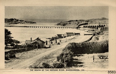
Postcard - Postcard Folder - scenes, George Rose, Rose Stereographic Company, Rose Series Picturesque Views of Warrnambool Australia [Warrnambool], 1880-1942
... ...small footbridge...Flagstaff Hill Maritime Museum and Village Great Ocean Road Shipwreck Coast Warrnambool Flagstaff Hill Flagstaff Hill Maritime Museum Flagstaff Hill Maritime Village Warramble postcard postcard folder Warrnambool Scenes Picturesque views of Warrnambool Picturesque views of Warramble Lady Bay Port of Warrnambool Breakwater Warrnambool Breakwater Viaduct Merri River footbridge Merri River suspension bridge suspension footbridge Merri River mouth Hopkins River mouth Proudfoot's Fanny Nelson Nelson's boatsheds Nelson's Boathouse boathouse Hopkins River boathouses Flett's boathouse Flett George Rose image of a rose Rose Series Rose Stereograph Co Rose Stereographic Company Lighograph Armadale Victoria Lady Bay beach beach scene Lower Light concrete footbridge 1922 footbridge Viaduct Road Rose postcard new concrete bridge 1945 1890 1922 small footbridge 1872 footbridge 1872 Merri River Estuary Stingray Bay postcards Image: [Rose with rosebud and leaves] Printed: "Rose Series / Picturesque Views of / WARRAMBOOL / AUSTRALIA" [correct spelling is WARRNAMBOOL] "PUBLISHED BY / ROSE STEREOGRAPH CO / ARMADALE. ...This postcard folder contains lithographs of photographs taken locally by Georg Rose between 1880 and 1942. He reproduced them at his company's premises, the Rose Stereographic Company at Armadale, Victoria. The postcard folder was purchased as a Warrnambool souvenir by the donor's parents around 1945 to 1950. Interestingly, the city on the cover is printed as "Warrambool", which is a location in New South Wales, but the postcards within all have the locations and text of Warrnambool. The photographs include the 'new' concrete bridge, built in 1922 to replace the original bridge, built in 1872. The boathouses belonging to Proudfoots and to Flett/Fanny Nelson are also pictured on the Hopkins River mouth. The twelve photographs included locations connected to other items in our Collection. The photographs are titled: - b. The Avenue and War Memorial. Warrnambool. Vic. c. The Blow-hole. Thunder Point. Warrnambool. Vic. d. Botanical Gardens. Warrnambool. Vic. e. Eagle Rock. Warrnambool. Vic. f. The New Concrete Bridge and Breakwater. Warrnambool. Vic. g. Liebig Street. Warrnambool. Vic. h. Looking to Thunder Point. Warrnambool. Vic. i. The Beach. Warrnambool. Vic. j. Hopkins Falls. Warrnambool. Vic. k. Shelly Beach. Warrnambool. Vic. l. The Mouth of the Hopkins River. Warrnambool. Vic. m. Panorama of Warrnambool. Vic. [Kepler Street towards Presbyterian Church on Spence St] George Rose, 1861-1942: - famous for his Late 19th and early 20th century photography. He was born in Clunes, Victoria, and was in his 20th year when he founded Rose Stereograph Company in 1880. He took the opportunity of a popular trend of the times to produce stereographs, pairs of almost duplicate photographs which appeared to be in 3D when viewed in a handheld stereo viewer. By the 1920s these lost their popularity, so he used his photographic skills to produce cards and postcards of scenes and people. The photographs in this postcard folder were taken between 1880 and 1942 by the renowned Victorian photographer George Rose. The locations match photographs and postcards in our collection that were taken at different times. A comparison between them shows the changes over time in the land and bay, the buildings and other structures, transportation and even the fashions of the times, building the story of our local history.This copy of a postcard folder has a blue-grey textured rectangular card cover with a sketch of a rose on the front along with the name of the postcard series. the location of the series' focus, the producer's details and lines for adding an address. The folded cover contains a long, concertinaed page with six titled photographs on each side, totalling twelve in all. Interestingly, the cover has the location name of "Warrambool", a place in NSW, instead of Warrnambool, the location of all of the photographs inside. The folder contains scenes from Warrnambool and nearby popular areas including Lady Bay, Port of Warrnambool, Warrnambool Breakwater, Viaduct, Merri River Footbridge, the Hopkins River Mouth, with Proudfoot’s and the Fanny Nelson/Flett boathouses. The cover has a sketch of a rose and inscriptions. The photographs for the lithographs were taken prior between 1880 and 1942 by well-known Victorian photographer, George Rose, Rose Stereograph Company of Armadale, Victoria.Image: [Rose with rosebud and leaves] Printed: "Rose Series / Picturesque Views of / WARRAMBOOL / AUSTRALIA" [correct spelling is WARRNAMBOOL] "PUBLISHED BY / ROSE STEREOGRAPH CO / ARMADALE. VIC." Printed lines (3) for an address. Printed rectangle [ ] for attaching a stamp.flagstaff hill maritime museum and village, great ocean road, shipwreck coast, warrnambool, flagstaff hill, flagstaff hill maritime museum, flagstaff hill maritime village, warramble, postcard, postcard folder, warrnambool scenes, picturesque views of warrnambool, picturesque views of warramble, lady bay, port of warrnambool, breakwater, warrnambool breakwater, viaduct, merri river footbridge, merri river suspension bridge, suspension footbridge, merri river mouth, hopkins river mouth, proudfoot's, fanny nelson, nelson's boatsheds, nelson's boathouse, boathouse, hopkins river boathouses, flett's boathouse, flett, george rose, image of a rose, rose series, rose stereograph co, rose stereographic company, lighograph, armadale victoria, lady bay beach, beach scene, lower light, concrete footbridge, 1922 footbridge, viaduct road, rose postcard, new concrete bridge, 1945, 1890, 1922, small footbridge, 1872 footbridge, 1872, merri river estuary, stingray bay, postcards -
 Flagstaff Hill Maritime Museum and Village
Postcard - Postcard Folder, scenes, George Rose, Rose Stereographic Company, Rose Series Picturesque Views of Warrnambool Australia, 1880-1942
... ...small footbridge...Flagstaff Hill Maritime Museum and Village Great Ocean Road Shipwreck Coast Warrnambool Flagstaff Hill Flagstaff Hill Maritime Museum Flagstaff Hill Maritime Village Warramble postcard postcard folder Warrnambool Scenes Picturesque views of Warrnambool Picturesque views of Warramble Lady Bay Port of Warrnambool Breakwater Warrnambool Breakwater Viaduct Merri River footbridge Merri River suspension bridge suspension footbridge Merri River mouth Hopkins River mouth Proudfoot's Fanny Nelson Nelson's boatsheds Nelson's Boathouse boathouse Hopkins River boathouses Flett's boathouse Flett George Rose image of a rose Rose Series Rose Stereograph Co Rose Stereographic Company Lighograph Armadale Victoria Lady Bay beach beach scene Lower Light concrete footbridge 1922 footbridge Viaduct Road Rose postcard new concrete bridge 1945 1890 1922 small footbridge 1872 footbridge 1872 Merri River Estuary Stingray Bay postcards Image: [Rose with rosebud and leaves] Printed: "Rose Series / Picturesque Views of / WARRNAMBOOL / AUSTRALIA" "PUBLISHED BY / ROSE STEREOGRAPH CO / ARMADALE. ...GEORGE ROSE 1861-1942: - George Rose was a well-known Victorian photographer, famous for his late 19th and early 20th century photography. He was born in Clunes, Victoria, and was in his 20th year when he founded Rose Stereograph Company in 1880. He took the opportunity of a popular trend of the times to produce stereographs, pairs of almost duplicate photographs that appeared in 3D when viewed in a handheld stereo viewer. By the 1920s, these lost their popularity, so he used his photographic skills to produce cards and postcards of scenes and people. The twelve photographs in the Rose postcard folders include locations connected to other items in our Collection, including the Valentine postcard folder in this set. The photographs are titled: - . The Avenue and War Memorial. Warrnambool. Vic. . The Blow-hole. Thunder Point. Warrnambool. Vic. . Botanical Gardens. Warrnambool. Vic. . Eagle Rock. Warrnambool. Vic. . The New Concrete Bridge and Breakwater. Warrnambool. Vic. . Liebig Street. Warrnambool. Vic. . Looking to Thunder Point. Warrnambool. Vic. . The Beach. Warrnambool. Vic. . Hopkins Falls. Warrnambool. Vic. . Shelly Beach. Warrnambool. Vic. . The Mouth of the Hopkins River. Warrnambool. Vic. . Panorama of Warrnambool, Vic. [Kepler Street towards Presbyterian Church on Spence St] The photographs in this postcard folder were taken between 1880 and 1942 by the renowned Victorian photographer George Rose. The locations match photographs and postcards in our collection that were taken at different times. A comparison between them shows the changes over time in the land and bay, the buildings and other structures, transportation and even the fashions of the times, building the story of our local history.Postcard folder, Rose Series, blue cover. One of a set of three containing images of Warrnambool and district before 1942. Green folder, textured cardboard folder containing a Z-folded strip of white matte photographic paper with six black and white photographs on each side. Titles are printed below the images. The folder is secured by placing two tabs into two slots on the back cover to hold the cover in place and create an envelope shape. Three horizontal lines are printed on the front for the receiver’s address. There is a logo of a long-stemmed rose on the left side and inscriptions on the front cover. The lithograph photographs were taken between 1880 and 1942 by well-known Victorian photographer George Rose and published by Rose Stereograph Company of Armadale, Victoria. The folder contains scenes of popular areas at Warrnambool and nearby locations including Lady Bay, the Port of Warrnambool, the Warrnambool Breakwater, the Viaduct, the Merri River Footbridge, the Hopkins River Mouth, and Proudfoot’s and the Fanny Nelson/Flett boathouses. Image: [Rose with rosebud and leaves] Printed: "Rose Series / Picturesque Views of / WARRNAMBOOL / AUSTRALIA" "PUBLISHED BY / ROSE STEREOGRAPH CO / ARMADALE. VIC." flagstaff hill maritime museum and village, great ocean road, shipwreck coast, warrnambool, flagstaff hill, flagstaff hill maritime museum, flagstaff hill maritime village, warramble, postcard, postcard folder, warrnambool scenes, picturesque views of warrnambool, picturesque views of warramble, lady bay, port of warrnambool, breakwater, warrnambool breakwater, viaduct, merri river footbridge, merri river suspension bridge, suspension footbridge, merri river mouth, hopkins river mouth, proudfoot's, fanny nelson, nelson's boatsheds, nelson's boathouse, boathouse, hopkins river boathouses, flett's boathouse, flett, george rose, image of a rose, rose series, rose stereograph co, rose stereographic company, lighograph, armadale victoria, lady bay beach, beach scene, lower light, concrete footbridge, 1922 footbridge, viaduct road, rose postcard, new concrete bridge, 1945, 1890, 1922, small footbridge, 1872 footbridge, 1872, merri river estuary, stingray bay, postcards -
 Flagstaff Hill Maritime Museum and Village
Postcard - Postcard Folder set, George Rose, Rose Stereographic Company, 1880-1942
... ...small footbridge...Flagstaff Hill Maritime Museum and Village Great Ocean Road Shipwreck Coast Warrnambool Flagstaff Hill Flagstaff Hill Maritime Museum Flagstaff Hill Maritime Village Warramble postcard postcard folder Warrnambool Scenes Picturesque views of Warrnambool Picturesque views of Warramble Lady Bay Port of Warrnambool Breakwater Warrnambool Breakwater Viaduct Merri River footbridge Merri River suspension bridge suspension footbridge Merri River mouth Hopkins River mouth Proudfoot's Fanny Nelson Nelson's boatsheds Nelson's Boathouse boathouse Hopkins River boathouses Flett's boathouse Flett George Rose image of a rose Rose Series Rose Stereograph Co Rose Stereographic Company Lighograph Armadale Victoria Lady Bay beach beach scene Lower Light concrete footbridge 1922 footbridge Viaduct Road Rose postcard new concrete bridge 1945 1890 1922 small footbridge 1872 footbridge 1872 Merri River Estuary Stingray Bay postcards Shipwrecked coast Maritime Museum Souvenir Warrnambool local scenes Hopkins River Botanic Gardens Soldiers’ Memorial Pier Post Office Municipal Buildings Merri River Proudfoot’s The Cliffs at Shelly Beach The Road to Sandy Beach tourism photographs visitors travel scenes local history mid-20th century 1940s 1950s Rose Stereograph Co Armadale. ...Each postcard folder in this set has no address, message or postage stamp. Postcard folders such as these were popular as holiday souvenirs in the early to mid-20th century and were kept in good condition by collectors. The size is convenient for posting to friends and relatives and packing as holiday luggage. Postcards in the early-to-mid-19th century were an inexpensive way to remember and share holiday scenes, as few people could afford a camera and the price of developing the photographs. The images on these postcards were produced from black and white lithographs of photographs taken at Warrnambool and the surrounding district during the early to mid-20th century. Publishing firms such as Melbourne-based Valentine and Rose purchased photographs from local photographers and reproduced them for sale. This set of postcard folders shows that more than one publishing company had access to the same or almost the same images. The photographs include street scapes, the Warrnambool Breakwater and Pier, Botanical Gardens, beach scenes, cliff formations, the Hopkins River, municipal buildings, the Post Office and the Soldiers’ Memorial. The postcard folders in this set of three are significant as a record of local history from the late 19th century to the mid-20th century. The locations of the images match photographs and postcards in our collection that were taken at different times and provide a historical record of the Warrnambool and southwest Victorian locations, growth and changes.. The images record changes in the coastline, land, bay, buildings and other structures, roads, transportation and even the fashions of the times. Set of three postcard folders containing black and white images of photographed scenes showcasing Warrnambool and district between 1880 and 1942. The images were produced from lithographs of the original photographs and are printed on both sides of long strips of white photographic paper that are Z-folded into covers of textured card. Some of the images are repeated in all three folders. Folder 8665.1 - the cream-coloured folder was produced by The Valentine Publishing Co. Pty. Ltd. Melbourne and contains 15 photographs, some of which are also in the blue and the green folders. Folders 8665.2, the green folder, and 8665.3, the blue folder, were published by Rose Stereograph Co, Armadale, Vic. Each contains the same twelve images, but they are presented in a different order. flagstaff hill maritime museum and village, great ocean road, shipwreck coast, warrnambool, flagstaff hill, flagstaff hill maritime museum, flagstaff hill maritime village, warramble, postcard, postcard folder, warrnambool scenes, picturesque views of warrnambool, picturesque views of warramble, lady bay, port of warrnambool, breakwater, warrnambool breakwater, viaduct, merri river footbridge, merri river suspension bridge, suspension footbridge, merri river mouth, hopkins river mouth, proudfoot's, fanny nelson, nelson's boatsheds, nelson's boathouse, boathouse, hopkins river boathouses, flett's boathouse, flett, george rose, image of a rose, rose series, rose stereograph co, rose stereographic company, lighograph, armadale victoria, lady bay beach, beach scene, lower light, concrete footbridge, 1922 footbridge, viaduct road, rose postcard, new concrete bridge, 1945, 1890, 1922, small footbridge, 1872 footbridge, 1872, merri river estuary, stingray bay, postcards, shipwrecked coast, maritime museum, souvenir, warrnambool local scenes, hopkins river, botanic gardens, soldiers’ memorial, pier, post office, municipal buildings, merri river, proudfoot’s, the cliffs at shelly beach, the road to sandy beach, tourism, photographs, visitors, travel, scenes, local history, mid-20th century, 1940s, 1950s, rose stereograph co armadale. vic, valentine publishing co. pty. ltd melbourne, valentine publishing co. pty. ltd sydney -
 Flagstaff Hill Maritime Museum and Village
Postcard - Postcard Folder, scenes, Valentine & Sons Co. Publishing Ltd, Warrnambool Photographic Souvenir, Early-to-mod 20th century
... ...small footbridge...Flagstaff Hill Maritime Museum and Village Great Ocean Road Shipwreck Coast Warrnambool Flagstaff Hill Flagstaff Hill Maritime Museum Flagstaff Hill Maritime Village Warramble postcard postcard folder Warrnambool Scenes Picturesque views of Warrnambool Picturesque views of Warramble Lady Bay Port of Warrnambool Breakwater Warrnambool Breakwater Viaduct Merri River footbridge Merri River suspension bridge suspension footbridge Merri River mouth Hopkins River mouth Proudfoot's Fanny Nelson Nelson's boatsheds Nelson's Boathouse boathouse Hopkins River boathouses Flett's boathouse Flett George Rose image of a rose Rose Series Rose Stereograph Co Rose Stereographic Company Lighograph Armadale Victoria Lady Bay beach beach scene Lower Light concrete footbridge 1922 footbridge Viaduct Road Rose postcard new concrete bridge 1945 1890 1922 small footbridge 1872 footbridge 1872 Merri River Estuary Stingray Bay postcards concertina fold Z fold Shipwrecked coast Maritime Museum Souvenir Warrnambool local scenes photography local history tourism photographs visitors travel scenes mid-20th century 1940s 1950s Z-fold 1880s collection correspondence Valentine Publishing Co. ...This postcard folder is one of three in a set of postcards that were published in Victoria, Australia, and collected together. The Valentine Publishing Co. Pty. Ltd. produced this folder. Valentine and Sons was a printing and photography business based in Dundee, Scotland, and in Canada. In the early 1900s, at the height of the postcard craze, the firm published large numbers of postcards in the U.K., Canada, U.S., Australia and South Africa. From around 1900 or earlier, the firm bought many lithographic images for its postcards from local and national photographers who sold publishing rights to Valentines, and the business was famous for publishing photographs of popular sites worldwide. Postcard titles in this folder include many of those in the Rose postcard folders plus the following titles that are not duplicated. . Municipal Buildings and Post Office . Soldiers’ Memorial . Hopkins River . The Cliffs at Shelly Beach . The Road to Sandy Beach . The Breakwater and Pier This Valentine postcard folder was produced in Australia. It includes pictures from the early-to-mid 20th century. It is one of three in a set, with images of the same locations as other images in our collection but at different periods in time. Each postcard records a moment in history and is significant as a way to compare and show the changes in the local environment and community, building a story of the local history. The images record changes in the coastline, land, bay, buildings and other structures, roads, transportation and even the fashions of the times.Postcard folder, Valentine Publishing, cream cover. One of a set of three displaying images of Warrnambool and district around the mid-20th century. Print on the front and back covers is in brown ink. The front has an image of two laughing kookaburras on a branch, three address lines and an outline for a postage stamp. The back cover has the publisher’s details and a line for a return address. The cover opens like a book, and then the double-sided, Z-folded page of photographs drops downward. Titles are printed below each of the fifteen black and white photographs inside. The folder is secured on the back cover by placing a tab into a slot. The folder was produced by The Valentine Publishing Co. Pty. Ltd. Melbourne“WARRNAMBOOL / PHOTOGRAPHIC SOUVENIR” Symbol: [Two facing kookaburras standing on a branch with beaks open] “Published by The Valentine Publishing Co. Pty. Ltd. Melbourne” flagstaff hill maritime museum and village, great ocean road, shipwreck coast, warrnambool, flagstaff hill, flagstaff hill maritime museum, flagstaff hill maritime village, warramble, postcard, postcard folder, warrnambool scenes, picturesque views of warrnambool, picturesque views of warramble, lady bay, port of warrnambool, breakwater, warrnambool breakwater, viaduct, merri river footbridge, merri river suspension bridge, suspension footbridge, merri river mouth, hopkins river mouth, proudfoot's, fanny nelson, nelson's boatsheds, nelson's boathouse, boathouse, hopkins river boathouses, flett's boathouse, flett, george rose, image of a rose, rose series, rose stereograph co, rose stereographic company, lighograph, armadale victoria, lady bay beach, beach scene, lower light, concrete footbridge, 1922 footbridge, viaduct road, rose postcard, new concrete bridge, 1945, 1890, 1922, small footbridge, 1872 footbridge, 1872, merri river estuary, stingray bay, postcards, concertina fold, z fold, shipwrecked coast, maritime museum, souvenir, warrnambool local scenes, photography, local history, tourism, photographs, visitors, travel, scenes, mid-20th century, 1940s, 1950s, z-fold, 1880s, collection, correspondence, valentine publishing co. pty. ltd melbourne, valentine publishing co. pty. ltd sydney, municipal buildings and post office, soldiers’ memorial, hopkins river, the cliffs at shelly beach, the road to sandy beach, the breakwater and pier -
 Flagstaff Hill Maritime Museum and Village
Postcard - Postcard Folder, scenes, George Rose, Rose Stereographic Company, Rose Series, Picturesque Views of Warrnambool Australia, 1880-1942
... ...small footbridge...Flagstaff Hill Maritime Museum and Village Great Ocean Road Shipwreck Coast Warrnambool Flagstaff Hill Flagstaff Hill Maritime Museum Flagstaff Hill Maritime Village Warramble postcard postcard folder Warrnambool Scenes Picturesque views of Warrnambool Lady Bay Port of Warrnambool Breakwater Warrnambool Breakwater Viaduct Merri River footbridge Merri River suspension bridge suspension footbridge Merri River mouth Hopkins River mouth Proudfoot's Fanny Nelson Nelson's boatsheds Nelson's Boathouse boathouse Hopkins River boathouses Flett's boathouse Flett George Rose image of a rose Rose Series Rose Stereograph Co Rose Stereographic Company Lighograph Armadale Victoria Lady Bay beach beach scene Lower Light concrete footbridge 1922 footbridge Viaduct Road Rose postcard new concrete bridge 1945 1890 1922 small footbridge 1872 footbridge 1872 Merri River Estuary Stingray Bay postcards green-grey postcard folder Shipwrecked coast Maritime Museum Souvenir Warrnambool local scenes photography local history tourism photographs visitors travel scenes mid-20th century 1940s 1950s concertina fold Z-fold 1880s collection correspondence Rose Stereograph Co Armadale Victorian photographer Soldiers’ Memorial Hopkins River The Cliffs at Shelly Beach The Road to Sandy Beach Pier Botanic Gardens Post Office Municipal Buildings Merri River Proudfoot’s Image: [Rose with rosebud and leaves] Printed: "Rose Series / Picturesque Views of / WARRNAMBOOL / AUSTRALIA" "PUBLISHED BY / ROSE STEREOGRAPH CO / ARMADALE. ...GEORGE ROSE 1861-1942: - George Rose was a well-known Victorian photographer, famous for his late 19th and early 20th century photography. He was born in Clunes, Victoria, and was in his 20th year when he founded Rose Stereograph Company in 1880. He took the opportunity of a popular trend of the times to produce stereographs, pairs of almost duplicate photographs that appeared in 3D when viewed in a handheld stereo viewer. By the 1920s, these lost their popularity, so he used his photographic skills to produce cards and postcards of scenes and people. The twelve photographs in the Rose postcard folders include locations connected to other items in our Collection, including the Valentine postcard folder in this set. The photographs are titled: - . The Avenue and War Memorial. Warrnambool. Vic. . The Blow-hole. Thunder Point. Warrnambool. Vic. . Botanical Gardens. Warrnambool. Vic. . Eagle Rock. Warrnambool. Vic. . The New Concrete Bridge and Breakwater. Warrnambool. Vic. . Liebig Street. Warrnambool. Vic. . Looking to Thunder Point. Warrnambool. Vic. . The Beach. Warrnambool. Vic. . Hopkins Falls. Warrnambool. Vic. . Shelly Beach. Warrnambool. Vic. . The Mouth of the Hopkins River. Warrnambool. Vic. . Panorama of Warrnambool, Vic. [Kepler Street towards Presbyterian Church on Spence St] This postcard folder shows scenes and places of interest in and around Warrnambool. The George Rose postcard folders in this set were produced in Victoria and include pictures taken by the renowned photographer between 1880 and 1942. Other postcards in our collection have photographs of the same or similar locations at different periods in time. Each postcard records a moment in history and is significant as a way to compare and show the changes in the local environment and community, building a story of the local history. The images record changes in the coastline, land, bay, buildings and other structures, roads, transportation and even the fashions of the times. This copy folder is one of a set of three. This folder has a green-grey textured rectangular card cover with a sketch of a rose on the front. The cover also contains the name of the postcard series, the location of the series' focus, the producer's details, and lines for adding an address. The folded cover contains a long, concertinaed page with six titled photographs on each side, totalling twelve. The folder contains scenes from Warrnambool and nearby popular areas, including Lady Bay, the Port of Warrnambool, the Warrnambool Breakwater, the Viaduct, the Merri River Footbridge, the Hopkins River Mouth, and Proudfoot’s and the Fanny Nelson/Flett boathouses. The cover has a sketch of a rose and inscriptions. The lithograph photographs were taken between 1880 and 1942 by well-known Victorian photographer George Rose, Rose Stereograph Company of Armadale, Victoria.Image: [Rose with rosebud and leaves] Printed: "Rose Series / Picturesque Views of / WARRNAMBOOL / AUSTRALIA" "PUBLISHED BY / ROSE STEREOGRAPH CO / ARMADALE. VIC."flagstaff hill maritime museum and village, great ocean road, shipwreck coast, warrnambool, flagstaff hill, flagstaff hill maritime museum, flagstaff hill maritime village, warramble, postcard, postcard folder, warrnambool scenes, picturesque views of warrnambool, lady bay, port of warrnambool, breakwater, warrnambool breakwater, viaduct, merri river footbridge, merri river suspension bridge, suspension footbridge, merri river mouth, hopkins river mouth, proudfoot's, fanny nelson, nelson's boatsheds, nelson's boathouse, boathouse, hopkins river boathouses, flett's boathouse, flett, george rose, image of a rose, rose series, rose stereograph co, rose stereographic company, lighograph, armadale victoria, lady bay beach, beach scene, lower light, concrete footbridge, 1922 footbridge, viaduct road, rose postcard, new concrete bridge, 1945, 1890, 1922, small footbridge, 1872 footbridge, 1872, merri river estuary, stingray bay, postcards, green-grey postcard folder, shipwrecked coast, maritime museum, souvenir, warrnambool local scenes, photography, local history, tourism, photographs, visitors, travel, scenes, mid-20th century, 1940s, 1950s, concertina fold, z-fold, 1880s, collection, correspondence, rose stereograph co armadale, victorian photographer, soldiers’ memorial, hopkins river, the cliffs at shelly beach, the road to sandy beach, pier, botanic gardens, post office, municipal buildings, merri river, proudfoot’s -
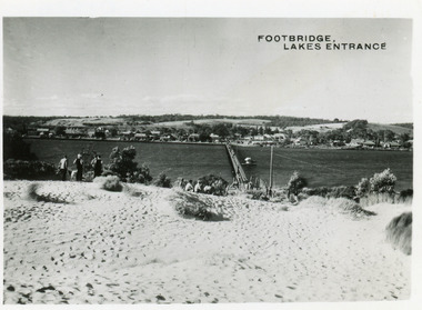 Lakes Entrance Historical Society
Postcard - Footbridge Lakes Entrance c1950
... Black and white small format postcard of footbridge over Cunninghame Arm. ...2 copies 6 x 9 Bridges Waterways Township People Footbridge Lakes Entrance Black and white small format postcard of footbridge over Cunninghame Arm. ...2 copies 6 x 9Black and white small format postcard of footbridge over Cunninghame Arm. It shows people on bare sand dunes in foreground boat moored beside bridge, motor vehicles parked along retaining wall on North shore with town buildings in background. Footbridge Lakes Entrancebridges, waterways, township, people -
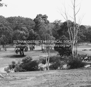 Eltham District Historical Society Inc
Photograph - Digital Photograph, Alan King, Alistair Knox Park, Eltham, 2008
... The bush-style plants, particularly around the creek, balance with open lawns, paths and a cascade flowing from a small lake to another below. A footbridge over the creek leads to the park’s west. ...The bush-style plants, particularly around the creek, balance with open lawns, paths and a cascade flowing from a small lake to another below. A footbridge over the creek leads to the park’s west. ...Alistair Knox Park, an oasis of peace and beauty. Covered under National Trust of Australia (Victoria) Landscape Significance and Heritage Overlay, Nillumbik Planning Scheme. Published: Nillumbik Now and Then / Marguerite Marshall 2008; photographs Alan King with Marguerite Marshall.; p173 It is hard to imagine that the Alistair Knox Park, an oasis of peace and beauty beside busy Main Road, Eltham, was once the township’s rubbish dump. It was only in the 1970s that the tip was transformed into this beautiful six hectare space, which later earned it a National Trust Landscape classification. Before its life as a dump, the area was used for small farms. Thanks largely to the foresight and efforts of local environmental builder Alistair Knox, the park was designed sympathetically with the character of the wider Eltham landscape. Then, appropriately, the park was named after Knox, who was an Eltham Shire Councillor from 1971 to 1975 and Shire President in 1975. The park designers were four major forces in the urban bush landscape garden –Knox, landscape designer Gordon Ford, artist Peter Glass and landscaper Ivan Stranger. The National Trust citation for the park, originally called Eltham Town Park, includes the Eltham railway trestle bridge and the Shillinglaw Cottage. The citation states ‘the semi-natural setting of the parkland provides a landscape which is evocative of the history of the area’. Manna Gums (Eucalyptus viminalis) and Candlebarks (Eucalyptus rubida) are significant features. Most of the park’s construction was directed by Bob Grant, Superintendent of the Parks and Gardens Department for the Eltham Shire Council. First plantings occurred in Arbour Week in 1973, then the lake and botanic area were completed in 1975, with Federal Government funding, and the toilet block in 1978. Bounded by the Eltham railway line, Panther Place, Main Road, Bridge and Susan Streets, the park is in a valley about a kilometre wide overlooked by steep hills at the east and west. The Diamond Creek flows through it and the picturesque historic timber trestle railway bridge edges the north. Informal plantings of Australian indigenous and native species in open and undulating grassed settings blend with the natural landscape of the Diamond Creek to the west. The bush-style plants, particularly around the creek, balance with open lawns, paths and a cascade flowing from a small lake to another below. A footbridge over the creek leads to the park’s west. The park includes an adventure playground and barbecue areas. The park stands on part of the land bought from the Crown in 1851 by Josiah Holloway, who subdivided it into allotments and which he called Little Eltham. Most of the land was subdivided into residential lots, but the creek valley, on which the park stands, was subdivided into farm-size lots, used mainly for orchards and grazing. One of the earliest owners was John Hicks Petty, who in 1874 bought a plot from Holloway. Other families who owned properties in that area, included Rees, Clark, Waterfall, Graham, Hill and Morant. In 1901 the railway was built through the area. Jock Read, an Eltham resident since around 1920, remembers several farms in the 1920s and ’30s that occupied the site of today’s park. A poultry farm, which extended from present day Panther Place, was owned by the Gahan family. Next to that farm was another for grazing cattle owned by Jack Carrucan. Beside this was land owned by John Lyon. A doctor lived beside this, and at the north-west corner of Bridge Street and Main Road stood a memorial to the soldiers who died in World War One, which was later moved to the RSL site. Mr Read also remembers other farms and orchards west of the creek In the early 1960s the Eltham Council began buying these farms and in the late 1960s turned the areas east of the Diamond Creek into a garbage tip. When this was filled above the creek’s flood plain, the tip was moved to the west of the creek.This collection of almost 130 photos about places and people within the Shire of Nillumbik, an urban and rural municipality in Melbourne's north, contributes to an understanding of the history of the Shire. Published in 2008 immediately prior to the Black Saturday bushfires of February 7, 2009, it documents sites that were impacted, and in some cases destroyed by the fires. It includes photographs taken especially for the publication, creating a unique time capsule representing the Shire in the early 21st century. It remains the most recent comprehenesive publication devoted to the Shire's history connecting local residents to the past. nillumbik now and then (marshall-king) collection, alistair knox park, eltham -
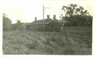
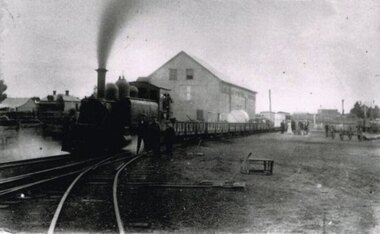 Otway Districts Historical Society
Photograph, Locomotive 8A and its mixed train at Colac Railway Station, c.1920, c.1920
... In 1922 a footbridge was erected over the broad gauge lines, and a passenger shelter and small goods shed were built on the departure track....In 1922 a footbridge was erected over the broad gauge lines, and a passenger shelter and small goods shed were built on the departure track. colac; railway; narrow gauge; na locomotive; B/W. ...Station facilities for the travelling public on the narrow gauge line at Colac Railway Station were non-existent for many years. Tickets were purchased from the broad gauge booking office and the travellers then had to walk with their luggage over the rough, potentially ankle-twisting, stone approaches, through the goods yard and wait in the open amongst the mud holes alongside the narrow gauge departure track. In 1922 a footbridge was erected over the broad gauge lines, and a passenger shelter and small goods shed were built on the departure track.B/W. At Colac Railway Station, an locomotive 8A with five NQR wagons, an NM livestock wagon and a NBDBD combined passenger and brake van destined for Beech Forest, with either the driver or the fireman peering out of the engine, three youths standing at the front of the engine, and a group of people, including a woman, standing near the livestock wagon. A multi-storied shed and two houses are in the background. 179mm x 280mm picture.colac; railway; narrow gauge; na locomotive; -
 Port Melbourne Historical & Preservation Society
Plan - Proposed footbridge over the Lagoon, Bridge Street, Port Melbourne, 1863
... Port Melbourne Historical & Preservation Society Port Melbourne Town Hall 333 Bay Street Port Melbourne melbourne Sandridge Lagoon Robert H MORGAN In ink on reverse, two small drawings: elevation land view over a distance of 25.00 chains (colour tinted), and Plan view, section of an unidentified street:In pencil on reverse, notation '107 Albert Street' Plan of proposed footbridge over the Lagoon in line of Bridge Street Plan Proposed footbridge over the Lagoon, Bridge Street, Port Melbourne ...Plan of proposed footbridge over the Lagoon in line of Bridge StreetIn ink on reverse, two small drawings: elevation land view over a distance of 25.00 chains (colour tinted), and Plan view, section of an unidentified street:In pencil on reverse, notation '107 Albert Street'sandridge lagoon, robert h morgan -
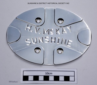 Sunshine and District Historical Society Incorporated
Memorabilia - Base plate for the New H.V.McKay Footbridge in Sunshine, Circa 2013-2014
... The plate is in our possession for safe keeping and for future reference. base plate stainless steel plate crossbar gates regional rail link hv mckay footbridge h.v.mckay footbridge sunshine H.V.McKAY SUNSHINE (The small c is underlined which can't be replicated on this data base) Stainless steel oval shaped plate with four holes for mounting to mesh sides of the walkway on the bridge. ...The steel mesh and crossbar sides of the new H.V.McKay footbridge are designed to replicate the appearance of the old crossbar gates which were at the old H.V.McKay works. The new bridge contains 111 of these plates attached to the centre of all crossbar sections which enclose both sides of the walkway of the bridge. The plate is a donated spare which was left over from the original manufactured plates that were attached to the new H.V.McKay footbridge. The plate is in our possession for safe keeping and for future reference.Stainless steel oval shaped plate with four holes for mounting to mesh sides of the walkway on the bridge. The plate has engraved lettering and lines intended to replicate a Sunshine Crossbar gate. H.V.McKAY SUNSHINE (The small c is underlined which can't be replicated on this data base)base plate, stainless steel plate, crossbar gates, regional rail link, hv mckay footbridge, h.v.mckay footbridge, sunshine -
 Lakes Entrance Historical Society
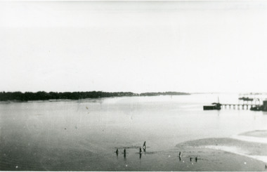
Photograph - Boat Harbour, Cunninghame Arm looking west. Lakes Entrance Victoria, 1940c
... small format photograph of Cunninghame Arm looking west. It shows the southern shore of the lake, and jetties on the opposite side of the lake. Photo taken from Cunninghame Arm footbridge...small format photograph of Cunninghame Arm looking west. It shows the southern shore of the lake, and jetties on the opposite side of the lake. Photo taken from Cunninghame Arm footbridge ...Black and white small format photograph of Cunninghame Arm looking west. It shows the southern shore of the lake, and jetties on the opposite side of the lake. Photo taken from Cunninghame Arm footbridge. Lakes Entrance Victoriajetties, waterfront -
 Lakes Entrance Historical Society
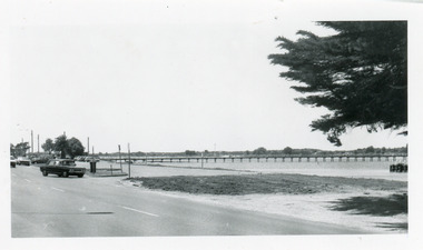
Photograph - Footbridge, footbridge and Princes Highway Lakes Entrance Victoria, 1990c
... Small format, black and white photograph of the footbridge and Princes Highway. ...Lakes Entrance Historical Society 4 Marine Parade Lakes Entrance gippsland Waterfront Foreshore Small format, black and white photograph of the footbridge and Princes Highway. ...Small format, black and white photograph of the footbridge and Princes Highway. It shows cars parked beside the road, footbridge, lake, and part of a WW1 memorial cypress tree in foreground. Lakes Entrance Victoria waterfront, foreshore -
 Lakes Entrance Historical Society
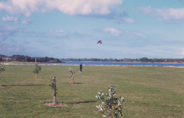
Photograph - Recreation Area Development Lakes Entrance, Lakes Post Newspaper, 1/04/1999 12:00:00 AM
... Also three colour photographs showing progress of recreation area east of the footbridge and instillation of rotunda. Small boy in foreground is Jarrod Elstob of Paynsville 04270.1, 04270.2, 04270.3 size 10 x 15 cm...Also three colour photographs showing progress of recreation area east of the footbridge and instillation of rotunda. Small boy in foreground is Jarrod Elstob of Paynsville 04270.1, 04270.2, 04270.3 size 10 x 15 cm Photograph Recreation Area Development Lakes Entrance Lakes Post Newspaper ...Colour photograph taken of the newly planted trees on the recreation area east of the footbridge. The artificially constructed knoll beside lake in the distance one person flying a kite from lawn Lakes Entrance Victoria. Also three colour photographs showing progress of recreation area east of the footbridge and instillation of rotunda. Small boy in foreground is Jarrod Elstob of Paynsville 04270.1, 04270.2, 04270.3 size 10 x 15 cmtownship, waterfront, recreation -
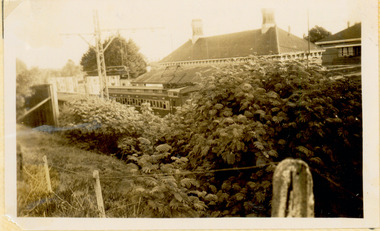
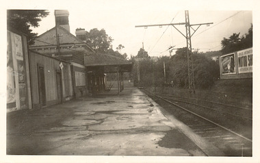
 Surrey Hills Historical Society Collection
Photograph, Surrey Hills Station and car park
... footbridge. According to Roderick Smith, a local railway enthusiast, originally there had been 3 railway houses at the Mont Albert end of the northern car park. These were demolished to extend the car park. Certainly 8 Bedford Avenue, built as the station master's house was demolished at this time. The palm tree had been planted in the station master's front garden and was retained in a small...footbridge. According to Roderick Smith, a local railway enthusiast, originally there had been 3 railway houses at the Mont Albert end of the northern car park. These were demolished to extend the car park. Certainly 8 Bedford Avenue, built as the station master's house was demolished at this time. The palm tree had been planted in the station master's front garden and was retained in a small ...There are 3 tracks; the third track was built in 1971, which gives an approximate date for the photo. At this time the original station buildings were demolished and replaced by buildings constructed from concrete bricks and a second subway replaced the overhead footbridge. According to Roderick Smith, a local railway enthusiast, originally there had been 3 railway houses at the Mont Albert end of the northern car park. These were demolished to extend the car park. Certainly 8 Bedford Avenue, built as the station master's house was demolished at this time. The palm tree had been planted in the station master's front garden and was retained in a small garden bed within the car park. A black and white photograph of a station with cars parked on both sides of the 3 tracks. A Harris train is departing the station heading towards Mont Albert. A palm tree is prominent in the station car park to the north.1971, surrey hills station, railway stations, car parks, public transport, trains, railway lines, palm tree -
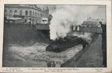 Kew Historical Society Inc
Postcard, R McGeehan, The Effect of Storm. Train Passing Through Flood Waters, South Yarra, 25-1-07, 1907
... small lake. Several shops were inundated, while the water from the higher levels rushed down like a mountain torrent, and in several in-stances swept through the rear of houses and shops, carrying furniture in a floating mass against the further walls. In one case a footbridge...small lake. Several shops were inundated, while the water from the higher levels rushed down like a mountain torrent, and in several in-stances swept through the rear of houses and shops, carrying furniture in a floating mass against the further walls. In one case a footbridge ...SHARP DOWNPOUR. ONE INCH IN 45 MINUTES. SOUTHERN SUBURBS DELUGED. TRAIN STOPPED AT SOUTH YARRA. One of the sudden downpours of rain which occasionally fall in Melbourne occurred yesterday afternoon, when nearly an inch of rain fell in the course of three quarters of an hour, and caused a flood for an hour or two in certain localities. During the early part of the day, the sky had been clouded over, but there was nothing to indicate a storm of such intensity as that which followed. At about half-past 1 o'clock residents of South Yarra, South Melbourne, Prahran, and St. Kilda noticed a few drops of rain. Still, it appeared unlikely that there would be anything exceptional, until with startling suddenness at about 10 minutes to 1 o'clock, one of the heaviest downpours within the memory of residents burst upon those suburbs. A strange feature of the storm was that it was practically confined to an area of about three miles square. The city was but little affected, though at a spot as close as the Observatory 86 points of rain were recorded in three-quarters of an hour. Thunder and lightning accompanied the downpour, which was cyclonic in character, the rain driving heavily from all points of the compass as the cyclone passed. It was in South Yarra and Prahran that the rain fell heaviest. Within a few minutes after it commenced, the low-lying portions of Toorak-road and practically the whole length of Chapel-street were under water. The depression at the intersection of Toorak-road and Darling-street speedily filled to the dimensions of a small lake. Several shops were inundated, while the water from the higher levels rushed down like a mountain torrent, and in several in-stances swept through the rear of houses and shops, carrying furniture in a floating mass against the further walls. In one case a footbridge was carried bodily away and dashed to pieces. Darling-street itself Great Davis-street, and other low-lying and flat thoroughfares in the vicinity became flooded from kerb to kerb, while on the other side of the railway-bridge the valley between Kensington-road and River-street became filled for some minutes to a depth of several feet. Meanwhile the waters from South Yarra hill, seeking a lower level, found it in the railway cutting, and the excavations from South Yarra station to Prahran on the one line, and to the Chapel-street bridge on the other, were converted into a couple of canals. At the platforms at South Yarra the water was two feet deep on the permanent way, and towards Hawksburn, at the sudden depression under Chapel-street bridge, it was at one time deep enough to cover a tall man's head. Into this swirling mass of water the 1:50 p.m. train from Oakleigh plunged on its way to Melbourne. The impact caused a mighty fountain of water to rise to a height of about 20 feet above the level of Chapel-street and send clouds of spray in all directions. Under the belief that a terrible explosion had occurred residents braved the rain and rushed to the spot, only to find that the train had been brought to a stand-still in the middle of what seemed to be a river. The water was so high that it had entered the fire-box from below, extinguishing the fires and cutting off the steam supply. In the meantime the officials at the South Yarra station had been preparing for emergencies. Inspectors were on duty at intervals along the line, and the moment the alarm was given an extra engine was backed carefully down and continued on to connect with the stranded train without losing its own power. There was a delay of about ten minutes in the service for an hour or two, but by 5 o'clock all the trains were running on time again, and the water had run off all but the spot beneath the Chapel-street bridge. Here the water remained about four feet deep until nightfall, and throughout the afternoon several hundreds of people including biograph operators and photographers, were gathered around watching each train pass through. Even with the water two feet lower, this was a work attended with considerable difficulty. Each train had to absolutely force its way through the weight of water, almost enveloped by the spray thrown up, and it was only just able to negotiate the "ford" by using every ounce of steam. ... The Argus, 26 January 1907, p19.The item forms part of the Laurie Bennett collection of thirty-six postcards and photographs of Kew and early Melbourne, donated to the Kew Historical Society in 1980. The postcards in the Bennett collection, like other images in the Society's holdings date from the 1890s to the present and comprehensively indicate points-of-view or scenes considered historically, aesthetically or socially significant in the period in which they were produced.Postcard depicting a flood at South Yarra Station in 1907. The title and photographer's name are identified on the front of the postcard. Donated by L. Bennett, 1980flood - south yarra, trains - melbourne, postcards, r mcgeehan - prahran -
 Mt Dandenong & District Historical Society Inc.
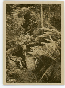
Photograph, Tourist Track, Sassafras, c1913
... Sassafras bridge footbridge Rose Series On reverse - Tourist Track, Sassafras Small b & w photograph from a series of 8 showing scenes from Sassafras produced by the Rose Stenograph Co. c1913. ...This set of 8 photographs was produced by the Rose Stenograph Co. c1913 to be included in photograph albums. They show tourist scenes of Sassafras and surrounds. The photographs were donated by a family in Western Australia whose parents lived in Sassafras c1918.Small b & w photograph from a series of 8 showing scenes from Sassafras produced by the Rose Stenograph Co. c1913.On reverse - Tourist Track, Sassafrassassafras, bridge, footbridge, rose series -
 Mt Dandenong & District Historical Society Inc.
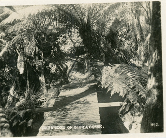
Photograph, Footbridge On Olinda Creek, late 1930s
... Small photograph, number 3 in Olinda series, showing footbridge over Olinda Creek surrounded by tree ferns. ...Olinda Creek footbridge bridge Olinda creek tree ferns ferns bush Small photograph, number 3 in Olinda series, showing footbridge over Olinda Creek surrounded by tree ferns. ...Number 3 in commercial series.Small photograph, number 3 in Olinda series, showing footbridge over Olinda Creek surrounded by tree ferns. Late 1930s.olinda creek, footbridge, bridge, olinda, creek, tree ferns, ferns, bush -
 Kew Historical Society Inc
Photograph - The last train at Barker Station, 1952
... footbridge at Hawthorn to change trains, and the main line trains were usually already crowded by the time they reached Hawthorn. At about the same time the off-peak trains were replaced by road buses. In 1952 all passenger trains were withdrawn, but the road bus service continued for many years. Goods trains were finally withdrawn in 1957, and the railway was dismantled in 1958-59. (Source: Frank Stamford, 'The Hawthorn - Kew Railway') Kew Railway Line Transport -- Railways -- kew (Vic.) Barker Railway Station Kew Branch LIne "Last train at Barker Station / 1 August 1952" Small ...The Kew railway was opened in 1887, and diverged from the main (Box Hill–Lilydale) line about half-way between Hawthorn and Glenferrie. From the point of divergence the line was slightly less than one mile long, and it had only one intermediate station — Barker. There were four road over-bridges and two level crossings, including one over the busy Barkers Road. The line supported a passenger and goods service, and was electrified in December 1922, at the same time as the main line to Box Hill. There were a number of peak hour services which ran from Flinders Street station (Melbourne) to Kew, but in 1938 all but one of these were diverted to the Ashburton line, where traffic was growing. This had an adverse effect on Kew traffic, as passengers from Kew needed to cross over a footbridge at Hawthorn to change trains, and the main line trains were usually already crowded by the time they reached Hawthorn. At about the same time the off-peak trains were replaced by road buses. In 1952 all passenger trains were withdrawn, but the road bus service continued for many years. Goods trains were finally withdrawn in 1957, and the railway was dismantled in 1958-59. (Source: Frank Stamford, 'The Hawthorn - Kew Railway')Small black and white snapshot of the last passenger train at Barker Railway Station in 1952. The photograph, one of 12, is part of a larger album of newspaper clippings, timetables, tickets and photos relating to the Kew Railway Line, taken and compiled by Lachlan Richardson, while a resident of Kew. The album dates from the 1950s. The album is part of a larger subject file on the Kew Line, compiled over time by members of the Kew Historical Society."Last train at Barker Station / 1 August 1952"kew railway line, transport -- railways -- kew (vic.), barker railway station, kew branch line -
 Kew Historical Society Inc
Photograph - Barker Station, August 1952
... footbridge at Hawthorn to change trains, and the main line trains were usually already crowded by the time they reached Hawthorn. At about the same time the off-peak trains were replaced by road buses. In 1952 all passenger trains were withdrawn, but the road bus service continued for many years. Goods trains were finally withdrawn in 1957, and the railway was dismantled in 1958-59. (Source: Frank Stamford, 'The Hawthorn - Kew Railway') Kew Railway Line Transport -- Railways -- kew (Vic.) Barker Railway Station Kew Branch LIne "Barker Station / August 1952" Small ...The Kew railway was opened in 1887, and diverged from the main (Box Hill–Lilydale) line about half-way between Hawthorn and Glenferrie. From the point of divergence the line was slightly less than one mile long, and it had only one intermediate station — Barker. There were four road over-bridges and two level crossings, including one over the busy Barkers Road. The line supported a passenger and goods service, and was electrified in December 1922, at the same time as the main line to Box Hill. There were a number of peak hour services which ran from Flinders Street station (Melbourne) to Kew, but in 1938 all but one of these were diverted to the Ashburton line, where traffic was growing. This had an adverse effect on Kew traffic, as passengers from Kew needed to cross over a footbridge at Hawthorn to change trains, and the main line trains were usually already crowded by the time they reached Hawthorn. At about the same time the off-peak trains were replaced by road buses. In 1952 all passenger trains were withdrawn, but the road bus service continued for many years. Goods trains were finally withdrawn in 1957, and the railway was dismantled in 1958-59. (Source: Frank Stamford, 'The Hawthorn - Kew Railway')Small black and white snapshot of the last passenger train at Barker Railway Station in 1952. The photograph, one of 12, is part of a larger album of newspaper clippings, timetables, tickets and photos relating to the Kew Railway Line, taken and compiled by Lachlan Richardson, while a resident of Kew. The album dates from the 1950s. The album is part of a larger subject file on the Kew Line, compiled over time by members of the Kew Historical Society."Barker Station / August 1952"kew railway line, transport -- railways -- kew (vic.), barker railway station, kew branch line -
 Kew Historical Society Inc
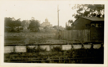
Photograph - Kew Railway Station: Denmark Street entrance, 1952
... footbridge at Hawthorn to change trains, and the main line trains were usually already crowded by the time they reached Hawthorn. At about the same time the off-peak trains were replaced by road buses. In 1952 all passenger trains were withdrawn, but the road bus service continued for many years. Goods trains were finally withdrawn in 1957, and the railway was dismantled in 1958-59. (Source: Frank Stamford, 'The Hawthorn - Kew Railway') Kew Railway Line Transport -- Railways -- kew (Vic.) Kew Branch LIne Kew Railway Station Small ...The Kew railway was opened in 1887, and diverged from the main (Box Hill–Lilydale) line about half-way between Hawthorn and Glenferrie. From the point of divergence the line was slightly less than one mile long, and it had only one intermediate station — Barker. There were four road over-bridges and two level crossings, including one over the busy Barkers Road. The line supported a passenger and goods service, and was electrified in December 1922, at the same time as the main line to Box Hill. There were a number of peak hour services which ran from Flinders Street station (Melbourne) to Kew, but in 1938 all but one of these were diverted to the Ashburton line, where traffic was growing. This had an adverse effect on Kew traffic, as passengers from Kew needed to cross over a footbridge at Hawthorn to change trains, and the main line trains were usually already crowded by the time they reached Hawthorn. At about the same time the off-peak trains were replaced by road buses. In 1952 all passenger trains were withdrawn, but the road bus service continued for many years. Goods trains were finally withdrawn in 1957, and the railway was dismantled in 1958-59. (Source: Frank Stamford, 'The Hawthorn - Kew Railway')Small black and white snapshot of the entrance to Kew Station from Denmark Street in 1952. The photograph, one of 12, is part of a larger album of newspaper clippings, timetables, tickets and photos relating to the Kew Railway Line, taken and compiled by Lachlan Richardson, while a resident of Kew. The album dates from the 1950s. The album is part of a larger subject file on the Kew Line, compiled over time by members of the Kew Historical Society.kew railway line, transport -- railways -- kew (vic.), kew branch line, kew railway station -
 Kew Historical Society Inc
Photograph - Kew Station 22/4/51, F3
... footbridge at Hawthorn to change trains, and the main line trains were usually already crowded by the time they reached Hawthorn. At about the same time the off-peak trains were replaced by road buses. In 1952 all passenger trains were withdrawn, but the road bus service continued for many years. Goods trains were finally withdrawn in 1957, and the railway was dismantled in 1958-59. (Source: Frank Stamford, 'The Hawthorn - Kew Railway') Kew Railway Line Transport -- Railways -- kew (Vic.) Kew Branch LIne kew railway station Small ...The Kew railway was opened in 1887, and diverged from the main (Box Hill–Lilydale) line about half-way between Hawthorn and Glenferrie. From the point of divergence the line was slightly less than one mile long, and it had only one intermediate station — Barker. There were four road over-bridges and two level crossings, including one over the busy Barkers Road. The line supported a passenger and goods service, and was electrified in December 1922, at the same time as the main line to Box Hill. There were a number of peak hour services which ran from Flinders Street station (Melbourne) to Kew, but in 1938 all but one of these were diverted to the Ashburton line, where traffic was growing. This had an adverse effect on Kew traffic, as passengers from Kew needed to cross over a footbridge at Hawthorn to change trains, and the main line trains were usually already crowded by the time they reached Hawthorn. At about the same time the off-peak trains were replaced by road buses. In 1952 all passenger trains were withdrawn, but the road bus service continued for many years. Goods trains were finally withdrawn in 1957, and the railway was dismantled in 1958-59. (Source: Frank Stamford, 'The Hawthorn - Kew Railway')Small black and white snapshot of Kew Railway Station, looking south to Barker Station. The photograph, one of 12, is part of a larger album of newspaper clippings, timetables, tickets and photos relating to the Kew Railway Line, taken and compiled by Lachlan Richardson, while a resident of Kew. The album dates from the 1950s. The album is part of a larger subject file on the Kew Line, compiled over time by members of the Kew Historical Society.kew railway line, transport -- railways -- kew (vic.), kew branch line, kew railway station -
 Kew Historical Society Inc
Photograph - Kew Branch Line : The Hawthorn Grove crossing, August 1952
... footbridge at Hawthorn to change trains, and the main line trains were usually already crowded by the time they reached Hawthorn. At about the same time the off-peak trains were replaced by road buses. In 1952 all passenger trains were withdrawn, but the road bus service continued for many years. Goods trains were finally withdrawn in 1957, and the railway was dismantled in 1958-59. (Source: Frank Stamford, 'The Hawthorn - Kew Railway') Kew Railway Line Transport -- Railways -- kew (Vic.) Kew Branch LIne Hawthorn Grove -- Hawthorn (Vic.) Railway crossings Small ...The Kew railway was opened in 1887, and diverged from the main (Box Hill–Lilydale) line about half-way between Hawthorn and Glenferrie. From the point of divergence the line was slightly less than one mile long, and it had only one intermediate station — Barker. There were four road over-bridges and two level crossings, including one over the busy Barkers Road. The line supported a passenger and goods service, and was electrified in December 1922, at the same time as the main line to Box Hill. There were a number of peak hour services which ran from Flinders Street station (Melbourne) to Kew, but in 1938 all but one of these were diverted to the Ashburton line, where traffic was growing. This had an adverse effect on Kew traffic, as passengers from Kew needed to cross over a footbridge at Hawthorn to change trains, and the main line trains were usually already crowded by the time they reached Hawthorn. At about the same time the off-peak trains were replaced by road buses. In 1952 all passenger trains were withdrawn, but the road bus service continued for many years. Goods trains were finally withdrawn in 1957, and the railway was dismantled in 1958-59. (Source: Frank Stamford, 'The Hawthorn - Kew Railway')Small black and white snapshot of the Hawthorn Grove crossing, August 1952. The photograph, one of 12, is part of a larger album of newspaper clippings, timetables, tickets and photos relating to the Kew Railway Line, taken and compiled by Lachlan Richardson, while a resident of Kew. The album dates from the 1950s. The album is part of a larger subject file on the Kew Line, compiled over time by members of the Kew Historical Society.kew railway line, transport -- railways -- kew (vic.), kew branch line, hawthorn grove -- hawthorn (vic.), railway crossings -
 Kew Historical Society Inc
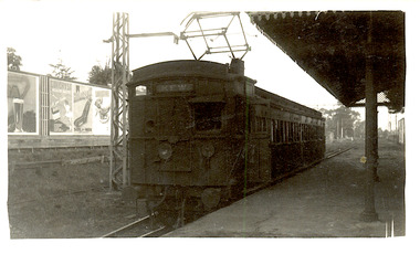
Photograph - Seven Carriage Train at Barker Station
... footbridge at Hawthorn to change trains, and the main line trains were usually already crowded by the time they reached Hawthorn. At about the same time the off-peak trains were replaced by road buses. In 1952 all passenger trains were withdrawn, but the road bus service continued for many years. Goods trains were finally withdrawn in 1957, and the railway was dismantled in 1958-59. (Source: Frank Stamford, 'The Hawthorn - Kew Railway') Kew Railway Line Transport -- Railways -- kew (Vic.) Barker Railway Station Kew Branch LIne "Seven Carriage Train at Barker Station" Small ...The Kew railway was opened in 1887, and diverged from the main (Box Hill–Lilydale) line about half-way between Hawthorn and Glenferrie. From the point of divergence the line was slightly less than one mile long, and it had only one intermediate station — Barker. There were four road over-bridges and two level crossings, including one over the busy Barkers Road. The line supported a passenger and goods service, and was electrified in December 1922, at the same time as the main line to Box Hill. There were a number of peak hour services which ran from Flinders Street station (Melbourne) to Kew, but in 1938 all but one of these were diverted to the Ashburton line, where traffic was growing. This had an adverse effect on Kew traffic, as passengers from Kew needed to cross over a footbridge at Hawthorn to change trains, and the main line trains were usually already crowded by the time they reached Hawthorn. At about the same time the off-peak trains were replaced by road buses. In 1952 all passenger trains were withdrawn, but the road bus service continued for many years. Goods trains were finally withdrawn in 1957, and the railway was dismantled in 1958-59. (Source: Frank Stamford, 'The Hawthorn - Kew Railway')Small black and white snapshot of a seven carriage train approaching Barker Railway Station. The photograph, one of 12, is part of a larger album of newspaper clippings, timetables, tickets and photos relating to the Kew Railway Line, taken and compiled by Lachlan Richardson, while a resident of Kew. The album dates from the 1950s. The album is part of a larger subject file on the Kew Line, compiled over time by members of the Kew Historical Society."Seven Carriage Train at Barker Station"kew railway line, transport -- railways -- kew (vic.), barker railway station, kew branch line -
 Kew Historical Society Inc
Photograph - Farewell to 'Our Lady of Fatima'. Xavier College 22/4/51
... footbridge at Hawthorn to change trains, and the main line trains were usually already crowded by the time they reached Hawthorn. At about the same time the off-peak trains were replaced by road buses. In 1952 all passenger trains were withdrawn, but the road bus service continued for many years. Goods trains were finally withdrawn in 1957, and the railway was dismantled in 1958-59. (Source: Frank Stamford, 'The Hawthorn - Kew Railway') Kew Railway Line Transport -- Railways -- kew (Vic.) Kew Branch LIne Xavier College kew railway station "Farewell to 'Our Lady of Fatima'. Xavier College 22/4/51" Small ...The Kew railway was opened in 1887, and diverged from the main (Box Hill–Lilydale) line about half-way between Hawthorn and Glenferrie. From the point of divergence the line was slightly less than one mile long, and it had only one intermediate station — Barker. There were four road over-bridges and two level crossings, including one over the busy Barkers Road. The line supported a passenger and goods service, and was electrified in December 1922, at the same time as the main line to Box Hill. There were a number of peak hour services which ran from Flinders Street station (Melbourne) to Kew, but in 1938 all but one of these were diverted to the Ashburton line, where traffic was growing. This had an adverse effect on Kew traffic, as passengers from Kew needed to cross over a footbridge at Hawthorn to change trains, and the main line trains were usually already crowded by the time they reached Hawthorn. At about the same time the off-peak trains were replaced by road buses. In 1952 all passenger trains were withdrawn, but the road bus service continued for many years. Goods trains were finally withdrawn in 1957, and the railway was dismantled in 1958-59. (Source: Frank Stamford, 'The Hawthorn - Kew Railway')Small black and white snapshot of a train leaving Kew Station with the Xavier Chapel on the hill in the background, hence the ironic title provided by the photographer. The photograph, one of 12, is part of a larger album of newspaper clippings, timetables, tickets and photos relating to the Kew Railway Line, taken and compiled by Lachlan Richardson, while a resident of Kew. The album dates from the 1950s. The album is part of a larger subject file on the Kew Line, compiled over time by members of the Kew Historical Society."Farewell to 'Our Lady of Fatima'. Xavier College 22/4/51"kew railway line, transport -- railways -- kew (vic.), kew branch line, xavier college, kew railway station -
 Kew Historical Society Inc
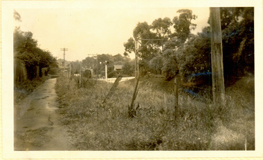
Photograph - Kew Branch Line: Looking along cutting towards Barker Station 22/4/51
... footbridge at Hawthorn to change trains, and the main line trains were usually already crowded by the time they reached Hawthorn. At about the same time the off-peak trains were replaced by road buses. In 1952 all passenger trains were withdrawn, but the road bus service continued for many years. Goods trains were finally withdrawn in 1957, and the railway was dismantled in 1958-59. (Source: Frank Stamford, 'The Hawthorn - Kew Railway') Kew Railway Line Transport -- Railways -- kew (Vic.) Barker Railway Station Kew Branch LIne "Looking along cutting towards Barker Station 22/4/51" Small ...The Kew railway was opened in 1887, and diverged from the main (Box Hill–Lilydale) line about half-way between Hawthorn and Glenferrie. From the point of divergence the line was slightly less than one mile long, and it had only one intermediate station — Barker. There were four road over-bridges and two level crossings, including one over the busy Barkers Road. The line supported a passenger and goods service, and was electrified in December 1922, at the same time as the main line to Box Hill. There were a number of peak hour services which ran from Flinders Street station (Melbourne) to Kew, but in 1938 all but one of these were diverted to the Ashburton line, where traffic was growing. This had an adverse effect on Kew traffic, as passengers from Kew needed to cross over a footbridge at Hawthorn to change trains, and the main line trains were usually already crowded by the time they reached Hawthorn. At about the same time the off-peak trains were replaced by road buses. In 1952 all passenger trains were withdrawn, but the road bus service continued for many years. Goods trains were finally withdrawn in 1957, and the railway was dismantled in 1958-59. (Source: Frank Stamford, 'The Hawthorn - Kew Railway')Small black and white snapshot looking along cutting towards Barker Station 22/4/51. The photograph, one of 12, is part of a larger album of newspaper clippings, timetables, tickets and photos relating to the Kew Railway Line, taken and compiled by Lachlan Richardson, while a resident of Kew. The album dates from the 1950s. The album is part of a larger subject file on the Kew Line, compiled over time by members of the Kew Historical Society."Looking along cutting towards Barker Station 22/4/51"kew railway line, transport -- railways -- kew (vic.), barker railway station, kew branch line -
 Kew Historical Society Inc
Photograph - The last train at Kew Station, August 1952
... footbridge at Hawthorn to change trains, and the main line trains were usually already crowded by the time they reached Hawthorn. At about the same time the off-peak trains were replaced by road buses. In 1952 all passenger trains were withdrawn, but the road bus service continued for many years. Goods trains were finally withdrawn in 1957, and the railway was dismantled in 1958-59. (Source: Frank Stamford, 'The Hawthorn - Kew Railway') Kew Railway Line Transport -- Railways -- kew (Vic.) Kew Branch LIne Kew Railway Station "The last train at Kew Station, August 1952" Small ...The Kew railway was opened in 1887, and diverged from the main (Box Hill–Lilydale) line about half-way between Hawthorn and Glenferrie. From the point of divergence the line was slightly less than one mile long, and it had only one intermediate station — Barker. There were four road over-bridges and two level crossings, including one over the busy Barkers Road. The line supported a passenger and goods service, and was electrified in December 1922, at the same time as the main line to Box Hill. There were a number of peak hour services which ran from Flinders Street station (Melbourne) to Kew, but in 1938 all but one of these were diverted to the Ashburton line, where traffic was growing. This had an adverse effect on Kew traffic, as passengers from Kew needed to cross over a footbridge at Hawthorn to change trains, and the main line trains were usually already crowded by the time they reached Hawthorn. At about the same time the off-peak trains were replaced by road buses. In 1952 all passenger trains were withdrawn, but the road bus service continued for many years. Goods trains were finally withdrawn in 1957, and the railway was dismantled in 1958-59. (Source: Frank Stamford, 'The Hawthorn - Kew Railway')Small black and white snapshot of the last passenger train at Kew Railway Station in 1952. The photograph, one of 12, is part of a larger album of newspaper clippings, timetables, tickets and photos relating to the Kew Railway Line, taken and compiled by Lachlan Richardson, while a resident of Kew. The album dates from the 1950s. The album is part of a larger subject file on the Kew Line, compiled over time by members of the Kew Historical Society."The last train at Kew Station, August 1952"kew railway line, transport -- railways -- kew (vic.), kew branch line, kew railway station -
 Kew Historical Society Inc
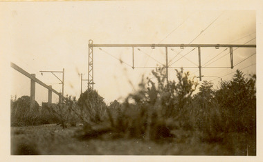
Photograph - Kew Branch Line: Weeds at Kew Station 14/51
... footbridge at Hawthorn to change trains, and the main line trains were usually already crowded by the time they reached Hawthorn. At about the same time the off-peak trains were replaced by road buses. In 1952 all passenger trains were withdrawn, but the road bus service continued for many years. Goods trains were finally withdrawn in 1957, and the railway was dismantled in 1958-59. (Source: Frank Stamford, 'The Hawthorn - Kew Railway') Kew Railway Line Transport -- Railways -- kew (Vic.) Barker Railway Station Kew Branch LIne Small ...The Kew railway was opened in 1887, and diverged from the main (Box Hill–Lilydale) line about half-way between Hawthorn and Glenferrie. From the point of divergence the line was slightly less than one mile long, and it had only one intermediate station — Barker. There were four road over-bridges and two level crossings, including one over the busy Barkers Road. The line supported a passenger and goods service, and was electrified in December 1922, at the same time as the main line to Box Hill. There were a number of peak hour services which ran from Flinders Street station (Melbourne) to Kew, but in 1938 all but one of these were diverted to the Ashburton line, where traffic was growing. This had an adverse effect on Kew traffic, as passengers from Kew needed to cross over a footbridge at Hawthorn to change trains, and the main line trains were usually already crowded by the time they reached Hawthorn. At about the same time the off-peak trains were replaced by road buses. In 1952 all passenger trains were withdrawn, but the road bus service continued for many years. Goods trains were finally withdrawn in 1957, and the railway was dismantled in 1958-59. (Source: Frank Stamford, 'The Hawthorn - Kew Railway')Small black and white snapshot of how the Kew Branch Line was allowed to run down. The photograph, one of 12, is part of a larger album of newspaper clippings, timetables, tickets and photos relating to the Kew Railway Line, taken and compiled by Lachlan Richardson, while a resident of Kew. The album dates from the 1950s. The album is part of a larger subject file on the Kew Line, compiled over time by members of the Kew Historical Society.kew railway line, transport -- railways -- kew (vic.), barker railway station, kew branch line -
 Kew Historical Society Inc
Photograph - Kew Railway Station, May 1950
... footbridge at Hawthorn to change trains, and the main line trains were usually already crowded by the time they reached Hawthorn. At about the same time the off-peak trains were replaced by road buses. In 1952 all passenger trains were withdrawn, but the road bus service continued for many years. Goods trains were finally withdrawn in 1957, and the railway was dismantled in 1958-59. (Source: Frank Stamford, 'The Hawthorn - Kew Railway') Kew Railway Line Transport -- Railways -- kew (Vic.) Kew Branch LIne Kew Railway Station "Kew Railway Station, May 1950" Small ...The Kew railway was opened in 1887, and diverged from the main (Box Hill–Lilydale) line about half-way between Hawthorn and Glenferrie. From the point of divergence the line was slightly less than one mile long, and it had only one intermediate station — Barker. There were four road over-bridges and two level crossings, including one over the busy Barkers Road. The line supported a passenger and goods service, and was electrified in December 1922, at the same time as the main line to Box Hill. There were a number of peak hour services which ran from Flinders Street station (Melbourne) to Kew, but in 1938 all but one of these were diverted to the Ashburton line, where traffic was growing. This had an adverse effect on Kew traffic, as passengers from Kew needed to cross over a footbridge at Hawthorn to change trains, and the main line trains were usually already crowded by the time they reached Hawthorn. At about the same time the off-peak trains were replaced by road buses. In 1952 all passenger trains were withdrawn, but the road bus service continued for many years. Goods trains were finally withdrawn in 1957, and the railway was dismantled in 1958-59. (Source: Frank Stamford, 'The Hawthorn - Kew Railway')Small black and white snapshot of Kew Railway Station inMay 1950. The photograph, one of 12, is part of a larger album of newspaper clippings, timetables, tickets and photos relating to the Kew Railway Line, taken and compiled by Lachlan Richardson, while a resident of Kew. The album dates from the 1950s. The album is part of a larger subject file on the Kew Line, compiled over time by members of the Kew Historical Society."Kew Railway Station, May 1950"kew railway line, transport -- railways -- kew (vic.), kew branch line, kew railway station -
 Kew Historical Society Inc
Photograph - Kew Railway Station, 1951
... footbridge at Hawthorn to change trains, and the main line trains were usually already crowded by the time they reached Hawthorn. At about the same time the off-peak trains were replaced by road buses. In 1952 all passenger trains were withdrawn, but the road bus service continued for many years. Goods trains were finally withdrawn in 1957, and the railway was dismantled in 1958-59. (Source: Frank Stamford, 'The Hawthorn - Kew Railway') Kew Railway Line Transport -- Railways -- kew (Vic.) Kew Branch LIne Kew Railway Station "Kew Station / 14/51 / 22/4/51 F5" Small ...The Kew railway was opened in 1887, and diverged from the main (Box Hill–Lilydale) line about half-way between Hawthorn and Glenferrie. From the point of divergence the line was slightly less than one mile long, and it had only one intermediate station — Barker. There were four road over-bridges and two level crossings, including one over the busy Barkers Road. The line supported a passenger and goods service, and was electrified in December 1922, at the same time as the main line to Box Hill. There were a number of peak hour services which ran from Flinders Street station (Melbourne) to Kew, but in 1938 all but one of these were diverted to the Ashburton line, where traffic was growing. This had an adverse effect on Kew traffic, as passengers from Kew needed to cross over a footbridge at Hawthorn to change trains, and the main line trains were usually already crowded by the time they reached Hawthorn. At about the same time the off-peak trains were replaced by road buses. In 1952 all passenger trains were withdrawn, but the road bus service continued for many years. Goods trains were finally withdrawn in 1957, and the railway was dismantled in 1958-59. (Source: Frank Stamford, 'The Hawthorn - Kew Railway')Small black and white snapshot of Kew Railway Station in 1950. The photograph, one of 12, is part of a larger album of newspaper clippings, timetables, tickets and photos relating to the Kew Railway Line, taken and compiled by Lachlan Richardson, while a resident of Kew. The album dates from the 1950s. The album is part of a larger subject file on the Kew Line, compiled over time by members of the Kew Historical Society."Kew Station / 14/51 / 22/4/51 F5"kew railway line, transport -- railways -- kew (vic.), kew branch line, kew railway station -
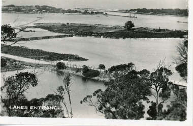 Lakes Entrance Historical Society
Postcard - Bullock Island Lakes Entrance c1920, c1920
... small format postcard of Bullock Island. It shows the approaches to the concrete bridge over the North Arm, the footbridge to Bullock Island, the entrance to the Gippsland Lakes from Bass Strait and part of the township on the hummocks. ...small format postcard of Bullock Island. It shows the approaches to the concrete bridge over the North Arm, the footbridge to Bullock Island, the entrance to the Gippsland Lakes from Bass Strait and part of the township on the hummocks. ...1 x Faded miniature postcard 6.5 x 8.5|1 x Black and white 9.5 x 12 copied from album in private hands|1 x Sepia toned 10 x 15|1 x Black and white 12 x 17.5Black and white small format postcard of Bullock Island. It shows the approaches to the concrete bridge over the North Arm, the footbridge to Bullock Island, the entrance to the Gippsland Lakes from Bass Strait and part of the township on the hummocks. Lakes Entrance VictoriaLakes Entrancewaterways, topography, islands, bridges