Showing 20 items matching "soil studies"
-
 Tatura Irrigation & Wartime Camps Museum
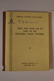
Book, Department of Agriculture Victori, Soil and Land Use in Part of the Goulburn Valley Victoria Technical Bulletin No 14, 1962
... ...soil studies Victoria...Contains maps and soil studies relating the the Goulburn Valley....Goulburn Valley soil studies Victoria Victorian maps Mid sized book with soft cover, brown spine with off white cover. ...Mid sized book with soft cover, brown spine with off white cover. Black writing on back and front. Contains maps. Tech Bulletin No 14.non-fictiongoulburn valley, soil studies victoria, victorian maps -
 Federation University Historical Collection
Book - Scrapbook, Ballarat School of Mines Scrapbook,1961-1966, 1961-1966
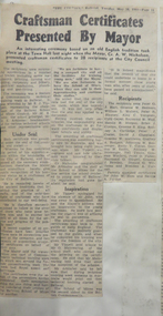
... ...soil studies...Barker Library (top floor) Mount Helen goldfields r.w. richards dick richards john gilbert ceramics e.w. doney antarctica city of ballarat craftsmen certificates scrap book ken wach bjts fees register allen bourquin p. collier j. crisp john dulfer fenner, charles gillin, murray gray, thomas j. graham hopwood hunting, f wesley lancaster landells, r. lochhead, j.s. lochhead, james mctaggert, mavis mcvitty henry moritz moritz, henry kathleen rice albert w. steane stevens, don kenneth wach ian g. whitcher noel whitcher a.m (bill) wilkinson harold yates international students asian students richard tan jack tay andrew vu zulkilfie h. abdullah sebastopol technical school foundations charles fenner e. elsbury c. o'toole w. lancaster v. nicholson douglas vendy richards medal william hudson a.j. bethune ballarat school of mines workshops m.y. jamagagni peter agrums thai j. boonsoong h. trudinger kevin whiter brewery chimney murray gillan don stevens bella guerin hester darby retirement rubie lonie cadets f.g. procter retirement albert coates d.e. richardson lydiard st closure geoff brown neville bunning walter reimann robert norton jill norton b. bryan kaspars bitans martin report edith lawn mavis mctaggart retirement richard chong zulkiflie h. abdullah alumni ian whitcher l.f.j. hillman h. elliott hester darby duke of edinburgh philips electrical industries pty ltd lois morris ballarat school of mines banner embroidery craftsman certificate technical training week apprenticeships 3rd university generator j.j. skuja sebastopol technical school pine plantation art students centenary medal bathtub race tippett hall bath tub run metallurgy lydiard street closure honor blazer soil studies rolls royce car engine jon rowe' allan bourquin ruby loney lindsay hillman yates geological centre geoffrey mainwawaring ballarat school of mines renovations ross gray casper bitans apprenticeship training boat race apprenticeship week f.g. proctor mount clear site john jungwirth ballarat school of mines open night wayne johnson j. hanford stevens peter richards r.c. chan mavis mctaggert gladstone procter Newspaper clippings relating to the Ballarat School of Mines and its students. ...Newspaper clippings relating to the Ballarat School of Mines and its students. This also includes the Ballarat Junior Technical School and the Ballarat Girls' Technical School. Selected items * Courier 27 May 1961 - Apprenticeship - Training Today for Tomorrow * Courier 22 February 1922 - Hopes for University Education in 1963 * More Women Graduates Needed * 30 July 1963 - Linking Technical and Liberal Education Streams * Courier 2 November - SMB's New Role in New Syllabus * 23 November 1963 0 New School Diploma courses explained * Courier 31 March 1964 - Artists and art critics: What young people thought of art show. * The Age, 25 March 1965 - Martin Report Urges Extension of High Education * Courier 11 June 1965 - Nuclear Power Won't be Missedr.w. richards, dick richards, john gilbert, ceramics, e.w. doney, antarctica, city of ballarat craftsmen certificates, scrap book, ken wach, bjts fees register, allen bourquin, p. collier, j. crisp, john dulfer, fenner, charles, gillin, murray, gray, thomas, j. graham hopwood, hunting, f, wesley lancaster, landells, r., lochhead, j.s., lochhead, james, mctaggert, mavis, mcvitty, henry moritz, moritz, henry, kathleen rice, albert w. steane, stevens, don, kenneth wach, ian g. whitcher, noel whitcher, a.m (bill) wilkinson, harold yates, international students, asian students, richard tan, jack tay, andrew vu, zulkilfie h. abdullah, sebastopol technical school foundations, charles fenner, e. elsbury, c. o'toole, w. lancaster, v. nicholson, douglas vendy, richards medal, william hudson, a.j. bethune, ballarat school of mines workshops, m.y. jamagagni, peter agrums, thai, j. boonsoong, h. trudinger, kevin whiter, brewery chimney, murray gillan, don stevens, bella guerin, hester darby retirement, rubie lonie, cadets, f.g. procter retirement, albert coates, d.e. richardson, lydiard st closure, geoff brown, neville bunning, walter reimann, robert norton, jill norton, b. bryan, kaspars bitans, martin report, edith lawn, mavis mctaggart retirement, richard chong, zulkiflie h. abdullah, alumni, ian whitcher, l.f.j. hillman, h. elliott, hester darby, duke of edinburgh, philips electrical industries pty ltd, lois morris, ballarat school of mines banner, embroidery, craftsman certificate, technical training week, apprenticeships, 3rd university, generator, j.j. skuja, sebastopol technical school, pine plantation, art students, centenary medal, bathtub race, tippett hall, bath tub run, metallurgy, lydiard street closure, honor blazer, soil studies, rolls royce car engine, jon rowe', allan bourquin, ruby loney, lindsay hillman, yates geological centre, geoffrey mainwawaring, ballarat school of mines renovations, ross gray, casper bitans, apprenticeship training, boat race, apprenticeship week, f.g. proctor, mount clear site, john jungwirth, ballarat school of mines open night, wayne johnson, j. hanford stevens, peter richards, r.c. chan, mavis mctaggert, gladstone procter -
 Bendigo Historical Society Inc.
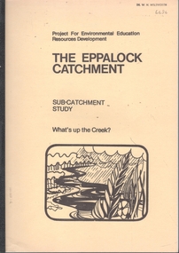
Booklet - The Eppalock Catchment
... Includes a diagram of the Water Cycle, 2 maps of the Pohlman's Creek Catchment and Soil Studies. Also includes Pre-Excursion, Excursion and Post- Excursion Activities as well as Record Sheets for Excursions. ...Includes a diagram of the Water Cycle, 2 maps of the Pohlman's Creek Catchment and Soil Studies. Also includes Pre-Excursion, Excursion and Post- Excursion Activities as well as Record Sheets for Excursions. ...Yellow covered booklet of 36 typed and copied pages entitled 'Project for Environmental Education Resources Development. THE EPPALOCK CATCHMENT Sub-Catchment What's Up the Creek? A Resource for Teachers. Includes a diagram of the Water Cycle, 2 maps of the Pohlman's Creek Catchment and Soil Studies. Also includes Pre-Excursion, Excursion and Post- Excursion Activities as well as Record Sheets for Excursions. The name 'Dr W.N.Holsworth' is stamped on the front cover and the date 29 April 1981lake eppalock, catchment study, teachers' resource -
 University of Melbourne, Burnley Campus Archives
Certificate - Award Certificate, Department of Agriculture, Victoria, Burnley Horticultural College, Certificate in Horticultural Studies, 1982
... Department of Agriculture Victoria Burnley Horticultural College CERTIFICATE IN HORTICULTURAL STUDIES Awarded to PETER DWAN on the completion of eight units each of thirty hours part-time study at the levels shown below Plant Function A Plant Reproduction A Soil Studies A Plant Studies B Ornamental A Entomology A Propagation A Plant Pathology A Signed by the director General David Smith Principal James Davis dated this eighteenth day of December 1982 ...Unclaimed and returned to the College. peter dwan students graduates Department of Agriculture Victoria Certificate in Horticultural Studies Department of Agriculture Victoria Burnley Horticultural College CERTIFICATE IN HORTICULTURAL STUDIES Awarded to PETER DWAN on the completion of eight units each of thirty hours part-time study at the levels shown below Plant Function A Plant Reproduction A Soil Studies A Plant Studies B Ornamental A Entomology A Propagation A Plant Pathology A Signed by the director General David Smith Principal James Davis dated this eighteenth day of December 1982 Certificate awarded to Peter Dwan 18.12.1982. ...Certificate awarded to Peter Dwan 18.12.1982. Unclaimed and returned to the College.Certificate awarded to Peter Dwan 18.12.1982. Signed and stamped Department of Agriculture Victoria with unclaimed postage mail tube "Return to Sender"Department of Agriculture Victoria Burnley Horticultural College CERTIFICATE IN HORTICULTURAL STUDIES Awarded to PETER DWAN on the completion of eight units each of thirty hours part-time study at the levels shown below Plant Function A Plant Reproduction A Soil Studies A Plant Studies B Ornamental A Entomology A Propagation A Plant Pathology A Signed by the director General David Smith Principal James Davis dated this eighteenth day of December 1982 peter dwan, students, graduates, department of agriculture victoria, certificate in horticultural studies -
 Eltham District Historical Society Inc
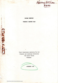
Document - Report, Tract Consultants Australia Pty Ltd, Eltham Cemetery: Towards a Master Plan, Nov 1987
... Before commencing the study in detail, additional basic information was sought; viz: a) sub-soil and rock analysis; and b) feature survey by a Licensed Surveyor. ...Before commencing the study in detail, additional basic information was sought; viz: a) sub-soil and rock analysis; and b) feature survey by a Licensed Surveyor. ...BACKGROUND The Eltham Cemetery is of historic significance to the Eltham area. The Trust was established in 1858 and has administered and maintained the cemetery from that date right up to the present. Among the more noteworthy graves is that of Sir William Irvine, a former State Premier and Chief Justice of Victoria. Eltham Cemetery is surrounded on three sides by urban development. Montsalvat Artists Colony adjoins the remaining (eastern) side. A Joint Select Committee of Parliament called the “Mortuary Industry and Cemeteries Administration Committee" (MICA) enquired into the land requirements at the Eltham Cemetery in 1986. The MICA recommendations contained in its 1986 report are included in the Appendices attached to this report. Although the recommendations have not been adopted by the Government it is interesting to note that the MICA report recommended the use of the bulk of the land for cemetery purpose. In June of 1987, the Cemetery Trust was expanded to include additional members from the Eltham Community by the Minister for Health. At the same time, he instructed the Trust to resolve the land requirement issues. As a result of this Ministerial direction, Tract Consultants has been instructed by the Eltham Cemetery Trust to prepare a report addressing the issues raised in the Minister's letter (see Appendix 1) to the Trust. Principally, the study will examine options available for development of the Cemetery. These options will explore possible boundaries, cemetery design, vegetation, the overall environment, landscaping and financial planning for the Cemetery operations. Appendix 2 details the Cemetery Trusts Terms of Reference for the Study. Before commencing the study in detail, additional basic information was sought; viz: a) sub-soil and rock analysis; and b) feature survey by a Licensed Surveyor. The results from both exercises are included as appendices to this report. Section three includes a summary of the findings along with other analytical results. Also: Eltham Cemetery - planning bewteen 1859 to 1860; research by Alan Sheehan April 2015, collated by Harry Gilham, EDHS, April 2016 (2 pages) PROV Guide 5: Cemetery Records (8 pages), printed 7 May 2014Development of Eltham Cemeteryeltham cemetery trust, master plan, mica, montsalvat, mortuary industry and cemeteries administration committee, tract consultants -
 Eltham District Historical Society Inc
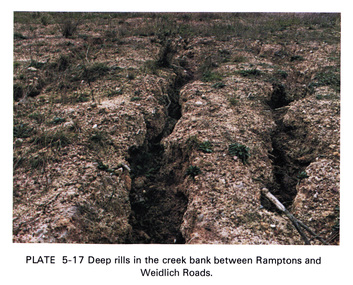
Work on paper (Sub-Item) - Photograph, Deep rills in the creek bank between Rampstons and Weidlich Roads
... The shallow channels are cut into the soil by the erosive action of flowing water. eltham creek bank erosion eltham north Image printed on A4 page from 04997 Diamond Creek Basin Study, 1980 Deep rills in the creek bank between Rampstons and Weidlich Roads Work on paper Photograph ...Colour photograph of deep rills in the Diamond Creek bank between Rampstons and Weidlich Roads, Eltham North. The shallow channels are cut into the soil by the erosive action of flowing water.eltham, creek bank, erosion, eltham north -
 Eltham District Historical Society Inc
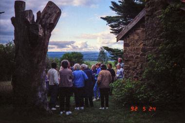
Photograph, Woodburn residence, mudbrick adobe (1949), Eltham Heritage Tour, 24 May 1992, 24/05/1992
... In the three and a half months they made over 3000 bricks (external walls 18" x 12" x 4", internal walls 12" x 9" x 4"), sifted top soil for mortar and laid them, on concrete foundations and slab floor, made all the structural window frames, door frames and roof members to carry 'super six' asbestos sheets, laboured for the electrician and plumber, did all the glazing and, still without electricity, moved in in March 1949. Rooms have been added, at first with glass walls, later using concrete blocks, to accommodate three daughters and a son. The house not only grew from the earth, but also with the family." Record of the Society's history and activities and highlighting various aspects of the Heritage Study ...ELTHAM HERITAGE TOUR The Society excursion on 24th May 1992 was arranged by David Bick, leader of the team carrying out the Shire's heritage study. David selected a number of sites or buildings identified in the study, some of them lesser known components of the Shire's heritage. The tour commenced at the Eltham Shire Office at 10.00 am. Travel was by private car and mini-bus with stops at about twelve locations for commentary by David.It included a short walk in Hurstbridge and lunch at Kinglake. Highlights of the tour included: - 10 am Leave from Shire Offices - 3 Important Trees - A Physical Link to Eltham's First Settlers - Toorak Mansion Gates - A Surviving Farm House - An Intact Circa 1900 Main Street - First Settlers - Gold Miners, and Timber-getters - An Early Hotel - A Pioneering Homestead - Changing Eltham Shire - 20th Century - 4 pm Afternoon Tea and Finish Tour Extract from ELTHAM CULTURAL HERITAGE TOUR (Newsletter No. 85, July 1992, by Bettina Woodburn) "In some respects Eltham is a 'back-water' and it has its own distinctive flavour. On the outskirts the homes date from the 1960's, 70's and 80s with a sprinkling of 'earth homes', mud-brick or pise, rammed dirt. Crossing Main Road into Beddoe Street and Thompson Crescent a very pleasant drive past pines and old fence lines, front lawns unfenced, the occasional ·old farm building, we eventually looked down on a huge circular roof of a 1992 adobe home. Other distinctive places included the Pauline Toner Butterfly Reserve, Gordon Ford's splendid garden at Fulling in Pitt Street, cypress hedges and old houses in Bridge Street and in every direction Eltham's special feature - a totally treed horizon. We were now in the part of the Shire closest to Melbourne - Montmorency - not on the way to anywhere, with no through road going across it, developed in the 1950's and 1960's with conventional gardens, now converted to native plants. The rail looped between Greensborough and Eltham and a shopping street (Were Street) served the area, growing up the hill from the station. It was a typical outer Melbourne suburb with lawns and roses with patches of originality. The shopping precinct still has 1950 characteristics - walls which sloped back, projecting roofs, the original shop fronts are nearly all tiled below the old windows. There's an air of past times about the School, the Dairy, the Butcher's (now a milk bar) and the Castlemaine stone face of the Commonwealth Bank. The final stop for the tour was at the mud-brick Woodburn residence, adobe of 1949 with additions. After War Service, Bill Woodburn had commenced an Architecture course at Melbourne University and after second year in the Christmas vacation, with his wife, Betti, built the two bedroom house - with amazing saving of costs. In the three and a half months they made over 3000 bricks (external walls 18" x 12" x 4", internal walls 12" x 9" x 4"), sifted top soil for mortar and laid them, on concrete foundations and slab floor, made all the structural window frames, door frames and roof members to carry 'super six' asbestos sheets, laboured for the electrician and plumber, did all the glazing and, still without electricity, moved in in March 1949. Rooms have been added, at first with glass walls, later using concrete blocks, to accommodate three daughters and a son. The house not only grew from the earth, but also with the family."Record of the Society's history and activities and highlighting various aspects of the Heritage Study undertaken by David Bick used to create the future heritage overlay for the Shire of Eltham and later Nillumbik Shire.Roll of 35mm colour negative film, 4 stripsKodak Gold 100 5095shire of eltham historical society, activities, heritage tour, woodburn house -
 Eltham District Historical Society Inc
Photograph, Kangaroo Ground War Memorial, Eltham Heritage Tour, 24 May 1992, 24/05/1992
... soil of this ancient volcano, its crater lost under subsequent weathering, was rich, deserving the name of "Garden Hill". Now native trees are taking over again. In Kangaroo Ground itself stand the inevitable Store, School and Church - and two Norfolk pines and a monkey puzzle tree." Record of the Society's history and activities and highlighting various aspects of the Heritage Study ...ELTHAM HERITAGE TOUR The Society excursion on 24th May 1992 was arranged by David Bick, leader of the team carrying out the Shire's heritage study. David selected a number of sites or buildings identified in the study, some of them lesser known components of the Shire's heritage. The tour commenced at the Eltham Shire Office at 10.00 am. Travel was by private car and mini-bus with stops at about twelve locations for commentary by David.It included a short walk in Hurstbridge and lunch at Kinglake. Highlights of the tour included: - 10 am Leave from Shire Offices - 3 Important Trees - A Physical Link to Eltham's First Settlers - Toorak Mansion Gates - A Surviving Farm House - An Intact Circa 1900 Main Street - First Settlers - Gold Miners, and Timber-getters - An Early Hotel - A Pioneering Homestead - Changing Eltham Shire - 20th Century - 4 pm Afternoon Tea and Finish Tour Extract from ELTHAM CULTURAL HERITAGE TOUR (Newsletter No. 85, July 1992, by Bettina Woodburn) "Now we drove through stands of pines to the Kangaroo Ground Lookout Tower, a most unusual War Memorial, World War I. The tower and a shed/residence (it had a chimney) were built from local sandstone. Below to the south and east of Melbourne spread 'suburbia'. Close by the landscape seemed so contrived - English fields and hedgerows! Although only about twenty inches deep, the soil of this ancient volcano, its crater lost under subsequent weathering, was rich, deserving the name of "Garden Hill". Now native trees are taking over again. In Kangaroo Ground itself stand the inevitable Store, School and Church - and two Norfolk pines and a monkey puzzle tree."Record of the Society's history and activities and highlighting various aspects of the Heritage Study undertaken by David Bick used to create the future heritage overlay for the Shire of Eltham and later Nillumbik Shire.Roll of 35mm colour negative film, 4 stripsKodak Gold 100 5095shire of eltham historical society, activities, heritage tour, kangaroo ground, kangaroo ground tower, war memorials, kangaroo ground memorial -
 Otway Districts Historical Society
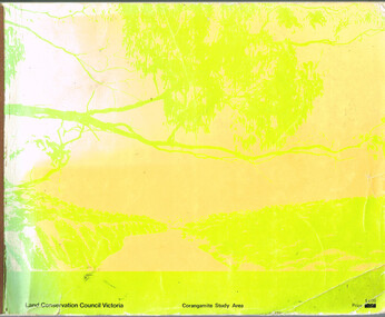
Book, Land Conservation Council, Report on the Corangamite Study Area, May 1976
... Otway Districts Historical Society Cliff Young Drive Beech Forest great-ocean-road The Report describes and assesses the natural resources of public land in the Corangamite study area, and provides a factual basis on which members of the community may base their submissions to the Council. Land Conservation Council; Corangamite; geology; physiography; climate; water resources; soils; vegetation; fauna; Report on the Corangamite study area. ...The Report describes and assesses the natural resources of public land in the Corangamite study area, and provides a factual basis on which members of the community may base their submissions to the Council.Report on the Corangamite study area. Land Conservation Council. Melbourne; Land Conservation Council; May 1976. x, 310 p.; illus, maps (separate). Soft cover.land conservation council; corangamite; geology; physiography; climate; water resources; soils; vegetation; fauna; -
 Bendigo Historical Society Inc.
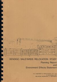
Book - BENDIGO SALEYARDS COLLECTION: BENDIGO SALEYARDS RELOCATION STUDY - PLANNING REPORT AND ENVIRONMENT
... Soil Investigation, C - Acoustic Assessment and D - Suggested Draft Amendment to Shire of Marong I.D.O. Contains a photo of the area - View of the Site, looking South and a number of drawings. Copies of various Council Reports referring to the Saleyards Relocation Project. It has a bright yellow cover and a hard plastic type spine. Mentioned in the reports is the cost to bring the old saleyards up to standard and list of improvements. Reports are as at 16th July, 1984. Mustard coloured book with plastic spine titled Bendigo Saleyards Relocation Study...Soil Investigation, C - Acoustic Assessment and D - Suggested Draft Amendment to Shire of Marong I.D.O. Contains a photo of the area - View of the Site, looking South and a number of drawings. Copies of various Council Reports referring to the Saleyards Relocation Project. It has a bright yellow cover and a hard plastic type spine. Mentioned in the reports is the cost to bring the old saleyards up to standard and list of improvements. Reports are as at 16th July, 1984. Mustard coloured book with plastic spine titled Bendigo Saleyards Relocation Study ...Bendigo Saleyards Relocation Study - Planning Report and Environment Effects Statement for the City of Bendigo by A E Huefner & Associates Pty Ltd in association with Meldrum Burrows & Partners. Book has a light brown cover with black plastic binder spine. Green and yellow pages separate some sections. The front cover has a sketch of a stock transport with a pig, sheep and cattle behind gates. Contents include: Introduction, Summary, Recapitulation on the Feasibility Report which includes The Need for Action, the Site and Existing Uses Adjacent to the Site, The Proposal which includes Concept, Project Description, Components, Siting of Facilities, Land Clearing, Earthworks, Darainage, Buildings and Structures, Roads and Pavements, Services, Landscaping, Soil Profile and Construction Programme. Invironmental Effects which include Visual Impact Dust, Odours, Effluent, Effluent Treatment System, Traffic, Artificial Lighting, Noise, Operational Failures and Nature Conservation Effects. Statutory Planning Considerations which includes Zoning Controls and Suggested Procedure for Initiating I.D.O. Amendment. Appendices are: A.- Copy of Tit;e, B - Soil Investigation, C - Acoustic Assessment and D - Suggested Draft Amendment to Shire of Marong I.D.O. Contains a photo of the area - View of the Site, looking South and a number of drawings. Copies of various Council Reports referring to the Saleyards Relocation Project. It has a bright yellow cover and a hard plastic type spine. Mentioned in the reports is the cost to bring the old saleyards up to standard and list of improvements. Reports are as at 16th July, 1984. Mustard coloured book with plastic spine titled Bendigo Saleyards Relocation Study Feasibility Report by Meldrum Burrows & Partners in association with A E Huefner & Associates Pty Ltd and Acil Australia Pty Ltd dated September, 1983. Items mentioned are: Introduction, Summary, Background, Role in Livestock Marketing for the Bendigo Saleyards (Acil Australia Pty. Ltd., Saleyard Relocation: Strategic Considerations, Financial Implications and Conclusion. Appendix 1: Estimation of Livestock Population in Catchment Area. Drawings in Fig 1 Existing Bendigo Saleyards and Surrounding Land Uses, Fig 2 Catchment Area for Bendigo Saleyards 1983, Fig 4.1 Estimated Sheep Populatiuon in Catchment Area 1976 - 77 to 1981 - 82, Fig 4.2 Estimated Cattle Population in Catchment area 1976 -77 to 1981 -82, Fig 3 Possible Saleyard Relocation Areas, Fig 4, Directions from which access to possible Saleyard Locations would be obtained - Estimated percentage of sheep to cattle stock, Fig 5 Possible Saleyard Locations - Northern Area, Fig 6 Possible Locations of Saleyards - Inner West, Fig 7 Possible Locations of Saleyards - Outer West. Considerations were made as to renovate the existing saleyards or to move them elsewhere. Effluent, transport and stock movement, and condition of the yards were a problem.bendigo, council, cattle markets, bendigo saleyards collection - bendigo saleyards relocation study - planning report and environment effects statement, a e huefner & associates pty ltd, meldrum burrows & partners, city of bendigo, state electricity commission, mal styles, bendigo college of advanced education, n j fieldew, pryce goodale & duncan pty ltd, p b swift, shire of marong -
Save the Dandenongs League Inc.
Archive (item), Save the Dandenongs League Incorporated, Upper Yarra Valley and Dandenong Ranges Land Management and Stream Environments Study - Volume 3: A Study of the Land - Soil Conservation Authority
... Upper Yarra Valley and Dandenong Ranges Land Management and Stream Environments Study - Volume 3: A Study of the Land - Soil Conservation Authority...Upper Yarra Valley and Dandenong Ranges Land Management and Stream Environments Study - Volume 3: A Study of the Land - Soil Conservation Authority Archive Save the Dandenongs League Incorporated ... -
 National Vietnam Veterans Museum (NVVM)
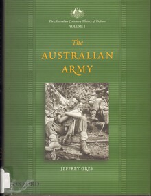
Book, Grey, Jeffrey, The Australian Army, Volume 1, 2001
... soil. This book is a history of the Australian Army as an institution. It is not a history of the Army's battles, nor is it a study of the Australian soldier or general - it is the history of the Australian Army with its shortcomings and failures paid due attention, its triumphs and successes duly noted. ...This is the first volume of The Australian Centenary History of Defence series. The Australian Army is the oldest of the three armed services, and is one of the oldest continuous national organisations in the country. It has fought in many of the twentieth century's major and minor conflicts, but has never engaged in battle on Australian soil. This book is a history of the Australian Army as an institution. It is not a history of the Army's battles, nor is it a study of the Australian soldier or general - it is the history of the Australian Army with its shortcomings and failures paid due attention, its triumphs and successes duly noted.This is the first volume of The Australian Centenary History of Defence series. The Australian Army is the oldest of the three armed services, and is one of the oldest continuous national organisations in the country. It has fought in many of the twentieth century's major and minor conflicts, but has never engaged in battle on Australian soil. This book is a history of the Australian Army as an institution. It is not a history of the Army's battles, nor is it a study of the Australian soldier or general - it is the history of the Australian Army with its shortcomings and failures paid due attention, its triumphs and successes duly noted. australia - armed forces - history, australia. royal australian air force -- history -
 Hume City Civic Collection
Photograph, early 1990's
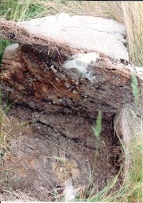
... The photographs were included in a study of these sites which was published by the Shire of Bulla in the early 1990's. aboriginal ring sites george evans collection A soil profile showing a whitened lava flow above decomposing timber and soil at the lower level. ...The set of 20 photographs were taken of a number of archaeological sites in Sunbury of sacred sites and aboriginal rings. The photographs were included in a study of these sites which was published by the Shire of Bulla in the early 1990's.A soil profile showing a whitened lava flow above decomposing timber and soil at the lower level.aboriginal ring sites, george evans collection -
University of Melbourne, Burnley Campus Archives
Document, Soils and Growing Media, 1988
... University of Melbourne, Burnley Campus Archives 500 Yarra Boulevard Richmond melbourne ivo dean soils growing media Study guide by Ivo Dean, 44 pp. Soils and Growing Media Document ...Study guide by Ivo Dean, 44 pp. ivo dean, soils, growing media -
Villa Alba Museum
Document, Villa Alba Museum Archaeological Test Excavations, 2002
... studies Conservation reports archaeological reports villa alba museum A preliminary report on archaeological test excavations, conducted on 5 & 7 September 2002 by Maddy Atkinson (Ripple Arc). The purpose of the excavations was twofold. Firstly, to conduct subsurface testing at Villa Alba to determine the presence, location and depth below ground of archaeological remains relating to a number of landscape features identified in historical plans, photographs, survey field books and aerial photographs. Secondly, soils ...A preliminary report on archaeological test excavations, conducted on 5 & 7 September 2002 by Maddy Atkinson (Ripple Arc). The purpose of the excavations was twofold. Firstly, to conduct subsurface testing at Villa Alba to determine the presence, location and depth below ground of archaeological remains relating to a number of landscape features identified in historical plans, photographs, survey field books and aerial photographs. Secondly, soils surrounding the Villa Alba mansion, which have been found to be contaminated with lead will need to be removed up to a depth of up to 0.6 metres. Removal of deposits from the site may have an adverse impact on any archaeological remains existing below the surface.Contents: Acknowledgements / Abbreviations / List of figures / List of tables / List of plates / Introduction / Historical context / Methodology / Results and interpretations / Discussion / Recommendations / References / Appendix 1 - Plates / Appendix 2 - Content list / Appendix 3 - Copy of Heritage Victoria permit.non-fictionA preliminary report on archaeological test excavations, conducted on 5 & 7 September 2002 by Maddy Atkinson (Ripple Arc). The purpose of the excavations was twofold. Firstly, to conduct subsurface testing at Villa Alba to determine the presence, location and depth below ground of archaeological remains relating to a number of landscape features identified in historical plans, photographs, survey field books and aerial photographs. Secondly, soils surrounding the Villa Alba mansion, which have been found to be contaminated with lead will need to be removed up to a depth of up to 0.6 metres. Removal of deposits from the site may have an adverse impact on any archaeological remains existing below the surface. conservation studies, conservation reports, archaeological reports, villa alba museum -
 University of Melbourne, Burnley Campus Archives
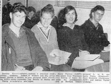
Newspaper - Newspaper Cutting, The Sunraysia Daily, Studying the Land, 1964
... Photograph in "The Sunraysia Daily" May 27, 1964. 4 Burnley students who are part of a group of 30 students who are making a practical study of Mildura. They are attending an ADFA lecture on Mallee soil types. ...University of Melbourne, Burnley Campus Archives 500 Yarra Boulevard Richmond melbourne sunraysia daily students mildura kerry flattey lucia pruiss mary monteith adrian taylor adfa lecture sojourns excursions Photograph in "The Sunraysia Daily" May 27, 1964. 4 Burnley students who are part of a group of 30 students who are making a practical study of Mildura. They are attending an ADFA lecture on Mallee soil types. ...Photograph in "The Sunraysia Daily" May 27, 1964. 4 Burnley students who are part of a group of 30 students who are making a practical study of Mildura. They are attending an ADFA lecture on Mallee soil types. They are: Kerry Flattley, Lucia Pruis(s) (sic), Mary Monteith and Adrian Taylor (all 1966).sunraysia daily, students, mildura, kerry flattey, lucia pruiss, mary monteith, adrian taylor, adfa lecture, sojourns, excursions -
University of Melbourne, Burnley Campus Archives
Booklet - Handbook, Rod McMillan, A Student Handbook for Further Study of Soils and Growing Media, 1993
... University of Melbourne, Burnley Campus Archives 500 Yarra Boulevard Richmond melbourne horticulture soil media rod mcmillan Display copy (Bookshop) for the Advanced Certificate in Horticulture by Rod McMillan A Student Handbook for Further Study of Soils and Growing Media Booklet Handbook Found Rod McMillan ...horticulture, soil, media, rod mcmillan -
University of Melbourne, Burnley Campus Archives
Booklet, Michele Adler, Studies in Horticulture, 1998-2007
... Soil characteristics,' by Rod McMillan. 1998. 10. 'Landscape drawing and graphics: (1) Developing graphic skills,' by Ken Wallace revised by Scott Watson. 2000. 11. 'Observe environmental work practices,' by Ron Barrow. 2005. 12. 'Operate tractors & operate equipment & machinery,' by Ken James. 2003. 13. 'Provide workside support & maintain the work environment,' by Peter Sheppard & Rod McMillan. 2001. 14. 'Implement a promotional program,' by John Stanley. 2000. 15. Follow OH & S procedures,' by Ron Barrow. 2005 Studies ...Royalties from the sale of booklets donated to the Friends of Burnley GardensPlants in Print price labels on some of them. Display Copy Not for Sale on some of them.studies in horticulture, horticulture, t.a.f.e., rod mcmillan, michele adler, plant recognition, workplace requirements, industry requirements, workplace communication, peter esdale, workplace maintenance, peter sheppard, teamwork, soil characteristics, lanscape drawing, graphics, ken wallace, scott watson, ron barrow, operate tractors, operate machinery, ken james, work environment, john stanley, promotional program, oh & s procedures -
Clunes Museum
Education kit - DOCUMENT, SOIL CONSERVATION AUTHORITY, MCHUGH'S GULLY - A LAND USE AND MANAGEMENT TEACHING RESOURCE KIT, 1982
... Clunes Museum 36 Fraser Street enter building through Collins Place Clunes goldfields Records effects of erosion at McHugh's Gully McHughs Gully LAND MANAGEMENT ENVIRONMENTAL IMPACT REPORT ENVIRONMENTAL STUDY OF MCHUGH'S GULLY RECORDED IN THE EARLY 1980'S SINGLE NOTE SEPARATE FROM PUBLICATION : HANDWRITTEN IN BLUE BIRO "from Primary School" BUFF COLOURED LEVER ARCH FILE CONTAINING SECTIONS A TO I WITH A CARDBOARD INSERT OF FRONT COVER WITH SEPIA IMAGES OF RURAL SCENES AND TOWN SHIP PRINTED ON IT. Section A contains documents of land use and management teaching resource kit. Section I contains slides and transparencies MCHUGH'S GULLY - A LAND USE AND MANAGEMENT TEACHING RESOURCE KIT Education kit DOCUMENT Chris Smyth SOIL ...ENVIRONMENTAL STUDY OF MCHUGH'S GULLY RECORDED IN THE EARLY 1980'SBUFF COLOURED LEVER ARCH FILE CONTAINING SECTIONS A TO I WITH A CARDBOARD INSERT OF FRONT COVER WITH SEPIA IMAGES OF RURAL SCENES AND TOWN SHIP PRINTED ON IT. Section A contains documents of land use and management teaching resource kit. Section I contains slides and transparenciesnon-fictionENVIRONMENTAL STUDY OF MCHUGH'S GULLY RECORDED IN THE EARLY 1980'Smchughs gully, land management, environmental impact report -
University of Melbourne, Burnley Campus Archives
Certificate - Award Certificate, Victorian College of Agriculture and Horticulture, Horticulture Studies, c. 1983-1996
... VCAH VICTORIAN COLLEGE OF AGRICULTURE and HORTICULTURE Horticultural Studies Certificate This is to certify that JANE DOUGLAS HERRING has successfully completed eight units each of thirty hours part-time study at the levels shown below PLANT FORM AND FUNCTION D SOILS AND GROWING MEDIA HP INTRODUCTION TO HORTICULTURE D WEEDS AND DISEASES HP PLANT REPRODUCTION D ORNAMENTAL HORTICULTURE D PLANT PROPAGATION HP PESTS AND PESTICIDES D Director.... ...Certificate for Jane Douglas Herring stating she had successfully completed part-time study in 8 units, but not dated or signed. jane douglas herring students VCAH Horticultural Studies Certificate VCAH Burnley VCAH VICTORIAN COLLEGE OF AGRICULTURE and HORTICULTURE Horticultural Studies Certificate This is to certify that JANE DOUGLAS HERRING has successfully completed eight units each of thirty hours part-time study at the levels shown below PLANT FORM AND FUNCTION D SOILS AND GROWING MEDIA HP INTRODUCTION TO HORTICULTURE D WEEDS AND DISEASES HP PLANT REPRODUCTION D ORNAMENTAL HORTICULTURE D PLANT PROPAGATION HP PESTS AND PESTICIDES D Director.... ...Certificate for Jane Douglas Herring stating she had successfully completed part-time study in 8 units, but not dated or signed.Original certificate awarded to Jane Douglas Herring - not signed by Principal.VCAH VICTORIAN COLLEGE OF AGRICULTURE and HORTICULTURE Horticultural Studies Certificate This is to certify that JANE DOUGLAS HERRING has successfully completed eight units each of thirty hours part-time study at the levels shown below PLANT FORM AND FUNCTION D SOILS AND GROWING MEDIA HP INTRODUCTION TO HORTICULTURE D WEEDS AND DISEASES HP PLANT REPRODUCTION D ORNAMENTAL HORTICULTURE D PLANT PROPAGATION HP PESTS AND PESTICIDES D Director.... Principal.... dated thisjane douglas herring, students, vcah, horticultural studies, certificate, vcah burnley