Showing 143 items matching "south channel"
-
 Flagstaff Hill Maritime Museum and Village
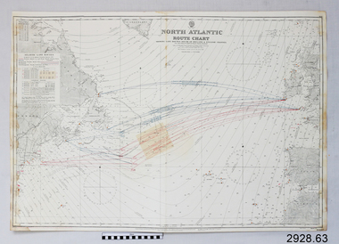
Document - Navigation Chart, North Atlantic : Route Chart showing Lane Routes South of Ireland & English Channel
... North Atlantic : Route Chart showing Lane Routes South of Ireland & English Channel...British Admiralty Navigation Chart - North Atlantic : Route Chart showing Lane Routes South of Ireland & English Channel...Flagstaff Hill Maritime Museum and Village 89 Merri Street Warrnambool great-ocean-road warrnambool shipwrecked-coast flagstaff-hill flagstaff-hill-maritime-museum maritime-museum shipwreck-coast flagstaff-hill-maritime-village shipwrecked-artefact navigation chart british admiralty navigation chart british admiralty north atlantic route chart north atlantic British Admiralty Navigation Chart - North Atlantic : Route Chart showing Lane Routes South of Ireland & English Channel North Atlantic : Route Chart showing Lane Routes South of Ireland & English Channel Document Navigation Chart ...British Admiralty Navigation Chart - North Atlantic : Route Chart showing Lane Routes South of Ireland & English Channelwarrnambool, shipwrecked-coast, flagstaff-hill, flagstaff-hill-maritime-museum, maritime-museum, shipwreck-coast, flagstaff-hill-maritime-village, shipwrecked-artefact, navigation chart, british admiralty navigation chart, british admiralty, north atlantic route chart, north atlantic -
 Geelong Naval and Maritime Museum
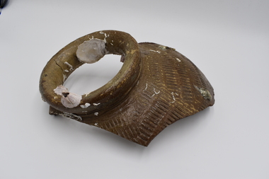
Ceramic - Pot Fragment
... ...south channel light...The fragments of pot were found in 20 meters of water off of the South Channel Light, Port Phillip Bay. They are believed to be from the ship 'Hurricane' that sank in the vicinity on April 22,1864. ...The wreck of the "Hurricane" in Port Phillip Bay and the accompanying story of the nearby lighthouse, the South Channel Pile Light, tell the story of early shipping within Port Phillip Bay, pre federation. shipwreck port phillip bay ship hurricane south channel light 3 pieces of encrusted pot fragment all roughly A5 paper size Ceramic Pot Fragment ...The fragments of pot were found in 20 meters of water off of the South Channel Light, Port Phillip Bay. They are believed to be from the ship 'Hurricane' that sank in the vicinity on April 22,1864. The Hurricane was a three-masted iron ship, weighing 1198/979 tons. Built on the Clyde, Scotland in 1853. Lbd 214.9 x 30.7 x 20 ft. It was one of the first large iron sailing ships built for the Australian trade during the gold rush, and one of the fastest clippers on the Australian run. Her maiden voyage from Glasgow to Melbourne with 256 passengers took eighty-seven days, and the return to London eighty-three days. In 1856 she was converted to an auxiliary screw vessel and continued in the Australian trade until lost. Under Captain D.H. Johnston (former master of the Lightning), inward bound from Liverpool with 2000 tons of general cargo and 19 passengers, grazed a rock entering Port Phillip, sank off Arthurs seat, 21 April 1869. Passengers and crew transferred to the tug Titan. The wreck was relatively intact until the late 1960s, when it was blasted by Ports and Harbours engineers who considered it to be a navigational hazard, spreading wreckage over a wide area. Despite this, the stern of the ship still stands about three metres above the sand. The wreck of the "Hurricane" in Port Phillip Bay and the accompanying story of the nearby lighthouse, the South Channel Pile Light, tell the story of early shipping within Port Phillip Bay, pre federation. 3 pieces of encrusted pot fragment all roughly A5 paper sizeshipwreck, port phillip bay, ship hurricane, south channel light -
 Lakes Entrance Historical Society
Map - Lakes Entrance Survey Map 1892-1895, 1895
... Survey map showing Rigby Island, Bullock Island, Snake Island, South Channel, Mt Barkley Kalimna...Lakes Entrance Historical Society 4 Marine Parade Lakes Entrance gippsland Islands Waterways Townships Survey map showing Rigby Island, Bullock Island, Snake Island, South Channel, Mt Barkley Kalimna Map Lakes Entrance Survey Map 1892-1895 ...Survey map showing Rigby Island, Bullock Island, Snake Island, South Channel, Mt Barkley Kalimnaislands, waterways, townships -
 Queenscliffe Maritime Museum
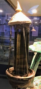
Equipment - Sun valve
... ...South Channel...Relic from the Hovell light run on acetylene from 1925 to 1985 Hovell Pile Light South Channel Port Phillip Sun valve from the Hovell Pile Light Equipment Sun valve ...The light was powered by a kerosene lantern that had to be kept alight by the keepers until the introduction of bottled acetylene gas in 1925. The light operated for 111 years until 1985 when it was turned off for a trial period. It was never turned back on. A sun valve is a flow control activated by sunlight heat which automatically shuts off gas during daylight hours. Relic from the Hovell light run on acetylene from 1925 to 1985Sun valve from the Hovell Pile Lighthovell pile light, south channel, port phillip -
 Federation University Historical Collection
Photograph - Photograph - Black and White, Aerial Photograph of the Ballarat School of Mines and Ballarat East, Pre 1967
... south...yarrowee channel...Barker Library (top floor) Mount Helen goldfields ballarat gaol white flat ballarat uniting church ballarat girls' technical school armstrong street south lydiard street south yarrowee channel humffray street south m.b. john john valves former ballarat gaol ballarat brewery dana street grant street lydiards street south white flat oval aerial photograph Black and white aerial photograph of the Ballarat School of Mines, White Flat Oval, Ballarat Gaol, Ballarat Brewery, Ballarat Club, Uniting Church, John Valves (Lydiard Street), Ballarat Girls' Technical School and Ballarat Aerial Photograph of the Ballarat School of Mines and Ballarat East Photograph Photograph - Black and White ...Black and white aerial photograph of the Ballarat School of Mines, White Flat Oval, Ballarat Gaol, Ballarat Brewery, Ballarat Club, Uniting Church, John Valves (Lydiard Street), Ballarat Girls' Technical School and Ballarat ballarat gaol, white flat, ballarat uniting church, ballarat girls' technical school, armstrong street south, lydiard street south, yarrowee channel, humffray street south, m.b. john, john valves, former ballarat gaol, ballarat brewery, dana street, grant street, lydiards street south, white flat oval, aerial photograph -
 Queenscliffe Maritime Museum
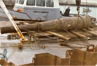
Photograph - Colour photo, 1980, of "disappearing gun" during transportation, Disappearing 12" Gun, 1980
... Disappearing gun relocated to Queenscliffe Fort from South Channel Fort 1980...Queenscliffe Maritime Museum 2 Wharf St Queenscliff geelong-and-the-bellarine-peninsula Disappearing gun relocated to Queenscliffe Fort from South Channel Fort 1980 Disappearing gun barrel being transported. historical references Reverse - " nil " Black & white 1908 photograph of Queenscliffe fishermen's catch on the pier Disappearing 12" Gun Photograph Colour photo, 1980, of "disappearing gun" during transportation. ...Disappearing gun relocated to Queenscliffe Fort from South Channel Fort 1980Disappearing gun barrel being transported.Black & white 1908 photograph of Queenscliffe fishermen's catch on the pierReverse - " nil "historical references -
 Queenscliffe Maritime Museum
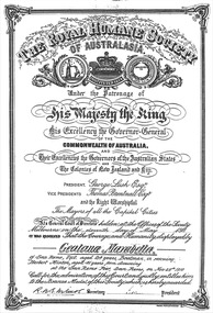
Certificate - Illuminated Address & Certification, Royal Humane Society certificate/citation for Geatana Marabella, dated 11 May 1911, 11 May 1911
... Disappearing gun relocated to Queenscliffe Fort from South Channel Fort 1980...Queenscliffe Maritime Museum 2 Wharf St Queenscliff geelong-and-the-bellarine-peninsula Disappearing gun relocated to Queenscliffe Fort from South Channel Fort 1980 Disappearing gun barrel being transported. historical references Reverse - " nil " Royal Humane Society Citation of 11 May 1911 for Geatana Marabella for 'courage & humanity' Royal Humane Society certificate/citation for Geatana Marabella, dated 11 May 1911. ...Disappearing gun relocated to Queenscliffe Fort from South Channel Fort 1980Disappearing gun barrel being transported.Royal Humane Society Citation of 11 May 1911 for Geatana Marabella for 'courage & humanity'Reverse - " nil "historical references -
![Rear [inside] view of a brass lock with key from the Port and Harbours suction dredge 'Pioneer' used at the Queenscliff creek entrance](/media/collectors/4f729f7e97f83e03086018d1/items/5f855cde425f7f235017d662/item-media/612dad24e8448ba3f69e3419/item-fit-380x285.jpg?cb=6) Queenscliffe Maritime Museum
Queenscliffe Maritime MuseumFunctional object - Lock, door, brass
... . - After a series of successful experiments in dredging the eastern end of the South Channel, the suction dredge Pioneer sailed this after-noon for the Gippsland Lakes, where work awaits her. .... - After a series of successful experiments in dredging the eastern end of the South Channel, the suction dredge Pioneer sailed this after-noon for the Gippsland Lakes, where work awaits her. ...The Argus Melbourne Friday 10 July 1908 QUEENSCLIFF, Thursday. - After a series of successful experiments in dredging the eastern end of the South Channel, the suction dredge Pioneer sailed this after-noon for the Gippsland Lakes, where work awaits her. During operations in the South Channel the dredge worked on a sandy and shell bottom in depths ranging from 35ft. to 40ft. with unqualified success, performing the work much quicker and cheaper than the bucket drudge John Nimmo, which is still employed. Captain Macarthur was in charge of the operations.Brass lock from Port and Harbours suction dredge 'Pioneer' used at the Queenscliff creek entrance door lock, suction dredge, pioneer -
 Queenscliffe Maritime Museum
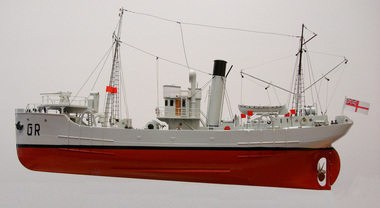
Leisure object - Model Ship, HMAS Goorangai
... The H M A S Goorangai was struck by the M V 'Duntroon' on the night of 20/11/1940 in the South Channel of Port Phillip Bay. All 24 crew members of the Goorangai were lost....Queenscliffe Maritime Museum 2 Wharf St Queenscliff geelong-and-the-bellarine-peninsula The H M A S Goorangai was struck by the M V 'Duntroon' on the night of 20/11/1940 in the South Channel of Port Phillip Bay. All 24 crew members of the Goorangai were lost. duntroon port phillip bay ship models G R Model of 'Goorangai" HMAS Goorangai Leisure object Model Ship ...The H M A S Goorangai was struck by the M V 'Duntroon' on the night of 20/11/1940 in the South Channel of Port Phillip Bay. All 24 crew members of the Goorangai were lost.Model of 'Goorangai" G Rduntroon, port phillip bay, ship models -
 Melbourne Tram Museum
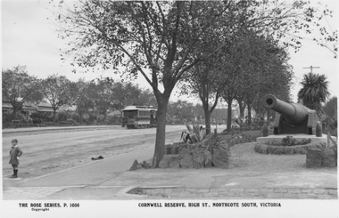
Postcard - Cornwell Reserve, High Street, Northcote South, Rose Stereograph Co, 1913-1920s
... The cannons were originally built in England in 1884/8 5 and installed in Melbourne's South Channel Fort off Sorrento to defend against possible Russian invasion. ...The cannons were originally built in England in 1884/8 5 and installed in Melbourne's South Channel Fort off Sorrento to defend against possible Russian invasion. ...Photograph looks north along High Street from corner of Urquhart Street with a Northcote line cable tram travelling northward. The large cannon is one of two located at southern end of High Street in June 1913 by the Northcote South Ratepayer’s Association. The cannons were originally built in England in 1884/8 5 and installed in Melbourne's South Channel Fort off Sorrento to defend against possible Russian invasion. Cornwell Reserve is now known as High Street Linear Reserve. Rose postcard 1056.Yields information about High Street Northcote South Postcard with label below photograph and postcard markings on rear. On front: 'The Rose Series P 1056 Cornwell Reserve, High Street, Northcote South'; on rear: 'Postcard - A real photograph Produced in Australia'northcote, cable tram, cornwell reserve, high street linear reserve., high st, urquhart st, rose series -
 Sunshine and District Historical Society Incorporated
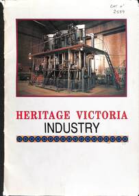
Book - Heritage Victoria Industry, National Trust of Australia, 1990
... Heritage Victoria Industry|McKay - Massey Ferguson Site|Avoca Powder Magazine|State Bank Williamstown|Pipemaker's Park|Beechworth Town|Rushworth Chronicle|Powelltown Saw Mill Sites|South Channel Fort|Victoria Brewery|Walkerville Lime Kilns|Williamstown Time Ball Tower and Tide Gauge|Wonthaggi Coal Mine|Mount Difficult Quarry Heatherlie|LaL Lal Blast Furnace|Geelong Telegraph Station|J. ...Heritage Victoria Industry|McKay - Massey Ferguson Site|Avoca Powder Magazine|State Bank Williamstown|Pipemaker's Park|Beechworth Town|Rushworth Chronicle|Powelltown Saw Mill Sites|South Channel Fort|Victoria Brewery|Walkerville Lime Kilns|Williamstown Time Ball Tower and Tide Gauge|Wonthaggi Coal Mine|Mount Difficult Quarry Heatherlie|LaL Lal Blast Furnace|Geelong Telegraph Station|J. ...Collection of information sheets on industries in Victoria -
 Queenscliffe Maritime Museum
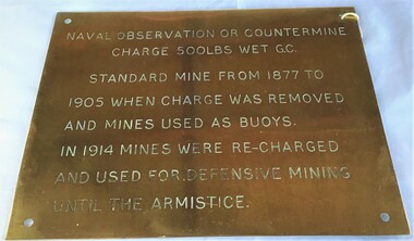
Plaque - Plaque, brass inscribed with Naval countermine information
... The scheme, involving massive expenditure, comprised a forward defence system of forts at Port Phillip heads dominated by Fort Queenscliff and South Channel Fort (artificial island), and a network of coastal batteries. ...The scheme, involving massive expenditure, comprised a forward defence system of forts at Port Phillip heads dominated by Fort Queenscliff and South Channel Fort (artificial island), and a network of coastal batteries. ...Found in garden shed of Mr Harry Barratt [WWI Gallipoli] and donated by his grandson. In 1877 Swan island was designed to defend shipping in Port Phillip and Hobson's Bays. The scheme, involving massive expenditure, comprised a forward defence system of forts at Port Phillip heads dominated by Fort Queenscliff and South Channel Fort (artificial island), and a network of coastal batteries. Some development of fortification had occurred in the 1850s, but it was the impetus of the Jervois-Scratchley reports which led to major work being undertaken in the 1880s. The overall defence plan involved a combination of guns, mines (known as electric torpedo) and ships to defend the entrance to Port Phillip Bay. Swan Island Fort would be used to protect the minefields in the harbour, Naval observation countermine charge 500lbs wet G.C Standard mine from 1877 to 1905 when charge was removed and mines used as buoys. In 1914 mines were recharged and used for defensive mining until Armistice.Brass plaque inscribed with information on naval countermineNaval observation or countermine charge 500lbs wet G.C. Standard mine from 1877 to 1905 when charge was removed and mines used as buoys. In 1914 mines were recharged and used for defensive mining until the Armistice.sea mine, plaque, pre wwi, naval countermine, swan island -
 Queenscliffe Maritime Museum
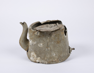
Domestic object - Teapot
... At around 20:30 on the 20th of November 1940 the 10,400-ton MV Duntroon was transiting the South Channel on her way to Sydney from Perth via Melbourne carrying 65 passengers and general and perishable cargo. ...At around 20:30 on the 20th of November 1940 the 10,400-ton MV Duntroon was transiting the South Channel on her way to Sydney from Perth via Melbourne carrying 65 passengers and general and perishable cargo. ...In 1940, German minefields were laid in east and west Bass Strait which quickly claimed merchant ships Cambridge (British) and the City of Rayville (American). HMAS Goorangai had finished mine sweeping duties and after resupply was crossing from Queenscliff to Point Nepean to seek better anchorage due to impending bad weather. At around 20:30 on the 20th of November 1940 the 10,400-ton MV Duntroon was transiting the South Channel on her way to Sydney from Perth via Melbourne carrying 65 passengers and general and perishable cargo. It struck HMAS Goorangai forward of the funnel on the port side and cut her in two. At about 20:45 HMAS Goorangai sank in less than a minute resulting in the loss of her whole ship’s company, a complement of 24 officers and sailors.HMAS Goorangai was the first Royal Australian Navy (RAN) ship lost in WWII, the first RAN surface ship lost in wartime, and the first RAN surface ship lost with all hands. A memorial cairn was erected at Queenscliff in 1981 and a service of commemoration is held there every year.A severely damaged and corroded aluminium teapot recovered from the wreck of HMAS Goorangaihmas goorangai, wwii, collision at sea -
 Bendigo Military Museum
Map - RASvy " Map Makers Exhibition 2025 "- Map display, RAN Hydrographic Office, 1972 - 1992
... PORT PHILLIP SOUTH and WEST CHANNELS. PROJECTION TRANSVERSE MERCATOR. ...Current as at 30 Jun 92. .2 Extract of Navigational Plotting Chart " NP22-2 Tasmania " .3 Extract of Navigational Plotting Chart " NP 27 RAAF PLOTTING CHART AUSTRALIA - SOUTHEAST " .4 Extract of Navigational Plotting Chart " RAAF LONG RANGE PLOTTING CHART NP43-4 AUSTRALIA WESTERN " .5 Extract of Navigational Plotting Chart " RAAF LONG RANGE PLOTTING CHART NP43-7 SOLOMON ISLANDS " .6 Extract of Navigational Series " RAAF AIR STAFF PLANNING CHART NS 137-2 DARWIN NORTH WEST " .7 Extract of Navigational Series " RAAF AIR STAFF PLANNING CHART NS 137-1 DARWIN NORTH EAST " .8 Extract of Navigational Series " RAAF AIR STAFF PLANNING CHART NS 137-4 DARWIN SOUTH WEST " .9 Extract of Navigational Series " RAAF AIR STAFF PLANNING CHART NS 137-3 DARWIN SOUTH EAST " .10 Extract of Tactical Pilotage Chart " TPC R-13B " .11 Extract of Hydrographic Chart " PORT PHILLIP SOUTH and WEST CHANNELS " .12 Extract of Hydrographic Chart " GEELONG HARBOUR and APPROACHES " .13 Extract of En Route Chart " AUSTRALIA ERC HIGH " " H1 and H2 " ...PORT PHILLIP SOUTH and WEST CHANNELS. PROJECTION TRANSVERSE MERCATOR. ...All of these Charts / Maps were used for the RSL Museum display " The Mapmakers " ( of RASvy. ) 10 Jun - 10 Aug 2025. .1 Catalogue of Tactical Pilotage Charts, 1:500 000 Scale. Digital Data Base available as at 30Jun 92. This catalogue page shows the extent of the Australian area of responsibility for aeronautical charting. .2 RAAF PLOTTING CHART. NP 22-2 (Navigational Plotting) Tasmania. MERCATOR PROJECTION. This series of charts were used for the training of RAAF Navigators. These charts were produced and printed at the Army Survey Regiment, Bendigo. .3 RAAF PLOTTING CHART AUSTRALIA - SOUTHEAST. NP 27 is Based on LAMBERT CONFORMAL CONIC PROJECTION. This series of charts was used by RAAF Navigators for the planning of RAAF flights. These charts were produced and printed at the Army Survey Regiment, Bendigo. .4 RAAF LONG RANGE PLOTTING CHART. NP 43-4 AUSTRALIA WESTERN. MERCATOR PROJECTION. This series of maps were used for the planning of RAAF flights. Of Particular note these charts were used to plot "Rhumb Lines or loxodromes" where a course crosses all Meridians (Lines of latitude and longitude) at the same angle. On Mercator projection charts Rhumb lines are conveniently shown as straight lines and are also lines of constant compass bearing. Rhumb lines are usually longer than the shortest distance between two points. The shortest distance between two points on the earth's surface is called a "Great Circle Route" which is a route on a circular path on the surface of the earth where the centre of that circle is also the centre of the earth. Great Circle Routes on a Mercator Projection are however curves and harder to plot. These charts were produced and printed at the Army Survey Regiment, Bendigo. .5 RAAF LONG RANGE PLOTTING CHART. NP 43-7 SOLOMON ISLANDS. MERCATOR PROJECTION. Used for the planning of RAAF flights. .6 RAAF AIR STAFF PLANNING CHART NS 137-1 DARWIN NORTH WEST. AZIMUTHAL EQUIDISTANT PROJECTION. This series of charts were used for planning by the staff. The whole chart was produced by joining the four quadrant maps together. The charts are based on a single point of tangency (in this case Darwin) and shows radius (distance) in nautical miles to and from that point. A series of charts were produced centred on each of the major airfields in Northern Australia. These charts were produced and printed at the Army Survey Regiment, Bendigo. .7 RAAF AIR STAFF PLANNING CHART NS 137-2 DARWIN NORTH EAST. AZIMUTHAL EQUIDISTANT PROJECTION. Used for the planning by the staff. The charts are based on a point of tangency and show radius in nautical miles. .8 RAAF AIR STAFF PLANNING CHART NS 137-4 DARWIN SOUTH WEST. AZIMUTHAL EQUIDISTANT PROJECTION. Used for the planning by the staff. The charts are based on a point of tangency and show radius in nautical miles. .9 RAAF AIR STAFF PLANNING CHART NS 137-3 DARWIN SOUTH EAST. AZIMUTHAL EQUIDISTANT PROJECTION. Used for the planning by the staff. The charts are based on a point of tangency and show radius in nautical miles. .10 TACTICAL PILOTAGE CHART. TPC R-13B. LAMBERT CONFORMAL PROJECTION. Used by pilots for flight planning and could be used in flight if necessary for visual navigation using major ground features shown on the chart. These charts also contained aeronautical information such as airfields, radio navigation beacons and obstructions. Contours and height information was shown in feet to be compatible with aircraft altimeters. Each graticule square also contained a Maximum Safe Elevation Figure (MEF) also in feet. Coverage of this series over Australia's area of interest were produced and printed at the Army Survey Regiment, Bendigo. .11 HYDROGRAPHIC CHART. AUS 158. PORT PHILLIP SOUTH and WEST CHANNELS. PROJECTION TRANSVERSE MERCATOR. Used by all people needing to navigate a vessel. Hydrographic charts were printed at the Army Survey Regiment, Bendigo. .12 HYDROGRAPHIC CHART. AUS 157. GEELONG HARBOUR and APPROACHES. PROJECTION TRANSVERSE MERCATOR. Used by all people needing to navigate a vessel. .13 EN ROUTE CHART. AUSTRALIA ERC HIGH. H1 and H2. LAMBERT CONFORMAL CONIC PROJECTION. This series of charts were regularly produced by the RAAF Aeronautical Information Service (AIS) and contained current aeronautical information for pilots. These charts were printed at the Army Survey Regiment, Bendigo..1 Tactical Pilotage Chart Series Catalogue. Current as at 30 Jun 92. .2 Extract of Navigational Plotting Chart " NP22-2 Tasmania " .3 Extract of Navigational Plotting Chart " NP 27 RAAF PLOTTING CHART AUSTRALIA - SOUTHEAST " .4 Extract of Navigational Plotting Chart " RAAF LONG RANGE PLOTTING CHART NP43-4 AUSTRALIA WESTERN " .5 Extract of Navigational Plotting Chart " RAAF LONG RANGE PLOTTING CHART NP43-7 SOLOMON ISLANDS " .6 Extract of Navigational Series " RAAF AIR STAFF PLANNING CHART NS 137-2 DARWIN NORTH WEST " .7 Extract of Navigational Series " RAAF AIR STAFF PLANNING CHART NS 137-1 DARWIN NORTH EAST " .8 Extract of Navigational Series " RAAF AIR STAFF PLANNING CHART NS 137-4 DARWIN SOUTH WEST " .9 Extract of Navigational Series " RAAF AIR STAFF PLANNING CHART NS 137-3 DARWIN SOUTH EAST " .10 Extract of Tactical Pilotage Chart " TPC R-13B " .11 Extract of Hydrographic Chart " PORT PHILLIP SOUTH and WEST CHANNELS " .12 Extract of Hydrographic Chart " GEELONG HARBOUR and APPROACHES " .13 Extract of En Route Chart " AUSTRALIA ERC HIGH " " H1 and H2 " royal australian survey corps, rasvy, fortuna, detachment - army survey regiment, army svy regt, asr -
 Flagstaff Hill Maritime Museum and Village
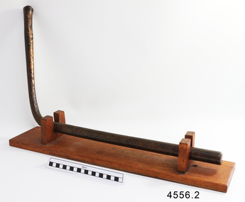
Nail, circa 1810
... Nearing the end of their journey on 10th April 1835 the “George III” was headed through the D'Entrecasteaux Channel, south east Tasmania, between the mainland and Bruny Island. ...Nearing the end of their journey on 10th April 1835 the “George III” was headed through the D'Entrecasteaux Channel, south east Tasmania, between the mainland and Bruny Island. ...This copper nail, sometimes known as a ‘Dumpy Bolt’ or spike, was salvaged from the hull of the wreck of the “George III”. It dates back to at least 1810. It was found by an abalone diver on the south east coast of Tasmania. The nail would have been used to hold the layers of the ship’s keel frame and the planking together. The nail has been passed from the abalone diver to an interested business man on a trip to the south of Hobart, on again to the business man’s close friend who then donated it to Flagstaff Hill Maritime Village. The metal of nails such as this one, after being in the sea for a long time, become affected by the natural reaction of the sea water, causing it to degenerate and thin, and the stress from the force of the sea over the years alters its shape. Iron nails had been used on ships previously, but they quickly corroded in the salt; ships needed regular, costly and time-consuming maintenance to replace the iron nails. Towards the end of the 18th century the British Navy trialled the use of copper nails, finding them to be very successful. Merchant ships began to adopt this process in the early 19th century, although it made ship building very expensive and was more often used for ships such as the “George III” that sailed on long voyages. The three masted sailing ship “George III” was a convict transport ship built in Deptford, England, in 1810. On 14th December 1834 she left Woolwich, England, bound for Hobart Town, Van Diemen’s Land (Tasmania), under Captain William Hall Moxey. She was carrying 220 male convicts plus crew, guards and their families, totalling 294 persons (another 2 were during the voyage). Amongst the cargo were military stores including several copper drums of gun powder. On 27th January 1835 the “George III” was near the Equator, about half way into her journey. A fire broke out and the gun powder was in danger of explosion, threatening the whole ship. Two convicts braved the heat and smoke, entered the store and seized the gun powder drums, suffering burns for their efforts but saving a probable disaster. The fire destroyed some of the provisions and food was scarce. Many became ill with scurvy and some died during the journey. Nearing the end of their journey on 10th April 1835 the “George III” was headed through the D'Entrecasteaux Channel, south east Tasmania, between the mainland and Bruny Island. She was sailing in the moonlit night to hasten her arrival in port due to the great number of sick on board. She struck uncharted rocks, known only to the local whalers, between Actaeon Reef and Southport Lagoon and within hours began to break up. The ship’s boats were used to first rescue the women and children. Firearms were used to help quell the panic of the convicts below decks and some were killed by the shots. Many convicts, including the sick, were drowned. In all, 133 lives were lost including 5 of the crew, guards and their families. It was the third worst shipping disaster in Tasmanian waters. A monument in honour of the prisoners who perished in the “George III” has been erected, noting the date of the wreck as “Friday 10th April 1835.” (NOTE: there are a few differences between sources regarding dates of the shipwreck, some saying March and others April 1835. There are also differences in the figures of those on board and the number of lives lost.) The copper nail is significant as an example of sailing ship construction; fasteners used in the early 19th century on ships carrying convicts to Australia. The nail is also significant for its association with the ship “George III”. The “George III” is registered on the Australian National Shipwreck Database, ID 7195 as an Historic Shipwreck. She is the third worst shipwreck in Tasmanian waters. She is also associated with Early Australian History and the transportation of convicts to Australia. The incident of the fire on board and the bravery of the convicts in making the gun powder safe is an example of the social character of the people in early Tasmanian colonisation. Copper nail (also called a Dumpy bolt or spike) from the convict ship George III, wrecked in 1835. Nail is long, bent in an ‘L’ shape about 3/5ths along, tapering from both ends to the bend. Both ends are flat and do not taper to a point, nor have a thread. The shorter end has been polished, showing bright copper. There is pitting along the nail and virdigris is evident on the longer, unpolished end. The nail is displayed with the longer section resting on a wooden board between two ‘U’ shaped uprights, the shorter section upright. flagstaff hill, warrnambool, shipwrecked coast, flagstaff hill maritime museum, maritime museum, shipwreck coast, flagstaff hill maritime village, great ocean road, george iii, ship construction, ship nail, 1835 shipwreck, 19th century shipwreck, william moxey, d'entrecasteaux channel, convict transportation, copper nail, dumpy bolt, spike, keel nail -
 Warrnambool and District Historical Society Inc.
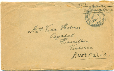
Documents, Deacon & Jay, Envelope, Letter, Military Pass and Postcard to Vida Holmes from Bill ( WT Harper ) 7358, pre 17 May 1917
... south of Merri St) Warrnambool great-ocean-road Vida Evelyn Holmes born 1903, Byaduk, second daughter of Joseph and Agnes Holmes, Byaduk. Worked as a nurse and died in Warrnambool hospital in 1928. 7358 Pte William Thomas Harper, born 1896, Byaduk, 8th Battalion-24th Reinforcements, embarked in Melbourne on HMAT A 70 Ballarat, and killed 3rd May 1918, aged 22 years, buried in Outtersteene Communnal Cemetery Extension, Bailleul, France, Grave HMAT A70 Ballarat, a transport ship sunk by a submarine in the English Channel vida holmes bill harper hmat a70 ballarat ww 1 byaduk letter postcard military pass 7358 1809.1-1R envelope: light sepia, ink postage stamp and black ink address and sender details, reverse has lead pencil calculations 1809.2-4R letter: buff writing paper, blue ink handwriting on both sides 1809.5-.5R military pass: printed, blue stamped and handwritten information, red signature Wm T Harper; reverse - black printed instruction and chart 1809.6-.9R postcards: Souvenir of Salisbury/Views Only, partial postmark.Miss Vida Holmes/Byaduk/Hamilton/Victoria/Australia Reverse inside note signed 'Yours Sincerely/Cousin Bill/ One of the "Ballarat' heroes/...s the King calls you/ Wednesday May 9th 1917Love to all the children/and Mother and Father 1809.1-1R envelope 14.5 x 9.00cm, opened along upper side 1809.2-4R letter 22.5 x 15.00cm, 3 pages of buff writing paper, handwritten blue on both sides 1809.5-.5R military pass 19,00 x 10.00cm, commercial pull out sheet, slight pertains on left hand side 1809.6-.9R postcards 14.00 x 9.00cm, sepia photographs/views, green ink, red 1d penny stamp and handwriting. ...Vida Evelyn Holmes born 1903, Byaduk, second daughter of Joseph and Agnes Holmes, Byaduk. Worked as a nurse and died in Warrnambool hospital in 1928. 7358 Pte William Thomas Harper, born 1896, Byaduk, 8th Battalion-24th Reinforcements, embarked in Melbourne on HMAT A 70 Ballarat, and killed 3rd May 1918, aged 22 years, buried in Outtersteene Communnal Cemetery Extension, Bailleul, France, Grave HMAT A70 Ballarat, a transport ship sunk by a submarine in the English Channel1809.1-1R envelope 14.5 x 9.00cm, opened along upper side 1809.2-4R letter 22.5 x 15.00cm, 3 pages of buff writing paper, handwritten blue on both sides 1809.5-.5R military pass 19,00 x 10.00cm, commercial pull out sheet, slight pertains on left hand side 1809.6-.9R postcards 14.00 x 9.00cm, sepia photographs/views, green ink, red 1d penny stamp and handwriting. 1809.1-1R envelope: light sepia, ink postage stamp and black ink address and sender details, reverse has lead pencil calculations 1809.2-4R letter: buff writing paper, blue ink handwriting on both sides 1809.5-.5R military pass: printed, blue stamped and handwritten information, red signature Wm T Harper; reverse - black printed instruction and chart 1809.6-.9R postcards: Souvenir of Salisbury/Views Only, partial postmark.Miss Vida Holmes/Byaduk/Hamilton/Victoria/Australia Reverse inside note signed 'Yours Sincerely/Cousin Bill/ One of the "Ballarat' heroes/...s the King calls you/ Wednesday May 9th 1917Love to all the children/and Mother and Fathervida holmes, bill harper, hmat a70 ballarat, ww 1, byaduk, letter, postcard, military pass, 7358 -
 Warrnambool and District Historical Society Inc.
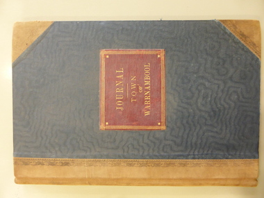
Financial record - Journal Town of Warrnambool 1906-1914, Circa 1906
... Warrnambool and District Historical Society Inc. 2 Gilles Street (south of Merri St) Warrnambool great-ocean-road This journal contains entries which relate to the expenses of the administration of the town in the early 20th Century. It contains entries which relate to items such as public works, kerbing and channelling ...This journal contains entries which relate to the expenses of the administration of the town in the early 20th Century. It contains entries which relate to items such as public works, kerbing and channelling, library and museum, abattoir fees, pure food act, limestone and bluestone road metal and salaries.The entries in this journal provide an overview of expenses and administration costs in early 20th century. There is much information contained in the costs which states when works were completed.Green cloth covered card journal with light brown leather spine and corners. Scrolled brown pattern down edges of spine cover. Edges of pages coloured in green, pink and yellow. Inside front and back covers is coloured light and dark blue. 103 pages. Maroon label on front cover with gold lettering and border. It contains three loose sheets of paper. One dated November 1912 written by H E Lawson calling on subscriptions to support a group to lobby for country interests. A second sheet refers to a poll for a new High School for Warrnambool. The other two sheets refer to voting rights. Journal Town of Warrnambool on front cover. Arnall and Jackson engravers and lithographers, Printers and manufacturing stationers 478 Collins St Melbourne No 96927 9/6/06.town of warrnambool1906-1914, warrnambool history, warrnambool town expenses 1910 -
 Eltham District Historical Society Inc
Photograph - Colour Print, Shire of Eltham, Kirwana Grove, Montmorency, c.1983
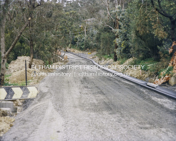
... south at present-day number 6 on right and present-day Kirwana Reserve on left. This photo was processed at the same time as image EDHS_07261 of roadworks in Sackville Street and EDHS_07262 of similar kerb and channel and sealing works in Bolton Street which has been dated as c.1983 (between Sep 1982 and May 1983)....south at present-day number 6 on right and present-day Kirwana Reserve on left. This photo was processed at the same time as image EDHS_07261 of roadworks in Sackville Street and EDHS_07262 of similar kerb and channel and sealing works in Bolton Street which has been dated as c.1983 (between Sep 1982 and May 1983). 1983 Footpaths and gutters Road construction road drainage Road Sealing Kirwana Grove Kirwana Reserve Montmorency Colour print on Kodak photographic paper 20.3 x 25.3 cm Kirwana Grove, Montmorency Photograph Colour Print Shire of Eltham ...Looking south at present-day number 6 on right and present-day Kirwana Reserve on left. This photo was processed at the same time as image EDHS_07261 of roadworks in Sackville Street and EDHS_07262 of similar kerb and channel and sealing works in Bolton Street which has been dated as c.1983 (between Sep 1982 and May 1983).1983, footpaths and gutters, road construction, road drainage, road sealing, kirwana grove, kirwana reserve, montmorency -
 Eltham District Historical Society Inc
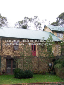
Photograph - Digital Photograph, Marguerite Marshall, Souter House, 23 Falkiner Street, Eltham, 20 June 2008
... south wall and the house remained unoccupied for some time. Sonia Skipper, one of Montsalvat’s builders who also worked for Alistair Knox oversaw rebuilding it. She employed landscape designer Gordon Ford, artist Peter Glass and Tim Burstall. The house originally had a cellar for making and storing wine, reputedly the first made in the district according to Alistair Knox in his book ‘We are what we stand on’ (p33). Water would seep into the cellar so Sonia’s father and then owner of the house, Mervyn Skipper bulldozed a channel...south wall and the house remained unoccupied for some time. Sonia Skipper, one of Montsalvat’s builders who also worked for Alistair Knox oversaw rebuilding it. She employed landscape designer Gordon Ford, artist Peter Glass and Tim Burstall. The house originally had a cellar for making and storing wine, reputedly the first made in the district according to Alistair Knox in his book ‘We are what we stand on’ (p33). Water would seep into the cellar so Sonia’s father and then owner of the house, Mervyn Skipper bulldozed a channel ...Originally built in the 1850s by Charles Souter from earth excavated from his property. It was a forerunner for a building style that was later to be synonymous with Eltham. The house is historically significant as the oldest mud brick building in the Shire of Nillumbik, as one of less than half a dozen buildings from the 1850s that survive in the Shire. It underwent several additions and alterations between c.1950s-1980s. It is also significant for its associations with Mervyn Skipper from the well-known Eltham family who was one of the founders of the artist's colony at Montsalvat. The house is architecturally significant because its north section was designed by the noted 'Eltham-style' architect, Alistair Knox, and the two long Oregon beams supporting the main floor were added by the noted 'Eltham-style' builder, Horrie Judd who built the southern room. A onetime tenant in the house, Judd built many Eltham houses and was a major builder of Montsalvat. The 1934 flood destroyed the south wall and the house remained unoccupied for some time. Sonia Skipper, one of Montsalvat’s builders who also worked for Alistair Knox oversaw rebuilding it. She employed landscape designer Gordon Ford, artist Peter Glass and Tim Burstall. The house originally had a cellar for making and storing wine, reputedly the first made in the district according to Alistair Knox in his book ‘We are what we stand on’ (p33). Water would seep into the cellar so Sonia’s father and then owner of the house, Mervyn Skipper bulldozed a channel outside to divert it. The Brocksopp family purchased the house in 1950 and added an outside door to the cellar and converted it into a gallery. Covered under Heritage Overlay, Nillumbik Planning Scheme. Published: Nillumbik Now and Then / Marguerite Marshall 2008; photographs Alan King with Marguerite Marshall.; p51This collection of almost 130 photos about places and people within the Shire of Nillumbik, an urban and rural municipality in Melbourne's north, contributes to an understanding of the history of the Shire. Published in 2008 immediately prior to the Black Saturday bushfires of February 7, 2009, it documents sites that were impacted, and in some cases destroyed by the fires. It includes photographs taken especially for the publication, creating a unique time capsule representing the Shire in the early 21st century. It remains the most recent comprehenesive publication devoted to the Shire's history connecting local residents to the past. nillumbik now and then (marshall-king) collection, eltham, falkiner street, mud brick building, mudbrick houses, souter house -
 Bendigo Historical Society Inc.
Photograph - COLIBAN MAIN CHANNEL, July,2009
... All photographs are of the Coliban Main Channel. Photo's 1,2,3,4 + 5 = were taken from South Mandurang Road, Spring Road end. ...All photographs are of the Coliban Main Channel. Photo's 1,2,3,4 + 5 = were taken from South Mandurang Road, Spring Road end. ...Photograph - colour. All photographs are of the Coliban Main Channel. Photo's 1,2,3,4 + 5 = were taken from South Mandurang Road, Spring Road end. Photo's 6,7,8,9,10,11,12 + 13 = were taken top of dirt road section of Springs Road. Photo's 14 + 15 = Taken between Sedgwick and North Harcourt, used to be called 'Prestonvale'. Photo No.14 is called Wirths Tunnel, 633 metres in length. Three more sheets of photo's of the Coliban Main Channel, between Sedgwick and Harcourt North. If more info.Ray Smith and Phil Wilkin - Bendigo Historical Society.place, water, coliban race, coliban main channel. -
 Phillip Island and District Historical Society Inc.
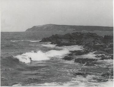
Photograph, Bryant West
... Phillip Island and District Historical Society Inc. phillip-island-and-the-bass-coast One of a collection of over 400 photographs in an album commenced in 1960 and presented to the Phillip Island & Westernport Historical Society by the Shire of Phillip Island local history photography photographs coastline eastern channel phillip island cape woolamai john jenner bryant west Photograph of Cape Woolamai looking south west across the Eastern Passage. ...One of a collection of over 400 photographs in an album commenced in 1960 and presented to the Phillip Island & Westernport Historical Society by the Shire of Phillip IslandPhotograph of Cape Woolamai looking south west across the Eastern Passage.local history, photography, photographs, coastline, eastern channel, phillip island, cape woolamai, john jenner, bryant west -
 Mission to Seafarers Victoria
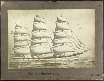
Photograph - Photograph, Sepia, Mounted, Ship Hiawatha Oct.1910, 1910
... Reckoned from the time she cleared the English Channel, her passage occupied only 76 days. Her best work was performed after passing Tristan d'Acunha in the South Atlantic Ocean. ...Reckoned from the time she cleared the English Channel, her passage occupied only 76 days. Her best work was performed after passing Tristan d'Acunha in the South Atlantic Ocean. ...The Hiawatha was a Norwegian windjammer sailing from Fredrikstadt. End of September 1910 the ship arrive nearly two weeks before its anticipated arrival date, making the trip in 81 days instead of a 100. Her arrival made the news in the Argus : SHIP HIAWATHA : A SMART VOYAGE. Seeing that she was not expected to arrive here for another couple of weeks or so the appear ance of the Norwegian ship Hiawatha at Port Phillip Heads yesterday morning caused some surprise. It was anticipated by shipping folk that her voyage from Fredrikstadt would occupy about 100 days which is a fair average passage but clipping a big slice off this allowance, the Hiawatha completed her long run from the Nor wegian port in the excellent time of 811/2 days, or within about 36 hours of the best effort previously made by a "windjammer" between these ports. An appropriate finish was given by the Hiawatha to this creditable voyage by a run of a little under three hours from the Heads up to Hobson's Bay, where she dropped anchor at about noon amid squalls of rain, which at times almost blinded her out from view. Few more 'racy' looking sailors than the Hiawatha have visited this port, and as she has proved on the present and many previous occasions sions, her looks do not belie her. Being laden with Baltic timber and in splendid sailing trim, the ship only required favourable winds to make a good voyage. These fell to her lot, and taking full advantage of every opportunity the vessel bowled across the ocean at steamboat speed. Reckoned from the time she cleared the English Channel, her passage occupied only 76 days. Her best work was performed after passing Tristan d'Acunha in the South Atlantic Ocean. From that stage to the meridian of the Cape of Good Hope she was only a week, whilst from the latter point to Hobson's Bay the ship made an equally capital run of 27 days, her best daily record being 29 knots, representing an hourly average speed of 12 knots. Several periods of exceptionally rough weather were passed through, but the ship suffered no ill effects. She will discharge at a berth up the river.One of the ships photograph that crew would leave at the Mission as a souvenir of their visit.Sepia photograph in cardboard frame of a three-masted full-rigged barque.On the photographic in white : Hiawatha On the frame in black: Ship Hiawatha - Oct. 1910hiawatha, windjammer, norway, full rigged barque, ships, crews and ships -
 Eltham District Historical Society Inc
Photograph, Looking south on Were Street towards Rattray Road, Montmorency, c.1940, 1940c
... channeling. The surrounds look very similar but no concrete kerb and trees in footpath significantly younger and smaller in size; hence c.1940 montmorency, railway station, were street Ilford FP-4 Roll of 35mm black and white negative film, sectioned into frames; copy of print photograph Looking south on Were Street towards Rattray Road, Montmorency, c.1940 Photograph ...Other photos of Were St featuring the Dandy family dated 8 October 1950 show an unsealed road with concrete kerb and channeling. The surrounds look very similar but no concrete kerb and trees in footpath significantly younger and smaller in size; hence c.1940Roll of 35mm black and white negative film, sectioned into frames; copy of print photograph Ilford FP-4montmorency, railway station, were street -
 Eltham District Historical Society Inc
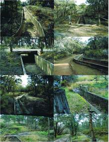
Slide, Maroondah Aqueduct, Research, Victoria, 22 Mar. 1981
... Of this length, 41 km were open channel, 10 km, tunnel through hills and 15 km in 14 inverted siphons across stream valleys. The route of the aqueduct is north of Tarrawarra and Yarra Glen, along the Yarra escarpment south of Christmas Hills and crossing Watsons Creek into the present Shire of Eltham near Henley Rd. ...Of this length, 41 km were open channel, 10 km, tunnel through hills and 15 km in 14 inverted siphons across stream valleys. The route of the aqueduct is north of Tarrawarra and Yarra Glen, along the Yarra escarpment south of Christmas Hills and crossing Watsons Creek into the present Shire of Eltham near Henley Rd. ...An inspection tour of the Maroondah Aqueduct was undertaken by the Shire of Eltham Historical Society on Sunday, March 22nd, 1981, commening where the aqueduct crosses Main Rd., Research, just below Eltham College. The Maroondah Aqueduct was part of Melbourne’s water supply system. It carried water over the 66 km from the Maroondah Reservoir on the Watts River at Healesville to the Preston Reservoir. Of this length, 41 km were open channel, 10 km, tunnel through hills and 15 km in 14 inverted siphons across stream valleys. The route of the aqueduct is north of Tarrawarra and Yarra Glen, along the Yarra escarpment south of Christmas Hills and crossing Watsons Creek into the present Shire of Eltham near Henley Rd. The eastern part of the route lies entirely within the former boundaries of the shire. The aqueduct passes south of Kangaroo Ground to Research and crosses the Diamond Creek by siphon at Allendale Rd., Eltham North. It then extends to Reservoir via St. Helena, Greensborough North and Bundoora. Water first flowed through the aqueduct in February 1891 when it was fed by a diversion weir on the Watts River. Records of the building of the aqueduct indicate that it was a significant construction achievement. The present Maroondah Reservoir was completed in 1927 and the aqueduct was enlarged at that time to take increased flows. About 1971 the section of the aqueduct through and north of Research was replaced by a large pipe and that section of the channel is now unused. The channel has remained largely intact (unlike sections at Greensborough and Bundoora where long lengths of the disused aqueduct have been demolished or filled in). The M.M.B.W. relinquished control of the disused aqueduct reserve which is crown land and the Shire of Eltham took control of this section of the reserve as a linear park. The Maroondah Aqueduct is considered to be an important historic structure, not just to the local area but to the metropolitan area generally. It is considered important to preserve substantially intact long lengths of the disused aqueduct, together with its bridges and other associated structures. 35 mm colour positive transparency (1 of 5) Mount - Agfachrome Agfa CS System black 8 dotsactivities, heritage excursion, maroondah aqueduct, research (vic.), shire of eltham historical society -
 Eltham District Historical Society Inc
Slide, Maroondah Aqueduct, Research, Victoria, 22 Mar. 1981
... Of this length, 41 km were open channel, 10 km, tunnel through hills and 15 km in 14 inverted siphons across stream valleys. The route of the aqueduct is north of Tarrawarra and Yarra Glen, along the Yarra escarpment south of Christmas Hills and crossing Watsons Creek into the present Shire of Eltham near Henley Rd. ...Of this length, 41 km were open channel, 10 km, tunnel through hills and 15 km in 14 inverted siphons across stream valleys. The route of the aqueduct is north of Tarrawarra and Yarra Glen, along the Yarra escarpment south of Christmas Hills and crossing Watsons Creek into the present Shire of Eltham near Henley Rd. ...An inspection tour of the Maroondah Aqueduct was undertaken by the Shire of Eltham Historical Society on Sunday, March 22nd, 1981, commening where the aqueduct crosses Main Rd., Research, just below Eltham College. The Maroondah Aqueduct was part of Melbourne’s water supply system. It carried water over the 66 km from the Maroondah Reservoir on the Watts River at Healesville to the Preston Reservoir. Of this length, 41 km were open channel, 10 km, tunnel through hills and 15 km in 14 inverted siphons across stream valleys. The route of the aqueduct is north of Tarrawarra and Yarra Glen, along the Yarra escarpment south of Christmas Hills and crossing Watsons Creek into the present Shire of Eltham near Henley Rd. The eastern part of the route lies entirely within the former boundaries of the shire. The aqueduct passes south of Kangaroo Ground to Research and crosses the Diamond Creek by siphon at Allendale Rd., Eltham North. It then extends to Reservoir via St. Helena, Greensborough North and Bundoora. Water first flowed through the aqueduct in February 1891 when it was fed by a diversion weir on the Watts River. Records of the building of the aqueduct indicate that it was a significant construction achievement. The present Maroondah Reservoir was completed in 1927 and the aqueduct was enlarged at that time to take increased flows. About 1971 the section of the aqueduct through and north of Research was replaced by a large pipe and that section of the channel is now unused. The channel has remained largely intact (unlike sections at Greensborough and Bundoora where long lengths of the disused aqueduct have been demolished or filled in). The M.M.B.W. relinquished control of the disused aqueduct reserve which is crown land and the Shire of Eltham took control of this section of the reserve as a linear park. The Maroondah Aqueduct is considered to be an important historic structure, not just to the local area but to the metropolitan area generally. It is considered important to preserve substantially intact long lengths of the disused aqueduct, together with its bridges and other associated structures. 35 mm colour positive transparency (1 of 5) Mount - Agfachrome Agfa CS System black 8 dotsactivities, heritage excursion, maroondah aqueduct, research (vic.), shire of eltham historical society -
 Victorian Interpretive Projects Inc.
Photograph - Colour, Clare Gervasoni, Kerb and Channelling at Armstrong Street South, Ballarat, 1916, 24/03/2016
... A number of colour photographs showing concrete kerb and channeling at Armstrong Street South, Ballarat, taken from South Street. ...PO Box 93R, Redan, 3350 goldfields Armstrong Street South South Street Ballarat kerb and channelling roadworks bluestone gutters A number of colour photographs showing concrete kerb and channeling at Armstrong Street South, Ballarat, taken from South Street. ...A number of colour photographs showing concrete kerb and channeling at Armstrong Street South, Ballarat, taken from South Street. Although in an heritage overlay, the kerb and channeling changed the heritage feel of the block. Some photos show original bluestone gutters that were not destroyed during the process.armstrong street south, south street, ballarat, kerb and channelling, roadworks, bluestone gutters -
 Bendigo Historical Society Inc.
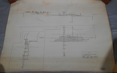
Plan - Central Red, White and Blue Mine
... Author: H E Whitelaw Share Abstract Early in 1910, some considerable time after it had become generally known that a rich reef at a depth of 405 ft was being worked southward from the privately owned Lansell's Little 180 shaft and immediately following the plotting of the Geological Survey pitch diagram of the Sheepshead line of reefs, some wide awake local mining men seized the opportunity to secure the holding known as Eadie's which, overlapping Lansell's lease and containing a stretch of the Sheepshead reef channel between the Little 180 north and south shafts, had been declared void some five years previously. ...Author: H E Whitelaw Share Abstract Early in 1910, some considerable time after it had become generally known that a rich reef at a depth of 405 ft was being worked southward from the privately owned Lansell's Little 180 shaft and immediately following the plotting of the Geological Survey pitch diagram of the Sheepshead line of reefs, some wide awake local mining men seized the opportunity to secure the holding known as Eadie's which, overlapping Lansell's lease and containing a stretch of the Sheepshead reef channel between the Little 180 north and south shafts, had been declared void some five years previously. ...The Central Red White and Blue Gold Mine was Bendigo's leading gold mine from 1910 - 1913. During the mine's operation, the main shaft was sunk 670 metres, and retrieved over 2500KG of gold. The Central Red White and Blue Gold Mine was located on the corner of Chum St and Honeysuckle St in Golden Square. Extract from Whitelaw Report: Central Red White and Blue Mine, Bendigo. Author: H E Whitelaw Share Abstract Early in 1910, some considerable time after it had become generally known that a rich reef at a depth of 405 ft was being worked southward from the privately owned Lansell's Little 180 shaft and immediately following the plotting of the Geological Survey pitch diagram of the Sheepshead line of reefs, some wide awake local mining men seized the opportunity to secure the holding known as Eadie's which, overlapping Lansell's lease and containing a stretch of the Sheepshead reef channel between the Little 180 north and south shafts, had been declared void some five years previously. That the Lansell Estate did not acquire this property on its becoming available is puzzling in the light of the fact that in Eadie's day the late Mr G W Lansell, on discovering auriferous spurs in the south shaft (now the Central Blue) had offered 2,000 pounds for, and a percentage of gold won from the lease. https://search.informit.org/doi/10.3316/aesis.200105326 Draftsman's drawing of Central Red, White and Blue Mine Map. Printed by Troedel & Cooper Pty Ltd. Mr. H. Cundy, Surveyor Forms part of the Margaret Roberts Collection of mining records.bendigo, gold, map, mine, central red white & blue, margaret roberts collection, sheepshead reef -
Port Melbourne Historical & Preservation Society
Document - Specification, Metalling and chanelling, Boundary Street South, Graham Street to St Vincents Street, Arthur Victor Heath, Town Clerk et al, 14 Mar 1893
... Specifications (Reg. 77.1) and plan (Reg 77.2) for metalling and channelling Boundary Street South [Pickles Street] from Graham Street to St. ...Bartlett (Mayor) Specifications (Reg. 77.1) and plan (Reg 77.2) for metalling and channelling Boundary Street South [Pickles Street] from Graham Street to St. ...Specifications (Reg. 77.1) and plan (Reg 77.2) for metalling and channelling Boundary Street South [Pickles Street] from Graham Street to St. Vincents Street. Loan works 1893, plan No. 5.A.V. Heath (Town Surveyor):J.J. Bartlett (Mayor)engineering - roads streets lanes and footpaths, town planning, town clerks, mayors, arthur victor heath, james john bartlett