Showing 16 items matching "south gippsland highway"
-
 Federation University Historical Collection
Reports, Big Cats Sightings and Stock Kills 2000-2011, 2000-2011
... ...south Gippsland Highway...The folder was collected for research being conducted by David Waldron. australian mythical animals collection david waldron Department of Primary Industries rangers peter walsh Warragul creek Binginwarri Coongulla Straford Licola Blanket Hill Darramin Blanket Hill Woodside BEach heyfield puma panther cowwarr glenmaggie bolands bluff darrimen bolands bluff binginnwarri dawson the springs mt taylor black range driffield west Snowy plains airstrip glenmaggie north jack smith lake munro briagaling dutson downs connors plain giffard west darriment Joyces Road Junction Giffard West wallaby creek south Gippsland Highway avon river orbost four mile creek Folder of reports of Big Cat by rangers. ...The folder or correspondence is the result of a Freedom of Informaition request made to the Department of Primary Industries in 2011. The folder was collected for research being conducted by David Waldron.Folder of reports of Big Cat by rangers. australian mythical animals collection, david waldron, department of primary industries, rangers, peter walsh, warragul creek, binginwarri, coongulla, straford, licola, blanket hill, darramin, blanket hill, woodside beach, heyfield, puma, panther, cowwarr, glenmaggie, bolands bluff, darrimen, bolands bluff, binginnwarri, dawson, the springs, mt taylor, black range, driffield west, snowy plains airstrip, glenmaggie north, jack smith lake, munro, briagaling, dutson downs, connors plain, giffard west, darriment, joyces road junction, giffard west, wallaby creek, south gippsland highway, avon river, orbost, four mile creek -
 Lakes Entrance Historical Society
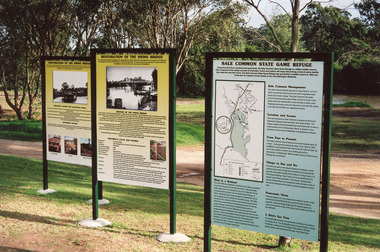
Photograph - Bridges, 2003
... Colour photograph showing information boards giving the history of the iconic bridge and its relationship to the Gippsland Lakes historic swing bridge over the Latrobe River. The South Gippsland Highway no longer uses the swing bridge since two new bridges have been built a little upstream on the Latrobe River. ...Bridges Waterways Local History Display Colour photograph showing information boards giving the history of the iconic bridge and its relationship to the Gippsland Lakes historic swing bridge over the Latrobe River. The South Gippsland Highway no longer uses the swing bridge since two new bridges have been built a little upstream on the Latrobe River. ...Also thirteen other photographs showing bridge open and closed.Colour photograph showing information boards giving the history of the iconic bridge and its relationship to the Gippsland Lakes historic swing bridge over the Latrobe River. The South Gippsland Highway no longer uses the swing bridge since two new bridges have been built a little upstream on the Latrobe River. Longford Victoria.bridges, waterways, local history, display -
 Orbost & District Historical Society
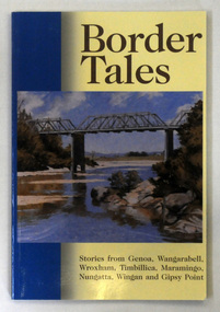
book, Border Tales, 2000
... Gippsland, Victoria. It is close to the New South Wales border where the Princes Highway crosses the Genoa River....Gippsland, Victoria. It is close to the New South Wales border where the Princes Highway crosses the Genoa River. ...The book was compiled by Peter Allard and Geoff Alves and published by the Genoa Town Committee. Genoa is a small town in East Gippsland, Victoria. It is close to the New South Wales border where the Princes Highway crosses the Genoa River.A paperback book of 120pp titled Border tales : stories from Genoa, Wangarabell, Wroxham, Timbillica, Maramingo, Nungatta, Wingan and Gipsy Point. On the front cover is a coloured picture of the bridge across the Genoa river at Genoa. -
 Ringwood and District Historical Society
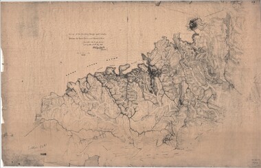
Map, Survey of Dividing Range between Yarra Yarra and Western Port - William Wedge Darke, 1843
... Gippsland and to the higher country about Alexandra and Mansfield, sometimes known as White Horse Road, and now Maroondah Highway. Transmitted to the Surveyor General with my letter of 10th May 1843 (signed) Wm Wedge Drake, Assistant Surveyor. Scale: two inches to a mile. Descriptive remarks include upstream area of Yarra River - "impassable, appears to have been formerly a lake", and to the south ...Extract - Ringwood, Place of Many Eagles - Hugh Anderson (1974): William Wedge Darke, from Hereford, England, was a nephew of John Helder Wedge of the Port Phillip Association, who was also a surveyor. William's most important work was probably his survey of the Dividing Range and the country between the Yarra River and Western Port, completed in May 1843, and during which he made a traverse between the Mullum and Dandenong creeks along the higher ground that he labelled the "best line of road from Melbourne". This road was for many years the major route to Gippsland and to the higher country about Alexandra and Mansfield, sometimes known as White Horse Road, and now Maroondah Highway.Surveyor's relief map of features to the east of Melbourne including Yarra Yarra River, Mullum Mullum Creek, Anderson's Creek, Dandenong Creek.Transmitted to the Surveyor General with my letter of 10th May 1843 (signed) Wm Wedge Drake, Assistant Surveyor. Scale: two inches to a mile. Descriptive remarks include upstream area of Yarra River - "impassable, appears to have been formerly a lake", and to the south - "barren and scrubby swamps of the Western Port Country". Marked tracks include "best line of road from Melbourne", "track to Dandenong", "Road to Port Albert may probably be found on this range", "Best line to Upper Yarra". Several huts also marked. -
 Orbost & District Historical Society
black and white photograph, late 19th century - early 20th century
... Highway, 27 km east of Orbost in East Gippsland. The first white settler arrived in the valley in 1887 cutting a dray track from Marlo to the south-west. ...gippsland This is a photograph of Alice Swallow's hotel at Cabbage Tree. The settlement of Cabbage Tree Creek is located on the Princes Highway, 27 km east of Orbost in East Gippsland. The first white settler arrived in the valley in 1887 cutting a dray track from Marlo to the south ...This is a photograph of Alice Swallow's hotel at Cabbage Tree. The settlement of Cabbage Tree Creek is located on the Princes Highway, 27 km east of Orbost in East Gippsland. The first white settler arrived in the valley in 1887 cutting a dray track from Marlo to the south-west. Several families cleared the alluvial flats, growing maize, peas and beans and raising pigs, cattle and sheep. Later the farmers milked cows, sending cream to Orbost. In the late 1890s, small quantities of alluvial gold were found in the creek. A school commenced classes in 1913, but enrolment was small and at times the school operated part time with several other small schools in the area. The school building served as a hall for the district. From the 1920s the Cabbage Tree Hotel catered to drivers on the improved Princes Highway. (info. from Victorian Places)This is a pictorial record of Cabbage Tree, East Gippsland in the late 20th century. It shows a building that no longer exists.A black / white photograph of a small, single - storey wooden building in a bush setting. There are people standing in front of the building with a horse and wagon nearby. In the foreground is a wagon with four horses hitched to it and the driver seated behind the horses. -
 Orbost & District Historical Society
black and white photograph, 1924
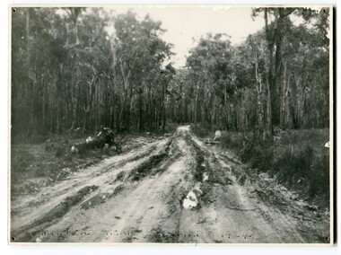
... Gippsland, in 1924. This road would have been the Princes Highway, a main thoroughfare through to New South Wales. ...Gippsland, in 1924. This road would have been the Princes Highway, a main thoroughfare through to New South Wales. ...This photograph shows the main road near Bellbird, East Gippsland, in 1924. This road would have been the Princes Highway, a main thoroughfare through to New South Wales. Bellbird Creek is a small rural location between Orbost and Cann River. There was no township at Cabbage Tree at this time. The Cabbage Tree Creek township was established to support the booming timber industry of the mid 20th century. Five timber mills worked full time supporting the families that were drawn to the area's wealth of natural resources. Nestled on the banks of the Cabbage Tree Creek, the township was built by those mills to house their workers. Today although the timber mills have disappeared, some of the buildings still remain. Little now remains to remind of the saw-milling history apart from photographs and some relics - a boiler and a brick furnace. There was also a thriving agricultural community farming dairy, beef, seed beans and fresh peas and beans that were sent to the Victoria Market in Melbourne. Dairy farming still plays an essential role in the township. this is a pictorial record of the Princes Highway, the main road from East Gippsland to the New South Wales border.A large black / white photograph of a very wet and boggy bush road.on front - "Main Rd near Bellbird 1924"road princes-highway bellbird-creek-1924 -
 Orbost & District Historical Society
black and white photograph, first half 20th century
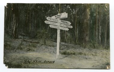
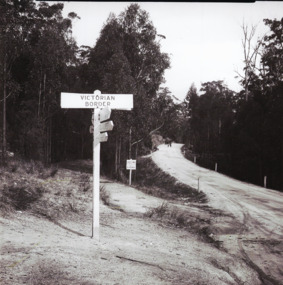
... highway through East Gippsland. The distances are indicated in miles, a measurement standard no longer in use. Princes-Highway-East-Gippsland road-transport road-sign on front - Vic - NSW Border A black / white photograph postcard of the signpost at the Victorian - New South Wales border. ...Prior to the sealing of the Princes Highway west of Orbost, the road surface was anything but good, even by C1917 when cars started to use the road. From Orbost the old road via Marlo to Sydenham was abandoned for the new location which traversed more rugged country via Cabbage Tree, Bell Bird and Club Terrace to Cann River, and the reason for this diversion was on account of settlements being established at Murrungowar and Club Terrace, at which latter place there was a temporary rush to obtain gold. This road was constructed by the Public Works department and a maximum grade of 1 in 19 was adopted, and as speed was not to be catered for the grade followed in and out round the spurs and gullies, resulting in a maze of turns and twists which required a good deal of skill on the part of the horse driver to negotiate." - Bairnsdale Advertiser, Friday, May 2, 1947. (More information from Newsletter February 2010)This is a pictorial record of an early road distance sign on a major highway through East Gippsland. The distances are indicated in miles, a measurement standard no longer in use.A black / white photograph postcard of the signpost at the Victorian - New South Wales border. It shows distances to Sydney and Eden on one arrow and distances to Melbourne and Genoa on another. on front - Vic - NSW Borderprinces-highway-east-gippsland road-transport road-sign -
 Orbost & District Historical Society
black and white photograph, 1920s -1930s
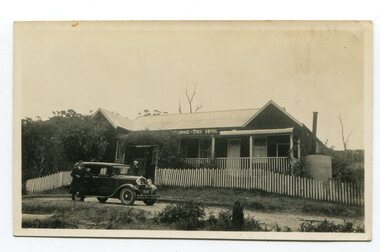
... Highway, 27 km east of Orbost in East Gippsland. The first white settler arrived in the valley in 1887 cutting a dray track from Marlo to the south-west. ...gippsland The Cabbage Tree Creek township was originally established to support the booming timber industry of the mid 20th century. Five timber mills worked full time supporting the families that were drawn to the area's wealth of natural resources. The settlement of Cabbage Tree Creek is located on the Princes Highway, 27 km east of Orbost in East Gippsland. The first white settler arrived in the valley in 1887 cutting a dray track from Marlo to the south ...The Cabbage Tree Creek township was originally established to support the booming timber industry of the mid 20th century. Five timber mills worked full time supporting the families that were drawn to the area's wealth of natural resources. The settlement of Cabbage Tree Creek is located on the Princes Highway, 27 km east of Orbost in East Gippsland. The first white settler arrived in the valley in 1887 cutting a dray track from Marlo to the south-west. Several families cleared the alluvial flats, growing maize, peas and beans and raising pigs, cattle and sheep. Later the farmers milked cows, sending cream to Orbost. In the late 1890s, small quantities of alluvial gold were found in the creek. A school commenced classes in 1913, but enrolment was small and at times the school operated part time with several other small schools in the area. The school building served as a hall for the district. From the 1920s the Cabbage Tree Hotel catered to drivers on the improved Princes Highway. (info. from Victorian Places)This is a pictorial record of Cabbage Tree, East Gippsland in the late 20th century. It shows a building that no longer exists.A small black / white photograph of a single storey timber building. On a sign below the roof is "Cabbage Tree Hotel". The hotel is surrounded by a wooden picket fence. A man and woman are standing on either side of a motor car parked on the roadway in front of the building.on back - on label - Cabbage Tree Hotelcabbage-tree-hotel -
 Orbost & District Historical Society
black and white photograph, 1913
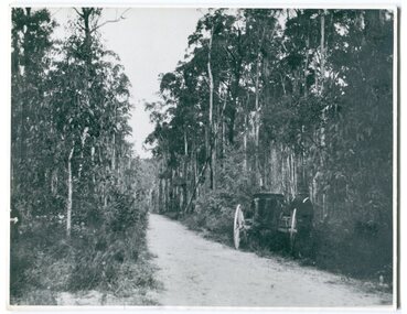
... Orbost & District Historical Society Ruskin Street Orbost gippsland This photograph shows the regrowth of vegetation on the road between Genoa and the border - now the Princes Highway. This is a pictorial record of the main road from Orbost to the New South border, The Princes Highway, in the early 20th century. princes-highway-genoa transport on back - " Princes Highway showing the regrowth.....1913" A large black / white photograph of a bush road wwith a vehicle and a man on the side of it. black and white photograph ...This photograph shows the regrowth of vegetation on the road between Genoa and the border - now the Princes Highway.This is a pictorial record of the main road from Orbost to the New South border, The Princes Highway, in the early 20th century.A large black / white photograph of a bush road wwith a vehicle and a man on the side of it.on back - " Princes Highway showing the regrowth.....1913"princes-highway-genoa transport -
Federation University Historical Collection
Document - Reports, Large Cats, Thylacenes and Large Predators Sigtings, 1975-1985 and 2002-2011
... highway sightings...kevin phelen...mt richmond national park...feral cat...felis catus...lancefield...pyalong...broadford...pyalong pantherleopard...porsche park...dick shaw...big cats in victoria...peter hall...lyn sellens...south gippsland...The folder was collected for research being conducted by David Waldron. australian mythical animals collection david waldron brian waters moonambel joyce collins ian smith thylacene marrarkuli burragorang m.g. hornocker mt bepcha billywing upland john a. henry bryan wlaters ken bodinnar harcourt kevin farley fowlers bay carolyn hodges puma macarthur paynesville john aldreson animal damage control mountain lion bryan walters cougar big cat maryborough joan kirner bernard mace tasmanian tigers d.g. willey calder highway sightings kevin phelen mt richmond national park feral cat felis catus lancefield pyalong broadford pyalong pantherleopard porsche park dick shaw big cats in victoria peter hall lyn sellens south gippsland plaster cast foot cast unidentified wildlife john seeback michael moss carnivores halls gap halls gap puma scats kooreh ballan ballan large cat a.g. kerr south gippsland tasmanian tiger sightings central victorian puma otways wilsons promontory john higgins tasmanian wolf j.k. depmster vermin lion cooper's creek warrego river dingo thylacinus cynocephalus mirboo north newham operation puma victoria australian skeptics kangaroo ground rare fauna black wildcat pyalong panther bob warneke black puma maryborough puma creswick panther cape bridgewater pyrenees panther footprints daisy hill bung bong phantom puma geranium springs maurice hornocker Folder of correspondence and newsclips relating to "Big Cats" and other large predators. ...The folder of correspondence is the result of a Freedom of Information request made to the Department of Sustainability and Environment in 2011. The folder was collected for research being conducted by David Waldron.Folder of correspondence and newsclips relating to "Big Cats" and other large predators. Please note: sections of this file are closed to protect the privacy of correspondents.australian mythical animals collection, david waldron, brian waters, moonambel, joyce collins, ian smith, thylacene, marrarkuli, burragorang, m.g. hornocker, mt bepcha, billywing upland, john a. henry, bryan wlaters, ken bodinnar, harcourt, kevin farley, fowlers bay, carolyn hodges, puma, macarthur, paynesville, john aldreson, animal damage control, mountain lion, bryan walters, cougar, big cat, maryborough, joan kirner, bernard mace, tasmanian tigers, d.g. willey, calder highway sightings, kevin phelen, mt richmond national park, feral cat, felis catus, lancefield, pyalong, broadford, pyalong pantherleopard, porsche park, dick shaw, big cats in victoria, peter hall, lyn sellens, south gippsland, plaster cast, foot cast, unidentified wildlife, john seeback, michael moss, carnivores, halls gap, halls gap puma scats, kooreh, ballan, ballan large cat, a.g. kerr, south gippsland tasmanian tiger sightings, central victorian puma, otways, wilsons promontory, john higgins, tasmanian wolf, j.k. depmster, vermin, lion, cooper's creek, warrego river, dingo, thylacinus cynocephalus, mirboo north, newham, operation puma victoria, australian skeptics, kangaroo ground, rare fauna, black wildcat, pyalong panther, bob warneke, black puma, maryborough puma, creswick panther, cape bridgewater, pyrenees panther, footprints, daisy hill, bung bong, phantom puma, geranium springs, maurice hornocker -
 Orbost & District Historical Society
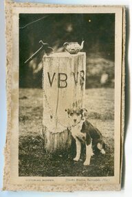
Photograph - V B post - Victorian Border, Crown Studios ( W Stanley Vogt), c.1920s-1950s
... The Victorian/New South Wales border is near Genoa in Far East Gippsland. This post marked this border and was positioned beside the Highway. ...The Victorian/New South Wales border is near Genoa in Far East Gippsland. This post marked this border and was positioned beside the Highway. ...The Victorian/New South Wales border is near Genoa in Far East Gippsland. This post marked this border and was positioned beside the Highway. For many years, the border was an important stopping point because it also had a Fruit Fly inspection point for traffic coming into Victoria from N S Wales.This photograph is significant because it is a rare image of a marker post which was once very important. A b/w photograph/postcard of a square post, painted white with the letters W B stencilled into it. The post has a Tea Pot on top, and a small axe. A b/w dog is sitting nearby and appears to be attached to the post by a chain. Victorian Border. Crown Studios, Bairnsdale, Vic.victorian border, nsw border, marker post, princes highway -
 Lakes Entrance Historical Society
Photograph - Post Office/Roadknight house/Johnsonviille, 1997
... Lakes Entrance Historical Society 4 Marine Parade Lakes Entrance gippsland This home and Post Office was run by Mrs James Roadknight nee Annie Smith Houses Heritage Study Postal Services Colour photograph showing aspect of the former Johnsonville Post Office and residence. A substantial timber residence painted white, hipped roof, bullnose veranda on front and east side. The Post Office was originally detached, later moved to south east corner of house. Situated on Princes Highway ...This home and Post Office was run by Mrs James Roadknight nee Annie SmithColour photograph showing aspect of the former Johnsonville Post Office and residence. A substantial timber residence painted white, hipped roof, bullnose veranda on front and east side. The Post Office was originally detached, later moved to south east corner of house. Situated on Princes Highway western end of Johnsonville Victoria. Plus two other photos (02510.8 and 02510.8a) houses, heritage study, postal services -
 Lakes Entrance Historical Society
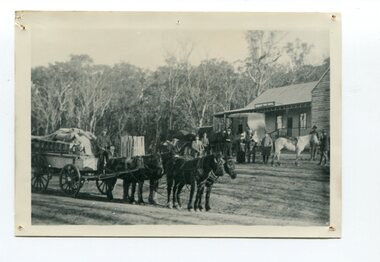
Photograph - Harry Froud's coach factory, P Hancock, 1900 c
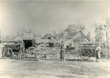
... Lakes Entrance Historical Society 4 Marine Parade Lakes Entrance gippsland Henry Froud's Blacksmith Coach Building and Wheelwright's business set up at original surveyed site west of present township, nearer to cemetery turnoff,. Business first moved to corner of Princes Highway and Bruthen Road, (now site of Black Stump Store), then moved to premises built by Harry Froud on south side of highway, corner of Punt Road, (present site of BP Garage). ...Henry Froud's Blacksmith Coach Building and Wheelwright's business set up at original surveyed site west of present township, nearer to cemetery turnoff,. Business first moved to corner of Princes Highway and Bruthen Road, (now site of Black Stump Store), then moved to premises built by Harry Froud on south side of highway, corner of Punt Road, (present site of BP Garage).Black and white photograph of Harry Frouds first coach factory west of present township, showing three men in front of four wheeled vehicles including a steam engine. Three workshops in background, two having bark roofs, man in centre identified as Harry Froud, William Henry. Johnsonville Victoria. transport, factory, people, local history -
 Lakes Entrance Historical Society
Photograph - Victoria/N.S.W. Border, 1950 c
... Lakes Entrance Historical Society 4 Marine Parade Lakes Entrance gippsland Another black and white photographs of tree ferns and scenery along the Princes Highway 05316. 1 Roads and Streets borders Vegetation Black and white photograph of Princes Highway as gravel road at Victoria N.S.W. border looking south to Victoria Photograph Victoria/N.S.W. ...Another black and white photographs of tree ferns and scenery along the Princes Highway 05316. 1 Black and white photograph of Princes Highway as gravel road at Victoria N.S.W. border looking south to Victoriaroads and streets, borders, vegetation -
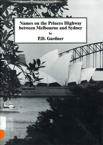 Victorian Aboriginal Corporation for Languages
Book, P D Gardner, Names on the Princes Highway between Melbourne and Sydney : their origins, meanings and history, 2000
... Victorian Aboriginal Corporation for Languages 33 Saxon Street Brunswick melbourne Dandenong Genoa South Coast NSW Yarra River Moruya Kiama Captain Cook East Gippsland Rosedale Maps, b&w illustrations Place name list in a specific area. Giving descriptions and meanings. Names on the Princes Highway ...Place name list in a specific area. Giving descriptions and meanings.Maps, b&w illustrationsdandenong, genoa, south coast nsw, yarra river, moruya, kiama, captain cook, east gippsland, rosedale -
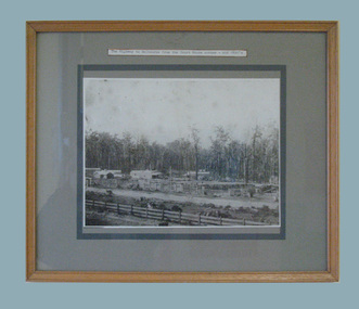 South Gippsland Shire Council
Photograph - Set of Five Photographs
... South Gippsland Shire Council 9 Smith Street Leongatha gippsland Set of five black and white photographs showing early Leongatha and Shire Councillors. Set in grey window mount in a natural wooden frame. 1. The Highway ...Set of five black and white photographs showing early Leongatha and Shire Councillors. Set in grey window mount in a natural wooden frame. 1. The Highway to Melbourne from the Court House corner - mid 1890's 2. McCartin Street looking west - about 1890 3. First Council - 1888 4. Looking east from the Railway Station - mid 1890's 5. Bair Street and the construction of the railway - 1890