Showing 79 items matching "st helena creek"
-
 Greensborough Historical Society
Photograph - Digital image, St Helena and Diamond Creek Roads, 1925c
... St Helena and Diamond Creek Roads...st helena road...diamond creek...Photograph of the intersection of St Helena and Diamond Creek Roads pre-1950. The scene is rural....Greensborough Historical Society 34A Glenauburn Road Lower Plenty Lower Plenty melbourne Photograph of the intersection of St Helena and Diamond Creek Roads pre-1950. The scene is rural. st helena road diamond creek road greensborough Digital copy of black and white photograph. ...Photograph of the intersection of St Helena and Diamond Creek Roads pre-1950. The scene is rural.Digital copy of black and white photograph.st helena road, diamond creek road, greensborough -
 Greensborough Historical Society
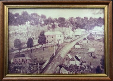
Photograph - Photograph (Framed), St Helena and Diamond Creek Roads Greensborough 1889, 1889
... St Helena and Diamond Creek Roads Greensborough 1889...A view of Greensborough township 1889, painted from the corner of St Helena Road and Diamond Creek Roads. This copy has been cropped from the original to show lower Main Street and Marble hall. ...Greensborough Historical Society 34A Glenauburn Road Lower Plenty Lower Plenty melbourne A view of Greensborough township 1889, painted from the corner of St Helena Road and Diamond Creek Roads. This copy has been cropped from the original to show lower Main Street and Marble hall. ...A view of Greensborough township 1889, painted from the corner of St Helena Road and Diamond Creek Roads. This copy has been cropped from the original to show lower Main Street and Marble hall. The original of this painting is owned by Greensborough Primary School.From the John Mackey collection. this item was displayed at the offices of Ryan, Mackey and Kelly, solicitors, Main Street Greensborough.Small timber-framed photograph of road and houses, sepia.greensborough, main street greensborough, marble hall greensborough, arthur elliott, john mackey -
![Photograph - Digital image, House St Helena and Diamond Creek Roads [Greensborough], 02/05/2013](/media/collectors/4f729f5697f83e03086015b8/items/5729bbd22162f108e8de5be2/item-media/5729bc112162f108e8de617d/item-fit-380x285.jpg?cb=6) Greensborough Historical Society
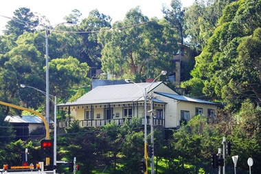
Greensborough Historical SocietyPhotograph - Digital image, House St Helena and Diamond Creek Roads [Greensborough], 02/05/2013
... House St Helena and Diamond Creek Roads [Greensborough]...st helena road greensborough...diamond creek...These photographs of the house on the corner of St Helena and Diamond Creek Roads was taken in 2013 to show changes over 40 years, based on Ron Reynold's sketches in the 1973 publication 'Greensborough and Greenhills' published by Cypress Books... which states "Built on a steep hill in a bush setting in the early 1920s, for a Dr Wood, the weatherboard house now overlooks an area of activity and change. ...House St Helena and Diamond Creek Roads [Greensborough] Photograph - Digital image ...These photographs of the house on the corner of St Helena and Diamond Creek Roads was taken in 2013 to show changes over 40 years, based on Ron Reynold's sketches in the 1973 publication 'Greensborough and Greenhills' published by Cypress Books... which states "Built on a steep hill in a bush setting in the early 1920s, for a Dr Wood, the weatherboard house now overlooks an area of activity and change. The owners, Mr and Mrs E. 'Bluey' Blackburn, remember when their 3/4 acre building block dropped to the edge of a dirt road. Today the view from the high verandah encompasses the Main Street shopping centre, new and old bridges, new roads and houses, the Plenty River, natural bush, hills and sports grounds."Digital copy of colour photograph.greensborough and greenhills, st helena road greensborough, diamond creek road greensborough, wood family, ron reynolds -
 Greensborough Historical Society
Photograph - Digital image, Dr Woods House corner St Helena and Diamond Creek Roads Greensborough, 21/05/2014
... Dr Woods House corner St Helena and Diamond Creek Roads Greensborough...diamond creek road...st helena...A landmark house in the Greensborough area (belonging to Dr Woods in he 1920s), situated on the corner of Diamond Creek and St Helena Roads....Dr Woods House corner St Helena and Diamond Creek Roads Greensborough Photograph - Digital image ...A landmark house in the Greensborough area (belonging to Dr Woods in he 1920s), situated on the corner of Diamond Creek and St Helena Roads.Digital copy of colour photograph.diamond creek road, st helena road -
 Greensborough Historical Society
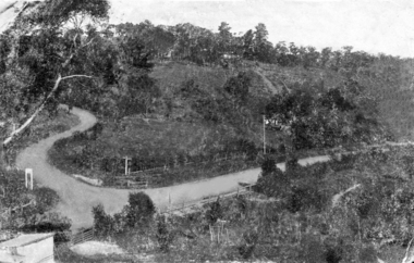
Photograph - Digital Image, View from Sondemeyers, 1925c
... st helena road...diamond creek...Photograph shows a view of Greensborough from 'Sondemeyers Hill' located near the corner of St Helena and Diamond Creek Roads. It looks south towards the township of Greensborough. ...It is a rural scene. st helena road diamond creek road sondemeyers hill greensborough Digital copy of black and white photograph. ...Photograph shows a view of Greensborough from 'Sondemeyers Hill' located near the corner of St Helena and Diamond Creek Roads. It looks south towards the township of Greensborough. It is a rural scene.Digital copy of black and white photograph.st helena road, diamond creek road, sondemeyers hill, greensborough -
 Eltham District Historical Society Inc
Photograph, George W. Bell, Smiths Dam, Eltham, 1961, 1961
... ...st helena creek...Eltham District Historical Society Inc 728 Main Rd Eltham melbourne karingal drive st helena road d.b smith eltham west drain karingal creek st helena creek dams george w bell collection Black and white photograph of concrete dam on Smith property Karingal Drive Eltham 1961 Smiths Dam, Eltham, 1961 Photograph George W. ...Black and white photograph of concrete dam on Smith property Karingal Drive Eltham 1961karingal drive, st helena road, d.b smith, eltham west drain, karingal creek, st helena creek, dams, george w bell collection -
 Greensborough Historical Society
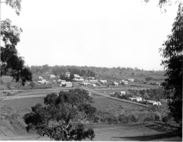
Slide - Photograph, John Ramsdale, Greensborough Park: Slide 44, 1990s
... st helena road greensborough...diamond creek...Photograph shows Greensborough Park from the corner of St Helena and Diamond Creek Roads Greensborough...Greensborough Historical Society 34A Glenauburn Road Lower Plenty Lower Plenty melbourne Photograph shows Greensborough Park from the corner of St Helena and Diamond Creek Roads Greensborough Part of the John Ramsdale collection of slides and audio visual material. greensborough park st helena road greensborough diamond creek road greensborough No maker's marks. ...Photograph shows Greensborough Park from the corner of St Helena and Diamond Creek Roads GreensboroughPart of the John Ramsdale collection of slides and audio visual material.Colour photograph scanned from slide.No maker's marks. No caption on slide.greensborough park, st helena road greensborough, diamond creek road greensborough -
 Greensborough Historical Society
Photograph - Digital Image, Pioneer Reserve 2014 -2, 01/10/2014
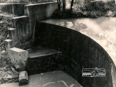
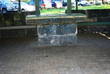
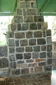
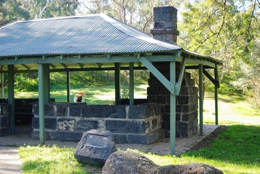
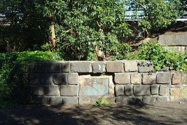
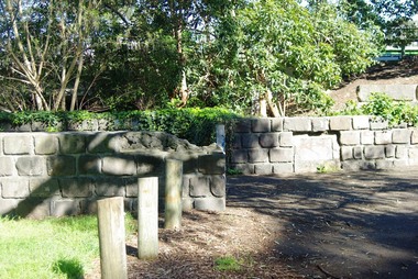
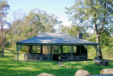
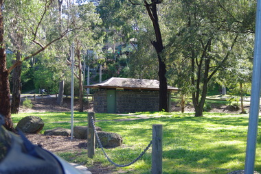
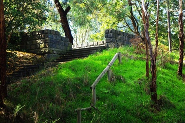
... Pioneer Reserve, Greensborough is a small park on the corner of St Helena and Diamond Creek Roads. It is adjacent to the site of Greensborough's first bridge across the Plenty River, c. 1864 - 1960s. ...Greensborough Historical Society 34A Glenauburn Road Lower Plenty Lower Plenty melbourne Pioneer Reserve, Greensborough is a small park on the corner of St Helena and Diamond Creek Roads. It is adjacent to the site of Greensborough's first bridge across the Plenty River, c. 1864 - 1960s. ...Pioneer Reserve, Greensborough is a small park on the corner of St Helena and Diamond Creek Roads. It is adjacent to the site of Greensborough's first bridge across the Plenty River, c. 1864 - 1960s. The shelter, viewing platform, retaining wall and entrance are built from the bridge's massive bluestone arched abutments dismantled between 1974 and 1983. Photograph by Marilyn Smith 2014.Digital copy of colour photograph.pioneer reserve greensborough -
 Greensborough Historical Society
Photograph - Digital Image, Pioneer Reserve 2014 -3, 01/10/2014
... Pioneer Reserve, Greensborough is a small park on the corner of St Helena and Diamond Creek Roads. It is adjacent to the site of Greensborough's first bridge across the Plenty River, c. 1864 - 1960s. ...Greensborough Historical Society 34A Glenauburn Road Lower Plenty Lower Plenty melbourne Pioneer Reserve, Greensborough is a small park on the corner of St Helena and Diamond Creek Roads. It is adjacent to the site of Greensborough's first bridge across the Plenty River, c. 1864 - 1960s. ...Pioneer Reserve, Greensborough is a small park on the corner of St Helena and Diamond Creek Roads. It is adjacent to the site of Greensborough's first bridge across the Plenty River, c. 1864 - 1960s. The shelter, viewing platform, retaining wall and entrance are built from the bridge's massive bluestone arched abutments dismantled between 1974 and 1983. Photograph by Marilyn Smith 2014.Digital copy of colour photograph.pioneer reserve greensborough -
 Greensborough Historical Society
Photograph - Digital Image, Pioneer Reserve 2014 -4, 23/09/2014
... Pioneer Reserve, Greensborough is a small park on the corner of St Helena and Diamond Creek Roads. It is adjacent to the site of Greensborough's first bridge across the Plenty River, c. 1864 - 1960s. ...Greensborough Historical Society 34A Glenauburn Road Lower Plenty Lower Plenty melbourne Pioneer Reserve, Greensborough is a small park on the corner of St Helena and Diamond Creek Roads. It is adjacent to the site of Greensborough's first bridge across the Plenty River, c. 1864 - 1960s. ...Pioneer Reserve, Greensborough is a small park on the corner of St Helena and Diamond Creek Roads. It is adjacent to the site of Greensborough's first bridge across the Plenty River, c. 1864 - 1960s. The shelter, viewing platform, retaining wall and entrance are built from the bridge's massive bluestone arched abutments dismantled between 1974 and 1983. Photograph by Marilyn Smith 2014.Digital copy of colour photograph.pioneer reserve greensborough -
 Greensborough Historical Society
Photograph - Digital Image, Pioneer Reserve 2014 -5, 23/09/2014
... Pioneer Reserve, Greensborough is a small park on the corner of St Helena and Diamond Creek Roads. It is adjacent to the site of Greensborough's first bridge across the Plenty River, c. 1864 - 1960s. ...Greensborough Historical Society 34A Glenauburn Road Lower Plenty Lower Plenty melbourne Pioneer Reserve, Greensborough is a small park on the corner of St Helena and Diamond Creek Roads. It is adjacent to the site of Greensborough's first bridge across the Plenty River, c. 1864 - 1960s. ...Pioneer Reserve, Greensborough is a small park on the corner of St Helena and Diamond Creek Roads. It is adjacent to the site of Greensborough's first bridge across the Plenty River, c. 1864 - 1960s. The shelter, viewing platform, retaining wall and entrance are built from the bridge's massive bluestone arched abutments dismantled between 1974 and 1983. Photograph by Marilyn Smith 2014.Digital copy of colour photograph.pioneer reserve greensborough -
 Greensborough Historical Society
Photograph - Digital Image, Pioneer Reserve 2014 -6, 23/09/2014
... Pioneer Reserve, Greensborough is a small park on the corner of St Helena and Diamond Creek Roads. It is adjacent to the site of Greensborough's first bridge across the Plenty River, c. 1864 - 1960s. ...Greensborough Historical Society 34A Glenauburn Road Lower Plenty Lower Plenty melbourne Pioneer Reserve, Greensborough is a small park on the corner of St Helena and Diamond Creek Roads. It is adjacent to the site of Greensborough's first bridge across the Plenty River, c. 1864 - 1960s. ...Pioneer Reserve, Greensborough is a small park on the corner of St Helena and Diamond Creek Roads. It is adjacent to the site of Greensborough's first bridge across the Plenty River, c. 1864 - 1960s. The shelter, viewing platform, retaining wall and entrance are built from the bridge's massive bluestone arched abutments dismantled between 1974 and 1983. Photograph by Marilyn Smith 2014.Digital copy of colour photograph.pioneer reserve greensborough -
 Greensborough Historical Society
Photograph - Digital Image, Pioneer Reserve 2014, 23/09/2014
... Pioneer Reserve, Greensborough is a small park on the corner of St Helena and Diamond Creek Roads. It is adjacent to the site of Greensborough's first bridge across the Plenty River, c. 1864 - 1960s. ...Greensborough Historical Society 34A Glenauburn Road Lower Plenty Lower Plenty melbourne Pioneer Reserve, Greensborough is a small park on the corner of St Helena and Diamond Creek Roads. It is adjacent to the site of Greensborough's first bridge across the Plenty River, c. 1864 - 1960s. ...Pioneer Reserve, Greensborough is a small park on the corner of St Helena and Diamond Creek Roads. It is adjacent to the site of Greensborough's first bridge across the Plenty River, c. 1864 - 1960s. The shelter, viewing platform, retaining wall and entrance are built from the bridge's massive bluestone arched abutments dismantled between 1974 and 1983. Photograph by Marilyn Smith 2014.Digital copy of colour photograph.pioneer reserve greensborough -
 Greensborough Historical Society
Photograph - Digital Image, Pioneer Reserve 2014 -8, 23/09/2014
... Pioneer Reserve, Greensborough is a small park on the corner of St Helena and Diamond Creek Roads. It is adjacent to the site of Greensborough's first bridge across the Plenty River, c. 1864 - 1960s. ...Greensborough Historical Society 34A Glenauburn Road Lower Plenty Lower Plenty melbourne Pioneer Reserve, Greensborough is a small park on the corner of St Helena and Diamond Creek Roads. It is adjacent to the site of Greensborough's first bridge across the Plenty River, c. 1864 - 1960s. ...Pioneer Reserve, Greensborough is a small park on the corner of St Helena and Diamond Creek Roads. It is adjacent to the site of Greensborough's first bridge across the Plenty River, c. 1864 - 1960s. The shelter, viewing platform, retaining wall and entrance are built from the bridge's massive bluestone arched abutments dismantled between 1974 and 1983. Photograph by Marilyn Smith 2014.Digital copy of colour photograph.pioneer reserve greensborough -
 Greensborough Historical Society
Photograph - Digital Image, Pioneer Reserve 2014 -1, 21/05/2014
... Pioneer Reserve, Greensborough is a small park on the corner of St Helena and Diamond Creek Roads. It is adjacent to the site of Greensborough's first bridge across the Plenty River, c. 1864 - 1960s. ...Greensborough Historical Society 34A Glenauburn Road Lower Plenty Lower Plenty melbourne Pioneer Reserve, Greensborough is a small park on the corner of St Helena and Diamond Creek Roads. It is adjacent to the site of Greensborough's first bridge across the Plenty River, c. 1864 - 1960s. ...Pioneer Reserve, Greensborough is a small park on the corner of St Helena and Diamond Creek Roads. It is adjacent to the site of Greensborough's first bridge across the Plenty River, c. 1864 - 1960s. The shelter, viewing platform, retaining wall and entrance are built from the bridge's massive bluestone arched abutments dismantled between 1974 and 1983. Pioneer Reserve is historically significant for its formative association with noted local landscape designer Gordon Ford in 1968, and it is likely that remnant large field stones at the entrance drive to the Reserve remain from his design. Photograph by Marilyn Smith 2014.Digital copy of colour photograph. -
 Greensborough Historical Society
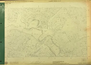
Map, Melbourne and Metropolitan Board of Works. Survey Division, MMBW, Yarra 2500 / 13.21. Central Greensborough, 1979_05
... creek or river names. Central Greensborough. Prominent streets: Main Street, Para Road, St Helena Road and Diamond Creek Road....creek or river names. Central Greensborough. Prominent streets: Main Street, Para Road, St Helena Road and Diamond Creek Road. mmbw melbourne and metropolitan board of works shire of diamond valley greensborough - maps MMBW Map in 1:2500 [scale] series. ...Melbourne and Metropolitan Board of Works. Yarra 2500 [base map]. 13-21, Parishes of Keelbundora 2856 and Nillumbik 3310, Municipality of Diamond Valley 257. Shows street names, easement sizes, lot numbers, lodged plan numbers, names of prominent features, contour values, creek or river names. Central Greensborough. Prominent streets: Main Street, Para Road, St Helena Road and Diamond Creek Road.MMBW Map in 1:2500 [scale] series. Cream parchment with green tape reinforcing on edges and punched holes on left edge.mmbw, melbourne and metropolitan board of works, shire of diamond valley, greensborough - maps -
 Eltham District Historical Society Inc
Book, Irene Turvey et al, Greensborough and Greenhills / words by Irene Turvey ; Drawings by Ron Reynolds, 1973
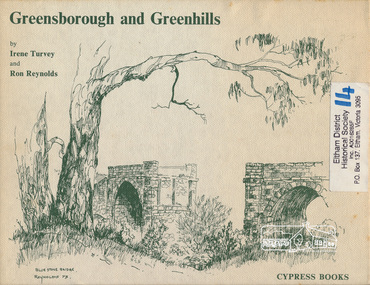
... Contents cover : Blue stone bridge, Introduction, House cnr Church and Hailes Street, House - 25 Hailes Street, Yandell Reserve, Greensborough Hotel, Lobb's Kiosk, House - 49 Grimshaw Street, View of Greensborough (from Delphin Crescent), Railway Station, Old Barn (near Greensborough Railway Station), Partington's Flat and River Valley, Rand Street Bridge, Lower Main Street, Greenbriar Nursery, Hitching rail, Ashmead - Dr Cordner's Home, Greensborough Primary School, House - cnr St Helena and Diamond Creek Raods, Sondermeyer's Hill, Methodist Church, Football Pavilion, Cemetery, St Katherine's Church, St. ...Contents cover : Blue stone bridge, Introduction, House cnr Church and Hailes Street, House - 25 Hailes Street, Yandell Reserve, Greensborough Hotel, Lobb's Kiosk, House - 49 Grimshaw Street, View of Greensborough (from Delphin Crescent), Railway Station, Old Barn (near Greensborough Railway Station), Partington's Flat and River Valley, Rand Street Bridge, Lower Main Street, Greenbriar Nursery, Hitching rail, Ashmead - Dr Cordner's Home, Greensborough Primary School, House - cnr St Helena and Diamond Creek Raods, Sondermeyer's Hill, Methodist Church, Football Pavilion, Cemetery, St Katherine's Church, St. ...Pen and ink sketches accompanied by appropriate text in double page spreads. Contents cover : Blue stone bridge, Introduction, House cnr Church and Hailes Street, House - 25 Hailes Street, Yandell Reserve, Greensborough Hotel, Lobb's Kiosk, House - 49 Grimshaw Street, View of Greensborough (from Delphin Crescent), Railway Station, Old Barn (near Greensborough Railway Station), Partington's Flat and River Valley, Rand Street Bridge, Lower Main Street, Greenbriar Nursery, Hitching rail, Ashmead - Dr Cordner's Home, Greensborough Primary School, House - cnr St Helena and Diamond Creek Raods, Sondermeyer's Hill, Methodist Church, Football Pavilion, Cemetery, St Katherine's Church, St. Helena, Civic Centre, Briar Hill Timber Mill, 24 River Street, Kelly's Garden Supplies, 158 Main Street, Old Swimming pool, 105 Main Street.Hardback; 62 p. : ill., map ; 19 x 25 cm.ISBN 0909807108 Signed by author and illustrator Two copiesgreenhills, greensborough -
 Eltham District Historical Society Inc
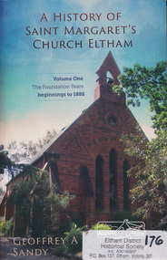
Book, Geoffrey A Sandy, A History of Saint Margaret's Church Eltham (Volume One) by Geoffrey A Sandy, 2014
... The early beginnings of the church included congregations at St Helena, Greensborough and Diamond Creek. People described in the book are listed as subjects in this description. ...The early beginnings of the church included congregations at St Helena, Greensborough and Diamond Creek. People described in the book are listed as subjects in this description. ...History of Saint Margaret's Church Eltham beginnings to 1888. Throughout this foundation period the community grew in numbers and influence within the developing district of Eltham. The minister's and lay readers appointed to Saint Margaret's are indentified and their contribution discussed. The significant events of the establishment of a temporary chuch and then a permanent church, the opening and closing of a denominational school, the construction of a parsonage, libraries and Sunday school are all examined. The key to the success of this faith community during its foundation years was the initiative and resourcefulness of its laypersons. - back cover. The early beginnings of the church included congregations at St Helena, Greensborough and Diamond Creek. People described in the book are listed as subjects in this description. The author Geoff Sandy mentions the following in the acknolwedgements on page iii: "Harry Gilham and Russell Yeoman of the Eltham District Historical Society willingly assisted me with locating records and images relevant to the scopeof this book".The first in a three volume set capturing a comprehensive rich history of the church and importantly its community for the first time.This volume discusses the pioneers of the Etham district who contributed not only to the foundation of the church but its wider thriving community and adds to the records of what we know about the early history.367 pages : colour illustrations ; 25 cm.[written inside front cover] Donated to the Eltham and District Historical Society on the occasion of the launch of "A History of Saint Margaret's Church Eltham" - 23 February 2014, Geoffrey A Sandysaint margaret's anglican church eltham, eltham, st helena church, dixon bertram, robert mackie, josiah hollis, andrew brown, arthur joseph pickering, john boyle gason, thomas cooper searle, henry dendy, william bravery andrew, charles symons wingrove, patrick alfred armstrong, patrick armstrong, john pearson, thomas hunniford, john gardner, thomas batt, isaac hill, william austin page, richard warren, john lindsay beale, henry stooke, john beale, charles hamilton, edwin willis maygar, william frederick ford, isaac briggs, david george clark, richard lowman, walter wippell, george knapman, benjamin oliver wallis, benjamin o. wallis, benjamin wallis, andrew logan, james rossiter, james thomas foster gilding, charles mash maplestone, george bird, george bird (1845-1921), charles hobart, e m bill, j c cole, william morris, francis flintoff, church of england, st margaret's anglican church, st margaret's anglican church eltham, st margaret's church, st margaret's church eltham, st margaret's church of england eltham, st margarets, st margarets anglican church, george stebbing, george stebbing builder -
 Eltham District Historical Society Inc
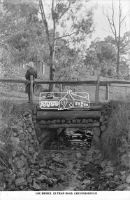
Photograph, The Rose Stereograph Company, Log Bridge, Eltham Road. Greensborough, c.1920
... creek...eltham road...greensborough...karingal road...karingal yallock...log bridge...sherbourne road...st helena...creek is possibly feeding into the Karingal Yalloc. The direction of the road based on shadows is northwest as is the Eltham Road to Greensborough (present day Sherbourne, Karingal and St Helena roads). ...creek is possibly feeding into the Karingal Yalloc. The direction of the road based on shadows is northwest as is the Eltham Road to Greensborough (present day Sherbourne, Karingal and St Helena roads). ...A woman stands at the end of a log bridge over a creek looking towards the south along the unsealed roadway. The sun illuminates her back. She is wearing a woollen knit beanie with edges rolled up, dark jacket and skirt, full length dark stockings and slip on dark leather shoes with raised heel, typical of the early 1920s. The creek is possibly feeding into the Karingal Yalloc. The direction of the road based on shadows is northwest as is the Eltham Road to Greensborough (present day Sherbourne, Karingal and St Helena roads). The creek is falling to the foreground so from south west to the north east, possibly feeding into the Karingal Yalloc, somewhere near presenet day Ramptons Road Reserve. This glass plate negative was used to manufacture postcards (1:1 printing) for commercial sale by the Rose Sterograph Company and its subsidiaries. George Rose founded the Rose Stereograph Company in 1880 and was joined by Herbert (Bert) Cutts in the early 20th Century. The pair formed a lifetime working partnership and strong personal friendship. Assisted by George’s two sons, Herbert George and Walter, and later by Neil Cutts, the Rose Stereograph Company continued its operations for more than 140 years. The company was initially built on stereographs, but as cinema took over and stereographs fell out of fashion, the Rose Stereograph Company developed Australia’s first commercially viable photographic postcard business. Specialising in postcards of iconic historical moments and significant landmarks, The Rose Stereograph Company became a staple of the Australian travel industry.This remarkable collection of glass plate negatives, transparencies, and postcards – arguably Australia’s most significant photography collection outside of public hands – has been passed down through the generations, surviving war, relocation, and the harsh Victorian climate. The historic Rose Stereograph collection is the culmination of George Rose’s dream of capturing and preserving precious moments in time and remains the legacy of the Rose and Cutts families. It is with great sadness that the Cutts family says goodbye to a collection that spans five generations and 140 years. The Cutts family understands that for these historically important pieces to rest with one family is to deny others the pleasure of their custodianship.Glass Plate Negative Size: 9.2 x 13.8 cmLog Bridge, Eltham Road, Greensborougheltham, postcard, travel, rose stereograph company, glass plate negative, creek, eltham road, greensborough, karingal road, karingal yallock, log bridge, sherbourne road, st helena road, women's fashion, rampton's road reserve, peter and elizabeth pidgeon collection -
 Eltham District Historical Society Inc
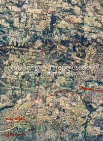
Photograph - Aerial Photograph, St Helena to Yarrambat, Vic, c.1995
... Frantal Hillmartin Road (Group) [Hillmartin Lane, Diamond Creek] Laminated; 46 x 34.5 cm St Helena to Yarrambat, Vic. Photograph Aerial Photograph ...Red annottions showing Nillumbik Shire Office in lower left extending to Diamond Creek centre right up to Yarrambat Marked: Submission 25/420 G. Frantal Hillmartin Road (Group) [Hillmartin Lane, Diamond Creek]aerial photo, diamond creek, eltham north, greensborough, hillmartin lane, nillumbik shire council offices -
 Eltham District Historical Society Inc
Document - Folder, North, Edley
... St Helena Road...St Faith's Anglican Church Montmorency...William Sapsford...Floods in Eltham...Joseph Benjamin North...Leon Lambert...Melbourne Symphony Orchestra...Karingal Drive...Meruka House...Alan Gardner...Lucinda Matilda North...Tralford E North...Camille D North...Montmorency Cricket Club...Diamond Creek...Marjorie North Tralford Norman Sherbourne Road Montmorency Looker Road Montmorency Briar Hill Montmorency Catholic Ladies College Merton Hall Melbourne Girls Grammar School Ivanhoe Girls Grammar School Wesley College Meruka Park St Helena Road St Faith's Anglican Church Montmorency William Sapsford Floods in Eltham Joseph Benjamin North Leon Lambert Melbourne Symphony Orchestra Karingal Drive Meruka House Alan Gardner Lucinda Matilda North Tralford E North Camille D North Montmorency Cricket Club Diamond Creek Eltham Railway Station Judge Book Village Fred Warne Edley North Caroline North Eltham Cemetery. ...Joseph Benjamin North was a well-known professional musician in Melbourne in late 1800 to mid 1900s, teaching music and playing in what became the Melbourne Symphony Orchestra. He married Lucinda Matilda and their children were Tralford E and Camille D. With friend Leon Lambert, North purchased 60 acres of land around Karingal Drive and Sherbourne Road and built two houses; they paid for a wooden bridge for access. North eventually sold his house to a family named Green but later the land was sold to the Shire of Eltham, and it is now known as Meruka Park, and the house, Meruka House; Alan Gardner named the park. After Lambert's death, his property was bought by Fred Warne. Edley North was born in 1835, and died 26 March 1923; he married Caroline North, born 1835, died 23 July 1922. Edley's family migrated from England in 1859, settling in Adelaide. He was granted an allotment of 221 acres on Phillip Island 1868-1870. on 7 April 1874 he travelled to Pine Lodge and later moved his wife and five children. He and Caroline later moved to a small farm, Willow Grove in Eltham, purchased between 1905 and 1910 (first mentioned in the rate book in 1908 as being a house and 10 acres on Susan Street, and would also have had frontage on Brougham Street); Their daughter Violet Alice inherited it; she married Walter J Dobson around 1921; he died on 25 March 1948 aged 77 and Violet on 4 January 1947. Willow Grove was later purchased by A George and P Audrey Hester April/May 1947. Edley, Caroline and Violet are all buried in Eltham Cemetery. Marjorie Mary North was born in 1909 ; the family travelled in a horse-drawn waggon from Fitzroy to spend weekends in their little holiday house in Sherbourne Road on 10 acres of land. In 1933, she married Tralford Norman whose parents owned 62 acres of land including Meruka Park. Marjorie and Tralford lived in Looker Road, Montmorency; she died 7 February 2003. Contents Newspaper article: "When life centred on a weekender", Diamond Valley News, 25 September 1984, memories of Montmorency of Marjorie North. Newspaper article: "Worse floods seem likely", Diamond Valley News, 25 September 1984, floods in Eltham Handwritten notes: Information by Marjorie North's about her grandmother, September 1989. Handwritten and typed transcript: "J. B. North", by Marjorie North, history of Joseph Benjamin North. Letter: From Monash University to Marjorie North, 15 November 1989, being unable to assist with her enquiry about the meaning of name [unspecified in the letter but possibly Meruka] Letter: June Stanton (nee Hester) to Eltham District Historical Society, 17 February 1993, seeking information on her great grandfather Edley North and wife Caroline. Christmas card [attached to letter from June Stanton]: Line drawing Eltham Primary School 1856, text history of school Letter: Eltham Historical Society to June Hester, 11 June 1993, providing information held by the Society. Letter: Nancy Chandler (nee Williamson) to Jo McCormick 18 March 2001, providing information about Edley and Carline North, her great grandparents. Email: Patsy Moppett to Eltham District Historical Society October 2010: A photograph of Edley and Caroline North found, wish to return it to family. Family tree: North/Dobson family. Death notice: Marjorie May North, died 7 February 2003.Newspaper clippings, A4 photocopies, etcmarjorie north, tralford norman, sherbourne road montmorency, looker road montmorency, briar hill, montmorency, catholic ladies college, merton hall, melbourne girls grammar school, ivanhoe girls grammar school, wesley college, meruka park, st helena road, st faith's anglican church montmorency, william sapsford, floods in eltham, joseph benjamin north, leon lambert, melbourne symphony orchestra, karingal drive, meruka house, alan gardner, lucinda matilda north, tralford e north, camille d north, montmorency cricket club, diamond creek, eltham railway station, judge book village, fred warne, edley north, caroline north, eltham cemetery., violet alice dobson (nee north), willow farm eltham, edley north family tree, walter john dobson family tree, nancy chandler (nee williamson), pine lodge, elijah north -
Eltham District Historical Society Inc
Document - Folder, Spence, Maxwell
... St Helena...Karingal Drive St Helena...Ted Walker...Weidligh...Roslind Miller...Graham Kennedy...Jimmy Beale...Leach Street St Helena...Plenty River...St Faith's Chrch of England Briar Hil...St Andrew's Church Briar Hill...St Francis Xavier Catholic Church Briar Hill...Herbie Wilson...Victoria Coffee Palace...Eltham Higher Elementary School...Kate McKenie...Diamond Creek...Maxwell Spence Briar Hill Montmorency Fernside Avenue Briar Hill Montmorency State School Were Street Montmorency Briar Hill State School Stan Stainsby Hee Alcock Ned Haughton Australian Paper Mills Lovitool Tomasetti baker of Greensborough Gladstone Avenue Briar Hill Beaconsfield Road Briar Hill Williams Road Briar Hill Ellis family Hillcrest playfield field Ben Barnett Bill Slater Colin Pugh Clifton Pugh St Helena Karingal Drive St Helena Ted Walker Weidligh Roslind Miller Graham Kennedy Jimmy Beale Leach Street St Helena Plenty River St Faith's Chrch of England Briar Hil St Andrew's Church Briar Hill St Francis Xavier Catholic Church Briar Hill Herbie Wilson Victoria Coffee Palace Eltham Higher Elementary School Kate McKenie Diamond Creek Frank Phillips Wingrove Park Bremner's Park Orrs Dam Pecks Dam Wal Scriver Montmorency Tennis Club Albert Price Hill Fred Balaam Greensborough RSL Joe Poulter Fairfield RSL Youth Club Bristcoes Hardware Merchants Montmorency RSL Jack Shallard Ted Weiland Petrie Park South Riding Ratepaers and Tenants Association Dr Keith Alexander Fred Durham Eltham Shire Council Meruka Park Max Watson Eric Harmer Spence Park Montmorency Mountain View Railway Bridge Montmrency Pre School Lower Plenty Fire Brigade Eltham High School Newspaper clippings, A4 photocopies, etc Spence, Maxwell Document Folder ...Max Spence came to Briar Hill as a child in 1923, and lived in the area for many years. Contents Typed and manuscript notes (2pp missing from MS), undated but ?c1990. "Spence: My Briar Hill and Montmorency." Reminiscences of Maxwell Spence of Briar Hill and Montmorency from 1923. Manuscript notes, AGM 1991, "Max Spence". Newspaper clippings, A4 photocopies, etcmaxwell spence, briar hill, montmorency, fernside avenue briar hill, montmorency state school, were street montmorency, briar hill state school, stan stainsby, hee alcock, ned haughton, australian paper mills, lovitool, tomasetti baker of greensborough, gladstone avenue briar hill, beaconsfield road briar hill, williams road briar hill, ellis family, hillcrest playfield field, ben barnett, bill slater, colin pugh, clifton pugh, st helena, karingal drive st helena, ted walker, weidligh, roslind miller, graham kennedy, jimmy beale, leach street st helena, plenty river, st faith's chrch of england briar hil, st andrew's church briar hill, st francis xavier catholic church briar hill, herbie wilson, victoria coffee palace, eltham higher elementary school, kate mckenie, diamond creek, frank phillips, wingrove park, bremner's park, orrs dam, pecks dam, wal scriver, montmorency tennis club, albert price hill, fred balaam, greensborough rsl, joe poulter, fairfield rsl youth club, bristcoes hardware merchants, montmorency rsl, jack shallard, ted weiland, petrie park, south riding ratepaers and tenants association, dr keith alexander, fred durham, eltham shire council, meruka park, max watson, eric harmer, spence park montmorency, mountain view railway bridge, montmrency pre school, lower plenty fire brigade, eltham high school -
Eltham District Historical Society Inc
Document - Folder, McLure, Mary
... St Helena...Rosanna Primary School...Diamond Creek...Mary McLure, Brian Hill, was honoured for her service to the community through volunteer rolls including The Old Colonists' Association of Victoria in St Helena, Rosanna Primary School, and Diamond Creek Craft Group. Roger Green, Lower Plenty, was honoured for his support of war veterans. ...Mary McLure, Brian Hill, was honoured for her service to the community through volunteer rolls including The Old Colonists' Association of Victoria in St Helena, Rosanna Primary School, and Diamond Creek Craft Group. Roger Green, Lower Plenty, was honoured for his support of war veterans. ...Mary McLure, Roger Green, Arthur Wilson, and Kevin Spiller were awarded Order of Australia Medals in the Queen's Birthday honours list. Mary McLure, Brian Hill, was honoured for her service to the community through volunteer rolls including The Old Colonists' Association of Victoria in St Helena, Rosanna Primary School, and Diamond Creek Craft Group. Roger Green, Lower Plenty, was honoured for his support of war veterans. Arthur Wilson, Greensborough, was honoured for his service to Australian Rules football. Kevin Spiller, Montmorency, was honoured for services to local government. Contents Newspaper article: "Our best get just rewards" Diamond Valley Leader, 19 June 2019, Lists local people who received an OAM in Queen's Birthday honours list. Newspaper clippings, A4 photocopies, etcmary mclure, roger green, arthur wilson, kevin spiller, the old colonists' association of victoria st helena, rosanna primary school, diamond creek craft group -
Eltham District Historical Society Inc
Document - Folder, Macmillan, Donald
... Creek Methodist Church...Malcolm MacMillan...Helena MacMillan nee Heatley...Ken MacMillan...Mic Webb...Hurstbridge Learning Co-Op...Hurstbridge Victoria...Cottlesbridge Victoria...St...Donald MacMillan Plenty River Victoria Captain Aneas McPherson Thomas Walker Morang Victoria Arthurs Creek Victoria Ann MacMillan Hazel Glen School Victoria South Yan Yean Victoria Mernda Victoria Arthurs Creek School Victoria Arthurs Creek Methodist Church Malcolm MacMillan Helena MacMillan nee Heatley Ken MacMillan Mic Webb Hurstbridge Learning Co-Op Hurstbridge Victoria Cottlesbridge Victoria St Andrews Victoria Newspaper clippings, A4 photocopies, etc Macmillan, Donald Document Folder ...Donald MacMillan (widower) with his six children eft Inverness, Scotland, in 1849, and worked as a shepherd on Plenty River property of Captain Aneas McPerson, under the manager Thomas Walker. MacMillan married again and son Hugh was born 1860, first of another six children. They lived at Morang but, in 1866, selected land at Arthurs Creek. Hugh and his sister Ann attended the Hazel Glen School. Later Hugh carried mail from South Yan Year (now Mernda) to Arthurs Creek School (also the post office); he was Sunday School teacher at the Arthurs Creek Methodist Church. Hugh married Helena Heatley from New Zealand who managed the farm after Hugh died, growing fruit and vegetables, carted by wagon to the Victoria Market. Their firstborn was Ken. Contents Newspaper article: "Donald MacMillan - a romantic", Diamond Valley News, 29 October 1985, pp30-31; history of MacMillan family. Newspaper article: "An alternative road to happiness", Diamond Valley News, 29 October 1985, p29; Mic Webb's travels and philosophy, now living at Hurstbridge.Newspaper clippings, A4 photocopies, etcdonald macmillan, plenty river victoria, captain aneas mcpherson, thomas walker, morang victoria, arthurs creek victoria, ann macmillan, hazel glen school victoria, south yan yean victoria, mernda victoria, arthurs creek school victoria, arthurs creek methodist church, malcolm macmillan, helena macmillan nee heatley, ken macmillan, mic webb, hurstbridge learning co-op, hurstbridge victoria, cottlesbridge victoria, st andrews victoria -
 Eltham District Historical Society Inc
Photograph - Digital Photograph, Marguerite Marshall, Wingrove Cottage, Main Road, Eltham, 8 June 2006
... St Helena. His grave is surrounded by those of family members including his wife, Katherine and two babies, Henry, 12 months and Isobella, 15 months, who died in the mid-1860s. Cottage ownership passed to his wife, then to daughter Caroline and then to daughter Bessie, a Melbourne University graduate and artist. During the Great Depression their brother Walter was the ratepayer. At one stage the Wingrove property extended to Metery Road and included a small creek...St Helena. His grave is surrounded by those of family members including his wife, Katherine and two babies, Henry, 12 months and Isobella, 15 months, who died in the mid-1860s. Cottage ownership passed to his wife, then to daughter Caroline and then to daughter Bessie, a Melbourne University graduate and artist. During the Great Depression their brother Walter was the ratepayer. At one stage the Wingrove property extended to Metery Road and included a small creek ...Wingrove Cottage built 1858-1859 of hand made bricks is historically significant for its long association with Charles Wingrove, a prominent figure in Victorian local government, as secretary to the Eltham District Road Board and Shire Council from 1858 to 1904, and Shire Engineer and Secretary to the Heidelberg Road Board. The cottage was used as the office of the Eltham District Road Board and Council for many years It is one of the Shire's oldest dwellings, and one of the few surviving 19th century buildings associated with early Eltham and located in the original Eltham Village Reserve. The symmetrical planting of a pair of Pencil Pines (not visible in photo) is also historically and aesthetically significant as characteristic of the early period of planting in the district and because they are a distinctive landscape feature. In October 2002 new owners demolished the outbuildings attached to the rear of the cottage. Community protest at the demolition resulted in Council issuing a Stop Work order. The owner was issued with a court order in September 2003 to develop a conservation management plan and restore the heritage listed property. The owner sold the property in 2005 to Cameron Construction in 2005 who undertook the restoration work. In 2007 a planning application to build two offices and seven dwellings at the rear of the property was ultimately rejected. The cottage is now the main office for Cameron Construction. Covered under Heritage Overlay, Nillumbik Planning Scheme. Published: Nillumbik Now and Then / Marguerite Marshall 2008; photographs Alan King with Marguerite Marshall.; p57 Wingrove Cottage on Main Road beside Eltham Primary School, is one of the Shire’s most important historical buildings and was central to local government for almost 50 years. The cottage was built in stages from 1858 to 1888 for Charles Symons Wingrove JP. He was the Eltham District Road Board’s first paid secretary and later the Shire Secretary when the board became the Eltham Shire Council. Wingrove held those positions, and that of engineer for a time, for 46 years. He was also one of the main figures in the Municipal Association of Victoria. As Eltham’s first paid municipal officer, Wingrove used one room in his 11 – (originally two) roomed home, as the office for the board then the council. Meetings were held there from the late 1850s (as well as at more central locations) until Wingrove’s retirement in 1904. The cottage is a rare example of a local government office occupying a Road Board /Shire Secretary’s purpose-designed house. The cottage is also significant because it is the oldest largely intact building from the original Eltham township reserve (south of Dalton Street).1 The township had its origins in the 1848 Nillumbik Parish Plan and was one of the state’s earliest township reserves. The rectangular house of handmade bricks, roofed with grey slate tiles and with a veranda encompassing three sides, is reminiscent of those in the central goldfields including Castlemaine. Its overhanging eaves and gables were unlike houses in Melbourne at the time. Wingrove, who was born in 1827, had been a gold digger and a road surveyor. Impossible to imagine in today’s world, Wingrove was also the Shire of Heidelberg’s secretary and engineer for part of the time that he was secretary in Eltham. Living next door to the primary school was a mixed blessing. Wingrove and his wife Katherine, who had ten children, sent their eight surviving children to the school. But they had occasional disputes with the school authorities when their cattle wandered into the schoolyard. Eltham showed Charles Wingrove its appreciation of his services by giving him two illuminated addresses, one after ten years and the other at retirement. Wingrove died in 1905 aged 76 and was buried in the St Katherine’s Church of England cemetery in St Helena. His grave is surrounded by those of family members including his wife, Katherine and two babies, Henry, 12 months and Isobella, 15 months, who died in the mid-1860s. Cottage ownership passed to his wife, then to daughter Caroline and then to daughter Bessie, a Melbourne University graduate and artist. During the Great Depression their brother Walter was the ratepayer. At one stage the Wingrove property extended to Metery Road and included a small creek. The family ran a small dairy and orchard, with associated farm buildings, which were later removed. In 1949 part of the property was compulsorily acquired by the Eltham Primary School, which infuriated owner Bessie Wingrove. She protested in a letter about this ‘monstrous act of unmitigated tyranny’.2 She was the last Wingrove to occupy the cottage and died in 1955. Wingrove descendants sold the house in 1974 and the property was subdivided. In the 1960s the Eltham Shire named the park opposite the cottage in Wingrove’s honour. The cottage has since had several owners including psychiatrist Dr Daniel Kahans, who practised there. In October 2002 late rear additions which had been substantially altered were demolished contrary to council planning controls. This caused a community outcry and resulted in legal proceedings against the owner. Fortunately the historical significance of the demolished section was not as great as the older front part of the building, which has been retained and was later restored.This collection of almost 130 photos about places and people within the Shire of Nillumbik, an urban and rural municipality in Melbourne's north, contributes to an understanding of the history of the Shire. Published in 2008 immediately prior to the Black Saturday bushfires of February 7, 2009, it documents sites that were impacted, and in some cases destroyed by the fires. It includes photographs taken especially for the publication, creating a unique time capsule representing the Shire in the early 21st century. It remains the most recent comprehenesive publication devoted to the Shire's history connecting local residents to the past. nillumbik now and then (marshall-king) collection, cameron construction, charles symons wingrove, eltham, eltham road district board, eltham shire council, main road, wingrove cottage -
 Eltham District Historical Society Inc
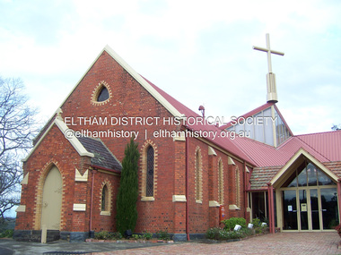
Photograph - Digital Photograph, Marguerite Marshall, St John's Anglican Church, Diamond Creek, 7 September 2008
... Creek Gold Mine, wiping out the major livelihood of most parishioners. However the church’s morale was lifted in 1916, when it received a bequest to build the red brick hall, from late parishioner and prominent leather manufacturer, George Pizzey. As prosperity grew, in 1924 the congregation separated from Greensborough, but they rejoined in the 1930s Depression. In the 1950s the wider population soared, impacting on St John’s, and it became a separate parish, becoming responsible for six churches at St Andrews, Hazel Glen, Hurstbridge, St Helena...Creek Gold Mine, wiping out the major livelihood of most parishioners. However the church’s morale was lifted in 1916, when it received a bequest to build the red brick hall, from late parishioner and prominent leather manufacturer, George Pizzey. As prosperity grew, in 1924 the congregation separated from Greensborough, but they rejoined in the 1930s Depression. In the 1950s the wider population soared, impacting on St John’s, and it became a separate parish, becoming responsible for six churches at St Andrews, Hazel Glen, Hurstbridge, St Helena ...The building was designed by Charles Maplestone of Heidelberg, son-in-law to Anthony Beale of St Helena. Maplestone was a prominent architect who came out to Australia with his family in 1852. The foundation stone was laid by Mrs Isabella Maplestone on 11th November 1867. The bricklayers for the church were George Stebbing, H Limmer, H Spicer and a Mr Timm while Thomas Day was the stonemason. Another three years were to pass before sufficient money could be raised for its completion. It was opened by Bishop Perry on 1st November, 1870. The church bell which hung under a tree for 50 years until it was incorporated in the parish hall was brought out from England and presented by Charles Orme. In 1916, the estate of George Martin Pizzey left sufficient money to build the red brick hall, which still stands today (2023) though in January 1969 the hall and bell tower were badly damaged by bushfire. Coincidentally the former home of benefactor, George Pizzey was destroyed in the same fire. Of particular significance are the interior and exterior of the church, the Sunday school and hall with emphasis on pre-World War I fabric (excluding the 1990s additions) and the three coloured glass windows currently suspended in the 1990s entry foyer. In 2011 further alterations were made to the front of the Church. The church is historically significant because it was the oldest public building in the former Diamond Valley Shire, is amongst the oldest buildings in the Shire of Nillumbik and is associated with the early settlement of the Diamond Creek district. The church is historically, socially and spiritually significant because it has been a place of worship for over 150 years and continues to be, an important meeting place in the Shire. The church is aesthetically significant for the three stained glass windows executed by the noted stained glass manufacturers, Ferguson & Urie, as well as the supporting coloured glass windows in the church. The Sunday school & parish hall is architecturally significant because the hall is a well executed and preserved example of the work of noted church architects, North & Williams. It is historically significant because it is connected with local parishioner and Melbourne industrialist, George Pizzey, who bequeathed funds for its construction. Covered under Heritage Overlay, Nillumbik Planning Scheme. National Estate Ntionl Trust of Australia (Victoria) Local significance Published: Nillumbik Now and Then / Marguerite Marshall 2008; photographs Alan King with Marguerite Marshall.; p85 St John’s Anglican Church stands like a beacon on the hill on Main Street, Diamond Creek. Today the church has a large congregation, but its early years were marked by a small congregation struggling to find enough money to survive. It was gold in Diamond Creek that resulted in the building of this National Trust registered property.1 This church is far removed from William Wilson’s humble barn (later the Bowling Green) where the first Anglican church services were conducted – probably the first in the district.2 In the mid 19th century services were infrequent as the Rev Francis Hales, travelling on horseback, also conducted services elsewhere, including at Heidelberg, Coburg, Kinglake, Arthurs Creek, St Andrews and Kangaroo Ground. In 1860 Diamond Creek came under the jurisdiction of the Eltham Parish. Until the mid 1860s the Diamond Creek settlement included only about 20 families who were struggling farmers. But this changed when gold was found in 1862. Then the township grew to 200 families, including miners, civil administration workers and shopkeepers. The resulting growth of Church of England adherents prompted them to petition the Government in 1866 for land to build a church. The area chosen, on which the original building still stands, was at the centre of the proposed township. Today church leaders believe that this conspicuous location is one of the reasons for its exceptional growth. Prominent architect Charles Maplestone designed the building as he did the Presbyterian Church at Kangaroo Ground. St John’s, which is still intact, was built in the Gothic Revival style with the traditional rectangular plan of a central nave and sanctuary at the end. It is typical of small churches built in Victoria at that time, with polychromatic hand-made bricks, a porch, diagonal buttresses and a slate roof.3 The church was officially opened by Lord Bishop Perry on November 1, 1870. But during the next 40 years, due to the varying fortunes of gold mining, the church struggled to remain viable. In 1909 it separated from the Eltham Parish to form a parish with Greensborough. Life became more difficult with the privations of World War One. Then disaster struck in 1915 when fire destroyed the Diamond Creek Gold Mine, wiping out the major livelihood of most parishioners. However the church’s morale was lifted in 1916, when it received a bequest to build the red brick hall, from late parishioner and prominent leather manufacturer, George Pizzey. As prosperity grew, in 1924 the congregation separated from Greensborough, but they rejoined in the 1930s Depression. In the 1950s the wider population soared, impacting on St John’s, and it became a separate parish, becoming responsible for six churches at St Andrews, Hazel Glen, Hurstbridge, St Helena and Yarrambat. As parishioner numbers outgrew the building, extensions were added in 1989 and then in 1993, blending in well with the original building. Church members have made a huge contribution to the local community. John Ryan was a Heidelberg Shire Councillor for 25 years from 1931, Mayor in 1939 and headed several local sporting and other organisations. His son Jock became a clergyman and a local historian heading the Nillumbik Historical Society. Another parishioner, Dr Ted Cordner, came to Diamond Creek in 1920. One of his sons Donald, who was a local doctor, won the Brownlow Medal, was President of the Melbourne Cricket Club and President of the Melbourne Grammar School Council. Roy ‘Monty’ Vale was a state Liberal MP and was related to May Vale, a member of the Heidelberg School of Artists.4 In the early 21st century St John’s Anglican Church is one of the fastest growing congregations in Melbourne. References: St Johns Anglican Church complex, Sunday School and Parish Hall 61 Main Street DIAMOND CREEK, NILLUMBIK SHIRE. (2023, June 7). Retrieved from https://vhd.heritagecouncil.vic.gov.au/places/64023 Diamond Creek, VIC. – St John’s Anglican (2023, June 7). Retrieved from https://www.churchhistories.net.au/church-catalog/diamond-creek-vic-st-johns-anglican This collection of almost 130 photos about places and people within the Shire of Nillumbik, an urban and rural municipality in Melbourne's north, contributes to an understanding of the history of the Shire. Published in 2008 immediately prior to the Black Saturday bushfires of February 7, 2009, it documents sites that were impacted, and in some cases destroyed by the fires. It includes photographs taken especially for the publication, creating a unique time capsule representing the Shire in the early 21st century. It remains the most recent comprehenesive publication devoted to the Shire's history connecting local residents to the past. nillumbik now and then (marshall-king) collection, st john's anglican church, diamond creek -
 Eltham District Historical Society Inc
Photograph - Digital Photograph, Alan King, Maroondah Aqueduct Siphon Bridge over the Plenty River, 26 January 2008
... It extends from the Maroondah Reservoir through Christmas Hills, Kangaroo Ground, Research, Eltham, St Helena and then previously wound west through Greensborough to Reservoir.3 Built by horse and manpower the aqueduct gravity fed 25 million gallons (113.6ML) of water a day to Melbourne along a gradient of one foot to the mile. It included 25 miles (41km) of open concrete and brick channel, six miles (10km) of tunnels, and nine miles (15km) of 14 inverted siphons of riveted wrought-iron across creeks. ...It extends from the Maroondah Reservoir through Christmas Hills, Kangaroo Ground, Research, Eltham, St Helena and then previously wound west through Greensborough to Reservoir.3 Built by horse and manpower the aqueduct gravity fed 25 million gallons (113.6ML) of water a day to Melbourne along a gradient of one foot to the mile. It included 25 miles (41km) of open concrete and brick channel, six miles (10km) of tunnels, and nine miles (15km) of 14 inverted siphons of riveted wrought-iron across creeks. ...Opened in 1891, the bridge formed part of the Maroondah Aqueduct carrying water from Watts River near Healesville to the reservoir at Preston where it joined Melbourne's metropolitan water system. Covered under Heritage Overlay, Nillumbik Planning Scheme. Published: Nillumbik Now and Then / Marguerite Marshall 2008; photographs Alan King with Marguerite Marshall.; p99 Built to supply thirsty Melbourne in the late 19th century, the siphon bridge spanning the Plenty River off Leischa Court, Greensborough, was part of an engineering masterpiece. Opened in 1891, the bridge formed part of the Maroondah Aqueduct carrying water from the Watts River near Healesville to the reservoir at Preston where it joined the metropolitan distribution system. A major link in Melbourne’s water supply, it also had a huge impact on communities, which mushroomed along its route. Named after the Aboriginal word for the area around the Maroondah Reservoir, the Maroondah Aqueduct was fully operational until the 1970s. Since the 1980s the land along parts of the aqueduct have been used for walking and bicycle riding, shaded in places by Monterey Pine trees planted to stabilise the surrounding ground. From 1857 the Yan Yean Reservoir supplied Melbourne’s water but the growing city needed additional catchments.1 In 1886 work began on a weir on the Watts River to enable the aqueduct to carry most of the river water 41 miles (66km) to Melbourne. The aqueduct, built by the Board of Works, is the oldest remaining aqueduct near Melbourne and was probably the first built with concrete.2 Although the aqueduct is now only used between the Maroondah and Sugarloaf Reservoirs, it can still be traced across the Shire. It extends from the Maroondah Reservoir through Christmas Hills, Kangaroo Ground, Research, Eltham, St Helena and then previously wound west through Greensborough to Reservoir.3 Built by horse and manpower the aqueduct gravity fed 25 million gallons (113.6ML) of water a day to Melbourne along a gradient of one foot to the mile. It included 25 miles (41km) of open concrete and brick channel, six miles (10km) of tunnels, and nine miles (15km) of 14 inverted siphons of riveted wrought-iron across creeks. Bricks for the aqueduct were made from clay found near the sites and remains of several kilns can still be found between Kangaroo Ground and Christmas Hills. Building the aqueduct transformed local communities. An abattoir was established at Christmas Hills. Grog shanties and labourers’ camps sprang up and local courts dealt with cases of ‘petty pilfering and boisterous behaviour’.4 The Kangaroo Ground school population jumped to 91, crammed into a room with one teacher. Miners who built the tunnels camped just north of Churinga in Greensborough – then called Tunnel Hill Camp – and adjacent to the Evelyn Arms Hotel. The miners’ high spirits were sometimes quenched in horse troughs or by a ‘welt under the ear and kick on the behind’ as the local constable calmed them down rather than lock them up.5 But the growing city of Melbourne needed more water, so the O’Shannassy catchment, east of Warburton, was added to the system in 1914. In 1920 work began on the present concrete Maroondah Dam one mile (1.6km) from the weir on the Watts River. The aqueduct capacity was thus doubled to 50 million gallons (227ML) a day.6 Intense land development threatened to pollute the open water supply, so channel sections were replaced with large pipes. In the late 1960s a large water main was built from the tunnel outlet at Research and extended through St Helena and Greensborough, so this section of the aqueduct was taken out of use. Long sections of the unused open channels in Greensborough and Bundoora were destroyed, but the old channel in Research and Eltham North remained largely intact. In the 1970s, the Sugarloaf Reservoir was constructed, inundating 445 hectares of land in Christmas Hills. Sugarloaf was officially opened in 1980 and serves as a water storage and treatment plant supplying Melbourne. In the early 1980s pipes replaced the section from Sugarloaf Reservoir to the tunnel entrance at Kangaroo Ground. The Research-Kangaroo Ground tunnel operates as part of the pipeline system.This collection of almost 130 photos about places and people within the Shire of Nillumbik, an urban and rural municipality in Melbourne's north, contributes to an understanding of the history of the Shire. Published in 2008 immediately prior to the Black Saturday bushfires of February 7, 2009, it documents sites that were impacted, and in some cases destroyed by the fires. It includes photographs taken especially for the publication, creating a unique time capsule representing the Shire in the early 21st century. It remains the most recent comprehenesive publication devoted to the Shire's history connecting local residents to the past. nillumbik now and then (marshall-king) collection, maroondah aqueduct, pipe bridge, siphon bridge -
 Greensborough Historical Society
Letter, Brian Blackburn to Faye Fort, 1942o
... Letter from Brian Blackburn to Faye Fort, reminiscing about his childhood in Greensborough living on the property 'Hillside' at 3 St Helena Road [on the Corner with Diamond Creek Road]....Greensborough Historical Society 34A Glenauburn Road Lower Plenty Lower Plenty melbourne Letter from Brian Blackburn to Faye Fort, reminiscing about his childhood in Greensborough living on the property 'Hillside' at 3 St Helena Road [on the Corner with Diamond Creek Road]. A personal memory of life in Greensborough, mid 20th century. greensborough faye fort brian blackburn Text of letter, typescript, 2 pages. ...Letter from Brian Blackburn to Faye Fort, reminiscing about his childhood in Greensborough living on the property 'Hillside' at 3 St Helena Road [on the Corner with Diamond Creek Road].A personal memory of life in Greensborough, mid 20th century.Text of letter, typescript, 2 pages.greensborough, faye fort, brian blackburn -
 Greensborough Historical Society
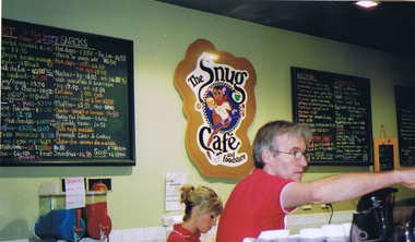
Photograph - Digital image, Frank Solomon, The Snug Cafe St Helena 1, 1990c
... St Helena Marketplace was the site of "The Snug". These photographs were taken by Frank Solomon and depict a cafe called The Snug, which is no longer operating. [Location information: Shop 10 St Helena Market Place Aqueduct Road Diamond Creek Vic 3089] ...St Helena Marketplace was the site of "The Snug". These photographs were taken by Frank Solomon and depict a cafe called The Snug, which is no longer operating. [Location information: Shop 10 St Helena Market Place Aqueduct Road Diamond Creek Vic 3089] the snug st helena marketplace st helena Digital copy of colour photograph The Snug Cafe St Helena 1 Photograph - Digital image Frank Solomon ...St Helena Marketplace was the site of "The Snug". These photographs were taken by Frank Solomon and depict a cafe called The Snug, which is no longer operating. [Location information: Shop 10 St Helena Market Place Aqueduct Road Diamond Creek Vic 3089] Digital copy of colour photographthe snug, st helena marketplace, st helena -
![Photograph - Digital image, House corner Diamond Creek and St Helena Roads [Greensborough], 02/05/2013](/media/collectors/4f729f5697f83e03086015b8/items/5729b8962162f108e8de2d43/item-media/5729b8f42162f108e8de30fe/item-fit-380x285.jpg?cb=6) Greensborough Historical Society
Greensborough Historical SocietyPhotograph - Digital image, House corner Diamond Creek and St Helena Roads [Greensborough], 02/05/2013
... House corner Diamond Creek and St Helena Roads [Greensborough]...st helena road greensborough...diamond creek...This photograph of the corner Diamond Creek and St Helena Roads was taken in 2013 to show changes over 40 years, based on Ron Reynold’s sketches in the 1973 publication 'Greensborough and Greenhills' published by Cypress Books. ...The house on the corner is the subject of one sketch in the book. greensborough and greenhills st helena road greensborough diamond creek road greensborough ron reynolds Digital copy of colour photograph. ...This photograph of the corner Diamond Creek and St Helena Roads was taken in 2013 to show changes over 40 years, based on Ron Reynold’s sketches in the 1973 publication 'Greensborough and Greenhills' published by Cypress Books. The house on the corner is the subject of one sketch in the book.Digital copy of colour photograph.greensborough and greenhills, st helena road greensborough, diamond creek road greensborough, ron reynolds