Showing 1378 items matching "station rd"
-
 Emerald Museum & Nobelius Heritage Park
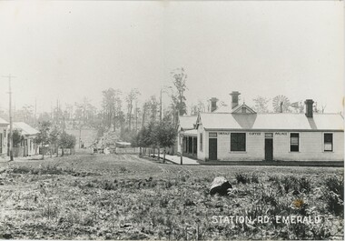
Photograph, Station Rd, Emerald, c. 1907
... Station Rd, Emerald...Bottom-right: "STATION RD. EMERALD" Building in the photograph: "EMERALD COFFEE PALACE"...In the background, the slope rises back up to a hill with fields and scattered trees. Station Rd, Emerald Photograph ...There are seven other copies of this photograph in our collection, mostly differing in the placement of the label and the cropping of the photograph. This is itself a copy of the original. One of these copies is also accessioned as VEMUP0456.2. This c. 1907 photograph was taken from the intersection of Beaconsfield Road (now Kilvington Drive) and Station Road (now Puffing Billy Place), looking towards Emerald Railway Station. It looks past the Emerald Coffee Palace, a significant establishment serving coffee, wine, and more - a room in the back was even used as a visiting doctor's surgery. The Coffee Palace was, at the time, owned by the O'Connor family and run by Mrs Greatorex. At this time it was relatively new - the second centre of Emerald, around Kilvington Drive, mostly materialised thanks to the location of the railway station. The location of the railway is visible, but from this angle the station and tracks are not visible. Note the posts in front of the Palace - used to tie horses in this time before cars became dominant. There are elevated wires visible running along the left side of the street, which resemble power lines but at this time are more likely to have instead been telegraph cables. This copy was framed in the donor's home after being gifted to him by its previous owner, who bought it from an op-shop in Melbourne.This photograph recounts the growth of Emerald's second town centre around the railway station.This item is a large, slightly yellowed, black and white copy of an older photograph. It depicts an unpaved street leading down a hill to a gate and fence, with several shops to either side. There is a lamp post on the street corner on the right, and a telegraph line running along the left side. In the background, the slope rises back up to a hill with fields and scattered trees.Bottom-right: "STATION RD. EMERALD" Building in the photograph: "EMERALD COFFEE PALACE"emerald coffee palace, emerald, 1900s, commerce -
 Sunshine and District Historical Society Incorporated
Photograph - H.V. McKay with the Sunshine Harvester Pipe Band at Rupertswood|Harrison's Farm at Tarneit (Werribee) with Frank, Tom & Joshua Harrison|Kororoit Creek in flood looking towards Parsons Horse Hair Factory in background|ICI aerial photograpth looking from the south of Tilburn Rd with Station Rd to the left|Photo of early 1890's house at 179 Morris Street Sunshine
... McKay with the Sunshine Harvester Pipe Band at Rupertswood|Harrison's Farm at Tarneit (Werribee) with Frank, Tom & Joshua Harrison|Kororoit Creek in flood looking towards Parsons Horse Hair Factory in background|ICI aerial photograpth looking from the south of Tilburn Rd with Station Rd to the left|Photo of early 1890's house at 179 Morris Street Sunshine...McKay with the Sunshine Harvester Pipe Band at Rupertswood Harrison's Farm at Tarnett (Werribee) with Frank, Tom & Joshua Harrison Kororoit Creek in flood looking towards Parsons Horsehair Factory in background ICI aerial photograph looking from the south of Tilburn Rd with Station Rd to the left Photo of early 1890's house at 179 Morris Street Sunshine...McKay with the Sunshine Harvester Pipe Band at Rupertswood Harrison's Farm at Tarnett (Werribee) with Frank, Tom & Joshua Harrison Kororoit Creek in flood looking towards Parsons Horsehair Factory in background ICI aerial photograph looking from the south of Tilburn Rd with Station Rd to the left Photo of early 1890's house at 179 Morris Street Sunshine Collection of photos donated to S&DHS by unknown Photograph H.V. ...H.V. McKay with the Sunshine Harvester Pipe Band at Rupertswood Harrison's Farm at Tarnett (Werribee) with Frank, Tom & Joshua Harrison Kororoit Creek in flood looking towards Parsons Horsehair Factory in background ICI aerial photograph looking from the south of Tilburn Rd with Station Rd to the left Photo of early 1890's house at 179 Morris Street Sunshineh.v. mckay pipe band, band -
 Emerald Museum & Nobelius Heritage Park
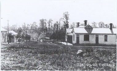
Photograph, Station Rd, Emerald, c. 1907
... Station Rd, Emerald...Bottom-right: "STATION RD. EMERALD" Building in the photograph: "EMERALD COFFEE PALACE" Reverse: "Coffee Palace was guest house / Note no gates this was before the railway Puffing Billy came through. / Note posts to tie horses to outside the palace. / O'Connors owned Coffee Palace. / Windmill in back of Palace - bore for water. 1889."...In the background, the slope rises back up to a hill with fields and scattered trees. Station Rd, Emerald Photograph ...There are seven other copies of this photograph in our collection, mostly differing in the placement of the label and the cropping of the photograph. This is itself a copy of the original. One of these copies is also accessioned as VEMUP0456.2. This c. 1907 photograph was taken from the intersection of Beaconsfield Road (now Kilvington Drive) and Station Road (now Puffing Billy Place), looking towards Emerald Railway Station. It looks past the Emerald Coffee Palace, a significant establishment serving coffee, wine, and more - a room in the back was even used as a visiting doctor's surgery. The Coffee Palace was, at the time, owned by the O'Connor family and run by Mrs Greatorex. At this time it was relatively new - the second centre of Emerald, around Kilvington Drive, mostly materialised thanks to the location of the railway station. The location of the railway is visible, but from this angle the station and tracks are not visible. While the annotation lists that the photograph was taken in 1889, the visibility of a gate (contra the annotation) and existence of this second town centre - which grew around the station - suggests that other sources lisitng 1907 are closer to accuracy. Note the posts in front of the Palace - used to tie horses in this time before cars became dominant. There are elevated wires visible running along the left side of the street, which resemble power lines but at this time are more likely to have instead been telegraph cables.This photograph recounts the growth of Emerald's second town centre around the railway station.This item is a black and white copy of an older photograph. It depicts an unpaved street leading down a hill to a gate and fence, with several shops to either side. There is a lamp post on the street corner on the right, and a telegraph line running along the left side. In the background, the slope rises back up to a hill with fields and scattered trees.Bottom-right: "STATION RD. EMERALD" Building in the photograph: "EMERALD COFFEE PALACE" Reverse: "Coffee Palace was guest house / Note no gates this was before the railway Puffing Billy came through. / Note posts to tie horses to outside the palace. / O'Connors owned Coffee Palace. / Windmill in back of Palace - bore for water. 1889."emerald coffee palace, emerald, commerce, 1900s -
 Sunshine and District Historical Society Incorporated
Photograph - Sunshine Fire Station McIntyre Rd Sunshine North Open Day 1990, The Advocate, 1990
... Sunshine Fire Station McIntyre Rd Sunshine North Open Day 1990...5672.01 - Sunshine Fire Station McIntyre Rd Open Day (Sun Adv 437.2) 1990 Photo 01.JPG 5672.02 - Sunshine Fire Station McIntyre Rd Open Day (Sun Adv 437.2) 1990 Photo 03.JPG 5672.03 - Sunshine Fire Station McIntyre Rd Open Day (Sun Adv 437.2) 1990 Photo 04.JPG 5672.04 - Sunshine Fire Station McIntyre Rd Open Day (Sun Adv 437.2) 1990 Photo 05.JPG 5672.05 - Sunshine Fire Station McIntyre Rd Open Day (Sun Adv 437.2) 1990 Photo 06.JPG 5672.06 - Sunshine Fire Station McIntyre Rd Open Day (Sun Adv 437.2) 1990 Photo 07.JPG 5672.07 - Sunshine Fire Station McIntyre Rd Open Day (Sun Adv 437.2) 1990 Photo 08.JPG 5672.08 - Sunshine Fire Station McIntyre Rd Open Day (Sun Adv 437.2) 1990 Photo 09.JPG 5672.09 - Sunshine Fire Station McIntyre Rd Open Day (Sun Adv 437.2) 1990 Photo 02.JPG ...McIntyre Road Sunshine North Sunshine Fire Station 5672.01 - Sunshine Fire Station McIntyre Rd Open Day (Sun Adv 437.2) 1990 Photo 01.JPG 5672.02 - Sunshine Fire Station McIntyre Rd Open Day (Sun Adv 437.2) 1990 Photo 03.JPG 5672.03 - Sunshine Fire Station McIntyre Rd Open Day (Sun Adv 437.2) 1990 Photo 04.JPG 5672.04 - Sunshine Fire Station McIntyre Rd Open Day (Sun Adv 437.2) 1990 Photo 05.JPG 5672.05 - Sunshine Fire Station McIntyre Rd Open Day (Sun Adv 437.2) 1990 Photo 06.JPG 5672.06 - Sunshine Fire Station McIntyre Rd Open Day (Sun Adv 437.2) 1990 Photo 07.JPG 5672.07 - Sunshine Fire Station McIntyre Rd Open Day (Sun Adv 437.2) 1990 Photo 08.JPG 5672.08 - Sunshine Fire Station McIntyre Rd Open Day (Sun Adv 437.2) 1990 Photo 09.JPG 5672.09 - Sunshine Fire Station McIntyre Rd Open Day (Sun Adv 437.2) 1990 Photo 02.JPG Scanned negatives of photographs taken by a Sunshine Advocate photographer. ...The Sunshine Fire Station (Station 44) at 30 McIntyre Road opened on 14 May 1990. This station replaced the earlier Hampshire Road / Hertford Road station, which had operated since 1927.5672.01 - Sunshine Fire Station McIntyre Rd Open Day (Sun Adv 437.2) 1990 Photo 01.JPG 5672.02 - Sunshine Fire Station McIntyre Rd Open Day (Sun Adv 437.2) 1990 Photo 03.JPG 5672.03 - Sunshine Fire Station McIntyre Rd Open Day (Sun Adv 437.2) 1990 Photo 04.JPG 5672.04 - Sunshine Fire Station McIntyre Rd Open Day (Sun Adv 437.2) 1990 Photo 05.JPG 5672.05 - Sunshine Fire Station McIntyre Rd Open Day (Sun Adv 437.2) 1990 Photo 06.JPG 5672.06 - Sunshine Fire Station McIntyre Rd Open Day (Sun Adv 437.2) 1990 Photo 07.JPG 5672.07 - Sunshine Fire Station McIntyre Rd Open Day (Sun Adv 437.2) 1990 Photo 08.JPG 5672.08 - Sunshine Fire Station McIntyre Rd Open Day (Sun Adv 437.2) 1990 Photo 09.JPG 5672.09 - Sunshine Fire Station McIntyre Rd Open Day (Sun Adv 437.2) 1990 Photo 02.JPG mcintyre road, sunshine north, sunshine fire station -
 Ringwood and District Historical Society
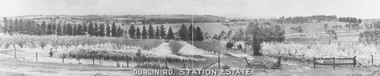
Photograph, Dublin Rd. Station Estate brochure. c.1923
... Dublin Rd. Station Estate brochure. c.1923....Printed on picture, "Dublin Rd. Station Estate" . Written below picture, "c1923"....Dublin Rd. Station Estate brochure. c.1923. Photograph ...Printed on picture, "Dublin Rd. Station Estate" . Written below picture, "c1923". -
 Sunshine and District Historical Society Incorporated
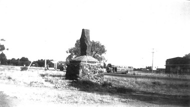
Photograph - Hume and Hovell Monument near Station Road and Ballarat Rd Intersection
... Hume and Hovell Monument near Station Road and Ballarat Rd Intersection...Copy of photograph of Hume and Hovell Monument near Station Road and Ballarat Rd. intersection. A3, b & w.....Rd. Hume and Hovell Monument Deer Park Copy of photograph of Hume and Hovell Monument near Station Road and Ballarat Rd. intersection. ...The site of the monument is in front of the former Deer Park State School. In 1991 the monument was moved a short distance to enable the widening of Ballarat Rd.hume and hovell, monument, deer park -
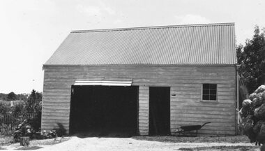
 Emerald Museum & Nobelius Heritage Park
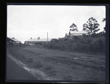
Negative - Image of Road Leading Towards Ranges Hotel and General Store, Baker & Rouse, Early 20th century
... ...Station Rd...This negative is of a muddy unmade road (now Station Rd) running alongside the Railway Station leading towards the Ranges Hotel, with the double-gabled General Store to the right. ...This negative is of a muddy unmade road (now Station Rd) running alongside the Railway Station leading towards the Ranges Hotel, with the double-gabled General Store to the right. ...This negative is one of a batch of ten images taken apparently around the same time at Gembrook c. early 20th century. This negative is of a muddy unmade road (now Station Rd) running alongside the Railway Station leading towards the Ranges Hotel, with the double-gabled General Store to the right. The hotel was built in 1902, two years after the Ferntree Gully to Gembrook railway was completed. It was an important social institution and tourist destination in Gembrook for over one hundred years until its destruction by fire in 2018. This negative shows two former iconic and historical buildings in Gembrook c. early 20th century.Black and white negative - landscape view - showing a road running alongside the railway station towards the Ranges Hotel, Gembrook c. early 20th century with the General Store visible on the right and railway gates in front of the hotel. This negative has been kept inside a packet which is not original.Handwritten on (not original) packet containing negative: 'Gembrook house & road'gembrook, ranges hotel, ferntree gully to gembrook railway, 1902, early 20th century, station rd, general store -
 Eltham District Historical Society Inc
Photograph (Item) - Negative, Ed Stuyfbergen, Food Plus Service Station, 180 Sherbourne Rd, Montmorency, 1988
... Food Plus Service Station, 180 Sherbourne Rd, Montmorency...Station...Montmorency...Scan - 35mm negative...Sherbourne Rd...It is a time capsule of life in the 1980s of this urban and rural municipality in Melbourne's north. shire of eltham archives Bicentennial Project Eltham Eltham Community Photographic Survey Series 35 Ed Stuyfbergen Film - Ilford FP4 Food Plus Service Station Montmorency Scan - 35mm negative Sherbourne Rd Black and white 35mm film strip - Ilford FP4 Food Plus Service Station, 180 Sherbourne Rd, Montmorency Photograph Negative Ed Stuyfbergen ...Ed Stuyfbergen 1988 Entrant No. 26 Ref: Series 34, Items 13, 14, 66-68 The images in this record were not selected for inclusion. SHIRE OF ELTHAM COMMUNITY PHOTOGRAPHIC SURVEY Photography is an artform which many of us practice, sometimes purely for artistic pursuit, sometimes to record the people and events in our lives. In 1988, as part of a local Bicentennial project, the Shire of Eltham conducted the Eltham Community Photographic Survey. Up to 100 entries were to be selected by a panel of photographers for entry into the Eltham Photographic Survey Exhibition. Entries had to be submitted by May 13, 1988. Entrants whose images were selected for the exhibition were contacted and requested to further submit an entry form providing entrant’s name, area of residence, age, and proposed captions. These details were then used to produce labels for the exhibition mounts. Where negatives had not been supplied, these were requested to support the display of printed enlargements mounted on 10” x 8” cardboard. The mounted prints were made available post exhibition for sale at $8.50 each for colour prints and $7.00 for B&W prints. Residents in the Shire were invited to collect a free roll of film and take a photograph of what they either liked or did not like about the area. A total of 160 entrants submitted multiple entries for the exhibition. Of those selected for exhibition, entrants ranged in age from 9 to 70 years. All custom colour and black and white printing for the exhibition was completed by Wattle Studios of Eltham. The Eltham Photographic Survey was jointly auspiced by the Shire of Eltham and Wattle Studios, of 953 Main Road, Eltham. The project was greatly assisted by: • David McRitchie, Media Studies Lecturer Victoria College, Rusden Campus. • Ian and Annette Toohill of Wattle Studios • Tracy Naughton, Eltham Community Arts Officer • Neville Emerson Pty. Ltd. • Superior Press, Eltham • Kodak Australasia Pty. Ltd. • Agfa Gevaert Ltd. • Townsend Colourtech Pty. Ltd. • The Australian Bicentennial Authority • Eleanor Bowers, Secretary, Eltham Arts Council The exhibition was placed on display in the Woolworths Arcade, Eltham between Monday June 6th and Saturday June 11, 1988. It was also intended to hold the exhibition at a venue in the Shire’s North Riding from Monday, June 20 to Friday June 24. It was then displayed at the Were Street Theatre, Montmorency from Friday, June 24 to Thursday, July 7. Series 34: Eltham Community Photographic Survey 1988 - Prints & Documentation Series consists of 117 photographs of Shire scenes taken by members of the community. Items I - 41 are larger photographs mounted on card, which were exhibited. Items 42 - 117 are unmounted copies, alternative takes and other entries. Corresponding negatives contained in Series 35: Eltham Community Photographic Survey 1988 – Negatives which consists of 267 colour and B&W negatives and one colour slide of Shire scenes taken by members of the community. The negatives are arranged by the entrant number of the photographer. The Eltham Community Photographic Survey collection is significant to the local community as it was curated by the local community - ordinary people of all ages - representing what they liked and did not like in the area where they lived. It represents an unfiltered representation of the Shire of Eltham as it was in 1988. It also represents one of many projects as part of the national programme of events and celebrations to commemorate the bicentenary. It is a time capsule of life in the 1980s of this urban and rural municipality in Melbourne's north. shire of eltham archives, bicentennial project, eltham, eltham community photographic survey, series 35, ed stuyfbergen, film - ilford fp4, food plus service station, montmorency, scan - 35mm negative, sherbourne rd -
 Ringwood and District Historical Society
Photograph, Stables at old Police Station, 32 Mt. Dandenong Rd. built 1888
... Stables at old Police Station, 32 Mt. Dandenong Rd. built 1888....Written on rear of backing sheet, "Stables at old Police Station, 32 Mt. Dandenong Rd. 1888....Stables at old Police Station, 32 Mt. Dandenong Rd. built 1888. Photograph ...Black and white photograph of weatherboard structure with iron roof.Written on rear of backing sheet, "Stables at old Police Station, 32 Mt. Dandenong Rd. 1888. -
 Ringwood and District Historical Society
Photograph, Station entrance and Whitehorse Rd. Ringwood 1984
... Station entrance and Whitehorse Rd. Ringwood 1984...Written on back of photograph, "Station entrance and Whitehorse Rd. 1984", although station itself is not in photograph....Station entrance and Whitehorse Rd. Ringwood 1984 Photograph ...Written on back of photograph, "Station entrance and Whitehorse Rd. 1984", although station itself is not in photograph. -
 Sunshine and District Historical Society Incorporated
Photograph - I.C.I Deer Park aerial view, n.d
... Aerial view of the I.C.I Deer Park factory site showing Station Rd & Tilburn Road (formerly Private Rd) at the bottom of picture....ICI Ballarat Road Deer Park Aerial Photograph Aerial view of the I.C.I Deer Park factory site showing Station Rd & Tilburn Road (formerly Private Rd) at the bottom of picture. ...ici, ballarat road, deer park, aerial photograph -
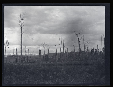 Emerald Museum & Nobelius Heritage Park
Negative - Image of The Railway Line, Baker & Rouse, Early 20th century
... ...Station Rd...Gembrook timber industry Railway 1900 early 20th century Station Rd Handwritten on (not original) packet containing negative: 'Railway line & dead trees /Gembrook' Black and white negative - landscape view - of the railway line at Gembrook. ...This negative is one of a batch of ten images taken apparently around the same time at Gembrook c. early 20th century. This one is of the Ferntree Gully to Gembrook railway line, which was completed in December 1900. The view looks northwards to the hills from probably present-day Station Road. This stark image of bare landscape with dead trees recalls both the early timber industry in Gembrook and the practice of wide-spread clearing of land for farming use.Black and white negative - landscape view - of the railway line at Gembrook. The railway is in the foreground. The landscape is bare apart from dead and ringbarked trees. Negative has been kept inside a packet which is not original.Handwritten on (not original) packet containing negative: 'Railway line & dead trees /Gembrook'gembrook, timber industry, railway, 1900, early 20th century, station rd -
 Sunshine and District Historical Society Incorporated
Photograph - Deer Park Photographs 2020, John Alchin, 2020
... 5610.01 - Ballarat Rd - ICI Building 28th March 2020 Photo 01.JPG 5610.02 - Ballarat Rd - ICI Building 28th March 2020 Photo 02.JPG 5610.03 - Ballarat Rd - ICI Gates 28th March 2020 Photo 01.JPG 5610.04 - Ballarat Rd - ICI Gates 28th March 2020 Photo 02.JPG 5610.05 - Ballarat Rd - ICI Main Entrance 28th March 2020.JPG 5610.06 - Ballarat Rd 760 Deer Park - Deer Park Hotel.JPG 5610.07 - Ballarat Rd Deer Park - ICI Old Resident Grounds 28th March 2020 Photo 01.JPG 5610.08 - Blue Trio The Hunt Club Ballarat Rd Deer Park Photo 01.JPG 5610.09 - Blue Trio The Hunt Club Ballarat Rd Deer Park Photo 02.JPG 5610.10 - Deer Park Hume And Hovell Monument 2nd April 2020 Photo 04.JPG 5610.11 - Deer Park Hume And Hovell Monument 2nd April 2020 Photo 05.JPG 5610.12 - Deer Park Hume And Hovell Monument 2nd April 2020 Photo 08.JPG 5610.13 - Deer Park State School 2nd April 2020 Photo 02.JPG 5610.14 - Deer Park State School 2nd April 2020 Photo 04.JPG 5610.15 - John McLeod Reserve 2020 Photo 02.JPG 5610.16 - Kororoit Creek Deer Park 2nd April 2020 Photo 01.JPG 5610.17 - Kororoit Creek Deer Park 2nd April 2020 Photo 04.JPG 5610.18 - Old Braybrook Shire Office Photo 01.JPG 5610.19 - Station Rd 50 Deer Park - Deer Park Hall.JPG 5610.20 - Station Rd 106 Deer Park - Covid Testing 2020.JPG 5610.21 - Station Rd Bridge over the Kororoit Creek 2nd April 2020 Photo 02.JPG 5610.22 - Station Rd Bridge over the Kororoit Creek 2nd April 2020 Photo 03.JPG 5610.23 - Station Rd Deer Park - Leathercloth Factory.JPG 5610.24 - Station Rd Deer Park - Sassella Park 2nd August 2020 Photo 01.JPG 5610.25 - Station Rd Deer Park - Sassella Park 2nd August 2020 Photo 14.JPG 5610.26 - Station Rd Deer Park - Sassella Park 2nd August 2020 Photo 15.JPG 5610.27 - Station Rd Deer Park - Sassella Park 2nd August 2020 Photo 16.JPG 5610.28 - Station Rd Deer Park - Sassella Park Deer Park Photo 01.JPG 5610.29 - Station Rd Deer Park - Sassella Park Deer Park Photo 02.JPG 5610.30 - Station Rd Deer Park - Vic Weaver Platation 2nd April 2020 Photo 01.JPG 5610.31 -Station Rd Deer Park - Vic Weaver Platation 2nd April 2020 Photo 03.JPG 5610.32 -The Hunt Club Ballarat Rd Deer Park Photo 01.JPG 5610.33 -The Hunt Club Ballarat Rd Deer Park Photo 02.JPG 5610.34 -The Hunt Club Ballarat Rd Deer Park Photo 05.JPG 5610.35 -The Hunt Club Ballarat Rd Deer Park Photo 06.JPG 5610.36 -The Hunt Club Ballarat Rd Deer Park Photo 08.JPG 5610.37 -Station Rd Deer Park - Sassella Park COVID 2nd August 2020 Photo 08.JPG 5610.38 -Station Rd Deer Park - Sassella Park COVID 2nd August 2020 Photo 11.JPG 5610.39 -Station Rd Deer Park - Sassella Park COVID 2nd August 2020 Photo 12.JPG 5610.40 -Station Rd Deer Park - Sassella Park COVID 2nd August 2020 Photo 13.JPG ...Deer Park Ballarat Road Station Road ICI Deer Park Hotel The Hunt Club And Community Arts Centre The Hunt Club Hume And Hovell Deer Park State School John McLeod Reserve Kororoit Creek Old Braybrook Shire Office Deer Park Hall COVID Leathercloth Factory Sassella Park Vic Weaver Platation 5610.01 - Ballarat Rd - ICI Building 28th March 2020 Photo 01.JPG 5610.02 - Ballarat Rd - ICI Building 28th March 2020 Photo 02.JPG 5610.03 - Ballarat Rd - ICI Gates 28th March 2020 Photo 01.JPG 5610.04 - Ballarat Rd - ICI Gates 28th March 2020 Photo 02.JPG 5610.05 - Ballarat Rd - ICI Main Entrance 28th March 2020.JPG 5610.06 - Ballarat Rd 760 Deer Park - Deer Park Hotel.JPG 5610.07 - Ballarat Rd Deer Park - ICI Old Resident Grounds 28th March 2020 Photo 01.JPG 5610.08 - Blue Trio The Hunt Club Ballarat Rd Deer Park Photo 01.JPG 5610.09 - Blue Trio The Hunt Club Ballarat Rd Deer Park Photo 02.JPG 5610.10 - Deer Park Hume And Hovell Monument 2nd April 2020 Photo 04.JPG 5610.11 - Deer Park Hume And Hovell Monument 2nd April 2020 Photo 05.JPG 5610.12 - Deer Park Hume And Hovell Monument 2nd April 2020 Photo 08.JPG 5610.13 - Deer Park State School 2nd April 2020 Photo 02.JPG 5610.14 - Deer Park State School 2nd April 2020 Photo 04.JPG 5610.15 - John McLeod Reserve 2020 Photo 02.JPG 5610.16 - Kororoit Creek Deer Park 2nd April 2020 Photo 01.JPG 5610.17 - Kororoit Creek Deer Park 2nd April 2020 Photo 04.JPG 5610.18 - Old Braybrook Shire Office Photo 01.JPG 5610.19 - Station Rd 50 Deer Park - Deer Park Hall.JPG 5610.20 - Station Rd 106 Deer Park - Covid Testing 2020.JPG 5610.21 - Station Rd Bridge over the Kororoit Creek 2nd April 2020 Photo 02.JPG 5610.22 - Station Rd Bridge over the Kororoit Creek 2nd April 2020 Photo 03.JPG 5610.23 - Station Rd Deer Park - Leathercloth Factory.JPG 5610.24 - Station Rd Deer Park - Sassella Park 2nd August 2020 Photo 01.JPG 5610.25 - Station Rd Deer Park - Sassella Park 2nd August 2020 Photo 14.JPG 5610.26 - Station Rd Deer Park - Sassella Park 2nd August 2020 Photo 15.JPG 5610.27 - Station Rd Deer Park - Sassella Park 2nd August 2020 Photo 16.JPG 5610.28 - Station Rd Deer Park - Sassella Park Deer Park Photo 01.JPG 5610.29 - Station Rd Deer Park - Sassella Park Deer Park Photo 02.JPG 5610.30 - Station Rd Deer Park - Vic Weaver Platation 2nd April 2020 Photo 01.JPG 5610.31 -Station Rd Deer Park - Vic Weaver Platation 2nd April 2020 Photo 03.JPG 5610.32 -The Hunt Club Ballarat Rd Deer Park Photo 01.JPG 5610.33 -The Hunt Club Ballarat Rd Deer Park Photo 02.JPG 5610.34 -The Hunt Club Ballarat Rd Deer Park Photo 05.JPG 5610.35 -The Hunt Club Ballarat Rd Deer Park Photo 06.JPG 5610.36 -The Hunt Club Ballarat Rd Deer Park Photo 08.JPG 5610.37 -Station Rd Deer Park - Sassella Park COVID 2nd August 2020 Photo 08.JPG 5610.38 -Station Rd Deer Park - Sassella Park COVID 2nd August 2020 Photo 11.JPG 5610.39 -Station Rd Deer Park - Sassella Park COVID 2nd August 2020 Photo 12.JPG 5610.40 -Station Rd Deer Park - Sassella Park COVID 2nd August 2020 Photo 13.JPG Collection of digital photographs Photograph Deer Park Photographs 2020 John Alchin ...These photographs provide a visual record of assorted buildings, street views, and notable locations throughout Deer Park in 2020 including the COVID 19 lockdownsThis photograph collection documents Deer Park in 2020.5610.01 - Ballarat Rd - ICI Building 28th March 2020 Photo 01.JPG 5610.02 - Ballarat Rd - ICI Building 28th March 2020 Photo 02.JPG 5610.03 - Ballarat Rd - ICI Gates 28th March 2020 Photo 01.JPG 5610.04 - Ballarat Rd - ICI Gates 28th March 2020 Photo 02.JPG 5610.05 - Ballarat Rd - ICI Main Entrance 28th March 2020.JPG 5610.06 - Ballarat Rd 760 Deer Park - Deer Park Hotel.JPG 5610.07 - Ballarat Rd Deer Park - ICI Old Resident Grounds 28th March 2020 Photo 01.JPG 5610.08 - Blue Trio The Hunt Club Ballarat Rd Deer Park Photo 01.JPG 5610.09 - Blue Trio The Hunt Club Ballarat Rd Deer Park Photo 02.JPG 5610.10 - Deer Park Hume And Hovell Monument 2nd April 2020 Photo 04.JPG 5610.11 - Deer Park Hume And Hovell Monument 2nd April 2020 Photo 05.JPG 5610.12 - Deer Park Hume And Hovell Monument 2nd April 2020 Photo 08.JPG 5610.13 - Deer Park State School 2nd April 2020 Photo 02.JPG 5610.14 - Deer Park State School 2nd April 2020 Photo 04.JPG 5610.15 - John McLeod Reserve 2020 Photo 02.JPG 5610.16 - Kororoit Creek Deer Park 2nd April 2020 Photo 01.JPG 5610.17 - Kororoit Creek Deer Park 2nd April 2020 Photo 04.JPG 5610.18 - Old Braybrook Shire Office Photo 01.JPG 5610.19 - Station Rd 50 Deer Park - Deer Park Hall.JPG 5610.20 - Station Rd 106 Deer Park - Covid Testing 2020.JPG 5610.21 - Station Rd Bridge over the Kororoit Creek 2nd April 2020 Photo 02.JPG 5610.22 - Station Rd Bridge over the Kororoit Creek 2nd April 2020 Photo 03.JPG 5610.23 - Station Rd Deer Park - Leathercloth Factory.JPG 5610.24 - Station Rd Deer Park - Sassella Park 2nd August 2020 Photo 01.JPG 5610.25 - Station Rd Deer Park - Sassella Park 2nd August 2020 Photo 14.JPG 5610.26 - Station Rd Deer Park - Sassella Park 2nd August 2020 Photo 15.JPG 5610.27 - Station Rd Deer Park - Sassella Park 2nd August 2020 Photo 16.JPG 5610.28 - Station Rd Deer Park - Sassella Park Deer Park Photo 01.JPG 5610.29 - Station Rd Deer Park - Sassella Park Deer Park Photo 02.JPG 5610.30 - Station Rd Deer Park - Vic Weaver Platation 2nd April 2020 Photo 01.JPG 5610.31 -Station Rd Deer Park - Vic Weaver Platation 2nd April 2020 Photo 03.JPG 5610.32 -The Hunt Club Ballarat Rd Deer Park Photo 01.JPG 5610.33 -The Hunt Club Ballarat Rd Deer Park Photo 02.JPG 5610.34 -The Hunt Club Ballarat Rd Deer Park Photo 05.JPG 5610.35 -The Hunt Club Ballarat Rd Deer Park Photo 06.JPG 5610.36 -The Hunt Club Ballarat Rd Deer Park Photo 08.JPG 5610.37 -Station Rd Deer Park - Sassella Park COVID 2nd August 2020 Photo 08.JPG 5610.38 -Station Rd Deer Park - Sassella Park COVID 2nd August 2020 Photo 11.JPG 5610.39 -Station Rd Deer Park - Sassella Park COVID 2nd August 2020 Photo 12.JPG 5610.40 -Station Rd Deer Park - Sassella Park COVID 2nd August 2020 Photo 13.JPG deer park, ballarat road, station road, ici, deer park hotel, the hunt club and community arts centre, the hunt club, hume and hovell, deer park state school, john mcleod reserve, kororoit creek, old braybrook shire office, deer park hall, covid, leathercloth factory, sassella park, vic weaver platation -
 Sunshine and District Historical Society Incorporated
Photograph - Deer Park Photographs 2021, John Alchin, 2021
... John Anglican Church Gates 2021 Photo 01.JPG 5653.27 - Station Rd 51 Deer Park 2021 Photo 01.JPG 5653.28 - Station Rd 75 Deer Park - Thai's Hairdressing Salon 2021 Photo 01.JPG 5653.29 - Station Rd 85 And 85A Deer Park - Shop 2021 Photo 01.JPG 5653.30 - Station Rd 93 Deer Park 2021 Photo 01.JPG 5653.31 - Station Rd 100 - 104 Deer Park - Medical Centre And Chemist 2021 Photo 01.JPG 5653.32 - Steel Works Glencairn Ave 2021 Photo 01.JPG 5653.33 - The Hunt Club Main Hall Way 2021 Photo 01.JPG 5653.34 - The Hunt Club Back Stained Glass Window 2021 Photo 10.JPG 5653.35 - The Hunt Club Balcony 2021 Photo 15 5653.36 - The Hunt Club Art Gallery 2021 Photo 17.JPG...John Anglican Church Gates 2021 Photo 01.JPG 5653.27 - Station Rd 51 Deer Park 2021 Photo 01.JPG 5653.28 - Station Rd 75 Deer Park - Thai's Hairdressing Salon 2021 Photo 01.JPG 5653.29 - Station Rd 85 And 85A Deer Park - Shop 2021 Photo 01.JPG 5653.30 - Station Rd 93 Deer Park 2021 Photo 01.JPG 5653.31 - Station Rd 100 - 104 Deer Park - Medical Centre And Chemist 2021 Photo 01.JPG 5653.32 - Steel Works Glencairn Ave 2021 Photo 01.JPG 5653.33 - The Hunt Club Main Hall Way 2021 Photo 01.JPG 5653.34 - The Hunt Club Back Stained Glass Window 2021 Photo 10.JPG 5653.35 - The Hunt Club Balcony 2021 Photo 15 5653.36 - The Hunt Club Art Gallery 2021 Photo 17.JPG Collection of digital photographs Photograph Deer Park Photographs 2021 John Alchin ...These photographs provide a visual record of assorted buildings, street views, and notable locations throughout Deer Park in 2021.This photograph collection documents Deer Park in 2021.5653.01 - Bon Thomas Reserve 2021 Photo 04.JPG 5653.02 - Bon Thomas Reserve 2021 Photo 01.JPG 5653.03 - Deer Park Avenue of Honour Ballarat Rd 2021 Photo 01.JPG 5653.04 - Deer Park Club 2021 Photo 02.JPG 5653.05 - Deer Park Club 2021 Photo 04.JPG 5653.06 - Deer Park Fire Station 782 Ballarat Rd Deer Park 2021 Photo 01.JPG 5653.07 - Deer Park Football Club Rooms 2021 Photo 02.JPG 5653.08 - Deer Park Football Club Rooms 2021 Photo 04.JPG 5653.09 - Deer Park Hall Station Rd Deer Park 2021 Photo 01.JPG 5653.10 - Deer Park Play Group Centre Millbank Drive Deer Park 2021 Photo 01.JPG 5653.11 - Deer Park Post Office Ballarat Rd 2021 Photo 01.JPG 5653.12 - Deer Park Railway Station 2021 Photo 01.JPG 5653.13 - Dumfries St 73 - 77 Deer Park - Shops 2021 Photo 02.JPG 5653.14 - Dumfries St 73 - 77 Deer Park - Shops 2021 Photo 03.JPG 5653.15 - John McLeod Reserve WW2 Air Raid Shelter 2021 Photo 06.JPG 5653.16 - Leathercloth Factory Station Rd Deer Park 2021 Photo 01.JPG 5653.17 - Opie's Farm Deer Park 2021 Photo 01.JPG 5653.18 - Opie's Farm Deer Park 2021 Photo 03.JPG 5653.19 - Opie's Farm Deer Park 2021 Photo 12.JPG 5653.20 - Opie's Farm Deer Park 2021 Photo 05.JPG 5653.21 - Opie's Farm Deer Park 2021 Photo 09.JPG 5653.22 - Opie's Farm Deer Park 2021 Photo 15.JPG 5653.23 - Porter Crt 1 Deer Park - Shops 2021 Photo 01.JPG 5653.24 - Robert Bruce Reserve Deer Park 2021 Photo 02.JPG 5653.25 - Sassella Park Station Rd - Significant Tree Sugar Gum 2021 Photo 01.JPG 5653.26 - St. John Anglican Church Gates 2021 Photo 01.JPG 5653.27 - Station Rd 51 Deer Park 2021 Photo 01.JPG 5653.28 - Station Rd 75 Deer Park - Thai's Hairdressing Salon 2021 Photo 01.JPG 5653.29 - Station Rd 85 And 85A Deer Park - Shop 2021 Photo 01.JPG 5653.30 - Station Rd 93 Deer Park 2021 Photo 01.JPG 5653.31 - Station Rd 100 - 104 Deer Park - Medical Centre And Chemist 2021 Photo 01.JPG 5653.32 - Steel Works Glencairn Ave 2021 Photo 01.JPG 5653.33 - The Hunt Club Main Hall Way 2021 Photo 01.JPG 5653.34 - The Hunt Club Back Stained Glass Window 2021 Photo 10.JPG 5653.35 - The Hunt Club Balcony 2021 Photo 15 5653.36 - The Hunt Club Art Gallery 2021 Photo 17.JPGdeer park, bon thomas reserve, ballarat road, deer park club, deer park fire station, deer park football club, station road, deer park hall, millbank drive, deer park play group, deer park post office, deer park railway station, dumfries street, john mcleod reserve, air raid shelter, leathercloth factory, opie's farm, porter court, robert bruce reserve, sassella park, st. john anglican church, the hunt club, deer park medical centre, deer park avenue of honour -
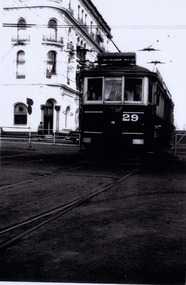 St Kilda Historical Society
Print, Railway tram, c. 1958
... Railway tram at St Kilda Station. St Kilda rd 29....St Kilda Historical Society St Kilda Branch Library 150 Carlisle Street St Kilda melbourne Railway tram at St Kilda Station. St Kilda rd 29. laminated black and white photograph (2 identical) Railway tram Print ...laminated black and white photograph (2 identical)Railway tram at St Kilda Station. St Kilda rd 29. -
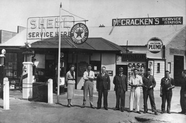 Stawell Historical Society Inc
Photograph, McCracken's Service Station
... B/W photo of McCracken's Shell Service Station Cnr Main Rd and Barnes Street with staff out front. 1950's ...Transport B/W photo of McCracken's Shell Service Station Cnr Main Rd and Barnes Street with staff out front. 1950's McCracken's Service Station Photograph ...Includes names L/R L McCracken, K McCracken, Caltex Rep, M White, R Walton, D Pickering, J Eggington.B/W photo of McCracken's Shell Service Station Cnr Main Rd and Barnes Street with staff out front. 1950's transport -
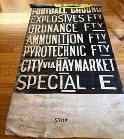 Ballarat Tramway Museum
Functional object - Destination Roll, Melbourne and Metropolitan Tramways Board (MMTB), "Footscray Depot", 1940s
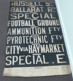
... Destinations in order from top are: DEPOT; WILLIAMSTOWN RD; RAILWAY STATION; RUSSELL ST; BALLARAT RD; SPECIAL; FOOTBALL GROUND; EXPLOSIVES FACTORY; ORDANCE FTY; AUNITION FACTORY; PYROTECHNIC FACTORY; CITY VIA HAYMARKE; SPECIAL E. ...Destinations in order from top are: DEPOT; WILLIAMSTOWN RD; RAILWAY STATION; RUSSELL ST; BALLARAT RD; SPECIAL; FOOTBALL GROUND; EXPLOSIVES FACTORY; ORDANCE FTY; AUNITION FACTORY; PYROTECHNIC FACTORY; CITY VIA HAYMARKE; SPECIAL E. ...Used by the MMTB at the Footscray Depot on X1 class tram No. 465. Destinations in order from top are: DEPOT; WILLIAMSTOWN RD; RAILWAY STATION; RUSSELL ST; BALLARAT RD; SPECIAL; FOOTBALL GROUND; EXPLOSIVES FACTORY; ORDANCE FTY; AUNITION FACTORY; PYROTECHNIC FACTORY; CITY VIA HAYMARKE; SPECIAL E. The Special E destination was used to indicate to passengers that it was a special tram to the Explosives Factory during WW2 and not tell "spys" that exactly where it was going. The Footscray system except for route 82 closed in 1962. See item 1746 for another example, though without the Special E destination.Demonstrates a Footscray Tram Depot destination roll.Destination roll - white lettering on black background, painted on bookbinder's cloth or fabric. Has unpainted sections at either end.In ink at the bottom "465"tramways, footscray depot, destination roll, trams -
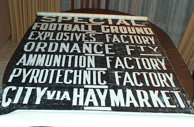 Ballarat Tramway Museum
Functional object - Destination Roll, Melbourne and Metropolitan Tramways Board (MMTB), "Footscray Depot", 1950?
... Destinations in order from top are: DEPOT; WILLIAMSTOWN RD; RAILWAY STATION; RUSSELL ST; BALLARAT RD; SPECIAL; FOOTBALL GROUND; EXPLOSIVES FACTORY; ORDANCE FTY; AUNITION FACTORY; PYROTECHNIC FACTORY; CITY VIA HAYMARKET. ...Destinations in order from top are: DEPOT; WILLIAMSTOWN RD; RAILWAY STATION; RUSSELL ST; BALLARAT RD; SPECIAL; FOOTBALL GROUND; EXPLOSIVES FACTORY; ORDANCE FTY; AUNITION FACTORY; PYROTECHNIC FACTORY; CITY VIA HAYMARKET. ...Destination roll used at the MMTB Footscray depot. Has stencil words "STOP" on top and bottom, stencilled miniature destinations on rear to assist drivers to locate the destination. Letters are 146 high. Roll consists of a unpainted section, 520 long at top, 2280 long painted section and a 1500 long unpainted section at base. Has been rolled using a 16 diameter wooden dowel - 925 long. Destinations in order from top are: DEPOT; WILLIAMSTOWN RD; RAILWAY STATION; RUSSELL ST; BALLARAT RD; SPECIAL; FOOTBALL GROUND; EXPLOSIVES FACTORY; ORDANCE FTY; AUNITION FACTORY; PYROTECHNIC FACTORY; CITY VIA HAYMARKET. This roll was not marked with the Destination of "DESTINATION E" which indicates it is post World War 2. See item 10600 for a copy with Destination E marked on. Demonstrates a Footscray Tram Depot destination roll.Destination roll - white lettering on black background, painted on bookbinder's cloth or fabric. Has unpainted sections at either end.tram, trams, mmtb, destination roll, footscray depot -
 Melbourne Tram Museum
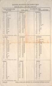
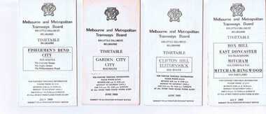
Document - Timetable - MMTB bus routes 1962 and 1963, Melbourne & Metropolitan Tramways Board (MMTB)
... Set of 7 bus timetables, duplicated sheets as noted below - printed on foolscap sheets. .1 - Sunshine Park - City - 15/3/1963 - single sheet .2 - Sunshine (via South and Dynon Roads) - City Bus - 20/7/1962 - single sheet .3 -Garden City - City - undated - single sheet .4 - Queens Bridge - Fisherman's Bend, - via various routes - June 1963, four sheets stapled in top left hand corner. .5 - Deer Park - City - 14/11/1962 .6 - Clifton Hill - Point Ormond - Esternwick - undated .7 - Ballarat Road - Footscray Station - Williamstown Rd - Russell St - 15/6/1962 - three sheets stapled in top left hand corner....Shows the method of production of timetables in the early 1960s. timetables buses MMTB Footscray Sunshine Fisherman's Bend Clifton Hill Point Ormond Garden City bus replacement Set of 7 bus timetables, duplicated sheets as noted below - printed on foolscap sheets. .1 - Sunshine Park - City - 15/3/1963 - single sheet .2 - Sunshine (via South and Dynon Roads) - City Bus - 20/7/1962 - single sheet .3 -Garden City - City - undated - single sheet .4 - Queens Bridge - Fisherman's Bend, - via various routes - June 1963, four sheets stapled in top left hand corner. .5 - Deer Park - City - 14/11/1962 .6 - Clifton Hill - Point Ormond - Esternwick - undated .7 - Ballarat Road - Footscray Station - Williamstown Rd - Russell St - 15/6/1962 - three sheets stapled in top left hand corner. ...Produced by the MMTB to provide timetable information on Melbourne bus routes to passengers. Shows the extension of the Clifton Hill to Elsternwick route to Point Ormond after the closure of tram service to Point Ormond and for services that replaced the Footscray tram lines.Shows the method of production of timetables in the early 1960s.Set of 7 bus timetables, duplicated sheets as noted below - printed on foolscap sheets. .1 - Sunshine Park - City - 15/3/1963 - single sheet .2 - Sunshine (via South and Dynon Roads) - City Bus - 20/7/1962 - single sheet .3 -Garden City - City - undated - single sheet .4 - Queens Bridge - Fisherman's Bend, - via various routes - June 1963, four sheets stapled in top left hand corner. .5 - Deer Park - City - 14/11/1962 .6 - Clifton Hill - Point Ormond - Esternwick - undated .7 - Ballarat Road - Footscray Station - Williamstown Rd - Russell St - 15/6/1962 - three sheets stapled in top left hand corner.timetables, buses, mmtb, footscray, sunshine, fisherman's bend, clifton hill, point ormond, garden city, bus replacement -
 Bendigo Military Museum
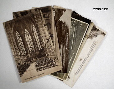
Postcard - POSTCARD - 14TH TRAINING BATTALION BAND, c1918 - 1919
... Letter signed Bob.' 11. Station Rd. Gillingham. Handwritten on back in black ink: 'Letter from R.H. ...Letter signed Bob.' 11. Station Rd. Gillingham. Handwritten on back in black ink: 'Letter from R.H. ...Postcards relate to R.H. Baron's role in the 14th Training Battalion Band. They document various places where the band played. Part of the "Robert H. Baron" No. 3596 and Cooper Collections. See Cat No. 1981P for details of Baron's service.Twelve black and white and coloured postcards featuring views of various English towns. Some cards have handwritten letters and anecdotes on the back.1. Lichfield Cathedral, Lady Chapel. Handwritten on back in black ink: 'Letter to R.H. Baron's mother dated 29.1.18.' 2. Bone Street, Lichfield. Handwritten on back in black ink: 'Anecdote, signed, Bob.' 3. The Green, East Knoyle: Handwritten on back in black ink: Letter to R.H. Baron's mother! 4. Wyndham Memorial, East Knoyle. Handwritten on back in black ink: 'R.H. Baron 14 T.B. Band. 5. Woking, Inkerman Barracks. Handwritten on back in black ink: 'Letter to R.H. Baron's sister Elsie.' 6. Chertsey Road and Red House Hotel, Woking. Handwritten on back in black ink: 'I spent a few days here while I was on leave, Bob.' 7. View at Old Woking from Bridge. Handwritten on back in black ink. 'No. 3596, L/Corp R.H. Baron, 14 T.B. Band, 57 Battalion, Aust Imp. Forces, Hurdcott, England.' 8. York Road, Woking. Handwritten on back in black ink: 'Letter to R.H. Baron's mother dated 11.1.19.' 9. Thinking of you at GILLINGHAM. Handwritten on back in black ink: 'This is the place of our last trip with the band, Bob.' 10. Glastonbury Abbey. Handwritten on back in black ink. Letter signed Bob.' 11. Station Rd. Gillingham. Handwritten on back in black ink: 'Letter from R.H. Baron to his friend, Doris. Dated August 2nd (1918?).' 12. Newbury, Gillingham. Handwritten on back in black ink. 'Partial letter written by R.H. Baron.'robert h. baron, cooper collection, postcards, 14th training battalion band, 57th battalion, ww1 -
 Whitehorse Historical Society Inc.
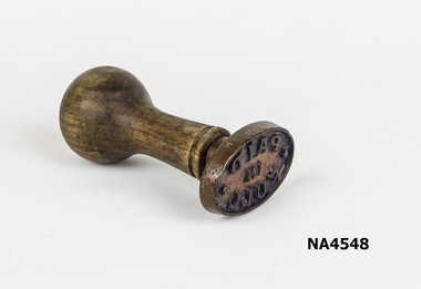
Functional object - Brass Paid Stamp, C G Roeszear & Son, circa 1920
... She told me that, for as long as she could remember - and from at least 1920 - this stamp had been used by her mother, Bertha Jane Markham (nee Cruse) when she was Post Mistress at Mitcham and that she, ( that is, my mother) had continued to use the stamp in her own shop (Cnr Station St and Whitehorse Rd) from 1944 to 1957. ...She told me that, for as long as she could remember - and from at least 1920 - this stamp had been used by her mother, Bertha Jane Markham (nee Cruse) when she was Post Mistress at Mitcham and that she, ( that is, my mother) had continued to use the stamp in her own shop (Cnr Station St and Whitehorse Rd) from 1944 to 1957. This stamp was used in Mitcham Post Office continually from 1920 to 1944 at which time the Post Office was removed from the building; it was then used in the shop at the same location until June 1957. metalcraft bronzeware Paid in full Mrs Markham's Paid Brass stamp Wooden bull shaped handle attached to a brass oval shaped stamp with words PAID IN FULL Mrs Markham was postmistress at Mitcham.It was part of her shop & dwelling cr Whitehorse Road and Station Street.Building on WCC Heritage overlay Functional object Brass Paid Stamp C G Roeszear & Son ...This stamp was made by C G Roeszear & Son Melbourne. This was passed to me by my mrother, Mary Elizabeth Millane Nee Markham. She told me that, for as long as she could remember - and from at least 1920 - this stamp had been used by her mother, Bertha Jane Markham (nee Cruse) when she was Post Mistress at Mitcham and that she, ( that is, my mother) had continued to use the stamp in her own shop (Cnr Station St and Whitehorse Rd) from 1944 to 1957. This stamp was used in Mitcham Post Office continually from 1920 to 1944 at which time the Post Office was removed from the building; it was then used in the shop at the same location until June 1957.Mrs Markham's Paid Brass stamp Wooden bull shaped handle attached to a brass oval shaped stamp with words PAID IN FULL Mrs Markham was postmistress at Mitcham.It was part of her shop & dwelling cr Whitehorse Road and Station Street.Building on WCC Heritage overlayPaid in fullmetalcraft, bronzeware -
 Melton City Libraries
Photograph, Mrs Knox and Beryl Gillespie at the First Hundred Years Celebration of Melton State School 430, 1970
... The Chaff Mill was on the corner of Station Rd and Brooklyn Rd. Mr Lumsden was manager and later years Bernie Trethowan and Jack Butler were partners. ...The Chaff Mill was on the corner of Station Rd and Brooklyn Rd. Mr Lumsden was manager and later years Bernie Trethowan and Jack Butler were partners. ...Beryl Knox speaking about early life in Melton. Page 1 1949 – 64 years ago. We began our married life at Melton Sth. The house on the corner of the Exford Rd and Staughton St-- dusty gravel roads, box thorns and noxious weeds everywhere and a sprinkling of houses and vacant land. It was a friendly community consisting of old family names. McDonalds, Blacks, Dodemaide, Cahill, Coopers, Minns, Tinklers, Nesbitts, Cochranes, Wickhams, Exells. Mavis Butler. The home owned by Mr. Robinson and Miss Robinson had been shifted in two parts transported from Diggers Rest and it is still standing 2013. Bruce’s father purchased the house and two adjoining blocks, the Conways built on one and the Rawlinson family on the other block. Eileen still resides there, she was only a baby in a pram and the family had not long arrived from England. The railway line was close to the house and the contents would rattle when heavy steams trains went through, and on a clear frosty night the 1am paper train would echo roar through very loudly when labouring towards the Exford Bridge. Then the two carriage motor train was introduced, this was great for the workers and schoolies who travelled to Melbourne. The train pulled up at the crossing or riding to pick up or drop off. Melva Gillespie (nee Hirt) Bill Cahill delivered the milk by the billy and then in bottles. Len Kennedy (Paul Kennedy’s father, Norma Murrays son) delivered Jongebloeds bread, he always had a sweep going for the Melbourne Cup and raffles for the footy club. Mr. Woodgate owned an old bus and pick up point was the Post Office when there was a Saturday film on a Melton. There were no doctors or dentists in the district. If we need a Doctor we had to travel to Bacchus Marsh or discuss problems over the phone. In later years a Bacchus Marsh Doctor rented the Bluestone building in McKenzie St a couple of days a week. If we needed the Dentist we had to travel to West Footscray or Footscray. We did our banking at “State Savings” then the Miss Minns had the agency and then Bardsleys Store. We travelled to Bacchus Marsh to the National and Commercial banks. Station Rd to Western Highway, now (High Street) was a narrow stretch of bitumen and gravel farmland either side and a couple of farm houses and large gum trees on the properties. Page 2 North of the Railway line Mrs Bessie Jones, mother of Chas and Betty Jones managed the Post Office, next door to her Chas and Betty had the Shell Centre, and later moved the business to Melton. Hughie Nesbitt and mother owned the grocery and hardware store, and I bought my first set of saucepans there. On the opposite side of Station road Mr Coombe owned the fruit shop, and also provided soft drinks and lollies for children. The Chaff Mill was on the corner of Station Rd and Brooklyn Rd. Mr Lumsden was manager and later years Bernie Trethowan and Jack Butler were partners. It finally burnt down and is a Service Station now. Along Brooklyn Rd there were a few houses and Victoria Hall, not a very big hall, but catered for lots of functions, Balls, Fancy Dress, Bazaars, Square Dancing and meetings. The Bacchus Marsh Baptists held Sunday School in the hall. A group of shops were built south of the railway line Molly and Len Skinner managed the Post Office and handled a few essential groceries. Tom McDonald and Ron Lunsberg were the butchers. Mary and Syd Cooper lived next door to us and often in turn would run out of something when we had a baking spree we would borrow or exchange, sugar flour etc over the fence. Mavis and Jack Butler lived there before the Coopers. Bernie and Iris Trethowan lived two doors up. Neighbours were invited into their home to view the first black and white television in Melton Sth. Bill Exell was one of the first Melton Sth farmers to sell his land to developers, the land was idle for years before housing developed. I joined the Melton Valley Golf Club in 1960. The Gun Club as our Club House, an old tin shed consisting a water tank, trestle table and forms and dirt floor. It was a 9 hole course with sand scraps and landscape putting before greens. The Common or parkland was part of the Golf Course. It was open for every ones recreation. Roy Norton an old identity trained his trotters on the Common and wouldn’t clear the track for the golfers. The golfers had to avoid him to continue to play. We had to keep clear when the young youths came in their paddock cars and motorbikes. Over the years the Toolern Creek flooded its banks, water and debri covered the course on one year our first Club house was flooded out. It took several working bees to clean it up. We lived at Melton Sth for 15 years and moved to Melton on the farm “Croxton Park.” The Nixon family farm “Mowbray” adjoined the farm. Bruce worked the land cropping the farm when Mrs Nixon died. Page 3 (page 4 on the handwritten script) Bruce had the first offer to buy, in those days it wasn’t easy to get good bank loans. Part of the land is the Golf Course now and Mr O’Shea purchased the bulk. Moving to Melton was totally different – I became involved with Committees, Scouts, Guides, Mothers Clubs, CWA, Church Op shop (8 years). Melton Amateurs players produced and tutored by Mabel Rogers exerts from Pyjama Game, South Pacific, Carousel - later years a group of ladies did gentle water exercise at Essendon and Station Road swimming pool. I was 20 or so years in Probus. The local followed the football, there was always a Gymkhana on the long weekend in June. The tennis always created a lot of interest during the finals. It didn’t matter which team played the supporters were treated to a cup of tea and leftovers from their afternoon tea. In 1978 were the first residents to move into the Jennings Estate Kurunjang and lived there 31 years and retired 4 years ago into Unit. The amazing changes I have experienced. Merrimu supplied our water, after depending on tanks. The landscape changed completely when developers came in, no more dusty plains \ typed web Sept 2013 McFarlane, Mrs Knox and Beryl Gillespie at the First Hundred Years Celebration of Melton State School 430. The event was held at Mechanics Hall, Melton.local identities, local significant events, education -
 Ballarat Tramway Museum
Ephemera - Timetable/s, Melbourne and Metropolitan Tramways Board (MMTB), Set of 14 MMTB Melbourne bus timetables, 1969
... Items shown with a % are larger size sheets of paper, folded into 10. 1155.1 - Clifton Hill - Elsternwick # .2 - Garden City - City # .3 - Fishermen's Bend - City .4 - Box Hill - East Doncaster via Blackburn, Mitcham via Donvale PO and Mitcham - Ringwood via Eastland .5 - Warrandyte via Templestowe, via East Doncaster, Donvale PO - City % .6 - Warrandyte, Park Orchards Ringwood .7 - Williamstown Rd., Footscray Railway Station, Ballarat Rd # .8 - Latrobe University, Northland, West Heidelberg - City # % .9 - Deer Park, Sunshine Park, Sunshine, Footscray - City # .10 - as above, but for Saturdays and Sundays on pink paper # .11 - Box Hill, Heidelberg, Templestowe .12 - Box Hill, North Blackburn .13 - East Kew, Box Hill, Doncaster .14 - Bullen, North Kew - City # % Images of a sample of documents added 16-11-2013. ...Items shown with a % are larger size sheets of paper, folded into 10. 1155.1 - Clifton Hill - Elsternwick # .2 - Garden City - City # .3 - Fishermen's Bend - City .4 - Box Hill - East Doncaster via Blackburn, Mitcham via Donvale PO and Mitcham - Ringwood via Eastland .5 - Warrandyte via Templestowe, via East Doncaster, Donvale PO - City % .6 - Warrandyte, Park Orchards Ringwood .7 - Williamstown Rd., Footscray Railway Station, Ballarat Rd # .8 - Latrobe University, Northland, West Heidelberg - City # % .9 - Deer Park, Sunshine Park, Sunshine, Footscray - City # .10 - as above, but for Saturdays and Sundays on pink paper # .11 - Box Hill, Heidelberg, Templestowe .12 - Box Hill, North Blackburn .13 - East Kew, Box Hill, Doncaster .14 - Bullen, North Kew - City # % Images of a sample of documents added 16-11-2013. ...Set of 14 MMTB timetables for various bus routes, dated July 1969. Generally includes Sat and Suns, Good Friday and Christmas day as well as weekdays, unless noted otherwise. Also includes a map of the route, detailed time points, sections, connecting services, fares, and organisation address - 616 Little Collins St. Melbourne. Have been folded into eight or ten portions. All on white paper unless noted otherwise. Items shown with an # - have a sticker modifying timetable information details on the front page. Items shown with a % are larger size sheets of paper, folded into 10. 1155.1 - Clifton Hill - Elsternwick # .2 - Garden City - City # .3 - Fishermen's Bend - City .4 - Box Hill - East Doncaster via Blackburn, Mitcham via Donvale PO and Mitcham - Ringwood via Eastland .5 - Warrandyte via Templestowe, via East Doncaster, Donvale PO - City % .6 - Warrandyte, Park Orchards Ringwood .7 - Williamstown Rd., Footscray Railway Station, Ballarat Rd # .8 - Latrobe University, Northland, West Heidelberg - City # % .9 - Deer Park, Sunshine Park, Sunshine, Footscray - City # .10 - as above, but for Saturdays and Sundays on pink paper # .11 - Box Hill, Heidelberg, Templestowe .12 - Box Hill, North Blackburn .13 - East Kew, Box Hill, Doncaster .14 - Bullen, North Kew - City # % Images of a sample of documents added 16-11-2013. mmtb, timetables, melbourne -
 Melbourne Tram Museum
Functional object - Destination Roll, Melbourne & Metropolitan Tramways Board (MMTB), "Footscray Depot", 1940's
... The roll is missing a top section, possibly (based on a Footscray roll held in the BTM Archives), DEPOT; WILLIAMSTOWN RD; RAILWAY STATION, SPECIAL E - for the Explosives Factory. ...The roll is missing a top section, possibly (based on a Footscray roll held in the BTM Archives), DEPOT; WILLIAMSTOWN RD; RAILWAY STATION, SPECIAL E - for the Explosives Factory. ...Destination roll used at the MMTB Footscray depot. Has stencil words "STOP" on bottom, stencilled miniature destinations on rear to assist drivers to locate the destination. Roll has a short unpainted section at the bottom. Destinations in order from top are: ; RUSSELL ST; BALLARAT RD; SPECIAL; FOOTBALL GROUND; AMMUNITION FACTORY; PYROTECHNIC FACTORY; CITY VIA HAYMARKET; SPECIAL E. The roll is missing a top section, possibly (based on a Footscray roll held in the BTM Archives), DEPOT; WILLIAMSTOWN RD; RAILWAY STATION, SPECIAL E - for the Explosives Factory. Through running to City from May 1954 when track extended and connected to main system. Image 3 - Photo of Bob Wilson standing alongside taken 27/7/14 by Warren Doubleday, added 28/7/14.Demonstrates a tram destination roll used at Footscray Depotl. Destination roll - white lettering on black background. trams, tramways, mmtb, destination roll, footscray depot -
 Eltham District Historical Society Inc
Photograph, George Burton Coop, The Royal Train enroute to Lilydale, near Croydon, 6 Mar. 1954
... It was suggested that the train slow down between the railway station and Dorset Rd. bridge at Croydon, and between the Cave Hill Quarry and railway station at Lilydale.” ...It was suggested that the train slow down between the railway station and Dorset Rd. bridge at Croydon, and between the Cave Hill Quarry and railway station at Lilydale.” ...Believed to have been taken bewteen Croydon Railway Station and the Dorset Road bridge. Taken late afternnon by George Coop's father. There is a Landrover parked on the grass with a person standing on it - believed to be Security. George recalls originally being located closer to the fence and being ushered up the hill where it was 'safer' to stand. In 1954 at age 27, Queen Elizabeth II was the first reigning British monarch to visit Australia.. She visited Victoria between March 1-10. Where to see the Queen (1954, January 21). Fern Tree Gully and District Times (Boronia, Vic. : 1953-1954), p. 5. Retrieved October 25, 2021, from http://nla.gov.au/nla.news-article264220429 “The Lilydale Shire President, Cr. Burgi, stated that the Royal train en route for Warburton on Saturday, March 6th, would slow down at Croydon and Lilydale. There was little possibility that it would stop at either of these towns. The train would pass through Lilydale at 5.52 p.m. Council had appointed a sub-committee to arrange matters, and had allocated £400 towards expenses. It was suggested that the train slow down between the railway station and Dorset Rd. bridge at Croydon, and between the Cave Hill Quarry and railway station at Lilydale.” An album of images of the Queen's visit to Victoria is available on the PROV Flickr account at https://www.flickr.com/photos/public-record-office-victoria/7252885616Digital TIFF file Scan of Kopdak 620 black and white negative transparencygeorge coop collection, croydon, royal train -
 Melton City Libraries
Map, Streets of Melton, 1963
... Three members of family - Shire Presidents HURLEY Street Farmers IAIN Court Descendent of James and Mary McPherson JAMES MELROSE Drive Name appears on 2013 Melton information map JANG Place KURUN – jang KIRKTON Drive Name of the McPherson family home Toolern Vale Road KIRWIN Street Michael early landowners (deleted for freeway construction) KILPATRICKS Road Deleted when Barries Road was extended across Station Rd KOROROIT Court Early map, Parish of Kororoit. ...Three members of family - Shire Presidents HURLEY Street Farmers IAIN Court Descendent of James and Mary McPherson JAMES MELROSE Drive Name appears on 2013 Melton information map JANG Place KURUN – jang KIRKTON Drive Name of the McPherson family home Toolern Vale Road KIRWIN Street Michael early landowners (deleted for freeway construction) KILPATRICKS Road Deleted when Barries Road was extended across Station Rd KOROROIT Court Early map, Parish of Kororoit. ...MELTON’S STREETS Heritage Week 2014 What’s in a Name? Alphabetical List Aboriginal place names, Early Family Names and landowners, Agricultural, Shop and Commercial premises, Places and Events Melton & District Historical Society Street Naming Project 1972 – c 1998 Suburb Name – KURUNJANG - Kirkton, 1972, Brookfield, West, 1988 Melton and Town Centre - A joint collaboration with the Shire of Melton and Subdivision Developers ARNOLD Court – Family house - Arnolds Creek ALKEMADE Drive Family – Lime kilns Coimadia ALEXANDRA Street 1902 – Corination of King Edward VII and Queen Alexandra AVIATOR Place Event, location of plane crash – Jimmy Melrose 1936 Adina ?Annibee - Anniba? Agricultural Avon court .. .. BAKERY Square - Location of Jongebloed shop, bakehouse and stables BALUK Place Aboriginal BARLEYCORN Place Agricultural BILLING Place Name of Jimmy Melrose Uncle Noel Pemberton Billing BLACKWOOD Drive - Alexander Blackwood 1860c Registrar BARRIES Road C. E. Barrie “Darlingsford” farmer 1911, chaff mill owner BROOKLYN Road Staughton family residence. 1875 – Dismantled c 193? CAHILL Drive Family - Glenville Dairy CAMERON Court Family Canopus Place ? CANALLAN Drive Early Surveyor CAMPBELL Court Aviation – Melrose passenger 6th July 1936 CARBERRY Drive Michael, early landowner family CAREW Court Edward and Michael. Royal Hotel. Vera (Carew) Forran Singer - Opera CASEY Court Family CASHIN Court Family CHEVIOT Court Agriculture, breed of sheep CHESNEY Road was re named ( Minns Road being duplicated c 1973) CHRISTINA Crescent Christina McPherson, daughter of James and Mary Mary McPherson. Died 1955 aged 85 years COLLYER Close a deleted street (parallel to Yuille) re-used CORRIEDALE Road Breed of sheep CORR Court Teacher at first school, landowner CROXTON Court Name of the Hornbuckle and Knox family home DALEY Court - William Daley and family 1865 Bootmaker High Street DARLINGSFORD Boulevard - Name of early homestead Thomas B Darling 1853 DJERRIWARRH Court - Parish County of Bourke - very early map. DODEMAIDE Place Early land owners - Melton Football Team had 6 brothers playing c 1924 DONALD Court McPherson family 6 generations in Melton in 1936 DOUGAL Court DUNCAN Court .. .. DUNVEGAN Circuit Home of the McPherson family, castle Isle of Skye Name of bluestone house Smith Street (now at Willows) EMIL Court Jongebloed family EXELL Avenue Farming family Melton Sth- Closer Settlement 1907 EXFORD Road Exe former name of the Werribee river FARMER Court Name of early postmistress FERRIS Road John Ferris Farmer HANNAH Close First name of Hannah Watts – midwife HAYBALE Place Agricultural HELDER Court Early surveyor J Helder Wedge map HEWSON Street Winston Hewson Shire Engineer – check title c 1960 HENRY Street Township map c 1860 HESTON Street Heston Phoenix – C.J. Melrose plane HILDEGARDE Court Jimmy Melrose’s mothers name HOMESTEAD Close HORNBUCKLE Cres Farmers. Three members of family - Shire Presidents HURLEY Street Farmers IAIN Court Descendent of James and Mary McPherson JAMES MELROSE Drive Name appears on 2013 Melton information map JANG Place KURUN – jang KIRKTON Drive Name of the McPherson family home Toolern Vale Road KIRWIN Street Michael early landowners (deleted for freeway construction) KILPATRICKS Road Deleted when Barries Road was extended across Station Rd KOROROIT Court Early map, Parish of Kororoit. Creek name KNOX Circuit Family – Hornbuckle “Croxton Park” KURRUNJANG Drive Aboriginal name for people of the red earth – Suburb name Lara Place ? LLOYD Court Garage owners High Street. Laura lived to 100 years D 1955 LUBY Court John Luby – Crown Grant Land Title LITTLE Court MANNING Avenue Richard, hotel owner 1891 MARGARET Drive McPherson family McDONALD Street Melton South family name McKENZIE Street Township c1860 MORROW Street Early name MOWBRAY Crescent Name of English Melton, popularly believed origin of Melton MYERS Court Early setters c 1866 Crown Grant Land Title NIMMO Street Early name NIXON Street Name submitted by Mary nee Nixon Collins c1985 OLDERSHAW Road Early builder PALMERSTON Street Early township map c 1860 PEART Court Early name PENNYROYAL Avenue Plant growing by the creek. Early name used for the Toolern Toolam Creek PINKERTON Street Family name and early street map PINNACLE Crescent Agricultural - type of wheat PHOENIX Circuit C.J. Melrose Phoenix Heston Plane 2013 map PRATT Family PRIOR Court PYKE Place Brothers – early settlement 1838 RADFORD Court Land owners and business operators. Former Royal Hotel Grocer High Street demolished 1970 RAGLAN Court Hotel 19th century Lord Raglan RALEIGHS Road Oliver Reierson family (Norweigen) Shopkeeper – Dressmakers RIDDELL Drive (misspelt Riddle) Resident and land owner RODERICK Road McPherson family – a re occurring name ROLLAND Court Jones family ROSS Court Daniel. Landowner. Agnes Ross music teacher RUSSELL Court Robert. Early land surveyor of Melton 1853 RYAN Court Family early landowner. Member of the 1862 Road Board SHEBLER Place Augustus early Melton resident – Golden Fleece Hotel SHEEPFOLD Court Farming SHERWIN Court Sherwin Street earliest Township map– became Golf course SMITH Street Early township map. STRATHULLOH Circuit Strathtulloh Homestead. STAUGHTON Street Family – LARGE land owners Strachan ? SWANEY Court Marie Swaney earlier resident of Strathtulloh. SUTHERLAND Family name TOOLERN Street TOOLAM – TOOLERN Creek TULLIDGE St Road marked on 1861 map UNITT Street Early Township c 1860 WALLACE Square Cr Jack Wallace 5 terms as President 46 years unopposed WATTS Court Hannah Watts – midwife, cottage hospital WALSINGHAM Name of house of Minns family. From Walsingham Norfolk England WESTLEY Place Name of Jimmy Melrose Percival Gull Plane WESTLAKE Drive Early resident WHICKHAM Street Family Name Melton South WILSON Road Albert, Melton South YUILLE Street William Cross, early landowner, Rockbank run Zoomed in section of Melton Streets including Church and High Streetlandscapes of significance -
 Melton City Libraries
Book, Frederick Myers work notebooks/diaries, 1923-1933
... Expenses include 12 + 6 Cutters, 2+2+2 Combs, Political fund, Ticket, Mess Account, Hut Keeper, Hospital, Cook Total L11..8..3. Station Rd - L11..2..9. Golf Hill Sept 26 Cut out 31 Oct Total 2332 Lal Lal Nov 6th 19th 1912 6 days Total 1066 Contracts – Cameron, Barrie, McKay, Toohey, Stn Rd ? ...Expenses include 12 + 6 Cutters, 2+2+2 Combs, Political fund, Ticket, Mess Account, Hut Keeper, Hospital, Cook Total L11..8..3. Station Rd - L11..2..9. Golf Hill Sept 26 Cut out 31 Oct Total 2332 Lal Lal Nov 6th 19th 1912 6 days Total 1066 Contracts – Cameron, Barrie, McKay, Toohey, Stn Rd ? ...FREDERICK THOMAS MYERS Born 20th February 1877 at Melton Married Martha Mary Watson 30th April 1908 at the Manse 101 Gore Street Fitzroy according to the rites of the church (Cong) – Congregational. Died Bacchus Marsh and District War Memorial Hospital 30th April 1963 Frederick lived in Melton all his life. Work Notebooks/ diary 1901 – 1905 No 1 1901 Shearing Tally Rockbank, 1901, 1902. Lists 3 Combs 6.0, 12 Cutters 5.0, Tab 1.6 Jongebloed account – Tobacco, matches sardines. Shearing shed 1904 Tuppal 20 Aug. Daily Tally of sheep shorn Total 1730 E C Shopping list - 6 pages of household items, Leader, Age and Weekly Times Tomato Sauce- recipe written in ink Toolern Road Hours worked 35 ½ Reverse order from back cover – Harwood 29th Aug 1902 Shearing Tally 1083 November 1902 - List of dates Mon- Sat. Nov 3rd - Fri Dec 5th E Chalmer. Tally of hours worked. Jan 1903 Thur 1st - 31st Toohey Keilor Road, Feb – March 14th Payment L75:4:9 J Walker April 1903 – 23rd 18 Cutters 7:6 5 Combs 10:0 2 Tab 3:0 Ticket 15:0 Total 1:15:6 Tucker 3:12:6 Other pages are calculations related to hours worked and amounts The notebook contains 26 pages with some blank and other torn out. It measures 2 ½ x 4 inches with a hard black cover. FREDERICK MYERS Workbook/ Diary No 2 Opening 5 pages – Gottfried Jongebloed account - paid 2/11/04 List of grocery and household items. E Chalmer -Pr Boots, 8:9 Tab 1:8 Leader 3’ Reverse order Eynesbury 7th Oct 1904 Shearing Tally 1635 Tucker payment L1:18:6 Tuppal 20th Aug 1904 Tally 1636 [ 4 weeks and 4 days] Feb 1905 Melton 1st – 13, Toolern Rd 14th , April Braybrook Rd. Melton town, G Hobbs Boundary Rd, Melton May G Hobbs 2 pages of food expenses and amount paid Simpson & Co – Butcher account and amount paid Mon 5th –July 22nd Toohey days and hour worked 34 yards Tuppal 20th Aug additional list 1735 Eynesbury 3rd Oct additional list 2093 Diagram 3 drawings in ink –a type of tool Nov 21 1904 List Dunmore Stn Orford Vic Barwidgee Stn Caramut Vic Wharparanna Stn via Tocumural N.S.W. Puckawidgee vis Aug Deniliquin N.S.W. Bundure Stn via Aug Jerilderie Trawalla Ballarat Oct Woorywooryte Oct Vic Yancannia Bourke July Pretty Tower Stn Beaufort November Size of Notebook 2 ¼ x 5 inches. WORK NOTEBOOK 1909, 1910 Wandook 17th Aug 1909. 21 days of shearing 1248 Total. Payment L14 ?? Boomanoomana 23 Sept 1909. 17 days shearing 1124 Total. L13.12.9 Eynesbury 20th Oct 1909. 17 days shearing 1587 Total L17. 13.0 Cobran Aug 13 1910 Studs Rams Total 3397 List of expenses includes 12 cutters, 3 combs, Union ticket, matches, tobacco stamps. Miller, J Egan. Eynesbury Oct 1910 Total 1467 Lal Lal Nov 21 Total 1172 For Backache Tincture of Gentian Compound one ounce Syrup of Rhubarb one ounce Liquid Barkola Compound one ounce Syrup of Ginger five ounce Dose a teaspoonful after each meal and one at bedtime John Collins, Woodside Via Yarram Yarram Mr Fisken Lal Lal Via Yendon Woodlawn Deniliquin 15th October Oct 12th 1911 Eucla Jarrett Barfold 21,000 7? Shearers Clark Moir Estate 10th Aug 1910-1911 Income amounts Shearing income. Mc Donald – thrasher Keating Toohey Cobran 1911 Studs and Rams 1793 Cobran 14th Aug per man 1500 Golf Hill 26th Sept per man 1900 Cobran 14th Aug Cut out 23rd Sept 2368 payment L21..19..4 [after expenses] Spring Plains Oct 2nd 1022 Total Barfold 2636 Total Chaffcutting J.B. Loft Feb 17th - 31 ½ hours John Minns Toohey Started Deep Creek Whelahan Ballarat Rd May 25th Mr J Walker Koohnamu Stn via Junta S.A. N Aitken Bringlibit via Kyneton Income list 1911 to 1912 and amounts earned Cobran L29..0..9 , Spring Plains Barfold L42..6..3, John Minns L4..8..0, J.B. Loft L3..0..6, D Whelahan L22.. 6..0, E Toohey L15.. 1..0, = total L123..2..6 John Minns 12..0, JB Loft 4.. D Whelahan L10..2..0, Barrie L11..5. Total Amount L145..5..6. Cobran 1912 15th Aug 1922 total Rams double. Expenses include 12 + 6 Cutters, 2+2+2 Combs, Political fund, Ticket, Mess Account, Hut Keeper, Hospital, Cook Total L11..8..3. Station Rd - L11..2..9. Golf Hill Sept 26 Cut out 31 Oct Total 2332 Lal Lal Nov 6th 19th 1912 6 days Total 1066 Contracts – Cameron, Barrie, McKay, Toohey, Stn Rd ? Cobran 1913 – Aug 14- 1913 Total 1621 Cobran 1621 Kyneton Park 515 Golf Hill 2144 Lal Lal 1066 Total 5,346 1913 – 1914 Income 5, 350 sheep Local contracts E. Barrie, Greig, Weir, S Barrie, Jongebloed, Burton, E Toohey, Total L133..3..0. Trench & Moran L19..8..0. End of front section of Notebook Work notebooks belonging to Frederick Myers local identities -
 Bendigo Military Museum
Letter - LETTER AND ENVELOPE, Edna Johnson, 10 April 1942
... .1) Address on top - Edgemont Station, Box 241, East St, Louis, Ill, USA, April 10th 1942. .2) Signed "Sincerely Edna Johnson. .1) Address on front, Mrs Enid Granger, 32 Mt Korong Rd, Bendigo, Victoria, Australia....US Soldiers Censorship Letter .1) Address on top - Edgemont Station, Box 241, East St, Louis, Ill, USA, April 10th 1942. .2) Signed "Sincerely Edna Johnson. .1) Address on front, Mrs Enid Granger, 32 Mt Korong Rd, Bendigo, Victoria, Australia. .1) & .2) A4 page typed letter (2 pages) from Edna Johnson to Enid Granger. ...Letter was from a USA family member of a US soldier staying at a private residence in Bendigo. The US soldier was not permitted to communicate with family members as to their location. the Granger family circumvented that by sending a cable to his family and this letter was a reply to them..1) & .2) A4 page typed letter (2 pages) from Edna Johnson to Enid Granger. Black typed writing on cream coloured paper. Address on top and signed off on page 2. .3) Cream coloured envelope, address on front and six stamps. Various black stamps on front and air mail stamp address from written on back. .4) Small newspaper cut out photo of a young girl..1) Address on top - Edgemont Station, Box 241, East St, Louis, Ill, USA, April 10th 1942. .2) Signed "Sincerely Edna Johnson. .1) Address on front, Mrs Enid Granger, 32 Mt Korong Rd, Bendigo, Victoria, Australia.us soldiers, censorship, letter