Showing 12 items matching "stone marker"
-
 Ballarat Heritage Services
Photograph - Digital photographs, L.J. Gervasoni, Marker at Koroit Railway Station, 2016
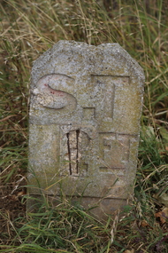
... ...stone marker...Ballarat Heritage Services PO Box 2209 Bakery Hill Post Office goldfields transport rail trail koroit koroit railway station stone marker stone marker roadside verge Digital image of a Marker at Koroit Railway Station Marker at Koroit Railway Station Photograph Digital photographs L.J. ...Digital image of a Marker at Koroit Railway Stationtransport, rail trail, koroit, koroit railway station, stone marker, stone, marker, roadside, verge -
 Ballarat Heritage Services
Photograph, LJ Gervasoni, Scarsdale/Linton Milepost (or Milestone), 20-06/2009
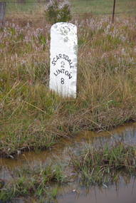
... ...mile marker...stone...Stone and iron mileposts are now a rarity, and have remanining markers have become a tourist attaction in many smaller towns with remnant markers. ...Stone and iron mileposts are now a rarity, and have remanining markers have become a tourist attaction in many smaller towns with remnant markers. ...Stone mileposts dating from the 1870s are found on the Glenelg Highway. Stone and iron mileposts are now a rarity, and have remanining markers have become a tourist attaction in many smaller towns with remnant markers. The stone mileposts on the Glenelg Highway are listed on the Victorian Heritage Reigister as being significant to the State of Victoria. Their primary purpose is to inform the travelling public of distances and directions to various destinations. The stone milepost in the current City of Ballarat are located on the Glenelg Highway (between Ballarat and Scarsdale), Smythes Creek and Delacombe, and have been registered by Heritage Victoria, (HO155) Other stone mileposts are located In Golden Plains Shire at Smythesdale (Victorian Heritage Register H1701) Metrication in Australia caused former mile markers to be gradually replaced with 10 km markers on highways and country roads, which are referred to as "kilometre plates".Colour photograph of a stone mile post on between Ballarat, Scarsdale and Lintonmilepost, mile post, scarsdale, linton, ballarat, mile marker, stone milepost, milestone -
 Bendigo Historical Society Inc.
Book - Out & About in Bendigo
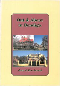
... Historical markers plaques stones tabulets and photos from an area covering Huntly across to Junortoun to Strathfieldsaye , Mandurang , Big Hill, Maiden Gully and around Eaglehawk...History House 11 Mackenzie Street Bendigo goldfields Historical markers plaques stones tabulets and photos from an area covering Huntly across to Junortoun to Strathfieldsaye , Mandurang , Big Hill, Maiden Gully and around Eaglehawk Black and White photos Maps Out & About in Bendigo - Jean & Ken Arnold Cream outer edge with plum coloured insert with black writing. ...Historical markers plaques stones tabulets and photos from an area covering Huntly across to Junortoun to Strathfieldsaye , Mandurang , Big Hill, Maiden Gully and around EaglehawkOut & About in Bendigo - Jean & Ken Arnold Cream outer edge with plum coloured insert with black writing. Front cover Photo Langley Hall Botanical gardens and former Orphanage building Back cover various photos. Pages 80. black and white photos, maps -
 Bendigo Historical Society Inc.
Document - MYSTERY OF JOHN MCMAHON'S GRAVE BIG HILL
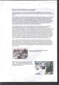
... The Mystery of John McMahon's Grave, Big Hill mentions granite stone markers south of the Tunnel. Some believed he was buried there, but further research has found he is buried at the Kangaroo Flat Cemetery in the Roman Catholic section, Grave No. 1134 on 20 May, 1874. ...History House 11 Mackenzie Street Bendigo goldfields PERSON Individual john mcmahon Mystery of John McMahon's Grave Big Hill John McMahon Big Hill Tunnel Mrs I Marchesi Mr Marchesi Mrs Ivy Irene Marchesi (nee Bone) Sarah McMahon Sarah McEwan (McKeown/McKeon) Ravenswood Station Kangaroo Flat Cemetery Sarah Jane McMahon Frederick Benton PictureAustralia Vic Rail Melbourne to Mount Alexander-Murray Rail Line Stone markers for John McMahon The Mystery of John McMahon's Grave, Big Hill mentions granite stone markers south of the Tunnel. ...The Mystery of John McMahon's Grave, Big Hill mentions granite stone markers south of the Tunnel. Some believed he was buried there, but further research has found he is buried at the Kangaroo Flat Cemetery in the Roman Catholic section, Grave No. 1134 on 20 May, 1874. Also mentioned is his widow was appointed Gate Keeper at Ravenswood on 2 September, 1874. Also mentioned is the death of Frederick Benton, who died on 24 February, 1860 of peritonitis. There is a sepia? Photo taken of the Big Hill Tunnel (Bendigo side looking south) from Picture Australia c. 1875 and a coloured one of the Big Hill Tunnel Bendigo side (photo taken March, 2008). On page 2 are two coloured views at Big Hill for John McMahon, 850 metres south of Big Hill Tunnel entrance, Melbourne side/east of line (photos taken March, 2008).person, individual, john mcmahon, mystery of john mcmahon's grave, big hill, john mcmahon, big hill tunnel, mrs i marchesi, mr marchesi, mrs ivy irene marchesi (nee bone), sarah mcmahon, sarah mcewan (mckeown/mckeon), ravenswood station, kangaroo flat cemetery, sarah jane mcmahon, frederick benton, pictureaustralia, vic rail, melbourne to mount alexander-murray rail line, stone markers for john mcmahon -
 Orbost & District Historical Society
black and white photograph, April 20 1970
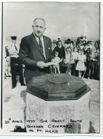
... He is standing in front of an octagonal-shaped directional marker set ointo a stone support. There is a policeman behind him. ...He is standing in front of an octagonal-shaped directional marker set ointo a stone support. There is a policeman behind him. ...Sir Henry Bolte, premier of Victoria, renamed Cape Everard at Point Hicks during the Centenary of Cook's Landings on April 20, 1970. There is no land feature at Cook's coordinates of 38°0'S and 148°53'E, a point which lies several miles out to sea and under 50 fathoms of water. Captain Cook invented Point Hicks so that he could conceal Bass Strait and the insularity of Tasmania. The Admiralty had issued its usual instructions to hide strategically important discoveries that could become security risks. Captain Hicks was James Cook`s senior lieutenant. There has been some dispute as to whether Zachary Hicks actually saw Point Hicks or whether he saw Ram Head about 20 kilometres further up the coast. Although Cook named the promontory Point Hicks it was changed to Cape Everard in 1843.. In 1970 the Victorian government changed the name Cape Everard to 'Point Hicks'. It lies on dry land, about 22 nautical miles (41 km) northeast of Cook's phantom Point Hicks, where it preserves the story of Cook's first landfall in Australia. This is a contemporary pictorial record of a significant event in East Gippsland's history.A black / white photograph of a man in a suit making a speech with the audience standing behind him. He is standing in front of an octagonal-shaped directional marker set ointo a stone support. There is a policeman behind him. In the background to the right is a lighthouse.on front - "20th April 1970, Sir Henry Bolte renames C. Everard as Pt Hicks" handwritten in block letterscook-james-point-hicks cape-everard bolte-henry -
 Flagstaff Hill Maritime Museum and Village
Financial record - Record Book, Warrnambool Lighthouse Book, ca. 1870s
... In 1871 the Complex was transferred stone-by-stone to Flagstaff Hill, where the flagstaff had been installed since 1853. The Lower Light was erected on top of a bluestone obelisk that was built in 1854 as a navigational marker. ...In 1871 the Complex was transferred stone-by-stone to Flagstaff Hill, where the flagstaff had been installed since 1853. The Lower Light was erected on top of a bluestone obelisk that was built in 1854 as a navigational marker. ...Referencing works and removal of fittings and furnishings. Further on the book appears to have been used as a note book on further pages. WARRNAMBOOL'S LADY BAY LIGHTHOUSE COMPLEX; – The original Lady Bay Lighthouse Complex was built on Middle Island in 1858-1859 and comprised the Upper Light, Store (Chartroom), Cottage and Privy. The Lower Light was on a wooden tower on the beach of Lady Bay. In 1871 the Complex was transferred stone-by-stone to Flagstaff Hill, where the flagstaff had been installed since 1853. The Lower Light was erected on top of a bluestone obelisk that was built in 1854 as a navigational marker. The bluestone Lighthouse Keeper’s Quarters was a cottage divided into two compartments, one for the Senior Keeper and his family, the other for the Assistant Keeper and his family. The bluestone Store was divided into three; a store, a workshop, and an oil store (or office). The Privy was a small building divided into two separate, back-to-back toilet rooms, one for the Senior Keeper and his family and one for the Assistant Keeper and family. The record book from the Warrnambool Lighthouse is significant because of its connection with the Lady Bay Lighthouse Complex. The Lady Bay Lighthouse Complex is significant for its important role in the safe navigation of sailing and steam ships into and out of Lady Bay and the Port of Warrnambool. during the colonisation of Victoria and the settlement of southwest Victoria. The lighthouse also helped the passing ships to check the accuracy of their navigation along the southwest coast of Victoria and facilitated the call for help when vessels were in trouble.Warrnambool Lighthouse Book. Green hard covered book with red spine and reinforced corners. Inside are pages with printed horizontal linesBook detailing the cost of removal of the Lighthouse Station from Middle Island to its present location. Also other details. flagstaff hill, warrnambool, shipwrecked-coast, flagstaff-hill, flagstaff-hill-maritime-museum, maritime-museum, shipwreck-coast, flagstaff-hill-maritime-village, warrnambool lighthouse book, record of lighthouse relocation warrnambool, warrnambool historic record book, financial record, middle island -
 Bendigo Historical Society Inc.
Newspaper - Newspaper articles by Ken Arnold, Out &About, 2000 - 2003
... Stone. Pyramid Hill 1.9.00 13. Cairn. Carisbrook 8.9.00 14. Commemorative Markers. ...Stone. Pyramid Hill 1.9.00 13. Cairn. Carisbrook 8.9.00 14. Commemorative Markers. ...Ken Arnold is a Bendigo author and publisher.A series of one hundred and thirty-five articles written by Ken Arnold and published in the Bendigo Weekly between 2000 and 2003. Each article has a topic or theme and includes historical information and details. Each article includes a photograph. The articles are stored in a red vinyl covered two ring A5 folder. Index below. Number Article Name Date 1. Centenary of Victoria 19.5.00 2. Storm Water Drain 26.5.00 3. Granite Rollers 2.6.00 4. Poverty Mine 9.6.00 5. Golden Monument. St Arnaud 16.6.00 6. Turner Statue 7.7.00 7. Gold Monument. High St Golden Square 30.6.00 8. Gold Monument. Howard Square Bendigo 14.7.00 9. Lansell Statue 21.7.00 10. Shelbourne West School 18.8.00 11. Mologa’s State Schools 25.8.00 12. Salinity Stone. Pyramid Hill 1.9.00 13. Cairn. Carisbrook 8.9.00 14. Commemorative Markers. Taradale 15.9.00 15. Burke Monument. Castlemaine 22.9.00 16. Cairn. Harcourt area 29.9.00 17. Cairn Marks Gold Route 6.10.00 18. Volcanic Rock Cairn. Woodstock 13.10.00 19. Garfield Water Wheel 20.10.00 20. Anticline. Castlemaine 27.10.00 21. Lawson Bridge 10.11.00 22. Plaque. Sutton Grange area 17.11.00 23. Memorial Cairn. Maryborough 1.12.00 24. Lonely Grave 8.12.00 25. Moonlight Flat Church 5.1.01 26. Historic Church. Near Tullaroop reservoir 12.1.01 27. Granite Statue. Castlemaine 19.1.01 28. Marker. Near Tullaroop reservoir 25.1.01 29. Church Site. Mologa 2.2.01 30. Church Site. Mologa 9.2.01 31. Plaque. Mologa 16.2.01 32. Mincha School 23.2.01 33. Historic Marker. Mincha 2.3.01 34. Expedition Marker. Pyramid Hill 9.3.01 35. Irrigation Marker. Tragowel 16.3.01 36. Mologa School Sites 23.3.01 37. Cairn. Pyramid Hill 30.3.01 38. Plaque. Pyramid Hill 6.4.01 39. Bristol Hill Lookout Tower. Maryborough 12.4.01 40. Eppalock Reservoir 20.4.01 41. Colbinabbin Cairn 27.4.01 42. Mount Macedon Cross 4.5.01 43. Memorial Gateway. Macedon 11.5.01 44. Cairn. Daylesford 18.5.01 45. Grave. Carlsruhe 25.5.01 46. Water Tower. Elmore 1.6.01 47. State School Site. Glenalbyn 8.6.01 48. Cairn. Kanya 15.6.01 49. Lonely Grave. Wedderburn 22.6.01 50. Church Cairn. Glenalbyn 29.6.01 51. Kamarooka School 6.7.01 52. Granite Marker. Moyston 13.7.01 53. Memorial Park. Kerang 20.7.01 54. Water Plaque. Bears Lagoon 27.7.01 55. Cemetery. Bears Lagoon 3.8.01 56. Race Monument 10.8.01 57. Cairn. Pyalong 17.8.01 58. Cairn. In memory of Edward Parker 24.8.01 59. Mt Macedon 31.8.01 60. Mt Macedon Cairn 7.9.01 61. Expedition Pass. Chewton 14.9.01 62. Granite Archway. St Arnaud 21.9.01 63. Stuart Mill School Site 28.9.01 64. School Site. Beazley’s Bridge 5.10.01 65. Fosterville 12.10.01 66. Barnadown 19.10.01 67. Salisbury School Site 26.10.01 68. Cricket History at Wattle Flat 2.11.01 69. School Site. Waterloo Plains 9.11.01 70. Carapooee School Site 11.01 71. Turkish Gun. Maldon 11.01 72. Kooreh 30.11.01 73. Marnoo East School 7.12.01 74. Bulgana Site 14.12.01 75. Emu School 21.12.01 76. Kooroocheang 4.1.02 77. Church Site. Gre Gre North 11.1.02 78. Carmens Tunnel. Maldon 18.1.02 79. Monument. Maldon 25.1.02 80. Woodfull Plaques. Maldon 1.2.02 81. Carapooee. St Peters Anglican Church 8.2.02 82. Cairn. Kingower 15.2.02 83. Cob & Co Stopover. Rheola 22.2.02 84. Flynn Monument 1.3.02 85. The Welcome Stranger. Moliagul 8.3.02 86. Campbell’s Creek Reserve 15.3.02 87. Mine. Fryerstown 22.3.02 88. Escott Grave. Near Chewton 28.3.02 89. School No 808. Kurting area 5.4.02 90. Graves. Bendigo Creek 10.5.02 91. School. Fish Point, Benjeroop North 17.5.02 92. Old Township. Diggora 24.5.02 93. Diggora West (1) 31.5.02 94. Diggora West (2) 7.6.02 95. School No 2735. Gower East 14.6.02 96. Pannoomilloo 21.6.02 97. Kamarooka Settlement 28.6.02 98. Mincha West State School No 1931 5.7.02 99. Bridges. Arnold 12.7.02 100. Woodvale 19.7.02 101. A Famous Son of Raywood. Jack Donaldson 26.7.02 102. Tandarra Area Schools 2.8.02 103. Dingee 9.8.02 104. Avonmore 30.8.02 105. Myola East School 6.9.02 106. Colbinabbin West 13.9.02 107. Colbinabbin West School 20.9.02 108. Runnymede area 27.9.02 109. Wanalta 4.10.02 110. School Sites. Between Wanalta and Carop 11.10.02 111. Burramboot 18.10.02 112. Kangaroo Chair. 25.10.02 113. Mincha South 1.11.02 114. Woodlands Church 8.11.02 115. School site. Sylvaterre 15.11.02 116. Terrick Terrick 22.11.02 117. Leitchville 29.11.02 118. Pennyweight Cemetery. Castlemaine 6.12.02 119. Mincha Area 13.12.02 120. Musk School 20.12.02 121. Dowie Park. Carisbrook 3.1.03 122. Neereman School Site 10.1.03 123. Bald Rock 17.1.03 124. Sylvaterre School Site 24.1.02 125. Carlsruhe 31.1.02 126. Athenaeum. Maldon 7.2.03 127. School. Mincha West 14.2.03 128. Yarraberb 21.2.03 129. Settlement Marker. Ravenswood Estate 28.2.03 130. Comini Reserve. Ravenswood 7.3.03 131. Ironbark and Gold Track. Whroo 14.3.03 132. Burke and Wills Obelisk. Castlemaine 21.3.03 133. James Cook Statue. Myers St Bendigo 28.3.03 134. St Marys Church. Axedale 4 .4.03 135. Butter Factory Site. Warragamba 11.4.03 events, monuments, historical sites, landmarks -
 Returned Nurses RSL Sub-branch
Photograph - 5.5x4 coloured photograph, 1996
... marker and the point of the pyramid will align with the site of the sinking. [Taken from ANZAC Square record] AHS Centaur Memorial Centaur War memorials Tweed Heads Queensland war memorials 'Centaur / Memorial. / Danger Pond / Tweed Heads' [Handwritten in blue ink on the back of the photograph] 'SEP 96 05633 M8NAA' [Printed on the back of the photograph] Coloured photograph of a stone memorial set in a pond with a concrete edge and surrounded by small stones. ...Centaur Memorial in Tweed Heads In Queensland. 'Memorial information: Description- A steel pyramid supported by a 15 tonne pink granite stone from Turallin near Millmerran on the Darling Downs. The bolder symbolises the ecology, the pyramid represents the spirit of those who died in the Centaur sinking and the whole effect is of flotation. The tip of the pyramid can be removed to expose an oil fuelled lamp which burns on the night of the anniversary of the sinking. Scrolls containing the names of those on board are also contained in the pyramid. A Walk of Remembrance leads from the memorial to the cliff top. The Centaur Memorial along with theUnited States Destroyer, USS Mugford Memorial were unveiled on 14 May 1993, the 50th anniversary of the sinking of the Australian Hospital Ship. The Walk of Remembrance is dedicated to the memorial of the men and women who lost their lives in the forty-one Allied and Australian Naval and Merchant ships sunk along Australia's coastline during World War Two. It is planned to place a marker in the ground adjacent to the pyramid; this marker and the point of the pyramid will align with the site of the sinking. [Taken from ANZAC Square record] Coloured photograph of a stone memorial set in a pond with a concrete edge and surrounded by small stones. The pond is on flat grassy land and behind it are stone steps for seating. In the background are trees and a pavillion.'Centaur / Memorial. / Danger Pond / Tweed Heads' [Handwritten in blue ink on the back of the photograph] 'SEP 96 05633 M8NAA' [Printed on the back of the photograph]ahs centaur memorial, centaur, war memorials, tweed heads, queensland war memorials -
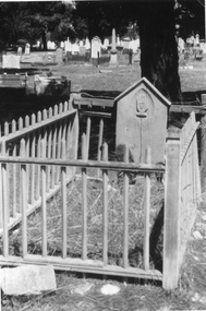 Stawell Historical Society Inc
Photograph, Wooden Grave Marker at the Stawell Cemetery
... The timber headstone has a hand carved into the head stone with a heart in the middle. Wooden Grave Marker at the Stawell Cemetery Photograph ...This photograph is the grave of William Jago, 12 August 1864, aged 26 yearsBlack & White photograph of a grave with a timber headstone. The grave has a fence enclosing the grave. The timber headstone has a hand carved into the head stone with a heart in the middle. stawell cemetery -
 Koorie Heritage Trust
Book, Black, Lindsay, Cylcons: the mystery stones of the Darling River valley. Part 11, 1942
... Stones - artifacts-Aborigines Australian In the various districts where they occur, the cylcons have been given many different names, such as message stones, grave-markers, challenge stones, phallic emblems, and so on...it appers that none of the later generation of the aborigines either used cylcons or even know anything of their purpose. pp.3-103; illus; maps; figs.; 22 cm. ...In the various districts where they occur, the cylcons have been given many different names, such as message stones, grave-markers, challenge stones, phallic emblems, and so on...it appers that none of the later generation of the aborigines either used cylcons or even know anything of their purpose.pp.3-103; illus; maps; figs.; 22 cm.In the various districts where they occur, the cylcons have been given many different names, such as message stones, grave-markers, challenge stones, phallic emblems, and so on...it appers that none of the later generation of the aborigines either used cylcons or even know anything of their purpose.cylcons-aborigines, australian, darling river valley-aborigines-social life and customs., stones - artifacts-aborigines, australian -
 Bendigo Military Museum
Photograph - Army Survey Regiment - CO's Parade, Awards, RSM Handover, Fortuna Bendigo, 1990
... Stone. .13) - Photo, colour, 1990. Departure of the Reviewing Officer. L to R: SPR Gordon Santo, Commander of the 3rd Military District BRIG P. Davies AM ADC, Parade Host D-SVY COL Don Swiney MBE. .14) - Photo, colour, 1990. Departure of the Parade Host. L to R: SPR Gordon Santo, D-SVY COL Don Swiney MBE, unidentified. .15) - Photo, colour, 1990. Headquarters Squadron formed up in column of route before departure from the parade. L to R: Left marker...Stone. .13) - Photo, colour, 1990. Departure of the Reviewing Officer. L to R: SPR Gordon Santo, Commander of the 3rd Military District BRIG P. Davies AM ADC, Parade Host D-SVY COL Don Swiney MBE. .14) - Photo, colour, 1990. Departure of the Parade Host. L to R: SPR Gordon Santo, D-SVY COL Don Swiney MBE, unidentified. .15) - Photo, colour, 1990. Headquarters Squadron formed up in column of route before departure from the parade. L to R: Left marker ...This is a set of 15 photographs taken on a CO’s Parade held in December 1990 at the Army Survey Regiment, Fortuna, Bendigo. The Reviewing officer was the Commander of the 3rd Military District BRIG P. Davies AM ADC and the Parade Host was D-SVY COL Don Swiney MBE. The formalities performed at the parade were the presentation of a Warrant, presentation of the Defence Force Service Medal to two recipients, handover of the Regimental Sergeant-Major (RSM) appointment and promotions of four WO1’s to the rank of Captain. The four personnel commissioned as officers were CAPT Colin Cuskelly, CAPT Bill Griggs, CAPT Peter Warwick, and CAPT Neville Stone. See item 9134.39P for the set photos taken covering the Warrant presentation, Defence Force Service Medal presentations and the RSM handover.This is a set of 15 photographs taken on the occasion of a CO’s Parade at the Army Survey Regiment, Fortuna, Bendigo held in December 1990. The photographs are on 35mm negative film and were scanned at 2400 dpi. They are part of the Army Survey Regiment’s Collection. .1) - Photo, colour, 1990. The announcement of four Prescribed Officer Commissions (PSO). L to R: CO LTCOL Rene van den Tol, Parade Host D-SVY COL Don Swiney MBE, unidentified Aide-de-camp, Commander of the 3rd Military District BRIG P. Davies AM ADC. .2) - Photo, colour, 1990. PSO Promotion. L to R: COMD 3MD BRIG P. Davies AM ADC, WO1 Peter Warwick. Headquarters Squadron in background. .3) - Photo, colour, 1990. PSO Promotion. L to R: D-SVY COL Don Swiney MBE, CAPT Peter Warwick, COMD 3MD BRIG P. Davies AM ADC. .4) - Photo, colour, 1990. PSO Promotion. L to R: COMD 3MD BRIG P. Davies AM ADC, WO1 Bill Griggs. RSM Graham Ragless and Headquarters Squadron in background. .5) - Photo, colour, 1990. PSO Promotion. L to R: D-SVY COL Don Swiney MBE, CAPT Bill Griggs, COMD 3MD BRIG P. Davies AM ADC. .6) - Photo, colour, 1990. PSO Promotion. L to R: COMD 3MD BRIG P. Davies AM ADC, WO1 Neville Stone. Headquarters Squadron in background. .7) & .8) - Photo, colour, 1990. PSO Promotion. L to R: D-SVY COL Don Swiney MBE, CAPT Neville Stone, COMD 3MD BRIG P. Davies AM ADC. .9) - Photo, colour, 1990. PSO Promotion. L to R: COMD 3MD BRIG P. Davies AM ADC, WO1 Colin Cuskelly. RSM Graham Ragless and Headquarters Squadron in background. .10) - Photo, colour, 1990. PSO Promotion. L to R: D-SVY COL Don Swiney MBE, COMD 3MD BRIG P. Davies AM ADC, WO1 Colin Cuskelly. .11) - Photo, colour, 1990. PSO Promotion. L to R: COMD 3MD BRIG P. Davies AM ADC, CAPT Colin Cuskelly. .12) - Photo, colour, 1990. PSO Promotions. L to R: CAPT Colin Cuskelly, CAPT Bill Griggs, CAPT Peter Warwick, CAPT Neville Stone. .13) - Photo, colour, 1990. Departure of the Reviewing Officer. L to R: SPR Gordon Santo, Commander of the 3rd Military District BRIG P. Davies AM ADC, Parade Host D-SVY COL Don Swiney MBE. .14) - Photo, colour, 1990. Departure of the Parade Host. L to R: SPR Gordon Santo, D-SVY COL Don Swiney MBE, unidentified. .15) - Photo, colour, 1990. Headquarters Squadron formed up in column of route before departure from the parade. L to R: Left marker – SPR Mark Bird, remainder unidentified. 2nd from right – CAPT Noel ‘Nesty’ Coulthard, at far right – OC MAJ John South.No personnel are identified. ‘SSM Handover Parade & Commissioning of Officers. Dec 1990’ annotated on negative sleeve. ‘Note – it should have been annotated ‘RSM Handover, not SSM Handover.royal australian survey corps, rasvy, army survey regiment, army svy regt, fortuna -
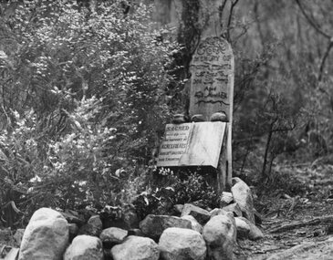 Stawell Historical Society Inc
Photograph, Miss Agnes Folkes' Grave -- close to camping ground near Stony Creek in Halls Gap
... In the centre of the photo is a grave with marker (wooden) also a marble one book shaped with stones in forground....In the centre of the photo is a grave with marker (wooden) also a marble one book shaped with stones in forground. ...Halls Gap. A Lonely Childs Grave (Agnes Folkes) close to camping ground beside walk Stony Creek. The child's parents had a Sawmill nearby. When the child took ill the floods were too great for her parents to get her to a doctor at Pleasant Creek, (Stawell). The child passed away and was buried under the shelter of a pine tree. The wooden marker has long gone, the marble tablet remains. Black and white enlarged photo of a bushland scene in a mountain area. In the centre of the photo is a grave with marker (wooden) also a marble one book shaped with stones in forground.Sacred to the memory of Agnes Folkes - Died July 1870 age 3 months "A Lonely grave, Hall's Gap" printed on mount of photograph.halls gap