Historical information
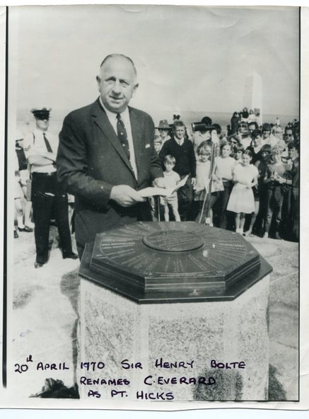
Sir Henry Bolte, premier of Victoria, renamed Cape Everard at Point Hicks during the Centenary of Cook's Landings on April 20, 1970.
There is no land feature at Cook's coordinates of 38°0'S and 148°53'E, a point which lies several miles out to sea and under 50 fathoms of water. Captain Cook invented Point Hicks so that he could conceal Bass Strait and the insularity of Tasmania. The Admiralty had issued its usual instructions to hide strategically important discoveries that could become security risks.
Captain Hicks was James Cook`s senior lieutenant. There has been some dispute as to whether Zachary Hicks actually saw Point Hicks or whether he saw Ram Head about 20 kilometres further up the coast. Although Cook named the promontory Point Hicks it was changed to Cape Everard in 1843..
In 1970 the Victorian government changed the name Cape Everard to 'Point Hicks'. It lies on dry land, about 22 nautical miles (41 km) northeast of Cook's phantom Point Hicks, where it preserves the story of Cook's first landfall in Australia.
Significance
This is a contemporary pictorial record of a significant event in East Gippsland's history.
Physical description
A black / white photograph of a man in a suit making a speech with the audience standing behind him. He is standing in front of an octagonal-shaped directional marker set ointo a stone support. There is a policeman behind him. In the background to the right is a lighthouse.
Inscriptions & markings
on front - "20th April 1970, Sir Henry Bolte renames C. Everard as Pt Hicks" handwritten in block letters