Showing 41 items matching "studley park bridge"
-
![Studley Park [Toll] Bridge, Kew](/media/collectors/550653872162f11fb04854aa/items/579ebf04d0cdd117c4c0815f/item-media/579ebf3ad0cdd117c4c0953e/item-fit-380x285.jpg?cb=6) Kew Historical Society Inc
Kew Historical Society IncPhotograph, Studley Park [Toll] Bridge, Kew, 1870s
... Studley Park [Toll] Bridge, Kew...studley park bridge...‘Studley Park Bridge’ or ‘penny bridge’ linked Church Street in Abbotsford and what is now Yarra Bend Park. ...Kew Historical Society Inc Kew Court House 188 High Street Kew melbourne ‘Studley Park Bridge’ or ‘penny bridge’ linked Church Street in Abbotsford and what is now Yarra Bend Park. ...‘Studley Park Bridge’ or ‘penny bridge’ linked Church Street in Abbotsford and what is now Yarra Bend Park. The privately constructed bridge opened in 1857, gaining its popular name from the toll charged at the Abbotsford end. The engineer of the 485ft wide bridge was Mr. Austin and the builder was ‘Mr Grant, who threw the bridge over the Niagara’. Following the opening of Johnston Street Bridge, declining tolls led to the Bridge falling into disrepair. Badly damaged by the flood of 1891, the Bridge was compulsorily acquired by the Government in 1899, and later dismantled and sold for firewood.This work forms part of the collection assembled by the historian Dorothy Rogers, that was donated to the Kew Historical Society by her son John Rogers in 2015. The manuscripts, photographs, maps, and documents were sourced by her from both family and local collections or produced as references for her print publications. Many were directly used by Rogers in writing ‘Lovely Old Homes of Kew’ (1961) and 'A History of Kew' (1973), or the numerous articles on local history that she produced for suburban newspapers. Most of the photographs in the collection include detailed annotations in her hand. The Rogers Collection provides a comprehensive insight into the working habits of a historian in the 1960s and 1970s. Together it forms the largest privately-donated collection within the archives of the Kew Historical Society.A print, taken in the 1960s by Dorothy Rogers, from an original albumen silver photograph now in the collection of the Kew Historical Society. The photograph shows the toll bridge (also known as the Penny Bridge) from the northern end."P[enny] Toll Bridge - built 1857. from old photo"studley park bridge, penny bridge, bridge, timber bridge, toll bridge -
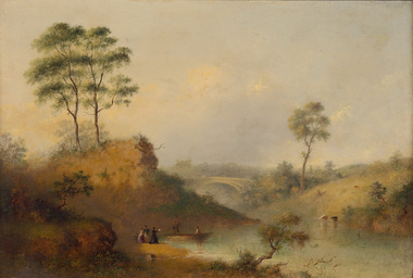 Benalla Art Gallery
Painting, Henry BURN, Studley Park bridge over the Yarra, c. 1860
... Studley Park bridge over the Yarra...Benalla Art Gallery Benalla Art Gallery Benalla Botanical Gardens Bridge Street Benalla high-country Romanticism Painting Landscape Figures Boat Tree Bridge River Animals Water Recto: Not signed, not dated, not titled Oil painting on board, depicting sparse rural landscape by a river and bridge.Gold brushed timber frame and decorative gesso inner corners. Studley Park bridge over the Yarra Painting Henry BURN ...Born: Birmingham, Warwickshire, England 1807; Arrived: Melbourne, Victoria, Australia 1853; Died: Melbounre, Victoria, Australia 1884RomanticismGift of Beverley Brown, 2015Oil painting on board, depicting sparse rural landscape by a river and bridge.Gold brushed timber frame and decorative gesso inner corners. Recto: Not signed, not dated, not titledpainting, landscape, figures, boat, tree, bridge, river, animals, water -
 Kew Historical Society Inc
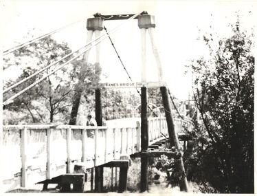
Photograph - Photograph (copy), Kanes Bridge, Studley Park, 195-1955
... Kanes Bridge, Studley Park..."Kanes Bridge" A photographic copy of an older photograph of Kanes Bridge. Kanes Bridge, Studley Park Photograph Photograph (copy) ...In 1928 a footbridge was erected to link Kew with the public golf course across the Yarra. The total cost of construction came to 250 pounds and the bridge became known as Kane's Bridge. During the 1934 floods the bridge was washed downstream, and was subsequently rebuilt. The present form of the bridge resembles the earlier bridge which crossed from the Yarra Bend Asylum to Kew, further upstream. (VHD)This work forms part of the collection assembled by the historian Dorothy Rogers, that was donated to the Kew Historical Society by her son John Rogers in 2015. The manuscripts, photographs, maps, and documents were sourced by her from both family and local collections or produced as references for her print publications. Many were directly used by Rogers in writing ‘Lovely Old Homes of Kew’ (1961) and 'A History of Kew' (1973), or the numerous articles on local history that she produced for suburban newspapers. Most of the photographs in the collection include detailed annotations in her hand. The Rogers Collection provides a comprehensive insight into the working habits of a historian in the 1960s and 1970s. Together it forms the largest privately-donated collection within the archives of the Kew Historical Society.A photographic copy of an older photograph of Kanes Bridge."Kanes Bridge"kanes bridge, yarra river, bridges - kew (vic.) -
 Ballarat Heritage Services
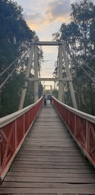
Photograph, Clare Gervasoni, Kane's Bridge, Studley Park, Kew, 2025, 05/05/2025
... Kane's Bridge, Studley Park, Kew, 2025...Bridge...Studley Park...Built for walking traffic, this old walking bridge crosses the Yarra River at the Studley Park Boasthouse It providing convenient access to both sides of the Yarra River. ...Kane's Bridge, Studley Park, Kew, 2025 Photograph Clare Gervasoni ...Built in 1928 and destroyed by flood in 1934 Kane's Bridge, formerly Kane's Suspension Bridge, was then rebuilt in 1935. Built for walking traffic, this old walking bridge crosses the Yarra River at the Studley Park Boasthouse It providing convenient access to both sides of the Yarra River. It is a 2km walk to Dight's Falls. Kane's bridge was named after It was named after T.J. Kane, a councillor at the City of Collingwood.Photographs of Kane's Bridge and engineering details. kane's bridge, studley park, yarra bend park, t.j. kane -
 Kew Historical Society Inc
Work on paper - Sepia Wash & Ink, G B Richardson, Creek and Old Watering Stage, on the Yarra, East Collingwood, 1854, 1854
... The Punt was purchased by the Colonial Government in 1852 and was in use until the opening of the Studley Park Road (Johnston Street) Bridge in 1858 made its continued use redundant...The Punt was purchased by the Colonial Government in 1852 and was in use until the opening of the Studley Park Road (Johnston Street) Bridge in 1858 made its continued use redundant The watercolour is historically significant as perhaps the earliest artwork showing the Yarra River at Kew. ...Blind Creek was located between the Abbotsford Convent and what is now the Collins Bridge in Studley Park. In an 1858 map of East Collingwood by Clement Hodgkinson, in the State Library of Victoria, one can see how the creek was originally a significant landmark in Collingwood; remaining vacant land until a barrel drain enclosed it. The area was later filled in, surveyed and developed. The position where Blind Creek entered the Yarra was in the immediate vicinity of Hodgson’s Punt, which had linked Kew to the other side of the Yarra from 1839. The Punt was purchased by the Colonial Government in 1852 and was in use until the opening of the Studley Park Road (Johnston Street) Bridge in 1858 made its continued use redundantThe point of view selected by the artist for the watercolour is from the banks of Blind Creek in East Collingwood, looking across the Yarra to the Kew side of the river.Inscribed verso 'Creek and Old Watering stage, on the Yarra East Collingwood 1854 / Trees, stage, &c have long since disappeared / [Artist Signature] / FT 110 / Creek itself now being filled in 1903.gb richardson, blind creek - abbotsford, yarra river - abbotsford (vic) - kew (vic), colonial artists, australian art - 19th century, george bouchier richardson -
 Kew Historical Society Inc
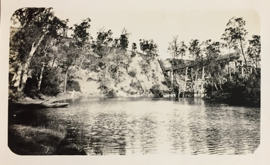
Photograph - Zig-Zag Bridge, 1924
... The wooden bridge was constructed in the 1870s and lasted through numerous floods until its destruction in 1929. A horizontal structure, one climbed steps to reach the higher Yarra Bend bank. At the Studley Park...The wooden bridge was constructed in the 1870s and lasted through numerous floods until its destruction in 1929. A horizontal structure, one climbed steps to reach the higher Yarra Bend bank. At the Studley Park ...Henry Beater Christian (1886-1962) , was a descendant of one of the earliest settler families in Kew. Employed at the Kew Asylum as a 'public servant', he was a skilled amateur photographer, photographing numerous scenes in Kew and on his travels around Victoria. The majority of his photographs date from 1916 to 1929. His finest photographs are housed in two photograph albums. Digital copy of a photograph from page 8 of the 47-page photograph album containing 261 gelatinous silver images, loaned by Diane Washfold with permission given to digitise and hold a copy in our collection. This photograph reveals how the photographer, Henry Christian, positioned himself to take the photograph from the angle in which he was interested. A skilled canoeist, an empty canoe is on the left of the photo that he apparently he used to access his vantage point. His subject, the Zig-Zag Bridge linked the grounds of the Yarra Bend and Kew Asylums. The wooden bridge was constructed in the 1870s and lasted through numerous floods until its destruction in 1929. A horizontal structure, one climbed steps to reach the higher Yarra Bend bank. At the Studley Park end, the bridge descended via a staircase to reach the much lower bank. "Zig-Zag Bridge"henry beater christian (1886-1962), landscape photography, kew (vic.) — yarra river, christian-washfold collection, photograph albums, zig-zag bridge -
 Kew Historical Society Inc
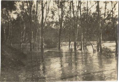
Photograph, Marnie McLeod, Floods of the River Yarra at Kew, 1916
... Studley Park. The river is only about 3 feet from the top of the embankment connecting with the ramp of the bridge on the Studiey Park side. ...Studley Park. The river is only about 3 feet from the top of the embankment connecting with the ramp of the bridge on the Studiey Park side. ...The donation was accompanied by the following letter from the donor: "Hi. I found these in with family photos. Taken by family as Mamie McLeod was living in Fellows Street, Kew, so would be near there. Retain (or discard) as you see fit." [Donor's name and address withheld from public view]. To gain an insight into the flood levels at Kew, it is worth reading newspaper accounts of the event. The Age published an article - Valuable Gardens Destroyed at Kew - on 25 September 1916: "VALUABLE GARDENS DESTROYED AT KEW. From the heights of Studley Park, Kew, a splendid view of the flood waters can be obtained, and yesterday afternoon, despite continuous rain, crowds of citizens assembled there to witness the spectacle. There is a vast stretch of water some 300 or 400 yards broad, above the foot bridge connecting Gipps-street, Collingwood, and Studley Park. The river is only about 3 feet from the top of the embankment connecting with the ramp of the bridge on the Studiey Park side. When the upper llood waters come down it is almost a certainty that tne embankment will be submerged and the bridge rendered impassible. Below the bridge the waters again stretch out, and have submerged all the low-lying land on the Collingwood side and invaded the back premises ot the Kodak Co., Phoenix Biscuit Factory, a tannery adjoining thereto, the Shamrock Brewery, and Chinese gardens in the vicinity. At Walmer-street-bridge, at the end of Studley Park, the low-lying land on the Kew side is covered with water to the depth of many feet. Tlie land in question is owned in a great part by Mr Frank Lavers who haa gone in for intense culture on a pretty liberal scale on both the slopes of the hill and on the river flat. On the latter he is cultivating many acres of asparagus, and has at a considerable cost spent three years in preparing the ground and installing an irrigation system, reticulated from the Yan Yean water supply. This year the asparagus was put down, and the plants were in a promising condition. Tlie flood waters are now flowing fast over the land. The crop is ruined, and three years' work and expenditure destroyed. Mr. Laver's private residence fortunately is high above flood level, but two houses he owns off Young-street have been flooded out. Having been warned in time, the tenants removed their furniture hefore the water came down to Mr. Laver's residence, where they themselves have been given accommodation in the meantime. All the river flats in East Kew are under water. One or two low-lying houses have been flooded. Chipperfield's boat shed at Willsmere is nearly covered, and some Chinese gardens in the vicinity are several feet under water."This, and the other three photographs donated of floods in Kew are believed to be the earliest in the collection. Together with our original MMBW River Yarra map showing flood levels, these items, when compared allow researchers to gain a visual perspective of the extent of the flood in 1916. Black and white photograph of flooded trees in Kew with rising dry ground in distance.Inscription on reverse in pencil: "Flood River Yarra Kew Vic"river yarra, kew, floods 1916 -
 Kew Historical Society Inc
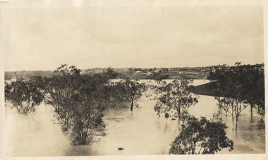
Photograph, Marnie McLeod, Floods on the River Yarra at Kew, 1916
... Studley Park. The river is only about 3 feet from the top of the embankment connecting with the ramp of the bridge on the Studiey Park side. ...Studley Park. The river is only about 3 feet from the top of the embankment connecting with the ramp of the bridge on the Studiey Park side. ...The donation was accompanied by the following letter from the donor: "Hi. I found these in with family photos. Taken by family as Mamie McLeod was living in Fellows Street, Kew, so would be near there. Retain (or discard) as you see fit." [Donor's name and address withheld from public view]. To gain an insight into the flood levels at Kew, it is worth reading newspaper accounts of the event. The Age published an article - Valuable Gardens Destroyed at Kew - on 25 September 1916: "VALUABLE GARDENS DESTROYED AT KEW. From the heights of Studley Park, Kew, a splendid view of the flood waters can be obtained, and yesterday afternoon, despite continuous rain, crowds of citizens assembled there to witness the spectacle. There is a vast stretch of water some 300 or 400 yards broad, above the foot bridge connecting Gipps-street, Collingwood, and Studley Park. The river is only about 3 feet from the top of the embankment connecting with the ramp of the bridge on the Studiey Park side. When the upper llood waters come down it is almost a certainty that tne embankment will be submerged and the bridge rendered impassible. Below the bridge the waters again stretch out, and have submerged all the low-lying land on the Collingwood side and invaded the back premises ot the Kodak Co., Phoenix Biscuit Factory, a tannery adjoining thereto, the Shamrock Brewery, and Chinese gardens in the vicinity. At Walmer-street-bridge, at the end of Studley Park, the low-lying land on the Kew side is covered with water to the depth of many feet. Tlie land in question is owned in a great part by Mr Frank Lavers who haa gone in for intense culture on a pretty liberal scale on both the slopes of the hill and on the river flat. On the latter he is cultivating many acres of asparagus, and has at a considerable cost spent three years in preparing the ground and installing an irrigation system, reticulated from the Yan Yean water supply. This year the asparagus was put down, and the plants were in a promising condition. Tlie flood waters are now flowing fast over the land. The crop is ruined, and three years' work and expenditure destroyed. Mr. Laver's private residence fortunately is high above flood level, but two houses he owns off Young-street have been flooded out. Having been warned in time, the tenants removed their furniture hefore the water came down to Mr. Laver's residence, where they themselves have been given accommodation in the meantime. All the river flats in East Kew are under water. One or two low-lying houses have been flooded. Chipperfield's boat shed at Willsmere is nearly covered, and some Chinese gardens in the vicinity are several feet under water."This, and the other three photographs donated of floods in Kew are believed to be the earliest in the collection. Together with our original MMBW River Yarra map showing flood levels, these items, when compared allow researchers to gain a visual perspective of the extent of the flood in 1916. Panoramic view, believed to be looking north towards Fairfield from the Zig-Zag Bridge on the River Yarra. The inscription on the reverese identifies it as taken before 1920.Inscription on reverse in ink "(pre 1920) Flood from Zig-zag bridge Yarra River, Kew Vic."river yarra, kew, floods 1916, zig-zag bridge -
 Kew Historical Society Inc
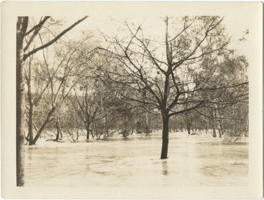
Photograph, Marnie McLeod, Flood, River Yarra, Kew, 1916
... Studley Park. The river is only about 3 feet from the top of the embankment connecting with the ramp of the bridge on the Studiey Park side. ...Studley Park. The river is only about 3 feet from the top of the embankment connecting with the ramp of the bridge on the Studiey Park side. ...The donation was accompanied by the following letter from the donor: "Hi. I found these in with family photos. Taken by family as Mamie McLeod was living in Fellows Street, Kew, so would be near there. Retain (or discard) as you see fit." [Donor's name and address withheld from public view]. To gain an insight into the flood levels at Kew, it is worth reading newspaper accounts of the event. The Age published an article - Valuable Gardens Destroyed at Kew - on 25 September 1916: "VALUABLE GARDENS DESTROYED AT KEW. From the heights of Studley Park, Kew, a splendid view of the flood waters can be obtained, and yesterday afternoon, despite continuous rain, crowds of citizens assembled there to witness the spectacle. There is a vast stretch of water some 300 or 400 yards broad, above the foot bridge connecting Gipps-street, Collingwood, and Studley Park. The river is only about 3 feet from the top of the embankment connecting with the ramp of the bridge on the Studiey Park side. When the upper llood waters come down it is almost a certainty that tne embankment will be submerged and the bridge rendered impassible. Below the bridge the waters again stretch out, and have submerged all the low-lying land on the Collingwood side and invaded the back premises ot the Kodak Co., Phoenix Biscuit Factory, a tannery adjoining thereto, the Shamrock Brewery, and Chinese gardens in the vicinity. At Walmer-street-bridge, at the end of Studley Park, the low-lying land on the Kew side is covered with water to the depth of many feet. Tlie land in question is owned in a great part by Mr Frank Lavers who haa gone in for intense culture on a pretty liberal scale on both the slopes of the hill and on the river flat. On the latter he is cultivating many acres of asparagus, and has at a considerable cost spent three years in preparing the ground and installing an irrigation system, reticulated from the Yan Yean water supply. This year the asparagus was put down, and the plants were in a promising condition. Tlie flood waters are now flowing fast over the land. The crop is ruined, and three years' work and expenditure destroyed. Mr. Laver's private residence fortunately is high above flood level, but two houses he owns off Young-street have been flooded out. Having been warned in time, the tenants removed their furniture hefore the water came down to Mr. Laver's residence, where they themselves have been given accommodation in the meantime. All the river flats in East Kew are under water. One or two low-lying houses have been flooded. Chipperfield's boat shed at Willsmere is nearly covered, and some Chinese gardens in the vicinity are several feet under water."This, and the other three photographs donated of floods in Kew are believed to be the earliest in the collection. Together with our original MMBW River Yarra map showing flood levels, these items, when compared allow researchers to gain a visual perspective of the extent of the flood in 1916. Small black and white photograph of flooded trees in Kew.Inscription on reverse in ink "Flood R. Yarra Kew Vicriver yarra, kew, floods 1916 -
 Kew Historical Society Inc
Archive (Sub-series) - Subject File, Kew Historical Society, Kane’s Bridge, 1958
... ...kane's bridge - studley park - yarra bend park...Typically files will contain primary and secondary sources. kew historical society - archives kew - history kane's bridge - studley park - yarra bend park Archive file that contains two newspaper articles with brief information about the history of the bridge. ...Various partiesReference, Research, InformationSecondary Values (KHS Imposed Order)Subject file that contains two newspaper articles with brief information about the history of the bridge.kew historical society - archives, kew - history, kane's bridge - studley park - yarra bend parkkew historical society - archives, kew - history, kane's bridge - studley park - yarra bend park -
 Kew Historical Society Inc
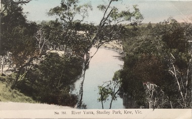
Postcard, The VSM.Series, No.351. River Yarra, Studley Park, Kew, Vic, c.1905
... Studley Park, circa 1905. The postcard, which has handwritten notes on the reverse. It was printed in Prussia as part of the Victoria Stamp Market (VSM) Series. river yarra victoria stamp market (vsm) series postcards Donated by Miss B. Challen. ?Taken from bend above Galatea Point, looking north. Identified by Darcy Dugan, Yarra Bend Parks. Coloured postcard of the Yarra River looking north from Galatea Point, near the Johnson Street Bridge ...This is a colour postcard of the River Yarra at Studley Park, circa 1905. The postcard, which has handwritten notes on the reverse. It was printed in Prussia as part of the Victoria Stamp Market (VSM) Series. Coloured postcard of the Yarra River looking north from Galatea Point, near the Johnson Street Bridge.Donated by Miss B. Challen. ?Taken from bend above Galatea Point, looking north. Identified by Darcy Dugan, Yarra Bend Parks.river yarra, victoria stamp market (vsm) series, postcards -
 Kew Historical Society Inc
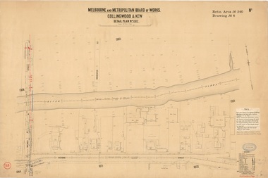
Plan, Melbourne & Metropolitan Board of Works : Borough of Kew : Detail Plan No.1302, 1910
... Walmer Street and its bridge stretched, then and now, from Studley Park Road to Victoria Street, Richmond. ...Walmer Street and its bridge stretched, then and now, from Studley Park Road to Victoria Street, Richmond. ...The Melbourne and Metropolitan Board of Works (MMBW) plans were produced from the 1890s to the 1950s. They were crucial to the design and development of Melbourne's sewerage and drainage system. The plans, at a scale of 40 feet to 1 inch (1:480), provide a detailed historical record of Melbourne streetscapes and environmental features. Each plan covers one or two street blocks (roughly six streets), showing details of buildings, including garden layouts and ownership boundaries, and features such as laneways, drains, bridges, parks, municipal boundaries and other prominent landmarks as they existed at the time each plan was produced. (Source: State Library of Victoria)This plan forms part of a large group of MMBW plans and maps that was donated to the Society by the Mr Poulter, City Engineer of the City of Kew in 1989. Within this collection, thirty-five hand-coloured plans, backed with linen, are of statewide significance as they include annotations that provide details of construction materials used in buildings in the first decade of the 20th century as well as additional information about land ownership and usage. The copies in the Public Record Office Victoria and the State Library of Victoria are monochrome versions which do not denote building materials so that the maps in this collection are invaluable and unique tools for researchers and heritage consultants. A number of the plans are not held in the collection of the State Library of Victoria so they have the additional attribute of rarity.Original survey plan, issued by the MMBW to a contractor with responsibility for constructing sewers in the area identified on the plan within the Borough of Kew. The plan was at some stage hand-coloured, possibly by the contractor, but more likely by officers working in the Engineering Department of the Borough and later Town, then City of Kew. The hand-coloured sections of buildings on the plan were used to denote masonry or brick constructions (pink), weatherboard constructions (yellow), and public buildings (grey). The absence of buildings and or property in Kew facing the Yarra is the most notable feature of this plan. Walmer Street and its bridge stretched, then and now, from Studley Park Road to Victoria Street, Richmond. On the Richmond side of the Yarra, there was evidence in 1904 of industry (‘Wool shed’; Soap Works’) and entertainment (‘Skittle Alley’). In reality, another Plan (No.1303) shows Chinese Gardens bordering the Yarra on the Kew side and buildings in Young Street.melbourne and metropolitan board of works, detail plans, mmbw 1302, cartography -
Kew Historical Society Inc
Archive (Sub-series) - Subject File, Kew Historical Society, Houses [Kew], 1980
... Studley Park Road in 1981. In the photocopy about Ellesmore, there is also a separate article on the proposed replacement of the Walmer Street Bridge. ...Studley Park Road in 1981. In the photocopy about Ellesmore, there is also a separate article on the proposed replacement of the Walmer Street Bridge. ...Various partiesReference, Research, InformationSecondary Values (KHS Imposed Order)Assorted printed materials, some published, such as: ‘What House is That? A guide to Victorian housing’ (Heritage Victoria, 2004), and guidelines for researching the history of a house (Fact Sheet, City of Boroondara). There is an article from the Progress Press about the demolition of Ellesmore, 80 Princess Street in 1977 (the article includes photographs of the demolition), Elizabeth Mackie’s notes on Myrtle Hill, and an article on the restoration of Mynda, Molesworth Street that was published in the Trust News (1987). Mrs Sewell of Stawell Street wrote handwritten notes/recollections about Cradley in Studley Park Road in 1981. In the photocopy about Ellesmore, there is also a separate article on the proposed replacement of the Walmer Street Bridge. There is also correspondence and an article on Stanhope on the corner of Burke and Cotham Roads. The file includes general real estate information and data.kew historical society - archives, kew - history, myrtle hill (kew), ellesmore - 80 princess street - kew (vic), mynda - molesworth street - kew (vic), stanhope - burke road - cotham road - kew (vic), cradley - studley park road - kew (vic), 17 queen street - kew (vic.)kew historical society - archives, kew - history, myrtle hill (kew), ellesmore - 80 princess street - kew (vic), mynda - molesworth street - kew (vic), stanhope - burke road - cotham road - kew (vic), cradley - studley park road - kew (vic), 17 queen street - kew (vic.) -
Kew Historical Society Inc
Journal, Kew Historical Society, Newsletter No.115, June 2016
... More Examples of Lost Kew: Studley Park Toll Bridge, Salvation Army Citadel, Harp of Erin Hotel, Kew Recreation Hall p9. ...What Price Memory? / Robert Baker p1. What’s On - June to September: Exhibitions, Monthly meetings p3. Heritage Issues: Dorothy Rogers Reserve / Brad Miles p4. The Great War in Kew 1916: The conscription debate / Andrew Frost p6. Victorian Collections [Hat collection] / Robert Baker p7. More Examples of Lost Kew: Studley Park Toll Bridge, Salvation Army Citadel, Harp of Erin Hotel, Kew Recreation Hall p9. Membership & Donations p10.Published quarterly since 1977, the newsletters of the Kew Historical Society contain significant research by members exploring relevant aspects of the Victorian and Australian Framework of Historical Themes. Frequently, articles on people, places and artefacts are the only source of information about an aspect of Kew, and Melbourne’s history.non-fictionWhat Price Memory? / Robert Baker p1. What’s On - June to September: Exhibitions, Monthly meetings p3. Heritage Issues: Dorothy Rogers Reserve / Brad Miles p4. The Great War in Kew 1916: The conscription debate / Andrew Frost p6. Victorian Collections [Hat collection] / Robert Baker p7. More Examples of Lost Kew: Studley Park Toll Bridge, Salvation Army Citadel, Harp of Erin Hotel, Kew Recreation Hall p9. Membership & Donations p10. -
 Kew Historical Society Inc
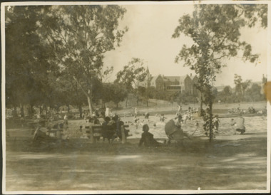
Photograph - Wading Pools : Studley Park Reserve
... In the 1930s, the Studley Park Trust decided to cater for young children by constructing wading pools in the Studley Park Reserve where the Collins Bridge crosses into Kew. ...Black and white print positive of the former wading pools in the Studley Park Reserve (now Andrews Reserve) on the Kew side of the Collins Bridge. ...The eventual closing date of the Studley Park Pools has not been discovered, but it was clearly still in existence in 1940 when a representative of the Trust described the facility as one of many public fixtures requiring regular maintenance. Andrews Reserve -- Kew Studley park trust wading pools -- kew studley park reserve Reverse: "Collins Bridge ...In the 1930s, the Studley Park Trust decided to cater for young children by constructing wading pools in the Studley Park Reserve where the Collins Bridge crosses into Kew. The earliest references to the pools in newspaper articles and letters to the editor appear in the late 1930s. The eventual closing date of the Studley Park Pools has not been discovered, but it was clearly still in existence in 1940 when a representative of the Trust described the facility as one of many public fixtures requiring regular maintenance. Black and white print positive of the former wading pools in the Studley Park Reserve (now Andrews Reserve) on the Kew side of the Collins Bridge. In the foreground adults are sitting on seats while small children play in the pools. The Abbotsford Convent is in the background.Reverse: "Collins Bridge / Wading pools Collins Bridge"andrews reserve -- kew, studley park trust, wading pools -- kew, studley park reserve -
 Kew Historical Society Inc
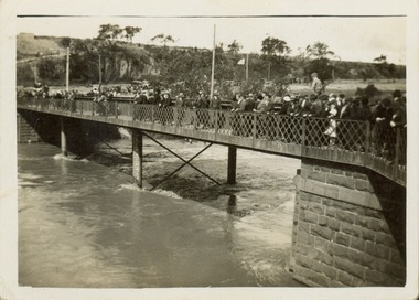
Photograph - Second Johnston Street Bridge in Flood, 1934
... bridge / Johnston St. Studly Park Rd. Bridge looking towards Kew / 1st bridge 1858–1876, 2nd bridge built (bad bend), 1876–1958, 3rd bridge 1958, lined up Johnston St and Studley Park Rd."...bridge / Johnston St. Studly Park Rd. Bridge looking towards Kew / 1st bridge 1858–1876, 2nd bridge built (bad bend), 1876–1958, 3rd bridge 1958, lined up Johnston St and Studley Park Rd." ...Original, small black and white print photograph of crowds lining the Johnston Street Bridge watching the flood waters below. The annotation on the reverse clarifies that Kew is in the distance.Annotated on reverse: "Gift of G.S. Beard / 2nd bridge / Johnston St. Studly Park Rd. Bridge looking towards Kew / 1st bridge 1858–1876, 2nd bridge built (bad bend), 1876–1958, 3rd bridge 1958, lined up Johnston St and Studley Park Rd."johnston street bridge, bridges - yarra river -- kew (vic.), flood -- 1934 -
 Kew Historical Society Inc
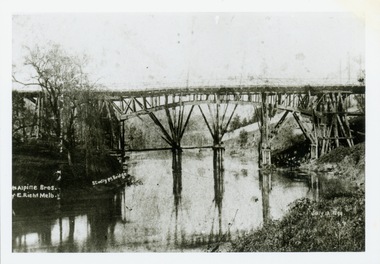
Print, Studley Pk Toll Bridge, July 12 1899
... Black and white print photograph of the wooden 'Penny Bridge' at Studley Park. The name was colloquially arrived at as a penny wa the toll one paid to cross the bridge. ...Kew Historical Society Inc Kew Court House 188 High Street Kew melbourne toll bridges -- river yarra bridges - yarra river -- kew (vic.) penny bridge Reverse: "Studley Pk Toll Bridge / joining Church Street Abbotsford / Penny Bridge" Black and white print photograph of the wooden 'Penny Bridge' at Studley Park. ...Black and white print photograph of the wooden 'Penny Bridge' at Studley Park. The name was colloquially arrived at as a penny wa the toll one paid to cross the bridge. The copy of the postcard identifies the photographers as McAlpin Bros, Richmond.Reverse: "Studley Pk Toll Bridge / joining Church Street Abbotsford / Penny Bridge"toll bridges -- river yarra, bridges - yarra river -- kew (vic.), penny bridge -
 Kew Historical Society Inc
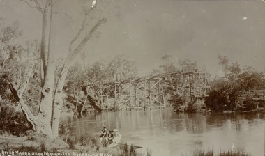
Postcard, River Yarra near Macauleys' Boathouse Kew
... Sepia postcard of the Zig-zaf Bridge joining Yarra Bend and Studley Park. In the foreground is a rowboat in which a man is standing, behind whom are two women in hats and a young child. .... / Kew side" Sepia postcard of the Zig-zaf Bridge joining Yarra Bend and Studley Park. In the foreground is a rowboat in which a man is standing, behind whom are two women in hats and a young child. ...Sepia postcard of the Zig-zaf Bridge joining Yarra Bend and Studley Park. In the foreground is a rowboat in which a man is standing, behind whom are two women in hats and a young child. The man appears to be pushing the boat away from the Bank. In the distance is the wooden Zig-Zag Bridge, constructed in the 1870s to link the Yarra Bend and Kew Lunatic Asylums. [Destroyed by flood, 1929.]Obverse: "River Yarra near Macauleys' Boathouse Kew". Reverse: "Zig Zag Bridge / Gift from L Bennett 1980 / Bridge between Old Asylum & new Mental Hosp. / Kew side"zig-zag bridge -- kew (vic.), bridges -- river yarra, bridges -- kew (vic.) -
 Kew Historical Society Inc
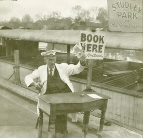
Photograph - Hicks' Cruises ticket seller at Princess Bridge, c.1953
... Closeup photograph of a ticket seller touting for business for a tourist ferry moored at Princess Bridge The sign on the boat identifies the destination of the ferry as 'Studley Park via Hawthorn Tea Gardens'. ...Hicks' cruises tourism -- melbourne (vic.) river yarra Studley park hawthorn tea gardens Closeup photograph of a ticket seller touting for business for a tourist ferry moored at Princess Bridge The sign on the boat identifies the destination of the ferry as 'Studley Park via Hawthorn Tea Gardens'. ...Commercially-operated boat tours on the Maribyrnong and Yarra Rivers in Melbourne were a major tourist attraction, especially in the first half of the twentieth century. A number of companies ran ferries and motor-launches to locations such as the Riverview Tea Gardens (1909-1947) at Ascot Vale, and the Hawthorn Tea Gardens on the corner of Power Street and Riversdale Road. One of the families which ran these services was Hicks Bros, which from circa 1921 operated a ferry service from Princess Walk (Melbourne) to Studley Park. This is one of a series of 17 black and white undated photographic proofs donated to the Kew Historical Society in 2013 by the Queenscliffe Historical Museum. The series includes images of individuals, tea rooms, ferries, motor launches, ocean liners and tugs. In 1953, the owner of Hicks Bros was involved in an inquest into the drowning of a Ukrainian tourist on a ferry operated by Melbourne Ferries, a rival firm. In published reports of the inquest, reference is made to a number of photographs taken by Robert Irvine Atchison, part-owner of Hicks Bros. As the reverse of the photographs indicates copyright is held by the State of Victoria, the collection may have derived from that year.Closeup photograph of a ticket seller touting for business for a tourist ferry moored at Princess Bridge The sign on the boat identifies the destination of the ferry as 'Studley Park via Hawthorn Tea Gardens'. The ferry is empty of passengers.hicks' cruises, tourism -- melbourne (vic.), river yarra, studley park, hawthorn tea gardens -
Kew Historical Society Inc
Journal, The Kewriosity Sheet Vol.1 No.10 : March 1980
... Bridge Centre] /p2. Playgroup [Uniting Church Highbury Grove] / p2. Youth Clubs [St Hilary's Church of England] / p2. Your news is good news / p2. Kintore Social Club A.G.M. / p2. A story to tell, 1803 [Studley Park ...What's doing in Kew for March / p1. His Majesty, King Kewfun presents - Kew Community Festival [Festival time] / p1. Kew Philharmonic Society/ p1. Where to pick up your Kewriosity Sheet / p1. Kewrious happenings / p2. Photoflora '80 [photographic competition] / p2. Choral Easter Music Service / p2. Kew Historical Society / Elizabeth Mackie p2. Bridge [Melbourne Bridge Centre] /p2. Playgroup [Uniting Church Highbury Grove] / p2. Youth Clubs [St Hilary's Church of England] / p2. Your news is good news / p2. Kintore Social Club A.G.M. / p2. A story to tell, 1803 [Studley Park] / p2. What do you do when no-one seems to have the right answer? [Citizens' Advice Bureau] / p2. Council News - 'Kew Plans for Junction' [+ Mayoral Neighbourhood Barbeque] / p2.The Kewriosity Sheet (1979-83) was first published in the City of Kew (Victoria) in June 1979 as a two-sided 'community newssheet'. It aimed to: 'share news about Kew happenings and Kew people, and to exchange ideas about living in Kew'. Later issues gradually evolved into a 4-page, quarto sized publication. The Kewriosity Sheet was superseded by the Kew Council publication 'Kewriosity' (1983-1994).non-fictionWhat's doing in Kew for March / p1. His Majesty, King Kewfun presents - Kew Community Festival [Festival time] / p1. Kew Philharmonic Society/ p1. Where to pick up your Kewriosity Sheet / p1. Kewrious happenings / p2. Photoflora '80 [photographic competition] / p2. Choral Easter Music Service / p2. Kew Historical Society / Elizabeth Mackie p2. Bridge [Melbourne Bridge Centre] /p2. Playgroup [Uniting Church Highbury Grove] / p2. Youth Clubs [St Hilary's Church of England] / p2. Your news is good news / p2. Kintore Social Club A.G.M. / p2. A story to tell, 1803 [Studley Park] / p2. What do you do when no-one seems to have the right answer? [Citizens' Advice Bureau] / p2. Council News - 'Kew Plans for Junction' [+ Mayoral Neighbourhood Barbeque] / p2. community publications --- kew (vic.), the kewriosity sheet, newsletters - kew (vic.) -
Kew Historical Society Inc
Journal, The Kewriosity Sheet Vol.3 No.3 : September 1981
... Park Church] / p3. Mission Spring Fair [Missionary Sisters of St Peter Claver / p3. The gateway to Kew [Charles Grimes Expedition; Johnston Street Bridge; Studley Park Road; Raheen; Campion Hall; Burke Hall; Studley House; Villa Alba] / Elizabeth Mackie p4. ...Home tutors for migrants [Jill Manton] / p1. Harp, Browse and Buy [Harp Browse and Buy Shop; Victoria Schizophrenia Fellowship] / p1. East Kew Uniting Church / p1. Spring-time Fair [East Kew Uniting Church] /p2. Do you know? [Parents of Disabled Persons] / p2. What's doing in Kew for September / p2&3 Women's Recreation Program /p3. Guest to preach at Kew Baptist Church [Rev. Brian Willersdorf] / p3. Minibus drivers and jockeys [Meals on Wheels] / p3. Hyde Park Fellowship [Hyde Park Church] / p3. Mission Spring Fair [Missionary Sisters of St Peter Claver / p3. The gateway to Kew [Charles Grimes Expedition; Johnston Street Bridge; Studley Park Road; Raheen; Campion Hall; Burke Hall; Studley House; Villa Alba] / Elizabeth Mackie p4. Council News - Family and Community Services (FACS) Programme; Community Service Grants; Deafness Awareness Week; ] / p4.The Kewriosity Sheet (1979-83) was first published in the City of Kew (Victoria) in June 1979 as a two-sided 'community newssheet'. It aimed to: 'share news about Kew happenings and Kew people, and to exchange ideas about living in Kew'. Later issues gradually evolved into a 4-page, quarto sized publication. The Kewriosity Sheet was superseded by the Kew Council publication 'Kewriosity' (1983-1994).non-fictionHome tutors for migrants [Jill Manton] / p1. Harp, Browse and Buy [Harp Browse and Buy Shop; Victoria Schizophrenia Fellowship] / p1. East Kew Uniting Church / p1. Spring-time Fair [East Kew Uniting Church] /p2. Do you know? [Parents of Disabled Persons] / p2. What's doing in Kew for September / p2&3 Women's Recreation Program /p3. Guest to preach at Kew Baptist Church [Rev. Brian Willersdorf] / p3. Minibus drivers and jockeys [Meals on Wheels] / p3. Hyde Park Fellowship [Hyde Park Church] / p3. Mission Spring Fair [Missionary Sisters of St Peter Claver / p3. The gateway to Kew [Charles Grimes Expedition; Johnston Street Bridge; Studley Park Road; Raheen; Campion Hall; Burke Hall; Studley House; Villa Alba] / Elizabeth Mackie p4. Council News - Family and Community Services (FACS) Programme; Community Service Grants; Deafness Awareness Week; ] / p4. community publications --- kew (vic.), the kewriosity sheet, newsletters - kew (vic.) -
 Kew Historical Society Inc
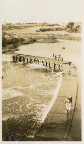
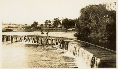
Photograph - Victorian Canoe Club, Dight's Falls, Studley Park, 1920-30
... Studley Park, Kew. The album includes a photographic record of canoe construction and also locations in Studley Park and Kew where the canoes were used. The subject of this photograph is identified as 'Dight's Falls, Studley Park'.The view is from above and shows an early trestle bridge across the Falls on which people, possibly members of the Club, are walking or standing. ...Studley Park" One of 24 labelled photos in part album, originating from the Victorian Canoe Club, which had its headquarters in Studley Park, Kew. The album includes a photographic record of canoe construction and also locations in Studley Park and Kew where the canoes were used. The subject of this photograph is identified as 'Dight's Falls, Studley Park'.The view is from above and shows an early trestle bridge ...Canoeing on the River Yarra at Melbourne was an important and widespread recreational pursuit for Melbournians, especially in the first half of the twentieth century. The Victorian Canoe Club was formed in 1912 at a meeting in Melbourne and its first committee elected in the same year. Records indicate that the Club continued into at least the 1950s .The album has historic and social significance as a record of recreational activities (as well as canoe making) in the early years of the twentieth century. It has local significance as the site of the headquarters of the Club was in Studley Park. A number of photographs in the album provide vistas of Kew on the Yarra that are otherwise unavailable.One of 24 labelled photos in part album, originating from the Victorian Canoe Club, which had its headquarters in Studley Park, Kew. The album includes a photographic record of canoe construction and also locations in Studley Park and Kew where the canoes were used. The subject of this photograph is identified as 'Dight's Falls, Studley Park'.The view is from above and shows an early trestle bridge across the Falls on which people, possibly members of the Club, are walking or standing. The point of view would appear to be looking up river towards Fairfield."Dyghts Falls, Studley Park"victorian canoe club, river yarra, burke road -- kew (vic.), dight's falls -- fairfield (vic.), dight's falls -- kew (vic.), dight's falls -- yarra river -
 Kew Historical Society Inc
Photograph - Victorian Canoe Club, Dight's Falls, Studley Park, 1920-30
... Studley Park, Kew. The album includes a photographic record of canoe construction and also locations in Studley Park and Kew where the canoes were used. The subject of this photograph is identified as 'Dight's Falls, Studley Park'.The view shows an early trestle bridge across the Falls on which people, possibly members of the Club, are standing. ...Studley Park" One of 24 labelled photos in part album, originating from the Victorian Canoe Club, which had its headquarters in Studley Park, Kew. The album includes a photographic record of canoe construction and also locations in Studley Park and Kew where the canoes were used. The subject of this photograph is identified as 'Dight's Falls, Studley Park'.The view shows an early trestle bridge ...Canoeing on the River Yarra at Melbourne was an important and widespread recreational pursuit for Melbournians, especially in the first half of the twentieth century. The Victorian Canoe Club was formed in 1912 at a meeting in Melbourne and its first committee elected in the same year. Records indicate that the Club continued into at least the 1950s .The album has historic and social significance as a record of recreational activities (as well as canoe making) in the early years of the twentieth century. It has local significance as the site of the headquarters of the Club was in Studley Park. A number of photographs in the album provide vistas of Kew on the Yarra that are otherwise unavailable.One of 24 labelled photos in part album, originating from the Victorian Canoe Club, which had its headquarters in Studley Park, Kew. The album includes a photographic record of canoe construction and also locations in Studley Park and Kew where the canoes were used. The subject of this photograph is identified as 'Dight's Falls, Studley Park'.The view shows an early trestle bridge across the Falls on which people, possibly members of the Club, are standing. The point of view would appear to be looking up river towards Fairfield."Dyghts Falls, Studley Park"victorian canoe club, river yarra, burke road -- kew (vic.), dight's falls -- fairfield (vic.), dight's falls -- kew (vic.), dight's falls -- yarra river -
 Kew Historical Society Inc
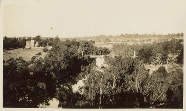
Photograph - Victorian Canoe Club, V.C.C. site, Studley Park, 1920-30
... Bridge...Studley park...Studley Park, Kew. The album includes a photographic record of canoe construction and also locations in Studley Park and Kew where the canoes were used. The subject of this photograph is identified as 'V.C.C. site, Studley Park'.The panoramic view shows a number of important landmarks during this period. On the left of the photograph is one of the remaining buildings of the Yarra Bend Asylum. Stretching across the river is a suspension bridge...Studley Park. A number of photographs in the album provide vistas of Kew on the Yarra that are otherwise unavailable. Victorian Canoe Club River Yarra Canoe clubs Yarra Bend Asylum Suspension bridge -- Kew Kane's Bridge Studley park "V.C.C. site, Studley Park" One of 24 labelled photos in part album, originating from the Victorian Canoe Club, which had its headquarters in Studley Park, Kew. ...Canoeing on the River Yarra at Melbourne was an important and widespread recreational pursuit for Melbournians, especially in the first half of the twentieth century. The Victorian Canoe Club was formed in 1912 at a meeting in Melbourne and its first committee elected in the same year. Records indicate that the Club continued into at least the 1950s .The album has historic and social significance as a record of recreational activities (as well as canoe making) in the early years of the twentieth century. It has local significance as the site of the headquarters of the Club was in Studley Park. A number of photographs in the album provide vistas of Kew on the Yarra that are otherwise unavailable.One of 24 labelled photos in part album, originating from the Victorian Canoe Club, which had its headquarters in Studley Park, Kew. The album includes a photographic record of canoe construction and also locations in Studley Park and Kew where the canoes were used. The subject of this photograph is identified as 'V.C.C. site, Studley Park'.The panoramic view shows a number of important landmarks during this period. On the left of the photograph is one of the remaining buildings of the Yarra Bend Asylum. Stretching across the river is a suspension bridge on the site of the present Kane's Bridge. The reference to the V.C.C. site is unclear within the context of the photo which appears to be taken from the vicinity of the Johnston Street Bridge."V.C.C. site, Studley Park"victorian canoe club, river yarra, canoe clubs, yarra bend asylum, suspension bridge -- kew, kane's bridge, studley park -
 Kew Historical Society Inc
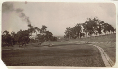
Photograph - The Boulevard at Kew, 1937
... Key dates in the construction this section the road include: 1933 when Kew Council supported the construction of the road from Studley Park to the Kew Asylum; and 1936 when the road from the Johnston Street Bridge to the Chandler Highway was opened. ...Key dates in the construction this section the road include: 1933 when Kew Council supported the construction of the road from Studley Park to the Kew Asylum; and 1936 when the road from the Johnston Street Bridge to the Chandler Highway was opened. ...The Yarra Scenic Boulevard stretching from Hawthorn to the Chandler Highway was completed as a major project between 1933 and 1936 during a period of significant unemployment. Key dates in the construction this section the road include: 1933 when Kew Council supported the construction of the road from Studley Park to the Kew Asylum; and 1936 when the road from the Johnston Street Bridge to the Chandler Highway was opened. The inscription on the reverse of the photo 'Boulevard Fairfield' is misleading as there is no section of the Boulevard in Fairfield. A more likely interpretation is that it is a photograph of the Kew section of the Yarra Boulevard with the factories of Fairfield in the distance.Rare early photograph of the Yarra Boulevard, taken one year after the opening of the road. The photograph is an important historical record of the results of 'Susso' labor in the creation of major works in Melbourne by the Victorian Government. Original, black and white positive print of the Boulevard at Kew in 1937. Key aspects to note about the photograph is that the road is bituminised; that the gutters are concreted; that the kerb is constructed of concrete blocks; and that there is an unmade footpath on what appears to be the right hand side of the road. The landscape is sparsely treed, and those trees that remain are presumably remnant vegetation. At the right, the land is fenced. The land at the left falls away sharply to the river below. On the horizon, at left, there is an industrial complex including a tall chimney that is burning fuel creating smoke. "Boulevard Fairfield" great depression, susso projects, roads -- kew (vic.), yarra boulevard, yarra valley -
 Kew Historical Society Inc
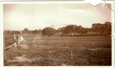
Photograph - Yarra Flats near Burke Road Bridge, 1937
... By the 1930s much of this area remained open farmland, bought at auction for dairy farming in the 1840s. studley park -- kew (vic.) Inscribed verso: "Yarra Flats near Burke Rd Bridge 1937" Original, black and white positive print of what is said to be the Yarra Flats near Burke Road Bridge. ...Land along the Yarra River in Kew is now either designated open space, parkland or public golf links. By the 1930s much of this area remained open farmland, bought at auction for dairy farming in the 1840s.Original, black and white positive print of what is said to be the Yarra Flats near Burke Road Bridge. On the horizon, building can be seen, whereas in the middle ground, farm fencing and a windmill are the main features as well as remnant Eucalypts. Inscribed verso: "Yarra Flats near Burke Rd Bridge 1937" studley park -- kew (vic.) -
 Kew Historical Society Inc
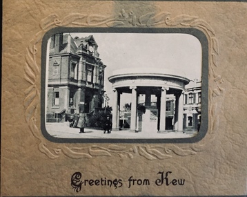
Postcard, Greetings from Kew, c.1928
... Individual postcards include: Studley Park Road, River Yarra showing new Bridge [Chandler Hwy], High Street showing soldier's memorial, River Yarra at Victoria Bridge, The Yarra at Studley Park, Holy Trinity Church, the [Alexandra] Gardens, New Yarra Bridge [Burke Rd], Soldiers' Memorial and Post Office Kew...Individual postcards include: Studley Park Road, River Yarra showing new Bridge [Chandler Hwy], High Street showing soldier's memorial, River Yarra at Victoria Bridge, The Yarra at Studley Park, Holy Trinity Church, the [Alexandra] Gardens, New Yarra Bridge [Burke Rd], Soldiers' Memorial and Post Office Kew Greetings from Kew Postcard ...An item from an outstanding and diverse photographic collection, assembled by members of the Christian and Washfold families of Kew.Rae series of postcards, otherwise unknown, showing important sites in KewSmall folding postcard including nine black and white postcard views of Kew. Cover depicts Kew War Memorial set within an embossed cardboard frame. Individual postcards include: Studley Park Road, River Yarra showing new Bridge [Chandler Hwy], High Street showing soldier's memorial, River Yarra at Victoria Bridge, The Yarra at Studley Park, Holy Trinity Church, the [Alexandra] Gardens, New Yarra Bridge [Burke Rd], Soldiers' Memorial and Post Office Kewwashfold family, christian-washfold collection, postcards -- kew (vic.) -
 Kew Historical Society Inc
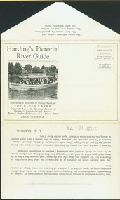
Postcard, Melbourne Ferries Pty Ltd, Harding's Pictorial River Guide
... Selection of ‘beauty spots’ along Yarra between Princes Bridge and Heidelberg via Studley Park. Boat advertises Harding’s Launches Studley Park & Heidelberg. ...Selection of ‘beauty spots’ along Yarra between Princes Bridge and Heidelberg via Studley Park. Boat advertises Harding’s Launches Studley Park & Heidelberg. ...One of a number of 'real photo' and commercial postcards created by or owned by members of the Christian and Washfold families of Kew. The postcards are part of a larger collection of photographs, postcards and publications donated to the collection in May 2021.Postcard folder. Selection of ‘beauty spots’ along Yarra between Princes Bridge and Heidelberg via Studley Park. Boat advertises Harding’s Launches Studley Park & Heidelberg. Pictured boat is ‘25 Canberra’.harding's river cruises, river yarra -- tourism, harding's boat cruises, christian-washfold collection -
 Kew Historical Society Inc
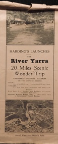
Flyer, Melbourne Ferries Pty Ltd, River Yarra: 20 Miles Scenic Wonder Trip
... The tourist trip passed a number of ‘beauty spots’ along the river between Princes Bridge and Heidelberg via Studley Park. Hardings ran a number of boats including the Canberra and Mississippi....The tourist trip passed a number of ‘beauty spots’ along the river between Princes Bridge and Heidelberg via Studley Park. Hardings ran a number of boats including the Canberra and Mississippi. river yarra melbourne ferries pty ltd yarra river -- tourism harding's cruises christian-washfold collection Bifold brochure including route map of the full 44 mile 'Wonder Trip' on pages 2 & 3. ...Bifold brochure including route map of the full 44 mile 'Wonder Trip' on pages 2 & 3. Photos used include an 'Aerial view over Dight's Falls', two ferries, and a 'Scene near Dight's Falls'.Flyer for Harding’s Launches on the River Yarra: 20 miles scenic wonder trip. Aerial view over Dight’s Falls on front. non-fictionBifold brochure including route map of the full 44 mile 'Wonder Trip' on pages 2 & 3. Photos used include an 'Aerial view over Dight's Falls', two ferries, and a 'Scene near Dight's Falls'.river yarra, melbourne ferries pty ltd, yarra river -- tourism, harding's cruises, christian-washfold collection -
 Kew Historical Society Inc
Album - Photograph Album No.1, Henry Beater Christian, 1924-26
... bridge...kew (vic.) — macauley’s boathouse...studley park....) — zig-zag bridge kew (vic.) — macauley’s boathouse studley park (vic.) — yarra river wonderland — grampians (vic.) black spur (vic.) marysville (vic.) maroondah dam (vic.) — construction warburton (vic.) cockatoo (vic.) bruthen (vic.) swan reach road (vic.) glen hills (vic.) lightning creek (vic.) omeo (vic.) glen wills (vic.) mt wills (vic.) sunnyside (vic) granite flat (vic.) toolangi (vic.) yea (vic ). flowerdale (vic.) mt white law (vic.) baw baw (vic.) christian-washfold collection Digital copy of a 47-page photograph album containing 255 gelatinous silver images, loaned by Diane Washfold with permission given to digitise and hold a copy in our collection. ...Henry Christian (c.1809-91), the grandfather of the photographer, was one of the first settlers in Kew. He arrived in Victoria with his wife Agnes and son Orlando in 1855 on the Gypsy Queen. He established a rope-making business in Bulleen Road by 1858 but was declared insolvent two years later. In his final years, he was celebrated as one of the oldest living settlers of the district. His son, Orlando Henry Beater Christian (c.1853-1930) became a member of the Hawthorn Band and a foundation member of the Willsmere Swimming Club. Orlando and his wife Elizabeth had four children of which Henry Beater Christian (1886-1962) was the oldest.An album of photographs, compiled by Henry Beater Christian (1886-1962) of Pakington Street, Kew, depicting individuals, natural and settled environments and the interactions between these worlds. Henry Christian, was a keen explorer, not just of his immediate environment but also of the Victorian wilderness. His major opus is contained in two albums in which he records, sometimes in majestic detail and on other occasions the intimate features of the natural world. His photographic travels during the 1920s, often in solitary ramblings but on other occasions with companions, recall the heroic landscape photography of an earlier era, pioneered by Nicholas Caire. In addition to their aesthetic value, the albums are historically significant records within the State of Victoria, of what is now a distant point in time, and of places that have become radically altered through human intervention.Digital copy of a 47-page photograph album containing 255 gelatinous silver images, loaned by Diane Washfold with permission given to digitise and hold a copy in our collection. The album contains a groups of photographic positives taken by Henry B Christian (a resident of Pakington Street), of places in Kew and throughout regional Victoria during the 1920s. The mainly sepia photographs, while small, are of a high quality. Photographs are typically lightly glued onto pages. Locations are frequently identified by white or black ink, which in a number of cases is illegible due to wear. Readable named locations include: Kew, the Grampians, Marysville, Baw Baw, Daylesford, Hepburn Springs, Bruthen, Swan Reach, Yea, Flowerdale, Port Fairy, Cockatoo, etc.henry beater christian (1886-1962), landscape photography, photograph albums, kew (vic.) — yarra river, kew (vic.) — zig-zag bridge, kew (vic.) — macauley’s boathouse, studley park (vic.) — yarra river, wonderland — grampians (vic.), black spur (vic.), marysville (vic.), maroondah dam (vic.) — construction, warburton (vic.), cockatoo (vic.), bruthen (vic.), swan reach road (vic.), glen hills (vic.), lightning creek (vic.), omeo (vic.), glen wills (vic.), mt wills (vic.), sunnyside (vic), granite flat (vic.), toolangi (vic.), yea (vic, )., flowerdale (vic.), mt white law (vic.), baw baw (vic.), christian-washfold collection