
Showing 196 items matching "studley street"
-
 Sunshine and District Historical Society Incorporated
Administrative record - City of Sunshine - Commissioner Mr Alexander Alex George Gillon Collection 1976 - 1982 - Minutes of Special Meeting 3rd November 1976, City of Sunshine, 3rd November 1976
... ...Studley Street...John's College School Churchill Avenue Land Use Permit McDonald Properties 396 Ballarat Road Land Use Permit Application Factory / Warehouse Lots 258, 259, 260 & 261 Rothray Avenue Club Rooms for Sunshine United Cricket Club Rooms Extension Garage Over Easement 4 Gail Street Land Use Permit Application Industrial Sales Oliver-Davey Glass Lot 1 Tottenham Parade S/F Garage 60 Ballarat Road Maidstone Undersize Allotment 10 Studley Street Maidstone Orders of the Day Proposal to Discontinue Roads off Alexandra Avenue and Service Street Sunshine...John's College McDonalds Rothray Avenue Sunshine United Cricket Club Selwyn Park Selwyn Street Gail Street Tottenham Parade Footscray West Durham Road Studley Street Maidstone Alexandra Avenue Service Street Ainsworth Reserve Day Care Centre Vernon Street Rosamond Bowling Club Rosamond Tennis Club Rosamond Road Maribyrnong Minutes of special meeting 3rd November 1976 Report of the Town Clerk Proposed Lease of Land from Railways near H.V. ...Minutes of special meeting 3rd November 1976 Report of the Town Clerk Proposed Lease of Land from Railways near H.V. McKay Memorial Gardens for proposed car park Land transfer to Mental Health Authority Proposed St. Albans Sport Club Proposed Newport Power Station Street Construction Agreement Stage 5 Nickson's Subdivision Proposed Purchase of Land Main Road West & Camelot Drive M.M.B.W. Representation Report of By-Laws Officer Fire Hazard Tender for Removal of Fire Hazards Seasons 1976/1977 Snake Eradication Report of City Engineer Contract Annual Supply of Concrete Annual Supplies Third Party Conference of Municipal Engineers Neale Road Estate Stage 1 Western Gate Estate Stage 1A Strata Subdivision 1 Clacton Street Consolidation of Title Lots 1 & 120 McIntyre Road Condition of St. Albans Road Vinidex Tubemakers Pty Ltd Availability of Sewerage in part of Sheffield Estate Plan of Subdivision Neale Road and Oakwood Road Plan of Subdivision Ballarat Road Albion Reid Pty Ltd Damaged to Footpath Westmoreland Road Hospital Land Plan of Subdivision 74 - 78 Hampshire Road Report of Chief Planner Building Over Easement Policy Cash In Lieu Of Carking Parking Brick Garage Lot 34 Station Road St. Albans Land Use Application Subdivision Neale Road Land Use Application Signs Ballarat Road Land Use Application Subdivision Furlong Road Land Use Application Additions to Parish Centre / School Oleander Drive Land Use Application Shops and Associated Car Parking Princes Street Land Use Permit Application for Extension of Time Lots 169 & 1970 Billingham Road Land Use Permit Service Premises and Dwelling Ralph Street Bus Parking Bays Glengala Road Land Use Permit Application Signs Lots 178. 179 & 180 Cedra Close Land Use Permit Application Factory Lots 8 & 10 Cromer Avenue Land Use Permit Application Additions to St. John's College School Churchill Avenue Land Use Permit McDonald Properties 396 Ballarat Road Land Use Permit Application Factory / Warehouse Lots 258, 259, 260 & 261 Rothray Avenue Club Rooms for Sunshine United Cricket Club Rooms Extension Garage Over Easement 4 Gail Street Land Use Permit Application Industrial Sales Oliver-Davey Glass Lot 1 Tottenham Parade S/F Garage 60 Ballarat Road Maidstone Undersize Allotment 10 Studley Street Maidstone Orders of the Day Proposal to Discontinue Roads off Alexandra Avenue and Service Street Sunshine city of sunshine, alexander "alex" george gillon, st. albans sports club, h.v. mckay memorial gardens, anderson road, sunshine, newport power substation, main road west, camelot drive, st. albans, clacton street, mcintyre road, sunshine north, st. albans road, vinidex tubemakers, neale road, oakwood road, deer park, albion reid, ballarat road, westmoreland road, hampshire road, station road, furlong road, oleander drive, princes street, ralph street, sunshine west, cedar close, cromer avenue, churchill avenue, braybrook, st. john's college, mcdonalds, rothray avenue, sunshine united cricket club, selwyn park, selwyn street, gail street, tottenham parade, footscray west, durham road, studley street, maidstone, alexandra avenue, service street, ainsworth reserve day care centre, vernon street, rosamond bowling club, rosamond tennis club, rosamond road, maribyrnong -
 Sunshine and District Historical Society Incorporated
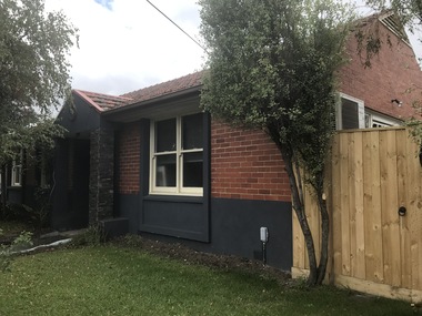
Photograph - Maidstone 2021 Photographs Part 3, John Alchin, 2021
... ...Studley Street...Short Street Studley Street Thomson Street Yardley Street Hampstead Road Williamson Road Maidstone Maidstone Police Station Salvation Army Church Albert Facey Maidstone Tennis Club Maidstone Community Centre Midway Migrant Hostel Philip Migrant Hostel Student Village 5594.01 - Short St 8 Maidstone - Former Police Station 2021 Photo 01.JPG 5594.02 - Short St 8 Maidstone - Former Police Station 2021 Photo 02.JPG 5594.03 - Short St 8 Maidstone - Former Police Station 2021 Photo 04.JPG 5594.04 - Studley St 24 Maidstone - Former Shop 2021 Photo 01.JPG 5594.05 - Studley St 34 - 36 Maidstone - Former Salvation Army Church 2021 Photo 03.JPG 5594.06 - Thomson St 28 Maidstone - Former Shop Site 2021 Photo 01.JPG 5594.07 - Thomson St Maidstone - Maidstone Tennis Club 2021 Photo 01.JPG 5594.08 - Thomson St Maidstone - Maidstone Tennis Club 2021 Photo 02.JPG 5594.09 - Thomson St Outside 7 Maidstone - Albert Facey Information Board Photo 01.JPG 5594.10 - Yardley St 21 Maidstone - Maidstone Community Centre 2021 Photo 03.JPG 5594.11 - Hampstead Rd - Midway Migrant Hostel Hampstead Rd 2021 Photo 01.JPG 5594.12 - Hampstead Rd - Midway Migrant Hostel 2021 Photo 03.JPG 5594.13 - Williamson Road Rd - Midway Migrant Hostel 2021 Photo 05.JPG 5594.14 - Williamson Rd - Midway Migrant Hostel 2021 Photo 09.JPG 5594.15 - Williamson Rd - Midway Migrant Hostel 2021 Photo 12.JPG 5594.16 - Williamson Rd - Midway Migrant Hostel 2021 Photo 14.JPG 5594.17 - Williamson Rd - Midway Migrant Hostel 2021 Photo 10.JPG 5594.18 - Williamson Rd - Midway Migrant Hostel 2021 Photo 01.JPG 5594.19 - Williamson Rd - Midway Migrant Hostel 2021 Photo 15.JPG 5594.20 - Williamson Rd - Midway Migrant Hostel 2021 Photo 16.JPG 5594.21 - Williamson Rd - Midway Migrant Hostel 2021 Photo 17.JPG 5594.22 - Williamson Rd - Philip Migrant Hostel 2021 Photo 01.JPG 5594.23 - Williamson Rd - Philip Migrant Hostel 2021 Photo 04.JPG This is a large collection of photographs which has been split over three identification numbers. ...Maidstone was originally part of the former Shire of Braybrook and later the City of Sunshine. However, in 1994, Victoria underwent council amalgamations, which resulted in Braybrook being incorporated into the City of Maribyrnong. The suburb of Maidstone continues to attract considerable attention from the residents of City of Brimbank, particularly its historical features, the old buildings and distinctive streetscapes that characterise the area.To capture the essence of Maidstone in 2021, a series of photographs were taken. These images document a range of buildings, street scenes, and other notable points of interest throughout the suburb, providing a visual record of its unique character.5594.01 - Short St 8 Maidstone - Former Police Station 2021 Photo 01.JPG 5594.02 - Short St 8 Maidstone - Former Police Station 2021 Photo 02.JPG 5594.03 - Short St 8 Maidstone - Former Police Station 2021 Photo 04.JPG 5594.04 - Studley St 24 Maidstone - Former Shop 2021 Photo 01.JPG 5594.05 - Studley St 34 - 36 Maidstone - Former Salvation Army Church 2021 Photo 03.JPG 5594.06 - Thomson St 28 Maidstone - Former Shop Site 2021 Photo 01.JPG 5594.07 - Thomson St Maidstone - Maidstone Tennis Club 2021 Photo 01.JPG 5594.08 - Thomson St Maidstone - Maidstone Tennis Club 2021 Photo 02.JPG 5594.09 - Thomson St Outside 7 Maidstone - Albert Facey Information Board Photo 01.JPG 5594.10 - Yardley St 21 Maidstone - Maidstone Community Centre 2021 Photo 03.JPG 5594.11 - Hampstead Rd - Midway Migrant Hostel Hampstead Rd 2021 Photo 01.JPG 5594.12 - Hampstead Rd - Midway Migrant Hostel 2021 Photo 03.JPG 5594.13 - Williamson Road Rd - Midway Migrant Hostel 2021 Photo 05.JPG 5594.14 - Williamson Rd - Midway Migrant Hostel 2021 Photo 09.JPG 5594.15 - Williamson Rd - Midway Migrant Hostel 2021 Photo 12.JPG 5594.16 - Williamson Rd - Midway Migrant Hostel 2021 Photo 14.JPG 5594.17 - Williamson Rd - Midway Migrant Hostel 2021 Photo 10.JPG 5594.18 - Williamson Rd - Midway Migrant Hostel 2021 Photo 01.JPG 5594.19 - Williamson Rd - Midway Migrant Hostel 2021 Photo 15.JPG 5594.20 - Williamson Rd - Midway Migrant Hostel 2021 Photo 16.JPG 5594.21 - Williamson Rd - Midway Migrant Hostel 2021 Photo 17.JPG 5594.22 - Williamson Rd - Philip Migrant Hostel 2021 Photo 01.JPG 5594.23 - Williamson Rd - Philip Migrant Hostel 2021 Photo 04.JPG short street, studley street, thomson street, yardley street, hampstead road, williamson road, maidstone, maidstone police station, salvation army church, albert facey, maidstone tennis club, maidstone community centre, midway migrant hostel, philip migrant hostel, student village -
 Sunshine and District Historical Society Incorporated
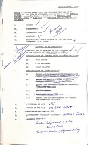
Administrative record - City of Sunshine - Commissioner Mr Alexander Alex George Gillon Collection 1976 - 1982 - Notice of Ordinary Meeting 19th October 1976, City of Sunshine, 19th October 1976
... ...Studley Street...John's College School Churchill Avenue Land Use Permit McDonald Properties 396 Ballarat Road Land Use Permit Application Factory / Warehouse Lots 258, 259, 260 & 261 Rothray Avenue Club Rooms for Sunshine United Cricket Club Rooms Extension Garage Over Easement 4 Gail Street Land Use Permit Application Industrial Sales Oliver-Davey Glass Lot 1 Tottenham Parade S/F Garage 60 Ballarat Road Maidstone Undersize Allotment 10 Studley Street Maidstone Orders of the Day Proposal to Discontinue Roads off Alexandra Avenue and Service Street Sunshine...John's College Rothway Avenue Sunshine United Cricket Club Selwyn Park Selwyn Street Gail Street Tottenham Parade Footscray West Studley Street Maidstone Service Street Alexander Avenue Albion Tip Sunshine Tip Notice of Ordinary Meeting 19th October 1976 Report of Town Clerk Proposed Lease of Land from Railways near H.V. ...Notice of Ordinary Meeting 19th October 1976 Report of Town Clerk Proposed Lease of Land from Railways near H.V. McKay Memorial Gardens for proposed car park Land transfer to Mental Health Authority Proposed St. Albans Sport Club Proposed Newport Power Station Street Construction Agreement Stage 5 Nickson's Subdivision Proposed Purchase of Land Main Road West and Camelot Drive M.M.B.W. Representation Report of By-Laws Officer Fire Hazards Removal of Fire Hazards 1976/1977 Snake Eradication Report of City Engineer Contract Annual Supply of Concrete Annual Supplies Third Party Conference of Municipal Engineers Report on Contract Glengala Estate State 3 Private Street Scheme Report on Contract Garfield Street Private Street Scheme Report on Contract Dalton Street Private Street Scheme Report on Contract Fourth Avenue Private Street Scheme Private Subdivision Furlong Road Estate Stage 7 Private Subdivision Furlong Road Stage 6 Private Subdivision Furlong Road Stage 5 Private Subdivision Furlong Road Stage 3 & 4 Private Subdivision Furlong Road Stages 1 & 2 Private Subdivision Western Gate Stage 1B Private Subdivision Western Gate Stage 2 Private Subdivision Western Gate Stages 3a & 3B Private Subdivision Shopping Centre Car Park Corner Tallintyre Road and Fairbairn Road and Fairbairn Road Rappaport Housing Commission Private Subdivision Albanvale Stage 17 Private Subdivision Western Gate Stage 1A Private Subdivision Private Street Scheme Navigator Street McIntyre Road Outfall Drain Stage 2 McIntyre Road Construction South Road Drain Paw Paw Road Berkshire Road Drain Burgess Road Construction Grading Cranwell Street, Main Road East & McIntyre Road Cornhill Reserve Drain Evans Street Drain Market Road Drain Station Road Drains Wright Street Traffic Island Cooper Street Flats Rosamond Road Traffic Lights Soil Parks and Recreation Construction Strata Subdivision 1 Clacton Street Consolidation of Title Lots 1 & 120 McIntyre Road Condition of St. Albans Road Vinidex Tubemakers Pty Ltd Consolidation of Title Lots 1 & 2 Tallintyre Road and Fairbairn Road Availability of Sewerage in part of Sheffield Estate Plan of Subdivision Neale Road and Oakwood Road Plan of Subdivision Ballarat Road Albion Reid Pty Ltd Damaged to Footpath Westmoreland Road Hospital Land Plan of Subdivision 74 - 78 Hampshire Road Report of Chief Planner Building Over Easement Policy Cash In Lieu Of Carking Parking Brick Garage Lot 34 Station Road St. Albans Land Use Application Subdivision Neale Road Land Use Application Signs Ballarat Road Land Use Application Subdivision Furlong Road Land Use Application Additions to Parish Centre / School Oleander Drive Land Use Application Shops and Associated Car Parking Princes Street Land Use Permit Application for Extension of Time Lots 169 & 1970 Billingham Road Land Use Permit Service Premises and Dwelling Ralph Street Bus Parking Bays Glengala Road Land Use Permit Application Signs Lots 178. 179 & 180 Cedra Close Land Use Permit Application Factory Lots 8 & 10 Cromer Avenue Land Use Permit Application Additions to St. John's College School Churchill Avenue Land Use Permit McDonald Properties 396 Ballarat Road Land Use Permit Application Factory / Warehouse Lots 258, 259, 260 & 261 Rothray Avenue Club Rooms for Sunshine United Cricket Club Rooms Extension Garage Over Easement 4 Gail Street Land Use Permit Application Industrial Sales Oliver-Davey Glass Lot 1 Tottenham Parade S/F Garage 60 Ballarat Road Maidstone Undersize Allotment 10 Studley Street Maidstone Orders of the Day Proposal to Discontinue Roads off Alexandra Avenue and Service Street Sunshine city of sunshine, alexander "alex" george gillon, st. albans sport club, h.v. mckay memorial gardens, newport power substation, main road west, camelot street, st. albans, sunshine, kings park reserve, gillespie road, fourth avenue, garfield street, tallintyre road, fairbairn road, sunshine west, neale road, deer park, navigator street, maribyrnong, mcintyre road, sunshine north, south road, braybrook, paw paw road brooklyn, berkshire road, burgess street, brooklyn, cornhill reserve, cornhill street, cranwell street, main road east, evans street, market road, station road, hargreaves cresent, mclennan street, thompson street, millbank drive, wright street, cooper street, rosamond road, raleigh road, clacton street, st. albans road, vinidex tubemakers, oakwood road, albion reid, hampshire road, station street, ballarat road, albion, furlong road, oleander drive, princes street, ralph street, glengala road, cedar close, cromer street, churchill avenue, st. john's college, rothway avenue, sunshine united cricket club, selwyn park, selwyn street, gail street, tottenham parade, footscray west, studley street, maidstone, service street, alexander avenue, albion tip, sunshine tip -
 Sunshine and District Historical Society Incorporated
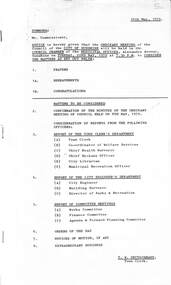
Administrative record - City of Sunshine - Commissioner Mr Alexander Alex George Gillon Collection 1976 - 1982 - Notice of ordinary meeting of the council 22nd May 1979, City of Sunshine, 16th May 1979
... ...Studley Street...Albans Relocation of Public Telephone Outside 38A Melton Street to between 26 & 28 Melon Street Braybrook Sewerage Facilities Declaration of Sewerage Area No 3760 Noxious Trades Outfall Sewer Replacement Lacy Street, Ballarat Road & Ashley Street, Braybrook and Thomson Street, Burns Street & Studley Street Maidstone Sewerage Facilities Council Reserve Larisa Road St. ...Albans Relocation of Public Telephone Outside 38A Melton Street to between 26 & 28 Melon Street Braybrook Sewerage Facilities Declaration of Sewerage Area No 3760 Noxious Trades Outfall Sewer Replacement Lacy Street, Ballarat Road & Ashley Street, Braybrook and Thomson Street, Burns Street & Studley Street Maidstone Sewerage Facilities Council Reserve Larisa Road St. ...Notice of Ordinary Meeting of the Council 22nd May 1979 Report of the Town Clerk's Department Report of the Town Clerk Interim Report The Role of Local Government in Victoria Activities of the Municipal Association of Victoria Propose Lease Extension Tottenham Technical School 27 Duke Street Rate Recovery Sale 2nd December 1979 Land Transfer Fairbairn Road Widening Proposed Purchase of Land Station Road for Multi-Functional Building Local Authorities Superannuation Scheme Report of the Co-Ordinator of Welfare Services Teenage Holiday Programme Australian National Youth Workers' Conference Freemantle Western Australia 18th to 24th July 1979 Family and Community Service Program Election to Committee Concessions for Telephone Installation and Rental for Pensioners Residential Tenancies Bill Braybrook Pre-School Child Care Facility Cherry Crescent Braybrook Early Childhood Development Programme Braybrook Maidstone Housing Commission Liaison Committee Report of the Chief Health Surveyor Health Act registrations for 1979 Application for Transfer of Proprietorship of Premises under the Health Act J.L. MacTaggart (Victoria) Pty Ltd Maria Street Laverton North Town and Country Planning and Health Act Objections Offensive Trades Report of the Chief By-Laws Officer Proposed No Standing Area Majorca Street St. Albans Proposed No Standing Area Martin Street Sunshine Report of the City Librarian Australian Olympic Team Fund Report of the City Engineer & Planner Planning Permit Community Health Centre Andrea Street St. Albans Planning Permit Application Temporary Child Care Centre Andrea Street St. Albans Planning Permit Application Sky Sign Lot 8 Churchill Avenue Braybrook Planning Permit Application Service Premises & Caretaker's Dwelling Lots 317 & 318 Dover Street Albanvale Planning Permit Three Factories Lot 67 Somerville Road South West Corner of McDonald Road Brooklyn Planning Permit Application Hairdressing Salon Service Premise and Caretaker's Dwelling Lot 1 Ballarat Road Planning Permit Application Travel Agency Shop 1A Lot 3 Princess Street St. Albans Planning Permit Application Small Panel Sign Lot 4 McIntyre Road Sunshine North Planning Permit Application Display Homes Lots 1, 2, 3, 4, 5 & 6 Camelot Drive South East Corner Main Road West Albanvale Planning Permit Application Alterations to Shops Lots 1 & 2 Ballarat Road Deer Park Planning Permit Application Motor Workshop Lot 1 McIntyre Road Sunshine North Planning Permit Application Medical Consulting Room and Residence Lot 1 Ballarat Road South West Corner of Burnside Street Deer Park Planning Permit Application New Offices and Showrooms Railway Lot 24 North West Corner of Berkshire Road and Steers Street Sunshine North Strata Subdivision 5 & 7 Craddock Court Sunshine North Plan of Subdivision Westerngate Estate Subdivision Westerngate Estate Stage 1A Subdivision Consolidation of Title 811 - 811A Ballarat Road Deer Park Cancellation of Easement St. Albans Road Abutting Gilmour Road Sunshine North Strata Subdivision 101 Ballarat Road Maidstone Strata Subdivision 1 & 3 Craddock Court Sunshine North Replacement of Ford Falcon Utilities and Station Wagons Boring Operations by Melbourne & Metropolitan Board of Works Station Road, Gladstone Street & Washington Street St. Albans Relocation of Public Telephone Outside 38A Melton Street to between 26 & 28 Melon Street Braybrook Sewerage Facilities Declaration of Sewerage Area No 3760 Noxious Trades Outfall Sewer Replacement Lacy Street, Ballarat Road & Ashley Street, Braybrook and Thomson Street, Burns Street & Studley Street Maidstone Sewerage Facilities Council Reserve Larisa Road St. Albans Infant Welfare Centre Alexandra Avenue Sunshine Castley Hall in Poor Condition Exterior Security Lighting Central Library and Infant Welfare Centre Report of the Building Surveyor Building Over Easement 144 Murray Street Ardeer Building Over Easement 4 Tania Street Sunshine North Building Over Easement Lots 77, 78 & 79 Somers Street Sunshine North Siting of Building 39 Dunbar Avenue Sunshine Siting of Building 4 Norma Street Sunshine Building on Flood Prone Land 27 Navigator Street Maribyrnong Building on Flood Prone Land Lot 18 Riverview Court Maribyrnong Installation of Underground Tanks 3 Millers Road Brooklyn Installation of Underground Tanks Corner Ballarat Road and Lacy Street Braybrook Uniform Building Regulations Enforcement Staff Needs Report of the Director of Parks & Recreations Winslow Crescent Application to Use Land Bon Thomas Child Care Centre Landscaping Quotes Orders of the Day Accounts Submitted for Payment as at 30th April 1979 Uniform Building Regulations Enforcement Staff Needs Confirmation of Loan with the Melbourne & Metropolitan Board of Workstottenham technical school, duke street, sunshine, station road, deer park, south road, braybrook, braybrook pre-school childcare centre, cherry crescent, braybrook maidstone housing commission liaison committee, j.l. mactaggart, maria street, laverton north, majorca street, st. albans, martin street, andrea street, andrea street community health care centre, churchill avenue, dover street, albanvale, somerville road, mcdonald road, brooklyn, ballarat road, princess street, mcintyre road, sunshine north, camelot drive, main road west, burnside street, berkshire road, steers street, craddock court, maidstone, gladstone street, washington street, melton street, lacy street, ashley street, thomson street, burns street, studley street, larisa reserve, larisa road, alexandra avenue infant welfare centre, alexandra avenue, castley hall, simmie street, sunshine west, murray street, ardeer, tania street, somers street, dunbar avenue, norma street, navigator street, riverview court, maribyrnong, millers road, bon thomas child care centre, quinn street -
 Sunshine and District Historical Society Incorporated
Administrative record - City of Sunshine - Commissioner Mr Alexander Alex George Gillon Collection 1976 - 1982 - Minutes of the ordinary meeting of council held on 22nd May 1979, City of Sunshine, 22nd May 1979
... ...Studley Street...Albans Relocation of Public Telephone Outside 38A Melton Street to between 26 & 28 Melon Street Braybrook Sewerage Facilities Declaration of Sewerage Area No 3760 Noxious Trades Outfall Sewer Replacement Lacy Street, Ballarat Road & Ashley Street, Braybrook and Thomson Street, Burns Street & Studley Street Maidstone Sewerage Facilities Council Reserve Larisa Road St. ...Albans Relocation of Public Telephone Outside 38A Melton Street to between 26 & 28 Melon Street Braybrook Sewerage Facilities Declaration of Sewerage Area No 3760 Noxious Trades Outfall Sewer Replacement Lacy Street, Ballarat Road & Ashley Street, Braybrook and Thomson Street, Burns Street & Studley Street Maidstone Sewerage Facilities Council Reserve Larisa Road St. ...Minutes of the Ordinary Meeting of Council held on 22nd May 1979 Report of the Town Clerk's Department Report of the Town Clerk Interim Report The Role of Local Government in Victoria Activities of the Municipal Association of Victoria Propose Lease Extension Tottenham Technical School 27 Duke Street Rate Recovery Sale 2nd December 1979 Land Transfer Fairbairn Road Widening Proposed Purchase of Land Station Road for Multi-Functional Building Local Authorities Superannuation Scheme Report of the Co-Ordinator of Welfare Services Teenage Holiday Programme Australian National Youth Workers' Conference Freemantle Western Australia 18th to 24th July 1979 Family and Community Service Program Election to Committee Concessions for Telephone Installation and Rental for Pensioners Residential Tenancies Bill Braybrook Pre-School Child Care Facility Cherry Crescent Braybrook Early Childhood Development Programme Braybrook Maidstone Housing Commission Liaison Committee Report of the Chief Health Surveyor Health Act registrations for 1979 Application for Transfer of Proprietorship of Premises under the Health Act J.L. MacTaggart (Victoria) Pty Ltd Maria Street Laverton North Town and Country Planning and Health Act Objections Offensive Trades Report of the Chief By-Laws Officer Proposed No Standing Area Majorca Street St. Albans Proposed No Standing Area Martin Street Sunshine Report of the City Librarian Australian Olympic Team Fund Report of the City Engineer & Planner Planning Permit Community Health Centre Andrea Street St. Albans Planning Permit Application Temporary Child Care Centre Andrea Street St. Albans Planning Permit Application Sky Sign Lot 8 Churchill Avenue Braybrook Planning Permit Application Service Premises & Caretaker's Dwelling Lots 317 & 318 Dover Street Albanvale Planning Permit Three Factories Lot 67 Somerville Road South West Corner of McDonald Road Brooklyn Planning Permit Application Hairdressing Salon Service Premise and Caretaker's Dwelling Lot 1 Ballarat Road Planning Permit Application Travel Agency Shop 1A Lot 3 Princess Street St. Albans Planning Permit Application Small Panel Sign Lot 4 McIntyre Road Sunshine North Planning Permit Application Display Homes Lots 1, 2, 3, 4, 5 & 6 Camelot Drive South East Corner Main Road West Albanvale Planning Permit Application Alterations to Shops Lots 1 & 2 Ballarat Road Deer Park Planning Permit Application Motor Workshop Lot 1 McIntyre Road Sunshine North Planning Permit Application Medical Consulting Room and Residence Lot 1 Ballarat Road South West Corner of Burnside Street Deer Park Planning Permit Application New Offices and Showrooms Railway Lot 24 North West Corner of Berkshire Road and Steers Street Sunshine North Strata Subdivision 5 & 7 Craddock Court Sunshine North Plan of Subdivision Westerngate Estate Subdivision Westerngate Estate Stage 1A Subdivision Consolidation of Title 811 - 811A Ballarat Road Deer Park Cancellation of Easement St. Albans Road Abutting Gilmour Road Sunshine North Strata Subdivision 101 Ballarat Road Maidstone Strata Subdivision 1 & 3 Craddock Court Sunshine North Replacement of Ford Falcon Utilities and Station Wagons Boring Operations by Melbourne & Metropolitan Board of Works Station Road, Gladstone Street & Washington Street St. Albans Relocation of Public Telephone Outside 38A Melton Street to between 26 & 28 Melon Street Braybrook Sewerage Facilities Declaration of Sewerage Area No 3760 Noxious Trades Outfall Sewer Replacement Lacy Street, Ballarat Road & Ashley Street, Braybrook and Thomson Street, Burns Street & Studley Street Maidstone Sewerage Facilities Council Reserve Larisa Road St. Albans Infant Welfare Centre Alexandra Avenue Sunshine Castley Hall in Poor Condition Exterior Security Lighting Central Library and Infant Welfare Centre Report of the Building Surveyor Building Over Easement 144 Murray Street Ardeer Building Over Easement 4 Tania Street Sunshine North Building Over Easement Lots 77, 78 & 79 Somers Street Sunshine North Siting of Building 39 Dunbar Avenue Sunshine Siting of Building 4 Norma Street Sunshine Building on Flood Prone Land 27 Navigator Street Maribyrnong Building on Flood Prone Land Lot 18 Riverview Court Maribyrnong Installation of Underground Tanks 3 Millers Road Brooklyn Installation of Underground Tanks Corner Ballarat Road and Lacy Street Braybrook Uniform Building Regulations Enforcement Staff Needs Report of the Director of Parks & Recreations Winslow Crescent Application to Use Land Bon Thomas Child Care Centre Landscaping Quotes Orders of the Day Accounts Submitted for Payment as at 30th April 1979 Uniform Building Regulations Enforcement Staff Needs Confirmation of Loan with the Melbourne & Metropolitan Board of Works Extraordinary Business Report of the Town Clerk Election of Council Representative Metropolitan Fire Brigade's Boardtottenham technical school, duke street, sunshine, station road, deer park, south road, braybrook, braybrook pre-school child care facility, cherry crescent, j.l. mactaggart, maria street, laverton north, majorca street, st. albans, martin street, andrea street community health care centre, andrea street, churchill avenue, dover street, albanvale, somerville road, mcdonald road, brooklyn, princess street, mcintyre road, sunshine north, camelot drive, main road west, ballarat road, burnside street, berkshire road, steers street, craddock court, st. albans road, gilmour road, maidstone, gladstone street, washington street, melton street, lacy street, ashley street, thomson street, burns street, studley street, laris reserve, larisa road, alexandra avenue infant welfare centre, alexandra avenue, castley hall, simmie street, sunshine west, murray street, ardeer, tania street, somers street, dunbar avenue, norma street, navigator street, riverview court, maribyrnong, millers road, bon thomas child care centre, quinn street -
 Kew Historical Society Inc
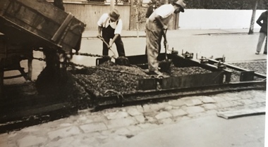
Photograph - Street Works, Studley Park Road, March 1934
... Street Works, Studley Park Road...street works -- kew (vic.)...public works kew (vic.)...studley...Studley Park Road, like most streets in Kew, was originally a dirt road. ...Photograph Street Works, Studley Park Road ...Studley Park Road, like most streets in Kew, was originally a dirt road. Street works during the Great Depression included bituminising major roads in the district. This photograph of Council works originated in the City of Kew Engineers Department as a record of works undertaken. It was given to the collection by a Mrs Fisher in 1998.Well provenanced photograph of Council-funded public works in Kew during the Great Depression. Original sepia monochrome positive of Council workers spreading bitumen in Studley Park Road, Kew.Typed reverse: "B4 / Kew C.C. / Spreading premixed material on Studley Park Road with drag spreader, March 1934"roadworks -- kew (vic.), street works -- kew (vic.), public works kew (vic.), studley park road -- kew (vic.), city of kew -- engineers department, city of kew -- public works -- great depression -- 1930s -
 Kew Historical Society Inc
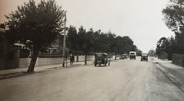
Photograph - Street Works, Studley Park Road, March 1934
... Street Works, Studley Park Road...street works -- kew (vic.)...public works kew (vic.)...studley...Studley Park Road, like most streets in Kew, was originally a dirt road. ...Photograph Street Works, Studley Park Road ...Studley Park Road, like most streets in Kew, was originally a dirt road. Street works during the Great Depression included bituminising major roads in the district. This photograph of Council works originated in the City of Kew Engineers Department as a record of works undertaken. It was given to the collection by a Mrs Fisher in 1998.Well provenanced photograph of Council-funded public works in Kew during the Great Depression. Original sepia monochrome positive of Studley Park Road, Kew.Typed reverse: "B4 / Kew C.C. / Studley Park Road after surfacing with one coat of premixed material spread with drag, March 1934"roadworks -- kew (vic.), street works -- kew (vic.), public works kew (vic.), studley park road -- kew (vic.), city of kew -- engineers department, city of kew -- public works -- great depression -- 1930s -
 Kew Historical Society Inc
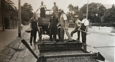
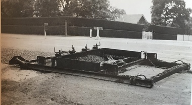
Photograph - Street Works, Studley Park Road, March 1934
... Street Works, Studley Park Road...street works -- kew (vic.)...public works kew (vic.)...studley...Studley Park Road, like most streets in Kew, was originally a dirt road. ...Original sepia monochrome positive of Council workers standing on and beside a dray in Studley Park Road, Kew while resurfacing of the street was taking place. ...Photograph Street Works, Studley Park Road ...Studley Park Road, like most streets in Kew, was originally a dirt road. Street works during the Great Depression included bituminising major roads in the district. This photograph of Council works originated in the City of Kew Engineers Department as a record of works undertaken. It was given to the collection by a Mrs Fisher in 1998.Well provenanced photograph of Council-funded public works in Kew during the Great Depression. Original sepia monochrome positive of Council workers standing on and beside a dray in Studley Park Road, Kew while resurfacing of the street was taking place. The Kew Junction is just visible behind the men.Typed reverse: "B4 / Kew C.C. / Spreading premixed material on Studley Park Road with drag spreader, view from rear of machine, March 1934"roadworks -- kew (vic.), street works -- kew (vic.), public works kew (vic.), studley park road -- kew (vic.), city of kew -- engineers department, city of kew -- public works -- great depression -- 1930s -
 Kew Historical Society Inc
Photograph - Street Works, Studley Park Road, March 1934
... Street Works, Studley Park Road...street works -- kew (vic.)...public works kew (vic.)...studley...Studley Park Road, like most streets in Kew, was originally a dirt road. ...Photograph Street Works, Studley Park Road ...Studley Park Road, like most streets in Kew, was originally a dirt road. Street works during the Great Depression included bituminising major roads in the district. This photograph of Council works originated in the City of Kew Engineers Department as a record of works undertaken. It was given to the collection by a Mrs Fisher in 1998.Well provenanced photograph of Council-funded public works in Kew during the Great Depression. Original sepia photographic positive of a drag used to spread bitumen in Studley Park Road, Kew.Typed reverse: "B4 / Kew C.C. / Drag spreader used for premixed material on Studley Park Road, showing end of strip just with spread, with unsurfaced work on left and completed section on right, March 1934"roadworks -- kew (vic.), street works -- kew (vic.), public works kew (vic.), studley park road -- kew (vic.), city of kew -- engineers department, city of kew -- public works -- great depression -- 1930s -
 Kew Historical Society Inc
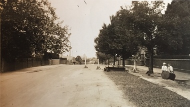
Photograph - Street Works, Studley Park Road, March 1934
... Street Works, Studley Park Road...street works -- kew (vic.)...public works kew (vic.)...studley...Studley Park Road, like most streets in Kew, was originally a dirt road. ...Original sepia photographic positive of Studley Park Road, Kew while resurfacing of the street was taking place. ...Photograph Street Works, Studley Park Road ...Studley Park Road, like most streets in Kew, was originally a dirt road. Street works during the Great Depression included bituminising major roads in the district. This photograph of Council works originated in the City of Kew Engineers Department as a record of works undertaken. It was given to the collection by a Mrs Fisher in 1998.Well provenanced photograph of Council-funded public works in Kew during the Great Depression. Original sepia photographic positive of Studley Park Road, Kew while resurfacing of the street was taking place. The Kew Junction is just visible in the distance. Boys sitting on a drum at right. Behind them is the brick fence and front entrance to Tara Hall.Typed reverse: "B4 / Kew C.C. / Studley Park Road showing drag spread surfacing with premixed material, unrolled material on the right, March 1934"roadworks -- kew (vic.), street works -- kew (vic.), public works kew (vic.), studley park road -- kew (vic.), city of kew -- engineers department, city of kew -- public works -- great depression -- 1930s -
 Kew Historical Society Inc
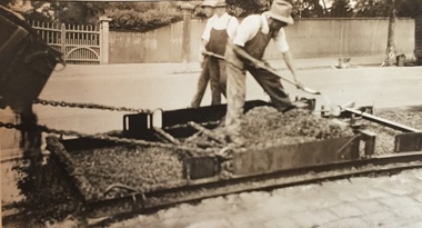
Photograph - Street Works, Studley Park Road, March 1934
... Street Works, Studley Park Road...street works -- kew (vic.)...public works kew (vic.)...studley...Studley Park Road, like most streets in Kew, was originally a dirt road. ...Original sepia photographic positive of Studley Park Road, Kew while resurfacing of the street was taking place. ...Photograph Street Works, Studley Park Road ...Studley Park Road, like most streets in Kew, was originally a dirt road. Street works during the Great Depression included bituminising major roads in the district. This photograph of Council works originated in the City of Kew Engineers Department as a record of works undertaken. It was given to the collection by a Mrs Fisher in 1998.Well provenanced photograph of Council-funded public works in Kew during the Great Depression. Original sepia photographic positive of Studley Park Road, Kew while resurfacing of the street was taking place. Typed reverse: "B4 / Kew C.C. / Spreading premixed material on Studley Park Road with drag spreader, March 1934"roadworks -- kew (vic.), street works -- kew (vic.), public works kew (vic.), studley park road -- kew (vic.), city of kew -- engineers department, city of kew -- public works -- great depression -- 1930s -
 Ballarat Heritage Services
Photograph - Photograph - Colour, 33 Wills St, Kew, c1973, c1973
... A brick building in Wills Street, Studley Park, Kew....In the 1980s and 1990s this property was owned by Pedro and Isobel Jiminez. 33 wills st kew pedro jiminez isobel jiminez A brick building in Wills Street, Studley Park, Kew. 33 Wills St, Kew, c1973 Photograph Photograph - Colour ...In the 1980s and 1990s this property was owned by Pedro and Isobel Jiminez.A brick building in Wills Street, Studley Park, Kew.33 wills st, kew, pedro jiminez, isobel jiminez -
 Kew Historical Society Inc
Photograph - Kew Junction, Herald & Weekly Times, 1962
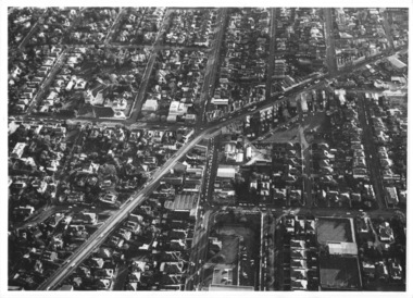
... ...high street kew...studley...An aerial photograph of Kew Junction, showing the intersection of High Street South, Studley Park Road, Princess Street, High Street and Denmark Street. ...An aerial photograph of Kew Junction, showing the intersection of High Street South, Studley Park Road, Princess Street, High Street and Denmark Street. ...This is an aerial oblique image looking north. It shows Kew Junction before construction of VicRoads (Country Roads Board), Murphy's (Leo's) supermarket, and office towers. It also shows a building on the land now known as the Raoul Wallenberg Reserve, the Kew Municipal Offices in Walpole Street, and St Paul's School for the Blind in Fernhurst Grove, and Kew Bowling Club in Wellington Street.An aerial photograph of Kew Junction, showing the intersection of High Street South, Studley Park Road, Princess Street, High Street and Denmark Street. A number of buildings, now demolished can be identified in the photo, including Jellis’ Bakeries on the corner of Princess Street and Studley Park Road." Annotation on reverse: "Kew Historical Society from Mr L. H. Chinner".kew junction, aerial photograph (kew), oblique aerial, st paul's school for the blind, kew municipal offices, high street kew, studley park road, kew war memorial, kew post office, kew police station, kew court house, high street south, kew, wellington street kew, denmark street kew -
 Kew Historical Society Inc
Functional object - Gravure Printing Plate for Mr & Mrs HW Tompkins
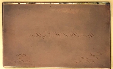
... Tompkins, Fenwick, Fenwick Street, Studley Park / PPC 1st Friday"...Tompkins, Fenwick, Fenwick Street, Studley Park / PPC 1st Friday" Copper (on steel?) ...Henry (Harry) William Tompkins was a renowned Melbourne architect, former City of Kew councillor and sometime Mayor of the municipality. He was president of the Melbourne Institute of Architects in 1914-15. In partnership with his brother, Frank Beauchamp Tompkins, he designed the Myer Stores in Bourke and Lonsdale Streets in 1933. Locally he was the architect of the Kew War Memorial (opened 1925). At the time that the gravure plate was made, the couple lived in 'Fenwick', a house on the corner of Stawell Street and Fenwick Street, Kew, which has since been demolished.Copper (on steel?) gravure printing plate made for Mr & Mrs Harold Tompkins, 'Fenwick', Fenwick Street, Kew. Engraved in reverse script. It is assumed that the acronym PPC may stand for 'Please Present Card'. "Mr & Mrs H.W. Tompkins, Fenwick, Fenwick Street, Studley Park / PPC 1st Friday"harry tompkins, gravure printing plates, business cards -
 Kew Historical Society Inc
Document - Document [copy], Birthday Verses, 31 July 1886, 1886
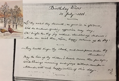
... street - kew )vic)...historic buidlings - studley park - kew (vic)...2 page copy of birthday verses written by Thomas Brodribb of Hallatrow, 6 Holroyd Street, Studley Park in 1886. The verses celebrate his wife Emily. ...The house is located at 6 Holroyd Street. hallatrow - 6 holroyd street - kew )vic) historic buidlings - studley park - kew (vic) 2 page copy of birthday verses written by Thomas Brodribb of Hallatrow, 6 Holroyd Street, Studley Park in 1886. ...Hallatrow was the home of Thomas Brodribb. The house is located at 6 Holroyd Street.2 page copy of birthday verses written by Thomas Brodribb of Hallatrow, 6 Holroyd Street, Studley Park in 1886. The verses celebrate his wife Emily. hallatrow - 6 holroyd street - kew )vic), historic buidlings - studley park - kew (vic) -
 Kew Historical Society Inc
Plan, Melbourne & Metropolitan Board of Works : Borough of Kew : Detail Plan No.1350, 1910
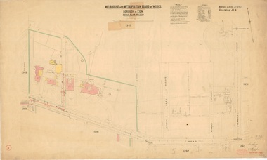
... : Yarra Street, Studley Park Avenue, Studley Street and Fenwick Street. ...: Yarra Street, Studley Park Avenue, Studley Street and Fenwick Street. ...The Melbourne and Metropolitan Board of Works (MMBW) plans were produced from the 1890s to the 1950s. They were crucial to the design and development of Melbourne's sewerage and drainage system. The plans, at a scale of 40 feet to 1 inch (1:480), provide a detailed historical record of Melbourne streetscapes and environmental features. Each plan covers one or two street blocks (roughly six streets), showing details of buildings, including garden layouts and ownership boundaries, and features such as laneways, drains, bridges, parks, municipal boundaries and other prominent landmarks as they existed at the time each plan was produced. (Source: State Library of Victoria). This plan forms part of a large group of MMBW plans and maps that was donated to the Society by the Mr Poulter, City Engineer of the City of Kew in 1989. Within this collection, thirty-five hand-coloured plans, backed with linen, are of statewide significance as they include annotations that provide details of construction materials used in buildings in the first decade of the 20th century as well as additional information about land ownership and usage. The copies in the Public Record Office Victoria and the State Library of Victoria are monochrome versions which do not denote building materials so that the maps in this collection are invaluable and unique tools for researchers and heritage consultants. A number of the plans are not held in the collection of the State Library of Victoria so they have the additional attribute of rarity.Original survey plan, issued by the MMBW to a contractor with responsibility for constructing sewers in the area identified on the plan within the Borough of Kew. The plan was at some stage hand-coloured, possibly by the contractor, but more likely by officers working in the Engineering Department of the Borough and later Town, then City of Kew. The hand-coloured sections of buildings on the plan were used to denote masonry or brick constructions (pink), weatherboard constructions (yellow), and public buildings (grey). MMBW Plan No. 1350 depicts the western end of Studley Park on the north side of the Studley Park Road. ‘Raheen’, then the home of Sir Henry Wrixon is named, the plan identifying those parts of the house that were built of brick and timber. The two houses between Raheen and the River Yarra are also shown. Other parts of the plan show neighbouring streets: Yarra Street, Studley Park Avenue, Studley Street and Fenwick Street. Each, apart from Fenwick Street was subsequently renamed. At the corner of Fenwick and Stawell Streets, the home of Joseph Butterworth Coombs, later called ‘Hope Mansell’, is represented but unnamed.melbourne and metropolitan board of works, detail plans, mmbw 1350, cartography -
![Toast 25-5-1986 [Hallatrow]](/media/collectors/550653872162f11fb04854aa/items/5e3037ba21ea6717786eae87/item-media/5e3038b121ea6717786f92e1/item-fit-380x285.jpg?cb=6) Kew Historical Society Inc
Kew Historical Society IncDocument, Toast 25-5-1986 [Hallatrow], 1986
... street - kew )vic)...historic buidlings - studley park - kew (vic)...A manuscript, written by Jim Brodribb, the grandson of Thomas Brodribb, the original owner of Hallatrow, recalling his family's years at Hallatrow (now 6 Holroyd Street in Studley Park.) ...The notes were written by his descendant and recall his family's occupation of the house. hallatrow - 6 holroyd street - kew )vic) historic buidlings - studley park - kew (vic) A manuscript, written by Jim Brodribb, the grandson of Thomas Brodribb, the original owner of Hallatrow, recalling his family's years at Hallatrow (now 6 Holroyd Street in Studley Park.) ...Hallatrow is located at 6 Holroyd Street Kew. It was the home of Thomas Brodribb. The notes were written by his descendant and recall his family's occupation of the house.A manuscript, written by Jim Brodribb, the grandson of Thomas Brodribb, the original owner of Hallatrow, recalling his family's years at Hallatrow (now 6 Holroyd Street in Studley Park.) hallatrow - 6 holroyd street - kew )vic), historic buidlings - studley park - kew (vic) -
 Kew Historical Society Inc
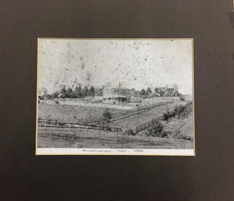
Photograph, 'Hallatrow', Holroyd Street, Kew, 1886, 1886
... street - kew )vic)...historic buidlings - studley park - kew (vic)...What appears to be a reprint of an earlier photograph of Hallatrow, now mounted, originally listed as A'Beckett Street West or Conran Street, but now 6 Holroyd Street in Studley Park. The photograph was originally taken when the house was occupied by the family of Thomas Brodribb. ...An important early photograph of a significant Kew mansion - Hallatrow - dating from 1886, soon after it was constructed. hallatrow - 6 holroyd street - kew )vic) historic buidlings - studley park - kew (vic) Pencil: “Hallatrow, Kew, 1886” What appears to be a reprint of an earlier photograph of Hallatrow, now mounted, originally listed as A'Beckett Street West or Conran Street, but now 6 Holroyd Street in Studley Park. ...An important early photograph of a significant Kew mansion - Hallatrow - dating from 1886, soon after it was constructed.What appears to be a reprint of an earlier photograph of Hallatrow, now mounted, originally listed as A'Beckett Street West or Conran Street, but now 6 Holroyd Street in Studley Park. The photograph was originally taken when the house was occupied by the family of Thomas Brodribb. Pencil: “Hallatrow, Kew, 1886” hallatrow - 6 holroyd street - kew )vic), historic buidlings - studley park - kew (vic) -
 Kew Historical Society Inc
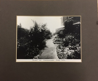
Photograph, Snow at Hallatrow, Aug 1899, 1899
... street - kew )vic)...historic buidlings - studley park - kew (vic)...What appears to be a reprint of an earlier photograph of Hallatrow, now mounted, originally listed as A'Beckett Street West or Conran Street, but now 6 Holroyd Street in Studley Park. The photograph was originally taken when the house was occupied by the family of Thomas Brodribb. ...An important early photograph of a significant Kew mansion - Hallatrow - dating from 1899. hallatrow - 6 holroyd street - kew )vic) historic buidlings - studley park - kew (vic) Pencil: “Snow at Hallatrow, Aug 1899” What appears to be a reprint of an earlier photograph of Hallatrow, now mounted, originally listed as A'Beckett Street West or Conran Street, but now 6 Holroyd Street in Studley Park. ...An important early photograph of a significant Kew mansion - Hallatrow - dating from 1899.What appears to be a reprint of an earlier photograph of Hallatrow, now mounted, originally listed as A'Beckett Street West or Conran Street, but now 6 Holroyd Street in Studley Park. The photograph was originally taken when the house was occupied by the family of Thomas Brodribb. Pencil: “Snow at Hallatrow, Aug 1899” hallatrow - 6 holroyd street - kew )vic), historic buidlings - studley park - kew (vic) -
 Kew Historical Society Inc
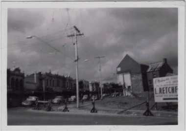
Photograph - Kew Junction during road widening, December 1958
... Kew Junction is the intersection of five major roads - Denmark Street, High Street, High Street South, Studley Park Road and Princess Street. ...Kew Junction is the intersection of five major roads - Denmark Street, High Street, High Street South, Studley Park Road and Princess Street. ...Kew Junction is the intersection of five major roads - Denmark Street, High Street, High Street South, Studley Park Road and Princess Street. The original widening of High Street in the 1930s expanded that street by removing shops on the south side of the street from Cotham Road to Denmark Street. Further widening in 1958 removed shops at the west end of High Street to allow for increased traffic using Princes Street and Denmark Street.Original, black and white positive of Kew Junction, including the corner with Denmark Street during road widening in the 1958.Inscribed verso: "Kew Junction Dec 1958 / When the road was being widened by the removal of a number of shops / Notice saying Retchford's Estate agency's temporary office is at the top end of Denmark Street, Kew"kew junction, denmark street -- kew (vic.), major roadworks -- kew (vic.) -
 Kew Historical Society Inc
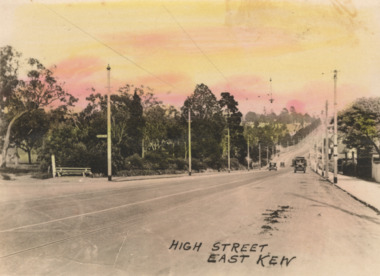
Postcard - High Street, East Kew, c.1927
... High Street progresses through a number of significant road junctions: beginning at Barkers Road; progressing through the intersection of Studley Park Road, Denmark Street and Princess Street at Kew Junction; branching left at the junction with Cotham Road; before reaching the junction with Valerie Street and Harp Road. ...High Street progresses through a number of significant road junctions: beginning at Barkers Road; progressing through the intersection of Studley Park Road, Denmark Street and Princess Street at Kew Junction; branching left at the junction with Cotham Road; before reaching the junction with Valerie Street and Harp Road. ...High Street, Kew is the main Road in Kew. It was once also known as Bulleen Road, or Main Street. This section of the road is in Kew, although the narrow section on the right hand side of the photo is now Kew East. High Street progresses through a number of significant road junctions: beginning at Barkers Road; progressing through the intersection of Studley Park Road, Denmark Street and Princess Street at Kew Junction; branching left at the junction with Cotham Road; before reaching the junction with Valerie Street and Harp Road. It reaches its end at the junction of Burke Road, Kilby Road, Bulleen Road and High Street itself. An early photograph of this iconic Memorial that locates it in its context. Small, colorised real photo postcard of High Street, East Kew. Electric light poles line the road. Victoria Park is on the left and further on the horizon is the Boroondara General Cemetery.high street -- kew (vic.), victoria park, tram lines -- kew (vic.) -
 Kew Historical Society Inc
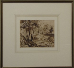
Work on paper - Sepia Wash & Ink, G B Richardson, Creek and Old Watering Stage, on the Yarra, East Collingwood, 1854, 1854
... The Punt was purchased by the Colonial Government in 1852 and was in use until the opening of the Studley Park Road (Johnston Street) Bridge in 1858 made its continued use redundant...The Punt was purchased by the Colonial Government in 1852 and was in use until the opening of the Studley Park Road (Johnston Street) Bridge in 1858 made its continued use redundant The watercolour is historically significant as perhaps the earliest artwork showing the Yarra River at Kew. ...Blind Creek was located between the Abbotsford Convent and what is now the Collins Bridge in Studley Park. In an 1858 map of East Collingwood by Clement Hodgkinson, in the State Library of Victoria, one can see how the creek was originally a significant landmark in Collingwood; remaining vacant land until a barrel drain enclosed it. The area was later filled in, surveyed and developed. The position where Blind Creek entered the Yarra was in the immediate vicinity of Hodgson’s Punt, which had linked Kew to the other side of the Yarra from 1839. The Punt was purchased by the Colonial Government in 1852 and was in use until the opening of the Studley Park Road (Johnston Street) Bridge in 1858 made its continued use redundantThe point of view selected by the artist for the watercolour is from the banks of Blind Creek in East Collingwood, looking across the Yarra to the Kew side of the river.Inscribed verso 'Creek and Old Watering stage, on the Yarra East Collingwood 1854 / Trees, stage, &c have long since disappeared / [Artist Signature] / FT 110 / Creek itself now being filled in 1903.gb richardson, blind creek - abbotsford, yarra river - abbotsford (vic) - kew (vic), colonial artists, australian art - 19th century, george bouchier richardson -
 Kew Historical Society Inc
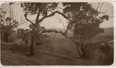
Photograph - Studley Park, 1937
... Those sections of Studley Park bounded by the Yarra River, Studley Park Road, Princess Street and Fellows Street were subdivided and sold at the Crown Land Sales in 1851. ...Those sections of Studley Park bounded by the Yarra River, Studley Park Road, Princess Street and Fellows Street were subdivided and sold at the Crown Land Sales in 1851. ...Those sections of Studley Park closest to the River Yarra were set aside as parkland in the 1850s. After initial discussions about whether it was a suitable site for a Government House, much of the land was instead gazetted in the 1860s as the location for a new lunatic asylum, to expand overcrowded mental health facilities at the Yarra Bend Asylum on the other side of the river at Fairfield. Those sections of Studley Park bounded by the Yarra River, Studley Park Road, Princess Street and Fellows Street were subdivided and sold at the Crown Land Sales in 1851. Much of this urban area remained open farmland until the twentieth century, apart from mansions, largely located along the main roads.Original, black and white positive print of what is said to represent Studley Park in 1937. If the attribution and date is literally to be understood, then it would appear that the photograph may have been taken from the Kew side of the river looking across to open farmland in the Yarra Bend Park. If the designation of Studley Park is to be understood more loosely, then it might be a view of what is now East Kew, taken from a section of Kilby Road. Inscribed verso: "Studley Park 1937" studley park -- kew (vic.) -
 Kew Historical Society Inc
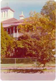
Photograph - 'Fernhurst', 13 Fernhurst Grove, 1978
... Originally accessed from near the corner of Princess Street and Studley Park Road, its gardens had been subdivided in the 1900s and its footprint restricted to 13 Fernhurst Grove. ...Originally accessed from near the corner of Princess Street and Studley Park Road, its gardens had been subdivided in the 1900s and its footprint restricted to 13 Fernhurst Grove. ...George Wharton arrived in Melbourne in 1844. An architect and surveyor, he was appointed to lay out the 'Village of Kew' by N.A. Fenwick following the land sales of 1851. A protagonist for Kew's separation from the Boroondara District Road Board, he was elected chairman when Kew achieved municipal status in December 1860. His home, 'Fernhurst', was built in 1866 on eight acres in Studley Park, with a four-storey tower and pyramidal roof. The Italianate home was a prominent Kew landmark. It was demolished in 1979 and replaced by St Paul's College in 1980.Rare colour photograph of what was once a significant mansion in Kew.Original colour positive photograph (Kodak print) of 'Fernhurst' in 1978. Photographed by Stewart West in May 1978, one year before it was demolished, the photograph gives little idea of the large landholding once surrounding the house. Originally accessed from near the corner of Princess Street and Studley Park Road, its gardens had been subdivided in the 1900s and its footprint restricted to 13 Fernhurst Grove. Like many other grand houses, by the 1970s it had been converted into apartments. From the photograph, one can see that the house had retained many of its original features such as the distinctive tower and the wide bow-fronted verandah. The slates on the roof (apart from those on the tower) had been replaced by tiles and the cement render of the exterior painted white. Annotated reverse: "View of Fernhurst Home Taken from Street / 10"fernhurst, 13 fernhurst grove -- kew (vic.), george wharton, italianate architecture, vila maria society, st paul's school for the blind -
 Kew Historical Society Inc
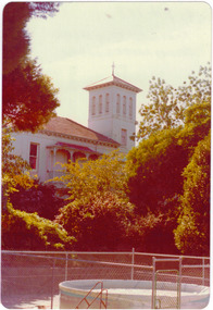
Photograph - 'Fernhurst', 13 Fernhurst Grove, 1978
... Originally accessed from near the corner of Princess Street and Studley Park Road, its gardens had been subdivided in the 1900s and its footprint restricted to 13 Fernhurst Grove. ...Originally accessed from near the corner of Princess Street and Studley Park Road, its gardens had been subdivided in the 1900s and its footprint restricted to 13 Fernhurst Grove. ...George Wharton arrived in Melbourne in 1844. An architect and surveyor, he was appointed to lay out the 'Village of Kew' by N.A. Fenwick following the land sales of 1851. A protagonist for Kew's separation from the Boroondara District Road Board, he was elected chairman when Kew achieved municipal status in December 1860. His home, 'Fernhurst', was built in 1866 on eight acres in Studley Park, with a four-storey tower and pyramidal roof. The Italianate home was a prominent Kew landmark. It was demolished in 1979 and replaced by St Paul's College in 1980.Rare colour photograph of what was once a significant mansion in Kew.Original colour positive photograph (Kodak print) of 'Fernhurst' in 1978. Photographed by Stewart West in May 1978, one year before it was demolished, the photograph gives little idea of the large landholding once surrounding the house. Originally accessed from near the corner of Princess Street and Studley Park Road, its gardens had been subdivided in the 1900s and its footprint restricted to 13 Fernhurst Grove. Like many other grand houses, by the 1970s it had been converted into apartments. From the photograph, one can see that the house had retained many of its original features such as the distinctive tower and the wide bow-fronted verandah. The slates on the roof (apart from those on the tower) had been replaced by tiles and the cement render of the exterior painted white. Annotated reverse: "Fernhurst from higher ground level side shot / 7"fernhurst, 13 fernhurst grove -- kew (vic.), george wharton, italianate architecture, vila maria society, st paul's school for the blind -
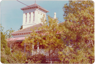 Kew Historical Society Inc
Photograph - 'Fernhurst', 13 Fernhurst Grove, 1978
... Originally accessed from near the corner of Princess Street and Studley Park Road, its gardens had been subdivided in the 1900s and its footprint restricted to 13 Fernhurst Grove. ...Originally accessed from near the corner of Princess Street and Studley Park Road, its gardens had been subdivided in the 1900s and its footprint restricted to 13 Fernhurst Grove. ...George Wharton arrived in Melbourne in 1844. An architect and surveyor, he was appointed to lay out the 'Village of Kew' by N.A. Fenwick following the land sales of 1851. A protagonist for Kew's separation from the Boroondara District Road Board, he was elected chairman when Kew achieved municipal status in December 1860. His home, 'Fernhurst', was built in 1866 on eight acres in Studley Park, with a four-storey tower and pyramidal roof. The Italianate home was a prominent Kew landmark. It was demolished in 1979 and replaced by St Paul's College in 1980.Rare colour photograph of what was once a significant mansion in Kew.Original colour positive photograph (Kodak print) of 'Fernhurst' in 1978. Photographed by Stewart West in May 1978, one year before it was demolished, the photograph gives little idea of the large landholding once surrounding the house. Originally accessed from near the corner of Princess Street and Studley Park Road, its gardens had been subdivided in the 1900s and its footprint restricted to 13 Fernhurst Grove. Like many other grand houses, by the 1970s it had been converted into apartments. From the photograph, one can see that the house had retained many of its original features such as the distinctive tower and the wide bow-fronted verandah. The slates on the roof (apart from those on the tower) had been replaced by tiles and the cement render of the exterior painted white. Annotated reverse: "Back view of Fernhurst / 8"fernhurst, 13 fernhurst grove -- kew (vic.), george wharton, italianate architecture, vila maria society, st paul's school for the blind -
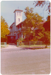 Kew Historical Society Inc
Photograph - 'Fernhurst', 13 Fernhurst Grove, 1978
... Originally accessed from near the corner of Princess Street and Studley Park Road, its gardens had been subdivided in the 1900s and its footprint restricted to 13 Fernhurst Grove. ...Originally accessed from near the corner of Princess Street and Studley Park Road, its gardens had been subdivided in the 1900s and its footprint restricted to 13 Fernhurst Grove. ...George Wharton arrived in Melbourne in 1844. An architect and surveyor, he was appointed to lay out the 'Village of Kew' by N.A. Fenwick following the land sales of 1851. A protagonist for Kew's separation from the Boroondara District Road Board, he was elected chairman when Kew achieved municipal status in December 1860. His home, 'Fernhurst', was built in 1866 on eight acres in Studley Park, with a four-storey tower and pyramidal roof. The Italianate home was a prominent Kew landmark. It was demolished in 1979 and replaced by St Paul's College in 1980.Rare colour photograph of what was once a significant mansion in Kew.Original colour positive photograph (Kodak print) of 'Fernhurst' in 1978. Photographed by Stewart West in May 1978, one year before it was demolished, the photograph gives little idea of the large landholding once surrounding the house. Originally accessed from near the corner of Princess Street and Studley Park Road, its gardens had been subdivided in the 1900s and its footprint restricted to 13 Fernhurst Grove. Like many other grand houses, by the 1970s it had been converted into apartments. From the photograph, one can see that the house had retained many of its original features such as the distinctive tower and the wide bow-fronted verandah. The slates on the roof (apart from those on the tower) had been replaced by tiles and the cement render of the exterior painted white. Annotated reverse: "Fernhurst front view taken from across Fernhurst Grove / 6"fernhurst, 13 fernhurst grove -- kew (vic.), george wharton, italianate architecture, vila maria society, st paul's school for the blind -
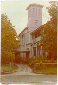 Kew Historical Society Inc
Photograph - 'Fernhurst', 13 Fernhurst Grove, 1978
... Originally accessed from near the corner of Princess Street and Studley Park Road, its gardens had been subdivided in the 1900s and its footprint restricted to 13 Fernhurst Grove. ...Originally accessed from near the corner of Princess Street and Studley Park Road, its gardens had been subdivided in the 1900s and its footprint restricted to 13 Fernhurst Grove. ...George Wharton arrived in Melbourne in 1844. An architect and surveyor, he was appointed to lay out the 'Village of Kew' by N.A. Fenwick following the land sales of 1851. A protagonist for Kew's separation from the Boroondara District Road Board, he was elected chairman when Kew achieved municipal status in December 1860. His home, 'Fernhurst', was built in 1866 on eight acres in Studley Park, with a four-storey tower and pyramidal roof. The Italianate home was a prominent Kew landmark. It was demolished in 1979 and replaced by St Paul's College in 1980.Rare colour photograph of what was once a significant mansion in Kew.Original colour positive photograph (Kodak print) of 'Fernhurst' in 1978. Photographed by Stewart West in May 1978, one year before it was demolished, the photograph gives little idea of the large landholding once surrounding the house. Originally accessed from near the corner of Princess Street and Studley Park Road, its gardens had been subdivided in the 1900s and its footprint restricted to 13 Fernhurst Grove. Like many other grand houses, by the 1970s it had been converted into apartments. From the photograph, one can see that the house had retained many of its original features such as the distinctive tower and the wide bow-fronted verandah. The slates on the roof (apart from those on the tower) had been replaced by tiles and the cement render of the exterior painted white. Annotated reverse: "Front view of Fernhurst showing tower to advantage / 9"fernhurst, 13 fernhurst grove -- kew (vic.), george wharton, italianate architecture, vila maria society, st paul's school for the blind -
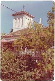 Kew Historical Society Inc
Photograph - 'Fernhurst', 13 Fernhurst Grove, 1978
... Originally accessed from near the corner of Princess Street and Studley Park Road, its gardens had been subdivided in the 1900s and its footprint restricted to 13 Fernhurst Grove. ...Originally accessed from near the corner of Princess Street and Studley Park Road, its gardens had been subdivided in the 1900s and its footprint restricted to 13 Fernhurst Grove. ...George Wharton arrived in Melbourne in 1844. An architect and surveyor, he was appointed to lay out the 'Village of Kew' by N.A. Fenwick following the land sales of 1851. A protagonist for Kew's separation from the Boroondara District Road Board, he was elected chairman when Kew achieved municipal status in December 1860. His home, 'Fernhurst', was built in 1866 on eight acres in Studley Park, with a four-storey tower and pyramidal roof. The Italianate home was a prominent Kew landmark. It was demolished in 1979 and replaced by St Paul's College in 1980.Rare colour photograph of what was once a significant mansion in Kew.Original colour positive photograph (Kodak print) of 'Fernhurst' in 1978. Photographed by Stewart West in May 1978, one year before it was demolished, the photograph gives little idea of the large landholding once surrounding the house. Originally accessed from near the corner of Princess Street and Studley Park Road, its gardens had been subdivided in the 1900s and its footprint restricted to 13 Fernhurst Grove. Like many other grand houses, by the 1970s it had been converted into apartments. From the photograph, one can see that the house had retained many of its original features such as the distinctive tower and the wide bow-fronted verandah. The slates on the roof (apart from those on the tower) had been replaced by tiles and the cement render of the exterior painted white. Annotated reverse: "Fernhurst corner shot through trees / 12-22"fernhurst, 13 fernhurst grove -- kew (vic.), george wharton, italianate architecture, vila maria society, st paul's school for the blind -
 Kew Historical Society Inc
Archive (Sub-series) - Subject File, Fernhurst (Kew), 1973
... Archive file containing research related to George Wharton (q.v) and his house Fernhurst, originally situated on the corner of Princess Street and Studley Park Road, but later subdivided. ...Typically files will contain primary and secondary sources. kew (vic) - history victorian architects - george wharton fernhurst (kew) st paul’s school for the blind Archive file containing research related to George Wharton (q.v) and his house Fernhurst, originally situated on the corner of Princess Street and Studley Park Road, but later subdivided. ...Various partiesReference, Research, InformationSecondary Values (KHS Imposed Order)Subject file containing research related to George Wharton and his house Fernhurst, originally situated on the corner of Princess Street and Studley Park Road, but later subdivided. The house was in the 20th century converted into flats and later bought by the Catholic Church, who established St Paul’s School for the Blind on the site. The situation was complicated as the Church also bought the neighbouring Neama and Mandalay. Villa Maria and St Paul’s School currently occupy the site. Part of the site was later subdivided to create Elphinstone Court. The file contains photocopied extracts from histories and detailed research and correspondence between the School, the Kew Historical Society, the National Trust of Victoria, and the Historic Buildings Preservation Council relating to both Neama and Fernhurst. There is a reference in a letter from St Paul’s inviting the Society to collect artefacts from the site. There are no known current items in the collection relating to the collection of these. kew (vic) - history, victorian architects - george wharton, fernhurst (kew), st paul’s school for the blindkew (vic) - history, victorian architects - george wharton, fernhurst (kew), st paul’s school for the blind
