Showing 494 items matching "subdivision map"
-
 Wodonga & District Historical Society Inc
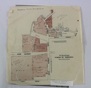
Map - Hamilton-Smith Collection Subdivision Map of Wodonga
... Hamilton-Smith Collection Subdivision Map of Wodonga...Hamilton-Smith Collection Subdivision Map of Wodonga...map...subdivision...A printed map of a Wodonga subdivision with hand written annotations ...A printed map of a Wodonga subdivision with hand written annotations Hamilton-Smith Collection Subdivision Map of Wodonga Map Hamilton-Smith Collection Subdivision Map of Wodonga ...The Hamilton-Smith collection was donated by the children of Grace Mary Hamilton-Smith nee Ellwood (1911-2004) and John Hamilton-Smith (1909-1984) who settled in Wodonga in the 1940s. The Ellwood family had lived in north-east Victoria since the late 1800s. Grace’s mother, Rosina Ellwood nee Smale, was the first teacher at Baranduda in 1888, and a foundation member of the C.W.A. Rosina and her husband Mark retired to Wodonga in 1934. Grace and John married at St. David’s Church, Albury in 1941. John was a grazier, and actively involved in Agricultural Societies. The collection contains significant items which reflect the local history of Wodonga, including handmade needlework, books, photographs, a wedding dress, maps, and material relating to the world wars. This item has well documented provenance and a known owner. It forms part of a significant and representative historical collection which reflects the local history of Wodonga. It contributes to our understanding of social and family life in early twentieth century Wodonga, as well as providing interpretative capacity for themes including local history and social history. A printed map of a Wodonga subdivision with hand written annotations On top proper right corner: "Donated by Merrilyn Hamilton-Smith". map, subdivision, wodonga, local history, maps, hamilton-smith, hamilton-smith collection -
 Lorne Historical Society
Map - Subdivision Map, J Batten Lithos, Plan of West Lorne Loutitt Bay Allotments IV and V
... Subdivision Map...One of the early subdivision maps of Lorne....Plan of West Lorne Loutitt Bay Allotments IV and V Map Subdivision Map J Batten Lithos ...One of the early subdivision maps of Lorne.Black and white printed map on cream paper. The map shows allotments from the Erskine River to the Grand Pacific with an inset of allotments between Smith and Otway Streets. Allotments have the owners names.. The sea baths, Cobb and Co stables , Mountjoys Hotel, the Church of England, the telegraph line to Geelong and the jetty are also marked.lorne, subdivisions, -
 Ringwood and District Historical Society
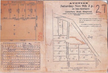
Document, Collage of Residential Subdivision Map Clippings - Ringwood, Victoria - (Undated, circa 1930s)
... Collage of Residential Subdivision Map Clippings - Ringwood, Victoria - (Undated, circa 1930s)...Single page photocopy of 3 unrelated subdivision maps - Five numbered allotments on unidentified section of Warrandyte Road, Ringwood. - 53 numbered allotments on Caroline Street and Henry Street off Greenwood Avenue, Ringwood. - Clipping from a land auction brochure for 40 acres in 3 and 4 acre lots marked as Miller's Estate - Miller Street off Canterbury Road, Heathmont, Vic....Collage of Residential Subdivision Map Clippings - Ringwood, Victoria - (Undated, circa 1930s) Document ...Single page photocopy of 3 unrelated subdivision maps - Five numbered allotments on unidentified section of Warrandyte Road, Ringwood. - 53 numbered allotments on Caroline Street and Henry Street off Greenwood Avenue, Ringwood. - Clipping from a land auction brochure for 40 acres in 3 and 4 acre lots marked as Miller's Estate - Miller Street off Canterbury Road, Heathmont, Vic.(Auction) Under instructions from the Equity Trustee Co. Ltd., in the Estate of F.J. and K. Millar Deceased. -
 Ringwood and District Historical Society
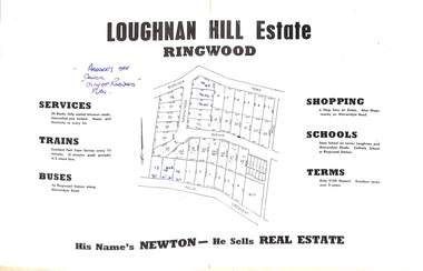
Document - Folder, Subdivision Map - Loughnan Hill Estate, Ringwood, Victoria - circa 1960
... Subdivision Map - Loughnan Hill Estate, Ringwood, Victoria - circa 1960....Agent - T.G. Newton. Subdivision Map - Loughnan Hill Estate, Ringwood, Victoria - circa 1960. ...Open centre page of land sale brochure glued to manilla folder. Map of residential and shop sites in Burlock Road (later Burlock Avenue), Adolphson Avenue and Felix Crescent, Ringwood, with summary of estate facilities and local services. Agent - T.G. Newton.(Page glued to manilla folder prevents access to front page for further sale information) -
 Ringwood and District Historical Society
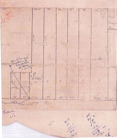
Document, Subdivision Map - Unsworth Road, Ringwood, Victoria (Undated)
... Subdivision Map - Unsworth Road, Ringwood, Victoria (Undated)...Single page photocopy of hand-drawn map - 9 numbered residential allotments with imperial measurements. Subdivision Map - Unsworth Road, Ringwood, Victoria (Undated) Document ...Single page photocopy of hand-drawn map - 9 numbered residential allotments with imperial measurements.Handwritten pen notations include land title reference - LP111235. -
 Ringwood and District Historical Society
Card - Double-sided Display, Land Subdivision Map Samples
... Land Subdivision Map Samples...Side 2 - Extract from Land Auction advertisement for sale of 23 allotments in Ridge Road, Oakley Street and Mount Dandenong Tourist Road, Mount Dandenong, Victoria - circa 1950s. Land Subdivision Map Samples Card Double-sided Display ...Side 1 - Layout of 20 residential allotments in Shasta Avenue, Merrilong Street, Northwood Street and Alexandra Road, Ringwood East, Victoria (Undated). Side 2 - Extract from Land Auction advertisement for sale of 23 allotments in Ridge Road, Oakley Street and Mount Dandenong Tourist Road, Mount Dandenong, Victoria - circa 1950s. -
 Ringwood and District Historical Society
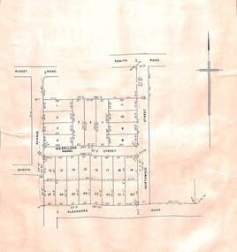
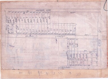
Document, Subdivision Map (Undated) - Ringwood, Victoria
... Subdivision Map (Undated) - Ringwood, Victoria... plan showing numbered residential allotments with property dimensions. Subdivision Map (Undated) - Ringwood, Victoria Document ...Hand-drawn copy of subdivision plan showing numbered residential allotments with property dimensions.Map includes Wantirna Road, Ireland Street, City Road and Victoria Street (later Regina Street), Ringwood, Victoria. -
 Ringwood and District Historical Society
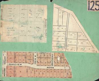
Card, Collage of Residential Subdivision Map Clippings - Ringwood, Victoria - (Undated)
... Collage of Residential Subdivision Map Clippings - Ringwood, Victoria - (Undated)...Collage of Residential Subdivision Map Clippings - Ringwood, Victoria - (Undated) Card ...Three maps mounted on green cardboard - Hand-drawn map of residential allotments off Warrandyte Road in Milne Road and Berringa Road Park Orchards. Map with acres roods and perches measurements of allotments in Canterbury Road and Miller Street Heathmont. Clipping from a land sale brochure with street names not existing together in the area - Rangeview Avenue, Press Avenue and Mountview Avenue. -
 Ringwood and District Historical Society
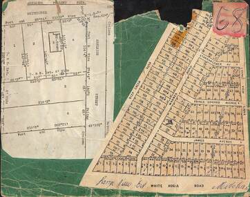
Card, Collage of Residential Subdivision Map Clippings - Ashleigh Poultry Farm, Blackburn, Vic and Range View East, Mitcham, Vic. (Undated, circa 1930s)
... Collage of Residential Subdivision Map Clippings - Ashleigh Poultry Farm, Blackburn, Vic and Range View East, Mitcham, Vic. ...Collage of Residential Subdivision Map Clippings - Ashleigh Poultry Farm, Blackburn, Vic and Range View East, Mitcham, Vic. ...Weekly Times (Melbourne, Vic.) Sat 24 Aug 1935 Page 6 - 1800 Chickens Burnt. Starting in the incubator room, a fire at the Ashleigh Poultry Farm, Whitehorse Road Blackburn, early on August 20, incinerated 1800 young chickens and 1000 eggs. The incubator room and the chicken pens were reduced to ashes, but a large drum of kerosene standing in the room was undamaged! The owners of the farm, Mrs N. Foote and her sons, have suffered a severe setback, as practically all their chickens and eggs are gone, and it is too late to start hatching again this season.Two maps mounted on green cardboard. 1. Ashleigh Poultry Farm - Layout of weatherboard house and six residential allotments on Whitehorse Road and Ashleigh Street (later Ashburn Place), Blackburn, Victoria. 2. 140 allotments with frontages on Deep Creek Road, Warnes Road, Range View Grove, Tarrangower Avenue, Prince Edward Avenue, James Avenue and White Horse Road, Mitcham, Victoria. -
 Croydon Conservation Society Inc.
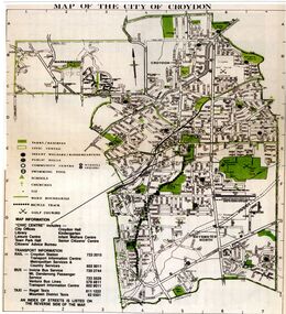
Map, City of Croydon map and subdivision map, September 1961 or 1981
... City of Croydon map and subdivision map, September 1961 or 1981...Two pages, one page map of Croydon and one page a sub division City of Croydon map and subdivision map, September 1961 or 1981 Map ...Two pages, one page map of Croydon and one page a sub division -
 Ringwood and District Historical Society
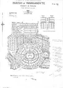
Document - Subdivision Map, Part of Crown Sections 18, 19, 24 & 25, Parish of Warrandyte, County of Evelyn, Vol 5228 Fol 472 - 1926. (Park Orchards, Victoria)
... Subdivision Map...(Park Orchards, Victoria) Document Subdivision Map ...A3 and A4 sized photocopies showing map section of land title showing streets, easements and allotment numbers, some with handwritten names and pricing notations circa mid 1950s.Map includes Valley Road, Granard Avenue, Park Road, Arundel Avenue, Hylton Avenue, Aviemore Avenue, Bowmore Avenue, Hopetoun Road, Colin Avenue, Daintree Avenue, Brucedale Crescent, Feversham Avenue, Ennismore Crescent, Iona Grove, Elgin Crescent and Gosford Crescent, Park Orchards, Victoria. -
 Ringwood and District Historical Society
Document - Subdivision Map, Layout of 72 residential allotments off Oban Road, Ringwood, Victoria - (Undated, circa 1960s)
... Subdivision Map...Foolscap size page Layout of 72 residential allotments off Oban Road, Ringwood, Victoria - (Undated, circa 1960s) Document Subdivision Map ...Foolscap size page Subdivision includes Oban Road, Frederic Drive, Baron Court, Towerhill Drive, Tyson Court, Adele Court, Marilyn Street and Abbey Court, Ringwood. Notations include LP89649. -
 Ringwood and District Historical Society
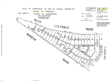
Document - Subdivision Map, Part of Crown Portion 22 Parish of Ringwood, County of Mornington. Vol 1915 Fol 827 - LP2427
... Subdivision Map...Vol 1915 Fol 827 - LP2427 Document Subdivision Map ...LANDATA Land Victoria 4-sheet plan dated January 2003 - copy of original 1889 subdivision, amended with 1947 amendments by Assistant Registrar of Titles.Sheet 1 includes Main Lilydale Road (later Old Lilydale Road), Wandin Road (later Mount Dandenong Road), and Joseph Street, Ringwood East. Additional Plan markings SP30844, SP32804, LP144251, PS332061, PS305232. Sheet 2 includes Main Lilydale Road (later Old Lilydale Road), Wandin Road (later Mount Dandenong Road), and Dynes Street, Ringwood East. Additional Plan markings LP43708, LP44231, LP124702. Sheet 3 includes Main Lilydale Road (later Old Lilydale Road), Dynes Street, Albert Street (later Wyrunga Street), and Carcoola Road, Ringwood East. Additional Plan markings LP114181, LP114180, LP18261, LP214030, LP67300, PS354509, PS335500. Sheet 4 includes Main Lilydale Road (later Old Lilydale Road), Albert Street (later Wyrunga Street), and Carcoola Road, Ringwood East. Additional Plan markings PS315494, PS319495. -
Stawell Historical Society Inc
Map - Subdivision map, Subdivision of North Woodlands Estate Map
... Subdivision map...Subdivision of North Woodlands Estate Map...County of Kara kara A3 photocopy of Map Subdivision of North Woodlands Estate Map Map Subdivision map ...Shows Homestead Cottage and Dam, Plus Shed. Malakoff NavarreA3 photocopy of MapParishes of Malakoff and Navarre. County of Kara karasurvey -
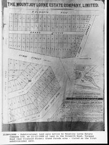 Lorne Historical Society
Map, F W Niven Lithos, The Mountjoy Lorne Estate, 1889
... ...Subdivision map...The land colored red was that of the Mountjoys. The subdivision map was printed in 1889...The land colored red was that of the Mountjoys. The subdivision map was printed in 1889 Lorne Subdivision map Erskine House Mountjoy Brothers A paper map of the Mountjoy Estate Lorne , showing allotments, with their owners, and naming land use. ...In 1888 a company was formed to acquire and subdivide the land of the Mountjoy Brothers. The land totaled 197 acres and included Erskine House. The land colored red was that of the Mountjoys. The subdivision map was printed in 1889A paper map of the Mountjoy Estate Lorne , showing allotments, with their owners, and naming land use. It has four black and white line drawings , Erskine House, Mountain View’s, the Rapids, Erskine House sea view and Erskine Falls. The map is largely black and white with red and blue colouring. The map is mstuck to brown paper. lorne, subdivision map, erskine house, mountjoy brothers, -
Ringwood and District Historical Society
Envelope, Nunawading, Ringwood, East Ringwood Land Subdivision Sales, and Grid Map of Melbourne
... Nunawading, Ringwood, East Ringwood Land Subdivision Sales, and Grid Map of Melbourne...Land Subdivision Sales - Nunawading; Land Subdivision Sales - East Ringwood; Land Subdivision Sales - Ringwood; Land Subdivision Sales - Grid map of Melbourne...Ringwood and District Historical Society 125A Warrandyte Road Ringwood North melbourne Land Subdivision Sales - Nunawading; Land Subdivision Sales - East Ringwood; Land Subdivision Sales - Ringwood; Land Subdivision Sales - Grid map of Melbourne Nunawading, Ringwood, East Ringwood Land Subdivision Sales, and Grid Map of Melbourne Envelope ...Land Subdivision Sales - Nunawading; Land Subdivision Sales - East Ringwood; Land Subdivision Sales - Ringwood; Land Subdivision Sales - Grid map of Melbourne -
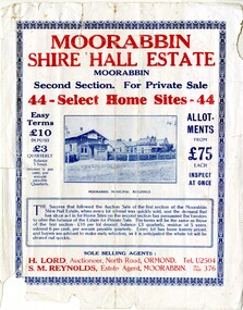 City of Kingston
Pamphlet - Colour, S. M. Reynolds, Estate Agent, Moorabbin Shire Hall Estate Second Section, c. 1930
... Handwritten in grey pencil on subdivision map below subdivision 63: £4 Handwritten in grey pencil on subdivision map below subdivision 66: 4 Handwritten in grey pencil on subdivision map below subdivision 80: 3. ...Land sales estate Moorabbin Handwritten in grey pencil on subdivision map below subdivision 63: £4 Handwritten in grey pencil on subdivision map below subdivision 66: 4 Handwritten in grey pencil on subdivision map below subdivision 80: 3. ...Sales plan for land in the suburb of Moorabbin, bounded by South Road and Highbury Street, including Prince Street, Charming Street, Thomas Avenue and Keith Road.The developing urban area of Moorabbin within the City of Kingston. This land sale pamphlet illustrates the subdivision of land within the municipality and the changing demographic of the district as new houses are constructed close to infrastructure.Colour pamphlet advertising for private sale the Moorabbin Shire Hall Estate, Moorabbin. Incorporates a map of the estate bordered by South Road and Highbury Street, including Prince Street, Charming Street, Keith Road and Thomas Avenue.Handwritten in grey pencil on subdivision map below subdivision 63: £4 Handwritten in grey pencil on subdivision map below subdivision 66: 4 Handwritten in grey pencil on subdivision map below subdivision 80: 3. Handwritten in grey pencil on subdivision map below subdivision 81: 4 Handwritten in grey pencil on subdivision map below subdivision 83: 2 Handwritten in grey pencil on subdivision map below subdivision 96: £3 Handwritten in grey pencil on subdivision map below subdivision 97: 3 Handwritten in grey pencil on subdivision map to the left of subdivision 102: 3 Handwritten in grey pencil on subdivision map on the corner of Thomas Avenue and Highbury Street: vertical line next to a square with a cross in it.land sales, estate, moorabbin -
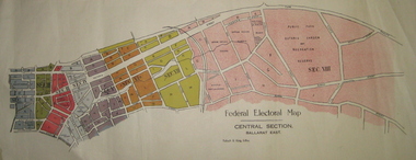 Federation University Historical Collection
Plan - Plans, Tulloch & King, Federal Electoral Map Subdivision of Ballarat, c1901
... Federal Electoral Map Subdivision of Ballarat...The plans include Lake Wendouree, Central Ballarat subdivision; Soldiers Hill subdivision; Ballarat East subdivision, and Central Section Ballarat East, including the Ballarat East Botanic Garden . Federal Electoral Map Subdivision of Ballarat Plan Plans Tulloch & King ...It is thought that these are the first federal electorial plans for the Subdivision of Ballarat. The first member of Ballarat was Alfred Deakin.May of the Federal subdivision of Ballarat, with each section depicted in a different colour. The plans include Lake Wendouree, Central Ballarat subdivision; Soldiers Hill subdivision; Ballarat East subdivision, and Central Section Ballarat East, including the Ballarat East Botanic Garden .ballarat, federation, alfred deakin, elections, plan, electoral division, electoral map, polling -
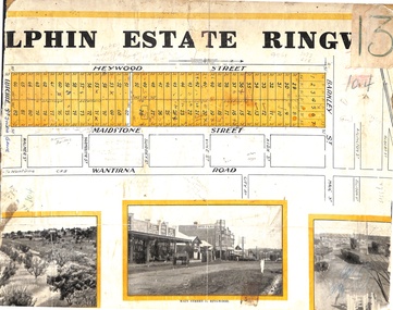 Ringwood and District Historical Society
Map, Partially Trimmed Copy of Elphin Estate, Ringwood, Vic. - (Undated, circa 1940s)
... Clipped subdivision map on cardboard backing....Ringwood and District Historical Society 125A Warrandyte Road Ringwood North melbourne Faint handwritten sales notations on and around numbered allotments in Heywood Street, Maidstone Street and Barkly Street, Ringwood.Surrounding streets also include Lutchie Street (later Sylvia Grove) and incorrect spelling of Barkly Street as Barkley. Clipped subdivision map on cardboard backing. Partially Trimmed Copy of Elphin Estate, Ringwood, Vic. - (Undated, circa 1940s) Map ...Clipped subdivision map on cardboard backing.Faint handwritten sales notations on and around numbered allotments in Heywood Street, Maidstone Street and Barkly Street, Ringwood.Surrounding streets also include Lutchie Street (later Sylvia Grove) and incorrect spelling of Barkly Street as Barkley. -
 Greensborough Historical Society
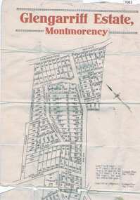
Map, Glengarriff Estate Montmorency, 1938c
... Colour photocopy of subdivision map, on two A3 sheets ...Bordered by Sherbourne Avenue, Calrossie Avenue, Montmorency Station and Price Avenue glengarriff estate montmorency sherbourne avenue montmorency calrossie avenue montmorency price avenue montmorency montmorency station Colour photocopy of subdivision map, on two A3 sheets Glengarriff Estate Montmorency Map T. ...Estate Agent's plan of Glengarriff Estate, Montmorency, covering LPs 11334 and 11451. Bordered by Sherbourne Avenue, Calrossie Avenue, Montmorency Station and Price AvenueColour photocopy of subdivision map, on two A3 sheets glengarriff estate montmorency, sherbourne avenue montmorency, calrossie avenue montmorency, price avenue montmorency, montmorency station -
 City of Kingston
Pamphlet - Colour, W. H. Wood Estate Agent, Subdivisional Land Auction Barker's Estate Cheltenham, 1919
... Handwritten in grey pencil on the subdivision map: a series of numbers on each block possibly indicating the sale price. ...Handwritten in grey pencil on the subdivision map: Roy- joined to subdivision 6 Handwritten in grey pencil on the subdivision map: x on the border between subdivision 17 and 16, and again on the border between subdivision 12 and 11. ...Sales plan for land in the suburb of Cheltenham, along Barker StreetThe developing urban area of Cheltenham within the City of Kingston. This land sale pamphlet illustrates the subdivision of land within the municipality and the changing demographic of the district as new houses are constructed.Colour pamphlet advertising subdivisional land auction of Barker's estate, on Barker Street Cheltenham.Handwritten in grey pencil on the subdivision map: a series of numbers on each block possibly indicating the sale price. Handwritten in grey pencil on the subdivision map: Roy- joined to subdivision 6 Handwritten in grey pencil on the subdivision map: x on the border between subdivision 17 and 16, and again on the border between subdivision 12 and 11.cheltenham, land sales, estate -
 Ringwood and District Historical Society
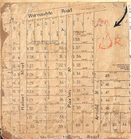
Map, Residential Subdivision Allotment Layout on Mullum Mullum Road, Hobart Street, Paxton Street, Arnold Street and Warrandyte Road, Ringwood, Vic. circa 1920
... One of 3 unrelated land subdivision maps on cardboard backing....One of 3 unrelated land subdivision maps on cardboard backing. Residential Subdivision Allotment Layout on Mullum Mullum Road, Hobart Street, Paxton Street, Arnold Street and Warrandyte Road, Ringwood, Vic. circa 1920. ...One of 3 unrelated land subdivision maps on cardboard backing.H.C. Crouch, Licensed Surveyor, 443 Lt Collins Street, Melbourne. -
 Stawell Historical Society Inc
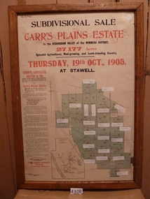
Memorabilia - Realia, 1905
... Carr’s Plains Estate Subdivision Sale Poster with Subdivision Map...Stawell Historical Society Inc 46 Longfield St Stawell grampians Stawell Carr’s Plains Estate Subdivision Sale Poster with Subdivision Map Memorabilia Realia ...Carr’s Plains Estate Subdivision Sale Poster with Subdivision Mapstawell -
 Ringwood and District Historical Society
Document - Folder, Map of Subdivision for auction - Ringwood East, Vic., 1973
... Map of Subdivision for auction - Ringwood East, Vic., 1973....Photocopy of Parish Map showing five residential blocks for sale on Rosedale Crescent, Federal Road and Patterson Street Ringwood East. Map of Subdivision for auction - Ringwood East, Vic., 1973. ...Photocopy of Parish Map showing five residential blocks for sale on Rosedale Crescent, Federal Road and Patterson Street Ringwood East.Accompanying handwritten sales notes researched in 2024 by Richard Carter - Carter Real Estate - "5 lots (heavily filled) auction 14 July 1973. All later sold $4000 each - unknown agent". -
 City of Kingston
Pamphlet - Colour, Moorabbin News Print, Auction = Sale Heather Grove Estate, c. 1914
... Handwritten in grey pencil on subdivision 1: Sold / 20/- Handwritten in grey pencil on subdivision 2: 25/- Handwritten in grey pencil on subdivision 3: 30/- Handwritten in grey pencil on subdivision 4: 110 / 30/- Handwritten in grey pencil on subdivisions 1, 11, 10, 9 and 8: Sold Handwritten in grey pencil beneath 'Heather Grove': 20/- 20/- 20/- 20/- Handwritten in black ink on subdivison 12 and 7: £85 Handwritten in back ink on subdivision 5: £60 Handwritten in back ink on subdivision 6: £65 Handwritten in grey pencil above subdivision map: 1-8-9-10-11 Handwritten in grey pencil above subdivision map: [enclosed in a circle] 12- / £75 Handwritten in grey pencil above subdivision map: [enclosed in a circle] 2 / £85 Handwritten in grey pencil above subdivision map: [enclosed in a circle] 3 / £100 Handwritten in grey pencil above subdivision map: [enclosed in a circle] 4 / £100 Handwritten in grey pencil above subdivision map: [enclosed in a circle] 5 / £60 Handwritten in grey pencil above subdivision map: [enclosed in a circle] 6 / £65 Handwritten in grey pencil above subdivision map: [enclosed in a circle] 7 / £25- Handwritten in grey pencil above subdivision map: [enclosed in a circle] £125 / [indecipherable] Handwritten in grey pencil above subdivision map: 37.00 / 18.10 / 56.80 / 3 / [horizontal line] / 59 8 Handwritten in grey pencil along railway line marking: 21/6 / 12/6 / 13/- / 19/-...Land sales estate Cheltenham Handwritten in grey pencil on subdivision 1: Sold / 20/- Handwritten in grey pencil on subdivision 2: 25/- Handwritten in grey pencil on subdivision 3: 30/- Handwritten in grey pencil on subdivision 4: 110 / 30/- Handwritten in grey pencil on subdivisions 1, 11, 10, 9 and 8: Sold Handwritten in grey pencil beneath 'Heather Grove': 20/- 20/- 20/- 20/- Handwritten in black ink on subdivison 12 and 7: £85 Handwritten in back ink on subdivision 5: £60 Handwritten in back ink on subdivision 6: £65 Handwritten in grey pencil above subdivision map: 1-8-9-10-11 Handwritten in grey pencil above subdivision map: [enclosed in a circle] 12- / £75 Handwritten in grey pencil above subdivision map: [enclosed in a circle] 2 / £85 Handwritten in grey pencil above subdivision map: [enclosed in a circle] 3 / £100 Handwritten in grey pencil above subdivision map: [enclosed in a circle] 4 / £100 Handwritten in grey pencil above subdivision map: [enclosed in a circle] 5 / £60 Handwritten in grey pencil above subdivision map: [enclosed in a circle] 6 / £65 Handwritten in grey pencil above subdivision map: [enclosed in a circle] 7 / £25- Handwritten in grey pencil above subdivision map: [enclosed in a circle] £125 / [indecipherable] Handwritten in grey pencil above subdivision map: 37.00 / 18.10 / 56.80 / 3 / [horizontal line] / 59 8 Handwritten in grey pencil along railway line marking: 21/6 / 12/6 / 13/- / 19/- Colour pamphlet advertising auction of Heather Grove Estate, Cheltenham. ...Sales plan for land in the suburb of Cheltenham, bounded by Tulip Grove and Heather Grove.The developing urban area of Highett within the City of Kingston. This land sale pamphlet illustrates the subdivision of land within the municipality and the changing demographic of the district as new houses are constructed close to infrastructure.Colour pamphlet advertising auction of Heather Grove Estate, Cheltenham. Incorporates a map of the estate bordered by Wickham Road, Railway Parade, Highett Road and Point Nepean Road.Handwritten in grey pencil on subdivision 1: Sold / 20/- Handwritten in grey pencil on subdivision 2: 25/- Handwritten in grey pencil on subdivision 3: 30/- Handwritten in grey pencil on subdivision 4: 110 / 30/- Handwritten in grey pencil on subdivisions 1, 11, 10, 9 and 8: Sold Handwritten in grey pencil beneath 'Heather Grove': 20/- 20/- 20/- 20/- Handwritten in black ink on subdivison 12 and 7: £85 Handwritten in back ink on subdivision 5: £60 Handwritten in back ink on subdivision 6: £65 Handwritten in grey pencil above subdivision map: 1-8-9-10-11 Handwritten in grey pencil above subdivision map: [enclosed in a circle] 12- / £75 Handwritten in grey pencil above subdivision map: [enclosed in a circle] 2 / £85 Handwritten in grey pencil above subdivision map: [enclosed in a circle] 3 / £100 Handwritten in grey pencil above subdivision map: [enclosed in a circle] 4 / £100 Handwritten in grey pencil above subdivision map: [enclosed in a circle] 5 / £60 Handwritten in grey pencil above subdivision map: [enclosed in a circle] 6 / £65 Handwritten in grey pencil above subdivision map: [enclosed in a circle] 7 / £25- Handwritten in grey pencil above subdivision map: [enclosed in a circle] £125 / [indecipherable] Handwritten in grey pencil above subdivision map: 37.00 / 18.10 / 56.80 / 3 / [horizontal line] / 59 8 Handwritten in grey pencil along railway line marking: 21/6 / 12/6 / 13/- / 19/-land sales, estate, cheltenham -
 City of Kingston
Pamphlet - Colour, Arthur Tuckett & Son, Auctioneers and Subdivisional Specialists, Auction of Station Estate, Moorabbin, 1923
... Handwritten in grey pencil top right front page: Station Estate / late [indecipherable] Handwritten in red pencil on subdivision map: x [on majority of properties marked on the map] Handwritten in grey pencil on subdivision map: additional subdivisions drawn in and large lines drawn across the map...Moorabbin Land sales estate Handwritten in grey pencil top right front page: Station Estate / late [indecipherable] Handwritten in red pencil on subdivision map: x [on majority of properties marked on the map] Handwritten in grey pencil on subdivision map: additional subdivisions drawn in and large lines drawn across the map Colour pamphlet advertising an auction of the Station Estate Moorabbin. ...Sales plan for land in the suburb of Moorabbin, bounded by Railway Crescent, South Road, Jasper Road and Pattersons Road.The developing urban area of Moorabbin within the City of Kingston. This land sale pamphlet illustrates the subdivision of land within the municipality and the changing demographic of the district as new houses are constructed.Colour pamphlet advertising an auction of the Station Estate Moorabbin. Incorporates details of the shopping facilities, proximity to the railway line, variety of schools and churches in the area, and a sales plan for home sites and shop fronts. Incorporates a map of the estate bordered by Pattersons Road, Japer Road, South Road and Railway Crescent. Handwritten in grey pencil top right front page: Station Estate / late [indecipherable] Handwritten in red pencil on subdivision map: x [on majority of properties marked on the map] Handwritten in grey pencil on subdivision map: additional subdivisions drawn in and large lines drawn across the mapmoorabbin, land sales, estate -
 Ringwood and District Historical Society
Map, Partially Trimmed Copy of Mountain View Estate Subdivision Advertisement, Ringwood, Vic. - (Undated, circa 1930s)
... Clipped subdivision map on cardboard backing. 22 residential allotments on Daisy Street and Wantirna Road, Ringwood....Phone Central 10907. Clipped subdivision map on cardboard backing. 22 residential allotments on Daisy Street and Wantirna Road, Ringwood. ...Clipped subdivision map on cardboard backing. 22 residential allotments on Daisy Street and Wantirna Road, Ringwood.Auctioneers - Phillips & Nicholson, 59 Swanston Street, Melbourne. Phone Central 10907. -
 City of Kingston
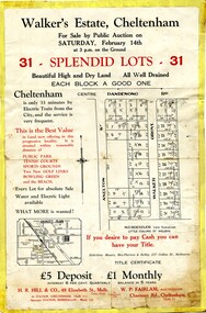
Pamphlet - Colour, H. R. Hill & Co, Walker's Estate, Cheltenham for sale by public auction, c. 1923
... Handwritten in black pen on subdivision map: 'x' written on subdivisions 2, 3, 8-11, 15-17, 19. ...Handwritten in black pen on subdivision map: assumed sale price on subdivisions 1, 4-7, 12-14, 18, 20-31. ...Sales plan for land in the suburb of Cheltenham, encompassing both sides of Walker Grove, a section of Centre Dandenong Rd and Axelton St. The developing urban area of Cheltenham within the City of Kingston. This land sale pamphlet illustrates the subdivision of land within the municipality and the changing demographic of the district as new houses are constructed.Black and white pamphlet advertising for private sale the Station Entrance Estate, Highett. Incorporates a map of the estate bordered by Wickham Road, Railway Parade, Highett Road and Point Nepean Road.Handwritten in black pen on subdivision map: 'x' written on subdivisions 2, 3, 8-11, 15-17, 19. Potentially indicating that these properties did not sell at auction. Handwritten in black pen on subdivision map: assumed sale price on subdivisions 1, 4-7, 12-14, 18, 20-31. land sales, cheltenham, estate -
 Ringwood and District Historical Society
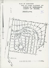
Map - Plan of Subdivision, Part of Crown Allotment 27B Parish of Warrandyte County of Bourke (undated, circa 1970)
... Photocopied subdivision map of 38 residential allotments in Glenvale Road, Cantala Crescent, and Giana Court, north of Kubba Road, Ringwood....Ringwood and District Historical Society 125A Warrandyte Road Ringwood North melbourne Photocopied subdivision map of 38 residential allotments in Glenvale Road, Cantala Crescent, and Giana Court, north of Kubba Road, Ringwood. ...Photocopied subdivision map of 38 residential allotments in Glenvale Road, Cantala Crescent, and Giana Court, north of Kubba Road, Ringwood. -
 Ringwood and District Historical Society
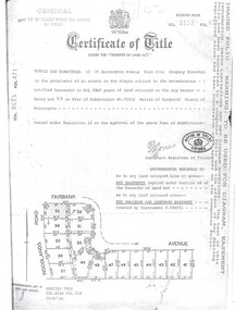
Document, Certificate of Title Vol 8633 Fol 471, Plan of Subdivision No. 73512, Parish of Ringwood, County of Mornington
... A4 Title Search Enquiry printout dated 2003, with Subdivision Map including Fairbank Avenue and Woodlands Road, Heathmont, Vic....A4 Title Search Enquiry printout dated 2003, with Subdivision Map including Fairbank Avenue and Woodlands Road, Heathmont, Vic. ...A4 Title Search Enquiry printout dated 2003, with Subdivision Map including Fairbank Avenue and Woodlands Road, Heathmont, Vic.Issued under Regulation 12 on the approval of the above Plan of Subdivision. Derived from Vol 8618 Fol 718, 26/8/1966. Proprietor - Donald Ian Carmichael of 37 Dorrington Avenue Glen Iris.