
Showing 11 items matching "surrey hills topography"
-
 Surrey Hills Historical Society Collection
Work on paper - Vertical File, Topography
... ...Surrey Hills Topography...No date, no source 4. Surrey Hills Topography 1850 map ...No date, no source 4. Surrey Hills Topography 1850 map Topography Work on paper Vertical File ...Topography 1. 3-4 Igneous Rocks. Pages 53 & 54 photocopy from “Geology of the Melbourne District, Victoria” Bulletin No. 59. Geology Summary Victoria, 1967 2. Black and white photocopy of front cover of “On a limburgite rock occurring as a volcanic plug at Balwyn, near Doncaster” by F Chapman, A.L.S. and A.O. Thiele, 8th June 1911 along with pages 124-136 3. Black and white copy of topographical map of Boroondara. No date, no source 4. Surrey Hills Topography 1850 map geology of the melbourne district, limburgite rock, topographical map, surrey hills topography, igneous rocks -
 Surrey Hills Historical Society Collection
Book, An historical geography of Surrey Hills, 1882-1913, 1979
... surrey hills...geography...topography...Surrey Hills, an eastern suburb of Melbourne. The settlement and growth from a rural district in 1882 to a suburban centre in 1913. surrey hills geography topography j. knipe land use population This thesis presents in a description form, the development of Surrey Hills, an eastern suburb of Melbourne. ...A thesis submitted for the Degree of Bachelor of Arts with Honours. This thesis presents in a description form, the development of Surrey Hills, an eastern suburb of Melbourne. The settlement and growth from a rural district in 1882 to a suburban centre in 1913.This thesis presents in a description form, the development of Surrey Hills, an eastern suburb of Melbourne. The settlement and growth from a rural district in 1882 to a suburban centre in 1913.surrey hills, geography, topography, j. knipe, land use, population -
 Surrey Hills Historical Society Collection
Book, An historical geography of Surrey Hills, 1882-1913, 1979
... surrey hills...geography...topography...Surrey Hills, an eastern suburb of Melbourne. The settlement and growth from a rural district in 1882 to a suburban centre in 1913. surrey hills geography topography j. knipe land use population This thesis presents in a description form, the development of Surrey Hills. ...A thesis submitted for the Degree of Bachelor of Arts with Honours. This thesis presents in a description form, the development of Surrey Hills, an eastern suburb of Melbourne. The settlement and growth from a rural district in 1882 to a suburban centre in 1913.This thesis presents in a description form, the development of Surrey Hills. The settlement and growth from a rural district in 1882 to a suburban centre in 1913.surrey hills, geography, topography, j. knipe, land use, population -
 Surrey Hills Historical Society Collection
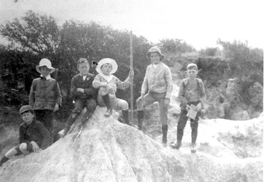
Photograph, Boys who later joined the 1st Surrey Hills scout troop, 1909
... Surrey Hills was the 3rd troop formed in Victoria. Harrison Buchanan was not old enough to join and for a time was the 'troop mascot' as the cubs had not been formed at this time. He later became the troop's 2nd Scoutmaster. Doug Jeffries lived at 12 Vincent Street. Alex Lucas was the son of the draper in Canterbury Road. Our documentation variously gives the date as 1901 or 1909. back creek 1st surrey hills scout troop scouts harrison buchanan alex lucas doug jeffries childhood and youth topography ...1st Surrey Hills was the 3rd troop formed in Victoria. Harrison Buchanan was not old enough to join and for a time was the 'troop mascot' as the cubs had not been formed at this time. He later became the troop's 2nd Scoutmaster. Doug Jeffries lived at 12 Vincent Street. Alex Lucas was the son of the draper in Canterbury Road. Our documentation variously gives the date as 1901 or 1909.Six boys are pictured against a backdrop of scrub in the eroded creek bed, called 'The Alps', of Back Creek opposite Wattle Park. Three of them are identified as: Harrison Buchanan (with the stave), Doug Jeffries on the LHS and Alex Lucas next to him.Black and white photo measuring L 24.5 cm x H 17.4 cmback creek, 1st surrey hills scout troop, scouts, harrison buchanan, alex lucas, doug jeffries, childhood and youth, topography -
 Surrey Hills Historical Society Collection
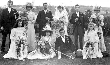
Photograph, Wedding of Annie Beckett and Henry Leigh at Guildford Villa, 21/9/1899, 21/9/1899
... Both the Beckett and Leigh families were significant in the early days of settlement of Surrey Hills. guildford villa weddings wedding dresses annie beckett henry leigh harry leigh bert leigh percy leigh clara beckett mabel beckett elsie beckett arthur leigh winnie leigh topography A B&W photo of bridal party comprised of bride, bridegroom, 3 bridesmaids, 3 male attendants and 2 flowergirls against a largely rural background. ...Taken at Guildford Villa, which has been demolished, at the wedding of Annie Beckett and Henry Leigh. Background view is to the north with Guildford Road across the photo and Monserrat' on Mont Albert Road on the horizon. Identification: Back row - L to R: Bert Leigh, Katie Beckett, Henry (Harry) Leigh, Annie Beckett, Percy Leigh, Clara Beckett. Front row - L to R: Mabel Beckett, Elsie Beckett, Arthur Leigh, Winnie Leigh. The bride was the daughter of Robert Beckett (senior) of Essex Road and the bridegroom was the son of Timothy Leigh, estate agent and architect of Essex Road. Married at the Wesleyan Church.Both the Beckett and Leigh families were significant in the early days of settlement of Surrey Hills.A B&W photo of bridal party comprised of bride, bridegroom, 3 bridesmaids, 3 male attendants and 2 flowergirls against a largely rural background.guildford villa, weddings, wedding dresses, annie beckett, henry leigh, harry leigh, bert leigh, percy leigh, clara beckett, mabel beckett, elsie beckett, arthur leigh, winnie leigh, topography -
 Surrey Hills Historical Society Collection
Photograph, Back Creek (later South Surrey Park), c 1936, 1936
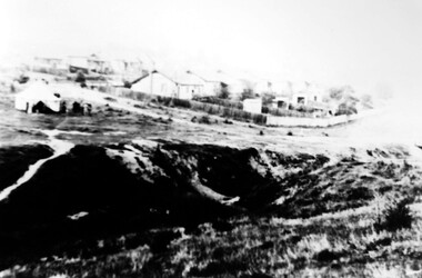
... This photo is significant as it shows the transition from rural to urban land use in Surrey Hills. parks and reserves creeks south surrey park civic occasion official events back creek verdun street 1936 Kleinert family Sir Winston Dugan topography Black and white photo taken in the area later known as South Surrey Park. ...This photo was taken at the opening of the footbridge by Sir Winston Dugan in 1936.South Surrey Park was developed on land which had been the property of the Kleinert family. Their land extended from Union Road to Essex Road. They ran horses, ducks and fowls and Emily Kleinert grew flowers. Alan Holt research: Lot 6 was sold to Martin Klienert by Karl Richter in 1860 together with a portion of another adjacent lot. From 1860-1885 Martin worked it as a market garden leasing some land for grazing when it was not required for gardening. He died in 1898. In a formal document, William declared he was the son of Martin "who purchased land in 1860, died in 1898 and the land has been continually occupied by father and family since. It has been cultivated as a market garden; when not being used for gardening it was let for cultivation and grazing." William died in 1939 and the property passed to his sons Martin and Ernest. The family sold the land to the Camberwell Council in the 1950s.This photo is significant as it shows the transition from rural to urban land use in Surrey Hills.Black and white photo taken in the area later known as South Surrey Park. Back Creek is in the foreground. There is a tent on the LHS and approximately 7 houses which front Verdun Street. Some of their backyards face onto the open space along the creek bed.parks and reserves, creeks, south surrey park, civic occasion, official events, back creek, verdun street, 1936, kleinert family, sir winston dugan, topography -
 Surrey Hills Historical Society Collection
Photograph, Surrey Hills viewed from 'Quamby' at 293 Mont Albert Road, c 1915, 1915
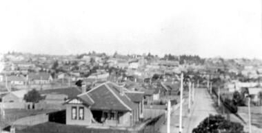
... Ken Sherar was a boy soprano at St Paul's Cathedral; he later moved to Queensland. quamby vincent street edwardian style topography, andrew sherar, isie sherar, connie sherar, dorothy sherar, ken sherar, elsie wappet Black and white photo looking south down Vincent Street from 'Quamby', located at 293 Mont Albert Road, Surrey Hills. ...Quamby was built in 1898. From 1900/1903-1924 it was the home of Andrew Sherar and family. From 1924-1960s it operated as Mosgiel Hospital under the direction of Matron Elizabeth Anderson. Until Box Hill Hospital opened most Surrey Hills children were born at Mosgiel or at Nethercourt Hospital in Wilson Street or later in Union Road when Matron Tank moved her hospital here. Mosgiel Hospital was demolished c 1975 after it was sold by Box Hill Hospital. It was replaced by units. Andrew Sherar was conductor of the Wyclif Church choir for many years and was a member of the Melbourne Liedertafel. Isie Sherar was organist at Wyclif Church and also taught piano in Union Road. Connie Sherar was in the Wyclif choir and married Ernest Swan, an elocutionist and orator. Dorothy Sherar was a pianist and accompanist. Elsie Sherar was also in the Wyclif choir and was a soloist; she later moved to Templestowe. Ken Sherar was a boy soprano at St Paul's Cathedral; he later moved to Queensland.Black and white photo looking south down Vincent Street from 'Quamby', located at 293 Mont Albert Road, Surrey Hills. In the centre foreground is a timber house with 2 chimneys and a tiled hip roof. It has a return veranda and is fenced on 2 sides by paling fences and picket fences on the other two. In the background are many more houses. A road lined with power poles runs from the right foreground to the middle distance.quamby, vincent street, edwardian style, topography, andrew sherar, isie sherar, connie sherar, dorothy sherar, ken sherar, elsie wappet -
 Surrey Hills Historical Society Collection
Photograph, Opening of the footbridge across Back Creek, 1936, 1936
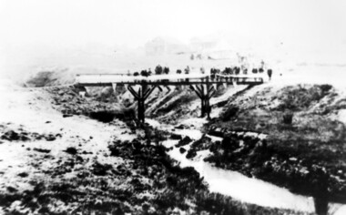
... This photo is significant as it documents the change from rural to urban land use in the area. parks and reserves creeks south surrey park civic occasion official events back creek verdun street footbridges governor of victoria Sir Winston Duggan Surrey Hills Kleinert family (Mr) Karl Richter (Mr) Martin Kleinert topography Black and white photo taken at the opening of the footbridge across Back Creek in the area later known as South Surrey Park. ...This photo was taken at the opening of the footbridge over Back Creek by Sir Winston Dugan, Governor of Victoria, in 1936. He is cutting bunting draped along the bridge rails. South Surrey Park was developed on land which had been the property of the Kleinert family. Their land extended from Union Road to Essex Road. They ran horses, ducks and fowls and Emily Kleinert grew flowers. Alan Holt research: Lot 6 was sold to Martin Klienert by Karl Richter in 1860 together with a portion of another adjacent lot. From 1860-1885 Martin worked it as a market garden leasing some land for grazing when it was not required for gardening. He died in 1898. In a formal document, William declared he was the son of Martin "who purchased land in 1860, died in 1898 and the land has been continually occupied by father and family since. It has been cultivated as a market garden; when not being used for gardening it was let for cultivation and grazing." William died in 1939 and the property passed to his sons Martin and Ernest. The family sold the land to the Camberwell Council in the 1950s.This photo is significant as it documents the change from rural to urban land use in the area.Black and white photo taken at the opening of the footbridge across Back Creek in the area later known as South Surrey Park. Back Creek runs diagonally through the photo with a wooden footbridge prominent. Dignitaries are gathered on the bridge. A tent and houses can just be distinguished in the background.parks and reserves, creeks, south surrey park, civic occasion, official events, back creek, verdun street, footbridges, governor of victoria, sir winston duggan, surrey hills, kleinert family, (mr) karl richter, (mr) martin kleinert, topography -
 Surrey Hills Historical Society Collection
Photograph, Back Creek (later South Surrey Park), c 1936, 1936
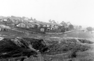
... This photo is significant as it shows the transition from rural to urban land use in Surrey Hills. parks and reserves creeks south surrey park civic occasion official events back creek verdun street 1936 Kleinert family Sir Winston Dugan topography Black and white photo taken in the area later known as South Surrey Park. ...This photo was taken at the opening of the footbridge by Sir Winston Dugan in 1936.South Surrey Park was developed on land which had been the property of the Kleinert family. Their land extended from Union Road to Essex Road. They ran horses, ducks and fowls and Emily Kleinert grew flowers. Alan Holt research: Lot 6 was sold to Martin Klienert by Karl Richter in 1860 together with a portion of another adjacent lot. From 1860-1885 Martin worked it as a market garden leasing some land for grazing when it was not required for gardening. He died in 1898. In a formal document, William declared he was the son of Martin "who purchased land in 1860, died in 1898 and the land has been continually occupied by father and family since. It has been cultivated as a market garden; when not being used for gardening it was let for cultivation and grazing." William died in 1939 and the property passed to his sons Martin and Ernest. The family sold the land to the Camberwell Council in the 1950s.This photo is significant as it shows the transition from rural to urban land use in Surrey Hills.Black and white photo taken in the area later known as South Surrey Park. Back Creek is in the foreground. There is a tent on the LHS and approximately 7 houses which front Verdun Street. Some of their backyards face onto the open space along the creek bed.parks and reserves, creeks, south surrey park, civic occasion, official events, back creek, verdun street, 1936, kleinert family, sir winston dugan, topography -
Surrey Hills Historical Society Collection
Photograph, Opening of the footbridge across Back Creek, 1936, 1936
... This photo is significant as it documents the change from rural to urban land use in the area. parks and reserves creeks south surrey park civic occasion official events back creek verdun street footbridges governor of victoria Sir Winston Duggan Surrey Hills Kleinert family (Mr) Karl Richter (Mr) Martin Kleinert topography Black and white photo taken at the opening of the footbridge across Back Creek in the area later known as South Surrey Park. ...This photo was taken at the opening of the footbridge over Back Creek by Sir Winston Dugan, Governor of Victoria, in 1936. He is cutting bunting draped along the bridge rails. South Surrey Park was developed on land which had been the property of the Kleinert family. Their land extended from Union Road to Essex Road. They ran horses, ducks and fowls and Emily Kleinert grew flowers. Alan Holt research: Lot 6 was sold to Martin Klienert by Karl Richter in 1860 together with a portion of another adjacent lot. From 1860-1885 Martin worked it as a market garden leasing some land for grazing when it was not required for gardening. He died in 1898. In a formal document, William declared he was the son of Martin "who purchased land in 1860, died in 1898 and the land has been continually occupied by father and family since. It has been cultivated as a market garden; when not being used for gardening it was let for cultivation and grazing." William died in 1939 and the property passed to his sons Martin and Ernest. The family sold the land to the Camberwell Council in the 1950s.This photo is significant as it documents the change from rural to urban land use in the area.Black and white photo taken at the opening of the footbridge across Back Creek in the area later known as South Surrey Park. Back Creek runs diagonally through the photo with a wooden footbridge prominent. Dignitaries are gathered on the bridge. A tent and houses can just be distinguished in the background.parks and reserves, creeks, south surrey park, civic occasion, official events, back creek, verdun street, footbridges, governor of victoria, sir winston duggan, surrey hills, kleinert family, (mr) karl richter, (mr) martin kleinert, topography -
 Surrey Hills Historical Society Collection
Book, Surrey Dive Development, Nov. 1986
... Surrey Dive and adjacent areas. It includes topography, site services, buildings, usage of the area including fishing, boating, model boats. surrey dive box hill brick company surrey park shire of nunawading scott and furphy engineers pty ltd box hill An A4 spiral bound report. ...A report on the proposed development of the Surrey Dive and adjacent areas. It includes topography, site services, buildings, usage of the area including fishing, boating, model boats.An A4 spiral bound report.surrey dive, box hill brick company, surrey park, shire of nunawading, scott and furphy engineers pty ltd, box hill
