Showing 39 items matching "surveyor's instrument"
-
 Federation University Historical Collection
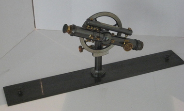
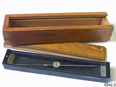
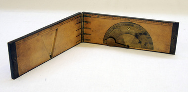
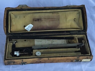
Instrument - Surveyor's Instrument, Boxed Theodolite, c late 1880s
... Surveyor's Instrument...Boxed Theodolite Instrument Surveyor's Instrument W. & L.e. Gurley W. & L.e. Gurley ...According to Max Clarke this item was used by the surveying classes at the Ballarat School of MinesA boxed (timber) theodolite with crossbars and full-length stadia wires. The theodolite can be mounted on a metal straightedge base. The box also contains a magnetic compass with two bubble levels, a plumbing folk, and 4 brass paper clips designed to suit a plan table. On box in black paint "A 1". Inside box lid is manufacturer's label and Stadia measurement zero reference calibration.ballarat school of mines, surveying equipment, gurley, max clarke, theodolite, stadia measurement, calibration, scientific instrument -
 Flagstaff Hill Maritime Museum and Village
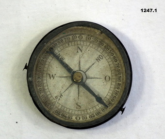
Plane Compass, 1941-1943
... ...surveyor's instrument...It also therefor is of social significance as many Australians served in the Military forces at that time and the item is complete and in very good condition. flagstaff hill warrnambool shipwrecked-coast flagstaff-hill flagstaff-hill-maritime-museum maritime-museum shipwreck-coast flagstaff-hill-maritime-village trough compass navigation instrument surveyor's instrument j w handley artillery australian army trough plane compass world war 2 J.W.H. ...This compass is the type used by an artillery unit of the Australian Military Forces during World War 2 and made by J W Handley. Although having owned the factory site since 1935 at 657 Victoria St J W Handley began to produce various items for the Australian Military forces after purchasing and expanding the factory to 655 Victoria St. It appears that he, or some one else may already have been occupying the site for industrial purposes, such as (Manufacturing, Foundry and Electroplating) since at least 1929. J W Handley Pty Ltd was actively producing items for the Military during the war years, a newspaper article from 1939 shows the factory in production and employing 420 people during 1939. J W Handley after the war moved into producing other non military items including a range of fishing reels. The company ceased trading in 1987 and was deregistered as J W Handley Pty Ltd in 1990.The item demonstrates the industrial capability of Australia at the start of World War 2. This item is actively sort by collectors of Australian Military memorabilia and represents a time in Australian history when the country was at war and the general population was concerned about an invasion from Japanese forces. It also therefor is of social significance as many Australians served in the Military forces at that time and the item is complete and in very good condition.A plane table compass, sometimes referred to as a trough compass, used by surveyors and artillery crew to accurately establish magnetic north. The compass is precision machined of brass material with a long needle to ensure accuracy. The compass scale is marked with a centre zero (for magnetic north) and graduations indicating plus and minus five degrees. The compass is housed in a protective wooden case with a sliding lid. The lid has a brass slide which locks the compass needle during periods when the compass is not in use.J.W.H./V Mark 11 D↑D. Made by J W Handley Richmond Melbourne, Victoria. Serial No 353flagstaff hill, warrnambool, shipwrecked-coast, flagstaff-hill, flagstaff-hill-maritime-museum, maritime-museum, shipwreck-coast, flagstaff-hill-maritime-village, trough compass, navigation instrument, surveyor's instrument, j w handley, artillery, australian army, trough, plane compass, world war 2 -
 Flagstaff Hill Maritime Museum and Village
Plane Compass, 1941-1943
... ...surveyor's instrument...It also therefor is of social significance as many Australians served in the Military forces at that time and the item is complete and in very good condition. flagstaff hill warrnambool shipwrecked-coast flagstaff-hill flagstaff-hill-maritime-museum maritime-museum shipwreck-coast flagstaff-hill-maritime-village trough compass navigation instrument surveyor's instrument j w handley artillery australian army trough plane compass world war 2 J.W.H. ...This compass is the type used by an artillery unit of the Australian Military Forces during World War 2 and made by J W Handley. Although having owned the factory site since 1935 at 657 Victoria St J W Handley began to produce various items for the Australian Military forces after purchasing and expanding the factory to 655 Victoria St. It appears that he, or some one else may already have been occupying the site for industrial purposes, such as (Manufacturing, Foundry and Electroplating) since at least 1929. J W Handley Pty Ltd was actively producing items for the Military during the war years, a newspaper article from 1939 shows the factory in production and employing 420 people during 1939. J W Handley after the war moved into producing other non military items including a range of fishing reels. The company ceased trading in 1987 and was deregistered as J W Handley Pty Ltd in 1990.The item demonstrates the industrial capability of Australia at the start of World War 2. This item is actively sort by collectors of Australian Military memorabilia and represents a time in Australian history when the country was at war and the general population was concerned about an invasion from Japanese forces. It also therefor is of social significance as many Australians served in the Military forces at that time and the item is complete and in very good condition.A plane table compass, sometimes referred to as a trough compass, used by surveyors and artillery crew to accurately establish magnetic north. The compass is precision machined of brass material with a long needle to ensure accuracy. The compass scale is marked with a centre zero (for magnetic north) and graduations indicating plus and minus five degrees. The compass is housed in a protective wooden case with a sliding lid. The lid has a brass slide which locks the compass needle during periods when the compass is not in use.J.W.H./V Mark 11 D↑D. Made by J W Handley Richmond Melbourne, Victoria. Serial number 92 flagstaff hill, warrnambool, shipwrecked-coast, flagstaff-hill, flagstaff-hill-maritime-museum, maritime-museum, shipwreck-coast, flagstaff-hill-maritime-village, trough compass, navigation instrument, surveyor's instrument, j w handley, artillery, australian army, trough, plane compass, world war 2 -
 Flagstaff Hill Maritime Museum and Village
Plane Compass, 1941-1943
... ...surveyor's instrument...It also therefor is of social significance as many Australians served in the Military forces at that time and the item is complete and in very good condition. flagstaff hill warrnambool shipwrecked-coast flagstaff-hill flagstaff-hill-maritime-museum maritime-museum shipwreck-coast flagstaff-hill-maritime-village trough compass navigation instrument surveyor's instrument j w handley artillery australian army trough plane compass world war 2 J.W.H. ...This compass is the type used by an artillery unit of the Australian Military Forces during World War 2 and made by J W Handley. Although having owned the factory site since 1935 at 657 Victoria St J W Handley began to produce various items for the Australian Military forces after purchasing and expanding the factory to 655 Victoria St. It appears that he, or some one else may already have been occupying the site for industrial purposes, such as (Manufacturing, Foundry and Electroplating) since at least 1929. J W Handley Pty Ltd was actively producing items for the Military during the war years, a newspaper article from 1939 shows the factory in production and employing 420 people during 1939. J W Handley after the war moved into producing other non military items including a range of fishing reels. The company ceased trading in 1987 and was deregistered as J W Handley Pty Ltd in 1990.The item demonstrates the industrial capability of Australia at the start of World War 2. This item is actively sort by collectors of Australian Military memorabilia and represents a time in Australian history when the country was at war and the general population was concerned about an invasion from Japanese forces. It also therefor is of social significance as many Australians served in the Military forces at that time and the item is complete and in very good condition.A plane table compass, sometimes referred to as a trough compass, used by surveyors and artillery crew to accurately establish magnetic north. The compass is precision machined of brass material with a long needle to ensure accuracy. The compass scale is marked with a centre zero (for magnetic north) and graduations indicating plus and minus five degrees. The compass is housed in a protective wooden case with a sliding lid. The lid has a brass slide which locks the compass needle during periods when the compass is not in use.J.W.H./V Mark 11 D↑D. Made by J W Handley Richmond Melbourne, Victoria. Serial number 1279flagstaff hill, warrnambool, shipwrecked-coast, flagstaff-hill, flagstaff-hill-maritime-museum, maritime-museum, shipwreck-coast, flagstaff-hill-maritime-village, trough compass, navigation instrument, surveyor's instrument, j w handley, artillery, australian army, trough, plane compass, world war 2 -
 Flagstaff Hill Maritime Museum and Village
Plane Compass, 1941-1943
... ...surveyor's instrument...It also therefor is of social significance as many Australians served in the Military forces at that time and the item is complete and in very good condition. flagstaff hill warrnambool shipwrecked-coast flagstaff-hill flagstaff-hill-maritime-museum maritime-museum shipwreck-coast flagstaff-hill-maritime-village trough compass navigation instrument surveyor's instrument j w handley artillery australian army trough plane compass world war 2 J.W.H. ...This compass is the type used by an artillery unit of the Australian Military Forces during World War 2 and made by J W Handley. Although having owned the factory site since 1935 at 657 Victoria St J W Handley began to produce various items for the Australian Military forces after purchasing and expanding the factory to 655 Victoria St. It appears that he, or some one else may already have been occupying the site for industrial purposes, such as (Manufacturing, Foundry and Electroplating) since at least 1929. J W Handley Pty Ltd was actively producing items for the Military during the war years, a newspaper article from 1939 shows the factory in production and employing 420 people during 1939. J W Handley after the war moved into producing other non military items including a range of fishing reels. The company ceased trading in 1987 and was deregistered as J W Handley Pty Ltd in 1990.The item demonstrates the industrial capability of Australia at the start of World War 2, this item is actively sort by collectors of Australian Military memorabilia and represents a time in Australian history when the country was at war and the general population was concerned about an invasion from Japanese forces. It also therefor is of social significance as many Australians served in the Military forces at that time and the item is complete and in very good condition.A plane table compass, sometimes referred to as a trough compass, used by surveyors and artillery crew to accurately establish magnetic north. The compass is precision machined of brass material with a long needle to ensure accuracy. The compass scale is marked with a centre zero (for magnetic north) and graduations indicating plus and minus five degrees. The compass is housed in a protective wooden case with a sliding lid. The lid has a brass slide which locks the compass needle during periods when the compass is not in use.J.W.H./V Mark 11 D�D. Made by J W Handley Richmond Melbourne, Victoria. Serial number 1333 on boxflagstaff hill, warrnambool, shipwrecked-coast, flagstaff-hill, flagstaff-hill-maritime-museum, maritime-museum, shipwreck-coast, flagstaff-hill-maritime-village, trough compass, navigation instrument, surveyor's instrument, j w handley, artillery, australian army, trough, plane compass, world war 2 -
 Flagstaff Hill Maritime Museum and Village
Theodolite, Troughton & Simms, Mid 19th Century
... ...surveyor's instrument...surveyors and astronomers. It is also significant for its association with nineteenth-century surveying instruments and instrument makers. flagstaff hill warrnambool shipwrecked-coast flagstaff-hill flagstaff-hill-maritime-museum maritime-museum shipwreck-coast flagstaff-hill-maritime-village theodolite t. gaunt & co troughton & simms scientific instrument measuring instrument surveyor's instrument Inscribed on the inner mounting plate,“Specially made in England for T Gaunt & Co Melbourne” and inscribed a little lower “Troughton & Simms London” Theodolite, Vernier repetition theodolite with enclosed horizontal circle (of about 130 mm diameter). ...The theodolite was sold by T. Gaunt & Co. of Melbourne, a manufacturer, importer and retailer of a wide variety of goods including jewellery, clocks and watches, navigational and measuring instruments, dinnerware, glassware and ornaments. Thomas Gaunt photograph was included in an album of security identity portraits of members of the Victorian Court, Centennial International Exhibition, Melbourne, 1888. (See further details below.) History for Troughton & Simms: Edward Troughton & William Simms established a scientific instrument making business in London in 1826. Edward Troughton (1756-1835) had previously had his own scientific instrument business, inherited from his father. His achievement's included a transit telescope for Greenwich Observatory (1816) and the precision surveying instruments for the Ordnance Survey of Britain, Ireland and India. William Simms (1793-1860) had trained as a goldsmith and began to gain work dividing circles on fine astronomical instruments. When William Simms died in 1860, the business was taken over by his son James and nephew William. Troughton & Simms shop in Fleet Street became the hub of the finest scientific instrument made in London, in a period in which there was an expanding demand for precision instruments, for astronomy, surveying and precision measurement. They made instruments for Greenwich Observatory, for imperial surveys and exploring expeditions. When fire destroyed the Houses of Parliament in 1834, the firm was commissioned to create new standard lengths, this required 10 years of testing against the remaining old measurements. Troughton and Simms made several of the main instruments for Melbourne Observatory, including an 18 inch azimuth used of the Geodetic Survey, portable transit instrument (circa 1850), zenith sector (1860), a 4.5 inch equatorial telescope (1862), an 8 inch equatorial telescope (1874) spectroscope (1877) and an 8 inch transit instrument in (1884). While the firm had an excellent reputation for quality the company exasperated many of its customers with delays of years in delivering some instruments. History for Thomas Gaunt: Thomas Ambrose Gaunt (1829 – 1890) was a jeweller, clock maker, and manufacturer of scientific instruments, whose head office and showroom were at 337–339 Bourke Street, Melbourne, Victoria, Australia. Thomas Gaunt established Melbourne's leading watchmaking, optical and jewellery business during the second half of the 19th century. Gaunt arrived in Melbourne in 1852, and by 1858 had established his own business at 14 Little Bourke Street. Around 1869 he moved to new premises in Bourke Street on the corner of Royal Arcade, Gaunt's shop quickly became a Melbourne institution. Gaunt proudly advertised that he was 'The only watch manufacturer in the Australian colonies'. While many watches and clocks may have had Gaunt's name on the dial, few would have been made locally. Gaunt did make some watches for exhibitions, and perhaps a few expensive watches for wealthy individuals. Gaunt's received a telegraph signal from Melbourne Observatory each day to correct his main clock and used this signal to rate and repair ship's chronometers and good quality watches. Thomas Gaunt also developed a department that focused on scientific instrumentation, making thermometers and barometers (from imported glass tubes), telescopes, surveying instruments and microscopes. Significance: With the rapid urban expansion, one of the most important needs of the new colony was to survey and map the landscape of the Australian Colony’s interior. Theodolites, such as this one, made by Troughton and Simms, who were significant scientific instrument makers of the 19th century were instrumental to the colony's surveyors and would have played an important part in their everyday work. This transit theodolite remains of national significance due to its pioneering role in Australian science and its association with Australia's earliest surveyors and astronomers. It is also significant for its association with nineteenth-century surveying instruments and instrument makers. Theodolite, Vernier repetition theodolite with enclosed horizontal circle (of about 130 mm diameter). Vertical circle exposed and somewhat corroded (diameter about 115 mm). Plate level 20" per division. Altitude bubble 20" per division. Horizontal and vertical circle intervals 20". Original (blue/grey) paint. Altitude bubble setting screw disabled. Tribrach allows movement of theodolite by 15 mm inside tribrach (for centering).Inscribed on the inner mounting plate,“Specially made in England for T Gaunt & Co Melbourne” and inscribed a little lower “Troughton & Simms London”flagstaff hill, warrnambool, shipwrecked-coast, flagstaff-hill, flagstaff-hill-maritime-museum, maritime-museum, shipwreck-coast, flagstaff-hill-maritime-village, theodolite, t. gaunt & co, troughton & simms, scientific instrument, measuring instrument, surveyor's instrument -
 Flagstaff Hill Maritime Museum and Village
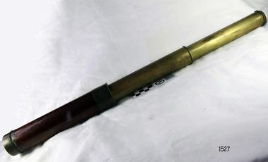
Telescope, 1780-1820
... He went on to describe him as an philosophical instrument maker of optical and mathematical objects, specialising in spectacles, all sorts of surveyors instruments as well as eye glasses of all types. ...He went on to describe him as an philosophical instrument maker of optical and mathematical objects, specialising in spectacles, all sorts of surveyors instruments as well as eye glasses of all types. ...Not much is known about William Rothwell other than he is recorded as working as an optician and scientific instrument maker in Manchester at 277 Deansgate Street from 1780 until 1820. An entry in the “Complete History of the Trades of Manchester” published in 1822, in which the author describes Mr William Rothwell as an intelligent young man who is conversant in several languages. He went on to describe him as an philosophical instrument maker of optical and mathematical objects, specialising in spectacles, all sorts of surveyors instruments as well as eye glasses of all types. At present that is all that is known of William Rothwell other than his products were made to the highest standards of the time. Today his products are now actively sought by collectors and are currently fetching high prices at auction sales overseas. The telescope is a rare item even though not much is known about Rothwell's history his scientific instruments and optical items fetch high prices when they become available as collectors look for rare and well made items from the 18th and 19th centuries. Its completeness and good condition make it a very good addition to the collection at Flagstaff Hill. A three draw military telescope brass with main cylinder section made of wood, main lens is removable for cleaning.Marked "Rothwell, Manchester"flagstaff hill, warrnambool, shipwrecked-coast, flagstaff-hill, flagstaff-hill-maritime-museum, maritime-museum, shipwreck-coast, flagstaff-hill-maritime-village, telescope, william rothwell, scientific instrument, manchester optician, optician -
 Bendigo Military Museum
Photograph - RA Svy Project C4 Aerodist Operation, Eastern & Western Arnhem Land, NT, 1967, 1968
... They are part of the Army Survey Regiment’s Collection. .1) to .2) – Photo, black & white, 1968, unidentified soldier with an opened can of food, possibly bully beef. .3) – Photo, black & white, 15 Aug 1968, aerial view of terrain taken from a helicopter in vicinity of MILINGIMBI SIERRA. .4) – Photo, black & white, 1967, aerial view of an island taken from a helicopter. .5) & .6) – Photo, black & white, 1967, unidentified soldier driving a Haflinger 4x4 Light utility vehicle with trailer. .7) – Photo, black & white, 1967, unidentified surveyors taking vertical measurements with a leveling instrument and staff. .8) – Photo, black & white, 1967, Australian Army Sioux Light Observation Helicopter (LOH) with float removed. .9) to .11) – Photo, black & white, 1967, Australian Army Sioux Light Observation Helicopter (LOH) with floats. .12) – Photo, black & white, 1967, civilian Bell 47G-2 helicopter (Australian Army Sioux LOH equivalent) refuelled. .13) – Photo, black & white, 1967, survey station on coastline surrounded by white plastic aerial photographic identification panels lined with rocks. .14) & .15) – Photo, black & white, 1967, soldier (possibly a signaller from RA Sigs) operating a radio. .16) – Photo, black & white, 1967, Central Comd Fd Svy Unit Operations Section tent, Main Base Gove (Nhulunbuy) L to R: SPR Harry Dunn, WO1 Pat Wood BEM. .17) – Photo, black & white, 1967, Central Comd Fd Svy Unit Operations Section tent, Main Base Gove (Nhulunbuy) L to R: unidentified, WO1 Pat Wood BEM. .18) – Photo, black & white, 1967, Central Comd Fd Svy Unit Operations Section, Main Base Gove (Nhulunbuy), unidentified Australian Army Catering Corps cook preparing meals. .19) – Photo, black & white, 1967, Central Comd Fd Svy Unit Operations Section, Main Base Gove (Nhulunbuy) mess tent in readiness for meals. .20) – Photo, black & white, 1967, Bank of batteries in transit boxes undergoing recharging using generators. .21) – Photo, black & white, 1967, A topographic survey identification plaque set in a concrete block being weighed using a set of scales hanging from slaughtering gallows. .22) – Photo, black & white, 1967, CPL (Geoff or Gary) Larkin operating the remote Aerodist MRC2 ground instrument at Veronica Island, located north of Nhulunbuy. .23) – Photo, black & white, 1967, L to R: CPL (Geoff or Gary) Larkin with unidentified surveyor operate the remote Aerodist MRC2 ground instrument at Venica Island, located north of Nhulunbuy. .24) & .25 – Photo, black & white, 1967, The Aerodist MRC2 Remote antenna. .26) – Photo, black & white, 1967, The Aerodist MRC2 Remote antenna....They are part of the Army Survey Regiment’s Collection. .1) to .2) – Photo, black & white, 1968, unidentified soldier with an opened can of food, possibly bully beef. .3) – Photo, black & white, 15 Aug 1968, aerial view of terrain taken from a helicopter in vicinity of MILINGIMBI SIERRA. .4) – Photo, black & white, 1967, aerial view of an island taken from a helicopter. .5) & .6) – Photo, black & white, 1967, unidentified soldier driving a Haflinger 4x4 Light utility vehicle with trailer. .7) – Photo, black & white, 1967, unidentified surveyors taking vertical measurements with a leveling instrument and staff. .8) – Photo, black & white, 1967, Australian Army Sioux Light Observation Helicopter (LOH) with float removed. .9) to .11) – Photo, black & white, 1967, Australian Army Sioux Light Observation Helicopter (LOH) with floats. .12) – Photo, black & white, 1967, civilian Bell 47G-2 helicopter (Australian Army Sioux LOH equivalent) refuelled. .13) – Photo, black & white, 1967, survey station on coastline surrounded by white plastic aerial photographic identification panels lined with rocks. .14) & .15) – Photo, black & white, 1967, soldier (possibly a signaller from RA Sigs) operating a radio. .16) – Photo, black & white, 1967, Central Comd Fd Svy Unit Operations Section tent, Main Base Gove (Nhulunbuy) L to R: SPR Harry Dunn, WO1 Pat Wood BEM. .17) – Photo, black & white, 1967, Central Comd Fd Svy Unit Operations Section tent, Main Base Gove (Nhulunbuy) L to R: unidentified, WO1 Pat Wood BEM. .18) – Photo, black & white, 1967, Central Comd Fd Svy Unit Operations Section, Main Base Gove (Nhulunbuy), unidentified Australian Army Catering Corps cook preparing meals. .19) – Photo, black & white, 1967, Central Comd Fd Svy Unit Operations Section, Main Base Gove (Nhulunbuy) mess tent in readiness for meals. .20) – Photo, black & white, 1967, Bank of batteries in transit boxes undergoing recharging using generators. .21) – Photo, black & white, 1967, A topographic survey identification plaque set in a concrete block being weighed using a set of scales hanging from slaughtering gallows. .22) – Photo, black & white, 1967, CPL (Geoff or Gary) Larkin operating the remote Aerodist MRC2 ground instrument at Veronica Island, located north of Nhulunbuy. .23) – Photo, black & white, 1967, L to R: CPL (Geoff or Gary) Larkin with unidentified surveyor operate the remote Aerodist MRC2 ground instrument at Venica Island, located north of Nhulunbuy. .24) & .25 – Photo, black & white, 1967, The Aerodist MRC2 Remote antenna. .26) – Photo, black & white, 1967, The Aerodist MRC2 Remote antenna. ...This is a set of 26 photographs of Royal Australian Survey Corps (RA Svy) personnel from Central Comd Fd Svy Unit (Adelaide) on Aerodist survey operation - Project C4 in Eastern Arnhem Land, Northern Territory in 1967 (photos .4P to .26P) and in Western Arnhem Land, Northern Territory in 1968 (photos .1P to .3P). Photos of personnel were taken either at the operations base at Numbulwar or the main base at Gove (Nhulunbuy). RA Svy conducted nineteen Aerodist operations for 12 years from 1964 to 1975. Aerodist MRC2 was a tellurometer-based system adapted for aircraft to accurately measure distances between non-intervisible ground survey stations, using the aircraft as an intermediate station. Lower order geodetic results could be achieved by survey network trilateration. The measured distances between stations formed survey networks from which each station’s latitude and longitude was computed. Aerodist MRC2 was RA Svy’s major horizontal control survey tool for mainly medium scale topographic mapping (scale 1:100,000 Class A being spatially accurate to within 50 metres) in PNG, northern NT, north-west WA, Kalimantan Barat (West) Indonesia, Sumatra Indonesia, Gulf of Carpentaria and Cape York, QLD. In 1967, the Aerodist MRC2 Master equipment was installed in the aircraft featured in this set of photos, Executive Air Services’ (Essendon VIC) Grand Aero Commander VH-EXX. It was the same aircraft type and company contracted to Division of National Mapping for Aerodist MRC2 surveys. From July to October 1967 the aircraft was attached to Central Comd Fd Svy Unit (Adelaide - Major Don Ridge) on Project C4 eastern-Arnhem Land NT, where 317 Aerodist lines measuring 17,300 line miles were successfully completed. This was the most productive Aerodist project thus far. The most common helicopter used by RA Svy up to 1972 was the civilian Bell 47G-2 and the Sioux Light Observation Helicopters (LOH), the Australian Army’s equivalent featured in this photo set. These light observation helicopters had a limiting load carrying capacity of up to about 500 pounds. By comparison, one Aerodist team including two people weighed up to 1,500 pounds. In 1968, after completion of the Kimberley Aerodist Operation project, the Aerodist system in VH-EXX was immediately deployed to western-Arnhem Land NT for Central Comd Fd Svy Unit (Adelaide - Major Don Ridge) to complete the mapping control across northern NT from mid-July to October. The Aerodist MRC2 Remote antenna seen in Photos .24P to .26P is mounted on a 20 foot pole tower. The antenna direction was controlled by wires/ropes to the two arms under the dish at right angles. The antenna elevation could be changed to the vertical for aircraft height checks as seen in photo .25P. Source: Royal Australian Survey Corps – Aerodist Years 1964-1975 by Peter Jensen. Refer to Item 6449.30P for more photos taken during these Aerodist survey operations.This is a set of 26 photographs of Royal Australian Survey Corps (RA Svy) personnel on Aerodist survey operations in Eastern Arnhem Land, Northern Territory in 1967 and Western Arnhem Land, Northern Territory in 1968. The photographs are on 35mm negative film and scanned at 96 dpi. They are part of the Army Survey Regiment’s Collection. .1) to .2) – Photo, black & white, 1968, unidentified soldier with an opened can of food, possibly bully beef. .3) – Photo, black & white, 15 Aug 1968, aerial view of terrain taken from a helicopter in vicinity of MILINGIMBI SIERRA. .4) – Photo, black & white, 1967, aerial view of an island taken from a helicopter. .5) & .6) – Photo, black & white, 1967, unidentified soldier driving a Haflinger 4x4 Light utility vehicle with trailer. .7) – Photo, black & white, 1967, unidentified surveyors taking vertical measurements with a leveling instrument and staff. .8) – Photo, black & white, 1967, Australian Army Sioux Light Observation Helicopter (LOH) with float removed. .9) to .11) – Photo, black & white, 1967, Australian Army Sioux Light Observation Helicopter (LOH) with floats. .12) – Photo, black & white, 1967, civilian Bell 47G-2 helicopter (Australian Army Sioux LOH equivalent) refuelled. .13) – Photo, black & white, 1967, survey station on coastline surrounded by white plastic aerial photographic identification panels lined with rocks. .14) & .15) – Photo, black & white, 1967, soldier (possibly a signaller from RA Sigs) operating a radio. .16) – Photo, black & white, 1967, Central Comd Fd Svy Unit Operations Section tent, Main Base Gove (Nhulunbuy) L to R: SPR Harry Dunn, WO1 Pat Wood BEM. .17) – Photo, black & white, 1967, Central Comd Fd Svy Unit Operations Section tent, Main Base Gove (Nhulunbuy) L to R: unidentified, WO1 Pat Wood BEM. .18) – Photo, black & white, 1967, Central Comd Fd Svy Unit Operations Section, Main Base Gove (Nhulunbuy), unidentified Australian Army Catering Corps cook preparing meals. .19) – Photo, black & white, 1967, Central Comd Fd Svy Unit Operations Section, Main Base Gove (Nhulunbuy) mess tent in readiness for meals. .20) – Photo, black & white, 1967, Bank of batteries in transit boxes undergoing recharging using generators. .21) – Photo, black & white, 1967, A topographic survey identification plaque set in a concrete block being weighed using a set of scales hanging from slaughtering gallows. .22) – Photo, black & white, 1967, CPL (Geoff or Gary) Larkin operating the remote Aerodist MRC2 ground instrument at Veronica Island, located north of Nhulunbuy. .23) – Photo, black & white, 1967, L to R: CPL (Geoff or Gary) Larkin with unidentified surveyor operate the remote Aerodist MRC2 ground instrument at Venica Island, located north of Nhulunbuy. .24) & .25 – Photo, black & white, 1967, The Aerodist MRC2 Remote antenna. .26) – Photo, black & white, 1967, The Aerodist MRC2 Remote antenna.The following photos are annotated in black ink on edge of film negative: .3P – ’15 Aug ’68, 2000’, 1-C18 ’68 MILINGIMBI SIERRA’ .4P – ’U462’ .8P – ‘1-C3/67 Float Removed’ .13P – ‘U477 10-C3/67 .20P - ‘2-C3/67 Bank of Chargers’ .21P - ‘3-C3/67 Gallows & Scales’ .22P - ‘0462 VERONICA ISLAND NT, CPL Larkin’ .23P - ‘0462 VERONICA ISLAND NT’ .24P - ‘4-C3/67 20’ Aerodist Tower’ .25P - ‘5-C3/67 20’ Aerodist Tower’ .26P - ‘6-C3/67 20’ Aerodist Tower’royal australian survey corps, rasvy, army survey regiment, army svy regt, fortuna, asr, aerodist, surveying, central comd fd svy unit -
 Bendigo Military Museum
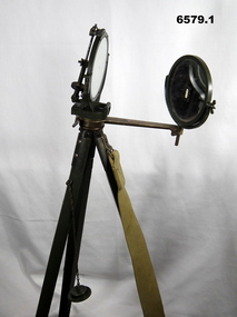
Instrument - Duplex Heliograph Mk V - 1940 with Tripod, LUCO Art Metal Coy Ltd, London, 1940
... instrument was used to communicate between survey stations using Morse code to coordinate their activities. Later when better forms of communication were available, they were used for precise angle alignment where the sunlight reflection from the mirror was targeted between the survey stations to give very accurate results. The MkV was relatively light weight and portable, making it ideal for use in the field. It could be setup and adjusted quickly. The heliograph had an adjustable mirror that could be tilted to reflect sunlight towards a distant receiver. Surveyors...instrument was used to communicate between survey stations using Morse code to coordinate their activities. Later when better forms of communication were available, they were used for precise angle alignment where the sunlight reflection from the mirror was targeted between the survey stations to give very accurate results. The MkV was relatively light weight and portable, making it ideal for use in the field. It could be setup and adjusted quickly. The heliograph had an adjustable mirror that could be tilted to reflect sunlight towards a distant receiver. Surveyors ...The Heliograph MkV is a fascinating piece of historical surveying and communications equipment. It was primarily used for visual signaling by reflecting sunlight with a mirror to send coded messages over long distances. This method was primarily useful in remote areas where other forms of communication were not available. The MkV model, specifically, was widely used by the British Army and other military forces from around 1906 until the mid 1960s. It remained in use with the Australian Army Survey Corps until the mid 1980s. The device typically included a 5 - inch mirror and was often mounted on a tripod for stability. Initially the instrument was used to communicate between survey stations using Morse code to coordinate their activities. Later when better forms of communication were available, they were used for precise angle alignment where the sunlight reflection from the mirror was targeted between the survey stations to give very accurate results. The MkV was relatively light weight and portable, making it ideal for use in the field. It could be setup and adjusted quickly. The heliograph had an adjustable mirror that could be tilted to reflect sunlight towards a distant receiver. Surveyors could align the mirror using a sighting device. Whilst it was primarily used by the Military it was also used in civil surveying particularly in the remote areas of Australia. The British Army Mark V version uses a flat round mirror with a small unsilvered spot in the centre. The sender aligned the heliograph to the target by looking at the reflected target in the mirror and moving their head until the target was hidden by the unsilvered spot. Keeping their head still, they then adjusted the aiming rod so its cross wires bisected the target, they then turned up the sighting vane, which covered the cross wires with a diagram of a cross, and aligned the mirror with the tangent and elevation screws, so the small shadow that was a reflection of the unsilvered spot hole was on the cross target. This indicated that the sunbeam was pointing at the target. If the sun was in front of the sender, its rays were reflected directly from this mirror to the receiving station. If the sun was behind the sender, the sighting rod was replaced by a second mirror, to capture the sunlight and direct it onto the main mirror to reflect it to the receiving station.. 1 Brish Army "Mance" Mk V A253 Heliograph has two 125mm diameter mirrors on a brass arm with targeting attachments. The Instrument is mounted on a three-legged tripod of brass and mahogany with spiked feet, approximately 1.2 metres high. The instrument was made by LUCO Art Metal Co Ltd, London in 1940. .2 A military green metal carrying safety storage case with khaki shoulder strap.A253 stamped on instrumentroyal australian survey corps, rasvy, fortuna, army survey regiment, army svy regt, asr -
 Bendigo Military Museum
Photograph - RASvy Surveyors in the field, c1950s – 1960s
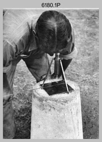
... The surveyor in photo .13P is cutting an identification blaze on a tree using a hammer and chisel. The tellurometer in Photos .14P to .16P was a MRA1 microwave Electronic Distance Measuring instrument (EDM) introduced in 1958. ...The surveyor in photo .13P is cutting an identification blaze on a tree using a hammer and chisel. The tellurometer in Photos .14P to .16P was a MRA1 microwave Electronic Distance Measuring instrument (EDM) introduced in 1958. ...This is a set of 1photographs of surveyors in the field measuring distances using chains, taking observations using theodolites and operating electric distance measurement equipment. They were probably employed in establishing mapping and geodetic control operations or the surveyors may have been in training. The photos were most likely taken in the 1950s and 1960s. Photos .1P to .6P feature personnel setting up geodetic survey chaining equipment to measure distances. The surveyor in Photo .5P is LTCOL Howard Angus Johnson MBE who served from 1936 to 1954. The RA Svy surveyor in photos .7P to .12P were using a theodolite to take angular measurements. They were usually supported by an observer who recording their readings on a booking form. The surveyor in Photo .10P and .11P is LTCOL Jorge Gruszka, who served from 1955 to 1985. He was CO of the Army Survey Regiment from 1982 to 1985. The surveyor in photo .13P is cutting an identification blaze on a tree using a hammer and chisel. The tellurometer in Photos .14P to .16P was a MRA1 microwave Electronic Distance Measuring instrument (EDM) introduced in 1958. It and later models were man-portable systems that improved geodetic survey efficiencies for rapid network extension and densification replacing triangulation with EDM and theodolite traverse sometimes using Bilby Towers to extend line lengths. The surveyor with the slouch hat is Colonel James ‘Jim’ Leslie Stedman, who served from 1941 to 1978. He was Director of Military Survey from 1975 to 1978 and was appointed as Colonel Commandant (honorary appointment, Retd) of the Royal Australian Survey Corps from 1978 to 1983. Jim Stedman is demonstrating EDM equipment.This is a set of 17 photographs of surveyors in the field measuring distances using chains, taking observations using theodolites and operating electric distance measurement (EDM) equipment. c1950s – 1960s. The photographs were printed on photographic paper and are part of the Army Survey Regiment’s Collection. The photographs were scanned at 300 dpi. .1) - Photo, black & white, c1950s, unidentified personnel using geodetic survey chaining equipment. .2) to .4) - Photo, black & white, c1950s, geodetic survey chaining equipment. .5) – Photo, black & white, c1950s, Jim Stedman using geodetic survey chaining equipment to measure distances. .6) - Photo, black & white, c1950s, Unidentified personnel geodetic survey chaining equipment. .7) – Photo, black & white, mounted on card, c1950s. Unidentified surveyor undertaking observations on a coral reef using a theodolite. .8) – Photo, black & white, c1950, unidentified surveyor undertaking observations with a Tavistock theodolite. .9) – Photo, black & white, mounted on green card, c1950s. Unidentified surveyor undertaking observations using a plane table. .10) – Photo, black & white, c1955, Jorge Gruszka undertaking observations with a theodolite. 7/55 Basic Survey Course Balcombe. .11) – Photo, black & white, c1950s, Jorge Gruszka undertaking observations with a theodolite. .12) – Photo, black & white, c1946-1948, unidentified surveyor undertaking observations with a theodolite to gain control for the mapping of the Snowy Mountain Diversion Scheme. .13) – Photo, black & white, c1950s, unidentified surveyor cutting a blaze in a tree. .14) and .15) – Photo, black & white, c1960s, Jim Stedman demonstrating EDM equipment. .16) – Photo, black & white, c1960s, L to R: Jim Stedman (probably) and unidentified surveyor demonstrating EDM equipment. .17) – Photo, black & white, 1956, Operation Cutlass - Surveyors SPR W. Crane and J.A. Campbell undertaking observations with a theodolite in extreme conditions..1P on back - First Order Chaining Equipment .2P on back - First Order Chaining Equipment .3P on back - Full catenary 1800 – 1960 replaced by EDM .4P on back - First Order Chaining Equipment .5P on back - H.A. Johnson, Benambra baseline? 1st Order Chaining .6P on back - Chaining .7P on front - Difficult observing conditions especially when the tide is in. The station is sighted (sic) on a coral reef. .8P on back - Tavistock. .10P on back of duplicate in Photo Folder 14 – George (sic) Gruszka 7/55 Basic Survey Course Balcomme (sic) 1955/56 .14P and .15P on back - Jim Stedman demonstrating early EDM equipment.royal australian survey corps, rasvy, army survey regiment, army svy regt, fortuna, asr, surveying -
 Bendigo Military Museum
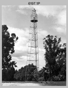
Photograph - Royal Australian Survey Corps Survey Observation Towers, c1950s
... Instruments of Surrender in 1945. Royal Australian Survey Corps RASvy Army Survey Regiment Army Svy Regt Fortuna ASR surveying .1P with paper tag annotated ‘Bilby Tower’ .4P on back – ‘Bilby Tower’. .5P on back – ‘Survey Observing Tower. Observing tower used for angular measurement in flat country. 75’ high – CAPT Ricketts climbing. .6P, .7P on back. ‘1960s?’ This is a set of seven photographs of Royal Australian Survey Corps surveyors ...This is a set of seven photographs of Royal Australian Survey Corps surveyors setting up observation towers in the field and undertaking survey observations during mapping and geodetic control operations. c1950s. Survey observation towers were used mainly to take angular measurements in flat or heavily forested terrain, where height was necessary to achieve observer’s line-of-sight between field survey station. The Bilby Tower seen in photo .5P was erected to a height of 75 feet (23m) above ground level. The use of the Bilby Tower in Topographic Squadron’s field survey operations from 1955 to 1966 is described in page 54 of Valerie Lovejoy’s book 'Mapmakers of Fortuna – A history of the Army Survey Regiment’ ISBN: 0-646-42120-4. CAPT George Ricketts’ period of service was from 1942 to 1976 reaching the rank of LTCOL. It is noted in page 35 of Valerie Lovejoy’s book that then SGT Ricketts hand lettering skills came to the fore from his contribution to the draughting of one of the Japan’s Instruments of Surrender in 1945.This is a set of seven photographs of Royal Australian Survey Corps surveyors setting up observation towers in the field and undertaking survey observations during mapping and geodetic control operations. c1950s. The photographs were printed on photographic paper and are part of the Army Survey Regiment’s Collection. The photographs were scanned at 300 dpi. .1) - Photo, black & white, c1950s, ‘Bilby’ survey observation tower. .2) - Photo, black & white, c1950s, CAPT George Ricketts climbing ‘Bilby’ survey observation tower. .3) - Photo, black & white, c1950s, geodetic survey equipment on ‘Bilby’ survey observation tower. .4) - Photo, black & white, c1950s, two unidentified field surveyors on ‘Bilby’ survey observation tower. .5) - Photo, black & white, c1950s, two unidentified field surveyors, with CAPT Ricketts climbing ‘Bilby’ survey observation tower. .6) - Photo, black & white, c1950s, two unidentified field surveyors undertaking observations on survey observation tower. .7) - Photo, black & white, c1950, two unidentified field surveyors erecting or dismantling a survey observation tower..1P with paper tag annotated ‘Bilby Tower’ .4P on back – ‘Bilby Tower’. .5P on back – ‘Survey Observing Tower. Observing tower used for angular measurement in flat country. 75’ high – CAPT Ricketts climbing. .6P, .7P on back. ‘1960s?’royal australian survey corps, rasvy, army survey regiment, army svy regt, fortuna, asr, surveying -
 Bendigo Military Museum
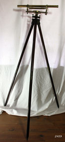
Instrument - Heliograph Mk V Training Aid - circa 1912, 1912
... This instrument was used as a training aid to help teach surveyors at the Royal Australian Survey Corps School of Military Survey. ...This instrument was used as a training aid to help teach surveyors at the Royal Australian Survey Corps School of Military Survey. ...The Heliograph MkV is a fascinating piece of historical surveying and communications equipment. It was primarily used for visual signaling by reflecting sunlight with a mirror to send coded messages over long distances. This method was primarily useful in remote areas where other forms of communication were not available. The MkV model, specifically, was widely used by the British Army and other military forces from around 1906 until the mid 1960s. It remained in use with the Australian Army Survey Corps until the mid 1980s. The device typically included a 5 - inch mirror and was often mounted on a tripod for stability. Initially the instrument was used to communicate between survey stations using Morse code to coordinate their activities. Later when better forms of communication were available they were used for precise angle alignment where the sunlight reflection from the mirror was targeted between the survey stations to give very accurate results. The MkV was relatively light weight and portable, making it ideal for use in the field. It could be setup and adjusted quickly. The heliograph had an adjustable mirror that could be tilted to reflect sunlight towards a distant receiver. Surveyors could align the mirror using a sighting device. Whilst it was primarily used by the Military it was also used in civil surveying particularly in the remote areas of Australia. This instrument was used as a training aid to help teach surveyors at the Royal Australian Survey Corps School of Military Survey. Catalog item No 2009 is a tripod that was used to mount the Heliograph whilst being used for surveying.A Heliograph containing two mirrors with brass surrounds mounted on a wooden board as a Training Aid. Item has additional parts attached to the base board."Heliograph Mk V Training Aid"royal australian survey corps, rasvy, fortuna, army survey regiment, army svy regt, asr -
 Bendigo Military Museum
Equipment - COMPASS, PROTRACTOR, RULER, Est WWI
... Part of the Grinton collection which included hundreds of negatives and developed photos that he took during the War. instruments-measuring surveyors-terrestrial .2) "Veare wood" .3) One inch and centimetre increments. .1) Pocket compass, metal and glass, mirror backed. .2) Protractor-wooden, metal stud and ring. .3) Ruler, wood, in 2 parts. ...The 3 items belonged to Sgt Jack Grinton No 1043, 38th Batt AIF. The ruler was broken by a small piece of shrapnel which then passed through a wallet containing photos. Refer Cat No 1280 for service details. Refer 1317P, 1320P, 1241.22P, 1278.2. Part of the Grinton collection which included hundreds of negatives and developed photos that he took during the War..1) Pocket compass, metal and glass, mirror backed. .2) Protractor-wooden, metal stud and ring. .3) Ruler, wood, in 2 parts..2) "Veare wood" .3) One inch and centimetre increments.instruments-measuring, surveyors-terrestrial -
 Orbost & District Historical Society
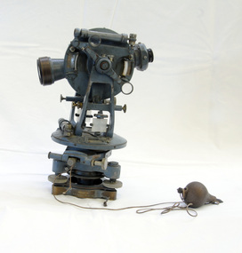
theodolite, first half 20th century
... Theodolites have been used to measure horizontal and vertical angles by surveyors since the 1500s. A theodolite is a precision instrument for measuring angles in the horizontal and vertical planes. ...Orbost & District Historical Society Ruskin Street Orbost gippsland Theodolites have been used to measure horizontal and vertical angles by surveyors since the 1500s. A theodolite is a precision instrument for measuring angles in the horizontal and vertical planes. ...Theodolites have been used to measure horizontal and vertical angles by surveyors since the 1500s. A theodolite is a precision instrument for measuring angles in the horizontal and vertical planes. Theodolites are used mainly for surveying applications, and have been adapted for specialized purposes in fields like meteorology and rocket launch technology. Theodolites, such as this one, were instrumental to early surveyors, and would have played a significant part in their everyday work. The plumb bob was used to set the instrument exactly over a fixed survey marker.This theodolite was made by Troughton and Simms, who were significant scientific instrument makers of the 19th century and early 20th century. In 1782 John Troughton purchased Benjamin Cole's shop in Fleet Street, London enabling him to sell his own signed products. His instrument making business supported several dynasties of Troughtons before becoming Troughton and Simms and later still Cooke Troughton & Simms. This firm was one of the most well respected firms of instrument makers of the 1800s. A grey metal theodolite - probably made of brass. It has movable parts and there is a weight ( a plumb bob) attached with string.Cooke Troughton & Simms Yorke England V012318 Supplied by A. E. Parsons Melbournetheodolite scientific-instruments surveying -
 Orbost & District Historical Society
clinometer rule, mid 19th -earl 20th century
... instrument used in surveying to measure vertical angles. It is used to measure the angle of elevation from the ground in a right-angled triangle. It may have been used by a surveyor...instrument used in surveying to measure vertical angles. It is used to measure the angle of elevation from the ground in a right-angled triangle. It may have been used by a surveyor ...This clinometer, is a hand-held optical scientific instrument used in surveying to measure vertical angles. It is used to measure the angle of elevation from the ground in a right-angled triangle. It may have been used by a surveyor or a forester to measure the height of tall things where you couldn't possibly reach to the top of e.g. flag poles, buildings or trees.This item is an example of an early hand held measuring instrument.. Today the use of electronic sensors is an important component in the design and function of the clinometers.A rectangular wooden folding measuring instrument. the panels are brass framed. Inside is a brass semi-protractorgraduated 90-0-90' with index arm pointeran dwith a graduated edge in inches. Outside is a temperature conversion scale,Troughton & Simms, LONDONscientific-instrument measurement clinometer -
 Montmorency–Eltham RSL Sub Branch
Instrument - Compass, Magnetic
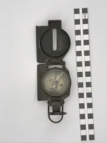
... INSTRUMENT CORP. PLAINFIELD, N.J. DA23-195-AMC-00906(T) (lid open; distance scale on edge - see Media item #5) 1000 2000 3000 1:25000 METERS (underside) RADIOISOTOPE H3 A.E.C. LICENSE NO. 8-5736-3 CONTAIN 75 MS. RADIOACTIVE H3 DO NOT OPEN DISPOSE OF PER AR 755-380 IF FOUND RETURN TO MILITARY AUTHORITY US Magnetic Compass: Made in 1966; used in Vietnam War (Sometimes referred to as a Surveyor's Compass or, less accurately, a prismatic compass). ...US Magnetic Compass: Made in 1966; used in Vietnam War (Sometimes referred to as a Surveyor's Compass or, less accurately, a prismatic compass). When unfolded, the user puts a thumb through the wire loop, holds the lens in front of the eye, and aims the wire 'aiming line' at the required object or direction. While held, the user then looks down towards the dial to read the compass direction. The engraving underneath includes a reference to radioactive material ('H3' – the tritium isotope of Hydrogen) and is used in the luminous paintings that mark principal compass directions.(with lid closed) U.S. COMPASS MAGNETIC FSN 6605-846 7618 UNION INSTRUMENT CORP. PLAINFIELD, N.J. DA23-195-AMC-00906(T) (lid open; distance scale on edge - see Media item #5) 1000 2000 3000 1:25000 METERS (underside) RADIOISOTOPE H3 A.E.C. LICENSE NO. 8-5736-3 CONTAIN 75 MS. RADIOACTIVE H3 DO NOT OPEN DISPOSE OF PER AR 755-380 IF FOUND RETURN TO MILITARY AUTHORITY -
 Stratford and District Historical Society
Theodolite
... The theodolite was possibly in use by Dawson when he laid out St Kilda Road. SURVEYORS INSTRUMENTS "Troughton and Simm's/London" in fine engraving on upper plate. ...This theodolite was used by `Mr Dawson' (presumably William Tennant Dawson c.1820-1873) who `surveyed much of the area around and beyond Stratford'. It was damaged by the fire which burnt the original Roseneath home in 1921, when the Macleods were in residence. (Mrs W.T. Dawson was a Macleod). One little boy aged 3 years was given the job of saving everything on the kitchen table when the fire started at breakfast time. The theodolite was possibly in use by Dawson when he laid out St Kilda Road.This theodoite consists of a bottom plate, which is damaged and has melted metal. This rises to a ball joint, on which is pivoted another plate on which were housed four screws, of which three remain, to adjust the level. Above this is another plate, with compass markings and melted glass."Troughton and Simm's/London" in fine engraving on upper plate.surveyors, instruments -
![Survey metal tape on reel with leather bag. 10 yards in length, the metal chain is subdivided every 10 links [2.2 yards].](/media/collectors/4f729f7e97f83e03086018d1/items/5f87f8fd13cca91a6c1db65a/item-media/615a8287eb51660bb8dc9e31/item-fit-380x285.jpg?cb=6) Queenscliffe Maritime Museum
Queenscliffe Maritime MuseumInstrument - Survey tape on metal reel in leather bag with other articles
... surveyor who worked on surveys up to 1938. He worked in Port Phillip and Queenscliff related surveys [e.g. Western channel, Queenscliff channel]. surveying equipment j p larkin Made by A.E. Parsons surveying instruments ...A surveyors chain is actually a thin steel band on a reel and is used for accurate measurements. This 110 yard [101m] chain is subdivided every 10 links [2.2 yards or 2m]Items belonged to J P Larkin Government marine surveyor who worked on surveys up to 1938. He worked in Port Phillip and Queenscliff related surveys [e.g. Western channel, Queenscliff channel].Survey tape on metal reel in leather bag with other articles: plumb bobs, number pegs, drawing instruments in box and steel punchesMade by A.E. Parsons surveying instruments, 215 Queen Street Melbournesurveying equipment, j p larkin -
 Queenscliffe Maritime Museum
Instrument - Protractor in a flat square wooden box
... instrument used by J P Larkin, government marine surveyor in the 20s and 30s in Port Phillip and queenscliff...Queenscliffe Maritime Museum 2 Wharf St Queenscliff geelong-and-the-bellarine-peninsula instrument used by J P Larkin, government marine surveyor in the 20s and 30s in Port Phillip and queenscliff survey instruments j p larkin Brass drawing circle - a protractor in a flat square wooden box Instrument Protractor in a flat square wooden box ...instrument used by J P Larkin, government marine surveyor in the 20s and 30s in Port Phillip and queenscliffBrass drawing circle - a protractor in a flat square wooden boxsurvey instruments, j p larkin -
 Queenscliffe Maritime Museum
Instrument - Planimeter in leather box
... Larkin, government surveyor, for measuring irregular areas in plans and charts. This type of instrument is still used today and is useful for computing dredging volumes....Larkin, government surveyor, for measuring irregular areas in plans and charts. This type of instrument is still used today and is useful for computing dredging volumes. ...This planimeter in leather box was used by P. J. Larkin, government surveyor, for measuring irregular areas in plans and charts. This type of instrument is still used today and is useful for computing dredging volumes.Surveyor active in the 20s and 30s in Port Phillip and QuennscliffA Planimeter in its own leather box.The Adams Engineering Co. Wellington N.Z. No 8747surveying instruments, p j larkin -
 Queenscliffe Maritime Museum
Instrument - Clinometer in leather case
... Instrument used by J P Larkin, government marine surveyor active in Port Phillip and Queenscliff in the 20s and 30s...Queenscliffe Maritime Museum 2 Wharf St Queenscliff geelong-and-the-bellarine-peninsula Instrument used by J P Larkin, government marine surveyor active in Port Phillip and Queenscliff in the 20s and 30s surveying equipment j p larkin T. ...Instrument used by J P Larkin, government marine surveyor active in Port Phillip and Queenscliff in the 20s and 30sA clinometer in its own leather case.T. Cooke and Sons Ltd London and Yorksurveying equipment, j p larkin -
 Queenscliffe Maritime Museum
Instrument - Surveying Hydrographic measuring Instrument
... Larkin, government surveyor Instrument owned and used by a government marine surveyor named P. ...Survey tape used by P.J. Larkin, government surveyorInstrument owned and used by a government marine surveyor named P. J. Larkin who worked in Melbourne and Geelong in the 1930s.Survey tape in leather pouch about 100 feet long and housed on brass reel.Purton and Littlejohn's patent Wellington 1663surveying instrument, hydrography, larkin jp -
 Queenscliffe Maritime Museum
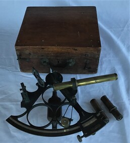
Instrument - Sextant in wooden box
... Queenscliffe Maritime Museum 2 Wharf St Queenscliff geelong-and-the-bellarine-peninsula Sextant used by J P Larken, Government Marine Surveyor The sextant has been the primary position fixing tool of the marine surveyor for 200 years used to measure angles between beacons or points for hydrographic surveys. sextant jp larken marine surveyor On inside box lid; 'A. E. Parson surveying and scientific instrument maker, Queen Street, Melbourne A sextant in its own wooden box. ...Sextant used by J P Larken, Government Marine SurveyorThe sextant has been the primary position fixing tool of the marine surveyor for 200 years used to measure angles between beacons or points for hydrographic surveys. A sextant in its own wooden box.On inside box lid; 'A. E. Parson surveying and scientific instrument maker, Queen Street, Melbournesextant, jp larken, marine surveyor -
 Otway Districts Historical Society
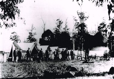
Photograph, Knox Collection, Survey camp for Colac-Beech Forest railway, 1901, 1901
... Surveyors and their assistants came before and during the track laying for the whole distance. colac: beech forest; railways; survey; B/W. Survey camp for the Colac-Beech Forest railway in 1901, showing nine tents, ten men including a cook, survey instruments, and three bicycles. ...Plans for a rail connection between Colac and Beech Forest had been drawn up in 1884 and 1889 but proofed inconclusive because of the enormous cost involved in building a railway in such difficult terrain. Because of the financial depression in the early 1890s such expenditure went of hold. Towards the end of the decade planners recognised that a narrow gauge could be a viable alternative and it was taken up by the community, Parliamentary representatives and the government, although Victorian Railways administration was against the idea. This was overridden. The 1898 Parliament approved a 2 foot 6 inch gauge from Colac to Beech Forest although strict financial limits were set. The route was to be the most direct and the infrastructure the most basic. Construction began in 1900 entailing very steep grades and myriad curves until it finished in 1902. Surveyors and their assistants came before and during the track laying for the whole distance.B/W. Survey camp for the Colac-Beech Forest railway in 1901, showing nine tents, ten men including a cook, survey instruments, and three bicycles. Note the cooking fire on the right.colac: beech forest; railways; survey; -
 Flagstaff Hill Maritime Museum and Village
Instrument - Drainage Level, 1750-1795
... Having one of their early drainage levels in the collection and in extremely good condition is an asset to the Flagstaff collection. flagstaff hill warrnambool shipwrecked-coast flagstaff-hill flagstaff-hill-maritime-museum maritime-museum shipwreck-coast flagstaff-hill-maritime-village george adams fleet street london optical instrument scientific instrument technical instrument surveyors level george adams snr projection microscope "G. ...Adams jnr wrote many elementary scientific works, as well as on the use of mathematical instruments. He often combined in his written works with religious themes and scientific content, often against the prevailing thoughts of the time. According to one popular magazine of the time (Gentleman's Magazine), his works were often accused of "growing errors of materialism, infidelity, and anarchy". He started writing at a young age and developed a love for it, his main interests included math and science, these subjects he often expressed in his written essay's. Notable works from Adams are. An Essay on Electricity, and Magnetism (1784). Essays on the Microscope (1787). An Essay on Vision, briefly explaining the fabric of the eye (1789). Astronomical and Geographical Essays (1790). A Short Dissertation on the Barometer (1790). Geometrical and Graphical Essays, containing a description of the mathematical instruments used in geometry, civil and military surveying, leveling and perspective (1790). Lectures on Natural and Experimental Philosophy, in five volumes (1794).George Adams Sr and Jnr were both notable opticians and scientific instrument makers of the 18th century. Their contribution to scientific innovation and optical development cannot be underestimated. Having one of their early drainage levels in the collection and in extremely good condition is an asset to the Flagstaff collection.Drainage level or optical level. A brass surveying instrument with Achromatic telescope, bubble level and dial fitted to the Tribrach or footplate that has leveling screws. Tripod is wood and brass with adjustable and unscrewable legs (for ease of transportation). Made by "G. Adams Fleet St, London". Used in surveying and building to transfer, measure and/or set horizontal levels."G. Adams - London".flagstaff hill, warrnambool, shipwrecked-coast, flagstaff-hill, flagstaff-hill-maritime-museum, maritime-museum, shipwreck-coast, flagstaff-hill-maritime-village, george adams fleet street london, optical instrument, scientific instrument, technical instrument, surveyors level, george adams snr, projection microscope -
 Flagstaff Hill Maritime Museum and Village
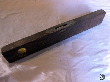
Tool - Spirit level, Early to mid-20th century
... Flagstaff Hill Warrnambool Flagstaff-Hill Flagstaff-Hill-Maritime-Museum Maritime-Museum Shipwreck-coast Flagstaff-Hill-Maritime-Village Hand Tool Spirit Level Carpenders Tool Builders Tool Surveyors Instrument None Spirit level wooden with two windows one of which has a piece of brass sheet metal protecting it. ...The tool is used for establishing a horizontal plane, it consists of a small glass tube containing alcohol or similar liquid and an air bubble. The tube is sealed and fixed horizontally in a wooden or metallic block or frame with a smooth lower surface. The glass tube is slightly bowed, and adjustment to the horizontal is indicated by the movement of the bubble. The device is on a level surface when the bubble is in the middle of the glass tube. The level sensitivity is proportional to the radius of the curvature of the glass. The spirit or bubble level consists of a sealed glass tube containing alcohol and an air bubble. It was invented in 1661 and was first used on telescopes and later on surveying instruments, but it did not become a carpenter's tool until the factory-made models were introduced in the mid-19th century. The circular level, in which a bubble floated under a circular glass to indicate the level in all directions, was invented in 1777. But It lacked the sensitivity of the conventional level.A hand tool that has not changed much since its invention in 1661, this tool is used today and although the materials it is made from have changed it's use has not.Spirit level wooden with two windows one of which has a piece of brass sheet metal protecting it.Noneflagstaff hill, warrnambool, flagstaff-hill, flagstaff-hill-maritime-museum, maritime-museum, shipwreck-coast, flagstaff-hill-maritime-village, hand tool, spirit level, carpenders tool, builders tool, surveyors instrument -
 Federation University Historical Collection
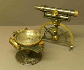
Instrument - Miner's Dial, c early 1900s
... surveyors to determine the direction of underground tunnels and roadways. The inclinometer allowed measurement of the angles at which mine tunnels descend into the ground. mining ballarat school of mines surverying scientific instruments scientific objects A rare miner's dial in a hinged timber box.This surveying instrument consists of a theodolite monsblr on a magnetic compass, which sits on the vertical tapered spigot of a base plate. ...A miner's dial was used by surveyors to determine the direction of underground tunnels and roadways. The inclinometer allowed measurement of the angles at which mine tunnels descend into the ground.A rare miner's dial in a hinged timber box.This surveying instrument consists of a theodolite monsblr on a magnetic compass, which sits on the vertical tapered spigot of a base plate. Fits tripod catalogued item 4133. Inside the box lid is the supplier's label - W. Travill (successor to D. Esdale) of 146 Little Collins Street, Melbournemining, ballarat school of mines, surverying, scientific instruments, scientific objects -
 Federation University Historical Collection
Instrument - Survey Chain, Chesterman, Gunter's Survey Chain
... A Surveyor’s Chain was 66 feet long, and made up of 100 links connected by two rings. A link in measurement includes the two rings at each end. Gunter's Survey Chain Instrument ...Before metric measurement was introduced land was measured in chains and links. The chain was a precision part of a surveyor's equipment. It required frequent calibration, yet needed to be sturdy enough to be dragged through rough terrain for years. A standard survey chain is 66 feet (or 20.117m) long and made up of 100 links. Each link is 7.92 inches (approximately 201mm) long, measured from the inside of the loop. The handles are for tensioning the chain in use, they are not part of the length of the chain. In pre-metric units, there were 80 chains to 1 mile (equals 1.609km) This surveyor’s chain has an 8-inch link pitch, with markers at 10 link intervals. This metal surveyor’s chain (or Gunter's Chain) has an 8-inch link pitch, with markers at 10 link intervals, and handles at either end. A Surveyor’s Chain was 66 feet long, and made up of 100 links connected by two rings. A link in measurement includes the two rings at each end. gunter's chain, survey chain, surveyor s chain, perch, rood, surveying -
 Federation University Historical Collection
Instrument, Chesterman, Surveyors Tape, c1900
... End broken off (approx 5 feet missing). Surveyors Tape. Instrument Chesterman ...Roll of surveyors metal tape with brass handle stamped '100 ft'. Tape marked in 1 inch, 1 foot and 10 foot intervals. Held in roll with leather tie. End broken off (approx 5 feet missing).Brass handle one end only, stamped 100 ft. Tape stamped 'Chesterman Sheffield England'.surveying tape, scientific instrument -
 Federation University Historical Collection
Correspondence, Trower. Still & Keeling, Legal correspondence concerning the death of Frank Wright, 1970/71
... Four pieces of legal correspondence concerning the death of Frank Wright plus an inventory of furniture and musical instruments from chartered surveyors addressed to John Hosier. .... & 4). all have handwritten signatures Four pieces of legal correspondence concerning the death of Frank Wright plus an inventory of furniture and musical instruments from chartered surveyors addressed to John Hosier. ...Frank Wright was a renown resident of Smeaton, where he was born on 2 August 1901. He lived at Laura Villa, and attended Smeaton State School. His father William was a gold miner and his mother's name was Sarah. Their family won many singing and instrumental awards. Frank was tutored by Percy Code and was awarded a gold medal for the highest marks in the ALCM examinations in the British Colonies at the age of seventeen years. He became the Australian Open Cornet Champion by the age of eighteen. A year later, Frank conducted the City of Ballarat Band, and later the Ballarat Soldiers’ Memorial Band. He formed the Frank Wright Frisco Band and Frank Wright and his Coliseum Orchestra. These bands won many South Street awards, and Frank as conductor won many awards in the Australian Band Championship contest. In 1933 Frank Wright sailed to England to conduct the famous St Hilda’s Band and was later appointed Musical Director of the London County Council, where he organized many amazing concerts in parks, in and around the London district. He was made Professor of Brass and Military Band Scoring and conducted at the Guildhall of Music and Drama. Frank was often invited to adjudicate Brass Band Championships around Europe, in Australia, including South Street and in New Zealand. The Frank Wright Medal at the Royal South Street competition is awarded to an individual recognized as making an outstanding contribution to brass music in Australia.Four pieces of legal correspondence concerning the death of Frank Wright plus an inventory of furniture and musical instruments from chartered surveyors addressed to John Hosier. Also included is a telegram from Frank's sister Laura Ritchie, authorising Mr John Hosier to act for the family. The legal correspondence is from Trower, Still & Keeling and the inventory is from E. Copping Joyce & Son.2). Several notes written - one in blue pen, one in black pen and another in pencil. 1a)., 1b)., 2)., 3). & 4). all have handwritten signaturesfrank wright, john hosier, laura ritchie, trower still and keeling