Showing 18 items matching "tailings dam"
-
 Stawell Historical Society Inc
Map, Western Mining Corp / Stawell Joint Venture, Aerial Photo of Wonga Open Cut and Tailings Dam No 2 proposed extension, January 1991
... Aerial Photo of Wonga Open Cut and Tailings Dam No 2 proposed extension...Shows proposed extension No2 Tailings Dam off Lavett Road and proposed Revegetation Corridors ...Stawell Historical Society Inc 46 Longfield St Stawell grampians mining gold map Western Mining Corporation Limited Stawell Joint Venture Shows proposed extension No2 Tailings Dam off Lavett Road and proposed Revegetation Corridors Aerial Photo of Wonga Open Cut and Tailings Dam No 2 proposed extension Map Western Mining Corp / Stawell Joint Venture ...Shows proposed extension No2 Tailings Dam off Lavett Road and proposed Revegetation Corridors Western Mining Corporation Limited Stawell Joint Venturemining, gold, map -
 Stawell Historical Society Inc
Photograph, Magdala cum Moonlight Mine with tailings dam & the Grampians in the background. c1900's
... Magdala cum Moonlight Mine with tailings dam & the Grampians in the background. c1900's...The fire station is on the left in the far distance. with the W S Heal & Sons Coachbuilders Corner of Lazelle and Byrne Street business Magdala cum Moonlight Mine with tailings dam & the Grampians in the background. c1900's Photograph ...Magdala cum Moonlight Mine. Wide view of mine with Grampians Mountains in background.Mine with snow. The Cyanide plant was constructed in Sept 1900 and became the largest in Victoria. Just in front of the large tree a ramp can be seen and a horse and dray going up the ramp. Just below and to the left of the tree the cyanide vats can be seen. On the right is the poppet head of the Magdala and Oriental and North Cross Mine. The fire station is on the left in the far distance. with the W S Heal & Sons Coachbuilders Corner of Lazelle and Byrne Street businessMagdala Cum Moonlight Mine. Herbert's Studio. Stawellstawell gold mining -
 Rutherglen Historical Society
Image, 1937
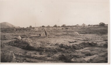
... ...tailings dam...Slum dam is the same as slime dam or tailings dam....Slum dam is the same as slime dam or tailings dam. slum dam gold mining tailings dam mining industry great southern On back of photo: "Slum Dam 1937" "Great Southern where tip is now 1986" Black and white photograph of an area of disturbed ground with buildings, horses and a large mullock heap in the background Image ...Part of a collection relating to the Parkin family. Slum dam is the same as slime dam or tailings dam.Black and white photograph of an area of disturbed ground with buildings, horses and a large mullock heap in the backgroundOn back of photo: "Slum Dam 1937" "Great Southern where tip is now 1986"slum dam, gold mining, tailings dam, mining industry, great southern -
 Bendigo Historical Society Inc.
Newspaper - Kangaroo Flat Gold Mine Collection: Bendigo Mining, 1995, 1999
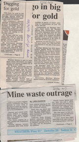
... ...tailings dam...Bendigo Gold Associates have been ordered to 'come back' and 'clean up a potentially dangerous mess' at a gold mine tailings dam in Eaglehawk. ...History House 11 Mackenzie Street Bendigo goldfields Bendigo gold mining Eaglehawk Bendigo Gold Associates tailings dam Doug Buerger Bendigo Mining exploration Two newspaper clippings: a. ...Two newspaper clippings: a. 'Digging for Gold' Bendigo Advertiser, 22nd. February, 1995. Article describes $11 million 'digging and exploration work' being undertaken by Bendigo Mining at Kangaroo Flat, Eaglehawk and other areas of Bendigo. Mr. Doug Buerger stated that his company had 'set a conservative target' to discover up to 100,000 ounces of gold. b. 'Mine Waste Outrage' Bendigo Advertiser, 25th November, 1999. Bendigo Gold Associates have been ordered to 'come back' and 'clean up a potentially dangerous mess' at a gold mine tailings dam in Eaglehawk. bendigo, gold mining, eaglehawk, bendigo gold associates, tailings dam, doug buerger, bendigo mining, exploration -
 Bendigo Historical Society Inc.
Document - FOSTERVILLE GOLD MINE COLLECTION: PROJECT UPGRADE TECHNICAL APPENDICES
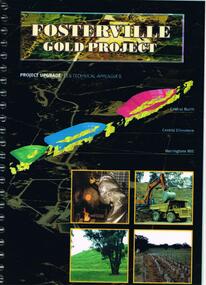
... ...tailings dam site...Topics: hydro geological assessment; surface drainage study, noise emission to residential properties, flora survey, tailings dam site; flora survey Wellesford Forest; Daley's Hill Plant List; diurnal Avifauna Survey - Wellesford Forest; survey of vertebrate fauna - Wellesford Forest; brief summary of fauna - Daley's Hill, Axedale, Aboriginal Archaeological survey; archaeological investigation Fosterville; traffic survey - Fosterville Sulphide Project; traffic report....Topics: hydro geological assessment; surface drainage study, noise emission to residential properties, flora survey, tailings dam site; flora survey Wellesford Forest; Daley's Hill Plant List; diurnal Avifauna Survey - Wellesford Forest; survey of vertebrate fauna - Wellesford Forest; brief summary of fauna - Daley's Hill, Axedale, Aboriginal Archaeological survey; archaeological investigation Fosterville; traffic survey - Fosterville Sulphide Project; traffic report. ...Black cover book, wire binding. Pages in reports numbered individually, overall approx 250 page report. On front: "Fosterville Gold Project' Project upgrade, EES Technical Appendix B. Central North, Central Ellesmere, Harringtons Hill." Page 1 'Perseverance Exploration Pty Limited' Book contains technical appendices. Topics: hydro geological assessment; surface drainage study, noise emission to residential properties, flora survey, tailings dam site; flora survey Wellesford Forest; Daley's Hill Plant List; diurnal Avifauna Survey - Wellesford Forest; survey of vertebrate fauna - Wellesford Forest; brief summary of fauna - Daley's Hill, Axedale, Aboriginal Archaeological survey; archaeological investigation Fosterville; traffic survey - Fosterville Sulphide Project; traffic report.bendigo, mining, fosterville gold mine, hydro geological assessment, surface drainage study, noise emission to residential properties, flora survey, tailings dam site, flora survey wellesford forest, daley's hill plant list, diurnal avifauna survey - wellesford forest, survey of vertebrate fauna - wellesford forest, brief summary of fauna - daley's hill, axedale, aboriginal archaeological survey, archaeological investigation fosterville, traffic survey - fosterville sulphide project, traffic report. -
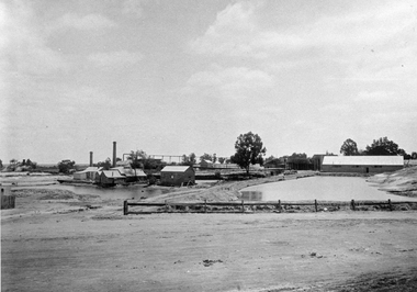 Stawell Historical Society Inc
Photograph, Magdala cum Moonlight Mine with two tailing dams c1900's. Same as 1386-13
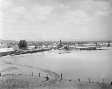
... B/W Photo of Magdala Mine Works in middle distance with two tailing Dams. ...Fence advertises "Drink RoBur Tea" stawell gold mining B/W Photo of Magdala Mine Works in middle distance with two tailing Dams. Magdala cum Moonlight Mine with two tailing dams c1900's. ...Magdala cum Moonlight Mine c1900 Buildings include the mine managers office, change rooms, crushing battery, retorting room, blacksmith shop and cyanide vats. Fence advertises "Drink RoBur Tea"B/W Photo of Magdala Mine Works in middle distance with two tailing Dams. stawell gold mining -
Stawell Historical Society Inc
Map, Stawell Gold Mines, Stawell Township proposed Town zoning showing Special Uses ( Mining) 1998, 1998
... Shows Mining activity Stockpiles Tracks, Plant, Dams, Waste heap, Tailing Dams, Ironbarks...Stawell Historical Society Inc 46 Longfield St Stawell grampians Shows Mining activity Stockpiles Tracks, Plant, Dams, Waste heap, Tailing Dams, Ironbarks Mining Stawell Gold Mines Pty Ltd Date April 1998 Map Printed in Colour with Coloured Legend Stawell Township proposed Town zoning showing Special Uses ( Mining) 1998 Map Stawell Gold Mines ...Shows Mining activity Stockpiles Tracks, Plant, Dams, Waste heap, Tailing Dams, IronbarksMap Printed in Colour with Coloured LegendStawell Gold Mines Pty Ltd Date April 1998mining -
Stawell Historical Society Inc
Map, Stawell Gold Mines, Stawell Township 1995, 1995
... Map shows details of mining activity Stockpiles, Tracks, Plant, Dams,, Waste, Tailing Dams, Ironbarks...Stawell Historical Society Inc 46 Longfield St Stawell grampians Map shows details of mining activity Stockpiles, Tracks, Plant, Dams,, Waste, Tailing Dams, Ironbarks Mining Stawell Gold Mines Pty Ltd Plain Printed Map in Black & White with details of Mining Stawell Township 1995 Map Stawell Gold Mines ...Map shows details of mining activity Stockpiles, Tracks, Plant, Dams,, Waste, Tailing Dams, IronbarksPlain Printed Map in Black & White with details of MiningStawell Gold Mines Pty Ltdmining -
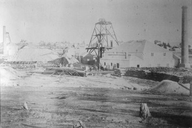 Stawell Historical Society Inc
Photograph, North Cross Reef Mine & Mining Scene 1870 -- B/W Photo & Coloured Painting
... Second taken further back with wood stacks, tailing dam fenced in beyond poppet heads buildings chimmney's smoking. ...Second taken further back with wood stacks, tailing dam fenced in beyond poppet heads buildings chimmney's smoking. ...Mining Scene - North Cross Reef Co.B/W North Cross Reef with buildings, poppet heads, Tailings and wood stack with people. Two colour prints of North cross Reef. One at a different angle to B/W. Second taken further back with wood stacks, tailing dam fenced in beyond poppet heads buildings chimmney's smoking. stawell -
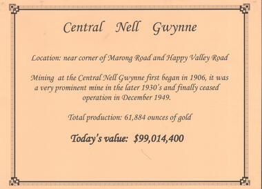 Bendigo Historical Society Inc.
Document - CENTRAL NELL GWYNNE GOLD MINE
... Poppet head and engine room sheds on LH side, trestle way to primary crusher and crushing battery. Tailing dam in immediate foreground. on RH side. ...Poppet head and engine room sheds on LH side, trestle way to primary crusher and crushing battery. Tailing dam in immediate foreground. on RH side. ...Interpretive sign and 4 photos Central Nell Gwynne Gold Mine, used in display. Central Nell Gwynne was located near the corner of Marong Road and Happy Valley Road. Opened in 1906, ceased operation in December 1949. Total production: 61,884 ounces of Gold. Today's Value: $99,014,400. Photos: a. Colour photo, concrete footings at mine site, April 2012. b. Colour photo, Central Nell Gwynne poppet head, April 2012.Poppet head painted white with red trim. Concrete footings in foreround. c. Central Nell Gwynne mine site 1930's. Poppet head and engine room sheds on LH side, trestle way to primary crusher and crushing battery. Tailing dam in immediate foreground. on RH side. Sand heaps in middle foreground. d. Central Nell Gwynne Mine 1930. Underground view, men holding carbide lamps working at 265 level in mine. Large quartz spur formation visible in foreground.bendigo, mining, central nell gwynne -
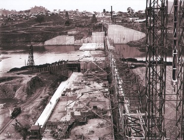 Wodonga & District Historical Society Inc
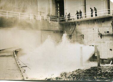
Album - Hume Reservoir Australia Album - View of concrete dam from top of tall tower pillar, August 1927
... View from Top of Tail Tower Pillar - Concrete Dam. This was taken from the top of the Tower described in the preceding photograph looking towards New South Wales. ...View from Top of Tail Tower Pillar - Concrete Dam. This was taken from the top of the Tower described in the preceding photograph looking towards New South Wales. ...This set of photos is from a leather bound album bearing the inscription "HUME RESERVOIR AUSTRALIA" plus 'The Rt. Hon. L. C. M. S. Amery, P. C., M .P.' all inscribed in gold. It was presented to The Rt. Hon. L. C. M. S. Amery, P. C., M. P, Secretary of State for Dominion Affairs on the occasion of his visit to the Hume Reservoir on 2nd November 1927. This album is of local and national significance as it documents the planning and development of the Hume Reservoir up to 1927. It was the largest water reservoir in the British Empire. The album records the pioneering engineering work that went into its construction.DEPARTMENT OF PUBLIC WORKS, N.S.W. RIVER MURRAY WATERS SCHEME. HUME RESERVOIR. 29. View from Top of Tail Tower Pillar - Concrete Dam. This was taken from the top of the Tower described in the preceding photograph looking towards New South Wales. (WHS 00722) First is the part of the spillway being built inside the Coffer Dam, then over the Coffer Dam the submerged portion of the Spillway and outlet sections for the river diversion, beyond that the situation for the hydro-electric turbo passages bounded by the North Wing Wall. The gap may be seen in wing wall for the passage of the belt conveyor and half of the concrete mixer house behind. This gives a general view of the New South Wales Township. The Quarry is on the side of the hill showing up beyond the Township. New South Wales, August 1927.hume reservoir australia, river murray waters scheme, hume reservoir construction -
 Kiewa Valley Historical Society
Photographs – SECV – Clover Power Station
... Clover Power Station and Junction Dam were part of the Kiewa Hydro Electric Scheme constructed by the State Electricity Commission of Victoria SECV; Kiewa Hydro Electric Scheme; Junction Dam; Clover Power Station; Bogong On the back- each photograph has a handwritten reference number starting with K and the date stamped or written Set of black and white photographs taken by the official SECV photographer who gave each photo a number prefixed by K (for Kiewa) K1630- 23 Aug 1944 Clover Power Station K1633- no date Clover Power Station K1683- 10 Oct 1944 Weir K1700- no date Tail boy for Clover Power Station K1710- 11 Oct 1944 Part of aqueduct – Clover K1767- 6 Jan 1945 Switchboard in the power station K1769- 6 Jan 1945 Turbine and shaft K1770- 10 Jan 1945 Houses under construction at Bogong Village K1897- 22 Feb 1945 Equipment in the power station K1808- 22 Feb 1945 Equipment in the power station K1910- 31 May 1945 Top of the turbine and the shaft K1964- 16 Jul 1945 Equipment in the power station K1970- 17 Jul 1945 Bogong Village K1983- 30 Jul 1945 Turbine in power station K1984- 30 Jul 1945 Bogong Village K1989- 2 Aug 1945 Turbines in power station K1990- 2 Aug 1945 Equipment in power station K1991- 2 Aug 1945 Bogong village K2011- 28 Aug 1945 Equipment in power station K2015- 28 Aug 1945 Generators in power station K2016- 28 Aug 1945 Top of the turbine and the shaft K2018- 30 Aug 1945 Spiral casing, the turbine and the shaft Photographs – SECV – Clover Power Station ...The Junction Dam and Clover Dam Power Station, stages of the Kiewa Hydro-Electric Scheme, were needed to meet the increased power demands of the wartime industry in Victoria. Clover added 26 megawatts to the grid. Junction Dam was completed and ready to hold water by September 1943, but was emptied in December 1943 and not filled again until May 1944. Construction of Clover Power Station commenced in July 1941 and both turbines were in service by May 1945.Clover Power Station and Junction Dam were part of the Kiewa Hydro Electric Scheme constructed by the State Electricity Commission of VictoriaSet of black and white photographs taken by the official SECV photographer who gave each photo a number prefixed by K (for Kiewa) K1630- 23 Aug 1944 Clover Power Station K1633- no date Clover Power Station K1683- 10 Oct 1944 Weir K1700- no date Tail boy for Clover Power Station K1710- 11 Oct 1944 Part of aqueduct – Clover K1767- 6 Jan 1945 Switchboard in the power station K1769- 6 Jan 1945 Turbine and shaft K1770- 10 Jan 1945 Houses under construction at Bogong Village K1897- 22 Feb 1945 Equipment in the power station K1808- 22 Feb 1945 Equipment in the power station K1910- 31 May 1945 Top of the turbine and the shaft K1964- 16 Jul 1945 Equipment in the power station K1970- 17 Jul 1945 Bogong Village K1983- 30 Jul 1945 Turbine in power station K1984- 30 Jul 1945 Bogong Village K1989- 2 Aug 1945 Turbines in power station K1990- 2 Aug 1945 Equipment in power station K1991- 2 Aug 1945 Bogong village K2011- 28 Aug 1945 Equipment in power station K2015- 28 Aug 1945 Generators in power station K2016- 28 Aug 1945 Top of the turbine and the shaft K2018- 30 Aug 1945 Spiral casing, the turbine and the shaft On the back- each photograph has a handwritten reference number starting with K and the date stamped or writtensecv; kiewa hydro electric scheme; junction dam; clover power station; bogong -
 Bendigo Historical Society Inc.
Photograph - LONG GULLY HISTORY GROUP COLLECTION: HERCULES/ENERGETIC MINE
... There is also heaps of tailings. In the foreground is a dam, with what looks like ducks/geese on it. ...There is also heaps of tailings. In the foreground is a dam, with what looks like ducks/geese on it. ...Black and white photocopy of the Hercules/Energetic Mine. The photo shows the poppet legs, mine building and brick chimney. There is also heaps of tailings. In the foreground is a dam, with what looks like ducks/geese on it. Written on the back: One of the mines that Sir John Quick worked in. He used to drive a Horse Whim. Hercules / Energetic Mine. Energetic Mine first then amalgamated to H/E.bendigo, history, long gully history group, the long gully history group - hercules/energetic mine, sir john quick -
 Bendigo Historical Society Inc.
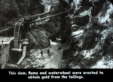
Slide - DIGGERS & MINING. DIGGERS AND MINERS, 1800s
... This dam, flume and waterwheel were erected to obtain gold from the tailings. Picture shows the section of the dam, wheel and waterway. ...This dam, flume and waterwheel were erected to obtain gold from the tailings. Picture shows the section of the dam, wheel and waterway. ...Diggers & Mining. Diggers and Miners. This dam, flume and waterwheel were erected to obtain gold from the tailings. Picture shows the section of the dam, wheel and waterway. Markings: 41 994.5 WAL. Used as a teaching aid. Used as a teaching aid.hanimounteducation, tertiary, goldfields -
 Bendigo Historical Society Inc.
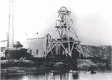
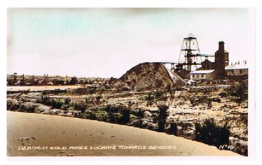
Photograph - DEBORAH GOLD MINES ( NORTH DEBORAH ? )
... Image shows poppet head, chimney, tailings dump. On Lh side of image, dam in centre foreground, On bottom of photo' Deborah Gold Mines looking towards Bendigo, No. 16 '...Image shows poppet head, chimney, tailings dump. On Lh side of image, dam in centre foreground, On bottom of photo' Deborah Gold Mines looking towards Bendigo, No. 16 ' Photograph DEBORAH GOLD MINES ( NORTH DEBORAH ? ...Photo: Deborah Gold Mine ( un-named , possibly North Deborah ). Image shows poppet head, chimney, tailings dump. On Lh side of image, dam in centre foreground, On bottom of photo' Deborah Gold Mines looking towards Bendigo, No. 16 'bendigo, mining, deborah mine, bendigo, gold mines, deborah gold mine, mining -
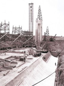
 Stawell Historical Society Inc
Slide, Ian McCann, Constructing the dam wall, 1965
... A Steam Shovel loaing a truck and tailer with rubble part wal up the dam wall....A Steam Shovel loaing a truck and tailer with rubble part wal up the dam wall. Constructing the dam wall Slide Ian McCann ...Colour Slde. A Steam Shovel loaing a truck and tailer with rubble part wal up the dam wall.lake bellfield -
 Wodonga & District Historical Society Inc
Album - Hume Reservoir Australia Album - Work proceeding inside the coffer dam, August 1927
... Tail Tower for the first stages of the work stood on the ground. Part of it is seen erected on the pillar while part of it is still in its original position. To command the concreting of the pillar end of the south wing wall a twin hoist tower of steel construction was erected at the end of the belt conveyor. This hoist is 160 feet high. The belt conveyor will at a later stage be raised for the concreting of the upper portion of the dam...Tail Tower for the first stages of the work stood on the ground. Part of it is seen erected on the pillar while part of it is still in its original position. To command the concreting of the pillar end of the south wing wall a twin hoist tower of steel construction was erected at the end of the belt conveyor. This hoist is 160 feet high. The belt conveyor will at a later stage be raised for the concreting of the upper portion of the dam ...This set of photos is from a leather bound album bearing the inscription "HUME RESERVOIR AUSTRALIA" plus 'The Rt. Hon. L. C. M. S. Amery, P. C., M .P.' all inscribed in gold. It was presented to The Rt. Hon. L. C. M. S. Amery, P. C., M. P, Secretary of State for Dominion Affairs on the occasion of his visit to the Hume Reservoir on 2nd November 1927. This album is of local and national significance as it documents the planning and development of the Hume Reservoir up to 1927. It was the largest water reservoir in the British Empire. The album records the pioneering engineering work that went into its construction.DEPARTMENT OF PUBLIC WORKS, N.S.W. RIVER MURRAY WATERS SCHEME. HUME RESERVOIR. 25. Work proceeding inside the Coffer Dam. This shows the curving downstream face of the Spillway section taking shape, the bottom edge being the line of the contraction joint between the wall and the energy dissipater which has still to be built. Note the steam navvy at the end of the bit of curved work ready to take out the foundations for the energy dissipater. The tall concrete pillar is a portion of the work at the intersection of the main and south wing walls which was built in advance of the rest of the work to accommodate the tail tower of the cableway. The Tail Tower for the first stages of the work stood on the ground. Part of it is seen erected on the pillar while part of it is still in its original position. To command the concreting of the pillar end of the south wing wall a twin hoist tower of steel construction was erected at the end of the belt conveyor. This hoist is 160 feet high. The belt conveyor will at a later stage be raised for the concreting of the upper portion of the dam and the trestles are now being built up for that purpose. A drag line excavator with a 2 cubic yard capacity bucket is at work near the tail tower on the foundations for the south wing wall. New South Wales, August 1927.hume reservoir australia, river murray waters scheme, hume reservoir construction -
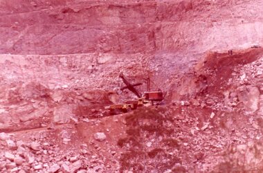
Stawell Historical Society Inc
Photograph, Panorama Moonies No3 Dam 1988
... Moonies No3 Dam Old Tailings ...Stawell Historical Society Inc 46 Longfield St Stawell grampians gold mining Moonies No3 Dam Old Tailings Old Tailings showing Soil Layers in wall of Cutting. 28/11/1988 Panorama Moonies No3 Dam 1988 Photograph ...Old Tailings showing Soil Layers in wall of Cutting. 28/11/1988Moonies No3 Dam Old Tailings gold, mining