Showing 540 items matching "talbot street"
-
 Ballarat Heritage Services
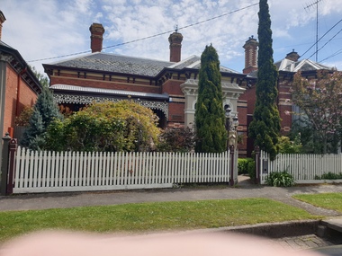
Photograph, Clare Gervasoni, 'Bromley' 6 Talbot Street South, Ballarat Central, 08/10/2021
... 'Bromley' 6 Talbot Street South, Ballarat Central...Photograph of a brick building in Talbot Street South, Ballarat....Ballarat Heritage Services PO Box 2209 Bakery Hill Post Office goldfields Talbot St Ballarat Photograph of a brick building in Talbot Street South, Ballarat. 'Bromley' 6 Talbot Street South, Ballarat Central Photograph Clare Gervasoni ...Photograph of a brick building in Talbot Street South, Ballarat.talbot st ballarat -
 Victorian Apiarists Association
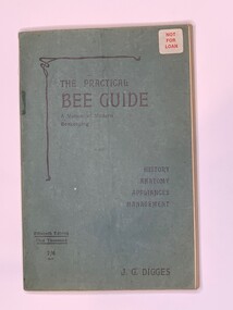
Publication, The Practical Bee Guide (J G Digges) A Manual of Modern Beekeeping 15th Edition, Revised by R O B Manly, May 1, 1949
... 89 Talbot Street, Dublin, Ireland ...Soft Cover Book with mid green cover 255 pages -
 Ballarat Heritage Services
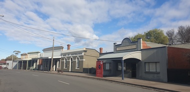
Photograph, Main Street of Talbot, Victoria, 2025, 07/2025
... Main Street of Talbot, Victoria, 2025...It remains to this day and is now the main street of Talbot. (https://www.melbourneplaygrounds.com.au/talbot-heritage-walk accessed 19 July 2025)...It remains to this day and is now the main street of Talbot. (https://www.melbourneplaygrounds.com.au/talbot-heritage-walk accessed 19 July 2025) Talbot Back Creek Gold Mining Colour photograph of shops on Scandinavian Cresent, the Main road of Talbot, Victoria Main Street of Talbot, Victoria, 2025 Photograph ...Throughout the 1840s there had been rumours of gold found in the area, but the evidence was suppressed. The authorities sought to keep the region as a quiet pastoral district, and feared that a gold rush could spark chaos and lawlessness among the largely convict population. In January 1849, former convict Thomas Chapman found a 38 ounce gold nugget in Daisy Hill Creek (7 km from Talbot) while working as a shepherd. He sold it to Melbourne jeweller Charles Brentani in early 1849. This was the first confirmed finding of gold in Victoria and kicked off a minor rush to the region. By late February 1849 thirty to forty trespassers were reported to have gathered at Thomas's former hut seeking gold before being disbanded by a party of police sent from Melbourne. Meanwhile, Thomas fled to Sydney, fearing trouble after his unauthorised sale of the gold that, according to the law of the time, was illegal. The first major rush in the area around current day Talbot occurred in December 1852 when gold was found in Daisy Hill, near what is now Amherst Cemetery (2km west of Talbot). News quickly spread and within a few weeks hundreds of miners from the nearby Castlemaine goldfields had arrived to try their luck. The next major gold find was in 1854 at Kangaroo Flat along Back Creek (1km out of Talbot). By November 1855 it was reported around 6,000 miners had taken up residence in what became known as Back Creek. But, as the gold dwindled, so too did the population and by end-1857 only a few houses remained. In 1859, a group of miners from Norway and Sweden led by Carl Hallen decided to look in an area just outside of Back Creek, previously thought barren of gold as it was un-forested. Their gamble was rewarded, and as the news spread, miners once again flooded into the area. Within 4 months of the Hallan Party's first shaft being dug, there were 50,000 people in the Back Creek region. To cater for this influx, streets were improvised in the area of the diggings - starting with what became known as "Scandinavian Crescent" along the edge of the actual diggings themselves. It remains to this day and is now the main street of Talbot. (https://www.melbourneplaygrounds.com.au/talbot-heritage-walk accessed 19 July 2025)Colour photograph of shops on Scandinavian Cresent, the Main road of Talbot, Victoriatalbot, back creek, gold mining -
 Federation University Historical Collection
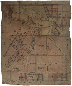
Plan, Plan of Amalgamated Tenements for G.J. Carroll and Party, Ballarat West
... ...Talbot Street...Carroll Webster Street Mill Street Mair Sreet Sturt Street Ballarat Railway ballaarat old cemetery Crewsick Road Gregory Street\Sussex Street Errard Street Raglan Street Lyons Stret Dawson Street Howitt Street ascot street Ripon Street Talbot Street windermere street Plan of Amalgamated Tenements for G.J. ...g.j. carroll and party, carroll, g.j. carroll, webster street, mill street, mair sreet, sturt street, ballarat railway, ballaarat old cemetery, crewsick road, gregory street\sussex street, errard street, raglan street, lyons stret, dawson street, howitt street, ascot street, ripon street, talbot street, windermere street -
 Whitehorse Historical Society Inc.
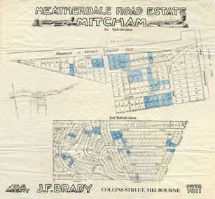
Document, Heatherdale Road Estate, ??
... ...talbot street...land subdivision purches street northcote street linlithgow street denman street fuller street stanley grove dudley street munro street irvine street forster street ferguson street talbot street heatherdale road Plans of 1st and 2nd subdivision of Heatherdale Road estate Plans of 1st and 2nd subdivision of Heatherdale Road estate, Mitcham. ...Plans of 1st and 2nd subdivision of Heatherdale Road estatePlans of 1st and 2nd subdivision of Heatherdale Road estate, Mitcham.Plans of 1st and 2nd subdivision of Heatherdale Road estateland subdivision, purches street, northcote street, linlithgow street, denman street, fuller street, stanley grove, dudley street, munro street, irvine street, forster street, ferguson street, talbot street, heatherdale road -
 Ballarat Heritage Services
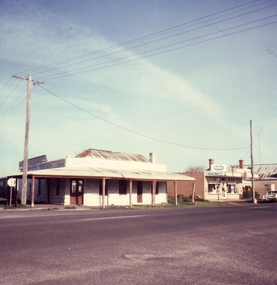
Photograph - Colour Photograph, Talbot Toll Gate, 2004, 2004
... Argyle Street, Talbot, Victoria, Australia ...talbot, tollgate, toll gate -
 Glen Eira Historical Society
Plan - Mount Scopus College, St. Kilda East
... Street... Talbot Avenue...Kilda East City of Caulfield Mayfield Street Talbot Avenue Floyd Jeff Building Permits Planning Act Shaw House M.M.B.W. ...A copy of the amended Planning brief for the development of Mount Scopus College dated 24/10/1982. It includes a covering letter listing the amendments. The planning brief describes the school’s facilities, classrooms, playground and the planned development of the school. It includes a site plan and an architect’s illustration of the proposed development.mount scopus college, st. kilda east, city of caulfield, mayfield street, talbot avenue, floyd jeff, building permits, planning act, shaw house, m.m.b.w. planning scheme, classrooms, kindergarten, playgrounds, library, multipurpose hall, car parking, students, teachers, staff, secondary school, primary school, synagogue, architects, syman justin and bialek, site plan, hall, building development, education department, town and country planning board, brick, zoning, traffic, property, landscape planning, planting, fence -
 Bendigo Historical Society Inc.
Document - STRAUCH COLLECTION: SUBSCRIPTION LIST FOR TALBOT GERMAN CLUB 1877 - 1887
... This association had it's clubhouse at Ballarat Street, Talbot...History House 11 Mackenzie Street Bendigo goldfields This association had it's clubhouse at Ballarat Street, Talbot CLUBS Social german German-Talbot-names Lists written in German showing names and payments for subscriptions to the Talbot German Club 1877 - 1887. ...This association had it's clubhouse at Ballarat Street, TalbotLists written in German showing names and payments for subscriptions to the Talbot German Club 1877 - 1887.clubs, social, german, german-talbot-names -
 Ballarat Tramway Museum
Slide - 27 mm sq slide/s - set of 3, Lilian Butler, Sturt St and Ripon Sts, 1971
... Set of 3 Hanimex slides - what cardboard mounts: 1 - View Point line junction at Ripon St, looking north west with short tram stop pole and Ampol service station sign on the right. 2 - Water column North West corner of Sturt Street and Talbot Street (opposite the Fire Station). Column long gone. ...Talbot St. Ballarat Tramways trams Sturt St View Point Ripon St Tram Stops Set of 3 Hanimex slides - what cardboard mounts: 1 - View Point line junction at Ripon St, looking north west with short tram stop pole and Ampol service station sign on the right. 2 - Water column North West corner of Sturt Street and Talbot Street (opposite the Fire Station). ...Yields information about Ripon St, Talbot St.Set of 3 Hanimex slides - what cardboard mounts: 1 - View Point line junction at Ripon St, looking north west with short tram stop pole and Ampol service station sign on the right. 2 - Water column North West corner of Sturt Street and Talbot Street (opposite the Fire Station). Column long gone. (Advised by Neville Britton 26/9/2016 - by e-mail) 3 - looking west - South side of Sturt St. Photo from the collection of Lilian Butlerballarat, tramways, trams, sturt st, view point, ripon st, tram stops -
 Clunes Museum
Photograph - PHOTOGRAPH BLUE ROCK HOTEL
... COLOURED PHOTOGRAPH OF BLUE ROCK HOTEL SITUATED ON CORNER SUBURBAN STREET AND TALBOT ROAD, CLUNES. ADJACENT TO WHAT IS NOW (2025) THE TOP SHOP...IT WAS USED AS DELI/TAKE AWAY SHOP IN THE NINETEEN-FIFTIES. local history photography photographs hotels all nation's blue rock COLOURED PHOTOGRAPH OF BLUE ROCK HOTEL SITUATED ON CORNER SUBURBAN STREET AND TALBOT ROAD, CLUNES. ADJACENT TO WHAT IS NOW (2025) THE TOP SHOP Photograph PHOTOGRAPH BLUE ROCK HOTEL ...THE BLUE ROCK HOTEL BUILDING WAS DEMOLISHED AFTER A FIRE. IT WAS USED AS DELI/TAKE AWAY SHOP IN THE NINETEEN-FIFTIES.COLOURED PHOTOGRAPH OF BLUE ROCK HOTEL SITUATED ON CORNER SUBURBAN STREET AND TALBOT ROAD, CLUNES. ADJACENT TO WHAT IS NOW (2025) THE TOP SHOPlocal history, photography, photographs, hotels, all nation's, blue rock -
 Eltham District Historical Society Inc
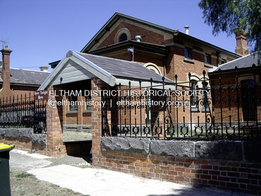
Photograph - Digital Photograph, Russell Yeoman, Talbot Jusice Precinct, 2005
... Located at 9 Camp Street, Talbot. In more recent times was the Talbot Observatory (now closed)...Located at 9 Camp Street, Talbot. In more recent times was the Talbot Observatory (now closed) Russell Yeoman Collection Talbot Justice Precinct Talbot Observatory Born digital Some paper photo prints Talbot Jusice Precinct Photograph Digital Photograph Russell Yeoman ...Comparitive example from the mid 1880s with the Eltham Justice Precinct of 1859/1860. Located at 9 Camp Street, Talbot. In more recent times was the Talbot Observatory (now closed)russell yeoman collection, talbot justice precinct, talbot observatory -
 Clunes Museum
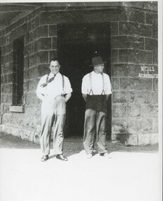
Photograph
... "BLUE ROCK" HOTEL WAS SITUATED ON CORNER OF SUBURBAN STREET AND TALBOT ROAD, CLUNES. JACK WALLACE WAS SON OF THE LICENCEE....Clunes Museum 36 Fraser Street enter building through Collins Place Clunes goldfields "BLUE ROCK" HOTEL WAS SITUATED ON CORNER OF SUBURBAN STREET AND TALBOT ROAD, CLUNES. JACK WALLACE WAS SON OF THE LICENCEE. local history photographs hotels BLACK AND WHITE PHOTOCOPY OF BILL GILBERT AND JACK WALLACE STANDING IN FRONT OF ALL NATIONS HOTEL, ("BLUE ROCK") Photograph PHOTOGRAPH ..."BLUE ROCK" HOTEL WAS SITUATED ON CORNER OF SUBURBAN STREET AND TALBOT ROAD, CLUNES. JACK WALLACE WAS SON OF THE LICENCEE.BLACK AND WHITE PHOTOCOPY OF BILL GILBERT AND JACK WALLACE STANDING IN FRONT OF ALL NATIONS HOTEL, ("BLUE ROCK")local history, photographs, hotels -
 Clunes Museum
Photograph
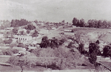
... PHOTOCOPY OF PHOTOGRAPH OF CLUNES LANDSCAPE TAKEN FROM SCENIC ROAD, BRIDGE IN RIGHT FOREGROUND, ANZ BANK IN CENTRE GROUND, TEMPLETON STREET AND TALBOT MINE CENTRE RIGHT [CENTRAL CLUNES MINE?]...Clunes Museum 36 Fraser Street enter building through Collins Place Clunes goldfields local history photography photographs clunes landscape + buildings PHOTOCOPY OF PHOTOGRAPH OF CLUNES LANDSCAPE TAKEN FROM SCENIC ROAD, BRIDGE IN RIGHT FOREGROUND, ANZ BANK IN CENTRE GROUND, TEMPLETON STREET AND TALBOT MINE CENTRE RIGHT [CENTRAL CLUNES MINE?] ...PHOTOCOPY OF PHOTOGRAPH OF CLUNES LANDSCAPE TAKEN FROM SCENIC ROAD, BRIDGE IN RIGHT FOREGROUND, ANZ BANK IN CENTRE GROUND, TEMPLETON STREET AND TALBOT MINE CENTRE RIGHT [CENTRAL CLUNES MINE?]local history, photography, photographs, clunes landscape + buildings -
 Clunes Museum
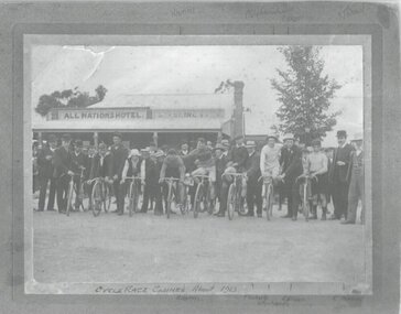
Photograph, CYCLE RACE
... PHOTOGRAPH TAKEN IN FRONT OF ALL NATIONS HOTEL CR. TALBOT ROAD AND SUBURBAN STREET, CLUNES....Clunes Museum 36 Fraser Street enter building through Collins Place Clunes goldfields START OF CYCLE RACE CLUNES. H. HARRIS, F. ROBERTS,W. RICHARDS, E. OLSON, R.THOMAS. PHOTOGRAPH TAKEN IN FRONT OF ALL NATIONS HOTEL CR. TALBOT ...START OF CYCLE RACE CLUNES. H. HARRIS, F. ROBERTS,W. RICHARDS, E. OLSON, R.THOMAS. PHOTOGRAPH TAKEN IN FRONT OF ALL NATIONS HOTEL CR. TALBOT ROAD AND SUBURBAN STREET, CLUNES.PHOTOGRAPH OF START CYCLE RACE ABOUT 1912 OR 1913 PICTURE TAKEN IN FRONT OF ALL NATIONS HOTELCYCLE RACE CLUNES ABOUT 1913 NAMES WRITTEN ON OF PARTICIPANTS. H HARRIS , F ROBERTS, W RICHARDS, E OLSEN R THOMAS,photography, sport, bicycle, bycicle race 1912 or 1913 -
 Ringwood and District Historical Society
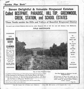
Pamphlet, Land Sale Brochure Titled Eureka Plan Book - Seven Delightful & Valuable Ringwood Estates - circa 1925
... Street. Plan of Goodluck Estate, Clarinda, includes Talbot Avenue, Good Street, Luck Street, and Centre Road in locality plan between Oakleigh and Clayton Railway Stations....Street. Plan of Goodluck Estate, Clarinda, includes Talbot Avenue, Good Street, Luck Street, and Centre Road in locality plan between Oakleigh and Clayton Railway Stations. ...Twenty page land sale brochure including photographs, subdivision features and local facilities. Additional flyer with conditions of sale and prices for estate blocks.Seven delightful and valuable Ringwood Estates called Bestpart, Paradise, Hill Top, Greenwood, Creek, Station, and School Estates. These nestle amidst the hills and valleys of beautiful Ringwood district. Also Goodluck Estate at Clarinda. Pamphlet marked as being From Mr. Farmer, No. 5 Flinders Court, Melbourne. Phone 988, 989 Central, or 55 Ringwood after 7 p.m. Plan of Ringwood School Estate includes William Street (later Kendall Street), Greenwood Avenue, Alton Street and Locke Street. Plan of Bestpart Estate, Ringwood, includes Bedford Road, Wilana Street, Greenwood Avenue, Caroline Street, Henry Street and Haig Street. Plan of Ringwood Station Estate includes Pitt Street, Bedford Road, Greenwood Avenue, Station Street, William Street (later Kendall Street, James Street, Wantirna Road, Caroline Street, Henry Street, Ellison Street and Haig Street. Plan of Geenwood Estate, Ringwood, includes Prussian Road (later Geenwood Avenue). Plan of Paradise Estate, Ringwood, includes Canterbury Road, Dandenong Road (Wantirna Road), Luck Street and Paradise Road. Plan of Creek Estate, Ringwood, includes Dandenong Creek, Wantirna Road and Gordon Crescent. Plan of Hill Top Estate, Ringwood (later Heathmont area), includes Heathmont Railway Station, Heathmont Road, Balfour Avenue, Lilian Street, Edith Street, Edna Street and Great Ryrie Street. Plan of Goodluck Estate, Clarinda, includes Talbot Avenue, Good Street, Luck Street, and Centre Road in locality plan between Oakleigh and Clayton Railway Stations. -
 Warrnambool and District Historical Society Inc.
Badges, TOC-H Badges x 3
... Warrnambool and District Historical Society Inc. 2 Gilles Street (south of Merri St) Warrnambool great-ocean-road TOC H was founded as a Christian organisation during the First World War in Belgium in 1915. Talbot ...TOC H was founded as a Christian organisation during the First World War in Belgium in 1915. Talbot House was a venue for respite from the war for soldiers and civilians. During the 1920s TOC H spread around the world especially to Commonwealth countries. In 1923 the Governor General of Australia wrote to The Reverend "Tubby" Clayton indicating that he and Lady Forster wished to endow a TOC H lamp, the symbol of TOC H in memory of their two sons who were killed in the war. The lamp symbol is a replica of the lamp used to provide light to early Christians who sought refuge in the catacombs of Rome. The cross of Lorraine is an indicator of its origins in the Ypres salient.The lamp is a symbol of an ongoing commitment of TOC H to spread light wherever it may be required. These badges are maintained as mementos of the Warrnambool branch of TOC H which operated from a sandstone building in Koroit Street Warrnambool. It was active during the middle decades of the 20th Century .1 Octagonal metal and enamel badge featuring a gold coloured oil lamp and cross on a green luminous background with rays emanating from the lamp. The badge has a gold edging. The reverse has a pin clip and text .2 and .3 Octagonal metal and enamel lapel badge featuring a gold coloured oil lamp and cross on a royal blue background. The badge has a gold edging. The reverse has a horseshoe shaped device to allow the badge to be secured in the buttonhole of a jacket. .1Indecipherable .2 Stokes and Sons Melbourne .3 2849toc h, tubby clayton, lord forster -
 Bendigo Military Museum
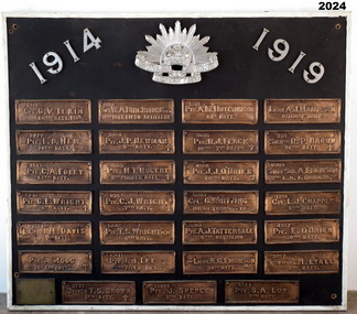
Honour Board - EAST BENDIGO PRIMARY SCHOOL HONOUR BOARD WW1, original plaques, post WW1
... Street, Bendigo). 14. 60999 PTE. J. SPENCE 5th BATT. (John Spence born in Bendigo. RTA. NOK Father’s address: 99 Talbot St, Brunswick) 15. 5127 PTE. ...Street, Bendigo). 14. 60999 PTE. J. SPENCE 5th BATT. (John Spence born in Bendigo. RTA. NOK Father’s address: 99 Talbot St, Brunswick) 15. 5127 PTE. ...The Bendigo East Primary School was opened in 1915. In 1916 it was decided to plant an ANZAC Avenue of trees and this was completed on 16 June 1916. The plaques were placed after WW1. The school was closed in 1998 and the plaques were relocated to the nearby White Hills Secondary College in Napier Street on this board. In the early 2000's the Honour Board was donated to what is now called the Bendigo Military Museum. One hundred years after planting, later in 2016 the trees were removed in controversial circumstances. On the board 8 never returned, there is 1 x "DCM" winner, 1 x "MC" winner and 1 x "MM" winner. There are 3 x Wright Brothers of which 2 never returned. The plaque states that the soldiers attended the school which is obvious they could not have due to the opening date. The following Heritage report suggests that the names were of individual soldiers who lived in the area. EXTRACT FROM HERITAGE COUNCIL VICTORIA 2016 SUBMISSIONS HEARING “The Bendigo East School (‘the school’) was officially opened by Mr Frank Tate, Director of Education, on 7 April 1916. Approximately two months later, on 16 June 1916, Arbor Day was celebrated at the school with the planting of an ‘Anzac Avenue’ along a path from the front gate on Strickland Road (‘the pathway’) to commemorate the landing of soldiers at Gallipoli. The school’s ‘Anzac Avenue’ was one of an estimated 37 known to have been planted by school children throughout Victoria during mid-1916 as part of a program led by the Education Department, which included a recommendation to schools on 18 May 1916 that commemorative avenues be planted (‘the 1916 plantings recommendation’). At around this time, avenues of honour were also planted across Victoria to commemorate fallen WWI soldiers (‘the wider commemorative plantings phenomenon’). There were other commemorative plantings at the Place away from the pathway (‘the other commemorative plantings’). Anzac Day was celebrated at the Place in the years subsequent to 1916 and on 11 December 1920 the school’s ‘Anzac Avenue’ was officially opened. Embossed copper plates, mounted on wood, were fixed in front of the trees in memory of individual soldiers from the district who had seen active service in WWI. There is evidence that as many as 32 plaques may have been made and affixed (‘the name plaques’). Plaques were removed from their locations at some stage before 1964, mounted on a board and displayed in the school building. These are now located and displayed at Bendigo Sub - Branch of the Returned Services League.” EAST BENDIGO HONOUR BOARD – COPPER PLAQUES (27 PLAQUES in total). 1. 2441 CPL G.V. LE KIM 60th BATT. M.M. (George Vincent LEE-KIM, born in Bendigo, Awarded Military Medal. RTA. NOK Father’s Address: C/- Strickland Rd, Bendigo). 2. 3821 PTE. E.B. HEM 20TH BATT. (Edward Bert Hem born in Bendigo. RTA. NOK Mother’s address: White Hills Post Office). 3. 3513 PTE. C.A. FOLEY 57th BATT. (Charles Albert Foley born in Bendigo. RTA. NOK Father’s address: Wilkie Street, Bendigo). 4. 5241 PTE. G. E. WRIGHT 6th BATT. † (George Edwin Wright born in Bendigo. KIA 8/12/1916. NOK Father’s address: 55 Charleston Rd. Bendigo). 5. 2663 L.CPL. N. E. DAVIS 60th BATT. (Norman Edward Davis born in Footscray. RTA. NOK Mother’s address: 193 Strickland Rd. Bendigo). 6. PTE. A. MOOG 16-6th BATT. † (5143 Adolph Moog born in Bendigo. Died of wounds received in action 8/12/1916, NOK Father’s address: Municipal Yards, Bendigo.) 7. 6515 SGT. W.A. BIRCHMORE DCM 11TH BATT. FIELD ARTILLERY (William Albert Birchmore born in Bendigo. Awarded DCM. RTA. NOK Mother’s address: Butler Street, California Gully) 8. 3924 PTE. J.P. NEWMAN 5TH BATT. † (392 (NAA) James Pausey Newman. Born in Bendigo. KIA 25/7/1916. NOK Father’s address Strickland Road, Bendigo) 9. 4865 PTE. H. T. NUGENT 5TH PIONEER BATT. † (also 4765 Hector Thomas Nugent born in Bendigo. KIA 26/11/1916. NOK Mother’s address: 55 Charleston Rd Bendigo). 10. 835 PTE. C.J. WRIGHT 7TH BATT. † (825(NAA) Charles Julian Wright. Born in Bendigo. KIA at Gallipoli 25/4/1915 NOK Father’s address 55 Charleston Rd Bendigo) 11. 5242 PTE. T.S. WRIGHT M.M. 6TH BATT. (Thomas Stanley Wright born in Bendigo. RTA. NOK Father’s address: 55 Charleston Road, Bendigo). 12. 13111 PTE. R.I. LEE 5TH FIELD AMBCE (19111 Robert Irwin Lee. Born in Kilcunda, Vic. RTA. NOK Wife’s address C/- Barnard Street, Bendigo) 13. 3731 DRIVER T.S. BROWN 5TH BATT.† (Thomas Sheridan Brown born in Bendigo. Died in the Field in France of Heart Failure. NOK Father’s address: Mundy Street, Bendigo). 14. 60999 PTE. J. SPENCE 5th BATT. (John Spence born in Bendigo. RTA. NOK Father’s address: 99 Talbot St, Brunswick) 15. 5127 PTE. S.A. LOY 7TH BATT. (Samuel Arthur John Loy. Born in White Hills, Bendigo. RTA Medical discharge. NOK Wife’s address C/- Hargreaves St Bendigo.) 16. 1649 PTE. A.M. HUTCHINSON 60TH BATT. (Alexander Morton Hutchison. (Note different spelling) born in Bendigo. RTA. NOK Mother’s address Wilkie Street, Bendigo). 17. 3035 PTE. R.J. FLACK 10TH – 7TH BATTs. † (Robert John Flack born in Bendigo. KIA France 17/8/1916. NOK Father’s address: Strickland Road, Bendigo). 18. 4558 PTE. J.J. O’BRIEN 60TH BATT.† (John James O’Brien born in Glenalbyn, Vic. KIA 28/9/1917. NOK Father’s address 68 Strickland Rd. Bendigo). 19. 5233 CPL. G. WHITTING MOTOR TRANSPT. COY. (George Whitting born in White Hills, Bendigo. RTA. NOK Mother’s address: 46 Baxter Street, Bendigo). 20. 5203 PTE. A.J. TATTERSALL 6TH BATTALION (Arthur James Tattersall born in Mandurang, Vic. RTA. NOK Wife’s address “Thornwell”, Bendigo East PO.) 21. 2ND LIEUT. K.G. EMONSON M.C. 38th BATT. (Keith Glanfield Emonson born in Sydney NSW. RTA – Medical discharge/ GSW head. NOK Father’s address: Strickland Road, Bendigo). 22. LIEUT. A.J. HAMPSON RAILWAY UNIT (Alfred John Hampson R/N 2300. Born in Bendigo. RTA. NOK wife’s address: 76 Addison St. Elwood, Vic). 23. 216 SIGNLR R.P. BROWN 38TH BATT † (Raymond Patrick Brown, born in Bendigo. KIA 28 May 1917. NOK. Mother’s address: 138 Mundy Street, Bendigo). 24. 15118 STAFF SGT. A. EMONSON 3RD L. H. F. AMBULANCE (Harry Allen Phipps Emonson born in Sydney NSW. RTA. NOK Father’s address Strickland Road, Bendigo, Vic). 25. 1724 CPL. L.J. CHAPPLE 5TH BATT. (Leslie John Chapple born in Bendigo. RTA. NOK Father’s address: Nolan Street, Bendigo) 26. 4557 PTE. E. O’BRIEN 60TH BATT. (Edward Charles O’ Brien, RTA. (NOK Father’s address: Strickland Rd, Bendigo). 27. 3557 SIGNLER F. H. LYALL 5TH BATT. (Francis Hubert Lyall born in Bendigo. RTA. NOK Father’s address: Strickland Rd, Bendigo). Honour Board, Bendigo East Primary School, timber backing with a white timber edging. At the top is a silver Rising Sun Badge with the dates in white "1914 & 1919". There are 27 bronze plaques, each has the Soldiers Regt Number, Name, Rank and Unit, for those that did not return there is a Cross added, if the Soldier won an award it is also added. At the bottom left hand corner is a brass plaque with details. Refer Aquisition for details. On the brass plaque, “These plaques were placed on the Avenue of trees at the school entrance on 20 December 1920. They were a memorial to those who enlisted from the Bendigo East School in the 1914 - 18 War. Mr R. J. Lee a Returned Soldier was Principal at this time”memorials-honour boards, military history-service records, metalcraft-bronze, east bendigo -
 4th/19th Prince of Wales's Light Horse Regiment Unit History Room
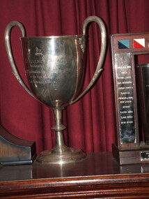
Trophy - Silver Cup, Challenge Cup, Pre WW2
... CHALLENGE CUP PRESENTED TO THE 11TH AUSTRALIAN LIGHT HORSE REGT BY THE HON COLONEL SIR REGINALD TALBOT Maker's detail on edge of base: JAY s 142 & 144 Oxford Street London W Regimental crest Hallmarks - JJ, Queen's Crown, Lion. ...It has been catalogued by the Unit History Room to provide a record of it. trophy mess property CHALLENGE CUP PRESENTED TO THE 11TH AUSTRALIAN LIGHT HORSE REGT BY THE HON COLONEL SIR REGINALD TALBOT Maker's detail on edge of base: JAY s 142 & 144 Oxford Street London W Regimental crest Hallmarks - JJ, Queen's Crown, Lion. ...Object is property of the Regiment. It has been catalogued by the Unit History Room to provide a record of it.Silver cup. with two handles projecting 50 mm above rim of cup.CHALLENGE CUP PRESENTED TO THE 11TH AUSTRALIAN LIGHT HORSE REGT BY THE HON COLONEL SIR REGINALD TALBOT Maker's detail on edge of base: JAY s 142 & 144 Oxford Street London W Regimental crest Hallmarks - JJ, Queen's Crown, Lion. K trophy, mess property -
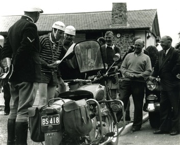 Victoria Police Museum
Photograph (police motorcycle)
... Victoria Police Museum 313 Spencer Street Docklands melbourne police vehicles; wireless patrol; motor transport branch; motor transport section; police motorcycles; ariel motorcycle; bolte, sir henry Lord Somers Camp 1957 Ariel motorcycle, registration number BS-418, with a uniformed police officer standing to the left of the bike and a large group of plain clothed men standing around. To the right is Sir Henry Bolte, former Premier of Victoria, and to the left of him is Lord Mayor R Talbot ...Ariel motorcycle, registration number BS-418, with a uniformed police officer standing to the left of the bike and a large group of plain clothed men standing around. To the right is Sir Henry Bolte, former Premier of Victoria, and to the left of him is Lord Mayor R Talbot. Circa 1957Lord Somers Camp 1957police vehicles; wireless patrol; motor transport branch; motor transport section; police motorcycles; ariel motorcycle; bolte, sir henry -
Federation University Historical Collection
Document, Zelda Martin, Central Victorian Goldmining towns - Boom Towns or Ghost Towns?, c1996
... Steiglitz: Brief History Victorian Post Office Directory 1869 *Map of Steiglitz *List of maps relevant to Steiglitz history *Information 6 tables of data from "Reports of Mining Surveyors Talbot (Back Creek) Brief History Taradale: Post office Directory 1869 - Name/Occupation/Street. ...Steiglitz: Brief History Victorian Post Office Directory 1869 *Map of Steiglitz *List of maps relevant to Steiglitz history *Information 6 tables of data from "Reports of Mining Surveyors Talbot (Back Creek) Brief History Taradale: Post office Directory 1869 - Name/Occupation/Street. ...Zelda Martin was a PhD candidate at the University of Melbourne.[.1] 4th item in light blue display book titled Research Approach/Overview of Chapters/Confirmation of Canditure/Chapters1,2,3&4 of proposed thesis. *Twenty-seven page article on Victorian goldfields towns titled: Central Victorian Goldmining Towns - Boom Towns or Ghost Towns. The article was written during the author's PhD study. It outlines the context methodology, and resources and the chapters of the proposed thesis: (1) Central Victorian Goldmining Towns - The Context (2) Contemporary Views of the Factors Necessary for Town Growth (3) Outward Manifestations of Town Growth (4) The Trappings of Government (5-9) The Main Towns and Their Hinterland. [.2] 5th item in Light Blue display book as above item. *Chapter 1 of proposed thesis titled 'Pick, Shovel and Tin Dish Mining.' Covers in Section A: Central Victoria - Pre 1851: Aborigines in Central Victoria, Squatters, and Government. Section B: The years 1851-1854: The Early Gold Rushes, Government Reaction, Township Surveys, Legislation, Town Development, Local Government and Early Settlement. [.3] 6th item in Light Blue display book as above item. *2A of proposed thesis titled 'Contemporary Views of the Factors Necessary for Town Growth'. Similar information to Chapter 1 plus extra re towns and maps. Sections: Introduction, Context of Place - Geographical Towns Listed, The Context of Time - Pre1851 Aborigines, Governance of Port Phillip, The Squatters, The Villages of Central Victorian Highlands, Conclusion, Condensed Version of Chapter2B. [.4] 7th item in Light Blue display book as above item. *Chapter2B of proposed thesis. Sections: Area of Research, Schools, Banks, Newspapers, Progress Association, Town Development - Sandhurst (Bendigo), Ballarat, Castlemaine,, Maryborough, Ararat and Stawell. [.5] 8th item in Light Blue display book as above item. *Chapter 3 of proposed thesis titled 'Outward Manifestations of Town Growth'. Sections: Introduction, Contemporary Writing, Educationalists, The Bankers, The Townsfolk, Current Theory, General Theories of Urban Development, and Conclusion. [.6] 9th item in Light Blue display book as above item. *Chapter 4 of proposed thesis titled 'Trappings of Government' Sections: Introduction, Early Government Attitudes to Mining and Town Development, Law and Order, Township Surveys, Legislation, Local Government, Transport and Communication, The People and Lobbyists. [.7] 10th item in Light Blue display book as above item. *'The Rise and Fall of Central Victorian Goldmining Towns'. Includes a map showing main Goldfields, a table showing towns and villages at two points in time - 1857 and 1871; a Bibliography of Primary and Secondary Sources. [.8] Resource No1. Black display book titled Local Towns 1 : Alma: *Brief history *Directory *Maps Amphitheatre / Mountain Hut: *Brief History Post Office Directory Ararat: *Brief History *Post Office Directory 1869 - Alphabetical Listing by Occupation *Ararat - Prominent Citizens of 1858 *Langi-Morgala Museum Avoca: *Brief History *Excerpts from 'Avoca The Early Years', Margery and Betty Beavis; pg1 - Beginnings; pg11 - The Midas Touch; pg25 - Local Gold Escorts; pg27 - A Town is Born; pg51- The Administration of Justice; pg53 - The Ways of the Law; pg61 - News of the Day; pg65 - A Time to Play; pg72 - Land Ownership *Post Office Directory (Bailliere's) 1869 *Tourism Map and Information of area *Historic Avoca - A 5.5km Tour *Avoca & the Pyrenees Region - information pamphlet Ballarat: *Early History of Ballarat - Ballarat Historical Society, Publication No.1: origin of the name; Ballaarat - the Beginning; Fabulous Yields from the Ballaarat Goldfield; *Streetscape Lydiard Street. *Hand drawn map showing Leigh River, Old Portland Bay Road, plaque on road to Colac; etc. *Newspaper article re 'The Theatre Royal' ( which stood in the vicinity of the current Owen Williams store) - 'The News'15/04/1998 *Article - 'Ballarat's Mechanics' Institute Lives On' Ballarat Courier, 14/09/1985 *Article - Standing the Test of Time' The News 17/11/1993 re The Mechanics Institute & picture of the Reading Room *'Ballarat a Study of a City, Phyllis Reichl, pub. Nelson, 1968; no.3 place, time and people field studies series *Investigator Vol.33 No.2, 1998 Geelong Historical Society. Article on pg75 describes Ballarat in 1861 *Folded poster - 'Ballarat 100' a history of telegraph communication, pub. Telecom. Beaufort (Fiery Creek): *Brief history *Post Office Directory [.9] Resource No.2 Black Folder Titled Towns cont.No2 Bendigo (Sandhurst): *'Family & Local History at the Bendigo Library - 1851-2001 150 years of gold'. *Bendigo Government Camp in 1853 illustration; key to sketch and names of Government officers stationed there *Excerpts from 'Bendigo and Vicinity' Adolph Haman *The Bendigo Goldfield Registry - pgs 1-7 Introduction *Excerpt: 'Breaking the Grip' *Excerpt: The Most Go-Ahead Place *Excerpts from 'History of Bendigo' - anti license agitation; laying out of town; proposed railway; gold calls and dividends; the Sandhurst Municipality; journalism *Bibliography Blackwood: *Excerpts from 'Aspects of Early Blackwood - The Goldfield, the Landmarks, the Pioneers' Alan J Buckingham and Margaret F Hitchcock, JG Publishing,1980 Buninyong: *A Brief History *Investigator Vol1 No.2 Feb 1966 Geelong Historical Society. Pg3 - Article re gold escort route - Mt Alexander to Adelaide - (see a simple monument on the Western Highway a few miles out of Horsham. Pg 15 - Ballarat Excursion - re the finding of gold. *Three articles published by Buninyong and District Historical Society Inc: (Magpie Exploration; Finding Gold In The Green Hills; Magpie Exploration; Burnt Bridge to Cargarie to Mt Mercer) *Copies of newspaper articles/items *Buninyong Street Directory Carisbrook: *In the Beginning There Was Carisbrook *The History of the Carisbrook Racecourse Carngham / Snake Valley: *Brief History *Directory Castlemaine: *Directory 1865-1866 - Alphabetical and Street *Poster - Castlemaine A Contemporary Guide "The Great Centre" 1866 - A Contemporary Guide to the Fascinating Past *Pamphlet - Castlemaine District Community Hospital *Map - Castlemaine, Maldon & Surrounding Districts *Map and Information - The Dry Diggings Track - a 55kl walk among historic goldfields relics ( Castlemaine Fryerstown Vaughan Mt Franklin Hepburn Daylesford) *Postcard - Former Court House *Directory 1867 - Alphabetical, Trade [.10] Resource No.3 Grey folder Titled Towns 3 Creswick to Maryborough Creswick: *Brief History *Booklet - "Creswick Cemetery Walk" *Booklet - The Buried Rivers of Gold Heritage Trail Creswick *Creswick Historical Museum Information Sheet *Chronological History of Creswick *Alphabetical Directory of the Borough of Creswick *Creswick's Creek Directory 1856 *Historic Creswick Walking Tour *A Brief Account of the Schools of Creswick - Past and Present *100 Years of Railway Travel in Creswick *The Berry Deep Leads *The Spence Home at Jackass Gully in the Creswick State Forest ( William Guthrie Spence - Pioneer) *The New Australian Mine and the 1882 Disaster *Creswick District News, Issue 7, July August 1999 *The Creswick Miners Walk - Information and Map *Maps Chewton: *Brief History *Directory Clunes: *Brief History *Clunes Street Directory Daylesford: *Brief History *Notable Bushfires in Daylesford District Over More Than a Century - "Black Thursday" 1851; 1862; 1899; the Disastrous Hepburn Fire of 1906; 1939; 1944; 1969. *Post Office Directory -Daylesford and Hepburn Dunolly / Inkerman: *Brief History *Directory *Pamphlet - Goldfields Historical Museum *Pamphlet - Historic Dunolly - Victoria's Best Kept Secret *Map of Gold Workings at Dunolly Area - showing where the main gold rushes occurred *Brief History - Inglewood *Directory - Inglewood - Name Occupation, Dwelling Kingower: *Brief History *Directory - Name / Ocupation / Dwelling Linton / Happy Valley / Piggoreet: *Brief History *Directory - Lintons McIvor: *"A History of the Shire and the Township of Heathcote" by J.O. Randell Majorca: *Brief History *Official Post Office Directory 1869 - Name / Occupation/ Address Maldon (Tarrangower): *Brief History Part 1 *Brief History Part 2 *Post Office Directory *List - Alphabetical Order by Names plus Business and Trade (Tarrangower Times Oct/1858) *List - Alphabetical Order by Trade plus Name and Business *Directory - Name / Occupation / Dwelling Maryborough: *Worsley Cottage - built by Arthur Worsley, a contractor in stonework in 1894 [.11] Resource No. 4 Blue Display Book titled Towns 4 Moliagul to Stawell Moliagul: *Brief History *Moligul Legislative Assembly (Voting?) List - Names and Occupations *Moliagul Victorian Post Office Directory 1868 - Name / Ocupation / Address / Comments *"The Welcome Stranger" gold nugget *The Sunday School *The Welcome Stranger Discovery Walk - information and map Moonambel (Mountain Creek) Redbank *Brief History *List of names extracted from advertisments of the Pioneer and Mountain Creek Advertiser 16/02/1861. *Bailliere's Directory 1869 - Alphabetical List of Name / Occupation / Place St Arnaud: *Brief History Sebastapol: *Brief History *Directory 1869 - Alphabetical by Name; plus occupation and address. Browns and Scarsdale: *Brief History *Browns Street Directory - Name and Occupation Smythesdale: *Brief Description *Smythesdale Street Directory -Name and Occupation Stawell (Pleasant Creek) *Brief History *Victorian Official Post Office Directory - Name /Occupation / Dwelling *Chronology - 1841-1920 *Production of gold statistics - 1879 - 1900 *Big Hill *Extracts from "The Golden Years of Stawell". Chapt 1 - Stawell's Coming Out. Capt. 2 - The Gold Rush. Caapt.3 - Cradle of Democracy. Chapt.4 - The Reefs Becomes Stawell. Chapt. 5 - Rushing In. Chapt.6 - The Pioneers. Chapt 7 - The Decade of Optimism. [.12] Resource No. 5: Blue Display Book titled 'Towns Steiglitz to the The Golden Triangle. Steiglitz: Brief History Victorian Post Office Directory 1869 *Map of Steiglitz *List of maps relevant to Steiglitz history *Information 6 tables of data from "Reports of Mining Surveyors Talbot (Back Creek) Brief History Taradale: Post office Directory 1869 - Name/Occupation/Street. Also list in alphabetical order by Occupation Taradale *Chronological Reference to Taradale Mines *Water - The Coliban System of Waterworks *Joseph Brady *The Syphon Tarnagulla (Sandy Creek) *Brief History *Tarnagulla Businessmen Cameos to give depth to advertisments in 'The Tarnagulla Courier' various issues 1864-1871 *Directory - Name/Occupation /Address *List - Name/Business/Trade Wedderburn (Koorong) *Brief History *List - Name/Occupation The Golden Triangle: *The Early Rushes - Wedderburn / Moliagul / Sandy Creek - Tarnagulla / Jones Creek - Waanyarra / Kingower / Dunolly - Goldsborough / Inglweood *Census of 1857 - Population / Occupations *1858-1871 - A Time of Consolidation- Wedderburn / Moliagul / Sandy Creek- Tarnagulla / Arnold *Census 1871 - Population *Information gleaned from the census data - Demographics / Population / Occupations / marital / Birthplace / Religion / Literacy/ Occupation and Housing Cameos *Graphs - Birthplace of settlers /Male-Female Ratio / Married males / Children under 15 as Percentage of Population / Religion *Census 1857 - Statistical data *Maps *Bibliography [.13] Resource No. 6 - Black Display Book Information and Research in Central Victoria including: *Banking - Research from ANZ Bank Archives *Institutions - also includes articles listed from the Ballarat Times Newspaper *Australian mining History Association - A.M.H.A. Bibliography *Australia's Mining History * Bibliography - Land Surveys Victoria - *1853 Administration (Statistics and Other) includes: schools / ministers of religion / police / military / local administration / licences for sale of spirits / distances between various Victorian gold fields. * Victoria Government Gazette (Copy) - N0. 116, 12/12/1854 includes: Gold Felds Commission of Enquiry & No. 85, 15/09/1854 - Addresses presented to the Lieutenant Governor (Sir Charles Hotham) during his tour through the Gold Fields of Victoria,1854. Addresses on behalf of : the people of Bendigo; Members of the Church of England, Bendigo; Members of the Wesleyan Church on the Bendigo Gold Fields; Bendigo Gold District General Hospital; the Bendigo Prospecting Association; Committee of the Bendigo Local Exhibition; Bendigo District Medical Association; Coloured Americans Resident at Bendigo; German Inhabitants of Bendigo; Landowners, Inhabitants, and Miners of Castlemaine; Inhabitants of Forest Creek; Inhabitants of Heathcote and Gold Miners of McIvor; Residents and landholders of the District of Bacchus Marsh; Inhabitants of Kilmore and Vicinity. *Gold Fields Correspondence 1853: letter from Lieutenant Colonel Valiant, (Officer commanding the Troops in Victoria) to the Lieutenant Governor re threatened disturbance at Sandhurst (Bendigo) regarding the Gold License Fee. * Extracts from a book "Victoria" re Gold Fields Commission of Enquiry involving mainly Ballarat and Castlemaine and a chapter titled 'A Tour to the Victorian Gold-Fields' *Lists of central Victorian newspapers - listed by date published 1851to 1874; by first date available to State Library. *A list of cities and towns showing County, population in 1861 &1871, and municipal status. [.14] Resource no.7. Black display book. *Reference: Papers presented to Parliament Victoria - 1859-1860 4 volumes - relevant sections copied. Contains information on Branches of Government. General / Finance / Gold / Gazette / Commission and Warrant / Statistic. *Gold Fields Act. In accordance with the Act the gold fields are divided into six districts - Ballaarat, Castlemaine , Sandhurst, Avoca, Ararat, and Beechworth.. Official staff in each gold district consists of a Resident Warden, Wardens, Wardens' Clerks, Bailiffs, Chinese Protectors, Chinese Interpreters, and Mining Surveyors. *Gold Receiver *Gaols *Police magistrates and Clerks of Petty Sessions, etc. *Field Branch *Immigration and Emigration Overland - Chinese - 1859 *Population on the Goldfields *The Geological Survey - The Government Geologist is assisited by staff from four branches - the office Branch; the Publishing Branch; the Field Branch and the Museum Branch. *Commission to Enquire Into Sludge dated 10/02/1859 (Some sections copied) - Report to the Honorable Chief Commissioner of Public Works, Melbourne re the mode of carrying the sludge from the puddling mills in Sandhurst without interfering with the drainage of the town and the roads in the neighbourhood. [.15] Resource No.8: Camel display book titled Resource No. 8. Aborigines *Lists of book titles - +"Readings in Victorian prehistory" +"The Aborigines of Port Phillip" +Aboriginal languages and clans" +"A History of the Port Phillip District" +"Langi Ghiran 1: Aboriginal Rock...." +"Koorie History: sources for aboriginal studies in the State Library of Victoria", ed. Tom Griffiths, Melb. Friends of the State Library, 1989 +"The Public Lands of Australia Felix"; settlement and land appraisal in Victoria1834-91 with special reference to the Western Plains", J.M.Powell, Melb. Oxford University Press 1970 +*Bibliography of the Victorian Aborigines' from the earliest manuscripts to 31st December 1970, Massoa, Aldo, Melb. Hawthorn Press, 1971 +"Aborigines in Colonial Victoria, 1836-1886", M.F. Christie, Sydney University Press, 1979 +"Urban and Industrial Australia: readings in Human Geography" ed J.M. Powell, Melb. Sorrett Pub. 1974 *Extracts: -Processes of Pioneer Settlement - The Squatting Occupation of Victoria, 1834-60. J.M. Powell -Areal Variations in the Class Structure of the Central-Place Hierarchy. P. Scott - Volume1 and Volume 2: Notes Relating to the Habits of the Natives of Other Parts of Australia and Tasmania. Compiled from various sources for the Government of Victoria by R Brough Smyth. John Curry, O'Neil, Melb. 1st pub. Melb. 1876. p31-45 - Numbers and Distribution of the Aborigines in Victoria -Victorian Aborigines 1835-1901 - A Resource Guide to the Holdings of the Public Record Office, Victoria; published by the Government Information Centre 1984. *History of the Aboriginal Artefacts Displayed in the Daylesford Museum. F. G. Powell (4 page pamphlet) *Letter to Zelda Martin from Peter Lovett, Cultural Officer, Ballarat & District Aboriginal Co- Operative, 05/02/1997 *Map: Ian Clarke Victorian Tribunal Boundary Map - Clans of Central Victoria. *Victorian Rock Art and Mythology - Article about Mount Langhi Ghiran and myths of the Tjapwarong people. *Two Aboriginal myths relating to the Grampians - 'The Monster Emu' / 'The Aquisition of Fire', by the Aborigines in the Grampians Areas *Article titled (chapter 8) Ballarat - information re camping sites in the region. Lake Wendouree / Lake Burrumbeet (includes a myth) / Mt Bunninyong / Lal Lal / Pitfield / Mount Elephant / Mount Egerton / Meredith / Lake Goldsmith / Lake Learmonth / Ercildoune *Notes on the Aborigines of the Wider Ballarat Region plus European names=Aboriginal names. John Morris 26/07/1995 *Role of Aborigines in Town Development in Central Victoria. Mentions Native Police Force est. in Port Phillip 1842 and Central Board for Aborigines est. 1860 *The Grave of King Billy. (Frank Wilson) Pamphlet. *Camping Places in Central and Northern Victoria. Article re Lake Burrumbeet site. *Programme for the Unveiling of Memorial Cairn for Edward Stone Parker 1802-1865. Note portrait not accurate. Accurate portrait is available in the book "A Successful Failure A Trilogy The Aborigines and Early Settlers", Edgar Morrison, Graffiti Publications, 2002. * Large envelope addressed to Mr G Netherway containing newspaper cuttings regarding the life of Edward Stone Parker, the unveiling of the Memorial Cairn as mentioned above, articles titled 'Episodes from Our Early Days' (Edgar Morrison, Yandoit)- The Black's School, A School At Last and The Final years. Also a typed page titled 'Historical Background to E.S.Parker's Career. Includes an interesting tale titled 'When the cat lay doggo' re laying power leads for the unveiling ceremony at the memorial site. [.16] green display folder titled 'Research Aids' *List of references to Commissioners' & W'ardens' Reports (formerly held at La Trobe Library Archives, now at Public Records Office [PRO]). Indicates town referred to / date of report / name of camp if different to town. * Archive information re Anglican Records *Movement around the Goldfields - Miners and Storekeepers - usefulness of newspapers in providing information - areas covered - Castlemaine, Maldon, Ararat, Stawell, Tarnagulla, Dunolly. *Port Phillip /Victoria Directories 1839/1867 - Chronological list of Directories included in this series. *"Notes on the History of Local Government in Victoria" A.W. Greig Melb. University Press 1925 - Photo-copied extract p5-p40. (Source - Deakin University Library) - Introduction by W.Harrison Moore. Section 1 - Development in New South Wales Before Separation. Section 2 - Development in Victoria After Its Separation from New South Wales. Hand written notations: 'roads, markets, and local government 1855 on' ;'opportunity of squatters in parliament' and 'opportunities of matters in parliament p33' * Notes on the Establishment of Surveyor General's Department 1851and Commissioner of Crown Lands and Survey. * Newspaper articles from The Argus, 1849, re the discovery of gold in the Pyrenees region. * Excerpt - a report on schools - A.B.Orlebar, Inspector; re the need for permanent school buildings rather than tents. *Excerpt from - 'Approaches to Urban History', Sean Glynn: The Case for Caution * Except from - 'The Urban Sprinkle', Weston Bate: Country Towns and Australian Regional History *Reference- 'The History of Land Tenure in the Colony of Victoria', John Quick. References the Haines Land Bill, land tenure and Land Leagues. [.17] Light blue envelope folder titled 'Birtchnell's Ballarat, etc. Directory 1862 *Contains various directories for Smythesdale, Buninyong, Clunes, Brown's and Creswick. [.18] Red envelope folder no.2 titled Victorian Gazetteer *Selected pages from 1869 Victorian Gazetteer on A4 paper (with a handwritten note questioning if some pages are from 1868 Victorian Gazetteer as appears to be different sizes - A3 pages.) Information includes locations and descriptions of towns, hotels, banks, communications and populations. (Does not include names, residences and occupations) [.19] Red Envelope folder titled Bailliere's Official Post Office Directory 1868 (or1869 or a mixture of both?) *Preface *Contains a selection of pages of towns highlighted in yellow in the the index *Work on this directory was commenced in 1867. *Information includes: Municipalities - mayors and councilors; lists of towns naming male inhabitants and their occupations. [.20]Yellow manila folder titled Post Grad Seminar Presentation 1996 *Gives some background to Zelda Martin's proposed thesis and why she chose the topic Gold Mining Towns Boom or Bust [.21] A3 display book - No. 1A * A list of 'Relevant Newspapers collected: The Tarrangower Times and Maldon Advertiser (first published 1858) Includes dates 1858-1867. The Mount Alexander Mail. Includes dates 1854-1866 The Tarnagulla Courier. Includes dates from1864-1871 Dunolly and Burnt Creek Express. Includes dates from 1862-1871 * Selection of newspaper pages from The Mount Alexander Mail 1854 to 1856, mostly showing advertisements for businesses and services provided to that community. [.22] A3 display book - No. 1B * Selection of newspaper pages from The Mount Alexander Mail 1857 to 1866, mostly showing advertisements for businesses and services provided to that community. [.23] A3 display book -No. 2 * Selection of newspaper pages from The Tarnagulla Courier 1864 to 1871, mostly showing advertisements for businesses and services provided to that community. [.24] A3 display book - No. 3 *Selection of newspaper pages from The Tarrangower Times (and Maldon and Newstead) Advertiser 1858 to1867, mostly showing advertisements for businesses and services provided to that community. [.25] A3 display book - No.4 * Selection of newspaper pages from The Dunolly and Burnt Creek Express; and The Dunolly and Betbetshire Express 1862 to 1871, mostly showing advertisements for businesses and services provided for that community. [.26] A3 display book - No.5 Includes: * Bryce Ross's Diggings Directory. Includes instructions for using this directory. This directory was used by "all persons having connexion or desiring to communicate with 'working parties, private friends, or Stores at the Diggings." As a directory for each area wwas completed it was published in each month's issue of Bonwick's "Digger's Magazine." Years c1852/1853. This Directory commences first at the head of Forest Creek. Includes a directory for Bendigo and Ballarat. Of interest at the end of the Bendigo and Ballarat directory is a list of the number of storekeepers, butchers, doctors, smiths, eating houses, lemonade sellers and chapels. * The Castlemaine Directory and Book of General Information Comprehending Glass's Model Calendar for the Two Years 1862 and1863. "zelda martin, victorian goldfield towns, bendigo, castlemaine, ballarat, maldon, stawell, ararat, maryborough, creswick, avoca, heathcote, banks, bank of australasia, union bank of australia, government camp, sandhurst, water supply, tarnagulla, talbot, back creek, mountain creek, police court, carisbrook, dunolly, thompson's foundry, charles clacy, anthony trollope, robert cecil, mount alexander, urbanisation, national schools, education, govenrment, industry, railway, transport, settlement, land settlement in central victoria, steiglitz, joseph brady, the new australian mine, berry deep leads, william guthrie spence, creswick state forest, arthur worsley, worsley cottage, the welcome stranger, moliagul, moonambel, redbank, st arnaud, sebastapol, brown's, scarsdale, clunes, chewton, daylesford, bushfires, inkerman, inglewood, kingower, lintons, happy valley, piggoreet, mcivor, majorca, tarrangower, taradale, the coliban system, the syphon, sandy creek, wedderburn, koorong, arnold, jones creek, waanyarra, the golden triangle, census 1857, blackwood, buninyong, durham lead, magpie, carngham, snake valley, alma, amherst, daisy hill, amphitheatre, mountain hut, beaufort, fiery creek, counties, population, gold fields commission of enquiry1854, william westgarth, gold license fee, lieutenant colonel valiant, administration of the victorian gold fields, commission to enquire into sludge 1859, e.s. parker, edward stone parker, edgar morrison, mount franklin protectorate, dja dja wurrung, memorial cairn, franklinford, mt franklin memorial cairn, jajowurrong, dja dja wurung, tjaowarong, wothowurong, assistant protectors, daylesford museum, buluk, rock art - grampians, aboriginal mythology - grampians, aborigines, first nations people, mount franklin, aboriginal artifacts, lake burrumbeet, native police force, central board of aborigines, yandoit, commissioners' reports, wardens' reports, port phillip/victoria directories 1839-1867, local government - victoria 1853/1854, surveyor general's department - 1850's, victorian schools 1850's, a.b.orlebar, haines land bill, william charles haines, wilson gray, land tenure, land leagues, victorian gazetteer, the tarrangower times and maldon advertiser - 1858-1867, the mount alexander mail 1854-1866, the tarnagulla courier 1864, dunolly and burnt creek express 1862-1871, bryce rose's diggings directory, the castlemaine directory 1862-1863 -
Marysville & District Historical Society
THE TRIANGLE NEWS-VOL 38 NO 13-APRIL 29 2011
... Marysville & District Historical Society 39 Darwin Street Marysville yarra-valley-and-the-dandenong-ranges marysville victoria australia beeches trail parks victoria meeting of the waters lush rainforest lady talbot drive phantom falls cambarville cathedral range state park community walks whitefoot dunnart dse camera survey points set up lake eildon national park gallipoli park reopens the reflective garden victorian bushfire appeal fund gallipolli park committee of management advertisements buxton silver gum secrets revealed by fires council to hold budget meeting murrindindi shire council THE TRIANGLE NEWS-VOL 38 NO 13-APRIL 29 2011 ...marysville, victoria, australia, beeches trail, parks victoria, meeting of the waters, lush rainforest, lady talbot drive, phantom falls, cambarville, cathedral range state park, community walks, whitefoot dunnart, dse, camera survey points set up, lake eildon national park, gallipoli park reopens, the reflective garden, victorian bushfire appeal fund, gallipolli park committee of management, advertisements, buxton silver gum secrets revealed by fires, council to hold budget meeting, murrindindi shire council -
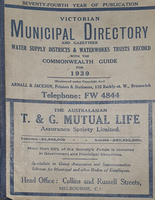 Federation University Historical Collection
Book - Street Directory, Arnall & Jackson Pty Ltd, Victorian Municipal Directory and Gazatteer, 1939, 1939
... Victorian municipalities municipal councils water supply advertisements Aboriginal Protection Board Agriculture Charities county court crown lands and survey Engine Drivers Board Licensing Court Sludge Abatement Board Cities towns boroughs Ballarat Buninyong Gordon grenville Talbot Traralgon Ballaarat Happy Valley Bungaree Daylesford Glenlyon Glenlyon Shire Hepburn SPrings Beige cover with blue spine. 1052 pages. It includes an index to townships, parishes and Railway stations. Victorian Municipal Directory and Gazatteer, 1939 Book Street ...Beige cover with blue spine. 1052 pages. It includes an index to townships, parishes and Railway stations. non-fictionvictorian municipalities, municipal, councils, water supply, advertisements, aboriginal protection board, agriculture, charities, county court, crown lands and survey, engine drivers board, licensing court, sludge abatement board, cities, towns, boroughs, ballarat, buninyong, gordon, grenville, talbot, traralgon, ballaarat, happy valley, bungaree, daylesford, glenlyon, glenlyon shire, hepburn springs -
Glen Eira Historical Society
Book - CAULFIELD CENTENARY 1957
... Talbot milk supply... Jenner family... O’Niell College... Presentation Sisters... Glenferrie Road... Grimwade Frederick Sheppard... Grimwade Alice... ‘Harlston’... Grimwade House... ‘Saint Aubin’s’... ‘St. Aubin’s’... ‘Caulfield Hall’... Caulfield John P.T.... St Georges Road... Caulfield Military Hospital... Nursing homes... Health establishments... Dover Street...Loyd Charles du Plan Hope George ‘Airdrie’ Kooyong Hill Market gardens Dairies Lady Talbot milk supply Jenner family O’Niell College Presentation Sisters Glenferrie Road Grimwade Frederick Sheppard Grimwade Alice ‘Harlston’ Grimwade House ‘Saint Aubin’s’ ‘St. Aubin’s’ ‘Caulfield Hall’ Caulfield John P.T. St Georges Road Caulfield Military Hospital Nursing homes Health establishments Dover Street ...This file contains four items 1/Two copies of a twenty-four page booklet titled CITY OF CAULFIELD CENTENARY 1857-1957, created by the Caulfield City Council and printed by Peter Isaacson Pty Limited, Melbourne. The booklet details important aspects of Caulfield’s history including council procedures, the Caulfield Road District Proclamation, the first election and a summary of 100 years of local government with a description of the present Caulfield in 1957. The booklet also includes several pictures of various Caulfield landmarks and people including one of Caulfield City Councillors (11 men and 1 woman). Also one photocopied version of this booklet. 2/Eleven pages of typed notes for the City of Caulfield Centenary booklet. All notes are undated and incomplete. Two pages titled NOTES on THE HISTORY and PROGRESS OF THE CITY OF CAULFIELD, author unknown. Three and a half pages titled THE STRUCTURE OF LOCAL GOVERNMENT IN VICTORIA, author unknown. Five pages titled 100 YEARS OF LOCAL GOVERNMENT – EARLY CAULFIELD, by Mrs A. P. Bell. 3/A typed letter to Miss V. Webb-Langdon from the Town Clerk H.G. Nelson, acknowledging her contribution to historical details for the Caulfield Council’s Centenary booklet, dated 24/12/1957. 4/A handwritten letter and a handwritten note regarding the acquisition of notes for the Caulfield Centenary booklet. The letter is dated 03/08/2006 and the note is dated 09/02/2007.city of caulfield centenary, caulfield road district, sinclair a.j.g., city hall, war memorials, gamble h.a., machin l.r., bunny f.c.d., caulfield park, koornang reserve, parton e.m., sims h.e., thomson w.r., gunn e.e., yorston j.s., wallace g.e. mrs, green w.c., jenner e.r., ward boundaries, dandenong road, queens avenue, normanby road, station street, bond street, glen eira road, orrong road, poath road, north road, booran road, nepean highway, glen huntly road, glenhuntly road, inkerman road, hotham street, nelson h.g., fullard w.r., mackley g.j., ellis k.i, crosbie m.r., nutting b.i., body j.h., pritchard r.j., guildford l.t.g., lund l.m., street h.c., reynolds a.w., elections , political processes, local government, springthorpe reserve, greenmeadows gardens, business and finance, roads and streets, caulfield racecourse, east caulfield reserve, mackinnon reserve, hawthorn road, balaclava road, murrumbeena road, lempriere avenue, victoria street, koornang road, lord reserve, lyons street, murrumbeena reserve, kangaroo road, ormond park, beatty crescent, foch street, packer reserve, oakleigh road, leila road, prices park, bambra road, riley reserve, playgrounds, town hall, maternal and child health centres, truganini road, grange road, senior citizens centre, barkley sir henry, moore david, handasyde gilbert, caulfield school room, harris g.w., semple john, dempsey william, brooks w.a., wilson thomas, lyall william, murrum murrumbeen lifestyle, ‘greenmeadows’ house, lempriere family, aboriginal culture, ‘rippon lea’ house, caulfield john, ‘slaney’s’ home, alma road, paddy’s swamp, racecourse hotel, caulfield technical college, bevan mr., ‘grosmont’, hart john, railways, mansions, ‘rosecraddock’, langdon h. j., caulfield cup, ‘crotonhurst’, webb judge, ‘kilwinning’, service james, ricketson henry, ‘glen eira’, house names, garden vale, ross william murray, ‘ross’s folly’, outer circle railway, caulfield grammar school, davies j. henry, lagdon william, grimwade f.s., loyd charles du plan, hope george, ‘airdrie’, kooyong hill, market gardens, dairies, lady talbot milk supply, jenner family, o’niell college, presentation sisters, glenferrie road, grimwade frederick sheppard, grimwade alice, ‘harlston’, grimwade house, ‘saint aubin’s’, ‘st. aubin’s’, ‘caulfield hall’, caulfield john p.t., st georges road, caulfield military hospital, nursing homes, health establishments, dover street, sports and recreations, rosanna street, ‘cantala’, health services, parks and reserves, community services, town planning, local government finance, local officials and employees -
Glen Eira Historical Society
Document - Bambra Road Methodist Church, Northcote Avenue
... Street And Directory References. Bambra Road Bambra Road Methodist Church Caulfield North Everett L.D. St Stephen’s Presbyterian Church Caulfield Alday Thomas Rev Everett Win Bambra Road Trustees Alday Thomas Mrs Everett Keith Caulfield Park Caulfield Park Bowling Club Heazlewood Vere Goddard Sydney Smith Ray J. M. Hilton Della Northcote Avenue Pask N. H. Goff J. T. J Talbot ...Photocopy Of A 2 Page Extract From A Coming Together Book Compiled By Gwenda Mann Describing The History Of Bambra Road Methodist Church. It Contains Information From 75 Years At St Stephen’s Caulfield, Including Union With Bambra Road Methodist Church By Della Hilton, 1985. A Photograph Of Several Small Extracts From This Publication Is Also Included. Also Brief Note By Claire Barton Dated 07/05/2010 With Street And Directory References.bambra road, bambra road methodist church, caulfield north, everett l.d., st stephen’s presbyterian church caulfield, alday thomas rev, everett win, bambra road trustees, alday thomas mrs, everett keith, caulfield park, caulfield park bowling club, heazlewood vere, goddard sydney, smith ray j. m., hilton della, northcote avenue, pask n. h., goff j. t. j, talbot n. e. g, lavender j. c., o’ connor t. m., smith r. j. m, selomb h. w., hawkins h. l, freeman j. t., mannering c. w. j., gray n. a., weatherlake r. c., croxford r. l. g., wilson g. rev., small h. rev., dunstan a. rev., caulfield methodist circuit, caulfield council, anderson mrs., caulfield north, religious groups, methodist church, uniting church, clergy, sunday schools, organs, church furniture, stained glass. -
Glen Eira Historical Society
Article - Regent Street, 38, Elsternwick
... Street... Elsternwick... Townhouses... Caulfield... Spicer Stanley... Darvell Tania... Persichetti Leonard... Real estate agents... Stefanis Angelos... Stavrakis Bill... St Kilda... Glen Huntly... Talbot...Regent Street Elsternwick Townhouses Caulfield Spicer Stanley Darvell Tania Persichetti Leonard Real estate agents Stefanis Angelos Stavrakis Bill St Kilda Glen Huntly Talbot Birner Morley Victorian style Architectural features Article Regent Street, 38, Elsternwick ...Five newspaper advertisements for the sale of townhouses located at 38 Regent Street. The articles give details on the townhouses for sale; 1/38, 2/38 and 7/38, and are dated 04/08/2000, 04/05/2002, 01/09/2000 and 07/09/2001. The articles include coloured photographs of the house interiors and exteriors.regent street, elsternwick, townhouses, caulfield, spicer stanley, darvell tania, persichetti leonard, real estate agents, stefanis angelos, stavrakis bill, st kilda, glen huntly, talbot birner morley, victorian style, architectural features -
Glen Eira Historical Society
Letter - Elsternwick Congregational Church – Caulfield Union Church
... Street... Glen Huntly Road... Melbourne Neon Ltd... Balaclava Road... Whiteway Neon P.L.... N. and D. Panagiotou... Nepean Highway... H.C. Sleigh Ltd.... Poath Road... Carden W. J.... Warren R.P.... Talbot...Committee Congregational Church Orrong Road Victorian Music Theatre Pty Ltd King Street Glen Huntly Road Melbourne Neon Ltd Balaclava Road Whiteway Neon P.L. N. and D. Panagiotou Nepean Highway H.C. Sleigh Ltd. Poath Road Carden W. J. Warren R.P. Talbot ...One page of Caulfield Council’s E.S. and P. Committee agenda, item and minutes dated 14/05/1971 concerning permit application from St. John’s Uniting Church for the Victorian Music Theatre Pty Ltd to Conduct singing lessons in the church building. Typed letter dated 08/12/1987 from National Trust to St. John’s Parish noting the Trust’s classification of the church building and the accompanying citation. Typed letter dated 20/07/1988 from the historic buildings council to Caulfield Historical Society concerning the hearing to discuss inclusion of the church building on the register to be held on 24/08/1988. Copy of historic building council’s agenda item undated describing the significance of the former Union Church. Thirteen page assessment of the architectural significance of the former Union Church dated 24/08/1988 by Anne Neale. Includes sketch of the exterior and references. Handwritten notations by Jim O’Loghlin dated 24/08/1988. Photocopy of the page from the Victoria Government Gazette dated 05/10/1988 advertising the amendment of the register of historic buildings to include the former Union Church building. A twelve page document produced by the Historic Buildings Council Victoria, date unknown, which describes the council’s operations and activities.st. john’s parish of the uniting church, e.s. and p. committee, congregational church, orrong road, victorian music theatre pty ltd, king street, glen huntly road, melbourne neon ltd, balaclava road, whiteway neon p.l., n. and d. panagiotou, nepean highway, h.c. sleigh ltd., poath road, carden w. j., warren r.p., talbot avenue, new l. mrs., elsternwick, zoning, st. georges road, architectural features, caulfield union church, towers, de lacy evans george, mcmurtie mcnaughton and stewart, glen eira road, neale anne i., mcloghlin jim, architectural styles, gothic style, caulfield, caulfield historical society, gregson w. rev., st. aloysius caulfield, brick -
Glen Eira Historical Society
Article - Elizabeth Street, 30, Elsternwick, formerly Trengrove
... Street... Elsternwick... Sargood Fredericl Sir... Bent Thomas... Hannon S J Mrs... Georgian revival style... Gardens... Architectural features... Walling Edna... Flats... House names... Talbot...Rippon Lea estate Elizabeth Street Elsternwick Sargood Fredericl Sir Bent Thomas Hannon S J Mrs Georgian revival style Gardens Architectural features Walling Edna Flats House names Talbot Birner Morley Trengrove Architectural styles Grant-Drew Maurice Article Elizabeth Street, 30, Elsternwick, formerly Trengrove ...A one page article from the Southern Cross newspaper, dated 09/12/1998, on page 12, for the auction of the mansion at 30 Elizabeth Street. The article includes a brief history of the existence of a 1908 property called "Trengrove", occupancy of the current house built for Mrs SJ Hannon after the demolition of "Trengrove" in 1937, mention of the Edna Walling-designed garden, a description of the property and the interior plan and three colour photographs (168mm x 121mm; 59mm x 78mm; 58mm x 73mm) taken by Maurice Grant-Drew.rippon lea estate, elizabeth street, elsternwick, sargood fredericl sir, bent thomas, hannon s j mrs, georgian revival style, gardens, architectural features, walling edna, flats, house names, talbot birner morley, trengrove, architectural styles, grant-drew maurice -
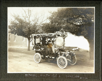 Bendigo Historical Society Inc.
Photograph - EASTER 1908 - TWO FEMALES IN TALBOT CAR, 1908
... History House 11 Mackenzie Street Bendigo goldfields PERSON Group easter procession W Vincent Kelly, Mitchell St., Bendigo. Sepia? Photograph on green board of W Beebe's 8-10 Talbot Car, Easter 1908. ...Sepia? Photograph on green board of W Beebe's 8-10 Talbot Car, Easter 1908. Bendigo car is decorated with paper flowers and streamers. Two female figures seated in front seat. Photo on dark grey mount. Inscriptions: Hand printed below image 'W Beebe's 8-10 Talbot car. Easter 1908, Bendigo'W Vincent Kelly, Mitchell St., Bendigo.person, group, easter procession -
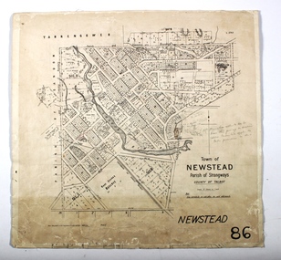 Bendigo Historical Society Inc.
Map - NEWSTEAD, 15/10/1912
... History House 11 Mackenzie Street Bendigo goldfields MAP Talbot township Newstead County of Talbot Map: Town of Newstead, Parish of Strangways, County of Talbot Map NEWSTEAD ...Map: Town of Newstead, Parish of Strangways, County of Talbotmap, talbot, township, newstead, county of talbot -
 Bendigo Historical Society Inc.
Map - PARISH OF RAVENSWOOD, Circa 1908
... History House 11 Mackenzie Street Bendigo goldfields MAP Bendigo parish plan Ravenswood County of Talbot Map: Parish of Ravenswood, Counties of Bendigo and Talbot. ...Map: Parish of Ravenswood, Counties of Bendigo and Talbot. Parish planmap, bendigo, parish plan, ravenswood, county of talbot