Showing 19 items matching "tellurometer"
-
 National Vietnam Veterans Museum (NVVM)
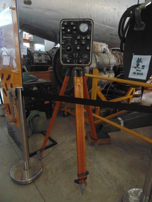
Equipment - Equipment, Army, Tellurometer
... Tellurometer......Tellurometer...A tellurometer on a tripod. the tellurometer is a box shaped with a black front with severla dials and guages on it. the colour of the box is green. ...National Vietnam Veterans Museum (NVVM) 25 Veterans Drive Newhaven phillip-island-and-the-bass-coast 131 Division Tellurometer Tripod A tellurometer on a tripod. the tellurometer is a box shaped with a black front with severla dials and guages on it. the colour of the box is green. ...A tellurometer on a tripod. the tellurometer is a box shaped with a black front with severla dials and guages on it. the colour of the box is green. There is also a carry handle on top of the box. The Tellurometer is positioned on a three legged tripod131 division, tellurometer, tripod -
 National Vietnam Veterans Museum (NVVM)
Functional Object, Tellurometer Tripod, 1958
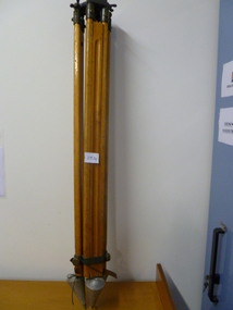
... Tellurometer Tripod......Tellurometer...Three legged timber adjustable tripod with metal conical feet and metal tellurometer base fitment...National Vietnam Veterans Museum (NVVM) 25 Veterans Drive Newhaven phillip-island-and-the-bass-coast Tripod Tellurometer Engraved number - 150517 on legs, Adhesive label with "Australian Survey Office" with written number A404 21 Three legged timber adjustable tripod with metal conical feet and metal tellurometer base fitment Tellurometer Tripod Functional Object Functional Object ...Three legged timber adjustable tripod with metal conical feet and metal tellurometer base fitmentEngraved number - 150517 on legs, Adhesive label with "Australian Survey Office" with written number A404 21tripod, tellurometer -
 National Vietnam Veterans Museum (NVVM)
Booklet, Australian Army, British Army: Directions for the Use of Aartillery Instruments : Pamphlet No. 9: Distance Measuring Equipment MRA 2 (Tellurometer), 1961 (Copy 2), 1961
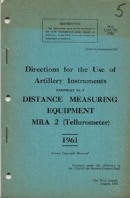
... British Army: Directions for the Use of Aartillery Instruments : Pamphlet No. 9: Distance Measuring Equipment MRA 2 (Tellurometer), 1961 (Copy 2)......Tellurometer...British Army: Directions for the Use of Aartillery Instruments : Pamphlet No. 9: Distance Measuring Equipment MRA 2 (Tellurometer), 1961 (Copy 2) Booklet Australian Army British Army ...A blue coloured cardboard cover. the information is written in black ink. Top right hand corner is the number five which has been written in black texta. Une this is W.O. Code No. 9726. Part of the top half of the cover is faded. There are three punch holes and two metal staples down the left hand side. Also contains Amendments No. 1 which is held together by a metal staple and is inside of the booklet. Top right hand corner reads 7610-66-013-9800/1. Under this reads W Code No 9726-2 (Aust) and this amendment is done by Army Headquaters, Canberra on the 1 Sep. 68. There are three punch holes down the left hand side of the amendment.australia - armed forces - service manuals, british army, artillery instruments, distance measuring equipment, tellurometer -
 National Vietnam Veterans Museum (NVVM)
Booklet, Australian Army, British Army: Directions for the Use of Aartillery Instruments : Pamphlet No. 9: Distance Measuring Equipment MRA 2 (Tellurometer), 1961 (Copy 1), 1961
... British Army: Directions for the Use of Aartillery Instruments : Pamphlet No. 9: Distance Measuring Equipment MRA 2 (Tellurometer), 1961 (Copy 1)......Tellurometer...British Army: Directions for the Use of Aartillery Instruments : Pamphlet No. 9: Distance Measuring Equipment MRA 2 (Tellurometer), 1961 (Copy 1) Booklet Australian Army British Army ...A blue coloured cardboard cover. the information is written in black ink. Top right hand corner is the number four which has been written in black texta. Une this is W.O. Code No. 9726. The top half of the cover is faded. There are three punch holes and two metal staples down the left hand side. Also contains Amendments No. 1 which is held together by a metal staple and is inside of the booklet. Top right hand corner reads 7610-66-013-9800/1. Under this reads W Code No 9726-2 (Aust) and this amendment is done by Army Headquaters, Canberra on the 1 Sep. 68. There are three punch holes down the left hand side of the amendment.australia - armed forces - service manuals, british army, artillery instruments, distance measuring equipment, tellurometer -
 Bendigo Military Museum
Administrative record - Trilateration with the Tellurometer - GRL Rimington 1958, Department of National Development , ACT, 26 May 1958
... Trilateration with the Tellurometer - GRL Rimington 1958...trilateration with the tellurometer by GRL Rimington L.S MIS (Aust) Chief Topographic Surveyor, Department of National Development, Australia. ...Trilateration with the Tellurometer - GRL Rimington 1958 Administrative record Trilateration with the Tellurometer - GRL Rimington 1958 Department of National Development , ACT ...trilateration with the tellurometer by GRL Rimington L.S MIS (Aust) Chief Topographic Surveyor, Department of National Development, Australia. This paper was delivered to the Institute of Surveyors Conference, Brisbane 26 May 1958. This paper is a summary of Electronic distance measurements carried out in 1957 in Central Australia by officers of the division of National Mapping, Department of National Development. Trilateration is a surveying Technique that uses measurements of the sides of triangles to determine relative position.A 11 page foolscap size stapled paper report. Two holed punched with dis-coloured pages due to age.royal australian survey corps, rasvy, fortuna, army survey regiment, army svy regt, asr, division of national mapping, surveying -
 Bendigo Military Museum
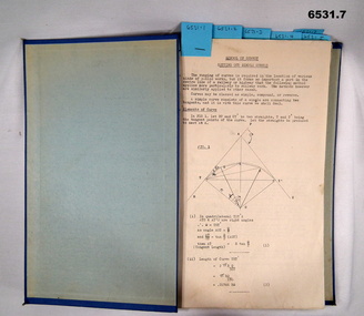
Booklet - Royal Australian Survey Corps - School of Military Survey Precis - Formula for Survey Calculations, School of Military Survey, Balcombe, Circa 1960s
... The blue hard covered foolscap sized booklet held together with two Chicago screws contains 7 x precis listed below. .1 Setting out simple Curves .2 Earthworks .3 Calculation of area by double Latitude .4 Notes on Station Adjustment by Least Squares .5 Notes on Figure Adjustment by Least Squares .6 Technical Memo No1, Computation of Tellurometer Traverses using Plain Angles and Plain Distances by WO2 R Wilson RASvy (later Major) .7 Computing Traverses in Plane Coordinates...Booklet contains 7 x precis. .1 Setting out simple Curves .2 Earthworks .3 Calculation of area by double Latitude .4 Notes on Station Adjustment by Least Squares .5 Notes on Figure Adjustment by Least Squares .6 Technical Memo No1, Computation of Tellurometer Traverses using Plain Angles and Plain Distances by WO2 R Wilson (later Major) .7 Computing Traverses in Plane Coordinates...Booklet contains 7 x precis. .1 Setting out simple Curves .2 Earthworks .3 Calculation of area by double Latitude .4 Notes on Station Adjustment by Least Squares .5 Notes on Figure Adjustment by Least Squares .6 Technical Memo No1, Computation of Tellurometer Traverses using Plain Angles and Plain Distances by WO2 R Wilson (later Major) .7 Computing Traverses in Plane Coordinates Royal Australian Survey Corps - School of Military Survey Precis - Formula for Survey Calculations Booklet Royal Australian Survey Corps - School of Military Survey Precis - Formula for Survey Calculations School of Military Survey, Balcombe ...This selection of Precis was produced by the Royal Australian Survey Corps, School of Military Survey, Balcombe, circa 1960s. The Precis are intended to instruct RASvy Surveyors employed on Engineer/ Field Survey Tasks on the calculations necessary for Surveying formula. The blue hard covered foolscap sized booklet held together with two Chicago screws contains 7 x precis listed below. .1 Setting out simple Curves .2 Earthworks .3 Calculation of area by double Latitude .4 Notes on Station Adjustment by Least Squares .5 Notes on Figure Adjustment by Least Squares .6 Technical Memo No1, Computation of Tellurometer Traverses using Plain Angles and Plain Distances by WO2 R Wilson RASvy (later Major) .7 Computing Traverses in Plane CoordinatesBlue Hard covered foolscap sized booklet held together with two Chicago screws. Booklet contains 7 x precis. .1 Setting out simple Curves .2 Earthworks .3 Calculation of area by double Latitude .4 Notes on Station Adjustment by Least Squares .5 Notes on Figure Adjustment by Least Squares .6 Technical Memo No1, Computation of Tellurometer Traverses using Plain Angles and Plain Distances by WO2 R Wilson (later Major) .7 Computing Traverses in Plane Coordinatesroyal australian survey corps, rasvy, fortuna, army survey regiment, army svy regt, asr, school of military survey -
 Bendigo Military Museum
Photograph - Army Survey Regiment Personnel – Mahogany Ship Survey, Warrnambool, VIC, 1985
... CPL Mark Lander and SGT Don Williams were taking electronic distance measurements using an MRA-301 tellurometer. To measure the distance, personnel at another site operating another MRA-301 tellurometer would have exchanged the signal emission. ...CPL Mark Lander and SGT Don Williams were taking electronic distance measurements using an MRA-301 tellurometer. To measure the distance, personnel at another site operating another MRA-301 tellurometer would have exchanged the signal emission. ...This is a photograph of Army Survey Regiment personnel undertaking surveying measurements during a search for the ‘Mahogany Ship’ Warrnambool, VIC on 3rd September1985. CPL Mark Lander and SGT Don Williams were taking electronic distance measurements using an MRA-301 tellurometer. To measure the distance, personnel at another site operating another MRA-301 tellurometer would have exchanged the signal emission. A ‘Hilga Watts’ light appears in the background and a barometer in the foreground.This is a photograph of Army Survey Regiment personnel undertaking surveying measurements during a search for the ‘Mahogany Ship’ Warrnambool, VIC on 3rd September1985. The photograph was printed on photographic paper and is part of the Army Survey Regiment’s Collection. The photograph was scanned at 300 dpi. L to R: CPL Mark Lander, SGT Don Williams‘R.S. 3/9/1985 CPL Mark Lander, SGT Don Williams PIC BY COURTESY OF THE WARRNAMBOOL STANDARD’ annotated on back of photoroyal australian survey corps, rasvy, army survey regiment, army svy regt, fortuna, asr, surveying -
 Bendigo Military Museum
Photograph - Field Trip near Weipa, Far North Queensland, 1962
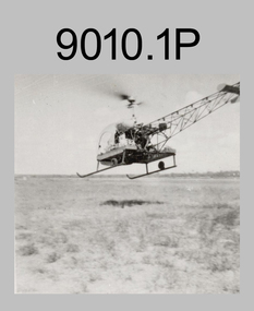
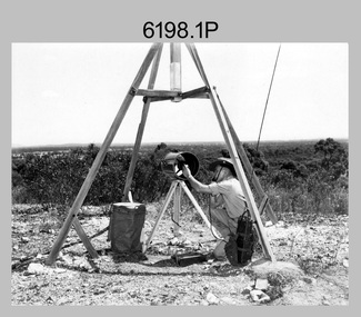
... Field Trip - Tellurometer traverse, Mount Tozer to Weipa, Far North Queensland 1962. ...Field Trip - Tellurometer traverse, Mount Tozer to Weipa, Far North Queensland 1962. ...Field Trip - Tellurometer traverse, Mount Tozer to Weipa, Far North Queensland 1962. This set of 2 photographs were taken during a field trip in Far North Queensland by elements of the AHQ (Army) Survey Regiment under the command of Captain “Tommy” Tomlinson RE in 1962. This was a Tellurometer Traverse undertaken to establish 1st order control points between Mount Tozer and Weipa as part of Corps’ commitment to the national Geodetic Survey. This was subsequently used for the development of the port at Weipa to enable the movement of bauxite. This was the last mainland survey by the Regiment. Other personnel identified as being involved was Len Davies. This set of 2 photographs were taken during a field trip in Far North Queensland by elements of the AHQ (Army) Survey Regiment under the command of Captain “Tommy” Tomlinson RE in 1962. .1) - Photo, black & white, Bell helicopter taking off from an open, grassed area, 1962, exact location not identified. .2) - Photo, black & white, Base camp of tentage amongst trees, 1962 exact location not identified. royal australian survey corps, rasvy, army survey regiment, army svy regt, asr, fortuna, field survey -
 Bendigo Military Museum
Photograph - Royal Australian Survey Corps Surveyors in the Field – Northern Territory and Queensland, 1959 – 1960
... In this era surveyors used theodolites to observe horizontal and vertical angles and tellurometers to measure base line distances between survey stations. ...Surveyor - Dennis Woods undertaking survey observations, using MRA1 tellurometer to measure base-line distances NW of Mount Isa, QLD. .8) - Photo, colour, 1960. ...In this era surveyors used theodolites to observe horizontal and vertical angles and tellurometers to measure base line distances between survey stations. ...This is a set of 10 photographs of surveyors and support staff in the field undertaking duties in the Northern Territory and North Queensland in 1959 – 1960. The surveyors were employed in the establishment of mapping and geodetic control. In this era surveyors used theodolites to observe horizontal and vertical angles and tellurometers to measure base line distances between survey stations. Laplace survey observations seen in Photo .1P was a series of precise observations carried out at geodetic survey stations to determine astronomic latitudes, longitudes and azimuths to achieve maximum precision in the survey network. Laplace observations were necessary in a geodetic network at every 6th survey station, however the National Mapping Council specified at this time the spacing would be ideally between 4-6 survey stations. The cairn shown in photo .4P was built by RASvy as a landmark over a trigonometric survey station. It was dismantled in 1960 to enable re-occupation and survey observations. It was not restored to the condition shown in the photo.This is a set of 10 photographs of surveyors and support staff in the field undertaking duties in the Northern Territory (NT) and Queensland (QLD) in 1959 – 1960. The photographs were printed on photographic paper and are part of the Army Survey Regiment’s Collection. The photographs were scanned at 300 dpi. .1) - Photo, colour, 1959. Tony Slattery occupying a Laplace survey station on a hill in the Mount Young area of the NT. .2) - Photo, colour, 1959. Surveyors’ camp in the Mount Young area of the NT, L to R: Spencer Snow and Tony Slattery. .3) - Photo, colour, 1959. Surveyors’ camp in the Peckman Hill area, near Katherine in the NT. .4) - Photo, colour, 1959. Cairn on Trig Hill, Borroloola, NT. Built by Spencer Snow, Tom Royle and Jack McCabe. .5) - Photo, colour, 1959. Survey party taking a break next to their Austin Champ vehicle, in transit between Katherine, NT and Wyndam WA. L to R: Tony Slattery, Dave Owens, John Van De Graff. .6) - Photo, colour, 1960. Surveyors’ camp between Mount Isa, QLD and Borroloola, NT. L to R: Pat Cox and John Van De Graff prepare their meal on an open fire. .7) - Photo, colour, 1960. Surveyor - Dennis Woods undertaking survey observations, using MRA1 tellurometer to measure base-line distances NW of Mount Isa, QLD. .8) - Photo, colour, 1960. Unidentified surveyors assessing recovery of their stalled Studebaker truck vehicle after attempting a water crossing in the NT. .9) - Photo, colour, 1960. Unidentified surveyor making batches of bread at a camp in the NT. Seen in the photo placing a lid with hot coals onto the camp oven. .10) - Photo, colour, 1960. Unidentified survey party occupying a survey station on a hill in the Mount near the Lawn Hill area, NW of Mount Isa, QLD. A MRA1 tellurometer to measure base-line distances appear on the right side of the photo. .9) - Photo, colour, 1960. Unidentified surveyors assessing recovery of their stalled Studebaker truck vehicle after attempting a water crossing in the NT. .10) - Photo, colour, 1960. Unidentified surveyor making batches of bread at a camp in the NT. Seen in the photo placing a lid with hot coals onto the camp oven. .1P to .10P annotated on back – personnel names, the year and the location. royal australian survey corps, rasvy, army survey regiment, asr, army svy regt, fortuna, surveying -
 Bendigo Military Museum
Photograph - Royal Australian Survey Corps Electronic Distance Measuring Equipment Demonstration, c1960s
... This is a set of five photographs of CAPT James ‘Jim’ Leslie Stedman in the field demonstrating the setup of prisms used as electric distance measurement (EDM) receiver reflectors for tellurometer equipment and the sighting of a large surveyor’s light. ...Bendigo Military Museum 37 - 39 Pall Mall Bendigo goldfields This is a set of five photographs of CAPT James ‘Jim’ Leslie Stedman in the field demonstrating the setup of prisms used as electric distance measurement (EDM) receiver reflectors for tellurometer equipment and the sighting of a large surveyor’s light. ...This is a set of five photographs of CAPT James ‘Jim’ Leslie Stedman in the field demonstrating the setup of prisms used as electric distance measurement (EDM) receiver reflectors for tellurometer equipment and the sighting of a large surveyor’s light. This equipment was deployed in establishing mapping and geodetic control operations. The photos were most likely taken in the late 1950s or early 1960s. The tellurometers of this era were man-portable systems that improved geodetic survey efficiencies for rapid network extension and densification replacing triangulation with EDM and theodolite traverse sometimes using Bilby Towers to extend line lengths. Jim Stedman later reached the rank of Colonel, was Director of Military Survey from 1975 to 1978 and was appointed as Colonel Commandant (honorary appointment, Retd) of the Royal Australian Survey Corps from 1978 to 1983. Jim Stedman is demonstrating EDM equipment. See item 6180.16P, photos .14) to .16) for more information and photos of Jim Stedman’s EDM demonstration. This is a set of five photographs of a surveyor in the field demonstrating electric distance measurement (EDM) equipment. c1950s – 1960s. The photographs were printed on photographic paper and are part of the Army Survey Regiment’s Collection. The photographs were scanned at 300 dpi. .1) to .2) - Photo, black & white, c1960s, CAPT Jim Stedman demonstrating the sighting of a large surveyor’s light. .3) to .5) – Photo, black & white, c1960s, CAPT Jim Stedman demonstrating EDM prism equipment. .1P to .5P on back – CAPT Stedman EDM Eqpt.royal australian survey corps, rasvy, army survey regiment, army svy regt, fortuna, asr, surveying -
 Bendigo Military Museum
Photograph - Royal Australian Survey Corps Surveyors in the Field – PNG, 1962
... In this era surveyors used theodolites to observe horizontal and vertical angles and tellurometers to measure base line distances between survey stations. ...In this era surveyors used theodolites to observe horizontal and vertical angles and tellurometers to measure base line distances between survey stations. ...This is a set of four photographs of surveyors and support staff in the field undertaking duties in Dogera, Milne Bay Province and Kerema, Gulf Province of PNG in 1962. The surveyors were employed in the establishment of mapping and geodetic control. In this era surveyors used theodolites to observe horizontal and vertical angles and tellurometers to measure base line distances between survey stations. From 1957 helicopter transport of survey parties revolutionised transport in remote areas.This is a set of four photographs of surveyors and support staff in the field undertaking duties in PNG in 1962. The photographs were printed on photographic paper and are part of the Army Survey Regiment’s Collection. The photographs were scanned at 300 dpi. .1) - Photo, colour, 1962. Unloading survey operation stores from a Landing Ship Medium (LSM) at Dogera, Milne Bay Province, PNG. .2) & .3) - Photo, colour, 1962. Hired civilian helicopter Bell 47G-2 helicopters operating at at Dogera, Milne Bay Province, PNG. .4) - Photo, colour, 1962. Survey party at survey station located near Kerema, Gulf Province southern PNG. L to R: Dave Owens, Keith Broadbent, with local villagers in background..1P to .4P annotated on back – personnel names, the year and the location. royal australian survey corps, rasvy, army survey regiment, asr, army svy regt, fortuna, surveying -
 Bendigo Military Museum
Photograph - Royal Australian Survey Corps Surveyors in the Field – North Queensland and Torres Strait, 1961
... In this era surveyors used theodolites to observe horizontal and vertical angles and tellurometers to measure base line distances between survey stations. ...In this era surveyors used theodolites to observe horizontal and vertical angles and tellurometers to measure base line distances between survey stations. ...This is a set of five photographs of surveyors and support staff in the field undertaking duties in North Queensland and Torres Strait in 1961. The surveyors were employed in the establishment of mapping and geodetic control. In this era surveyors used theodolites to observe horizontal and vertical angles and tellurometers to measure base line distances between survey stations. In photo .2P Joe Farrington is seen taking survey observations using a Tavistock V500 Series Tavistock theodolite at a survey station between the Edward River and Aurukun in the Cape York Peninsula. The Gulf of Carpentaria appears in the background. From 1957 helicopter transport of survey parties revolutionised transport in remote areas. The civilian helicopter was hired from TAA. This is a set of five photographs of surveyors and support staff in the field undertaking duties in North Queensland and Torres Strait in 1961. The photographs were printed on photographic paper and are part of the Army Survey Regiment’s Collection. The photographs were scanned at 300 dpi. .1) - Photo, colour, 1961. Andy Millar occupying a survey station on a hill in the Cape York Peninsula, QLD. .2) - Photo, colour, 1961. Joe Farrington taking observations with a V500 Series Tavistock geodetic theodolite at a survey station in the Cape York Peninsula, QLD. .3) - Photo, colour, 1961. Daryl Parker taking a break from survey observations on a hill located on Duaun Island QLD, in the Torres Strait, a few miles south of the PNG coastline. Hill height was 975 ft. .4) - Photo, colour, 1961. Three Torres Strait divers L to R: unidentified, Darku and Ray Mau Daryl standing behind a Tavistock geodetic theodolite on a hill located on Duaun Island QLD, in the Torres Strait, a few miles south of the PNG coastline. .5) - Photo, colour, 1961. Andy Millar holding meat from a small turtle on Duaun Island QLD, in the Torres Strait, a few miles south of the PNG coastline. An unidentified Duaun Island local appears in the background..1P to .5P annotated on back – personnel names, the year and the location. royal australian survey corps, rasvy, army survey regiment, asr, army svy regt, fortuna, surveying -
 Bendigo Military Museum
Photograph - Field Trip Preparations, AHQ Survey Regiment, 1960
... Field Trip Preparations - Tellurometer traverse, Wyndham, Western Australia to Borroloola, Northern Territory 1960. ...Field Trip Preparations - Tellurometer traverse, Wyndham, Western Australia to Borroloola, Northern Territory 1960. ...Field Trip Preparations - Tellurometer traverse, Wyndham, Western Australia to Borroloola, Northern Territory 1960. This was a Tellurometer Traverse undertaken to establish 1st order EDM traverse (geodetic survey of Australia) from Mt Isa to Borroloola with airborne barometric altimetry in the Camooweal area. Followed by 1:250,000 map control by 4th order astro, airborne barometric altimetry and air photo annotation from Georgetown. Laplace Astro carried out as a separate activity from Camooweal, working north to Borroloola and east to Richmond. Also ‘Leap-frog’ barometer heighting from Croydon to Esmeralda closing on State BM at Croydon. Base camps were established at Camooweal for the traverse and Georgetown for the map control and annotation. Bilby towers were used on the coastal section of the EDM traverse, east and south of Borroloola. Vehicles used were Austin Champs (with Rolls Royce engines) and Humber one-ton trucks with Landrovers used for first time on a field trip. Other personnel included on the trip, but not exclusively are; Capt Clem Sargent, WO1 Des Moore, WO1 Ron Newman; Sgt Len Davies, Sgt Norm Vaughan, Sgt Joe Farrington (Laplace), Sgt Tony Slattery, Sgt John Van de Graaff (Laplace), Sgt Harry Wright (MT), Sgt Jack Waller (QM) Cpl Lou Sommer, Cpl Bob Skitch (later Sgt), Spr Don Cocker, Spr Ian Bryan, Spr Leo Bub, Spr Bruce Cockburn, Spr Pat Cox, Spr Jim Fitzhenry, Spr Bill Hills, Spr Noel Humphreys, Spr Dennis Woods, Spr Richard Jackson-Hope, Spr Bill Jeffery, Spr Andy Millar, Spr Dave Owen, Spr Blue Rogers, Spr Tom Royle, Spr Bob (Lofty) Thompson, Spr Peter Strandly and Spr Mick Symmons. This set of 6 photographs were taken in 1960 of preparations, prior to departure on a field trip to the Northern Territory by elements of the AHQ (Army) Survey Regiment under the command of Major Jim Stedman. Black and white photographs were scanned at 300 dpi. .1) - Photo, black & white, Unidentified personnel loading vehicles (Land Rovers) in preparation for Field trip. .2) - Photo, black & white, Unidentified personnel loading vehicles (Austin Champ front with Humber 1 ton at rear) in preparation for Field trip. .3) - Photo, black & white, Unidentified personnel loading vehicles (Austin Champ front with Humber 1 ton at rear) in preparation for Field trip. .4) - Photo, black & white, Unidentified personnel in a vehicle (Austin Champ preparing to depart on the Field trip. .5) - Photo, black & white, personnel on parade (MAJ Jim Stedman at left, WO1 Des Moore at right, others unidentified) prior to departing on the Field trip with new Land Rovers at back. .6) - Photo, black & white, Personnel on parade prior to departing on the Field trip. This photo is an enlarged, but clipped version of photo .5P. royal australian survey corps, rasvy, army survey regiment, army svy regt, asr, fortuna, field survey -
 Bendigo Military Museum
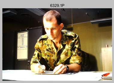
Photograph - Tasks Demonstrated by Royal Australian Survey Corps Technicians, c1990s
... The photos are part of the Army Survey Regiment’s Collection. .1) – Photo, colour, c1992, Aerial photography Assessment, SGT Tony Grivell. .2) – Photo, colour, c1992, Aerial photography Assessment, L to R: WO2 Noel McNamara and LCPL Grant Lloyd. .3) – Photo, colour, c1992, Wild PUG4 point transfer device, LCPL Mark Fedden. .4) – Photo, colour, c1992, AUTOMAP 2 Graphic Edit Workstation, unidentified technician. .5) – Photo, colour, c1992, Heidelberg Speedmaster 102 computer-controlled five colour lithographic offset printing press, CPL Nick Vanderzwan. .6) – Photo, colour, c1992, Daylight film contact frame, SPR Ken Labourchardiere. .7) – Photo, colour, c1992, Heidelberg Speedmaster 102 Map Colour Evaluation Workstation, SGT Stuart Ridge. .8) – Photo, colour, c1992, Map proof evaluation, CPL John Bragg. .9) – Photo, colour, c1992, Wohlenberg MCS-2 guillotine, unidentified technician. .10) – Photo, colour, c1992, Wild T2 Theodolite, L to R: SPR Matt Arnold, SPR Kim Baker. .11) – Photo, colour, c1992, Wild T2 Theodolite, L to R: SSGT Bob Bright, SPR Kim Baker. .12) to .14) – Photo, colour, c1992, MRA-7 Tellurometer, CPL Mark Bourne. .15) – Photo, colour, c1992, Plane Tabling, CPL Mark Bourne. .16) – Photo, colour, c1992, School of Military Survey base camp, Sandy Creek, VIC. .17) – Photo, black & white, 1990, MRA-7 Tellurometer, CPL Steve Nokes. ...The photos are part of the Army Survey Regiment’s Collection. .1) – Photo, colour, c1992, Aerial photography Assessment, SGT Tony Grivell. .2) – Photo, colour, c1992, Aerial photography Assessment, L to R: WO2 Noel McNamara and LCPL Grant Lloyd. .3) – Photo, colour, c1992, Wild PUG4 point transfer device, LCPL Mark Fedden. .4) – Photo, colour, c1992, AUTOMAP 2 Graphic Edit Workstation, unidentified technician. .5) – Photo, colour, c1992, Heidelberg Speedmaster 102 computer-controlled five colour lithographic offset printing press, CPL Nick Vanderzwan. .6) – Photo, colour, c1992, Daylight film contact frame, SPR Ken Labourchardiere. .7) – Photo, colour, c1992, Heidelberg Speedmaster 102 Map Colour Evaluation Workstation, SGT Stuart Ridge. .8) – Photo, colour, c1992, Map proof evaluation, CPL John Bragg. .9) – Photo, colour, c1992, Wohlenberg MCS-2 guillotine, unidentified technician. .10) – Photo, colour, c1992, Wild T2 Theodolite, L to R: SPR Matt Arnold, SPR Kim Baker. .11) – Photo, colour, c1992, Wild T2 Theodolite, L to R: SSGT Bob Bright, SPR Kim Baker. .12) to .14) – Photo, colour, c1992, MRA-7 Tellurometer, CPL Mark Bourne. .15) – Photo, colour, c1992, Plane Tabling, CPL Mark Bourne. .16) – Photo, colour, c1992, School of Military Survey base camp, Sandy Creek, VIC. .17) – Photo, black & white, 1990, MRA-7 Tellurometer, CPL Steve Nokes. ...This is a set of 17 photographs of technicians from the Royal Australian Survey Corps undertaking technical tasks circa 1990s. Photos .1P to .9P were taken at the Army Survey Regiment, Fortuna, Bendigo. Photos .10P to .15P and .17P of students operating survey equipment, were taken at the School of Military Survey, Bonegilla and survey stations surrounding Lake Hume. The base camp at photo .16P was probably taken at Sandy Creek, near Tallangatta Victoria, during the field phase of a basic or advanced RA Svy training course. CPL Steve Nokes appearing in photo .17P was attending the 1/90 Map Control Survey Course.This is a set of 17 photographs of technicians from the Royal Australian Survey Corps undertaking technical tasks at the Army Survey Regiment, Fortuna, Bendigo, and the School of Military Survey, Bonegilla c1992. Colour photos are on 35mm slide film and were scanned at 96 dpi. Photo .17P is in black & white, printed on photographic paper and scanned at 300 dpi. The photos are part of the Army Survey Regiment’s Collection. .1) – Photo, colour, c1992, Aerial photography Assessment, SGT Tony Grivell. .2) – Photo, colour, c1992, Aerial photography Assessment, L to R: WO2 Noel McNamara and LCPL Grant Lloyd. .3) – Photo, colour, c1992, Wild PUG4 point transfer device, LCPL Mark Fedden. .4) – Photo, colour, c1992, AUTOMAP 2 Graphic Edit Workstation, unidentified technician. .5) – Photo, colour, c1992, Heidelberg Speedmaster 102 computer-controlled five colour lithographic offset printing press, CPL Nick Vanderzwan. .6) – Photo, colour, c1992, Daylight film contact frame, SPR Ken Labourchardiere. .7) – Photo, colour, c1992, Heidelberg Speedmaster 102 Map Colour Evaluation Workstation, SGT Stuart Ridge. .8) – Photo, colour, c1992, Map proof evaluation, CPL John Bragg. .9) – Photo, colour, c1992, Wohlenberg MCS-2 guillotine, unidentified technician. .10) – Photo, colour, c1992, Wild T2 Theodolite, L to R: SPR Matt Arnold, SPR Kim Baker. .11) – Photo, colour, c1992, Wild T2 Theodolite, L to R: SSGT Bob Bright, SPR Kim Baker. .12) to .14) – Photo, colour, c1992, MRA-7 Tellurometer, CPL Mark Bourne. .15) – Photo, colour, c1992, Plane Tabling, CPL Mark Bourne. .16) – Photo, colour, c1992, School of Military Survey base camp, Sandy Creek, VIC. .17) – Photo, black & white, 1990, MRA-7 Tellurometer, CPL Steve Nokes. .1P to .16P - There are no annotations. .17P – annotated on back ‘CPL NOKES WITH MRA7 ON 1/90 MAP CONTROL COURSE’royal australian survey corps, rasvy, army survey regiment, army svy regt, school of military survey, fortuna, asr -
 Bendigo Military Museum
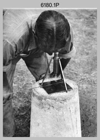
Photograph - RASvy Surveyors in the field, c1950s – 1960s
... The surveyor in photo .13P is cutting an identification blaze on a tree using a hammer and chisel. The tellurometer in Photos .14P to .16P was a MRA1 microwave Electronic Distance Measuring instrument (EDM) introduced in 1958. ...The surveyor in photo .13P is cutting an identification blaze on a tree using a hammer and chisel. The tellurometer in Photos .14P to .16P was a MRA1 microwave Electronic Distance Measuring instrument (EDM) introduced in 1958. ...This is a set of 1photographs of surveyors in the field measuring distances using chains, taking observations using theodolites and operating electric distance measurement equipment. They were probably employed in establishing mapping and geodetic control operations or the surveyors may have been in training. The photos were most likely taken in the 1950s and 1960s. Photos .1P to .6P feature personnel setting up geodetic survey chaining equipment to measure distances. The surveyor in Photo .5P is LTCOL Howard Angus Johnson MBE who served from 1936 to 1954. The RA Svy surveyor in photos .7P to .12P were using a theodolite to take angular measurements. They were usually supported by an observer who recording their readings on a booking form. The surveyor in Photo .10P and .11P is LTCOL Jorge Gruszka, who served from 1955 to 1985. He was CO of the Army Survey Regiment from 1982 to 1985. The surveyor in photo .13P is cutting an identification blaze on a tree using a hammer and chisel. The tellurometer in Photos .14P to .16P was a MRA1 microwave Electronic Distance Measuring instrument (EDM) introduced in 1958. It and later models were man-portable systems that improved geodetic survey efficiencies for rapid network extension and densification replacing triangulation with EDM and theodolite traverse sometimes using Bilby Towers to extend line lengths. The surveyor with the slouch hat is Colonel James ‘Jim’ Leslie Stedman, who served from 1941 to 1978. He was Director of Military Survey from 1975 to 1978 and was appointed as Colonel Commandant (honorary appointment, Retd) of the Royal Australian Survey Corps from 1978 to 1983. Jim Stedman is demonstrating EDM equipment.This is a set of 17 photographs of surveyors in the field measuring distances using chains, taking observations using theodolites and operating electric distance measurement (EDM) equipment. c1950s – 1960s. The photographs were printed on photographic paper and are part of the Army Survey Regiment’s Collection. The photographs were scanned at 300 dpi. .1) - Photo, black & white, c1950s, unidentified personnel using geodetic survey chaining equipment. .2) to .4) - Photo, black & white, c1950s, geodetic survey chaining equipment. .5) – Photo, black & white, c1950s, Jim Stedman using geodetic survey chaining equipment to measure distances. .6) - Photo, black & white, c1950s, Unidentified personnel geodetic survey chaining equipment. .7) – Photo, black & white, mounted on card, c1950s. Unidentified surveyor undertaking observations on a coral reef using a theodolite. .8) – Photo, black & white, c1950, unidentified surveyor undertaking observations with a Tavistock theodolite. .9) – Photo, black & white, mounted on green card, c1950s. Unidentified surveyor undertaking observations using a plane table. .10) – Photo, black & white, c1955, Jorge Gruszka undertaking observations with a theodolite. 7/55 Basic Survey Course Balcombe. .11) – Photo, black & white, c1950s, Jorge Gruszka undertaking observations with a theodolite. .12) – Photo, black & white, c1946-1948, unidentified surveyor undertaking observations with a theodolite to gain control for the mapping of the Snowy Mountain Diversion Scheme. .13) – Photo, black & white, c1950s, unidentified surveyor cutting a blaze in a tree. .14) and .15) – Photo, black & white, c1960s, Jim Stedman demonstrating EDM equipment. .16) – Photo, black & white, c1960s, L to R: Jim Stedman (probably) and unidentified surveyor demonstrating EDM equipment. .17) – Photo, black & white, 1956, Operation Cutlass - Surveyors SPR W. Crane and J.A. Campbell undertaking observations with a theodolite in extreme conditions..1P on back - First Order Chaining Equipment .2P on back - First Order Chaining Equipment .3P on back - Full catenary 1800 – 1960 replaced by EDM .4P on back - First Order Chaining Equipment .5P on back - H.A. Johnson, Benambra baseline? 1st Order Chaining .6P on back - Chaining .7P on front - Difficult observing conditions especially when the tide is in. The station is sighted (sic) on a coral reef. .8P on back - Tavistock. .10P on back of duplicate in Photo Folder 14 – George (sic) Gruszka 7/55 Basic Survey Course Balcomme (sic) 1955/56 .14P and .15P on back - Jim Stedman demonstrating early EDM equipment.royal australian survey corps, rasvy, army survey regiment, army svy regt, fortuna, asr, surveying -
 Bendigo Military Museum
Photograph - Royal Australian Survey Corps Surveyors in the Field – North Queensland, 1958
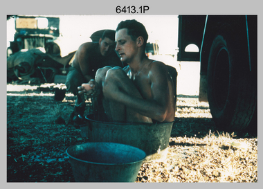
... Surveyors Nth QLD undertaking survey observations, using MRA1 tellurometer to measure base-line distances. L to R: Len Davies, Lou Sommer, John Van De Graff. ...Surveyors Nth QLD undertaking survey observations, using MRA1 tellurometer to measure base-line distances. L to R: Len Davies, Lou Sommer, John Van De Graff. ...This is a set of seven photographs of surveyors and support staff in the field undertaking duties in North Queensland in 1958. The surveyors were employed in the establishment of mapping and geodetic control. In this era surveyors used theodolites to observe horizontal and vertical angles and chains to measure base line distances between survey stations. Bob Skitch shown in photos .4P to .6P was in the 2nd year of his career in the Australian Army. He achieved the rank of Lieutenant Colonel and his last appointment was the CO of the Army Survey Regiment from 1976 to 1980. The annotation on the back of photo .5P ‘Black foreground is where Bob Skitch boiled billy and started a grass fire’.This is a set of seven photographs of surveyors and support staff in the field undertaking duties in North Queensland in 1958. The photographs were printed on photographic paper and are part of the Army Survey Regiment’s Collection. The photographs were scanned at 300 dpi. .1) - Photo, colour, 1958. Surveyor in Nth QLD enjoying a bath. L to R: Don Cocker, Bob Thompson. .2) - Photo, colour, 1958. Don Cocker surveyor in Nth QLD, enjoying a bath. .3) - Photo, colour, 1958. Surveyors Nth QLD undertaking survey observations, using MRA1 tellurometer to measure base-line distances. L to R: Len Davies, Lou Sommer, John Van De Graff. MRA1 was covered to stop overheating. .4) - Photo, colour, 1958. Surveyors south of Richmond, QLD digging holes for the erection of a Bilby observation tower. L to R: John Van De Graff, Bob Skitch, Kev Moody, Mal Hayes, Don Gray .5) - Photo, colour, 1958. Surveyors south of Richmond, QLD erecting a Bilby observation tower. L to R: Tom Royle, Bob Skitch (on ground level), Mal Hayes. .6) - Photo, colour, 1958. Surveyors south of Richmond, QLD erecting a Bilby observation tower. L to R: Tom Royle, Bob Skitch, Mal Hayes, Jim McGill (on ground level). .7) - Photo, colour, 1958. Surveyors south of Richmond, QLD undertaking survey measurements from a Bilby observation tower..1P to .7P annotated on back – personnel names, the year and the location. Annotated on back of .5P ‘Black foreground is where Bob Skitch boiled billy and started a grass fire’.royal australian survey corps, rasvy, army survey regiment, asr, army svy regt, fortuna, surveying -
 Bendigo Military Museum
Photograph - RA Svy Project C4 Aerodist Operation, Eastern Arnhem Land, NT, 1967
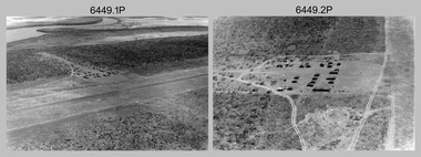
... Aerodist MRC2 was a tellurometer-based system adapted for aircraft to accurately measure distances between non-intervisible ground survey stations, using the aircraft as an intermediate station. ...Aerodist MRC2 was a tellurometer-based system adapted for aircraft to accurately measure distances between non-intervisible ground survey stations, using the aircraft as an intermediate station. ...This is a set of 30 photographs of Royal Australian Survey Corps (RA Svy) personnel from Central Comd Fd Svy Unit (Adelaide) on Aerodist survey operation - Project C4 in Eastern Arnhem Land, Northern Territory in 1967. Photos of personnel were taken either at the operations base at Numbulwar or the main base at Gove (Nhulunbuy). RA Svy conducted nineteen Aerodist operations for 12 years from 1964 to 1975. Aerodist MRC2 was a tellurometer-based system adapted for aircraft to accurately measure distances between non-intervisible ground survey stations, using the aircraft as an intermediate station. Lower order geodetic results could be achieved by survey network trilateration. The measured distances between stations formed survey networks from which each station’s latitude and longitude was computed. Aerodist MRC2 was RA Svy’s major horizontal control survey tool for mainly medium scale topographic mapping (scale 1:100,000 Class A being spatially accurate to within 50 metres) in PNG, northern NT, north-west WA, Kalimantan Barat (West) Indonesia, Sumatra Indonesia, Gulf of Carpentaria and Cape York, QLD. In 1967, the Aerodist MRC2 Master equipment was installed in the aircraft featured in this set of photos, Executive Air Services’ (Essendon VIC) Grand Aero Commander VH-EXX. It was the same aircraft type and company contracted to Division of National Mapping for Aerodist MRC2 surveys. From July to October 1967 the aircraft was attached to Central Comd Fd Svy Unit (Adelaide - Major Don Ridge) on Project C4 eastern-Arnhem Land NT, where 317 Aerodist lines measuring 17,300 line miles were successfully completed. This was the most productive Aerodist project thus far. The most common helicopter used by RA Svy up to 1972 was the civilian Bell 47G-2 and the Sioux Light Observation Helicopters (LOH), the Australian Army’s equivalent featured in this photo set. These light observation helicopters had a limiting load carrying capacity of up to about 500 pounds. By comparison, one Aerodist team including two people weighed up to 1,500 pounds. Source: Royal Australian Survey Corps – Aerodist Years 1964-1975 by Peter Jensen. Refer to Item 9061.26P for more photos taken during this Aerodist survey operation.This is a set of 30 photographs of Royal Australian Survey Corps (RA Svy) personnel on Aerodist survey operations in Eastern Arnhem Land, Northern Territory in 1967. The photographs are on 35mm negative film and scanned at 96 dpi. They are part of the Army Survey Regiment’s Collection. .1) to .4) - black & white, 20th August 1967, Project C4 Aerodist Operations Base - Numbulwar, NT. .5) - Photo, black & white, 1967. Probable wrecked Indonesian fishing vessel. .6) to .8) - Photo, black & white, 1967. Unidentified survey operations base, L to R: unidentified personnel. .9) - Photo, black & white, 1967. Unidentified survey operations base, unidentified soldier driving a Haflinger 4x4 Light utility vehicle. .10) - Photo, black & white, 1967. Unidentified survey operations base, L to R: unidentified technician. .11) - Unidentified technician reading two survey altimeters to compute corrections to the measured distances for atmospheric refraction and to compute the sea level distances from the slope distances aircraft to the ground stations. .12) - Photo, black & white, 1967. Survey operations base, L to R: unidentified (x3), W01 Pat Wood BEM, unidentified. .13) to .16) - Photo, black & white, 1967. Unidentified personnel operating remote Aerodist MRC2 ground instruments. .17) to .18) - Photo, black & white, 1967. Unknown RA Svy office location. .19) to .20) - Photo, black & white, 1967. Aerodist MRC2 Master equipment. .21) to .22) - Photo, black & white, 1967. Aero Commander VH-EXX probably at Gove, NT, Central Comd Fd Svy Unit (Adelaide) – OC Major Don Ridge. .23) to .25) - Photo, black & white, 1967. Aero Commander VH-EXX probably at Gove, NT. Unidentified personnel. .26) - Photo, black & white, 1967. Aero Commander VH-EXX probably at Gove, NT. Aerodist antenna pods are visible on the aircraft. .27) to .29) - Photo, black & white, 1967. Australian Army Sioux Light Observation Helicopter (LOH) probably at Gove, NT. .30) - Photo, black & white, 1967. Panelled U337 survey station, visible as a white cross on aerial identification photo..1P to .2P – date and location on edge of film negative. .5P to .28P – no annotations .29P - annotated in white ‘RW-JEP Gove NT’ .30P - annotated in white ‘U337 Spool No1 Jun67’royal australian survey corps, rasvy, army survey regiment, army svy regt, fortuna, asr, aerodist, surveying, central comd fd svy unit -
 Bendigo Military Museum
Photograph - RA Svy Project C4 Aerodist Operation, Eastern & Western Arnhem Land, NT, 1967, 1968
... Aerodist MRC2 was a tellurometer-based system adapted for aircraft to accurately measure distances between non-intervisible ground survey stations, using the aircraft as an intermediate station. ...Aerodist MRC2 was a tellurometer-based system adapted for aircraft to accurately measure distances between non-intervisible ground survey stations, using the aircraft as an intermediate station. ...This is a set of 26 photographs of Royal Australian Survey Corps (RA Svy) personnel from Central Comd Fd Svy Unit (Adelaide) on Aerodist survey operation - Project C4 in Eastern Arnhem Land, Northern Territory in 1967 (photos .4P to .26P) and in Western Arnhem Land, Northern Territory in 1968 (photos .1P to .3P). Photos of personnel were taken either at the operations base at Numbulwar or the main base at Gove (Nhulunbuy). RA Svy conducted nineteen Aerodist operations for 12 years from 1964 to 1975. Aerodist MRC2 was a tellurometer-based system adapted for aircraft to accurately measure distances between non-intervisible ground survey stations, using the aircraft as an intermediate station. Lower order geodetic results could be achieved by survey network trilateration. The measured distances between stations formed survey networks from which each station’s latitude and longitude was computed. Aerodist MRC2 was RA Svy’s major horizontal control survey tool for mainly medium scale topographic mapping (scale 1:100,000 Class A being spatially accurate to within 50 metres) in PNG, northern NT, north-west WA, Kalimantan Barat (West) Indonesia, Sumatra Indonesia, Gulf of Carpentaria and Cape York, QLD. In 1967, the Aerodist MRC2 Master equipment was installed in the aircraft featured in this set of photos, Executive Air Services’ (Essendon VIC) Grand Aero Commander VH-EXX. It was the same aircraft type and company contracted to Division of National Mapping for Aerodist MRC2 surveys. From July to October 1967 the aircraft was attached to Central Comd Fd Svy Unit (Adelaide - Major Don Ridge) on Project C4 eastern-Arnhem Land NT, where 317 Aerodist lines measuring 17,300 line miles were successfully completed. This was the most productive Aerodist project thus far. The most common helicopter used by RA Svy up to 1972 was the civilian Bell 47G-2 and the Sioux Light Observation Helicopters (LOH), the Australian Army’s equivalent featured in this photo set. These light observation helicopters had a limiting load carrying capacity of up to about 500 pounds. By comparison, one Aerodist team including two people weighed up to 1,500 pounds. In 1968, after completion of the Kimberley Aerodist Operation project, the Aerodist system in VH-EXX was immediately deployed to western-Arnhem Land NT for Central Comd Fd Svy Unit (Adelaide - Major Don Ridge) to complete the mapping control across northern NT from mid-July to October. The Aerodist MRC2 Remote antenna seen in Photos .24P to .26P is mounted on a 20 foot pole tower. The antenna direction was controlled by wires/ropes to the two arms under the dish at right angles. The antenna elevation could be changed to the vertical for aircraft height checks as seen in photo .25P. Source: Royal Australian Survey Corps – Aerodist Years 1964-1975 by Peter Jensen. Refer to Item 6449.30P for more photos taken during these Aerodist survey operations.This is a set of 26 photographs of Royal Australian Survey Corps (RA Svy) personnel on Aerodist survey operations in Eastern Arnhem Land, Northern Territory in 1967 and Western Arnhem Land, Northern Territory in 1968. The photographs are on 35mm negative film and scanned at 96 dpi. They are part of the Army Survey Regiment’s Collection. .1) to .2) – Photo, black & white, 1968, unidentified soldier with an opened can of food, possibly bully beef. .3) – Photo, black & white, 15 Aug 1968, aerial view of terrain taken from a helicopter in vicinity of MILINGIMBI SIERRA. .4) – Photo, black & white, 1967, aerial view of an island taken from a helicopter. .5) & .6) – Photo, black & white, 1967, unidentified soldier driving a Haflinger 4x4 Light utility vehicle with trailer. .7) – Photo, black & white, 1967, unidentified surveyors taking vertical measurements with a leveling instrument and staff. .8) – Photo, black & white, 1967, Australian Army Sioux Light Observation Helicopter (LOH) with float removed. .9) to .11) – Photo, black & white, 1967, Australian Army Sioux Light Observation Helicopter (LOH) with floats. .12) – Photo, black & white, 1967, civilian Bell 47G-2 helicopter (Australian Army Sioux LOH equivalent) refuelled. .13) – Photo, black & white, 1967, survey station on coastline surrounded by white plastic aerial photographic identification panels lined with rocks. .14) & .15) – Photo, black & white, 1967, soldier (possibly a signaller from RA Sigs) operating a radio. .16) – Photo, black & white, 1967, Central Comd Fd Svy Unit Operations Section tent, Main Base Gove (Nhulunbuy) L to R: SPR Harry Dunn, WO1 Pat Wood BEM. .17) – Photo, black & white, 1967, Central Comd Fd Svy Unit Operations Section tent, Main Base Gove (Nhulunbuy) L to R: unidentified, WO1 Pat Wood BEM. .18) – Photo, black & white, 1967, Central Comd Fd Svy Unit Operations Section, Main Base Gove (Nhulunbuy), unidentified Australian Army Catering Corps cook preparing meals. .19) – Photo, black & white, 1967, Central Comd Fd Svy Unit Operations Section, Main Base Gove (Nhulunbuy) mess tent in readiness for meals. .20) – Photo, black & white, 1967, Bank of batteries in transit boxes undergoing recharging using generators. .21) – Photo, black & white, 1967, A topographic survey identification plaque set in a concrete block being weighed using a set of scales hanging from slaughtering gallows. .22) – Photo, black & white, 1967, CPL (Geoff or Gary) Larkin operating the remote Aerodist MRC2 ground instrument at Veronica Island, located north of Nhulunbuy. .23) – Photo, black & white, 1967, L to R: CPL (Geoff or Gary) Larkin with unidentified surveyor operate the remote Aerodist MRC2 ground instrument at Venica Island, located north of Nhulunbuy. .24) & .25 – Photo, black & white, 1967, The Aerodist MRC2 Remote antenna. .26) – Photo, black & white, 1967, The Aerodist MRC2 Remote antenna.The following photos are annotated in black ink on edge of film negative: .3P – ’15 Aug ’68, 2000’, 1-C18 ’68 MILINGIMBI SIERRA’ .4P – ’U462’ .8P – ‘1-C3/67 Float Removed’ .13P – ‘U477 10-C3/67 .20P - ‘2-C3/67 Bank of Chargers’ .21P - ‘3-C3/67 Gallows & Scales’ .22P - ‘0462 VERONICA ISLAND NT, CPL Larkin’ .23P - ‘0462 VERONICA ISLAND NT’ .24P - ‘4-C3/67 20’ Aerodist Tower’ .25P - ‘5-C3/67 20’ Aerodist Tower’ .26P - ‘6-C3/67 20’ Aerodist Tower’royal australian survey corps, rasvy, army survey regiment, army svy regt, fortuna, asr, aerodist, surveying, central comd fd svy unit -
 Bendigo Military Museum
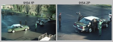
Photograph - Army Survey Regiment – Corps Day Parade Set 2, Fortuna Villa, Bendigo, 1991
... SPR Peter Smyth stands on the corner of the parade ground behind an MRA-7 Tellurometer mounted on a tripod. .15) & .16) - Photo, colour, 1991. ...SPR Peter Smyth stands on the corner of the parade ground behind an MRA-7 Tellurometer mounted on a tripod. .15) & .16) - Photo, colour, 1991. ...This set of 37 photographs was taken at the Corps Day Parade held at the Army Survey Regiment, Bendigo on the 26th of June 1991.The Corps Day Parade was held to commemorate the 76th anniversary of the formation of the Royal Australian Survey Corps. The Reviewing officer was the Commander of the 3rd Military District BRIG P. Davies AM ADC and the Parade Host was D-SVY COL Simon Lemon. Refer to items 9152.31P for more photographs taken during the parade; and 9155.27P for photographs taken afterwards during the tour of the unit and the family BBQ.This is a set of 37 photographs of the Corps Day Parade held at the Army Survey Regiment, Fortuna, Bendigo on the 26th of June 1991. The colour photographs are on 35mm negative film and scanned at 2400 dpi. They are part of the Army Survey Regiment’s Collection. .1) - Photo, colour, 1991. Arrival of COMD 3MD. L to R: D-SVY - COL Simon Lemon, unidentified personnel, unidentified Aide-de-camp. .2) to .4) - Photo, colour, 1991. Arrival of COMD 3MD. L to R: D-SVY - COL Simon Lemon, COMD 3MD - BRIG P. Davies AM ADC, unidentified Aide-de-camp, unidentified personnel. .5) - Photo, colour, 1991. Cartographic Squadron stands at attention, under command of OC MAJ Graeme Wastell. .6) - Photo, colour, 1991. Headquarters Squadron stands at attention, under command of OC MAJ Peter Jensen. 2IC MAJ Ray Redman at left. .7) - Photo, colour, 1991. Air Survey Squadron stands at attention. L to R: LT Simon Buckpitt, WO1 Brett ‘Dutchy’ Van Leeuwen, unidentified (x2), CPL Perry Burt, SGT Sandy Craig, SGT Graeme Reany, SPR Stuart Bowd, LT Michelle Breen in foreground, unidentified, SGT Wolfgang Thun, SSGT Bruce Hammond, unidentified, SGT Paul Hopes, WO1 Russell ‘Rusty’ Williams. .8) - Photo, colour, 1991. Air Survey Squadron at attention under command of OC MAJ Peter Clark - at far left during the inspection. L to R: LT Simon Buckpitt, CO LTCOL Rene van den Tol, unidentified Aide-de-camp, LT Michelle Breen in foreground. At her right L to R: COMD 3MD - BRIG P. Davies AM ADC, SGT Graeme Reany, SPR Stuart Bowd, unidentified, SGT Wolfgang Thun, SSGT Bruce Hammond, unidentified, SGT Paul Hopes, WO1 Russell ‘Rusty’ Williams. .9) - Photo, colour, 1991. Air Survey Squadron inspection. L to R: D-SVY - COL Simon Lemon, COMD 3MD - BRIG P. Davies AM ADC, SPR Steve Linane, SPR Derek Percival. .10) & .11) - Photo, colour, 1991. Air Survey Squadron inspection. SSGT Graham Johnston at far left. L to R: CO LTCOL Rene van den Tol, unidentified Aide-de-camp, D-SVY - COL Simon Lemon, COMD 3MD - BRIG P. Davies AM ADC, SPR John ‘Docc’ Commons, unidentified (x4), SPR Jo (Innes) Thun, SGT Peter Tuddenham, SSGT Bob Garritty, SGT Martin Evans. .12) - Photo, colour, 1991. Air Survey Squadron inspection. L to R: CO LTCOL Rene van den Tol, unidentified Aide-de-camp, D-SVY - COL Simon Lemon, COMD 3MD - BRIG P. Davies AM ADC, SPR John ‘Docc’ Commons, unidentified (x4), SPR Jo (Innes) Thun, SGT Peter Tuddenham, SSGT Bob Garritty, SGT Martin Evans. Unidentified WO2 in right background. .13) & .14) - Photo, colour, 1991. SPR Peter Smyth stands on the corner of the parade ground behind an MRA-7 Tellurometer mounted on a tripod. .15) & .16) - Photo, colour, 1991. SPR Damian Nolan stands on the corner of the parade ground behind a Plane Table Board with an alidade mounted 3MD Band stands at attention during the inspection. L to R: unidentified Aide-de-camp, unidentified 3MD Band Master, D-SVY - COL Simon Lemon, COMD 3MD - BRIG P. Davies AM ADC, unidentified members of 3MD Band.on a tripod. .17) - Photo, colour, 1991. The unidentified 3MD Band Master salutes COMD 3MD - BRIG P. Davies AM ADC before the 3MD Band inspection. .18) - Photo, colour, 1991. 3MD Band stands at attention during the inspection. L to R: unidentified Aide-de-camp, unidentified 3MD Band Master, D-SVY - COL Simon Lemon, COMD 3MD - BRIG P. Davies AM ADC, unidentified members of 3MD Band. .19) - Photo, colour, 1991. Army Survey Regiment at ‘Shoulder Arms’ position in readiness for the Present Arms’ salute. CO LTCOL Rene van den Tol at front. .20) - Photo, colour, 1991. Cartographic and Air Survey Squadrons at ‘Shoulder Arms’ position in readiness for the Present Arms’ salute. CO LTCOL Rene van den Tol at front. .21) - Photo, colour, 1991. Headquarters Squadron at ‘Shoulder Arms’ position in readiness for the Present Arms’ salute. L to R: 2IC MAJ Ray Redman, MAJ Bob Williams, OC MAJ Peter Jensen. CAPT Colin Cuskelly. .22) & .23) - Photo, colour, 1991. Army Survey Regiment under CO LTCOL Rene van den Tol’s command salutes the COMD 3MD with ‘Present Arms’. .24) - Photo, colour, 1991. L to R: COMD 3MD - BRIG P. Davies AM ADC, D-SVY - COL Simon Lemon, unidentified Aide-de-camp. .25) - Photo, colour, 1991. The squadrons remove their hats in readiness for ‘Three cheers for Her Majesty the Queen’. .26) & .27) - Photo, colour, 1991. The squadrons cheer in unison to the command ‘Three cheers for Her Majesty the Queen’. .28) - Photo, colour, 1991. The unidentified padre addresses the Parade. .29) - Photo, colour, 1991. COMD 3MD - BRIG P. Davies AM ADC, addresses the Parade. .30) - Photo, colour, 1991. D-SVY - COL Simon Lemon addresses the Parade. .31) & .32) - Photo, colour, 1991. COMD 3MD - BRIG P. Davies AM ADC presents the Defence Force Service Medal with clasp to WO1 Brett ‘Dutchy’ Van Leeuwen for 20 years of efficient remunerated service. .33) - Photo, colour, 1991. The 3MD Band marches towards the front steps of Fortuna Villa. .34) - Photo, colour, 1991. The 3MD Band salutes as it marches past the official guests on the front steps of Fortuna Villa. .35) - Photo, colour, 1991. Lithographic Squadron led by OC MAJ Bob Coote marches towards the front steps of Fortuna Villa. .36) - Photo, colour, 1991. Lithographic Squadron led by OC MAJ Bob Coote salutes as it marches past the official guests on the front steps of Fortuna Villa. .37) - Photo, colour, 1991. COMD 3MD - BRIG P. Davies AM ADC salutes the passing troops. L to R: D-SVY - COL Simon Lemon, unidentified UK Liaison Officer, BRIG P. Davies AM ADC, unidentified Aide-de-camp.There are no personnel identified. ‘Corps Day 26 Jun 1991’ annotated on negative sleeves.royal australian survey corps, rasvy, army survey regiment, army svy regt, fortuna