Showing 79 items matching "the engineer's view"
-
 Moorabbin Air Museum
Book - DOUGLAS DC-3 DAKOTA, Douglas DC-3 Dakota Owners Workshop Manual
... ...The crew's view...The engineer's...Douglas DC-3 Dakota The Dakota story Anatomy of the Dakota The Pratt & Whitney R-1830-90D The owner's view The crew's view The engineer's view Overview on history & maintenance of DC3 Dakota, circa 2011 Douglas DC-3 Dakota Owners Workshop Manual Book DOUGLAS DC-3 DAKOTA ...Overview on history & maintenance of DC3 Dakota, circa 2011non-fictionOverview on history & maintenance of DC3 Dakota, circa 2011the dakota story, anatomy of the dakota, the pratt & whitney r-1830-90d, the owner's view, the crew's view, the engineer's view -
 Glenelg Shire Council Cultural Collection
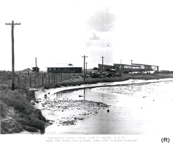
Photograph - Photograph - Portland Harbour Trust - Engineer's office from Cliff St Bridge, 1952
... View of Engineer's office from Cliff St Bridge...Front: ENGINEER'S OFFICE FROM CLIFF ST. BRIDGE 5.11.52/ View showing Model Shed, Storage fence & 3 phase power supply/ in course of erection. ...No 34/ Date taken 5-11-52/ SUBJECT./ % (Ink stamp with blue pen and pencil additions, centre) View of Engineer's office from Cliff St Bridge Photograph Photograph - Portland Harbour Trust - Engineer's office from Cliff St Bridge Portland Harbour Trust ...Port of Portland Authority archivesFront: ENGINEER'S OFFICE FROM CLIFF ST. BRIDGE 5.11.52/ View showing Model Shed, Storage fence & 3 phase power supply/ in course of erection. (lower centre) Back: P.H.T./ Print No. 3/11 Neg. No 34/ Date taken 5-11-52/ SUBJECT./ % (Ink stamp with blue pen and pencil additions, centre)port of portland archives -
 Glenelg Shire Council Cultural Collection
Photograph - Photograph - Portland Harbour Trust - View of Engineer's Office from Cliff St Bridge, 1952
... View of Engineer's Office from Cliff St Bridge...ENGINEER'S OFFICE FROM CLIFF ST. BRIDGE 4.12.52/MODEL SHED, STORES FENCE & 3 PHASE POWER SUPPLY IN COURSE OF ERECTION (lower centre) Back: P.H.T./ Print No. 3/12 Neg. No 83/ Date taken 4-12-52/ SUBJECT./ % (Ink stamp with blue pen and pencil additions, centre) View of Engineer's Office from Cliff St Bridge Photograph Photograph - Portland Harbour Trust - View of Engineer's Office from Cliff St Bridge Portland Harbour Trust ...Port of Portland Authority archivesFront: ENGINEER'S OFFICE FROM CLIFF ST. BRIDGE 4.12.52/MODEL SHED, STORES FENCE & 3 PHASE POWER SUPPLY IN COURSE OF ERECTION (lower centre) Back: P.H.T./ Print No. 3/12 Neg. No 83/ Date taken 4-12-52/ SUBJECT./ % (Ink stamp with blue pen and pencil additions, centre)port of portland archives -
 Kiewa Valley Historical Society
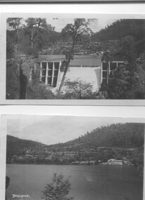
Two black and white photos, Photo downstream view of Junction Dam Wall and photo of Bogong Village and Lake Guy, c1950
... engineer. Shows the type of terrain where the village is located resulting in the tiered layout that was necessary in order to erect housing. Bogong Village Lake Guy SECV Photo No. 1 - Upper right hand corner, back of photo, handwritten in ink or biro, Bogong 1950 Photo No. 2 - Left lower corner, front of photo in white, Bogong. set of 2 black and white photos - Photo No. 1 - downstream view of Junction Dam Wall Photo No. 2 - Lake Guy and Bogong Village. ...Photo No. 1 - Junction Dam wall was commenced in February, 1940 and completed in March 1944. Type - reinforced concrete slab and buttress. Height 25.9m, and crest length 121.9m. Lewis Construction company had the original contract, but was replaced by the State Electricity Commission in 1942. Photo No. 2 - Bogong Village was the first village built to house workers and their families working on the Hydro electric scheme. Construction commenced 1940. The single men's quarters are slightly right of centre on the foreshore. Lake Guy was named after a former resident engineer.Shows the type of terrain where the village is located resulting in the tiered layout that was necessary in order to erect housing.set of 2 black and white photos - Photo No. 1 - downstream view of Junction Dam Wall Photo No. 2 - Lake Guy and Bogong Village. Both are on photographic paperPhoto No. 1 - Upper right hand corner, back of photo, handwritten in ink or biro, Bogong 1950 Photo No. 2 - Left lower corner, front of photo in white, Bogong.bogong village, lake guy, secv -
 Kiewa Valley Historical Society
Photograph - Folder of Photographs – Photocopied set of black and white photographs (pages 39 - 48) from the display folder put together by KVHS to document life on the Kiewa Valley Hydro-electric Scheme
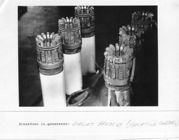
... It is a circuit breaker Signed Ron White Ron was the Principal Hydro Engineer of the SEC Kiewa Scheme Page number 39 2-Big Hill Bench – Site of No. 5 Development (abandoned) Page number 40 3-No 1 Power Station Page number 41 4-No. 1 Pipeline, Anchor No. 8 Page number 42 5-Push Dozing – RD8 Tractor, 12 cubic yard Carryall and FD Cletrac Tractor Page number 43 6-No marking Page number 44 7-No marking Page number 45 8-Journal of State Electricity Commission of Victoria SEC Vol 15 No… April-May, 19… No 1 Pipeline-A view from McKay Portal G Hempenstall and D Sutton stiffening pipe section for transport during construction (….indicates missing text) Page Number 46 9-Rocky Valley Dam Core Wall Page number 47 10-No markings Page number 48 ...It is a circuit breaker Signed Ron White Ron was the Principal Hydro Engineer of the SEC Kiewa Scheme Page number 39 2-Big Hill Bench – Site of No. 5 Development (abandoned) Page number 40 3-No 1 Power Station Page number 41 4-No. 1 Pipeline, Anchor No. 8 Page number 42 5-Push Dozing – RD8 Tractor, 12 cubic yard Carryall and FD Cletrac Tractor Page number 43 6-No marking Page number 44 7-No marking Page number 45 8-Journal of State Electricity Commission of Victoria SEC Vol 15 No… April-May, 19… No 1 Pipeline-A view from McKay Portal G Hempenstall and D Sutton stiffening pipe section for transport during construction (….indicates missing text) Page Number 46 9-Rocky Valley Dam Core Wall Page number 47 10-No markings Page number 48 Large A3 size spiral bound display folder containing photocopied black and white photographs of various aspects of the early days of the Kiewa Valley Hydro-electric scheme including equipment, various work sites and photographs of workers and their families. 1-Breakdown in Circuit Breaker (Isolating Contacts) 2-Big Hill Bench- Site of No 5 Devlopment 3-No 1 Power Station 4-No 1 Pipeline, Anchor No 8 5-Push Dozing-RD8 Tractor 6- Tractor and driver at work 7- Workmen in unnamed tunnel 8- Front page of Journal of SECV Vol 15. ...Although the Kiewa Hydro-Electric Scheme was first proposed in 1911, construction did not commence until 1938. As part of the push to cut electricity costs and diversify supply, the Victorian Government (circa 1930) initiated the conversion from primarily brown coal supply to hydro – electricity. Field investigations during the 1940’s resulted in a new proposal for a scheme that had more than double the capacity of the 1938 scheme. The Kiewa Hydroelectric Scheme became the largest scheme of its kind in the State Of Victoria and the second largest scheme in Australia. The number of personnel involved in the planning and construction of the scheme increased dramatically. During the late 1940’s, most activity centered around the construction of the West Kiewa Power Station, Rocky Valley Reservoir, McKay Creek Power Station and the Bogong Creek Aqueduct.A common thread across all the larger hydro scheme constructions was the need for workers, both qualified and unqualified who came from around the world seeking a new life for themselves and their families. New accommodation and facilities were required for the army of workers engaged in construction in often remote and wild areas. The SEC had a high demand for timber, and set up the first of a number of sawmills at Bogong Creek in 1939 and set up the first hardwood logging in the headwaters of the Kiewa River. These new ‘towns’ such as Mt Beauty and Bogong, survived, serving the needs of operational personnel and their families, and expanding with growth of new industries. Mount Beauty, and to a lesser extent Bogong, are among these places. Large A3 size spiral bound display folder containing photocopied black and white photographs of various aspects of the early days of the Kiewa Valley Hydro-electric scheme including equipment, various work sites and photographs of workers and their families. 1-Breakdown in Circuit Breaker (Isolating Contacts) 2-Big Hill Bench- Site of No 5 Devlopment 3-No 1 Power Station 4-No 1 Pipeline, Anchor No 8 5-Push Dozing-RD8 Tractor 6- Tractor and driver at work 7- Workmen in unnamed tunnel 8- Front page of Journal of SECV Vol 15. Photograph of No 1 pipeline viewed from McKay Portal 9-Rocky Valley Dam Core Wall 10-Workmen working inside tunnel loading rocks into a rail truck. 1-Breakdown in (generator) Circuit Breaker (Isolating Contacts) Handwritten underneath (This is not a picture of any part of a generator. It is a circuit breaker Signed Ron White Ron was the Principal Hydro Engineer of the SEC Kiewa Scheme Page number 39 2-Big Hill Bench – Site of No. 5 Development (abandoned) Page number 40 3-No 1 Power Station Page number 41 4-No. 1 Pipeline, Anchor No. 8 Page number 42 5-Push Dozing – RD8 Tractor, 12 cubic yard Carryall and FD Cletrac Tractor Page number 43 6-No marking Page number 44 7-No marking Page number 45 8-Journal of State Electricity Commission of Victoria SEC Vol 15 No… April-May, 19… No 1 Pipeline-A view from McKay Portal G Hempenstall and D Sutton stiffening pipe section for transport during construction (….indicates missing text) Page Number 46 9-Rocky Valley Dam Core Wall Page number 47 10-No markings Page number 48 secv; kiewa hydro electric scheme; construction area; power stations; reservoirs; aqueduct; mt beauty; bogong -
 Bendigo Military Museum
Photograph - Johnson Ground Elevation Meter (JGEM) Survey Vehicle - Army Survey Regiment, Fortuna, Bendigo, c1960s
... Engineers in 1996, the JGEM vehicle with the Survey Corps collection was donated to its museum. It is believed to be the last of the original manufactured fleet in existence. The JGEM has undergone extensive refurbishment to achieve roadworthiness and is currently housed at The Australian Army Museum of Military Engineering, Hoslworthy Barracks, NSW. It can be viewed...Engineers in 1996, the JGEM vehicle with the Survey Corps collection was donated to its museum. It is believed to be the last of the original manufactured fleet in existence. The JGEM has undergone extensive refurbishment to achieve roadworthiness and is currently housed at The Australian Army Museum of Military Engineering, Hoslworthy Barracks, NSW. It can be viewed ...This is a set of 16 photograph of the Royal Australian Survey Corps’ Johnson Ground Elevation Meter (JGEM) Survey Vehicle taken at the Army Survey Regiment, Fortuna, Bendigo. The JGEM vehicle was extensively used by RA Svy within Australia from the late 1960s. A limited number of Ground Elevation Meter (GEM) station wagon type vehicles were manufactured by General Motors Corporation (GMC) in the USA for the United States Geological Survey, Canada’s mapping agencies, RA Svy and National Mapping (Natmap). The GEM was a four-wheel drive, four-wheel steer vehicle. Four-wheel steering was necessary to avoid systematic errors caused by non-tracking of front and rear wheels on conventionally steered vehicles. The manufacturer substituted the rear axle with a front axle and connected them to form the four-wheel steering mechanism. The two Australian GEM vehicles, referred to as Johnson GEMs (JGEMs) were converted into right-hand drive. After delivery in 1964, acceptance Natmap and RA Svy testing and operator training was undertaken at the Army's School of Military Survey located at Balcombe, Victoria. A small fifth wheel was mounted on a cantilever arm suspension midway between the front and rear wheels on the right side of the vehicle. It was lowered to and raised from its operating position by use of a constant pressure air cylinder. A telescopic bar, suspended between the front and rear axles, provided the reference datum for the angle measurement. The wheel provided the velocity or distance signal through a pulse generator system. A sensitive pendulum mounted on this bar provided the angle measurement for each minute distance traversed. The JGEM contained electromechanical instruments used to determine relative elevations, by trigonometric principles, along a traversed path. These relative elevations were obtained through apparatus which measures the instantaneous angle of inclination of the road and the instantaneous velocity of the meter along such a path. Road routes over which the JGEM operated were planned so that each started and ended as near as practicable to an existing point of known elevation (formally referred to as a level traverse bench mark). The difference in height from the bench mark and the road surface alongside the JGEM’s fifth wheel was measured with a level and staff. Along each route, mapping control photo reference points where new elevation values were required were identified on aerial photographs. Under favourable conditions it was possible to survey as much as 160km in an ordinary working day. The first of RA Svy’s JGEM operations was undertaken in 1:250,000 scale map areas of Queensland. CPL John Hook was the JGEM’s main operator in the early 1970s undertaking operations covering 1:250,000 scale map blocks over northern Victoria and central NSW, each requiring 36 points (9 runs of photography and 4 points across. SPR Lyn Thompson and SPR Bob McDonagh teamed with CPL Hook on some of these JGEM operations. When RA Svy was integrated into the Royal Australian Engineers in 1996, the JGEM vehicle with the Survey Corps collection was donated to its museum. It is believed to be the last of the original manufactured fleet in existence. The JGEM has undergone extensive refurbishment to achieve roadworthiness and is currently housed at The Australian Army Museum of Military Engineering, Hoslworthy Barracks, NSW. It can be viewed by making an appointment with the museum’s curator.This is a set of 16 photograph of the Royal Australian Survey Corps’ Johnson Ground Elevation Meter (JGEM) Survey Vehicle taken at the Army Survey Regiment, Fortuna, Bendigo. The photographs were on 35mm slide film and were scanned at 96 dpi. They are part of the Army Survey Regiment’s Collection. .1) - Photo, colour, c1960s, Johnson Ground Elevation Meter (JGEM) Survey Vehicle .2) - Photo, colour, c1960s, JGEM instrumentation, on-board computer. .3) - Photo, colour, c1960s, JGEM instrumentation. .4) - Photo, colour, c1960s, JGEM instrumentation, on-board computer. .5) - Photo, colour, c1960s, JGEM tyre pressure controller .6) - Photo, colour, c1960s, JGEM rear doors, SGT Geoff Briggs. .7) - Photo, colour, c1960s, JGEM 5th wheel distance/angle measurement device in lowered position, SGT Geoff Briggs. .8) - Photo, colour, c1960s, JGEM 5th wheel distance/angle measurement device in lowered position. .9) & .10) - Photo, colour, c1960s, JGEM tyre pressure system, SGT Geoff Briggs. .11) - Photo, colour, c1960s, JGEM tyre pressure system. SGT Geoff Briggs. .12) - Photo, colour, c1960s, JGEM levelling scope, levelling staff, unidentified technicians. .13) & .14) - Photo, colour, c1960s, JGEM levelling scope, unidentified technician. .15) & .16) - Photo, colour, c1960s, probably survey operation adjusted height plotted on block base sheet. .1P to .16P - Some of the equipment is annotated on the frame of the 35mm slides.royal australian survey corps, rasvy, army survey regiment, army svy regt, fortuna, asr, surveying -
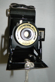 Kiewa Valley Historical Society
Camera Box Brownie Folding, Six 20 Folding Brownie KodetteII, Circa 1948 to late 1970s
... Ironically, one of Kodak's engineers called Steve Sasson, devised a camera that could save images using electronic circuits. The images were transferred onto a tape cassette and were viewable by attaching the camera to a TV screen, however Kodak tried to maintain its photographic film products beyond its "use by date". ...Ironically, one of Kodak's engineers called Steve Sasson, devised a camera that could save images using electronic circuits. The images were transferred onto a tape cassette and were viewable by attaching the camera to a TV screen, however Kodak tried to maintain its photographic film products beyond its "use by date". ...This camera was made for the mobile photographer and the camera manufacturer Kodak was at the peak of production. Mr. George Eastman, the company's founder, who invented roll film, which could withstand the outdoor activities and therefor replaced photographic plates. In 1900, the Box Brownie camera was first released Kodak's motto was' "You push the button, we do the rest," The film used in this camera was Kodak Verichrome 620 introduced in 1936 and only went out of production 2009. This camera was a vintage 1970s one. Between 1963 and 1970 the company sold 50 million of this type of camera. The production of smaller and more user friendly digital cameras, mainly from Japan finally nailed the coffin lid on the Kodak Company. Ironically, one of Kodak's engineers called Steve Sasson, devised a camera that could save images using electronic circuits. The images were transferred onto a tape cassette and were viewable by attaching the camera to a TV screen, however Kodak tried to maintain its photographic film products beyond its "use by date". In1975 Kodak becomes the first company to make a digital camera, however the Japanese manufacturers could make smaller and more compact cameras ending Kodak's monopoly and eventual demise.This particular "box brownie" was used by Margaret Shefford, nee Turner, who with her husband retired, in the 1980s, to Mount Beauty. The camera was purchased in the 197's and used on their cruise to England. The significance of this item is that at the time of its introduction to Mount Beauty the camera was a "state of the art", for general public, camera introduced by an ever increasing influx of retirees. This identifies the Kiewa Valley not only as an attraction for sightseers and overseas tourists but also retirees. The social implications of this trend will continue to provide a broader requirement for medical and other facilities geared up to the requirements of an aging population. As a lot of cities in Australia have increasing levels of violence (mainly drug related) rural "retreats" are becoming more sought after by sections of "the gentle populous"This is a black metal rectangular camera, rounded on the ends and has silver colored fittings(stainless steel) and a small leather handle on hinges the left side (facing the lens). The folding lens and shutter component fold out from the main compartment. Two metal arms swing out and hold the lens and collapsible lens body to the required length. When not in use this collapsible (folding) lens extension is fastened to the main body structure providing security and preventing damage to the folding material. The camera has a collapsible eye piece or view finder at the top end. The right hand bottom end has a cylindrical film wider (polished steel). Inside there are two cylindrical cavities, one holding the roll of unexposed film and the other (winder) end a cylinder onto which the unexposed film is wound through for each picture frame. There is a locking mechanism to hold the folding lens structure to the main box structure. See KVHS 0419B for its carrying caseNo external makings but when the lens is folded out it exposes manufacturing information on metal base around the lens " Kodette II B I shutter"(B= Bulb and I= Instant), underneath this, in larger print, is "'FOLDING 'BROWNIE' SIX - 20" below the lens and in smaller print, "made in Great Britain" and underneath this "by KODAK ltd"kodak kodette ii, folding brownie camera, photography, hobby personal item, tourist gadgets. -
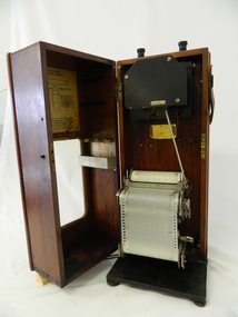 Kiewa Valley Historical Society
Meter Ammeter Recorder, Circa 1950
... On the front of the access "door" at the top a metal label "RECORDING AMMETER" below this "MURDAY SYSTEM" below this "ALTERNATING CURRENT" and below this the manufacturer's registered number "No. 139156" Below this is a metal tag with State Electricity Commission of Victoria Electrical Engineer's Section equipment number "338" Below these tags and above the viewing window is the manufacturer's dtails "EVERSHED & VIGNOLES Led LONDON"...The testing of the SEC Vic supplied electricity to rural properties,those who had previously run on generators, had to be quick and unassuming with certainty of correct supply levels. sec vic kiewa hydro scheme alternate energy supplies alpine feasibility studies temperature rainfall power outages On the front of the access "door" at the top a metal label "RECORDING AMMETER" below this "MURDAY SYSTEM" below this "ALTERNATING CURRENT" and below this the manufacturer's registered number "No. 139156" Below this is a metal tag with State Electricity Commission of Victoria Electrical Engineer's Section equipment number "338" Below these tags and above the viewing window is the manufacturer's dtails "EVERSHED & VIGNOLES Led LONDON" The mechanism of this voltage recorder has been installed(by the manufacturer) into its own protective wooden box. ...This testing voltmeter recorder was last certified by SEC Vic laboratories on the 17/4/77. It was used extensively as mobile recorder placed for periods of one month at locations experiencing unacceptable fluctuations of power. These locations would cover the North East regions of Victoria. They cover voltage drops at domestic and business properties especially those that were experiencing regular fluctuations(daily) at approximately the same time of the day. As the electrical network is required to operate within a set level of voltage, fluctuations outside of this has to be investigated and necessary remedial action taken. This is especially so for rural properties where power "drainage" can occur through animal/bird and tree interference. It can also be the result of defective wiring and overloading at peek operational times (milking machines).This mobile voltage recorder is very significant to the Kiewa Valley because it highlights the difficulties that can occur in maintaining a power supply that experiences fluctuating power demands by the rural industries that it supplies. The requirement of a mobile testing apparatus to cover the various sections in the Kiewa Valley and other rural areas in the northeast region is one of necessity as electricity once connected to a rural property is a labour saving supply as generators on rural properties require a higher degree of maintenance an ultimately at a higher cost. The testing of the SEC Vic supplied electricity to rural properties,those who had previously run on generators, had to be quick and unassuming with certainty of correct supply levels.The mechanism of this voltage recorder has been installed(by the manufacturer) into its own protective wooden box. This box has a front (swing open) lockable section which permits direct access to the installed measuring equipment (for servicing and data collection). The top section of the box has two screw on terminals for access to the machine being tested. This tester has its own inbuilt ink supply facilities and a mechanical clockwork device that unwinds a roll of paper onto a second roll at a rate of 10 mm per hour. The recording chart is marked with time slots against voltage. There is a recording arm which has an ink pen at the end. Both arm and pen carry the ink supply from the ink reservoir, located on the left side of the cabinet door in specially constructed bottle holder( three small bottle capacity). To record a suspect power problem to a home or business establishment the voltmeter is connected to a power supply outlet being tested and wind the recording clockwork mechanism (gives a four week running time). Before leaving the recorder in situ the electrician checks to see if the chart is recording the correct voltage and that the clock mechanism is advancing correctly.On the front of the access "door" at the top a metal label "RECORDING AMMETER" below this "MURDAY SYSTEM" below this "ALTERNATING CURRENT" and below this the manufacturer's registered number "No. 139156" Below this is a metal tag with State Electricity Commission of Victoria Electrical Engineer's Section equipment number "338" Below these tags and above the viewing window is the manufacturer's dtails "EVERSHED & VIGNOLES Led LONDON"sec vic kiewa hydro scheme, alternate energy supplies, alpine feasibility studies temperature, rainfall, power outages -
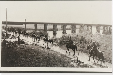 Lara RSL Sub Branch
Photograph, Set 4 photographs. and others for Torquay Light Horse camp, 1940
... view plaque) The plaque identifies a significant event in Torquay’s history and the sentiments of ‘change’ for the Light Horse Brigade – from horses to machines. In 1940 the four Light Horse Regiments (4th, 8th, 13th and 20th), some 5000 Light Horse and 2000 horses camped and trained at Torquay. Three other regiments, formerly mounted on horses, were also at Torquay ‘mounted’ on privately owned trucks and cars. Division troops included Artillery, Engineers...view plaque) The plaque identifies a significant event in Torquay’s history and the sentiments of ‘change’ for the Light Horse Brigade – from horses to machines. In 1940 the four Light Horse Regiments (4th, 8th, 13th and 20th), some 5000 Light Horse and 2000 horses camped and trained at Torquay. Three other regiments, formerly mounted on horses, were also at Torquay ‘mounted’ on privately owned trucks and cars. Division troops included Artillery, Engineers ...These images capture for all time Light Horsemen travelling through Geelong on their way to camp at Torquay for the last Group meeting in Australia . information following - details obtained from .........https://torquayhistory.com/light-horse-brigade/ On Australia Day, 1997, Sir John Young unveiled this plaque on Point Danger, Torquay. Torquay history, Light Horse Training Camp, WW2 Plaque at Pt. Danger Note----- (See images to view plaque) The plaque identifies a significant event in Torquay’s history and the sentiments of ‘change’ for the Light Horse Brigade – from horses to machines. In 1940 the four Light Horse Regiments (4th, 8th, 13th and 20th), some 5000 Light Horse and 2000 horses camped and trained at Torquay. Three other regiments, formerly mounted on horses, were also at Torquay ‘mounted’ on privately owned trucks and cars. Division troops included Artillery, Engineers, Signals, Field Ambulance and other branches of the Army necessary to enable a Division to function. It wasn’t just the sheer numbers of men coming to this little town that made the event significant, it was also the fact that the men of the Light Horse were dramatic, almost glamorous figures and it is easy to see their exploits as some splendid adventure. Horses have played a special role in the story of Australia. They were the only means of transport across this huge country, so it was necessary for everyone to have the ability to ride a horse. When war broke out in 1899 between Britain and the Boers of South Africa (“Boer” was Dutch for “farmer”) Australia sent troops to fight. At first Britain was wary of using untried, unprofessional colonial cavalrymen but soon saw that the slouch-hatted Australian “bushmen” were a match for the fast-moving and unconventional mounted commandos of the Boers. The Australians proved themselves to be expert rough-riding horsemen and good shots. Bush life had hardened them to go for long periods with little food and water. They also showed remarkable ability to find their way in a strange country and use its features for cover, in both attack and defence. By 1914, when Australia joined the war against Germany, there were 23 Light Horse regiments of militia volunteers. Many men from these units joined the Light Horse regiments of the Australian Imperial Force (AIF). Men were given remounts (if not using their own horses) – army horses bought by Commonwealth purchasing officers from graziers and breeders. These were called “walers” because they were a New South Wales stockhorse type – strong, great-hearted animals with the strains of the thoroughbred and semi-draught to give them speed, strength and stamina. On 1st November, 1914, Australia’s First Infantry Division and the first four Light Horse regiments sailed for England in a fleet of transport ships. The first of the Light Horse arrived at Gallipoli in May without their horses. Back with their horses after Gallipoli, they were formidable combatants across the Sinai and Palestine. Some British commanders observed that the light horseman moved with a “lazy, slouching gait, like that of a sleepy tiger” but described how the promise of battle “changes that careless gait, into a live athletic swing that takes him over the ground much quicker than other troops”. They had Light Horse, Torquay, training campdeveloped a reputation as formidable infantrymen. The Turks called them “the White Ghurkas” – a reference to their deadly skill with the bayonet. The Arabs called them “The Kings of the Feathers”. The plume had originally been a battle honour of the Queensland Mounted Infantry for their work in the shearer’s strike of 1891. During WW1 it was adopted by almost all the Light Horse Regiments. It was the proud badge of the light horseman. The most famous of their battles was the attack on Beersheba- the charge of the 4th Light Horse Brigade. Mounted infantrymen and their superb walers had carried out one of the most successful cavalry charges in history – against what seemed impossible odds. They surprised the Turks by charging cavalry-style, when they would normally have ridden close to an objective then dismounted to fight. The fall of Beersheba swung the battle tide against the Turks in Palestine; and changed the history of the Middle East. While 19 men from the Surf Coast Shire served with the 4th Light Horse over the course of WW1, only four were involved in the charge of Beersheba- John GAYLARD, Philip QUINN.(Winchelsea); Wallace FINDLAY (Anglesea); Harry TRIGG (Bambra). After the war, Light Horse units played a key role in the Australian Government’s compulsory military training programme. The Citizen Military Forces (C.M.F.) thrived on the glamour of the wartime Light Horse tradition, ignoring the possibility that motor vehicles would soon replace the horses. When training was no longer compulsory, the C.M.F. regiments declined and horses became more of a luxury during the 1930s depression years of poverty and unemployment. Some regiments were motorised. Then, in 1939, Australia joined Britain in another world war. Training was increased for the militia at both home bases and regional training camps. The camp at Torquay in 1940, commanded by Major General Rankin, was at Divisional strength. By the end of the camp some felt that the Division was ready for active service. Gradually, over the next four years, the Australian Light Horse units were mounted on wheels and tracks and the horses were retired. Six men enlisted at the Torquay camp and another 57 men and women enlisted at Torquay for service in WW2. Those who served in the Militia provided valuable Officers and NCOs and men for the armed services during the war. Each infantry division of the 2nd AIF had a Light Horse regiment attached to it. But the day of the Australian mounted soldier hadn’t quite passed. During World War II, Australia’s 6th Cavalry Regiment formed a mounted unit they called “The Kelly Gang” which did valuable scouting work. In New Guinea, a mounted Light Horse Troop did patrol duty and helped carry supplies. Some fully equipped walers were flown into Borneo for reconnaissance in rugged mountain country. But by the end of the war, in 1945, the horse had disappeared from the Australian Army. References: Australian Light Horse Association www.lighthorse.org.au National Australia Archives Australian War Memorial Surf Coast Shire WW1 memorials www.togethertheyserved.com The Light horse- a Cavalry under Canvas Light Horse, Training Camp, Torquay, WW2 Late in 1939 it was decided to set up a Lighthorse training camp in Torquay to train both men and horses for the battles of the Second World War. Horses, men and equipment came on special trains from all over Victoria and NSW, and as you would expect horseman came from areas such as Omeo and Sale, the Wimmera and the Western District. They arrived at the Geelong racecourse for watering in the Barwon River and then were ridden across the ford at the breakwater and began their 11 mile trek to Torquay. Light Horse, Training Camp, Torquay, WW2 Tent city By the end of January 1940 the camp at Torquay accommodated some 5000 men and 2500 horses of the Second Cavalry Division. The rows of horses, tents and huts near Blackgate Road were quite a sight. While the cavalrymen engaged in exercises on the land and on the beaches, many of the troops took over the Torquay School for special training of men and officers. Mr Bob Pettit local farmer and Councillor for the Barrabool Shire, wrote about the Light horse in the Surf Coast Community News in 1985 saying “They used to travel about the district riding four abreast in one long convoy. To my annoyance they went through my property and shut all the gates behind them. I had certain gates open to let stock in to the water holes and it would take me three -quarters of an hour to follow the horsemen up and put all the gates right again” he continued “the men from the Light Horse were here when the fire went through in March 1940. He recalled an incident when early one morning, as some one blew the bugle, a soldier putting a white sheet on the line frightened the horses. They panicked and ran off in all directions. Six went over the cliff near Bird Rock, five were never found, and the rest were gathered up after nearly a fortnight in the bush around Addiscott and Anglesea" Light Horse, Training Camp, Torquay, WW2, Geelong Parade Geelong parade The training camp culminated in a parade through the streets of Geelong on March 12th 1940. The salute was given at the Town Hall and the troops continued on a route to the You Yang’s for a training exercise. Note-----(see media section for photograph) The Camp was abandoned in mid 1940 as it was deemed unsuitable for training during winter and the cost of a permanent camp could not be justified if it could not be used all year. Historic.......Rare,,,Interpretive.Sepia photographs.set of four ....post card size ....Horses &LighthorsemenNo 1, Lighthorsemen Regiment Geelong 1940......No 2 Light Horse at Breakwater Geelong 1938 to 1940....No 3 Light Horse at Breakwater Geelong 1938 to 1940.....No 4 Light Horse crossing Breakwater camped at Geelong Showgrounds. These markings are on reverse of photographs.light horsemengeelong 1940., world war 2 -
Glen Eira Historical Society
Article - MONASH, JOHN, SIR
... view on Jews in WW1’. The author is unknown. The article discusses an exhibition at the Jewish Museum of Australia about the social history behind the Jewish support of the war effort. One item included in the exhibition is Isaac Cohen’s painting of Lieutenant General Sir John Monash and there is a photograph, by Andrew Henshaw, of this work above the article. Monash University Monash John Sir Caulfield Sir John Monash Sculptural Commission Clubs and associations Monash Pioneers Correspondence Fundraising Universities Statues Armed forces Engineers ...This file contains three items concerning Sir John Monash. 1/A two-page letter distributed at a rare book week event on the 22/07/2014 to the Glen Eira Historical Society from Michael Headberry. The letter requests support for the John Monash Sculptural Commission by the Monash Pioneers, who are seeking to erect a bronze full figure portrait of Sir John Monash, Monash University’s namesake. Monash is connected to the city of Glen Eira, as Monash University has a campus in Caulfield and there are a number of streets named after him. The letter discusses the life of Monash and his many achievements. Details in another two pages are also given of the statue to be erected and there are two photos of a wax model of the proposed statue; plus a donation form. 2/An article by Dana McCauley dated 17/05/2015 entitled ‘Push to rename Ports’ about Caulfield lawyer and Liberal Kate Ashmor. The article discusses how she wants the electorate of Melbourne Ports to be named after Sir John Monash due to him being one of the most prominent Victorian Jews. There is a photo of Ashmor in fron of a statue of Monash. Newspaper not known. 3/An article from the Leader on the 30/06/2015 entitled ‘Exhibit’s unique view on Jews in WW1’. The author is unknown. The article discusses an exhibition at the Jewish Museum of Australia about the social history behind the Jewish support of the war effort. One item included in the exhibition is Isaac Cohen’s painting of Lieutenant General Sir John Monash and there is a photograph, by Andrew Henshaw, of this work above the article.monash university, monash john sir, caulfield, sir john monash, sculptural commission, clubs and associations, monash pioneers, correspondence, fundraising, universities, statues, armed forces, engineers, languages, art, pianos, diaries and journals, jewish community, world war 1914-1918, businesspeople, corlett peter, artists, sculptors, headberry michael, monash pioneers, project board, portraits, models, bridges, returned sailors and soldiers imperial league, ex-service organisations, st. kilda, leader, jewish museum of australia, rechter deborah, cohen isaac, ‘lieutenant general sir john monash’, portraits, national gallery of victoria, henshaw andrew, ‘true jews and patriots: australian jews and world war one’, shows and exhibitions, social history, ‘exhibit’s unique view of jews in wwi’, caulfield, ‘push to rename ports’, mccauley dana, political candidates, australian liberal party, ashmor kate, electoral boundaries, local government -
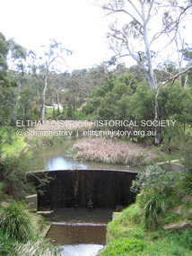 Eltham District Historical Society Inc
Photograph - Digital Photograph, Marguerite Marshall, Smith Dam, Karingal Drive, Eltham, 19 September 2006
... engineer, D. B. (Bernie) Smith to water the 24 acre (9.75 ha) hobby farm owned by himself and new wife, Isa Smith. Upon completion of the dam a pump-house was constructed beside the creek but before the water could be pumped up the hill they had to dig a trench and lay 500m of 100mm water main to an elevated holding tank. The Smiths made the pump-house their home for several years until they constructed their home at the top of the hill overlooking Eltham and views...engineer, D. B. (Bernie) Smith to water the 24 acre (9.75 ha) hobby farm owned by himself and new wife, Isa Smith. Upon completion of the dam a pump-house was constructed beside the creek but before the water could be pumped up the hill they had to dig a trench and lay 500m of 100mm water main to an elevated holding tank. The Smiths made the pump-house their home for several years until they constructed their home at the top of the hill overlooking Eltham and views ...The dam at the entrance to the Nerreman Gateway in Eltham was built according to an internationally acclaimed theory developed by the builder's father. In 1920, Victorian engineer B.A. Smith was awarded the American Society of Civil Engineers J. James R. Cross Gold Medal for his Technical Paper titled 'Arched Dams'. It was the first time this medal had been awarded outside the United States. The concrete arched dam across the Eltham West Drain was built in 1940 by B.A. Smith's son and engineer, D. B. (Bernie) Smith to water the 24 acre (9.75 ha) hobby farm owned by himself and new wife, Isa Smith. Upon completion of the dam a pump-house was constructed beside the creek but before the water could be pumped up the hill they had to dig a trench and lay 500m of 100mm water main to an elevated holding tank. The Smiths made the pump-house their home for several years until they constructed their home at the top of the hill overlooking Eltham and views extending to Kinglake. Following Bernie's death in 1983, Nerreman Park was subdivided between 1993 and 1995. Gordon Ford designed the landscaping and the pump-house was demolished. Covered under Heritage Overlay, Nillumbik Planning Scheme. Published: Nillumbik Now and Then / Marguerite Marshall 2008; photographs Alan King with Marguerite Marshall.; p137 The dam at the entrance to the Nerreman Gateway in Eltham, was built according to an internationally acclaimed theory developed by the builder’s father. In 1920, Victorian engineer B A Smith was awarded the American Society of Civil Engineers J. James R. Croes Gold Medal, for his Technical Paper titled Arched Dams. It was the first time this medal had been awarded outside America. An international example of the application of Smith’s work can be found in the design of the Hoover Dam on the Colorado River, Nevada, USA. Built between 1930 and 1936, it is recognised by the ASCE as one of ‘America’s Seven Modern Civil Engineering Wonders’.1 The concrete arched dam across the Eltham West Drain was built by B A Smith’s son and engineer, D B (Bernie) Smith. Bernie’s dam followed his father’s theory, having a curvature that takes maximum advantage of concrete’s great strength in compression. The water load is carried into the abutments because of this curvature, which permits a wall thickness of only 225 millimetres thick at its crest, despite the dam’s capacity of more than 4.5 megalitres. The Eltham dam was designed to water the 24 acre (9.75 ha) hobby farm belonging to newly married couple Bernie and Isa Smith. Bernie, from Armadale, and Isa, from a farm at Tyntynder near Swan Hill, were attracted to the hilly topography and the creek running through the property. It extended from Ryans Road, Eltham, to Karingal Drive, Montmorency and was adjacent to Meruka Park. The Smiths named it Nerreman Park using the Aboriginal word Nerreman meaning ‘River Bend’ as their creek had a pronounced bend.2 In 1940 the first thing Bernie did was to build a dam, and with Isa’s help, a pump-house, to secure a water supply for their cattle, pigs, chickens, orchard and vegetable gardens. It was also available for the fire-plugs, which they placed all over the property in case of bushfire. The couple built the pump-house beside the creek and installed a Tange three-plunger pump, which had originally supplied the City of Wodonga with water. But before the Smiths could pump water up the hill from the dam they had to dig a trench and lay about 550 yards (500m) of a four-inch (100mm) water main up to an elevated holding tank. The trench was dug with a single furrow plough drawn by an old draught horse. Living in rough conditions did not deter the Smiths, who made the pump-house their home, where they still lived when their first child was born in 1944. They later built their home at the top of their property overlooking Eltham, with magnificent views to Kinglake, the Dandenong Ranges and Melbourne. From 1946 it took them almost 20 years to complete the 36-square house with its 12-foot (3.6m) high ceilings. Material for the concrete roof and walls faced with sandstone, was ripped out of the ground on their property by plough pulled by tandem Clydesdale horses. Isa was a strong woman – two days before their second child was born – she set three huge sandstone boulders in place in the bottom wall of the garage. She also mixed all the cement for the house. A collapsed kitchen wall did not discourage her from rebuilding it in a week, while her husband was away working in the country. She later recalled: ‘We stood back to admire this beautiful wall we’d built and while we were looking at it, it came tumbling down’.3 Following Bernie’s death in 1983, Nerreman Park was subdivided, between 1993 and 1995. Local Gordon Ford designed the landscaping and the pump-house was pulled down. But the dam remains as a reminder of exceptional engineering4 – and of a remarkable couple.This collection of almost 130 photos about places and people within the Shire of Nillumbik, an urban and rural municipality in Melbourne's north, contributes to an understanding of the history of the Shire. Published in 2008 immediately prior to the Black Saturday bushfires of February 7, 2009, it documents sites that were impacted, and in some cases destroyed by the fires. It includes photographs taken especially for the publication, creating a unique time capsule representing the Shire in the early 21st century. It remains the most recent comprehenesive publication devoted to the Shire's history connecting local residents to the past. nillumbik now and then (marshall-king) collection, eltham, karingal drive, smiths dam, bernie smith, gordon ford, isa smith, nerreman gateway, nerreman park estate, dams -
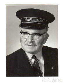 Bendigo Historical Society Inc.
Photograph - BASIL MILLER COLLECTION: PORTRAIT OF BASIL MILLER
... Engineers in World War II. In the 1920's Basil obtained employment with the Electric Supply Company of Victoria as an 'oiler boy' and later Junior Conductor. He rose through Conductor, Motorman and Inspector to retire as Senior Inspector when the State Electricity Commission of Victoria closed the Bendigo Tramways in April 1972. He was involved in Tramway Union affaird for many years and his staunch views...Engineers in World War II. In the 1920's Basil obtained employment with the Electric Supply Company of Victoria as an 'oiler boy' and later Junior Conductor. He rose through Conductor, Motorman and Inspector to retire as Senior Inspector when the State Electricity Commission of Victoria closed the Bendigo Tramways in April 1972. He was involved in Tramway Union affaird for many years and his staunch views ...Basil William Bates Miller was born in Castlemaine on 27th June, 1908, the eldest child of Ferdinand and Lavina. The family moved to Bendigo and subsequently to a house in King Street, where Basil lived for over 70 years. All the family were musical and Basil became accomplished at Piano, organ and violin. He was honorary organist at his church and many Masonic Lodges for up to 40 years. He served in the Bendigo Regiment and as a warrant Officer in the Royal Australian Engineers in World War II. In the 1920's Basil obtained employment with the Electric Supply Company of Victoria as an 'oiler boy' and later Junior Conductor. He rose through Conductor, Motorman and Inspector to retire as Senior Inspector when the State Electricity Commission of Victoria closed the Bendigo Tramways in April 1972. He was involved in Tramway Union affaird for many years and his staunch views on inductrial matters were well known. He remained active during almost 30 years of retirement and died in the Bendigo Hospitral on 14th August, 2001 at the age of 93. Black and white photograph of Basil Miller, Senior Traffic Inspector of Bendigo Tramways, in uniform, looking to the right. Martin Washington written in pencil, bottom right corner. Mounted on cream card. Basil left his tramways collection of photographs and documents to the Bendigo Historical Society. Mr. Arthur Penna, 78 emmett Street, Golden Square, was the executor of Basil's will.person, individual, basil miller -
 The Beechworth Burke Museum
Photograph, c1900
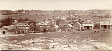
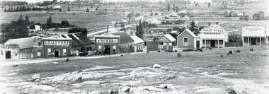
... view across to residences and open land. Businesses included, Joseph E. Bishop, Coach Builders; Straughair Duncan, Engineers, Blacksmiths & Farriers; Straughair Duncan, Beechworth Foundry; Wholesale & Retail Est. 1855, Mackenzie Family Store ; and T. ...view across to residences and open land. Businesses included, Joseph E. Bishop, Coach Builders; Straughair Duncan, Engineers, Blacksmiths & Farriers; Straughair Duncan, Beechworth Foundry; Wholesale & Retail Est. 1855, Mackenzie Family Store ; and T. ...Taken around 1858, depicting a row of five business buildings on a rocky, sloping hillside at New Town, with a view across to residences and open land. Businesses included, Joseph E. Bishop, Coach Builders; Straughair Duncan, Engineers, Blacksmiths & Farriers; Straughair Duncan, Beechworth Foundry; Wholesale & Retail Est. 1855, Mackenzie Family Store ; and T. Pratten, Grocer. The Mental Hospital can be seen in the background. Mark Straughair and John Duncan, established the Beechworth Foundry, Newtown in 1858 and went on to build an important industry, employing around sixteen men, after acquiring Alexander Roger's New Ford Street Foundry in the late 1860s. Making and repairing mostly mining and agricultural machinery for the Ovens District and a Beechworth brewery, the business continued to function after Straughair's death in 1882, up until the death of Duncan in 1896, when the business folded. This photograph is historically significant because it shows the development of the businesses in Beechworth from the early establishment of the town.Sepia rectangular photograph printed on photographic paper mounted on boardObverse: [Pin holes from circular tacks in all four corners] Reverse: 84.216-1/ Newtown/ 1997.2650/ 21/ BMM3056/new town, newtown, newtown beechworth, local business, 1858, 1850s beechworth, joseph e. bishop, coach builder, coach, mark straughair, m. straughair, straughair and duncan, john duncan, j. duncan, beechworth foundry, mackenzie family store, t. pratten, grocer, beechworth grocers, beechworth mental asylum, beechworth mental hospital, mayday hills mental asylum, mental hospital, alexander rogers, new ford street foundry, 1860s beechworth, 1860s, mining machinery, agricultural machinery, manufacturing, bridge road -
 The Beechworth Burke Museum
Photograph, Circa 1858
... view across to residences and open land. Businesses included, Joseph E. Bishop, Coach Builders; Straughair Duncan, Engineers, Blacksmiths & Farriers; Straughair Duncan, Beechworth Foundry; Wholesale & Retail Est. 1855, Mackenzie Family Store ; and T. ...view across to residences and open land. Businesses included, Joseph E. Bishop, Coach Builders; Straughair Duncan, Engineers, Blacksmiths & Farriers; Straughair Duncan, Beechworth Foundry; Wholesale & Retail Est. 1855, Mackenzie Family Store ; and T. ...Taken around 1858, depicting a row of five business buildings on a rocky, sloping hillside at New Town, with a view across to residences and open land. Businesses included, Joseph E. Bishop, Coach Builders; Straughair Duncan, Engineers, Blacksmiths & Farriers; Straughair Duncan, Beechworth Foundry; Wholesale & Retail Est. 1855, Mackenzie Family Store ; and T. Pratten, Grocer. Eleven men may be seen outside the Foundry building. The Mental Hospital can be seen in the background. Mark Straughair and John Duncan, established the Beechworth Foundry, Newtown in 1858 and went on to build an important industry, employing around sixteen men, after acquiring Alexander Roger's New Ford Street Foundry in the late 1860s. Making and repairing mostly mining and agricultural machinery for the Ovens District and a Beechworth brewery, the business continued to function after Straughair's death in 1882, up until the death of Duncan in 1896, when the business folded. This photograph is historically significant because it shows the development of the businesses in Beechworth from the early establishment of the town.Black and white rectangular photograph printed on photographic paperReverse: [Agfa wordmarks: diamond-shaped watermarks for Agfa photographic paper] 1997.2642/ refer to/ 1997 2650/ 3056joseph e. bishop, mark straughair, john duncan, mackenzie family store, beechworth foundry, coach, coach builder, engineer, blacksmith, farrier, t. pratten, beechworth grocers, grocer, new town, newtown beechworth, newtown, foundry, 1858, local business, new ford street foundry, alexander rogers, victorian agricultural history, mining machinery, beechworth brewery, ovens district, mayday hills mental asylum, beechworth mental hospital, beechworth mental asylum, mental hospital, mental -
 The Beechworth Burke Museum
Photograph, 1960s
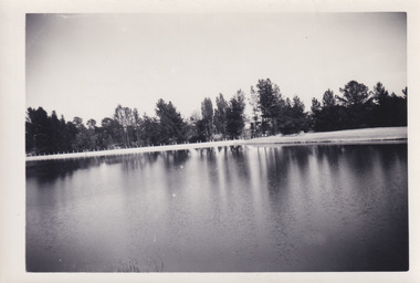
... view across the lake from the east side, the photo was taken during a period of improvements to the lake and surrounding area. Lake Sambell is an artificial lake that was created on the site of the old Rocky Mountain Mining Company workings and was officially opened by Minister for Lands, Mr Baily, on October 5, 1928. The disused and unattractive remains of the mine were converted into a recreational area intended for swimming, boating, and fishing. The lake is named after Mr L.H. Sambell, shire engineer...view across the lake from the east side, the photo was taken during a period of improvements to the lake and surrounding area. Lake Sambell is an artificial lake that was created on the site of the old Rocky Mountain Mining Company workings and was officially opened by Minister for Lands, Mr Baily, on October 5, 1928. The disused and unattractive remains of the mine were converted into a recreational area intended for swimming, boating, and fishing. The lake is named after Mr L.H. Sambell, shire engineer ...This photograph was taken in the 1960s at Lake Sambell and is a view across the lake from the east side, the photo was taken during a period of improvements to the lake and surrounding area. Lake Sambell is an artificial lake that was created on the site of the old Rocky Mountain Mining Company workings and was officially opened by Minister for Lands, Mr Baily, on October 5, 1928. The disused and unattractive remains of the mine were converted into a recreational area intended for swimming, boating, and fishing. The lake is named after Mr L.H. Sambell, shire engineer and secretary of the Forward Beechworth Committee, who advocated for the enhancement of Beechworth into a tourist destination and was central to the planning and establishment of the lake. Funding for the project was raised through both competition funds and donations. Since the construction in 1928 several engineering issues have arisen. In 1939 the water levels were low, and the lake was considered both an eyesore and ‘mudhole’, Beechworth Shire Council sort funding to raise the height of the lake six feet to improve the quality of water. Throughout the 1940s the Beechworth Swimming Club sort to address the structural engineering issues and improve swimming facilities at the lake. R.E. Carter, similar to L.H. Sambell, was a shire engineer who advocated the importance of positioning Beechworth as a tourist destination. Carter held the position of shire engineer from 1954-63 and organised many improvements to the Lake Sambell area including the caravan park in 1959, the lake swimming pool in 1961, water skiing and boating facilities, and increased the lake surface area in 1964. These improvements to the lake also reflect an increase in leisure time and access to travel during a period of post-war prosperity in Australia during the 1950s and 60s. This photograph is of historical significance as it documents Lake Sambell in the 1960s after a series of enhancements to the lake area to improve its appearance and usability for both the people of Beechworth and tourists. It is also of social significance in providing an insight into the increase in leisure time and access to travel during a period of post-war prosperity. Black and white rectangle photograph printed on photographic paper and unmounted.Reverse: 3534 C798lake sambell, l.h. sambell, r.e. carter, rocky mountain mining company, forward beechworth committee, beechworth swimming club, wallace park lake sambell development scheme, lake sambell caravan park, beechworth 1960s, lake sambell swimming pool, lake sambell boating, lake sambell fishing, swimming, boating, water skiing, fishing, post-war prosperity, minister of lands, artificial lake, open cut sluice mine, lake -
 Montmorency–Eltham RSL Sub Branch
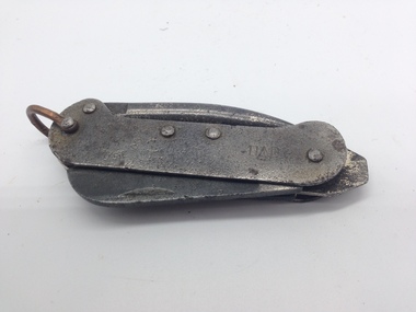
Knife, Clasp, with Marlin Spike and Tin Opener - Carr Fast second pattern, World War Two era
... Montmorency–Eltham RSL Sub Branch Petrie Park 16 Mountain View Road Montmorency melbourne Two patterns of clasp knife were supplied to the Australian Military Forces in the WW2 era by the Carr Fastener Company. These clasp knives were identical to those made by Whittingslowe Engineers that were made in the Whittingslowe factory under contract to Carr Fasteners. ...Two patterns of clasp knife were supplied to the Australian Military Forces in the WW2 era by the Carr Fastener Company. These clasp knives were identical to those made by Whittingslowe Engineers that were made in the Whittingslowe factory under contract to Carr Fasteners. William Whittingslowe had a close association with Carr Fasteners prior to WW2 and had been Chairman of Carr Fasteners for some time.Smaller sized canoe shaped body military steel clasp knife. The clasp knife is the Carr Fast second pattern with the improved tin opener, manufactured in Australia in the World War Two era. The clasp knife has a blade, a tin/bottle opener, a marline spike as well as a screw driver and a copper wire shackle used to attach the knife to a lanyard or belt clip. The body of the knife is held together by steel rivets. Indentations to aid opening are located on the top RHS of the blade, and on the top LHS of the tin opener. The end of the tin opener is shaped to a point.CARR FAST CO AUST D (broad arrow pattern) Dclasp knife, world war two, australian military forces, steel -
 Mission to Seafarers Victoria
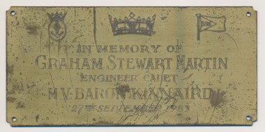
Plaque - Memorial plaque, Graham Stewart Martin, 1983
... view the plaque. The Mission is a place of memorial for seafarers. graham stewart martin engineer cadet m.v. baron kinnaird scottish ship management ssm 1983 america's cup bench Engraved: In Memory of / Graham Stewart Martin / Engineer Cadet / MV Baron Kinnaird / 27th September 1983 Rectangular brass plaque, on top 3 logos: Merchant Navy, Merchant Navy crown and flag of the SSM (Scottish Ship Management) Graham Stewart Martin Plaque Memorial plaque ...Graham was born in 1962 in Glasgow, Scotland. He grew up in the south side of Glasgow and became an active member of the Boys Brigade, progressing through the different sections to eventually gain the organisation's highest award, the Queens Badge. During these years Graham became a proficient bugler and trumpeter, taking part in many nationwide competitions as part of the company band. After completion of his school education, Graham was accepted as an apprentice engineering officer by the Scottish Ship Management who ran a fleet of bulk carriers. After training at the Glasgow Nautical College he then went to sea, firstly on the MV Baron Napier and subsequently the MV Baron Kinnaird, the ship he was on when he travelled to Australia. On the 27th November 1983, there were parties throughout Australia to celebrate the winning of The Americas Cup yacht race, Melbourne was no exception and Graham and several colleagues went ashore to join in. During the celebrations, Graham climbed up some scaffolding to get a better view but a girder became disloged and he fell to the ground and was struck by the falling girder. He died shortly after despite the best efforts of the ambulance crews. Graham's body was returned home to Glasgow and a cremation service took place in the Linn Crematorium near where he lived and grew up. Money was donated by the ship's crew and officer and sent to the Mission (Reverend Chin) to purchase an engraved plaque in his memory. The plaque was mounted on a bench used as coffee table. In January 2025, Alain, his former girlfriend visited the Mission to view the plaque.The Mission is a place of memorial for seafarers.Rectangular brass plaque, on top 3 logos: Merchant Navy, Merchant Navy crown and flag of the SSM (Scottish Ship Management)Engraved: In Memory of / Graham Stewart Martin / Engineer Cadet / MV Baron Kinnaird / 27th September 1983graham stewart martin, engineer cadet, m.v. baron kinnaird, scottish ship management, ssm, 1983, america's cup, bench -
 Mission to Seafarers Victoria
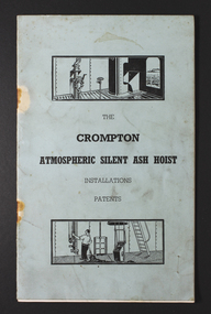
Manual, Crompton Atmospheric Silent Ash Hoist Installation Patents
... The memorabilia relates to his career at sea and in particular the role of an engineer, including a handwritten manual of notes and references relating to the mechanical and engineering aspects and areas of responsibility for maintenance. ship engines ship maintenance ash hoists coal clinker george winfield duncan (1922-2017) ship engineer s.s. athenic see attached image Pale blue soft cover commercially printed manual or handbook relating to patents for Crompton Atmospheric Silent Ash Hoists. Features small diagram of figure pulling on a chain and view ...Relates to management by engine room firemen of Ash and soot and clinker in the engine room of a steam ship. Hoists were used to discharge accumulated ash at the end of shifts. Mariner Duncan had a particular regard for the Mission to Seafarers. This plate for display on a commissioned new table at the MTSV chapel acknowledges his bequest and the material donated. Collectively the G W Duncan material includes: photographs, professional data memorabilia and written and commercially printed resources. The memorabilia relates to his career at sea and in particular the role of an engineer, including a handwritten manual of notes and references relating to the mechanical and engineering aspects and areas of responsibility for maintenance. Pale blue soft cover commercially printed manual or handbook relating to patents for Crompton Atmospheric Silent Ash Hoists. Features small diagram of figure pulling on a chain and view of ship silhouette on horizon seen through a porthole.see attached imageship engines, ship maintenance, ash hoists, coal, clinker, george winfield duncan (1922-2017), ship engineer, s.s. athenic -
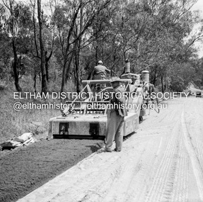
 Eltham District Historical Society Inc
Negative - Photograph, J.A. McDonald, Eltham, Susan Street, Jan. 1961
... view) Record of various Shire of Eltham infrastructure works undertaken during the period of 1952-1962 involving bridge and road reconstruction projects, sometimes with Eltham Shire Council Project Reference numbers quoted. It was during this period that a number of significant improvements were made to roads and new bridges constructed within the shire that remain in place as of present day (2022). In many situations, the photos provide a tangible visible record of infrastructure that existed throughout the early days of the Shire. The album was put together by or under the direction of the Shire Engineer ...January 1961 Looking towards Dalton Street (present-day Withers Way) Just south of Brougham Street. To the immediate left is the present-day car park for the Elham Leisure Centre. The house on the left is immediately opposite Cromwell street and adjacent to the southwest corner of the Leisure Centre buiding (where the Williams house sits hidden from view)Record of various Shire of Eltham infrastructure works undertaken during the period of 1952-1962 involving bridge and road reconstruction projects, sometimes with Eltham Shire Council Project Reference numbers quoted. It was during this period that a number of significant improvements were made to roads and new bridges constructed within the shire that remain in place as of present day (2022). In many situations, the photos provide a tangible visible record of infrastructure that existed throughout the early days of the Shire. The album was put together by or under the direction of the Shire Engineer, J.A. McDonald.shire of eltham, infrastructure, 1961-01, cromwell street, eltham leisure centre, road construction, susan street -
 Eltham District Historical Society Inc
Negative - Photograph, J.A. McDonald, Eltham, Susan Street, Jan. 1961
... view) Record of various Shire of Eltham infrastructure works undertaken during the period of 1952-1962 involving bridge and road reconstruction projects, sometimes with Eltham Shire Council Project Reference numbers quoted. It was during this period that a number of significant improvements were made to roads and new bridges constructed within the shire that remain in place as of present day (2022). In many situations, the photos provide a tangible visible record of infrastructure that existed throughout the early days of the Shire. The album was put together by or under the direction of the Shire Engineer ...January 1961 Looking south Brown excavating Brougham to Dalton (present-day Withers Way) F. Woods Consolidating showing soft fill over culvert after 9 months Just south of Brougham Street. To the immediate left is the present-day car park for the Elham Leisure Centre. The house on the left is immediately opposite Cromwell street and adjacent to the southwest corner of the Leisure Centre buiding (where the Williams house sits hidden from view)Record of various Shire of Eltham infrastructure works undertaken during the period of 1952-1962 involving bridge and road reconstruction projects, sometimes with Eltham Shire Council Project Reference numbers quoted. It was during this period that a number of significant improvements were made to roads and new bridges constructed within the shire that remain in place as of present day (2022). In many situations, the photos provide a tangible visible record of infrastructure that existed throughout the early days of the Shire. The album was put together by or under the direction of the Shire Engineer, J.A. McDonald.shire of eltham, infrastructure, 1961-01, cromwell street, eltham leisure centre, road construction, susan street -
 Eltham District Historical Society Inc
Album - Photograph, J.A. McDonald, Dixons Creek Bridge, c. 1962
... View looking upstream ? east Record of various Shire of Eltham infrastructure works undertaken during the period of 1952-1962 involving bridge and road reconstruction projects, sometimes with Eltham Shire Council Project Reference numbers quoted. It was during this period that a number of significant improvements were made to roads and new bridges constructed within the shire that remain in place as of present day (2022). In many situations, the photos provide a tangible visible record of infrastructure that existed throughout the early days of the Shire. The album was put together by or under the direction of the Shire Engineer ...Dixons Creel Bridge Broken head of pile View looking upstream ? eastRecord of various Shire of Eltham infrastructure works undertaken during the period of 1952-1962 involving bridge and road reconstruction projects, sometimes with Eltham Shire Council Project Reference numbers quoted. It was during this period that a number of significant improvements were made to roads and new bridges constructed within the shire that remain in place as of present day (2022). In many situations, the photos provide a tangible visible record of infrastructure that existed throughout the early days of the Shire. The album was put together by or under the direction of the Shire Engineer, J.A. McDonald.'66' written in pencil1962, bridge construction, dixons creek bridge, dixon's creek road, infrastructure, road construction, shire of eltham -
 Eltham District Historical Society Inc
Negative - Photograph, J.A. McDonald, Eltham, Mount Pleasant Road, c.May 1958
... view Record of various Shire of Eltham infrastructure works undertaken during the period of 1952-1962 involving bridge and road reconstruction projects, sometimes with Eltham Shire Council Project Reference numbers quoted. It was during this period that a number of significant improvements were made to roads and new bridges constructed within the shire that remain in place as of present day (2022). In many situations, the photos provide a tangible visible record of infrastructure that existed throughout the early days of the Shire. The album was put together by or under the direction of the Shire Engineer ...Stabilising just below Metery Road below Metery Road No. 18 just visible at left of viewRecord of various Shire of Eltham infrastructure works undertaken during the period of 1952-1962 involving bridge and road reconstruction projects, sometimes with Eltham Shire Council Project Reference numbers quoted. It was during this period that a number of significant improvements were made to roads and new bridges constructed within the shire that remain in place as of present day (2022). In many situations, the photos provide a tangible visible record of infrastructure that existed throughout the early days of the Shire. The album was put together by or under the direction of the Shire Engineer, J.A. McDonald.infrastructure, shire of eltham, 1958-05, footpaths and gutters, mount pleasant road, road construction -
 Eltham District Historical Society Inc
Negative - Photograph, George W. Bell, Wingrove Cottage, Main Road, Eltham, Vic, c.1955
... View looking across Main Road to Wingrove Cottage (c.1950s), former home Charles Symons Wingrove. Charles Wingrove was a prominent figure in Victorian local government, as secretary to the Eltham District Road Board and Shire Council from 1858 to 1904, and, as Shire Engineer and Secretary to the Heidelberg Road Board. ...View looking across Main Road to Wingrove Cottage (c.1950s), former home Charles Symons Wingrove. Charles Wingrove was a prominent figure in Victorian local government, as secretary to the Eltham District Road Board and Shire Council from 1858 to 1904, and, as Shire Engineer and Secretary to the Heidelberg Road Board. ...View looking across Main Road to Wingrove Cottage (c.1950s), former home Charles Symons Wingrove. Charles Wingrove was a prominent figure in Victorian local government, as secretary to the Eltham District Road Board and Shire Council from 1858 to 1904, and, as Shire Engineer and Secretary to the Heidelberg Road Board. He was part of the Committee to establish the Church of England at Eltham. The Wingroves were an important pioneer family of Eltham and Wingrove Cottage is one of the most important heritage buildings in Eltham as one of the few surviving 19th century buildings. Reputedly built in 1858, Wingrove Cottage was recorded in the 1859-60 Eltham Road District rates book as a brick house owned and occupied by Wingrove with a Net Annual Value (NAV) of ₤30. In 1861, the year the Church opened, Wingrove's house was identified as a two -roomed brick cottage. Charles Wingrove is buried with other members of his family in the cemetery at St Katherine’s Church, St. Helena. This image is believed to have been incorporated in a presentation by Russell Yeoman to the 10 November 2004 Society meeting on "Significant Trees, Wildflowers and Local Gardens."This photo forms part of a collection of photographs gathered by the Shire of Eltham for their centenary project book,"Pioneers and Painters: 100 years of the Shire of Eltham" by Alan Marshall (1971). The collection of over 500 images is held in partnership between Eltham District Historical Society and Yarra Plenty Regional Library (Eltham Library) and is now formally known as the 'The Shire of Eltham Pioneers Photograph Collection.' It is significant in being the first community sourced collection representing the places and people of the Shire's first one hundred years.Digital image 4 x 5 inch B&W Negshire of eltham pioneers photograph collection, eltham, main road, wingrove cottage, george w. bell collection, significant tree -
 Eltham District Historical Society Inc
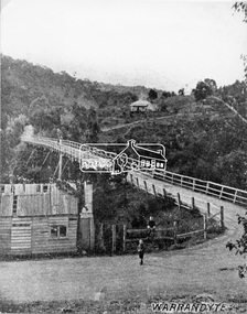
Negative - Photograph, Warrandyte Bridge over River Yarra, c.1910
... View of the 1875 timber trestle bridge over the Yarra River reproduced from a newsprint image. Also known as Anderson's Creek (Road) Bridge A contract was accepted for William Elliot to erect a bridge over the Yarra River at Warrandyte on Anderson's Creek Road and other improvements for £1,331.6.2 - Gazette No. 143. Tuesday, November 13th 1860 - http://gazette.slv.vic.gov.au/view.cgi?year=1860&class=general&page_num=2161&state=V&classNum=G143&id=). The bridge was washed away by floods in 1863. It was replaced with a taller timber trestle structure in October 1875, designed and built by C.S. Wingrove, Shire Clerk, Engineer...View of the 1875 timber trestle bridge over the Yarra River reproduced from a newsprint image. Also known as Anderson's Creek (Road) Bridge A contract was accepted for William Elliot to erect a bridge over the Yarra River at Warrandyte on Anderson's Creek Road and other improvements for £1,331.6.2 - Gazette No. 143. Tuesday, November 13th 1860 - http://gazette.slv.vic.gov.au/view.cgi?year=1860&class=general&page_num=2161&state=V&classNum=G143&id=). The bridge was washed away by floods in 1863. It was replaced with a taller timber trestle structure in October 1875, designed and built by C.S. Wingrove, Shire Clerk, Engineer ...View of the 1875 timber trestle bridge over the Yarra River reproduced from a newsprint image. Also known as Anderson's Creek (Road) Bridge A contract was accepted for William Elliot to erect a bridge over the Yarra River at Warrandyte on Anderson's Creek Road and other improvements for £1,331.6.2 - Gazette No. 143. Tuesday, November 13th 1860 - http://gazette.slv.vic.gov.au/view.cgi?year=1860&class=general&page_num=2161&state=V&classNum=G143&id=). The bridge was washed away by floods in 1863. It was replaced with a taller timber trestle structure in October 1875, designed and built by C.S. Wingrove, Shire Clerk, Engineer and Surveyor for Eltham Shire Council. A replacement for this bridge was commenced in 1955 to cope with increasing traffic and this structure was widened in 2018 to meet further traffic demands. Argus (Melbourne, Vic. : 1848 - 1957), Thursday 23 September 1875, page 7 ________________________________________ THE WARRANDYTE BRIDGE. The ceremony of formally opening the newly erected bridge over the Yarra at Ander-son's Creek was performed on Monday last, in the presence of the members of the Eltham and Bulleen shire councils whose territories it joins, and a goodly number of the residents of the district. The task was delegated to Mr. Cameron, M.L.A., who, after a few introductory remarks declared the bridge to be opened, and christened it the " Warrandyte Bridge." The party then adjourned to Grant's Hotel, where a cold collation had been prepared. The chair was taken by the president of the Eltham shire (Mr. John Bell) and the vice chair by Mr. Kent, a member of the Bulleen council. Mr Robert Williamson proposed "Success to the bridge," coupling with it the name of Mr. Cameron, to whose exertions was in the main to be attributed the erection of that structure which was an ornament to the district and would prove of great service to both sides of the river. Mr. Cameron, in responding, alluded to the great difficulties, mainly of a pecuniary nature, that had been encountered in carrying out the project, and which had only been got over by their united efforts and by the liberal spirit in which the late Commissioner of Roads had dealt with the case. The healths of the contractor and the engineer were also drunk. The bridge is a trussed timber one, resting on yellow box piles sunk into the solid rock, each pier being weighted with 50 tons of stone. The abutments consist of dry stone walls, 6ft. thick at the base, and tapering to 3ft. on the top, the face of the work having a batter of 1 to 1. The length of the bridge is 308ft., there being four openings in the centre of 66ft. each, and two at the ends of 20ft. each. The width in the clear is 9½ft., and the height from the bed of the river about 33ft. The approaches comprise 1,100 cubic yards of earthwork, and the formation of 48 chains of sideling, the whole cost of the work, which was carried out under the direction of the engineer to the Eltham Shire Council, being £1,413.This photo forms part of a collection of photographs gathered by the Shire of Eltham for their centenary project book,"Pioneers and Painters: 100 years of the Shire of Eltham" by Alan Marshall (1971). The collection of over 500 images is held in partnership between Eltham District Historical Society and Yarra Plenty Regional Library (Eltham Library) and is now formally known as the 'The Shire of Eltham Pioneers Photograph Collection.' It is significant in being the first community sourced collection representing the places and people of the Shire's first one hundred years.Digital image 4 x 5 inch B&W Neg B&W Print 12.5 x 9 cmsepp, shire of eltham pioneers photograph collection, warrandyte, bridge -
 Eltham District Historical Society Inc
Photograph, N. J. Tillings Timber Factory, 15 June, 1975, 15/06/1975
... Engineer, Mr. McDonald. [These photographs were part of their campaign to the Shire of Eltham in 1975] claiming that the zoning regulations were being breached by the occupants of various factories in the nearby light industrial zone [Brougham Street, Eltham] - to the detriment of those living in adjoining residential zones, and that, despite .. earlier objections and complaints, nothing was done about it." industrial estate brougham street eltham 1975 bolton street dick crichton n.j. tillings timber factory shire of eltham Inscribed on back: "View from residential premises in Brougham Street. ...Piles of dirt alongside dirt road, part of the light industrial area including N. J. Tillings Timber Factory, Brougham Street, Eltham. This is one of 7 B/W 8x10 inch photos with notes on obverse by Dick Crichton. Accompanying letter from Florence Chrichton 2013 : "Originally sent to Shire of Eltham Engineer, Mr. McDonald. [These photographs were part of their campaign to the Shire of Eltham in 1975] claiming that the zoning regulations were being breached by the occupants of various factories in the nearby light industrial zone [Brougham Street, Eltham] - to the detriment of those living in adjoining residential zones, and that, despite .. earlier objections and complaints, nothing was done about it." 1 black and white photograph printed with white border on three sidesInscribed on back: "View from residential premises in Brougham Street. Trees in foreground will soon be lost due to making of the main drain by M.M.B.W.. Photograph shows topographical features of the valley and how sound travels upwards and outwards to residential zones surrounding." industrial estate, brougham street, eltham, 1975, bolton street, dick crichton, n.j. tillings, timber factory, shire of eltham -
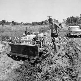
 Eltham District Historical Society Inc
Photograph, Russell Yeoman, Construction of fire access on Gumtree Road, Research, by Army Reserve Engineers under command of Captain Bill Oakley, c.1966, 1966c
... Bill Oakley was an engineer at the Shire of Eltham. Viewed from west looking east. ...Eltham District Historical Society Inc 728 Main Rd Eltham melbourne Bill Oakley was an engineer at the Shire of Eltham. Viewed from west looking east. ...Bill Oakley was an engineer at the Shire of Eltham. Viewed from west looking east. Road had more zigs and zags in those days on the west side. Russell Yeoman's FC Holden visible at bottom of hill. Digital file only; created from original colour positive slide transparencyresearch (vic.), russell yeoman collection, gumtree road, army reserve engineers, captain bill oakley, fc holden sedan, fire access, streets -
 Bendigo Historical Society Inc.
Newspaper - JENNY FOLEY COLLECTION: SNIPPETS OF BENDIGO HISTORY
... View Street story continued. In this article Edith Lunn describes Dudley House, originally the survey office and the oldest permanent government building in Bendigo. From 1854 surveyor Richard Larritt worked there. It was in 1890 that the name Dudley house was attached to the building. Town clerks W. Honeybone and H.C. Inleton lived there. Later it was the home of Dr. Peter Slater, after he moved out city engineer...View Street story continued. In this article Edith Lunn describes Dudley House, originally the survey office and the oldest permanent government building in Bendigo. From 1854 surveyor Richard Larritt worked there. It was in 1890 that the name Dudley house was attached to the building. Town clerks W. Honeybone and H.C. Inleton lived there. Later it was the home of Dr. Peter Slater, after he moved out city engineer ...BHS CollectionBendigo Weekly date unknown. '' Snippets of Bendigo history'' by Edith Lunn the View Street story continued. In this article Edith Lunn describes Dudley House, originally the survey office and the oldest permanent government building in Bendigo. From 1854 surveyor Richard Larritt worked there. It was in 1890 that the name Dudley house was attached to the building. Town clerks W. Honeybone and H.C. Inleton lived there. Later it was the home of Dr. Peter Slater, after he moved out city engineer Mr. Rex Anderson moved in. After his death the Bendigo branch of the Royal Historical Society of Victoria established its home there after 25 years Dudley House reverted to the Council. The clip is in a folder.newspaper, bendigo, bendigo weekly -
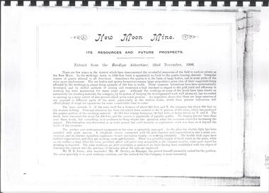 Bendigo Historical Society Inc.
Document - NEW MOON MINE RESOURCES AND FUTURE PROSPECTS REPORT
... Engineer, R.A. Dewar Battery Manager. Photo of directors: Joseph LanFranchi, W.B. Walker, Daniel Murdoch, John Green, Alexander Hay and Edward Bright. Photos include view...Engineer, R.A. Dewar Battery Manager. Photo of directors: Joseph LanFranchi, W.B. Walker, Daniel Murdoch, John Green, Alexander Hay and Edward Bright. Photos include view ...Copy of extract from the Bendigo Advertiser, 22nd November, 1906 spiral bound with plastic cover. On front: 'New Moon Mine Site, its resources and future prospects'. Document contains financial reports, gold extracted, shareholders, battery manager's report, map of leases held by New Moon Co and photos, see below. Photo of Managers of New Moon Co., H.E. Jones Mining Manager, J.C. McCoy Engineer, R.A. Dewar Battery Manager. Photo of directors: Joseph LanFranchi, W.B. Walker, Daniel Murdoch, John Green, Alexander Hay and Edward Bright. Photos include view from base of poppet legs showing tramway and crushing machine, battery and mine, miners at the 1045 level.bendigo, mining, new moon co. nl -
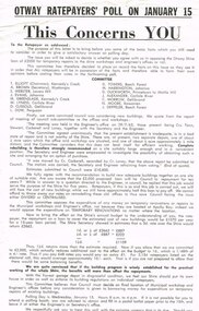 Otway Districts Historical Society
Poster, Colac Herald, Otway Ratepayers' Poll Flyer, 1963, 1963
... Engineer's office in the Apollo Bay Riding. This led to a number of objections at public meetings in the west and central ridings, such that a Committee of protest was formed, with a nominated Chairman, Secretary and members, to put to ratepayers their considered point-of-view of disapproval. ...Engineer's office in the Apollo Bay Riding. This led to a number of objections at public meetings in the west and central ridings, such that a Committee of protest was formed, with a nominated Chairman, Secretary and members, to put to ratepayers their considered point-of-view of disapproval. ...On 15 January 1964 the Shire of Otway was going to poll its ratepayers about a loan required to build temporary municipal workshops and a Shire Engineer's office in the Apollo Bay Riding. This led to a number of objections at public meetings in the west and central ridings, such that a Committee of protest was formed, with a nominated Chairman, Secretary and members, to put to ratepayers their considered point-of-view of disapproval. After drafts the Committee produced a printed flyer for distribution to ratepayers summarising the Committee's position. The Committee knew and agreed with a Council Sub-Committee's recommendation to Council of a new, adequate building on one site of suitable size. However, this did not happen. Instead Council moved for loans for temporary renovations of existing buildings. This the Committee objected to believing that Council must decide on a final location before any consideration is given to borrowing money for temporary repairs. This was the opinion the Committee put to ratepayers.B/W Flyer. Otway Ratepayers' Poll on January 15. This concerns YOU. To the Ratepayer as addressed. Details on Ballot Paper.ratepayers; shire of otway; -
 Port Melbourne Historical & Preservation Society
Photograph - Old wallpaper, Port Melbourne Council Chamber, David Thompson, 27 Jun 2006
... Engineer, Fred Cook. The Council Chamber was subsequently renovated in a simple style sympathetic to the Victorian period of the Town Hall's original construction. Fred COOK Port Melbourne Town Hall Art Deco Built Environment - Civic Digital copy of a colour photograph of a close-up view of old exposed wallpaper in the Council Chamber at Port Melbourne Town Hall after damage to the ceiling and walls. ...In June 2006, damage (from a leak in the roof?) to the ceiling and walls in the Council Chamber at Port Melbourne Town Hall exposed what looked like the Art Deco ceiling decoration and wallpaper from the 1938 renovation designed and installed by City Engineer, Fred Cook. The Council Chamber was subsequently renovated in a simple style sympathetic to the Victorian period of the Town Hall's original construction.Digital copy of a colour photograph of a close-up view of old exposed wallpaper in the Council Chamber at Port Melbourne Town Hall after damage to the ceiling and walls.fred cook, port melbourne town hall, art deco, built environment - civic