Showing 4475 items
matching the point
-
 Moorabbin Air Museum
Document (Item) - The Point 50 Inch Browning Machine Gun - Descriptive Notes
... The Point 50 Inch Browning Machine Gun - Descriptive Notes....The Point 50 Inch Browning Machine Gun - Descriptive Notes. ... -
Moorabbin Air Museum
Document (Item) - The Point 30 Inch Machine Gun L3A3 Or L3A4. Descriptive Notes
... The Point 30 Inch Machine Gun L3A3 Or L3A4. Descriptive...The Point 30 Inch Machine Gun L3A3 Or L3A4. Descriptive ... -
 Lara RSL Sub Branch
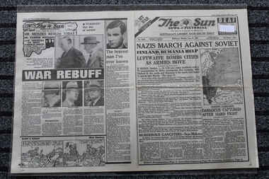
Newspaper - The Sun Newspaper Dated 23/6/1941 - Special - My War Part 18 - Nazis March Against Soviets, Local Newspaper Dated 23/6/1941 - special - My War Part 18 - Nazis March Against Soviets - The Turning Point
... - Nazis March Against Soviets - The Turning Point...nazis march against soviet - the turning point ...Local Newspaper reporting on World War 2 EventsHistorical record of World War 2 EventsLocal Newspaper Dated 23/6/1941 reporting World War 2 Events - Nazis March Against Soviets - The Turning PointNazis March Against Soviets - The Turning Point - My War Part 18nazis march against soviet - the turning point, world war 2, local newspaper dated 23/6/1941 -
 Warrnambool and District Historical Society Inc.
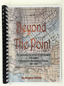
Booklet, Beyond the Point, 2007
... Beyond the Point ...This book was written in 2007 by Margaret McOrist to mark the 150th anniversary of the arrival in the Warrnambool area of John Logan. It is a sequel to a 1991 book, ‘Clotted Cream and Mangels’ which told the story of John Logan and his wife Mary Gardner. They lived at Hopkins Point, Warrnambool and the book, ‘Beyond the Point’ tells the story of the Logan descendants. When the farm land was sub-divided and sold the nearby beach was named ‘Logans Beach’. This book is of considerable interest as it tells the story of the descendants of important early settlers, John Logan and Mary Gardner. The area where they first settled is now of major interest as Logans Beach (named for the Logan family) is the well-known whale watching area. Southern Right Whales return to this beach each year and the females calve and remain up to three months at this beach, making it an important ‘whale nursery’. This is a soft cover book with black plastic ring binding and clear plastic sheets covering the front and back paper covers. The front cover has a reproduction of an 1891 map of Warrnambool and district with the title of the book and other information superimposed on the map. The back cover is black. The book has 101 pages and contains information on the Logan families who lived at Tooram in Allansford and their descendants. There are many black and white and colour photographs, diagrams, maps and family trees. Front Cover: ‘Beyond the Point, 150 years since the arrival of Irish ancestor, John Logan, Hopkins Point, Warrnambool, Victoria, 1857-2007, by Margaret McOrist’. john logan and mary gardner, hopkins point, logans beach, tooram, history of warrnambool -
 Marysville & District Historical Society
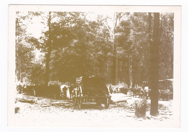
Postcard (item) - Black and white postcard, Marysville & District Historical Society Inc, Bullock Teams at the Dump, Woods Point Road, 1993
... Bullock Teams at the Dump, Woods Point Road. ...A black and white photograph of bullock teams at the Log Dump at on the Wood's Point Road.A black and white photograph of bullock teams at the Dump at on the Wood's Point Road. The Marysville-Woods Point Road was originally part of the Yarra Track, constructed in the early 1860s to provide access between Healesville and the Woods Point Goldfields. Despite the steep terrain and engineering difficulties, the Yarra Track soon became a busy route used by pack horses, horse-drawn drays, and wagons. Today this sealed mountain road is a popular scenic drive between Marysville and Warburton. This postcard was produced by the Marysville Historical Society as a souvenir of Marysville.YESTERYEAR POSTCARDS AFFIX/ STAMP/ HERE BULLOCK TEAMS AT THE DUMP,/ WOODS POINT ROAD. C Marysville Historical Society, 1993marysville, bullock teams, woods point road, victoria, marysville historical society, postcard, souvenir, yesteryear postcards, marysville-wood's point road, yarra track, healesville, mining, timber mills, warburton -
 City of Ballarat Libraries
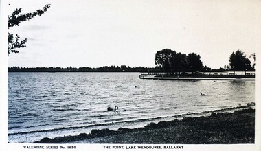
Postcard - Card Box Photographs, The Point, Lake Wendouree 1940c
... The Point, Lake Wendouree 1940c...The Point ...Valentine Series 1650the point, lake wendouree, public -
 Marysville & District Historical Society
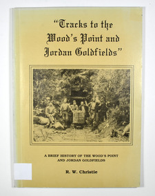
Book, Tracks to the Wood's Point and Jordan Goldfields-A brief history of the Wood's Point and Jordan Goldfields
... Tracks to the Wood's Point and Jordan Goldfields-A brief ...A history of the Wood's Point and Jordan gold fieldsPaperback. Beige cover. Front cover has a black and white photograph of miners standing and sitting around a mine cart that is sitting on railway tracks at the entrance to a mine.Back cover has a cartoon drawing of a pack horse that has fallen down a cliff with his rider trying to pull him back up by his tail. Inside the cover is a drawn map entitled 'Map of the Mining District round Wood's point'.Stamp of the Marysville & District Historical Society Inc / P.O. Box 22 / Marysville 3779 gold, gold field, gold mining, gold town, wood's point, jordan goldfields, victoria, australia, history, r w christie -
 Marysville & District Historical Society
Book, Tracks to the Wood's Point and Jordan Goldfields-A brief history of the Wood's Point and Jordan Goldfields
... Tracks to the Wood's Point and Jordan Goldfields-A brief ...A history of the Wood's Point and Jordan gold fieldsPaperback. Beige cover. Front cover has a black and white photograph of miners standing and sitting around a mine cart that is sitting on railway tracks at the entrance to a mine.Back cover has a cartoon drawing of a pack horse that has fallen down a cliff with his rider trying to pull him back up by his tail. Inside the cover is a drawn map entitled 'Map of the Mining District round Wood's point'.Stamp of Marysville & District / Historical Society Inc / P.O. Box 22 / Marysville 3779 gold, gold field, gold mining, gold town, wood's point, jordan goldfields, victoria, australia, history, r w christie -
 Federation University Historical Collection
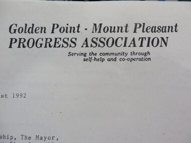
Document - Documents, Documents Relating to the Re-establishment of the Golden Point - Mt Pleasant Progress Association, 1983-1997, 1983-1997
... Documents Relating to the Re-establishment of the Golden ...Mara Gluyas was secretary of this organisation for 11 continuous years (1983-1994), and President Ian McKinnon was President for 9 years from 1983-1992). The inaugural 1983 committee was Ian McKinnon, Mara Gluyas, N. Strange, A. Graham, M. Davidson, M. Adams, Peter Hiscock, Ian Blomeley. The Association was concerned with the advancement of the Ballarat area in general and to promote Golden Point - Mt Pleasant area in particular. Small box with purple lid filled with the constitution, minutes associated with the Golden Point - Mt Pleasant Progress Association, and lists of members.mara glouyas, ian mckinnon, sovereign hill, pearce's park rotunda, elms, tree planting, sovereign hill lookout reserve, christmas carols, mine collapse, former golden point direction indicator, signage, norm strange, golden mount historical mines direction indicator, yarrowee creek tree planting committee, peady street, pearce street, barry davis, nerrina tip, ballarat observatory, carols by candlelight, yarrowee park project, magpie street bbq park, neighbourhood watch, magpie street park, cobden street, pryor street bus shelter, hill street, urban wildlife corridor, south street bluestone gutter, eastern baths site, grant street, street lighting, magpie street, letterhead, aboriginal advancement league, golden point primary school, sunnyside woollen mill, ballarat west goldfields, fred hunt, kerry daniell, craig ford, jack colin greville, jack colin greville plaque at mt pleasant lookout, golden point school oval -
Moorabbin Air Museum
Pamphlet (Item) - Procedure For The Sharpening Of Single Point Tools
... Procedure For The Sharpening Of Single Point Tools....Procedure For The Sharpening Of Single Point Tools. ... -
 Wodonga & District Historical Society Inc
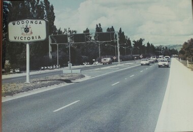
Photograph - Wodonga, Victoria sign and the Fruit Fly check point c1970s
... Wodonga, Victoria sign and the Fruit Fly check point c1970s...Wodonga, Victoria sign and the Fruit Fly check point c1970s ...The permanent fruit fly road blocks in Victoria began in 1958. The first was set up on the Lincoln Causeway between Albury and Wodonga. The aim was to protect the Victorian fruit export industry, the largest in the country. Cars would be stopped and inspected when entering Victoria. At peaks periods, such as Easter and school holidays, there were up to 10 inspectors at the 24 hour checkpoint near the former butter factory on the Lincoln Causeway. Local residents could apply for a pass which would be displayed on their window, but were still subject to random checks. Hundreds of tonnes of fruit each week was confiscated and pulverised by Department of Agriculture staff. The road block was closed in 1980, partly due to the increased traffic flows and the cost of maintaining inspection points.This image reflects government measures taken to protect the fruit industry in Victoria.A large image of the LIncoln Causeway at the Victorian/NSW border at Wodonga. The southbound lanes on the right hand side feature overhead signals and traffic light signs to control traffic leading into the Fruit fly inspection checkpoint ahead. The photo is in a wooden frame.On right hand side: Border sign: Wodonga/Victoria and the Victorian State Coat of Arms.fruit fly control, victoria border, lincoln causeway wodonga -
 Marysville & District Historical Society
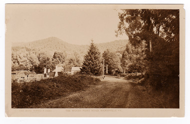
Postcard (item) - Black and white postcard, Rose Stereograph Company, The Wood's Point Road, Marysville, Vic, 1913-1967
... The Wood's Point Road, Marysville, Vic. ...A postcard in a series produced by the Rose Stereograph Company in Victoria, Australia as a souvenir of Marysville.A black and white photograph of the Wood's Point Road in Marysville , Victoria. This is now known as the Marysville-Wood's Point Road. The Marysville-Woods Point Road was originally part of the Yarra Track, constructed in the early 1860s to provide access between Healesville and the Woods Point Goldfields. Despite the steep terrain and engineering difficulties, the Yarra Track soon became a busy route used by pack horses, horse-drawn drays, and wagons. Today this sealed mountain road is a popular scenic drive between Marysville and Warburton.POST CARD REAL PHOTO THE "ROSE" SERIES DE LUXE PRODUCED IN AUSTRALIA Published by "The Rose Stereographer"/ Sydney and Melbourne.wood's point road, marysville-wood's point road, marysville, victoria, p. 10201, rose series postcard, postcard, souvenir, yarra track, mining, wood's point, warburton -
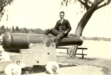 Federation University Historical Collection
Photograph, Vernon Holt, Frank Wright on the Canon at View Point, Lake Wendouree, 3/2/1922
... Frank Wright on the Canon at View Point, Lake Wendouree ...Frank Wright was a renown resident of Smeaton, where he was born. He lived at Laura Villa, and attended Smeaton State School. His father William was a gold miner and his mother's name was Sarah. Their family won many singing and instrumental awards. Frank was tutored by Percy Code and was awarded a gold medal for the highest marks in the ALCM examinations in the British Colonies at the age of seventeen years. He became the Australian Open Cornet Champion by the age of eighteen. A year later, Frank conducted the City of Ballarat Band, and later the Ballarat Soldiers’ Memorial Band. He formed the Frank Wright Frisco Band and Frank Wright and his Coliseum Orchestra. These bands won many South Street awards, and Frank as conductor won many awards in the Australian Band Championship contest. In 1933 Frank Wright sailed to England to conduct the famous St Hilda’s Band and was later appointed Musical Director of the London County Council, where he organized many amazing concerts in parks, in and around the London district. He was made Professor of Brass and Military Band Scoring and conducted at the Guildhall of Music and Drama. Frank was often invited to adjudicate Brass Band Championships around Europe, in Australia, including South Street and in New Zealand. The Frank Wright Medal at the Royal South Street competition is awarded to an individual recognized as making an outstanding contribution to brass music in Australia.Black and white photograph of a man dressed in a three piece suit sitting on a canon which is located in a park overlooking a lake. Trees and houses can be seen on the other side of the lake. The man is Frank Wright and the place is "View Point", Lake Wendouree, Ballarat.Written in pen on back - Frank Wright - on canon at "View Point", Lake Wendouree, Ballarat. Photo by Vernon Holt 3/2/22frank wright, vernon holt, lake wendouree, ballarat, canon -
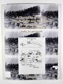 Marysville & District Historical Society
Book, A Chronicle of Life in Woods Point and Surrounds As seen Through "The Mountaineer" 1985 to present-Volume 1, 1989
A history of Woods Point and its surrounds as seen through 'The Mountaineer', a local paper published in Woods PointPaperback. Front cover has 3 of the same black and white photograph of old Woods Point. There is also a photograph of a Christmas themed front cover of The Mountaineer from December 1991. Back cover has 2 of the same photograph. Photograph is of a family standing next to a car that is parked outside the Wood's Point Hotel. In the background can be seen a shop on the left hand side of the road.Stamp of Marysville & District / Historical Society Inc / P.O. Box 22 / Marysville 3779woods point, the mountaineer, north east victoria, australia, history -
University of Melbourne, Burnley Campus Archives
Photograph - Sepia print, 13, 1929
Frank's Point"Frank's Point 1929."frank's point, 1929 -
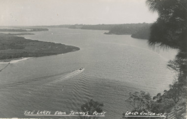 Lakes Entrance Historical Society
Postcard - Gippsland Lakes, H D Bulmer, Gippsland Lakes from Jemmy's Point, 1927 c
from Jemmys Point looking West showing boat on lake Rigby Fraser and Flannagan Islands to South steep wooded shoreline to North Lakes Entrance VictoriaBlack and white postcard taken from Jemmys Point looking West showing boat on lake Rigby Fraser and Flannagan Islands to South steep wooded shoreline to North Lakes Entrance VictoriaThe Lakes from Jemmys Point Lakes Entrance waterways, boating, islands -
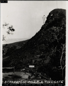 Lorne Historical Society
Photograph, Stradbroke Point and Tollgate on G.O.R
G.O.R. Passing Point and TollgateHarrisons Passing Pointtollgate g.o.r -
 Marysville & District Historical Society
Photograph (item) - Black and white photograph, Unknown
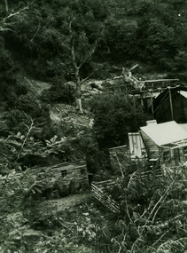
A black and white photograph of a gold mine, purported to be between Wood's Point and Jamieson.A black and white photograph of a gold mine, purported to be between Wood's Point and Jamieson.One of the mines (I think we passed this between/ Wood's Point and Jamieson)/ (photo given by Ken Morrison?)gold mine, wood's point, jamieson, gold sluice, photograph -
 Warrnambool and District Historical Society Inc.
Household, Souvenir Plate, 1920s
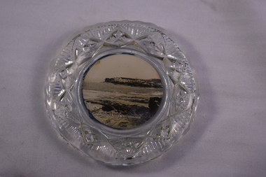
This souvenir plate was sold to tourists in Warrnambool in the 20th century. It features an image of a popular tourist spot off the coast of Warrnambool – Thunder Point. Tourism has always been an important industry in Warrnambool and souvenir items such as this one continue to be sold, although colour images would most likely be used now. This plate is of interest as an example of items sold to local tourists in the 20th century. It will be useful for display. This is a circular glass plate with a ripple pattern on the rim and an outer edge with the glass heavily-impressed and patterned. The base of the plate has a sepia-coloured image of Thunder Point, Warrnambool. The image has been taken from a photograph. This has been affixed to the back of the plate and has a dark blue backing. ‘Thunder Point Warrnambool’ tourism in warrnambool -
 Bendigo Military Museum
Book - ATLAS, PACIFIC, WW2, Brigadier General Vincent J. Esposito, THE WEST POINT ATLAS OF WAR/ WORLD WAR II: THE PACIFIC, Original 1959
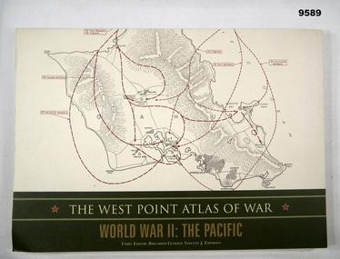
... THE WEST POINT ATLAS OF WAR/ WORLD WAR II: THE PACIFIC. ..."Originally published in 1959 as part of a two volume set. The West Point Atlas of War: World War II/ The Pacific provides a unique way of studying military history."Soft cover book. Cover - cardboard, beige and gold colour print on front, spine and back. Illustrated - front and back - red and black colour print of maps. 128 pages - cut, plain, off white colour, heavy gauge paper. Illustrated black, red and dark green maps and black and white photographs.publication, book, atlas, pacific, ww2 -
Phillip Island and District Historical Society Inc.
Newspaper clippings, 1888
Griffith Point had earlier been so named after Mr Griffiths, a fisherman.The Argus, July 9, 1888. At a public meeting, the inhabitants of Griffiths Point decided unanimously on the suggestion of Mr Fraser that the name of the newly proclaimed township should be named San Remo.local history, documents, newspapers, griffiths point, black & white newspaper clipping, griffiths point, the argus july 9 1988 -
 National Wool Museum
Photograph
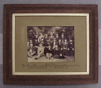
Photo depicts the Committee who organised the First Annual Picnic of the Employes of the Wool brokers Association Stores held at Schnapper Point, 23 March 1896Committee - First Annual Picnic of the Employes of the Wool brokers Association Stores held at Schnapper Point, 23 March 1896Committee - First Annual Picnic of the Employes of the Wool brokers Association Stores held at Schnapper Point, 23 March 1896wool stores - staff, woolbrokers association stores -
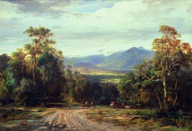 Geelong Gallery
Painting - On the Woods Point Road, BUVELOT, Louis, 1872
... On the Woods Point Road ...Oil on canvas -
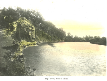 Lakes Entrance Historical Society
Postcard - Eagle Point bluff Eagle Point Victoria, Bulmer H D, 1920 c
Postcard lightly tinted of Mitchell River depicting the river at Eagle Point bluff with two men seated on bank, farm house in background Eagle Point VictoriaEagle Point, Mitchell River waterways, rivers, topography -
 Lakes Entrance Historical Society
Photograph - Jemmys Point, 1950c
Black and white photograph of the entrance, taken from lookout on Jemmys PointThe Entrance from Jemmy's Pointwaterways, ocean, navigation -
 Kew Historical Society Inc
Photograph - Mouth of the Hopkins River, Point Ritchie, Warrnambool, c.1926
... Mouth of the Hopkins River, Point Ritchie, Warrnambool ...Henry Beater Christian (1886-1962) , was a descendant of one of the earliest settler families in Kew. Employed at the Kew Asylum as a 'public servant', he was a skilled amateur photographer, photographing numerous scenes in Kew and on his travels around Victoria. The majority of his photographs date from 1916 to 1929. His finest photographs are housed in two photograph albums. Digital copy of a photograph from page 23 of the 47-page photograph album containing 261 gelatinous silver images, loaned by Diane Washfold with permission given to digitise and hold a copy in our collection. Henry Christian took a number of walking and rail trips, individually or with friends, around regional and rural Victoria during the 1920s. This photo is from a series of twelve photographs of parts of the west coast of Victoria, including Port Fairy and Warrnambool. The location in this photograph has been identified by Kathleen Gervasoni as the mouth of the Hopkins River, Point Ritchie, Warrnambool. henry beater christian (1886-1962), landscape photography, christian-washfold collection, photograph albums, hopkins river, point ritchie, warrnambool -
 Mt Dandenong & District Historical Society Inc.
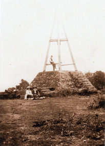
Photograph, The Mt Dandenong Trig Point
... The Mt Dandenong Trig Point ...Three people seated at Trig Point Mt Dandenong. (2 copies)mount dandenong, trig point -
 National Vietnam Veterans Museum (NVVM)
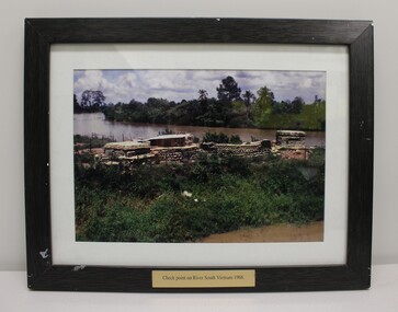
Photograph - Check Point on River South Vietnam 1968
This item commemorates the war in Vietnam ( 1962 - 1972)A colour photograph of a check point in South Vietnam in 1968.Check point on river South Vietnam 1968.south vietham, 1968, exon -
 Flagstaff Hill Maritime Museum and Village
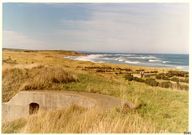
Photograph - Historical, Flagstaff Hill, Warrnambool Garrison Fortifications looking towards the Moyjil (Point Ritchie), 1970s
... Warrnambool Garrison Fortifications looking towards the ...The photograph shows the location of the concrete, horseshoe shaped gun emplacement erected for the cannons. It is part of the Historic Precinct on Flagstaff Hill. The area was accessed either through the space between the Lighthouses (through the cottage grounds) or a service entrance, past the iron huts used by the Lands Department. This photograph, a print, is one of a set of five that show the site of Flagstaff Hill. It is presumed to have been taken by John Lindsay, Founding Director of Flagstaff Hill Maritime Museum and Village. One of the photographs in the set has the pencil inscription "Photo J Lindsay". It was taken in the early 1970s during the initial stages of the development of Flagstaff Hill as a Museum and Maritime Village. The photographs belonged to the donor's grandparents, who lived in the Warrnambool district of Allansford/Naringal. The photograph is a record of the site and surrounds of Flagstaff Hill Maritime Museum and Village before its development and opening in 1975. It shows the east side of the Surfside Holiday Park in its earlier days. The photograph is significant for recording the location and condition of the original concrete cannon emplacement on the Hill.Coloured photograph, glassy print, one of a set of five. Photograph shows the original site of one of the gun emplacements for the cannons, cannons Historical, looking towards the Moyjil, ,Point Ritchie and overlooking Lady Bay, Warrnambool. The horseshoe shaped concrete gun emplacement is in the foreground on the grassed slopes overlooking the Bay. The site and ablution block of the Surfside Holiday Park is centre right. The left shows the sore of Lady Bay with the cliffs of the Southern Ocean in the distance. The photograph's paper has the printer's watermark on the back. The early 1970s scene is presumed to have been photographed by John Lindsay, Warrnambool.Label on the back: "FIRST GUN EMPLACEMENT LOOKING TOWARDS THE HOPKINS / This is the original site of one of the cannons overlooking the Bay. Access to this area could be between the light-houses (throught the cottage grounds), or a service entrance - past the iron huts used by Lands Department."flagstaff hill, flagstaff hill maritime museum and village, warrnambool, maritime museum, maritime village, great ocean road, shipwreck coast, 1970s, photograph, gun emplacement, surfside holiday park, lady bay, hopkins river, flagstaff hill site, john lindsay, concrete gun emplacement, cannon emplacement, original emplacement -
Glenelg Shire Council Cultural Collection
Photograph - Photographic print of a rephotographed photograph, c. 1970
Photographic print of a rephotographed photograph. Image shows view of harbour from Whalers Point/Bluff, Baths, piers, Cliff Street, Battery Point in Portland Victoria.Front: 'View from Whalers Point' - green ink