Showing 10 items matching "timber pedestrian bridge"
-
 Marysville & District Historical Society
THE TRIANGLE NEWS-VOL 37 NO 45-DECEMBER 3 2010
... ...timber pedestrian bridge...Marysville & District Historical Society 39 Darwin Street Marysville yarra-valley-and-the-dandenong-ranges marysville victoria australia great victorian bike ride yea township community recovery fund murrindindi shire council yea high school students riding campaign rain event toll on ut creek crossing timber pedestrian bridge alexandra bowling club local lady golfers marysville golf club marysville morning tea soapbox advertisements marysville & district historical society agm vbbra grant collection management mary kenealy melbourne ballet company marysville cultural community events tool box marysville police news THE TRIANGLE NEWS-VOL 37 NO 45-DECEMBER 3 2010 ...marysville, victoria, australia, great victorian bike ride, yea township, community recovery fund, murrindindi shire council, yea high school, students riding campaign, rain event toll on ut creek crossing, timber pedestrian bridge, alexandra bowling club, local lady golfers, marysville golf club, marysville morning tea, soapbox, advertisements, marysville & district historical society agm, vbbra grant, collection management, mary kenealy, melbourne ballet company, marysville cultural community, events tool box, marysville police news -
 Eltham District Historical Society Inc
Photograph, Fay Bridge, Wattletree Road Bridge, Eltham, c.Jan. 1990
... Shows Eltham Council sign notifying temporary closure of the bridge 19 Feb to 27 April 1990 for redecking. Illustrates the timber decking of the bridge and pedestrian footbridge extension on southern side....Eltham District Historical Society Inc 728 Main Rd Eltham melbourne Shows Eltham Council sign notifying temporary closure of the bridge 19 Feb to 27 April 1990 for redecking. Illustrates the timber decking of the bridge and pedestrian footbridge extension on southern side. ...Shows Eltham Council sign notifying temporary closure of the bridge 19 Feb to 27 April 1990 for redecking. Illustrates the timber decking of the bridge and pedestrian footbridge extension on southern side.fay bridge collection, 1990-01, wattletree road bridge -
 Eltham District Historical Society Inc
Photograph, Tess Justine (Nillumbik Shire Council), Murray's Bridge over the Diamond Creek, Eltham North, 19 Feb 2022
... timber bridge design of the early-to-mid 1920s. In c1990 Murray’s bridge was renovated with three recycled steel girders as part of a bike/pedestrian path in the reserve. ...timber bridge design of the early-to-mid 1920s. In c1990 Murray’s bridge was renovated with three recycled steel girders as part of a bike/pedestrian path in the reserve. ...Murray's Bridge over the Diamond Creek on the Diamond Creek Trail just prior to demolition and replacement with a new steel bridge. Heritage advice obtained by Nillumbik Shire Council, following a suggestion by the Eltham District Historical Society (EDHS), is that the original bridge appears to have been a simplified version of the Country Roads Board’s (CRB) standard timber bridge design of the early-to-mid 1920s. In c1990 Murray’s bridge was renovated with three recycled steel girders as part of a bike/pedestrian path in the reserve. During these alterations many parts of the bridge were removed, and some were replaced. Heritage advice indicates the condition of Murray’s bridge is poor. The remaining original parts are all in poor condition, with severe weathering, splitting and rot, especially to the stringers retained on the bridge. Heritage advice is that Murray’s Bridge does not have sufficient significance in the cultural history of the Nillumbik area to warrant inclusion in the Nillumbik Shire Heritage Overlay and also does not have sufficient significance as a rare survivor to warrant inclusion in the Nillumbik Shire Heritage Overlay. There are no indications in the historical record that this site was individually important to the cultural history of this area. EDHS is comfortable with the heritage advice provided to Council and has worked closely on this project with Council. EDHS has suggested some of the removed timbers be used in the vicinity of the bridge for landscaping and possibly seating, so as to retain these remnants close to the site of the original bridge, which is the last old timber bridge along the lower reaches of the Diamond Creek. Mary (Sweeney) Murray and John Wright Murray selected 80 acres, Lot C Section 16 and Lot 5 Section 17 Parish of Nillumbik, under an occupation license in 1866. John died in 1867 and freehold was granted to his son John in 1873. The farm was known as ‘Laurel Hill’. John Junior was an Eltham Shire councillor and sometime president from 1887 up until 1897. He added Lot A Section 16 to the farm in ca1888. John and his younger brother James arranged to rent/purchase Lot B Section 17, across Diamond Creek to the west, in ca1900. It appears that John and James farmed separately for a few years, with a new homestead built for James ad family on the high point of Lot B Section 17 in ca1910. John sold off Lot 5 Section 17 in 1912. When John died in 1912 James took over the land on both sides of the Diamond Creek. The old homestead on the west side of the Creek disappeared. A farm bridge over Diamond Creek from this period may have been located close to the northern boundary of the farm. John Langlands, owner of the farm known as ‘Ihurst’ on the west side of Diamond Creek to the south of the Murray’s land, died in 1907. In 1909 his land was then subdivided into 100 lots to become the ‘Glen Park Estate’. Other similar subdivisions of nineteenth century farms around Eltham in this period included the ‘Franktonia (or Beard’s) Estate’ to the northeast and ‘Bonsack’s Estate’ between Eltham and Greensborough. Soon after the opening of the railway extension line from Eltham to Hurstbridge in 1912, Glen Park and nearby residents including James Murray agitated for a railway station or siding to be located half-way between Eltham and Hurstbridge, so that the Glen Park residents who used the railway daily did not have to walk into the Eltham or Hurstbridge stations. Some believed Coleman’s Corner (opposite Edendale Farm) was an appropriate spot for the platform. James Murray was among those who thought the railway should be located on his land, closer to half-way between Eltham and Hurstbridge stations. The Railways Commissioners warned that the locals would have to fund these works themselves. The Glen Park Estate residents initially had difficulty accessing Eltham by road, with only an old low-level bridge over Diamond Creek at the south end of their estate. A new timber trestle bridge across the creek, now on Wattletree Road, was opened in 1915. Road access to the north was gained in 1927 when the new Murray’s Road, which crossed the Murray’s land, was built. Residents continued to agitate for a Glen Park station. By 1926 the Railways Commissioners’ preferred site was on the Murray’s land. They arranged an estimate of cost of a full-length platform. The estimate was too much for the locals, who in 1928 argued unsuccessfully for a shorter and hence cheaper platform. By 1929 Murray had agreed to donate the land, but the locals would still have to fund the works. Murray decided, unilaterally it would appear, to commence work on a timber trestle road bridge over Diamond Creek to link the new Murray Road to the proposed station. Late in 1929 he stopped work on the bridge, for reasons unknown, but started work again and completed the bridge in 1931. There is no further newspaper evidence of the campaign for the Glen Park station until 1939, when Murray and another local, Mr Maxwell, met the Railways Commissioner. The Glen Park locale now included 45 homes on the west side of the creek and 20 on the Eltham side. Most of the residents used the train every day. The Commissioner remained adamant that only a full-length platform could be built for safety reasons. It appears the campaign dissolved at this point. The increasing move to cars may have had an impact. There is no evidence of Murray’s bridge ever being connected to Murray’s Road, or of it having wide use for any purpose by locals. James Murray died in 1947 and the farm was taken over by his son James (Jim). Jim started to sell off parts of the farm in the 1980s, retaining a few acres around the ca1910 homestead and building a new house there. Recreation reserves were established along the creek. In ca1990 Murray’s bridge was renovated with steel girders as part of a bike/pedestrian path in the reserve. The old farmhouse was demolished in ca2014. * * * A theory posted on local community Facebook groups was that the bridge was built in the 1860s and was built to be more robust than was necessary for the movement of cows from one side of the creek to the other. It was suggested the robustness was necessary to support the weight of gold ore being transferred from a mine on Murray’s land to a railway siding near Murrays Bridge (presumably for transfer and processing at Diamond Creek). Perhaps this may have been one of the motivators for Murray, who really knows? Knowing when mining operations ceased on his land and how that fits the overall timeline would be useful but at the time the bridge was built, local gold production was minimal at best. The known facts are: • The railway line came to Eltham in 1902. • The extension of the railway from Eltham to Hurstbridge was constructed in 1912 so no railway line even existed through Murray's property until 1912 and the Victorian Railways maps at the time show no such siding on Murray’s property. • In 1923 a new company was formed in anticipation of the old Diamond Creek Gold Mine being re-opened. The mine had been previously closed and flooded. It was noted in the press at the time that the mine was within a mile of the railway. Nothing really came of this. • Construction of Murrays Bridge was commenced by James Murray in early 1929 in anticipation of a proposed flag station being nominated on his land, but work ceased shortly afterwards. The proposed flag station was commonly referred to as Glen Park as the residents of the Glen Park Estate wanted Option 1, located near them with the platform adjacent to Colemans corner. This was probably never going to fly as it was virtually in eyesight of Eltham station. Allandale Road was the third option, but the Commissioners' preferred option was No. 2 - on Murray's property. • The Railway Commissioners were not going to finance any such station and the works had to be funded by private landowners and residents, hence Murray investing in this himself. • Murray recommenced work two years later and finished his bridge in 1931 but unfortunately for him, the proposed flag station never eventuated. The bluestone siding you reference may well have been built by Murray as part of the proposed station platform. • Up until then, apart from the Main Road bridge, which was washed away in 1924, virtually all local crossings over the Diamond Creek were low lying bridges – Kaylocks Bridge at Brougham Street, Diamond Street bridge, Glen Park Road bridge. It is expected that Murray also had a low-lying bridge to connect his land either side of the creek. These were all washed away or severely damaged multiple times in the 1920s. Lessons were learnt, and Murrays Bridge appears to have been built in accordance with Country Road Board standards of the time. Flood damage was ongoing, and even more recently constructed raised bridges kept getting washed away, e.g., the new Wattle Tree Road bridge in 1958 just months after completion. Murray’s bridge was reinforced with steel some 30 years ago presumably to provide additional floodwater resistance, given the history of bridges disappearing in floodwaters. • In March 1932 it was reported in the Advertiser that there were still some prospectors operating around Eltham North who apart from further scarring the face of the earth over the previous two years had gained significant experience but little gold - hardly a driving factor for constructing a dedicated railway siding and bridge to transfer gold ore. It is far more probable that James Murray was hoping to have the railway station located on his property and invested his money by building the bridge to lead to it as well as a station platform. Had the station eventuated, it may well have driven up the value of his land for subdivision and new housing estates like the Glen Park Estate. That did not eventuate. Whilst the bridge was indeed old (90 years), the core structure being completed in 1931, it had been modified substantially from original and hence had no significant historic value – i.e., it was not a representative example of its type, construction, and age. Given that the bridge was not worthy of saving, the Eltham District Historical Society with Council’s support, and the Eltham Woodworkers group endeavoured to see what suitable sized timbers were salvageable to fabricate a commemorative seat. Unfortunately, the experts at the Woodworkers group were unable to salvage any suitable length/width timbers to fabricate the seat due to the presence of rot. Last remaining wooden trestle bridge on the Diamond Creek Trail just prior to demolition and replacementBorn digital image (27)diamond creek (creek), diamond creek trail, murrays bridge, ‘laurel hill’, john wright murray, mary (sweeney) murra, john murray jnr, james murray, john langlands, ‘ihurst’, ‘glen park estate’, beard's estate, franktonia, bonsack's estate, glen park estate, glen park railway station -
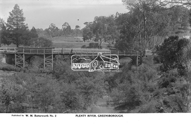 Eltham District Historical Society Inc
Photograph, The Rose Stereograph Company, Plenty River, Greensborough, c.1939
... View looking northwest along the Plenty River towards the original bluestone Greensborough Bridge (since demolished). A timber pedestrian footbridge added after construction is visible with two people crossing. ...Eltham District Historical Society Inc 728 Main Rd Eltham melbourne View looking northwest along the Plenty River towards the original bluestone Greensborough Bridge (since demolished). A timber pedestrian footbridge added after construction is visible with two people crossing. ...View looking northwest along the Plenty River towards the original bluestone Greensborough Bridge (since demolished). A timber pedestrian footbridge added after construction is visible with two people crossing. In the distance is a wide flat verge, now present day Carter Reserve and on the far side seven men digging and a set of terraced steps dug out in the earth bank. Present day Pioneer Reserve is to the right of the river in foreground. This glass plate negative was used to manufacture postcards (1:1 printing) for commercial sale by the Rose Sterograph Company and its subsidiaries. George Rose founded the Rose Stereograph Company in 1880 and was joined by Herbert (Bert) Cutts in the early 20th Century. The pair formed a lifetime working partnership and strong personal friendship. Assisted by George’s two sons, Herbert George and Walter, and later by Neil Cutts, the Rose Stereograph Company continued its operations for more than 140 years. The company was initially built on stereographs, but as cinema took over and stereographs fell out of fashion, the Rose Stereograph Company developed Australia’s first commercially viable photographic postcard business. Specialising in postcards of iconic historical moments and significant landmarks, The Rose Stereograph Company became a staple of the Australian travel industry.This remarkable collection of glass plate negatives, transparencies, and postcards – arguably Australia’s most significant photography collection outside of public hands – has been passed down through the generations, surviving war, relocation, and the harsh Victorian climate. The historic Rose Stereograph collection is the culmination of George Rose’s dream of capturing and preserving precious moments in time and remains the legacy of the Rose and Cutts families. It is with great sadness that the Cutts family says goodbye to a collection that spans five generations and 140 years. The Cutts family understands that for these historically important pieces to rest with one family is to deny others the pleasure of their custodianship.Glass Plate Negative Size: 9 x 14 cmPlenty River, Greensborough, Published by W. M. Butterworh No. 2postcard, travel, rose stereograph company, glass plate negative, greensborough, carter reserve, footbridge, greensborough bridge, main road, plenty river, w. m. butterworth, pioneer reserve, construction, peter and elizabeth pidgeon collection -
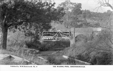 Eltham District Historical Society Inc
Photograph, The Rose Stereograph Company, The Wading Pool, Greensborough, c.1939
... View looking northeast across the wading pool set into the Plenty River towards the original bluestone Greensborough Bridge (since demolished). A timber pedestrian footbridge added after construction is visible on the far side of the bridge through the arch and beyond to the hillside which is now present day Pioneer Reserve. ...Eltham District Historical Society Inc 728 Main Rd Eltham melbourne View looking northeast across the wading pool set into the Plenty River towards the original bluestone Greensborough Bridge (since demolished). A timber pedestrian footbridge added after construction is visible on the far side of the bridge through the arch and beyond to the hillside which is now present day Pioneer Reserve. ...View looking northeast across the wading pool set into the Plenty River towards the original bluestone Greensborough Bridge (since demolished). A timber pedestrian footbridge added after construction is visible on the far side of the bridge through the arch and beyond to the hillside which is now present day Pioneer Reserve. This glass plate negative was used to manufacture postcards (1:1 printing) for commercial sale by the Rose Sterograph Company and its subsidiaries. George Rose founded the Rose Stereograph Company in 1880 and was joined by Herbert (Bert) Cutts in the early 20th Century. The pair formed a lifetime working partnership and strong personal friendship. Assisted by George’s two sons, Herbert George and Walter, and later by Neil Cutts, the Rose Stereograph Company continued its operations for more than 140 years. The company was initially built on stereographs, but as cinema took over and stereographs fell out of fashion, the Rose Stereograph Company developed Australia’s first commercially viable photographic postcard business. Specialising in postcards of iconic historical moments and significant landmarks, The Rose Stereograph Company became a staple of the Australian travel industry.This remarkable collection of glass plate negatives, transparencies, and postcards – arguably Australia’s most significant photography collection outside of public hands – has been passed down through the generations, surviving war, relocation, and the harsh Victorian climate. The historic Rose Stereograph collection is the culmination of George Rose’s dream of capturing and preserving precious moments in time and remains the legacy of the Rose and Cutts families. It is with great sadness that the Cutts family says goodbye to a collection that spans five generations and 140 years. The Cutts family understands that for these historically important pieces to rest with one family is to deny others the pleasure of their custodianship.Glass Plate Negative Size: 9.1 x 14 cmThe Wading Pool, Greensborough, Published by W. M. Butterworh No. 8postcard, travel, rose stereograph company, glass plate negative, greensborough, footbridge, greensborough bridge, main road, plenty river, w. m. butterworth, pioneer reserve, wading pool, peter and elizabeth pidgeon collection -
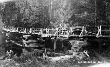 Eltham District Historical Society Inc
Negative - Photograph, Log bridge over Pheasant Creek, Kinglake, c.1920
... Postcard view of pedestrian log bridge in Kinglake National Park. The log bridge over Johnston's Creek is said to have been built to allow the timber tramline to cross the creek. ...Eltham District Historical Society Inc 728 Main Rd Eltham melbourne Postcard view of pedestrian log bridge in Kinglake National Park. The log bridge over Johnston's Creek is said to have been built to allow the timber tramline to cross the creek. ...Postcard view of pedestrian log bridge in Kinglake National Park. The log bridge over Johnston's Creek is said to have been built to allow the timber tramline to cross the creek. The bridge was destroyed in the 1926 bushfires. Other sources describe this bridge being located at Pheasant Creek (between Kinglake West and Kinglake Central) and that it was built by Mr Munro, the owner of the sawmill.This photo forms part of a collection of photographs gathered by the Shire of Eltham for their centenary project book,"Pioneers and Painters: 100 years of the Shire of Eltham" by Alan Marshall (1971). The collection of over 500 images is held in partnership between Eltham District Historical Society and Yarra Plenty Regional Library (Eltham Library) and is now formally known as 'The Shire of Eltham Pioneers Photograph Collection.' It is significant in being the first community sourced collection representing the places and people of the Shire's first one hundred years.Digital image 4 x 5 inch B&W Neg 1 printshire of eltham pioneers photograph collection, kinglake, log bridge, bridge, mr. munro, timber tramway, pheasant creek -
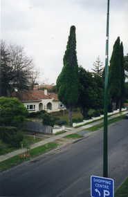 Whitehorse Historical Society Inc.
Photograph, View from Mitcham Pedestrian Bridge, 1/07/2000 12:00:00 AM
... pedestrian overpass on Whitehorse Road, Mitcham, looking north-east towards the Mitcham Shopping Centre.- North - side. House with Spanish taste belonged to Mr. Peake of Peake and Cox, the timber yard directly across Whitehorse Road from this house which became the new site of St.John's Roman Catholic Primary School. This house was on the corner of Whitehorse Road and Albert Street. Upon the sale of the timber yard and mill the catholic church the house was also sold to the church and was occupied as a residence for the school's teaching Sister's. (House since demolished) View from Mitcham Pedestrian Bridge ...Coloured photo from the pedestrian overpass on Whitehorse Road, Mitcham, looking north-east towards the Mitcham Shopping Centre.- North - side. House with Spanish taste belonged to Mr. Peake of Peake and Cox, the timber yard directly across Whitehorse Road from this house which became the new site of St.John's Roman Catholic Primary School. This house was on the corner of Whitehorse Road and Albert Street. Upon the sale of the timber yard and mill the catholic church the house was also sold to the church and was occupied as a residence for the school's teaching Sister's. (House since demolished)whitehorse road, mitcham, pedestrian overpass -
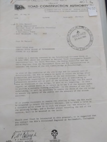 Peterborough History Group
Document - Three letters pertaining to the retention of the Old Bridge
... bridge for pedestrian purposes, or part of the old bridge as a fishing platform. These letters are part of the correspondence re an organisation taking responsibility for the ongoing maintenance so the old bridge could be retained. The old bridge was constructed of locally sourced timber ...Upon confirmation that a new bridge was to be built, there was some discussion about the possibility of retaining the old bridge for pedestrian purposes, or part of the old bridge as a fishing platform. These letters are part of the correspondence re an organisation taking responsibility for the ongoing maintenance so the old bridge could be retained.The old bridge was constructed of locally sourced timber and was such an important structure to the town when built. Its sentimental value saw locals attempt (although unsuccessfully) to retain the old bridge.Two A4 Typewritten letters, one from the Road Construction Authority to the National Trust Australia, the other from the Department of Conservation Forests & Lands to Mr John Irvine. And one hand written letter.RCA letter is stamped "Received 22 Aug 1985", Dept of Conservation Forests & Lands has a pencilled phone no inscribed.peterborough, curdies river bridge, old peterborough bridge, department of conservation forest & lands, road construction authority -
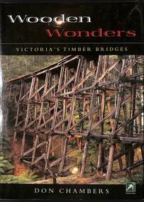 Victorian Railway History Library
Book, Chambers, Don, Wooden Wonders: Victoria's Timber Bridges, 2006
... Bridges - Victoria - Design and construction Bridges - Victoria - history A history of wooden bridges in Victoria, rail, road and pedestrian. index, ill, maps, p.207. Wooden Wonders: Victoria's Timber Bridges Book Chambers, Don Hyland House ...A history of wooden bridges in Victoria, rail, road and pedestrian.index, ill, maps, p.207.A history of wooden bridges in Victoria, rail, road and pedestrian.bridges - victoria - design and construction, bridges - victoria - history -
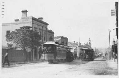 Melbourne Tram Museum
Photograph - Cable trams Bridge Road, Richmond, c1910s
... Bridge Road hill looking east. The trams are adjacent the National Bank of Australasia building on the east bound side and a 'Hail Cars Here' sign is fixed to a timber lamp post on the city bound side. In the midground are the Richmond Town Hall clock tower, several more cable trams, pedestrians...Bridge Road hill looking east. The trams are adjacent the National Bank of Australasia building on the east bound side and a 'Hail Cars Here' sign is fixed to a timber lamp post on the city bound side. In the midground are the Richmond Town Hall clock tower, several more cable trams, pedestrians ...Photograph shows two loaded cable trams about to pass each other on the Bridge Road hill looking east. The trams are adjacent the National Bank of Australasia building on the east bound side and a 'Hail Cars Here' sign is fixed to a timber lamp post on the city bound side. In the midground are the Richmond Town Hall clock tower, several more cable trams, pedestrians and horse drawn carts.Yields information about trams on Bridge Road, Richmond Black and white photograph with note on rear. In ink: "TMSV archive (crossed out), Car 13 Bridge Road Richmond"bridge road, richmond, hail cars here, richmond town hall