Showing 151 items matching "topographic map"
-
 Sunshine and District Historical Society Incorporated
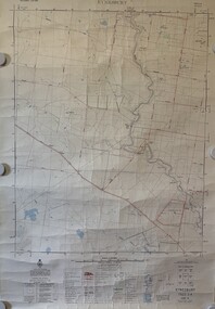
Map - Sydenham West Topographic Map, Vicmap, 1977
... Sydenham West Topographic Map...... Topographic... Map...Printed topographic map of the Sydenham West region...Sydenham West 7822-4-2 Zone 55 1:25000 1977 Topographic Map...Sydenham West Topographic Club Topographic Map Document Sydenham West 7822-4-2 Zone 55 1:25000 1977 Topographic Map Printed topographic map of the Sydenham West region Map Sydenham West Topographic Map Vicmap ...Sydenham West 7822-4-2 Zone 55 1:25000 1977 Topographic Mapsydenham west topographic club, topographic, map document -
 Bendigo Military Museum
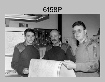
Photograph - First Topographic Map Printed on Speedmaster Press - Army Survey Regiment, Fortuna, Bendigo, c1992
... First Topographic Map Printed on Speedmaster Press - Army Survey Regiment, Fortuna, Bendigo. ...First Topographic Map Printed on Speedmaster Press - Army Survey Regiment, Fortuna, Bendigo. ...This is a photograph of the Director Survey - COL Simon Lemon, CO Army Svy Regt - LTCOL Bob McHenry and probably OC Litho - MAJ Terry Lord inspecting the 1St topographic map printed on the new Heidelberg Speedmaster 102 Printing Press in c1992. ...This is a photograph of three senior RASvy officers inspecting the first topographic map printed on the Heidelberg Speedmaster 102 Printing Press in Lithographic Squadron, Army Survey Regiment, Fortuna, Bendigo, c1992. ...Photograph First Topographic Map Printed on Speedmaster Press - Army Survey Regiment, Fortuna, Bendigo. ...This is a photograph of the Director Survey - COL Simon Lemon, CO Army Svy Regt - LTCOL Bob McHenry and probably OC Litho - MAJ Terry Lord inspecting the 1St topographic map printed on the new Heidelberg Speedmaster 102 Printing Press in c1992. *Estimated date based on the Director’s and CO’s period of appointment. The computer-controlled five colour lithographic offset printing press provided the Royal Australian Survey Corps vastly improved printing capability, as the five colours for a standard topographic map was printed in a single pass. The print room was named Wayzgoose Hall after a medieval printing house festival. Wayzgoose Hall and the Speedmaster printing capability was commissioned by the Commander of the 3rd Military District BRIG P. Davies AM, ADC on Wednesday 27th June 1990. This occasion is covered in more detail in page 145 of Valerie Lovejoy’s book 'Mapmakers of Fortuna – A history of the Army Survey Regiment’ ISBN: 0-646-42120-4. Colonel Simon Lemon was Director of the Royal Australian Survey Corps from January 1991 to June 1996.This is a photograph of three senior RASvy officers inspecting the first topographic map printed on the Heidelberg Speedmaster 102 Printing Press in Lithographic Squadron, Army Survey Regiment, Fortuna, Bendigo, c1992. The photograph is on 35mm black and white negative film and was scanned at 96 dpi. It is part of the Army Survey Regiment’s Collection. No personnel are identified. royal australian survey corps, rasvy, army survey regiment, army svy regt, fortuna, asr -
 Sunshine and District Historical Society Incorporated
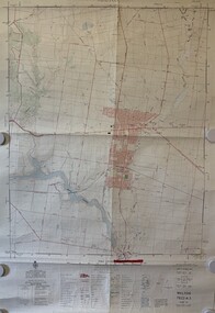
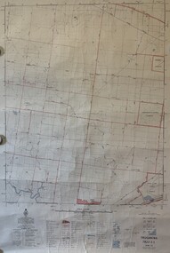
Map - Melton Topographic Map, Vicmap, 1979
... Melton Topographic Map...Printed topographic map of the Melton region...Melton 7822-4-3 Zone 55 1:25000 1979 Topographic Map...Melton Map Melton 7822-4-3 Zone 55 1:25000 1979 Topographic Map Printed topographic map of the Melton region Map Melton Topographic Map Vicmap ...Melton 7822-4-3 Zone 55 1:25000 1979 Topographic Mapmelton, map -
 Sunshine and District Historical Society Incorporated
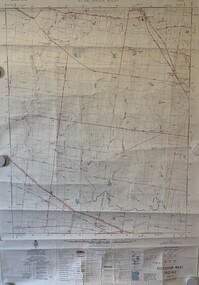
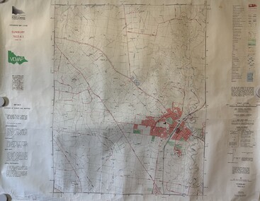
Map - Sunbury Topographic Map, Vicmap, 1989
... Sunbury Topographic Map...Printed topographic map of the Sunbury region...Sunbury 7822-4-1 Zone 55 1:25000 1989 Topographic Map...Sunbury Map Sunbury 7822-4-1 Zone 55 1:25000 1989 Topographic Map Printed topographic map of the Sunbury region Map Sunbury Topographic Map Vicmap ...Sunbury 7822-4-1 Zone 55 1:25000 1989 Topographic Mapsunbury, map -
 Sunshine and District Historical Society Incorporated
Map - Eynesbury Topographic Map, Vicmap, 1982
... Eynesbury Topographic Map...Printed topographic map of the Eynesbury region...Eynesbury 7822-3-2 Zone 55 1:25000 1982 Topographic Map...Eynesbury Map Eynesbury 7822-3-2 Zone 55 1:25000 1982 Topographic Map Printed topographic map of the Eynesbury region Map Eynesbury Topographic Map Vicmap ...Eynesbury 7822-3-2 Zone 55 1:25000 1982 Topographic Mapeynesbury, map -
 Stawell Historical Society Inc
Map, Topographic Map Stawell North
... Topographic Map Stawell North...Topographic Map 1:25000 Coloured 1990...Stawell Historical Society Inc 46 Longfield St Stawell grampians Mapping Stawell North 7423-1-N Topographic Map 1:25000 Coloured 1990 Topographic Map Stawell North Map ...Topographic Map 1:25000 Coloured 1990Stawell North 7423-1-Nmapping -
Stawell Historical Society Inc
Map, Topographic Map Stawell South
... Topographic Map Stawell South...Topographic Map 1:25000 Coloured 1990...Stawell Historical Society Inc 46 Longfield St Stawell grampians Mapping Stawell South 7423-1-S Topographic Map 1:25000 Coloured 1990 Topographic Map Stawell South Map ...Topographic Map 1:25000 Coloured 1990Stawell South 7423-1-Smapping -
Stawell Historical Society Inc
Map, Topographic Map Callawadda South
... Topographic Map Callawadda South...Topographic Map 1:25000 Coloured 1990...Stawell Historical Society Inc 46 Longfield St Stawell grampians Mapping Callawadda South 7424-2-S Topographic Map 1:25000 Coloured 1990 Topographic Map Callawadda South Map ...Topographic Map 1:25000 Coloured 1990Callawadda South 7424-2-Smapping -
Stawell Historical Society Inc
Map, Topographic Map Ararat North
... Topographic Map Ararat North...Topographic Map 1:25000 Coloured 1990...Stawell Historical Society Inc 46 Longfield St Stawell grampians Mapping Ararat North 7423-2-N Topographic Map 1:25000 Coloured 1990 Topographic Map Ararat North Map ...Topographic Map 1:25000 Coloured 1990Ararat North 7423-2-Nmapping -
Stawell Historical Society Inc
Map, Topographic Map Glenorchy North
... Topographic Map Glenorchy North...Topographic Map 1:25000 Coloured 1990...Stawell Historical Society Inc 46 Longfield St Stawell grampians Mapping Glenorchy North 7424-3-N Topographic Map 1:25000 Coloured 1990 Topographic Map Glenorchy North Map ...Topographic Map 1:25000 Coloured 1990Glenorchy North 7424-3-Nmapping -
Stawell Historical Society Inc
Map, Victorian Topographic Map Barton
... Victorian Topographic Map Barton...Topographic Map 1:25000 Coloured 1985...Stawell Historical Society Inc 46 Longfield St Stawell grampians Mapping Barton 7423-3-1 Zone 54 VicMap Topographic Map 1:25000 Coloured 1985 Victorian Topographic Map Barton Map ...Topographic Map 1:25000 Coloured 1985Barton 7423-3-1 Zone 54 VicMapmapping -
Stawell Historical Society Inc
Map, Victorian Topographic Map Fyans Creek
... Victorian Topographic Map Fyans Creek...Topographic Map 1:25000 Coloured 1985...Stawell Historical Society Inc 46 Longfield St Stawell grampians Mapping Fyans Creek 7423-4-4 Zone 54 VicMap Topographic Map 1:25000 Coloured 1985 Victorian Topographic Map Fyans Creek Map ...Topographic Map 1:25000 Coloured 1985Fyans Creek 7423-4-4 Zone 54 VicMapmapping -
Stawell Historical Society Inc
Map, Victorian Topographic Map Glenorchy
... Victorian Topographic Map Glenorchy...Topographic Map 1:25000 Coloured 1985...Stawell Historical Society Inc 46 Longfield St Stawell grampians Mapping Glenorchy 7424-3-2 Zone 54 VicMap Topographic Map 1:25000 Coloured 1985 Victorian Topographic Map Glenorchy Map ...Topographic Map 1:25000 Coloured 1985Glenorchy 7424-3-2 Zone 54 VicMapmapping -
Stawell Historical Society Inc
Map, Victorian Topographic Map Ledcourt
... Victorian Topographic Map Ledcourt...Topographic Map 1:25000 Coloured 1985...Stawell Historical Society Inc 46 Longfield St Stawell grampians Mapping Ledcourt 7424-3-3 Zone 54 VicMap Topographic Map 1:25000 Coloured 1985 Victorian Topographic Map Ledcourt Map ...Topographic Map 1:25000 Coloured 1985Ledcourt 7424-3-3 Zone 54 VicMapmapping -
Stawell Historical Society Inc
Map, Victorian Topographic Map Bellellen
... Victorian Topographic Map Bellellen...Topographic Map 1:25000 Coloured 1985...Stawell Historical Society Inc 46 Longfield St Stawell grampians Mapping Bellellen 7423-4-2 Zone 54 VicMap Topographic Map 1:25000 Coloured 1985 Victorian Topographic Map Bellellen Map ...Topographic Map 1:25000 Coloured 1985Bellellen 7423-4-2 Zone 54 VicMapmapping -
Stawell Historical Society Inc
Map, Victorian Topographic Map Illawarra
... Victorian Topographic Map Illawarra...Topographic Map 1:25000 Coloured 1978...Stawell Historical Society Inc 46 Longfield St Stawell grampians Mapping Illawarra 7423-4-1 Topographic Map 1:25000 Coloured 1978 Victorian Topographic Map Illawarra Map ...Topographic Map 1:25000 Coloured 1978Illawarra 7423-4-1mapping -
Stawell Historical Society Inc
Map, Victorian Topographic Map Rupanyup
... Victorian Topographic Map Rupanyup...Topographic Map 1:100000 Coloured 1976...Stawell Historical Society Inc 46 Longfield St Stawell grampians Mapping Rupanyup 7424 Topographic Map 1:100000 Coloured 1976 Victorian Topographic Map Rupanyup Map ...Topographic Map 1:100000 Coloured 1976Rupanyup 7424mapping -
Stawell Historical Society Inc
Map, Victorian Topographic Map Ararat
... Victorian Topographic Map Ararat...Topographic Map 1:100000 Coloured 1966...Stawell Historical Society Inc 46 Longfield St Stawell grampians Mapping Ararat 7423 Topographic Map 1:100000 Coloured 1966 Victorian Topographic Map Ararat Map ...Topographic Map 1:100000 Coloured 1966Ararat 7423mapping -
 Sunshine and District Historical Society Incorporated
Map - Truganina Topographic Map, Vicmap, 1981
... Truganina Topographic Map...Printed topographic map of the Truganina region...Truganina Map Ballarat Road Eynesbury 7822-3-1 Zone 55 1:25000 1981Topographic Map Printed topographic map of the Truganina region Map Truganina Topographic Map Vicmap ...Eynesbury 7822-3-1 Zone 55 1:25000 1981Topographic Maptruganina, map, ballarat road -
 Greensborough Historical Society
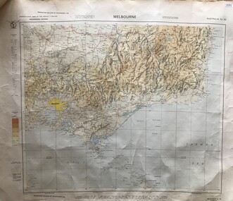
Map, Australia. Department of Minerals and Energy, Melbourne, topographic map, 1970_
... Melbourne, topographic map...A topographic map of Victoria with Melbourne as the centre. ...A pre-metric map, shows the Hume Highway travelling through towns such as Seymour and Benalla, now by-passed by the Hume Freeway. victoria - maps Map, printed in colour on one side. Melbourne, topographic map Map Australia. Department of Minerals and Energy ...A topographic map of Victoria with Melbourne as the centre. Provisional edition showing contours in feet. International map of the world [scale] 1:1,000,000. Prepared by the Department of Minerals and Energy, Canberra in 1970.A pre-metric map, shows the Hume Highway travelling through towns such as Seymour and Benalla, now by-passed by the Hume Freeway.Map, printed in colour on one side.victoria - maps -
Victorian Aboriginal Corporation for Languages
Map, Geographic Data Victoria, Vicmap topographic map index as at June 2000, 2000
... Vicmap topographic map index as at June 2000...Index to Vicmap topographic mapping, including 1:25 000 and 1:50 000 topographic maps, and Outdoor leisure series, compiled by the earlier bodies, Survey &? ...Victorian Aboriginal Corporation for Languages 33 Saxon Street Brunswick melbourne Victorian maps topographic maps maps Index to Vicmap topographic mapping, including 1:25 000 and 1:50 000 topographic maps, and Outdoor leisure series, compiled by the earlier bodies, Survey &? ...Index to Vicmap topographic mapping, including 1:25 000 and 1:50 000 topographic maps, and Outdoor leisure series, compiled by the earlier bodies, Survey &? Mapping Victoria, etc. Also indexes Royal Australian Survey Corps' 1:50 000 topographic mapping.mapsvictorian maps, topographic maps -
 Bendigo Military Museum
Manual - DRAFT SPECIFICATIONS FOR TOPOGRAPHIC MAP SERIES, Specifications for 1:50000 and 1:25000 maps produced in Australia, Circa 1973
... DRAFT SPECIFICATIONS FOR TOPOGRAPHIC MAP SERIES...These draft Specifications set out the Standards for the production of topographic maps within the Commonwealth of Australia at scales of 1:50000 and 1:25000 and are designed to satisfy the basic requirements of both civil and military map users....Specifications for 1:50000 and 1:25000 maps produced in Australia Manual DRAFT SPECIFICATIONS FOR TOPOGRAPHIC MAP SERIES Royal Ausralian Survey Corps National Mapping Council of Australia ...These draft Specifications set out the Standards for the production of topographic maps within the Commonwealth of Australia at scales of 1:50000 and 1:25000 and are designed to satisfy the basic requirements of both civil and military map users.Hard cover, cloth, Red, 11 Annexes, Supplementary documents.royal australian survey corps, rasvy, fortuna, army survey regiment, asr -
Beechworth Honey Archive
Topographic Map, Beechworth, Australia
... Topographic Map, Beechworth, Australia...Map includes Beechworth, Everton, Muirmungee, Wooragee and Eldorado. Topographic Map, Beechworth, Australia ...Map 1:50,000. Sheet 8225-111 Printed by Royal Australian Survey Corp, 1967. Map includes Beechworth, Everton, Muirmungee, Wooragee and Eldorado. -
Lakes Entrance Historical Society
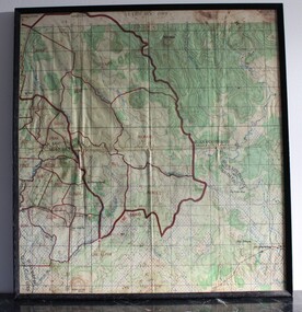
Map - Bogong Fire Complex Topographic Map Base Swifts Creek Sheet 8, GIS Unit Dept Primary Industry, 2003/1
... Bogong Fire Complex Topographic Map Base Swifts Creek Sheet 8...Lakes Entrance Historical Society 4 Marine Parade Lakes Entrance gippsland Grid represents 1,000 metre intervals of the Australian Map Grid (AMG) Australian Geoletic Datum Topography Fires Waterways Forest Roads and Streets Map shows fire complex of East Gippsland names, towns, rivers and forest tracks Map Bogong Fire Complex Topographic Map Base Swifts Creek Sheet 8 GIS Unit Dept Primary Industry ...Grid represents 1,000 metre intervals of the Australian Map Grid (AMG) Australian Geoletic DatumMap shows fire complex of East Gippsland names, towns, rivers and forest trackstopography, fires, waterways, forest, roads and streets -
 Sunshine and District Historical Society Incorporated
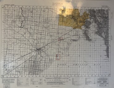
Map - Melbourne Topographical Map No 848 Zone 7, 1930
... Melbourne Topographical Map No 848 Zone 7...Laminated Melbourne Topographical Map No 848 Zone 7 showing Melbourne : Footscray : Williamstown : Maidstone : Sunshine : Deer Park : Laverton : Werribee : Port Phillip Map...Melbourne Topographical Map No 848 Zone 7|Point Cook Airfield, Laverton Airfield and No 1 Stores Tottenham marked on the map....Laminated Melbourne Topographical Map No 848 Zone 7 showing Melbourne : Footscray : Williamstown : Maidstone : Sunshine : Deer Park : Laverton : Werribee : Port Phillip Map Map Melbourne Topographical Map No 848 Zone 7 ...Melbourne Topographical Map No 848 Zone 7|Point Cook Airfield, Laverton Airfield and No 1 Stores Tottenham marked on the map.melbourne, map -
 National Vietnam Veterans Museum (NVVM)
Map - Framed map, Xuyen Moc (SW)
... Part of a single sheet from the Vietnam 1:25 000 topographical map series (L7014) covering the area around the town of Xuyen Moc in the southern province of Phuoc Tuy (modern Ba Ria - Vung Tau). ...Square topographical map with district boundaries, vegetation and terrain features. ...Xuyen Moc Phuoc Tuy map Vungtau Vung tau Ba Ria Sheet 6430-11-SW/ Edition 2/Series L 8015 Square topographical map with district boundaries, vegetation and terrain features. ...Part of a single sheet from the Vietnam 1:25 000 topographical map series (L7014) covering the area around the town of Xuyen Moc in the southern province of Phuoc Tuy (modern Ba Ria - Vung Tau). Used during the war, this shows Areas of Operations given men's names.Square topographical map with district boundaries, vegetation and terrain features. Relief shown by contours. Has been laminated and framed.Sheet 6430-11-SW/ Edition 2/Series L 8015xuyen moc, phuoc tuy, map, vungtau, vung tau, ba ria -
Warrnambool RSL Sub Branch
BOB: Map France 1:100,000 AMIENS, AMIENS, Geographical Section, General Staff, No 2364. October 1915; Ordnance Survey 1916; Minor Corrections 01/10/1916
... Topographical map. Full colour ...(Bob) Snape, Reg No 8651, enlisted as a Stretcher Bearer in 1915 but, because of his secretarial skills was employed in HQ positions as soon as he arrived in France and as a stenographer who worked as Confidential Clerk to General Sir John Monash from June to December 1918; and subsequently, for General Sir Tread more Snape Collection Topographical map. Full colour AMIENS BOB: Map France 1:100,000 AMIENS ...Original Item souvenired from possibly Australian Corps HQ, probably between the Armistice, 11 November 1918, and June 1919, when the Staff Sergeant R.O.(Bob) Snape was repatriated.The donor, Staff Sergeant R.O. (Bob) Snape, Reg No 8651, enlisted as a Stretcher Bearer in 1915 but, because of his secretarial skills was employed in HQ positions as soon as he arrived in France and as a stenographer who worked as Confidential Clerk to General Sir John Monash from June to December 1918; and subsequently, for General Sir Tread moreTopographical map. Full colour snape collection -
 Running Rabbits Military Museum operated by the Upwey Belgrave RSL Sub Branch
Map
... Topographic map of Nui Dat...Running Rabbits Military Museum operated by the Upwey Belgrave RSL Sub Branch 1 Mast Gully Road Upwey melbourne Maps Vietnam Army Topographic map of Nui Dat Map ...Topographic map of Nui Datmaps, vietnam, army -
 Kiewa Valley Historical Society
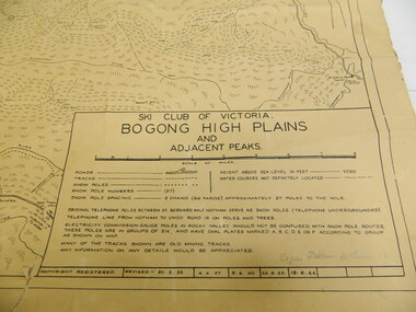
Map - Topographical, Ski Club of Victoria Bogong High Plains and Adjacent Peaks, Early 1930's
... Map - Topographical ...topographic map; kiewa valley; ryder family; high plains of victoria...The map is an early topographic map used by farmers living in the Kiewa Valley. ...This map has been in the Ryder family for approx. 70 years. Probably used when bush walking and skiing in the early days on the Bogong High Plains. The Ryder family are farmers in the Kiewa Valley and were involved in taking their cattle up to the Bogong High Plains where they had a lease. The State Electricity Commission of Victoria constructed the Kiewa Hydro Electric Scheme opening up the area during the 1940's and 1950's. This type of map is an early one, used by people in the Kiewa Valley and possibly by surveyors prior to construction.The map is an early topographic map used by farmers living in the Kiewa Valley. It is historically significant as these people were involved in taking cattle up to the High Plains during summer and may have been used for bush walking and skiing.This is a sepia coloured paper map which was originally printed copyright registered. It was revised in 20/6.33/4.4.37/8.4.40/24.8.43/19/6/54. It shows roads / tracks / snow poles / snow pole numbers (27) / Snow pole spacing (3 chains. 66 yards) approximately 27 poles to the mile / height above sea level in feet - 5280. Water courses not definitely located etc.Rocky Valley Dam (Kiewa Hydro Electric Scheme) has been drawn on the map by hand with a biro. There is a wooden rod at the top of the map.topographic map; kiewa valley; ryder family; high plains of victoria -
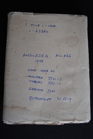 Anglesea and District Historical Society
Map, Royal Australian Survey Corps, Anglesea, Victoria, 1954
... ...topographic map...Anglesea and District Historical Society 5B McMillan Street Anglesea great-ocean-road anglesea map topographic map (See above) Anglesea, Victoria [cartographic material] produced by Royal Australian Survey Corps. ...Anglesea, Victoria [cartographic material] produced by Royal Australian Survey Corps. Colour; Scale [1:63,360] 1 mile to 1 inch; transverse Mercator projection; Sheet No. 866, Zone 7. Two stamps: 1. Rankine and Dobbie Pty Ltd. 2. Authorised for sale / Price 2/- / By Department of the Army Original date: November 1928.(See above)anglesea map, topographic map