Showing 151 items matching "topographic maps"
-
 Sunshine and District Historical Society Incorporated
Map - Melton Topographic Map, Vicmap, 1979
... Printed topographic map of the Melton region...Melton 7822-4-3 Zone 55 1:25000 1979 Topographic Map...Melton Map Melton 7822-4-3 Zone 55 1:25000 1979 Topographic Map Printed topographic map of the Melton region Map Melton Topographic Map Vicmap ...Melton 7822-4-3 Zone 55 1:25000 1979 Topographic Mapmelton, map -
 Sunshine and District Historical Society Incorporated
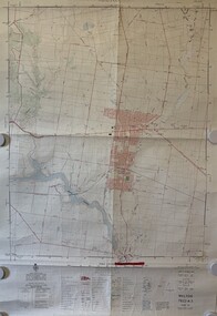
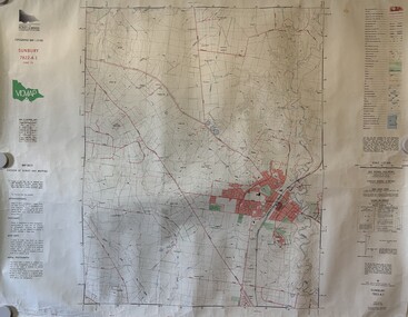
Map - Sunbury Topographic Map, Vicmap, 1989
... Printed topographic map of the Sunbury region...Sunbury 7822-4-1 Zone 55 1:25000 1989 Topographic Map...Sunbury Map Sunbury 7822-4-1 Zone 55 1:25000 1989 Topographic Map Printed topographic map of the Sunbury region Map Sunbury Topographic Map Vicmap ...Sunbury 7822-4-1 Zone 55 1:25000 1989 Topographic Mapsunbury, map -
 Sunshine and District Historical Society Incorporated
Map - Eynesbury Topographic Map, Vicmap, 1982
... Printed topographic map of the Eynesbury region...Eynesbury 7822-3-2 Zone 55 1:25000 1982 Topographic Map...Eynesbury Map Eynesbury 7822-3-2 Zone 55 1:25000 1982 Topographic Map Printed topographic map of the Eynesbury region Map Eynesbury Topographic Map Vicmap ...Eynesbury 7822-3-2 Zone 55 1:25000 1982 Topographic Mapeynesbury, map -
 Sunshine and District Historical Society Incorporated
Map - Sydenham West Topographic Map, Vicmap, 1977
... Printed topographic map of the Sydenham West region...Sydenham West 7822-4-2 Zone 55 1:25000 1977 Topographic Map...Sydenham West Topographic Club Topographic Map Document Sydenham West 7822-4-2 Zone 55 1:25000 1977 Topographic Map Printed topographic map of the Sydenham West region Map Sydenham West Topographic Map Vicmap ...Sydenham West 7822-4-2 Zone 55 1:25000 1977 Topographic Mapsydenham west topographic club, topographic, map document -
 Victorian Aboriginal Corporation for Languages
Map, Geographic Data Victoria, Vicmap topographic map index as at June 2000, 2000
... ...topographic maps...Index to Vicmap topographic mapping, including 1:25 000 and 1:50 000 topographic maps, and Outdoor leisure series, compiled by the earlier bodies, Survey &? ...Victorian Aboriginal Corporation for Languages 33 Saxon Street Brunswick melbourne Victorian maps topographic maps maps Index to Vicmap topographic mapping, including 1:25 000 and 1:50 000 topographic maps, and Outdoor leisure series, compiled by the earlier bodies, Survey &? ...Index to Vicmap topographic mapping, including 1:25 000 and 1:50 000 topographic maps, and Outdoor leisure series, compiled by the earlier bodies, Survey &? Mapping Victoria, etc. Also indexes Royal Australian Survey Corps' 1:50 000 topographic mapping.mapsvictorian maps, topographic maps -
 Sunshine and District Historical Society Incorporated
Map - Melbourne Topographical Map No 848 Zone 7, 1930
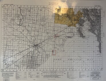
... Melbourne Topographical Map No 848 Zone 7...Laminated Melbourne Topographical Map No 848 Zone 7 showing Melbourne : Footscray : Williamstown : Maidstone : Sunshine : Deer Park : Laverton : Werribee : Port Phillip Map...Melbourne Topographical Map No 848 Zone 7|Point Cook Airfield, Laverton Airfield and No 1 Stores Tottenham marked on the map....Laminated Melbourne Topographical Map No 848 Zone 7 showing Melbourne : Footscray : Williamstown : Maidstone : Sunshine : Deer Park : Laverton : Werribee : Port Phillip Map Map Melbourne Topographical Map No 848 Zone 7 ...Melbourne Topographical Map No 848 Zone 7|Point Cook Airfield, Laverton Airfield and No 1 Stores Tottenham marked on the map.melbourne, map -
 National Vietnam Veterans Museum (NVVM)
Map - Framed map, Xuyen Moc (SW)
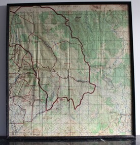
... Part of a single sheet from the Vietnam 1:25 000 topographical map series (L7014) covering the area around the town of Xuyen Moc in the southern province of Phuoc Tuy (modern Ba Ria - Vung Tau). ...Square topographical map with district boundaries, vegetation and terrain features. ...Xuyen Moc Phuoc Tuy map Vungtau Vung tau Ba Ria Sheet 6430-11-SW/ Edition 2/Series L 8015 Square topographical map with district boundaries, vegetation and terrain features. ...Part of a single sheet from the Vietnam 1:25 000 topographical map series (L7014) covering the area around the town of Xuyen Moc in the southern province of Phuoc Tuy (modern Ba Ria - Vung Tau). Used during the war, this shows Areas of Operations given men's names.Square topographical map with district boundaries, vegetation and terrain features. Relief shown by contours. Has been laminated and framed.Sheet 6430-11-SW/ Edition 2/Series L 8015xuyen moc, phuoc tuy, map, vungtau, vung tau, ba ria -
Warrnambool RSL Sub Branch
BOB: Map France 1:100,000 AMIENS, AMIENS, Geographical Section, General Staff, No 2364. October 1915; Ordnance Survey 1916; Minor Corrections 01/10/1916
... Topographical map. Full colour ...(Bob) Snape, Reg No 8651, enlisted as a Stretcher Bearer in 1915 but, because of his secretarial skills was employed in HQ positions as soon as he arrived in France and as a stenographer who worked as Confidential Clerk to General Sir John Monash from June to December 1918; and subsequently, for General Sir Tread more Snape Collection Topographical map. Full colour AMIENS BOB: Map France 1:100,000 AMIENS ...Original Item souvenired from possibly Australian Corps HQ, probably between the Armistice, 11 November 1918, and June 1919, when the Staff Sergeant R.O.(Bob) Snape was repatriated.The donor, Staff Sergeant R.O. (Bob) Snape, Reg No 8651, enlisted as a Stretcher Bearer in 1915 but, because of his secretarial skills was employed in HQ positions as soon as he arrived in France and as a stenographer who worked as Confidential Clerk to General Sir John Monash from June to December 1918; and subsequently, for General Sir Tread moreTopographical map. Full colour snape collection -
 Running Rabbits Military Museum operated by the Upwey Belgrave RSL Sub Branch
Map
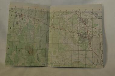
... Topographic map of Nui Dat...Running Rabbits Military Museum operated by the Upwey Belgrave RSL Sub Branch 1 Mast Gully Road Upwey melbourne Maps Vietnam Army Topographic map of Nui Dat Map ...Topographic map of Nui Datmaps, vietnam, army -
 Victorian Aboriginal Corporation for Languages
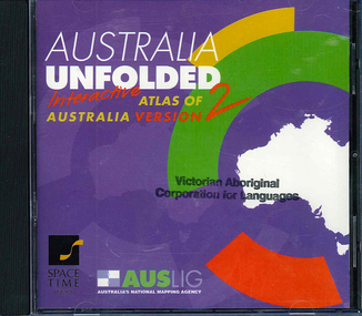
CD-ROM, Australian Surveying and Land Information Group, Australia unfolded : interactive atlas of Australia, 1996
... topographic maps...Victorian Aboriginal Corporation for Languages 33 Saxon Street Brunswick melbourne topographic maps Australian maps surveying CD-ROM Systems requirements: Macintosh version: Mac Plus (68030 or higher recommended), 5 MB hard disk space, 2 MB RAM (4 MB RAM recommended), CD-ROM drive, mouse, System 7 or above. "9314231106006"--CD-ROM. ...Systems requirements: Macintosh version: Mac Plus (68030 or higher recommended), 5 MB hard disk space, 2 MB RAM (4 MB RAM recommended), CD-ROM drive, mouse, System 7 or above. "9314231106006"--CD-ROM. System requirements: Windows version: IBM compatible 386 or higher, 5MB hard disk space, 4MB RAM (8MB RAM recommended), VGA monitor, CD-ROM drive, mouse, Windows 3.1 or above. In box (19 x 27 x 5 cm.).CD-ROMtopographic maps, australian maps, surveying -
 Sunshine and District Historical Society Incorporated
Map - Truganina Topographic Map, Vicmap, 1981
... Printed topographic map of the Truganina region...Truganina Map Ballarat Road Eynesbury 7822-3-1 Zone 55 1:25000 1981Topographic Map Printed topographic map of the Truganina region Map Truganina Topographic Map Vicmap ...Eynesbury 7822-3-1 Zone 55 1:25000 1981Topographic Maptruganina, map, ballarat road -
 Emerald Museum & Nobelius Heritage Park
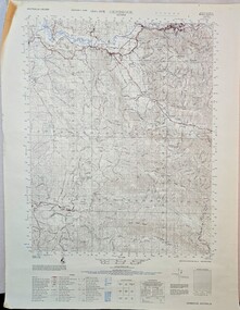
Map - Gembrook topographical map c1967, c1967
... Gembrook topographical map c1967...Gembrook topographical map c1967...Image of topographical map of the Gembrook district c1967...Emerald Museum & Nobelius Heritage Park 5 Crichton Rd Emerald yarra-valley-and-the-dandenong-ranges Gembrook Victoria/Australia 1:50,000/Edition 1 - AAS/Sheet 8022-111, Edition 1, Series 754/Legend/ Image of topographical map of the Gembrook district c1967 Gembrook topographical map c1967 Map Gembrook topographical map c1967 ...Image of topographical map of the Gembrook district c1967Gembrook Victoria/Australia 1:50,000/Edition 1 - AAS/Sheet 8022-111, Edition 1, Series 754/Legend/ -
Stawell Historical Society Inc
Map, Topographic Map Stawell North
... Topographic Map 1:25000 Coloured 1990...Stawell Historical Society Inc 46 Longfield St Stawell grampians Mapping Stawell North 7423-1-N Topographic Map 1:25000 Coloured 1990 Topographic Map Stawell North Map ...Topographic Map 1:25000 Coloured 1990Stawell North 7423-1-Nmapping -
Stawell Historical Society Inc
Map, Topographic Map Stawell South
... Topographic Map 1:25000 Coloured 1990...Stawell Historical Society Inc 46 Longfield St Stawell grampians Mapping Stawell South 7423-1-S Topographic Map 1:25000 Coloured 1990 Topographic Map Stawell South Map ...Topographic Map 1:25000 Coloured 1990Stawell South 7423-1-Smapping -
Stawell Historical Society Inc
Map, Topographic Map Callawadda South
... Topographic Map 1:25000 Coloured 1990...Stawell Historical Society Inc 46 Longfield St Stawell grampians Mapping Callawadda South 7424-2-S Topographic Map 1:25000 Coloured 1990 Topographic Map Callawadda South Map ...Topographic Map 1:25000 Coloured 1990Callawadda South 7424-2-Smapping -
Stawell Historical Society Inc
Map, Topographic Map Ararat North
... Topographic Map 1:25000 Coloured 1990...Stawell Historical Society Inc 46 Longfield St Stawell grampians Mapping Ararat North 7423-2-N Topographic Map 1:25000 Coloured 1990 Topographic Map Ararat North Map ...Topographic Map 1:25000 Coloured 1990Ararat North 7423-2-Nmapping -
Stawell Historical Society Inc
Map, Topographic Map Glenorchy North
... Topographic Map 1:25000 Coloured 1990...Stawell Historical Society Inc 46 Longfield St Stawell grampians Mapping Glenorchy North 7424-3-N Topographic Map 1:25000 Coloured 1990 Topographic Map Glenorchy North Map ...Topographic Map 1:25000 Coloured 1990Glenorchy North 7424-3-Nmapping -
Stawell Historical Society Inc
Map, Victorian Topographic Map Barton
... Topographic Map 1:25000 Coloured 1985...Stawell Historical Society Inc 46 Longfield St Stawell grampians Mapping Barton 7423-3-1 Zone 54 VicMap Topographic Map 1:25000 Coloured 1985 Victorian Topographic Map Barton Map ...Topographic Map 1:25000 Coloured 1985Barton 7423-3-1 Zone 54 VicMapmapping -
Stawell Historical Society Inc
Map, Victorian Topographic Map Fyans Creek
... Topographic Map 1:25000 Coloured 1985...Stawell Historical Society Inc 46 Longfield St Stawell grampians Mapping Fyans Creek 7423-4-4 Zone 54 VicMap Topographic Map 1:25000 Coloured 1985 Victorian Topographic Map Fyans Creek Map ...Topographic Map 1:25000 Coloured 1985Fyans Creek 7423-4-4 Zone 54 VicMapmapping -
Stawell Historical Society Inc
Map, Victorian Topographic Map Glenorchy
... Topographic Map 1:25000 Coloured 1985...Stawell Historical Society Inc 46 Longfield St Stawell grampians Mapping Glenorchy 7424-3-2 Zone 54 VicMap Topographic Map 1:25000 Coloured 1985 Victorian Topographic Map Glenorchy Map ...Topographic Map 1:25000 Coloured 1985Glenorchy 7424-3-2 Zone 54 VicMapmapping -
Stawell Historical Society Inc
Map, Victorian Topographic Map Ledcourt
... Topographic Map 1:25000 Coloured 1985...Stawell Historical Society Inc 46 Longfield St Stawell grampians Mapping Ledcourt 7424-3-3 Zone 54 VicMap Topographic Map 1:25000 Coloured 1985 Victorian Topographic Map Ledcourt Map ...Topographic Map 1:25000 Coloured 1985Ledcourt 7424-3-3 Zone 54 VicMapmapping -
Stawell Historical Society Inc
Map, Victorian Topographic Map Bellellen
... Topographic Map 1:25000 Coloured 1985...Stawell Historical Society Inc 46 Longfield St Stawell grampians Mapping Bellellen 7423-4-2 Zone 54 VicMap Topographic Map 1:25000 Coloured 1985 Victorian Topographic Map Bellellen Map ...Topographic Map 1:25000 Coloured 1985Bellellen 7423-4-2 Zone 54 VicMapmapping -
Stawell Historical Society Inc
Map, Victorian Topographic Map Illawarra
... Topographic Map 1:25000 Coloured 1978...Stawell Historical Society Inc 46 Longfield St Stawell grampians Mapping Illawarra 7423-4-1 Topographic Map 1:25000 Coloured 1978 Victorian Topographic Map Illawarra Map ...Topographic Map 1:25000 Coloured 1978Illawarra 7423-4-1mapping -
Stawell Historical Society Inc
Map, Victorian Topographic Map Rupanyup
... Topographic Map 1:100000 Coloured 1976...Stawell Historical Society Inc 46 Longfield St Stawell grampians Mapping Rupanyup 7424 Topographic Map 1:100000 Coloured 1976 Victorian Topographic Map Rupanyup Map ...Topographic Map 1:100000 Coloured 1976Rupanyup 7424mapping -
Stawell Historical Society Inc
Map, Victorian Topographic Map Ararat
... Topographic Map 1:100000 Coloured 1966...Stawell Historical Society Inc 46 Longfield St Stawell grampians Mapping Ararat 7423 Topographic Map 1:100000 Coloured 1966 Victorian Topographic Map Ararat Map ...Topographic Map 1:100000 Coloured 1966Ararat 7423mapping -
 Bendigo Military Museum
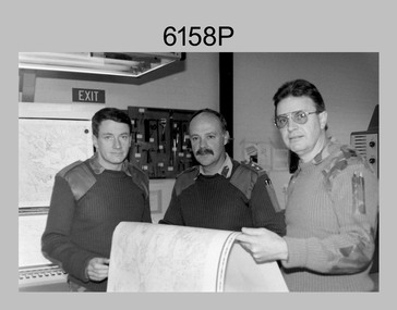
Photograph - First Topographic Map Printed on Speedmaster Press - Army Survey Regiment, Fortuna, Bendigo, c1992
... This is a photograph of the Director Survey - COL Simon Lemon, CO Army Svy Regt - LTCOL Bob McHenry and probably OC Litho - MAJ Terry Lord inspecting the 1St topographic map printed on the new Heidelberg Speedmaster 102 Printing Press in c1992. ...This is a photograph of three senior RASvy officers inspecting the first topographic map printed on the Heidelberg Speedmaster 102 Printing Press in Lithographic Squadron, Army Survey Regiment, Fortuna, Bendigo, c1992. ...Photograph First Topographic Map Printed on Speedmaster Press - Army Survey Regiment, Fortuna, Bendigo. ...This is a photograph of the Director Survey - COL Simon Lemon, CO Army Svy Regt - LTCOL Bob McHenry and probably OC Litho - MAJ Terry Lord inspecting the 1St topographic map printed on the new Heidelberg Speedmaster 102 Printing Press in c1992. *Estimated date based on the Director’s and CO’s period of appointment. The computer-controlled five colour lithographic offset printing press provided the Royal Australian Survey Corps vastly improved printing capability, as the five colours for a standard topographic map was printed in a single pass. The print room was named Wayzgoose Hall after a medieval printing house festival. Wayzgoose Hall and the Speedmaster printing capability was commissioned by the Commander of the 3rd Military District BRIG P. Davies AM, ADC on Wednesday 27th June 1990. This occasion is covered in more detail in page 145 of Valerie Lovejoy’s book 'Mapmakers of Fortuna – A history of the Army Survey Regiment’ ISBN: 0-646-42120-4. Colonel Simon Lemon was Director of the Royal Australian Survey Corps from January 1991 to June 1996.This is a photograph of three senior RASvy officers inspecting the first topographic map printed on the Heidelberg Speedmaster 102 Printing Press in Lithographic Squadron, Army Survey Regiment, Fortuna, Bendigo, c1992. The photograph is on 35mm black and white negative film and was scanned at 96 dpi. It is part of the Army Survey Regiment’s Collection. No personnel are identified. royal australian survey corps, rasvy, army survey regiment, army svy regt, fortuna, asr -
Bendigo Historical Society Inc.
Map - SANDHURST GOLDFIELDS MAP, 1873
... Topographical map of the Sandhurst Goldfilelds. Surveyed by R Brough. ...History House 11 Mackenzie Street Bendigo goldfields BHS Collection BENDIGO Gold mining sandhurst goldfields Topographical map of the Sandhurst Goldfilelds. Surveyed by R Brough. ...BHS CollectionTopographical map of the Sandhurst Goldfilelds. Surveyed by R Brough. May 1873 Coloured map.bendigo, gold mining, sandhurst goldfields -
Ringwood and District Historical Society
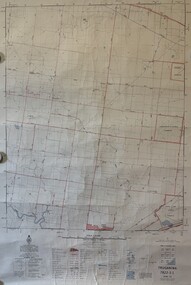
Map, Prepared by Commonwealth Section Imperial General Staff, Topographical map of Ringwood and surrounding areas dated 1-Aug-1935
... Topographical map of Ringwood and surrounding areas dated 1-Aug-1935....Topographical map of Ringwood and surrounding areas dated 1-Aug-1935. ...Two copies. Topographical map of Ringwood and surrounding areas dated 1-Aug-1935. ...Topographical map of Ringwood and surrounding areas dated 1-Aug-1935. Two copies.Ringwood Zone -
 Emerald Museum & Nobelius Heritage Park
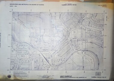
Map - Melbourne & Metropolitan Board of Works, Emerald Victoria, Topographical Map - Amendment 16.1.89, Melbourne and Metropolitan Board of Works, MMBW Topographical Map -Yarra 2500/28.01, 1989
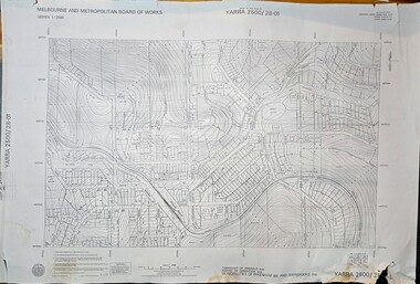
... Melbourne & Metropolitan Board of Works, Emerald Victoria, Topographical Map - Amendment 16.1.89...MMBW Topographical Map -Yarra 2500/28.01...Image of printed Melbourne & Metropolitan Board of Works topographical map - Emerald - Yarra 2500/28.01...Mitchell, Chief Surveyor, Engineering Branch: May 1984/Survey Co-ordination Act plan classification BB2/Revised and re-issued/Latest cadastral amendment 16.1.89/Scale 1:2500/Township of Emerald 5280, Parish of Gembrook 2645, Municipalities of Pakenham 262 And Sherbrooke259/YARRA 2500/28.01 Image of printed Melbourne & Metropolitan Board of Works topographical map - Emerald - Yarra 2500/28.01 MMBW Topographical Map -Yarra 2500/28.01 Map Melbourne & Metropolitan Board of Works, Emerald Victoria, Topographical Map - Amendment 16.1.89 Melbourne and Metropolitan Board of Works ...Topographical map of Emerald township from 1989, based on photography from 1981Image of printed Melbourne & Metropolitan Board of Works topographical map - Emerald - Yarra 2500/28.01non-fictionTopographical map of Emerald township from 1989, based on photography from 1981emerald -
 Emerald Museum & Nobelius Heritage Park
Map - Transparency edition - Melbourne & Metropolitan Board of Works, Emerald Victoria, Topographical Map - Amendment 16.1.89, Melbourne and Metropolitan Board of Works, MMBW Topographical Map -Yarra 2500/28.01, 1989
... Transparency edition - Melbourne & Metropolitan Board of Works, Emerald Victoria, Topographical Map - Amendment 16.1.89 ...MMBW Topographical Map -Yarra 2500/28.01...Image of printed Melbourne & Metropolitan Board of Works topographical map - Emerald - Yarra 2500/28.01...Mitchell, Chief Surveyor, Engineering Branch: May 1984/Survey Co-ordination Act plan classification BB2/Revised and re-issued/Latest cadastral amendment 16.1.89/Scale 1:2500/Township of Emerald 5280, Parish of Gembrook 2645, Municipalities of Pakenham 262 And Sherbrooke259/YARRA 2500/28.01 Image of printed Melbourne & Metropolitan Board of Works topographical map - Emerald - Yarra 2500/28.01 MMBW Topographical Map -Yarra 2500/28.01 Map Transparency edition - Melbourne & Metropolitan Board of Works, Emerald Victoria, Topographical Map - Amendment 16.1.89 Melbourne and Metropolitan Board of Works ...Topographical map of Emerald township from 1988Image of printed Melbourne & Metropolitan Board of Works topographical map - Emerald - Yarra 2500/28.01non-fictionTopographical map of Emerald township from 1988emerald