Showing 196 items matching "tourist sites"
-
 Ballarat Tramway Museum
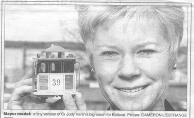
Newspaper, Herald Sun, "Tram plan for tourist sites", 6/08/1999 12:00:00 AM
... "Tram plan for tourist sites"..."Tram plan for tourist sites" Newspaper Herald Sun ...Newspaper clipping from the Herald Sun dated August 6, 1999, page 23, about the possibility of tourist trams returning to Ballarat. Mentions feasibility studies and quotes the Mayor, Judy Verlin about the plan and other studies such as the Maunsell study. Has photo of Judy Verlin holding a miniature cable tram and a photo of an ESCO tram in Sturt St. with Town Hall in background. Item written by Scott Thompson, Urban affairs reporter and picture by Cameron L'Estrange. ballarat revival, feasibility study, maunsell, sturt st. -
 Emerald Museum & Nobelius Heritage Park
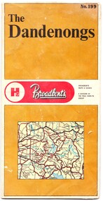
Map - Map of the Dandenongs, The Paul Hamlyn Group, c. 1970s
... ...tourist sites...This map of the Dandenongs c 1970s details tourist sites and walking tracks. ...The other side includes a street index, a list of tourist sites, a list of walking tracks, a map of Sherbrooke Forest, and a map of key approaches from the city to the Dandenongs....This map of the Dandenongs c 1970s details tourist sites and walking tracks. This map shows streets and walking tracks and tourist sites significant in the Dandenongs c. 1970s. ...George Broadbent was a Geelong-born cyclist record-holder, who produced from 1896 the most comprehensive and detailed maps of Victoria until his death in October 1947. His son had taken over map production in 1945. This map of the Dandenongs c 1970s details tourist sites and walking tracks. This map shows streets and walking tracks and tourist sites significant in the Dandenongs c. 1970s.Front of fold-out map titled 'The Dandenongs No. 199', produced by Broadbents. Folded out, one side is a street map of the Dandenongs. The other side includes a street index, a list of tourist sites, a list of walking tracks, a map of Sherbrooke Forest, and a map of key approaches from the city to the Dandenongs.On front: ' No. 199 / The / Dandenongs / Broadbents / Broadbents / Maps & Guides / A DIVISION OF / THE PAUL HAMLYN / GROUP'broadbents, dandenongs, 1970s, tourist sites, walking tracks -
 Marysville & District Historical Society
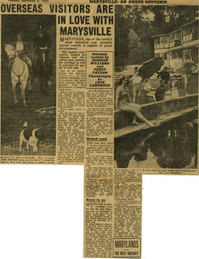
Newspaper (Item) - Newspaper article, The Argus Newspaper et al, Overseas visitors are in love with Marysville, 06-12-1955
... A digital copy of a newspaper article regarding the need for the government of the time to make improvements on roads and to infrastructure at tourist sites in the Marysville area....A digital copy of a newspaper article regarding the need for the government of the time to make improvements on roads and to infrastructure at tourist sites in the Marysville area....Marysville & District Historical Society 39 Darwin Street Marysville yarra-valley-and-the-dandenong-ranges A digital copy of a newspaper article regarding the need for the government of the time to make improvements on roads and to infrastructure at tourist sites in the Marysville area. A digital copy of a newspaper article regarding the need for the government of the time to make improvements on roads and to infrastructure at tourist sites in the Marysville area. marysville victoria newspaper article the argus jack lawrence gordon williams percy taylor marysville tourist and progress association lake mountain steavenson falls talbot drive keppel falls taggerty river Souvenir/ written by/ GORDON/ WILLIAMS/ and/ PERCY/ TAYLOR/ Photography/ by/ JACK/ LAWRENCE A digital copy of a newspaper article regarding the need for the government of the time to make improvements on roads and to infrastructure at tourist sites in the Marysville area. ...A digital copy of a newspaper article regarding the need for the government of the time to make improvements on roads and to infrastructure at tourist sites in the Marysville area.A digital copy of a newspaper article regarding the need for the government of the time to make improvements on roads and to infrastructure at tourist sites in the Marysville area.Souvenir/ written by/ GORDON/ WILLIAMS/ and/ PERCY/ TAYLOR/ Photography/ by/ JACK/ LAWRENCEmarysville, victoria, newspaper article, the argus, jack lawrence, gordon williams, percy taylor, marysville tourist and progress association, lake mountain, steavenson falls, talbot drive, keppel falls, taggerty river -
 Bendigo Military Museum
Poster - POSTCARDS, PHOTOGRAPHIC WW1, 1), .2), .3), .5), .8), .10) & .11) Brighton Palace Series, c.1916-1919
... Descriptions of tourist sites in Southern England, some with handwriting....Bendigo Military Museum 37 - 39 Pall Mall Bendigo goldfields Photographic postcards of Brighton & Folkestone, England sent home in WWI. photography-photographs military history Descriptions of tourist sites in Southern England, some with handwriting. ...Photographic postcards of Brighton & Folkestone, England sent home in WWI.Postcards B & W of Southern England.Descriptions of tourist sites in Southern England, some with handwriting.photography-photographs, military history -
 Bendigo Military Museum
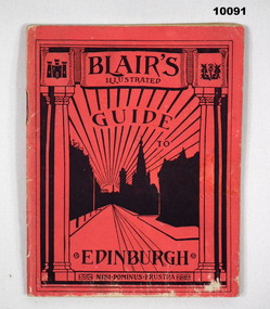
Booklet - GUIDE BOOK, GUIDE TO EDINBURGH, Unknown
... 64 page booklet with red cover and white pages containing contents include adverts, Pictures of tourist sites and brief description of individual tourist locations....Guide Book WW1 V E Giudice Collection of William (Bill) Thomason 64 page booklet with red cover and white pages containing contents include adverts, Pictures of tourist sites and brief description of individual tourist locations. ...Guide book for tourists in Edinburgh around time of WW1. Part of collection for Sgt "V.E. Giudice" No. 53730. refer Cat No. 10031P for details. Overall part of collection of William (Bill) Thomason, refer Cat No. 4136P.64 page booklet with red cover and white pages containing contents include adverts, Pictures of tourist sites and brief description of individual tourist locations.guide book, ww1, v e giudice, collection of william (bill) thomason -
 Phillip Island and District Historical Society Inc.
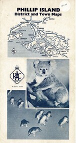
Map, Phillip Island District and Town Maps, 01/11/1967
... Map-Phillip Island and District Maps - Tourist guide to Phillip Island tourist sites. A3 page folded as a brochure. Blue print and photographs and advertisements....Historical Historical Society Map-Phillip Island and District Maps - Tourist guide to Phillip Island tourist sites. A3 page folded as a brochure. Blue print and photographs and advertisements. ...Map - PI District and Town Maps - Tourist brochure. Produced by the RSCV.HistoricalMap-Phillip Island and District Maps - Tourist guide to Phillip Island tourist sites. A3 page folded as a brochure. Blue print and photographs and advertisements.historical society -
 Tatura Irrigation & Wartime Camps Museum
Pamphlet, Get Hooked on Tatura
... Map of Tatura and list of industries and tourist sites...Map of Tatura and list of industries and tourist sites Get Hooked on Tatura Pamphlet ...Pamphlets to rpomote Tatura as a great place to visit with golf and bowls, tennis, horse racing and Waranga basin nearby2 pamphlets. Black and white sketches of cars in traffic jam promoting Tatura to visit and relax, on front, Tatura and relax - in red on back. Map of Tatura and list of industries and tourist sitesget hooked on tatura, promoting tatura, tatura, tourism, documents, pamphlets -
 Bendigo Military Museum
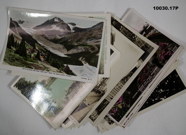
Postcard - PHOTOGRAPHIC POSTCARDS
... Series of 17 postcards taken in Canadian Rockies, Philadelphia, New York and England depicting various tourist sites. Six of the photos have writing on the back and the others are blank. ...Postcards WW2 Six photos (1 to 6) have writing on back and dates from “30.06.43 to 17.1.44” Series of 17 postcards taken in Canadian Rockies, Philadelphia, New York and England depicting various tourist sites. Six of the photos have writing on the back and the others are blank. ...Postcards from "David" sent from Canada and England while on Empire Air Training Scheme. One photo says he is with 2 ADS, Part of the collection of William (Bill) Thomason. Refer Cat 4136P.Series of 17 postcards taken in Canadian Rockies, Philadelphia, New York and England depicting various tourist sites. Six of the photos have writing on the back and the others are blank. Some postcards are in colour, some are black and white.Six photos (1 to 6) have writing on back and dates from “30.06.43 to 17.1.44”postcards, ww2, -
 Bendigo Military Museum
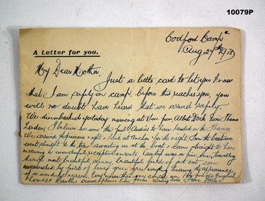
Photograph - LETTER & PHOTOGRAPHS, 24 Aug 1918
... All photos in B & W. and those of tourist sites had description at bottom. Pages stapled together....All photos in B & W. and those of tourist sites had description at bottom. Pages stapled together. ...Letter from camp after arrival in England. Part of the collection of V.E Giudice no. 53730. Refer Cat. No. 10038P, for service details. Part of overall collection of Bill Thomason. Refer Cat No. 4136P.Eight pages of letter on page 1 to his mother and following 7 pages of photographs of towns of Codford and Stockton, Stonehenge, Salisbury Cathedral and the Westbury White Horse. All photos in B & W. and those of tourist sites had description at bottom. Pages stapled together.Letter dated “Aug 24th, 1918 from Codford Camp”. Letter signed "Love Bill".letter, photographs, ww1, collection of william (bill) thomason, v e giudice -
 Bendigo Military Museum
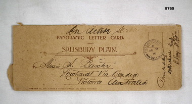
Card - PANORAMIC LETTER CARD, Hotocrom Co. Ltd, c.1916
... Inside 4 pages with 8 images of Army Barracks or tourist sites. On front is address sent to in Australia, Post Office stamp and signed off by Battalion. ...Inside 4 pages with 8 images of Army Barracks or tourist sites. On front is address sent to in Australia, Post Office stamp and signed off by Battalion. ...Sent home by Capt. Frederick Baxter MC. Part of the Baxter Collection. Refer Cat No.4219.Cream colour panoramic card Salisbury Plain. Inside 4 pages with 8 images of Army Barracks or tourist sites. On front is address sent to in Australia, Post Office stamp and signed off by Battalion. Photos are all labelled as per inscription and held together by one staple.Photo's labelled. Top written "On Active Service". 1. 40857 Bulford Camp. 2. 48060 Bulford Camp B Lines. 3. 36891 Bulford Camp near Salisbury. 4. 36868 Salisbury Plain, Tidworth Barracks. 5. 36889 Bulford The Bridge. 6. Amesbury, Queensbury Bridge. 7. 32482 Salisbury Stonehenge. 8. 32478 Salisbury Cathedral.letter card, baxter collection, ww1, baxter mc -
 Kiewa Valley Historical Society
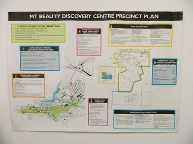
Poster - Mt Beauty Discovery Centre Precinct Plan
... The current (2015) Mt Beauty Tourist Centre site was to be upgraded into a 'Sports Tourism Cluster' with funding from the Government and the Alpine Shire with 'In Kind' assistance from Falls Creek Resort management Board, Parks Victoria and the Local Community & Tourism Industry. ...Kiewa Valley Historical Society Mount Beauty Information Centre 31 Bogong High Plains Rd Mt Beauty high-country The current (2015) Mt Beauty Tourist Centre site was to be upgraded into a 'Sports Tourism Cluster' with funding from the Government and the Alpine Shire with 'In Kind' assistance from Falls Creek Resort management Board, Parks Victoria and the Local Community & Tourism Industry. ...The current (2015) Mt Beauty Tourist Centre site was to be upgraded into a 'Sports Tourism Cluster' with funding from the Government and the Alpine Shire with 'In Kind' assistance from Falls Creek Resort management Board, Parks Victoria and the Local Community & Tourism Industry. This project didn't go ahead.The Mt Beauty town was handed over to the Alpine Shire in the 1960's after completion of the Kiewa Hydro Electric Scheme. Plans for up dating facilities are on-going but are rarely completed. This poster is an example of this.Very large laminated poster depicting 6 points for the Alpine Region Sports Tourism Cluster. Each point has a coloured border and background to black writing. There are 3 maps.mt beauty. tourism. discovery centre. sports cluster. -
 Federation University Historical Collection
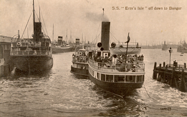
Postcard, S.S. "Erin's Isle" off down to Bangor, 1912
... During leave soldiers often visited tourists sites, family, or towns important to their ancestral heritage....During leave soldiers often visited tourists sites, family, or towns important to their ancestral heritage. chatham-holmes family collection bangor belfast mail ships steam ship six bob a day tourist S.S Erin's Isle off down to Bangor A view of paddle steamer with three moored mail steamers are visible to the left, and a pier and lamp on right. ...Erin's Isle was a paddle steamer built in 1912 by Messrs. A. & J. Inglis Pointhouse, Glasgow, for the Belfast and County Down Railway Company. It provided a regular service between Belfast Lough and Bangor, County Down in the summer season. In November 1915 it was requisitioned by the Admiralty, initially for transport purposes, and later as an auxiliary mine sweeper. Surviving World War One, this vessel as lost on 7 February 1919 after hitting a stray mine at the entrance of the Thames Estuary and immediately sank. There were 23 lives lost, and 28 survivors. Bangor is a city in Gwynedd Unitary Authority, north west Wales, and one of the smallest cities in Britain. This postcard was sent home to Australia by a six bob a day tourist, and member of the Australian AIF on active service. During leave soldiers often visited tourists sites, family, or towns important to their ancestral heritage.A view of paddle steamer with three moored mail steamers are visible to the left, and a pier and lamp on right. A ship can be seen iin distance on right. S.S Erin's Isle off down to Bangorchatham-holmes family collection, bangor, belfast, mail ships, steam ship, six bob a day tourist -
 Bendigo Historical Society Inc.
Document - DOCUMENTS RELATING TO: THE BENDIGO AND DISTRICT TOURIST ASSOCIATION, July 7th, 1970
... Tourist Association. Includes Minutes of five meetings of the Board (1970/1971); Notice of AGM 1969; Annual Report 1971; Articles of Association (as amended 14/9/1971); single page headed ''Development of Nell Gwynne and Victoria Hill Sites'' - extensive plans for a 'tourist site with museum, cemetery, chapple (sic), rotunda. ...Tourist Association. Includes Minutes of five meetings of the Board (1970/1971); Notice of AGM 1969; Annual Report 1971; Articles of Association (as amended 14/9/1971); single page headed ''Development of Nell Gwynne and Victoria Hill Sites'' - extensive plans for a 'tourist site with museum, cemetery, chapple (sic), rotunda. ...Various documents relating to the Bendigo and District Tourist Association. Includes Minutes of five meetings of the Board (1970/1971); Notice of AGM 1969; Annual Report 1971; Articles of Association (as amended 14/9/1971); single page headed ''Development of Nell Gwynne and Victoria Hill Sites'' - extensive plans for a 'tourist site with museum, cemetery, chapple (sic), rotunda. Theatre, façade of Charing Cross, a flying-fox from Nell Gwynne to Victoria Hill (no date); Mining Sub-Committee Report and Recommendation (Tourist Development Committee) 1967 re Resolution that ''Quartz Hill'' be developed as a mining tourist attraction (details provided ($75.000 est.); Draft Proposals for Brochure (authored by Miles Lewis, Carlton) - brochure to promote the idea of a museum and tourist development at the Nell Gwynne site; letter to Bendigo businesses re seeking funds for tourist development - Daryl McClure, Hon Sec June 1970.;bendigo, tourism, bendigo and district tourist association -
Dutch Australian Heritage Centre Victoria
tourists bicycle pennants, mid 20th century
... 4089.R1 - blue edged pennant, showing the tourist sites around a place called Epen in the southern part of the province of Limburg. ...The tradition of camping as the holiday of choice. 4089.R1 - blue edged pennant, showing the tourist sites around a place called Epen in the southern part of the province of Limburg. ...TourismHow people went on holiday. A memento of simple holidays. The tradition of camping as the holiday of choice.calico, triangular pennant. One edged in blue, the other in red.4089.R1 - blue edged pennant, showing the tourist sites around a place called Epen in the southern part of the province of Limburg. This is known because the name of the town is in large red letters. Three locations shown 1. Kamper Boerderij - A farm providing camping grounds. 2. Kasteel Beusdael - The Beusdael Castle 3. Wingbergermoelen - Wingberger Mill Also a little tent beneath the name of the town, with refers to the camping holiday. Also a maker's mark on the pennant, a small triangle with the letters L, A & B within it. 4089.R2 - red edged pennant, showing the area around Vaals in Limburg province, the name is in large red letters. The scene shows the meeting point between the Netherlands, Germany & Belgium - "Drie Landen Punt" (Three Country Meeting Point) Also shows the height of the viewing point (193m), as well showing other features including: - Hotel Bellevue - Uitzichttoren - viewing tower - Panorama Aken - Panorama of Aachen, Germany - Spoorbrug-Moresnet - Railwaybridge-Moresnet in Belgium. Small makers mark. Black triangle, possible the same as that shown in the other pennant, though obscured. -
 Bendigo Historical Society Inc.
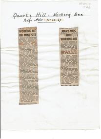
Newspaper - Quartz Hill Working Bee, 1967
... This is anticipated to 'clear the site of accumulated debris and clean out the two large adits driven into the hill and thus make the site a 'tourist visiting spot'. Cutting two, 'Many Miss Mine Working Bee' dated 11.12.67, describes the poor response to the working bee. ' Members of the Tourist Development Association and the Town Clerk, Mr. ...This is anticipated to 'clear the site of accumulated debris and clean out the two large adits driven into the hill and thus make the site a 'tourist visiting spot'. Cutting two, 'Many Miss Mine Working Bee' dated 11.12.67, describes the poor response to the working bee. ' Members of the Tourist Development Association and the Town Clerk, Mr. ...Quartz Hill is situated on the Sheephead line of reef and is situated just south of where the Red, White and Blue Consolidated Gold Mine operated. Two newspaper cuttings affixed to lemon backing sheet. Written on top in black pen: 'Quartz Hill Working Bee, Bdgo Adv. 11.12.67' Cutting one, 'Working Bee on Mine Site' with 7.12.67 written across the top, describes an appeal to get volunteers to clear the site of former mines on Quartz Hill. This is anticipated to 'clear the site of accumulated debris and clean out the two large adits driven into the hill and thus make the site a 'tourist visiting spot'. Cutting two, 'Many Miss Mine Working Bee' dated 11.12.67, describes the poor response to the working bee. ' Members of the Tourist Development Association and the Town Clerk, Mr. A.J. Watts, cleared 175 feet of the Northern tunnel and cut an entrance way and steps in the Southern tunnel of the New Blue Mine area in the first stage of the mining project. Mr. J. Stanistreet said last night he was most disappointed. He said: 'apparently we picked the wrong time of the year'.mining, sandhurst, new blue consolidated gold mine, red white and blue consolidated gold mine, quartz hill, sheepshead reef line, a.j. watts, j. stanistreet, bob long -
 Warrnambool and District Historical Society Inc.
Booklet, Fletcher Jones Handbook, 1951
... He opened a factory in Warrnambool, which, with it beautiful gardens, became a tourist attraction. The factory site was called Pleasant Hill. ...He opened a factory in Warrnambool, which, with it beautiful gardens, became a tourist attraction. The factory site was called Pleasant Hill. ...This booklet has been produced as a handbook for the employees of the Warrnambool-based clothing business of Fletcher Jones and Staff. Sir David Fletcher Jones (1895-1977) was born in Bendigo and served with the A.I.F. in World War One. He and an ex-war mate began trading in the Western District as itinerant hawkers of manchester and later Fletcher Jones continued on his own, gradually expanding the business until, in 1922, he opened a menswear and tailoring business in Warrnambool. By 1941 he was making nothing but men’s trousers, supplying retailers in over 100 outlets. In the late 1940s he turned his business into a Co-Operative and later expanded the business to include both men’s and women’s clothing. He opened a factory in Warrnambool, which, with it beautiful gardens, became a tourist attraction. The factory site was called Pleasant Hill. When he died in 1977 his business was one of the largest clothing manufacturers in Australia and possibly the world but, with the competition from imported clothing, the enterprise did not survive into the 21st century. It is presumed that Doug Ferguson was an employee of Fletcher Jones and that the gold label award was for his work or that of his department. This staff handbook for employees of the clothing business of Fletcher Jones & Staff is of major interest as this business, known nationally, was one of the most significant businesses ever to operate in Warrnambool. The handbook is of interest in itself as it has the Fletcher Jones logo, interesting material about the business philosophy of the business and Fletcher Jones himself, an autographed photograph of him and some significant photographs of the business, including indoor photographs of the factory.This is a soft cover booklet of 14 pages. It has a blue cover with the red and gold badge of Fletcher Jones on the front cover. The first page has handwritten material in black ink and a photograph of Fletcher Jones. There is also a gold label stuck on to the first page. There are many black and white photographs scattered throughout the text. ‘Presentation Copy. This copy is the property of Doug Ferguson, Pleasant Hill, With Best Wishes Fletcher Jones, Dec. 20 1951.’ Gold stamp: ‘Highest Award Cut, Make & Trim’ fletcher jones and staff, doug ferguson, history of warrnambool -
 Warrnambool and District Historical Society Inc.
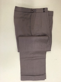
Pants, Fletcher Jones, Mid 20th century
... The Fletcher Jones Gardens at the Factory site are still maintained today and are a tourist attraction in the city. fletcher jones and staff coverdine fletcher jones trousers history of warrnambool david fletcher jones These are a pair of brown Fletcher Jones trousers made of Coverdine material (87.5% wool with nylon). ...These trousers have been made by Fletcher Jones and Staff. This business was established by David Fletcher Jones (1895-1977) in 1924 when he leased three shops in Liebig Street, Warrnambool. In 1928 he moved his business to the main retailing area near the Liebig Street/Koroit Street intersection. In 1931 a shop built to Fletcher Jones’ requirements was erected and by 1938 he had a staff of 40. By 1945 FJ trousers were sold in 123 stores in Victoria and in 1948 the Fletcher Jones factory was established in Flaxman Street Warrnambool, officially named Pleasant Hill. In 1951 the company became Fletcher Jones and Staff and by the mid 1970s the staff had 75% ownership. By this time FJ and Staff had become one of the largest clothing manufacturers in Australia with 55 shops and almost 3000 employees. The range of clothing was enlarged to include both men’s and women’s wear. In the 1980s, after the death of Fletcher Jones, the abolition of import tariffs and the availability of cheap imported clothing caused the Fletcher Jones Company to decline and to be sold to a Geelong company. By 2011 all Fletcher Jones shops had closed. These trousers are of great interest as they are a product of a Warrnambool business that was nationally and internationally known in the 20th century for its quality men’s wear, especially the Coverdine brand trousers. The Fletcher Jones business remains one of the most important businesses, (if not the most important), that ever existed in Warrnambool. It employed a great number of local people in the second half of the 20th century, and is remembered with great fondness by many people in the city and surrounds today. The Fletcher Jones Gardens at the Factory site are still maintained today and are a tourist attraction in the city. These are a pair of brown Fletcher Jones trousers made of Coverdine material (87.5% wool with nylon). There is some lining around the waist area and the legs are turned up at the end with some leather binding inside the bottom legs. The waist band is stiffened and is fastened with a metal clip and two buttons. The waist band has two adjustable areas using tabs and two buttons each side. The back pockets also have buttons.fletcher jones and staff, coverdine fletcher jones trousers, history of warrnambool, david fletcher jones -
 Warrnambool and District Historical Society Inc.
Document, Ella Webb, Warrnambool artist, Street Walks of Warrnambool, 2018
... This is a tourist guide to Warrnambool produced by a local artist, Ella Webb, in conjunction with the Warrnambool and District Historical Society. It includes a sketch map showing the location of some points of interest – buildings and sites of historical interest, places of interest that are no longer existing, some natural features (mainly along the coast) and some information about incidents and people in the past. ...Warrnambool and District Historical Society Inc. 2 Gilles Street (south of Merri St) Warrnambool great-ocean-road This is a tourist guide to Warrnambool produced by a local artist, Ella Webb, in conjunction with the Warrnambool and District Historical Society. It includes a sketch map showing the location of some points of interest – buildings and sites of historical interest, places of interest that are no longer existing, some natural features (mainly along the coast) and some information about incidents and people in the past. ...This is a tourist guide to Warrnambool produced by a local artist, Ella Webb, in conjunction with the Warrnambool and District Historical Society. It includes a sketch map showing the location of some points of interest – buildings and sites of historical interest, places of interest that are no longer existing, some natural features (mainly along the coast) and some information about incidents and people in the past. It is an attractive broadsheet that is a useful guide for visitors to Warrnambool. This sheet is of interest as a modern-day tourist map produced in an artistic fashion by a local Warrnambool artist.This is a single sheet of thick paper printed on both sides in green, brown, yellow and beige tonings. One side of the sheet has sketches of buildings and places of interest and printing and the other side has a sketch map of some of the main streets of Warrnambool and some of its attractions. -
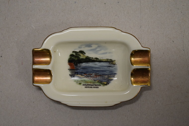 Warrnambool and District Historical Society Inc.
Ashtray, Alka Kunst, Warrnambool Hopkins River, c. 1960
... The boatshed is no longer there with sections of the building being relocated to a site in Henna Street and used for indoor recreational purposes. This ash tray is retained as an example of a local tourist souvenir sold to tourists in the 1960s. ...This item was bought as a souvenir of Warrnambool in the mid 20th century when cigarette smoking was more widespread and was socially acceptable. Tourism in Warrnambool has been an important industry for over 100 years. In the late 19th century Warrnambool was promoted as a spa resort with its mild climate, sea bathing and its hot and cold sea water baths complex. Today visitors come in winter for the May Racing Carnival and to see the Southern Right whales at Logans Beach and in summer they come for a beach holiday. The image on the dish shows the Warrnambool Hopkins River near its mouth. The boatshed is no longer there with sections of the building being relocated to a site in Henna Street and used for indoor recreational purposes.This ash tray is retained as an example of a local tourist souvenir sold to tourists in the 1960s. This is a small white china dish made in an oval shape and slightly raised from the surface on which it sits. The ends of the dish have four gold coloured indents for stubbing cigarettes. There is a gold rim around the edge of the dish and a coloured image of the old boat shed and jetty on the Hopkins River in Warrnambool. On the base of the dish is the logo of the maker and printed details.Warrnambool Hopkins River Alka Kunst Bavaria tourism in warrnambool, history of warrnambool -
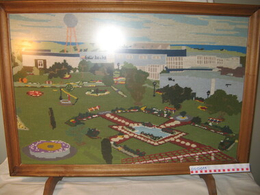 Warrnambool and District Historical Society Inc.
Textile - Fire screen, Tapestry, Post 1967
... In 1992 the Warrnambool City Council bought the factory and gardens with the site now a tourist attraction. Although the name is retained today for trading purposes the original Fletcher Jones company has been dissolved. ...In 1992 the Warrnambool City Council bought the factory and gardens with the site now a tourist attraction. Although the name is retained today for trading purposes the original Fletcher Jones company has been dissolved. ...David Fletcher Jones (1895-1977) was a travelling hawker who opened a business in Liebig Street, Warrnambool in 1924. In 1931 he opened The Man's Shop at the corner of Liebig Street and Koroit Street. He sold suits and overcoats tailored in the work rooms upstairs. In 1948 his factory known as Pleasant Hill was opened in Flaxman Street in Warrnambool, the site of an old quarry. In 1951 the company Fletcher Jones and Staff was formed with the staff owning 51% of the shares, By the 1970s Fletcher Jones and Staff had become one of the largest clothing companies in Australia with 55 shops and 3000 employees. In 1992 the Warrnambool City Council bought the factory and gardens with the site now a tourist attraction. Although the name is retained today for trading purposes the original Fletcher Jones company has been dissolved. The screen is a representation of the Fletcher Jones factory post 1967. It a wool tapestry by Martin Prider who was a painter and caretaker what the Fletcher Jones factory. He lived in one of the Fletcher Jones cottages on site. (Robin Boyd Age Small Homes Scheme, today Heritage listed.)This is an interesting memento of the Fletcher Jones company and the factory. It was done by a local resident and features the famous Fletcher Jones gardensTapestry fire screen in a rectangular light timber frame depicting the Fletcher Jones Factory Gardens. The screen has two timber feet, non relective glass and appears to be a wool tapestry. The image of the gardens is after 1967 as the silver ball is included and that was erected in 1967. Nilfletcher jones company and warrnambool factory, pleasant hill warrnambool, martin prider, fletcher jones, tapestry of fletcher jones factory -
 Kiewa Valley Historical Society
Papers - Falls Creek Tourist Area Management Committee, August 1984
... The Falls Creek Tourist Area Management Committee under the direction of the State Electric Commission of Victoria came into effect in 1959 and from then on building sites were leased and building and sewerage controls were applied. ...The Falls Creek Tourist Area Management Committee under the direction of the State Electric Commission of Victoria came into effect in 1959 and from then on building sites were leased and building and sewerage controls were applied. ...Falls Creek is a ski resort in the north east of Victoria on the Bogong High Plains. Members of business's (accommodation & restaurants) formed the Falls Creek Chamber of Commerce to promote tourism 'under' the Falls Creek Tourist Area Management Committee. The Falls Creek Tourist Area Management Committee under the direction of the State Electric Commission of Victoria came into effect in 1959 and from then on building sites were leased and building and sewerage controls were applied. In 1979 the Victorian State Government had established the Ski Industry of Victoria working party with a brief report on its operation. These papers give an insight into the business of the Falls Creek Chamber of Commerce in 1984 eg. car parking, noise, closure of the resort due to heavy snow falls, the media and general development of the resort. Local business people are named as attending the meeting indicating many non English surnames. 4 yellowed papers typed on both sides of the first 3 pages. irst paper has 6 items listed re Falls Creek Chamber of Commerce / Sub Committee on General Booking Conditions.Dated 15th August 1984 Next 3 papers dated 13th August 1984 Falls Creek Chamber of Commerce / Minutes of General Meetingfalls creek, ski resort, bogong high plains, falls creek chamber of commerce, snow, ski lodges, -
Kiewa Valley Historical Society
Papers - Mt Beauty Airport Development
... sites for an airstrip in Mt Beauty in 1965. The land was owned by the SEC and leased by Mr J. Sharp. It became available on the condition that the land would only be available to the Municipal shire. This land was officially opened as an Airport as an official tourist...sites for an airstrip in Mt Beauty in 1965. The land was owned by the SEC and leased by Mr J. Sharp. It became available on the condition that the land would only be available to the Municipal shire. This land was officially opened as an Airport as an official tourist ...The SECV began investigating four possible sites for an airstrip in Mt Beauty in 1965. The land was owned by the SEC and leased by Mr J. Sharp. It became available on the condition that the land would only be available to the Municipal shire. This land was officially opened as an Airport as an official tourist activity in 1977. It continues to be available to tourists, fire fighters, the air ambulance and the local gliding club.The opening of Mt Beauty Airport has enhanced Mt Beauty township by enabling fire fighters to access the surrounding bush during bush fires, by enabling Ambulance helicopters to rush emergency patients to city hospital, by giving tourists the opportunity to fly in and to give the local Gliding Club the opportunity to store and fly their gliders. 1. Set of papers titled 'History Mt Beauty Airport Development' held together by large steel clip by Alex McCullough. 2. Set of papers titled 'Department of Transport' and 'Alpine Shire' both held together by one staple. 3.Mt Beauty Township Survey Plan of Airstrip 1975 4. Large folder titled Mr J. R. Sharp 1975 - Mt Beauty Airfieldmt beauty airport history, alex mccullough, transport, tourism -
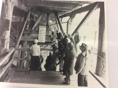 Port of Echuca
3 black and white photographs, 20/09/1984
... tourists. The sign shows distances from Echuca to significant sites on the Murray River in miles, as that was the way distance was calculated in the 1870's. ...tourists. The sign shows distances from Echuca to significant sites on the Murray River in miles, as that was the way distance was calculated in the 1870's. ...This photograph shows the wharf in the 1980's. It is the early days of tourism, and shows Helen Coulson, dressed in period costume guiding the tourists. The sign shows distances from Echuca to significant sites on the Murray River in miles, as that was the way distance was calculated in the 1870's. The sign is no longer there.This photograph shows Helen Coulson as a tour guide. Helen was the first Manager of the Port of Echuca from the mid 1970's. The tourism industry was still in it's infancy and Helen was a strong supporter of the Port. The photograph also shows the structure of the wharf as the photograph is taken on the lower level.3 black and white photographs of tourists under the wharf with Helen Coulson, dressed in period costume, as a tour guide. The structure of the wharf can be clearly seen. Also a sign with towns showing their distance from Echuca, in miles, can clearly be seen. The three photographs are identical. There are no inscriptions or markings.helen coulson, echuca wharf., tourism, murray river, rosel, mike -
Port of Echuca
Audio - Oral History - Geoff Evans, Oral History of Geoffrey Thomas Evans of Echuca b1924 d 2007
... The mill employed 18 workers and operated until the 1980s, only briefly was it in the hands of other owners before the construction on part of the site of a tourist-oriented building known as the Red Gum Works which eventually made way for the Port of Echuca Discovery Centre in 2014....The mill employed 18 workers and operated until the 1980s, only briefly was it in the hands of other owners before the construction on part of the site of a tourist-oriented building known as the Red Gum Works which eventually made way for the Port of Echuca Discovery Centre in 2014. ...Geoff Evans was the third generation to run Evans Brothers Sawmills that operated from the northern end of the Echuca Wharf from 1923 to 1983. His grandfather Richard James Evans orig. of England, settled in Victoria at a young age. He first worked as a butcher and later cut firewood in the Heathcote and Bacchus Marsh area. ‘R.J.’, as he was known established a sawmill at Barmah in the 1890s, before relocating to this site in 1923. It became known officially as the Evans Bros. Echuca Red Gum Sawmill. This site proved more economical due to its position at the railhead. Paddlesteamers towed barges carrying the logs from the surrounding forests to this mill. The Steamers that were owned by the Evans family were the Edwards (built 1875) and the Melbourne (built 1912). The Edwards was the main towing vessel. Outrigger barges at this mill were the Impulse (1885), Alison (1907), Clyde (once a paddlesteamer, built in 1884). Insider barges at the mill were old wool barges with iron topsides, the J.L.Roberts (1894), ADA (1899) and the Whaler which was of wooden construction. The Evans Mill cut both red gum and Murray pine. There was a main mill for the red gum and a second one for the pine on this site. Two new Marshall steam engines had been purchased by the family, one was used in the P.S. Edwards and the other for the Barmah mill and later this site. The Evans Bros. Mill was very much a family concern with it being owned and operated firstly by R.J., then his son Frederick. R. Evans and later grandson Geoff Evans. The mill employed 18 workers and operated until the 1980s, only briefly was it in the hands of other owners before the construction on part of the site of a tourist-oriented building known as the Red Gum Works which eventually made way for the Port of Echuca Discovery Centre in 2014.Knowledge of the redgum timber milling industry and associated mechanisms such as log slips is scant with little photographic representations to be found. The industry created alongside the Murray River in various places was very unique given the nature of red gum not floating and ingenuity and making use of local resources was required. Geoff Evans had firsthand knowledge of much of this process and how the Echuca Wharf area used to be in past decades. Geoff was also a popular musician and mayor of Echuca so had much knowledge of the local history and community.Digital recording of oral history interview with Geoff Evans of Evans Brothers Sawmill Echuca. evans bros, evans bros saw mills, evans' sawmill, geoff evans, log slip, log skid, p.s. edwards, p.s. melbourne, impulse barge, allison barge, clyde barge, j.l. roberts barge, ada barge, whaler barge, murray pine, redgum, marshall engines, r.j evans, f.j. evans, discovery centre, p.s. marion -
 Orbost & District Historical Society
newspaper clippings, April, May 1987
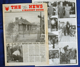
... site. It was restored and brought to life as a Tourist Information Centre in 1987....site. It was restored and brought to life as a Tourist Information Centre in 1987. ...The Slab Hut (Orbost Visitor Information Centre) was opened on March 28, 1987. It was officially opened by Dr D. Caughey, the governor of Victoria. The Orbost Visitor Information Centre is situated in Forest Park on Nicholson Street. The centre is housed in the historic Slab Hut. The hut was an original family dwelling built in 1872, on a site approximately three kilometres upstream from the junction of the Buchan and Snowy Rivers. The Hut was removed from its original site around 1970, and stored until 1984 when the Shire Council approved the current site. It was restored and brought to life as a Tourist Information Centre in 1987.The Slab Hut is an icon of Orbost. These newspaper articles are contemporary records of the opening of this building.A selection of articles from The News and the Snowy River Mail. All relate to the opening of the Slab Hut, the Orbost Visitor Information Centre. They are photographs, information and the history of the Slab Hut.slab-hut-orbost newspaper-snowy-river-mail -
 Orbost & District Historical Society
two books, The Bronze Swagman Book Of Bush Verse, 1979 ; 1980
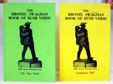
... The Winton Tourist Promotion Association (W.T.P.A.) was formed in October 1967, and because of the connection to Banjo Paterson and Waltzing Matilda, it wanted to encourage the writing of traditional Australian verse that was made so popular by A.B. "Banjo" Paterson, Henry Lawson etc. which is so much a part of our Australian heritage. The Bronze Swagman award was the result. (ref Bronze Swagman web-site...Orbost & District Historical Society Ruskin Street Orbost gippsland The Winton Tourist Promotion Association (W.T.P.A.) was formed in October 1967, and because of the connection to Banjo Paterson and Waltzing Matilda, it wanted to encourage the writing of traditional Australian verse that was made so popular by A.B. "Banjo" Paterson, Henry Lawson etc. which is so much a part of our Australian heritage. The Bronze Swagman award was the result. (ref Bronze Swagman web-site ...The Winton Tourist Promotion Association (W.T.P.A.) was formed in October 1967, and because of the connection to Banjo Paterson and Waltzing Matilda, it wanted to encourage the writing of traditional Australian verse that was made so popular by A.B. "Banjo" Paterson, Henry Lawson etc. which is so much a part of our Australian heritage. The Bronze Swagman award was the result. (ref Bronze Swagman web-site). For 40 years the group has been publishing the verse of winning entries.Two paperback books of verse. 1832.1 has a green cover. As well as the book title it has 1979 Award Winning Poem The New Farm. 1832.2 has a yellow cover. It has 1980 Award Winning Poem Condamine Bell. Both have black print titles with a silhouette of the swagman trophy awarded to the annual winner of The Swagman Award for bush poetry.bronze-swagman literature australian-bush-poetry winton -
 Orbost & District Historical Society
map/brochure, Discovering Marlo & The Snowy River Estuary, December 1988
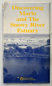
... There is a locality map for access to Corringle beach and the brochure Includes a key to fishing sites and various tourist locations. On the back of the brochure are notes on fishing, wildlife and a boating guide, ...tourist information in Orbost. This item is a useful research tool. map brochure snowy-river marlo A folded map/brochure titled "DISCOVERING MARLO & THE SNOWY RIVER ESTUARY". On the front is a photograph of Marlo and the title in yellow print. There is a locality map for access to Corringle beach and the brochure Includes a key to fishing sites ...In 1983 the Department of Conservation, Forests and Lands replaced the Department of Crown Lands and Survey, the Department of State Forests and the Ministry for Conservation. This brochure/map was used as tourist information in Orbost.This item is a useful research tool.A folded map/brochure titled "DISCOVERING MARLO & THE SNOWY RIVER ESTUARY". On the front is a photograph of Marlo and the title in yellow print. There is a locality map for access to Corringle beach and the brochure Includes a key to fishing sites and various tourist locations. On the back of the brochure are notes on fishing, wildlife and a boating guide, map brochure snowy-river marlo -
 Eltham District Historical Society Inc
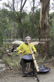
Photograph - Digital Photograph, Marguerite Marshall, Jesse Tree playing the Didgeridoo and Swiss Hang Drum at St Andrews Market, 29 March 2008
... site to buy or sell. On February 23, 1973, about 20 stallholders arrived with tables. They traded ‘second-hand clothes, vegetables, meat, cheese, eggs, chickens, goats, scones, tea, garden pots and peacock feathers’. Now around 2000 people visit each Saturday. People usually linger until dusk. The market – with around 150 stalls of wares from a wide variety of cultures – stands alongside Montsalvat as the most popular tourist...site to buy or sell. On February 23, 1973, about 20 stallholders arrived with tables. They traded ‘second-hand clothes, vegetables, meat, cheese, eggs, chickens, goats, scones, tea, garden pots and peacock feathers’. Now around 2000 people visit each Saturday. People usually linger until dusk. The market – with around 150 stalls of wares from a wide variety of cultures – stands alongside Montsalvat as the most popular tourist ...Published: Nillumbik Now and Then / Marguerite Marshall 2008; photographs Alan King with Marguerite Marshall.; p175 It’s Saturday morning and thousands of people are visiting St Andrews Market at the corner of Heidelberg-Kinglake Road and Proctor Street. It’s hard to find a park. Cars are banked up along the narrow road and crammed in a nearby parking area. Yet, at the market, people look relaxed and happy amongst the yellow box gums on the site where the Wurundjeri people used to gather. Stone artefacts unearthed there by Koorie researcher, Isabel Ellender, indicate the site was once a Wurundjeri meeting place, according to Aboriginal Affairs Victoria. Acoustic sounds mingle with quiet conversations. A guitarist blows a mouth organ while his bare toes tickle chimes. A tiny busker, perhaps five years old, plays a violin while sounds of a harp emerge from the hall. One stallholder, selling delicious-looking pastries, chats to another in Spanish, then to me in broad Australian. ‘I was born in Fitzroy but my mother came from Mexico and my dad from Serbia,’ she smiles. A New Zealander fell in love with Mongolia and now imports their hand-made embroidered clothes and Yurts (tents) and runs adventure tours. A young woman visited Morocco and when friends admired the shoes she bought, she decided to import them and sell them at the market. Oxfam sells Fair Trade toys and clothes and displays a petition to Make Poverty History. Other stalls sell Himalayan salt, jewellery made from seeds from northern Australia, glass paper-weights from China as well as locally grown vegetables, flowers and organic freshly baked bread. A woman sits in a state of bliss under the hands of a masseur. Another offers Reiki or spiritual healing. A juggler tosses devil sticks – ‘not really about the devil,’ he smiles. This skill was practised thousands of years ago in Egypt and South America he says. At the Chai Tent people lounge on cushions in leisurely conversation. The idea for the market was first mooted among friends over a meal at the home of famous jazz and gospel singer Judy Jacques.2 Jacques remembers a discussion with several local artists including Marlene Pugh, Eric Beach, Les Kossatz, Ray Newell and Peter Wallace. ‘We decided we wanted a meeting place, where all the different factions of locals could meet on common ground, sell their goodies and get to know one another,’ Jacques recalls. They chose the site opposite another meeting place, St Andrews Pub. A week later Jacques rode her horse around the district and encouraged her neighbours to come along to the site to buy or sell. On February 23, 1973, about 20 stallholders arrived with tables. They traded ‘second-hand clothes, vegetables, meat, cheese, eggs, chickens, goats, scones, tea, garden pots and peacock feathers’. Now around 2000 people visit each Saturday. People usually linger until dusk. The market – with around 150 stalls of wares from a wide variety of cultures – stands alongside Montsalvat as the most popular tourist attraction in Nillumbik. By the 1990s St Andrews Market was in danger of being loved to death, as the site was becoming seriously degraded. The market was spreading in all directions and the degradation with it. A local council arborist’s report in 1994 noted exposed tree roots from erosion and compaction. The Department of Sustainability and Environment threatened to close the market if the degradation was not rectified. After many months of research, discussions and lobbying by a few residents, the council formed a Committee of Management, with an Advisory Committee, and introduced an Environment Levy. The State Government, the council and the market, funded terracing of the site to stop erosion, and retain moisture and nutrients. Vehicles were excluded from some sensitive areas and other crucial zones reserved for re-vegetation. Volunteers planted more than 3000 locally grown indigenous species. The old Yellow Box trees fully recovered and are expected to give shade for many years to come.This collection of almost 130 photos about places and people within the Shire of Nillumbik, an urban and rural municipality in Melbourne's north, contributes to an understanding of the history of the Shire. Published in 2008 immediately prior to the Black Saturday bushfires of February 7, 2009, it documents sites that were impacted, and in some cases destroyed by the fires. It includes photographs taken especially for the publication, creating a unique time capsule representing the Shire in the early 21st century. It remains the most recent comprehenesive publication devoted to the Shire's history connecting local residents to the past. nillumbik now and then (marshall-king) collection, didgeridoo, jesse tree, st andrews market, swiss hang drum -
Glen Eira Historical Society
Article - Grand Union Tramway Junction, Balaclava Road and Hawthorn Road
... Prahran and Malvern Tramways Trust Caulfield Leader Bayside Weekly Tooke Craig Tourist attractions Grand Union Tramways Junction Caulfield Junction Cable Car Tramways Tram shelters Building Sheds Alma Road Orrong Road Caulfield Electric Line Balaclava Junction Elsternwick Railway Station Caulfield station Caulfield Station loop Tram services Transport establishments Thoroughfares Buildings Structures Establishments Parts of buildings or structures Documents Commercial industry Sites Historic sites Melbourne Bayside Weekly Article Grand Union Tramway Junction, Balaclava Road and Hawthorn Road ...This file contains three items. 1. A three-page Caulfield Conservation Study of the Balaclava Road/Hawthorn Road Tramway Crossing, undertake by Andrew Ward and dated September 1994. Study includes a brief history of the junction and a statement of significance. Study also includes Four black and white photographs of the junction and of architectural details of the tram tracks. 2. A letter from the Conservation Manager of the National Trust of Australia (Victoria) to the manager of the Planning Section for the City of Glen Eira, dated 15/06/2001 and attached to a six-page Classification Report. The letter informs of the Classification of the Grand Union Junction at the intersection of Balaclava and Hawthorn Road by the national trust, signed by Conservation Manager Ian Pausacker. Classification Report includes details such as the date of construction, a statement of significance, history of the junction, physical description of the junction and the condition of the junction at the time of writing. Report also includes a map of the Melbourne Tram Network drafted by Keith Kings and dated 01/005/1956, with illustration of the layout of fifteen tram depots, and updated aerial illustration of the Grand Union Junction, and a further map of Melbourne Tramways developed by North Melbourne Electric Tramways and Lighting Co. and Prahran and Malvern Tramways Trust, drafted by Keith Kings and dated January 1914 with illustrations of three tram depots. 3. Two articles from the Caulfield Leader written by Aaron Langmaid and dated 13/02/2007 and the Melbourne Bayside Weekly dated 21/02/2007 written by Joanne Sim, both concerning the Grand Union Junction. The article from the Caulfield Leader includes a picture of Executive Officer of the council of Tramway Museum of Australia Craig Tooke in front of the intersection. The article from the Bayside Weekly includes a picture of a tram passing through the junction and a brief history of the junction and tram network in Caulfield. The article also refers to twp local tram shelters at the intersection of Dandenong Road and Alma Road and also Orrong Road and Balaclava Road.caulfield, caulfield conservation, study, balaclava road, hawthorn road, grand union junction, ward andrew, tramway crossings, transport, acland street, caulfield racecourse, tram tracks, race events, event, tram routes, thorough fares, melbourne and metropolitan tramways board, prahran and malvern tramway trust, prahran and malvern district tramways, caulfield electric tramways, caulfield city council, architectural detail, city of glen eira, balaclava road and hawthorn road intersection, balaclava road and hawthorn road junction, dandenong road, glenhuntly road, four-way tram junctions, access covers darling road, cast metal access covers, hadfields patent, caulfield park, tram systems, tram networks, heritage, tramway heritage, kings keith, tram depots, glenhuntly depot, maps, glen eira, melbourne electric tramways, north melbourne electric tramways and lighting co., prahran and malvern tramways trust, caulfield leader, bayside weekly, tooke craig, tourist attractions, grand union tramways junction, caulfield junction, cable car tramways, tram shelters, building, sheds, alma road, orrong road, caulfield electric line, balaclava junction, elsternwick railway station, caulfield station, caulfield station loop, tram services, transport establishments, thoroughfares, buildings, structures, establishments, parts of buildings or structures, documents, commercial industry, sites, historic sites, melbourne bayside weekly -
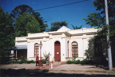 The Beechworth Burke Museum
Photograph, c1999-2000
... The Burke Museum is Australia’s oldest regional museum and part of Beechworth's Historic and Cultural Precinct, one of Australia’s best preserved historic-town sites and a popular tourist destination. Once the government centre for a vast gold fields region, this collection of nationally significant buildings tells the story of how Australia grew and prospered. ...This photograph taken c1999/2000, depicts the Burke Museum’s granite façade and vestibule entrance. The museum's large red door is closed and there is a white sign is attached to the door. The museum site dates to the 1857 founding of the Beechworth Public Library and Athenaeum by a newly formed Young Men's Association (YMA). In 1863 the museum was dedicated as a memorial to former Beechworth police superintendent (1854-1858) and explorer Robert O’Hara Burke, following Burke’s death from malnutrition on the Burke and Wills expedition in 1861. Funded by the Victorian Government and the Royal Society of Victoria, the officially titled 'Victorian Exploring Expedition' was tasked with being the first European party to traverse Australia from south to north. The Burke Museum holds objects from the famous expedition and explores the multi-layered history of Beechworth and surrounds from the gold rush era to the present.This photograph is historically significant for its depiction of the Burke Museum c1999/2000. The Burke Museum is Australia’s oldest regional museum and part of Beechworth's Historic and Cultural Precinct, one of Australia’s best preserved historic-town sites and a popular tourist destination. Once the government centre for a vast gold fields region, this collection of nationally significant buildings tells the story of how Australia grew and prospered. The frequent use of honey-coloured local granite as a building material, which can be seen in the museum's fabric, gives Beechworth’s historic buildings a distinct and cohesive local character. This photograph captures this distinctive character and may be compared and studied alongside other images of historic buildings in the Burke Museum Photographic Collection.Rectangular colour photograph printed on photographic paper.Reverse: 7031 / Label: Burke Museum / 1999/2000 /burke museum, indigo shire, beechworth athanaeum, beechworth library, beechworth historic building, historic precinct, burke museum exhibition, from the liedertafel to the skating rink, honey-coloured local granite, robert o'hara burke, victorian gold fields, historic towns in victoria, colonial australia, liedertafel, colonial entertainments, beechworth brass band, historic victorian architecture, australia's oldest regional museum, burke and wills expedition, first europeans to cross australia, yound mens associations, beechworth tourism, things to see in beechworth, beechworth historic trail, young men's associations