Showing 81 items matching "tourist track"
-
 Cockatoo History & Heritage Group
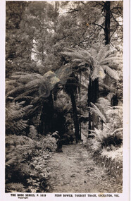
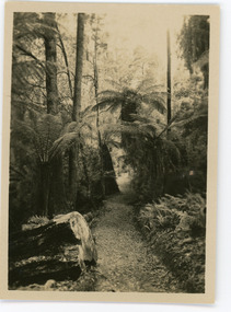
Postcard, Rose Stereograph Co, Fern Bower, Tourist Track, Cockatoo, VIC
... Fern Bower, Tourist Track, Cockatoo, VIC......Tourist Track...Cockatoo's Tourist Track featured in many postcards that were produced. ...Cockatoo Creek Tourist Track Rose Series Postcard Cockatoo Victoria Original Postcard - The Rose Series P 1619 Fern Bower, Tourist Track, Cockatoo, VIC Postcard Rose Stereograph Co. ...Cockatoo's Tourist Track featured in many postcards that were produced. It was an important attraction for the many holiday makers that came to Cockatoo in the early part of last century.The Tourist Track extended along the Cockatoo Creek, crossing the creek in various parts. It seemingly followed the creek until it ended in the vicinity of Mountain Rd and started near the swimming pool.Original Postcard - The Rose Series P 1619 cockatoo creek, tourist track, rose series postcard, cockatoo victoria -
 Mt Dandenong & District Historical Society Inc.
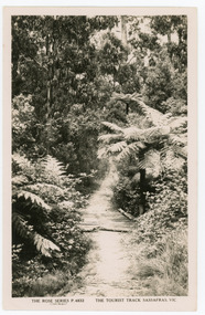
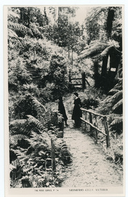
Photograph, The Tourist Track, Sassafras.Vic, c1920
... The Tourist Track, Sassafras.Vic...The tourist track running alongside the creek from Sassafras Mechanics’ Hall to Emerald. ...Black and white Rose Series postcard P. 4832 showing a section of the Tourist Track in Sassafras surrounded by tree ferns and bush....The Tourist Track, Sassafras.Vic Photograph Photograph ...The tourist track running alongside the creek from Sassafras Mechanics’ Hall to Emerald. In the early 1900s the track started at Rostrevor Guest House.Black and white Rose Series postcard P. 4832 showing a section of the Tourist Track in Sassafras surrounded by tree ferns and bush.On Reverse POST CARD A Real Photograph. Produced in Australia.sassafras, rose series, postcard, track -
 Mt Dandenong & District Historical Society Inc.
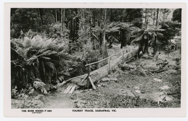
Photograph, Tourist Track, Sassafras. Vic, c1920
... Tourist Track, Sassafras. Vic....The tourist track running alongside the creek from Sassafras Mechanics’ Hall to Emerald. ...Shows a log bridge along a tree fern lined section of the Tourist Track....Shows a log bridge along a tree fern lined section of the Tourist Track. Tourist Track, Sassafras. Vic. Photograph Photograph ...The tourist track running alongside the creek from Sassafras Mechanics’ Hall to Emerald. In the early 1900s the track started at Rostrevor Guest House.Black & White postcard P1501 from the Rose Series. Shows a log bridge along a tree fern lined section of the Tourist Track.On reverse - POST CARD A Real Photograph. Produced in Australia.rose series, sassafras, track, postcard, mechanics' hall -
 Mt Dandenong & District Historical Society Inc.
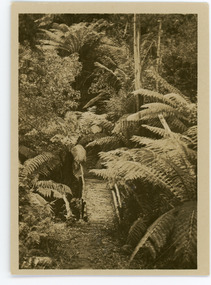
Photograph, Tourist Track, Sassafras, c1913
... Tourist Track, Sassafras...On reverse - Tourist Track, Sassafras...Tourist Track, Sassafras Photograph ...This set of 8 photographs was produced by the Rose Stenograph Co. c1913 to be included in photograph albums. They show tourist scenes of Sassafras and surrounds. The photographs were donated by a family in Western Australia whose parents lived in Sassafras c1918.Small b & w photograph from a series of 8 showing scenes from Sassafras produced by the Rose Stenograph Co. c1913.On reverse - Tourist Track, Sassafrassassafras, bridge, footbridge, rose series -
 Mt Dandenong & District Historical Society Inc.
Photograph, Tourist Track, Sassafras, c1913
... Tourist Track, Sassafras...On reverse - Tourist Track, Sassafras...Tourist Track, Sassafras Photograph ...This set of 8 photographs was produced by the Rose Stenograph Co. c1913 to be included in photograph albums. The show tourist scenes of Sassafras and surrounds. The photographs were donated by a family in Western Australia whose parents lived in Sassafras c1918.Small b & w photograph from a series of 8 showing scenes from Sassafras produced by the Rose Stenograph Co. c1913.On reverse - Tourist Track, Sassafrassassafras -
 Mt Dandenong & District Historical Society Inc.
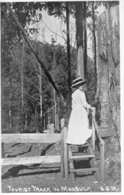
Photograph, Tourist Track To Monbulk, c1917
... Tourist Track To Monbulk...Tourist Track To Monbulk G.G.M....Tourist Track To Monbulk Photograph ...Miss Gwen Roberts, daughter of John and Roberta Roberts of Sunnyside, South Sassafras (now Kallista), climbing a style on the Monbulk Track.Tourist Track To Monbulk G.G.M.gwen roberts, monbulk track -
 Mt Dandenong & District Historical Society Inc.
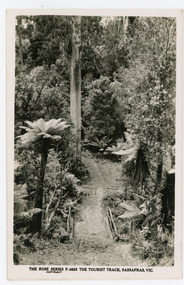
Photograph, The Tourist Track, Sassafras. Vic, c1920
... The Tourist Track, Sassafras. Vic...The tourist track running alongside the creek from Sassafras Mechanics’ Hall to Emerald. ...The Tourist Track, Sassafras. Vic Photograph Photograph ...The tourist track running alongside the creek from Sassafras Mechanics’ Hall to Emerald. In the early 1900s the track started at Rostrevor Guest House.Black and white photograph. Rose Series P. 4825 postcard showing a footbridge along a Tourist rack surrounded by bush and tree ferns.rose series, rostrevor, mechanics' hall, sassafras, track -
 Mt Dandenong & District Historical Society Inc.
Photograph, Sassafras Gully, Victoria, c1920
... The tourist track running alongside the creek from Sassafras Mechanics’ Hall to Emerald. ...Farndons Community Hall 42 Falls Road Mt Dandenong yarra-valley-and-the-dandenong-ranges The tourist track running alongside the creek from Sassafras Mechanics’ Hall to Emerald. ...The tourist track running alongside the creek from Sassafras Mechanics’ Hall to Emerald. In the early 1900s the track started at Rostrevor Guest House.Black and white copy of Rose Series Post card P. 74 showing two young women standing on a footbridge at Sassafras Gully. A set of steep steps can be seen above them.rose series, track, footbridge, bridge, sassafras -
 Bendigo Historical Society Inc.
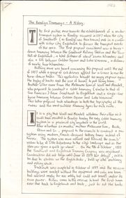
Document - ''THE BENDIGO TRAMWAYS: A HISTORY''
... Talking Tourist Tram. Tramsways Track Diagram. Battery Trams...Track Diagram as at closure of system, April 1972''. Early moves to have tramway system in 1880s; battery trams operation; steam tram motors; Bendigo Tramway Company; Electric Supply Company; Route maps (''in the appendices at the end of this report'' ???); State Electricity Commission of Victoria; list of the major purchases made by the SEC from the MMB to add to the Bendigo fleet (1930 -1960) closure of tramways; Bendigo 'talking' tourist tram (Dec. 1972); Writer's notes - acknowledgement...Bendigo Tramways Electric Supply Company Talking Tourist Tram. Tramsways Track Diagram. Battery Trams Ellsen and Co. ...''The Bendigo Tramways - A History'' (author, not named, but last page indicates that writer was 17 years of age). Eight handwritten pages; 4 pages of photo reproductions; loose sheet - broad description of 'Bendigo''; loose sheet showing ''S.E.C. Bendigo Tramways Track Diagram as at closure of system, April 1972''. Early moves to have tramway system in 1880s; battery trams operation; steam tram motors; Bendigo Tramway Company; Electric Supply Company; Route maps (''in the appendices at the end of this report'' ???); State Electricity Commission of Victoria; list of the major purchases made by the SEC from the MMB to add to the Bendigo fleet (1930 -1960) closure of tramways; Bendigo 'talking' tourist tram (Dec. 1972); Writer's notes - acknowledgementtramways, history, bendigotramway history., bendigo tramways, electric supply company, talking tourist tram. tramsways track diagram. battery trams, ellsen and co., the sandhurst and eaglehawke tramways company. mollison street. arnold street. -
 Mt Dandenong & District Historical Society Inc.
Photograph, Beauty Spots in Australia. Sassafras, c1913
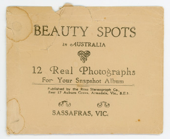
... Photograph 32f - THE ROSE SERIES P. 1501 TOURIST TRACK, SASSAFRAS, VIC. Photograph 32g - THE ROSE SERIES P. 4244 TOURIST TRACK, SOUTH SASSAFRAS, VIC. ...Photograph 32f - THE ROSE SERIES P. 1501 TOURIST TRACK, SASSAFRAS, VIC. Photograph 32g - THE ROSE SERIES P. 4244 TOURIST TRACK, SOUTH SASSAFRAS, VIC. ...This set of small photographs was produced by the Rose Stenograph Co. c1913 to be included in photograph albums. The area known as South Sassafras, was opened up for settlement in 1893 and the name was changed to Kallista in 1925.A small, paper envelope containing 12 photographs of Sassafras that are reproductions of Rose Series postcards. There are 10 different photographs, 32a and 32c have doubles.Envelope : BEAUTY SPOTS in AUSTRALIA 12 Real Photographs For Your Snapshot Album Published by the Rose Stenograph Co. Rear 17 Auburn Grove, Armadale, Vic 3.E.3 SASSAFRAS, VICTORIA Photograph 32a - THE ROSE SERIES P. 905 CLEMATIS AVENUE, SHERBROOKE, VIC. Photograph 32b - THE ROSE SERIES P. 1603 THE CASCADES, SASSAFRAS, VIC. Photograph 32c - THE ROSE SERIES P. 204 PANORAMA AT SASSAFRAS, VIC. Photograph 32d - THE ROSE SERIES P. 4046 MAIN ROAD, SASSAFRAS, VIC. Photograph 32e - THE ROSE SERIES P. 1502 SASSAFRAS CREEK, SASSAFRAS, VIC. Photograph 32f - THE ROSE SERIES P. 1501 TOURIST TRACK, SASSAFRAS, VIC. Photograph 32g - THE ROSE SERIES P. 4244 TOURIST TRACK, SOUTH SASSAFRAS, VIC. Photograph 32h - THE ROSE SERIES P. 2725 CLEMATIS AVENUE, SHERBROOKE, VIC. Photograph 32i - MAIN ROAD, SASSAFRAS, VIC. Photograph 32j - THE OLINDA - SASSAFRAS ROAD, VIC. rose series, rose series, sassafras, sherbrooke, sassafras creek -
 Halls Gap & Grampians Historical Society
Flyer - B/W, C 1924-25
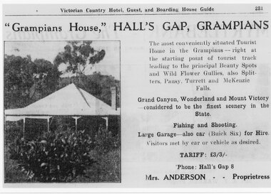
... Tariff L 3/3 Mrs Anderson was proprietress "Grampians House," Hall's Gap, Grampians, The most conveniently situated Tourist Home in the Grampians - right at the starting point of tourist track leading to the principal Beauty Spots and Wild Flower Gullies, also Splitters, Pansy, Turrett and McKenzie Falls Grand Canyon, Wonderland and Mount Victory considered to be the finest scenery in the State. ...Halls Gap & Grampians Historical Society Centennial Hall 117-119 Grampians Road Halls Gap grampians Tariff L 3/3 Mrs Anderson was proprietress "Grampians House," Hall's Gap, Grampians, The most conveniently situated Tourist Home in the Grampians - right at the starting point of tourist track leading to the principal Beauty Spots and Wild Flower Gullies, also Splitters, Pansy, Turrett and McKenzie Falls Grand Canyon, Wonderland and Mount Victory considered to be the finest scenery in the State. ...Tariff L 3/3 Mrs Anderson was proprietress "Grampians House," Hall's Gap, Grampians, The most conveniently situated Tourist Home in the Grampians - right at the starting point of tourist track leading to the principal Beauty Spots and Wild Flower Gullies, also Splitters, Pansy, Turrett and McKenzie Falls Grand Canyon, Wonderland and Mount Victory considered to be the finest scenery in the State. Fishing and Shooting. Large Garage - also Car (Buick Six) for Hire. Visitors met by car of vehicle as desired. Phone Halls Gap 8Detail of advertisement for Victorian Country Hotel Guest and boarding house Guide with photo of original housemedia, flyers, accommodation, grampian house -
 Emerald Museum & Nobelius Heritage Park
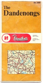
Map - Map of the Dandenongs, The Paul Hamlyn Group, c. 1970s
... This map of the Dandenongs c 1970s details tourist sites and walking tracks. ...The other side includes a street index, a list of tourist sites, a list of walking tracks, a map of Sherbrooke Forest, and a map of key approaches from the city to the Dandenongs....This map of the Dandenongs c 1970s details tourist sites and walking tracks. This map shows streets and walking tracks and tourist sites significant in the Dandenongs c. 1970s. ...George Broadbent was a Geelong-born cyclist record-holder, who produced from 1896 the most comprehensive and detailed maps of Victoria until his death in October 1947. His son had taken over map production in 1945. This map of the Dandenongs c 1970s details tourist sites and walking tracks. This map shows streets and walking tracks and tourist sites significant in the Dandenongs c. 1970s.Front of fold-out map titled 'The Dandenongs No. 199', produced by Broadbents. Folded out, one side is a street map of the Dandenongs. The other side includes a street index, a list of tourist sites, a list of walking tracks, a map of Sherbrooke Forest, and a map of key approaches from the city to the Dandenongs.On front: ' No. 199 / The / Dandenongs / Broadbents / Broadbents / Maps & Guides / A DIVISION OF / THE PAUL HAMLYN / GROUP'broadbents, dandenongs, 1970s, tourist sites, walking tracks -
 Kiewa Valley Historical Society
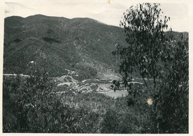
Photo - Bogong Township, September 1953
... Tourist Industry. The lake is one of the many water storage reservoirs used to supply the power stations their main power to run the huge turbines generating the final product, electricity Bogong Village SECV Faded handwritten inscription on back - Bogong Township taken from Little Arthur fire track. ...In 1940 Field Headquarters for the Kiewa Scheme were established at Bogong with office, workshop facilities and accommodation for workmen, staff and some families constructed. (There had been a 'tent camp' on this site in 1939 but was destroyed by bushfires) Construction of accommodation continued until 1947. A total of 40 houses plus a hostel for single staff, post office, police station, medical centre and primary school all with water and sewerage and electricity supply. The staff hostel was known as Kiewa House and is now occupied by the Education Department. Lake Guy was named after Mr. L.T. Guy who was the Resident Engineer in charge of construction work and associated activities on the Kiewa area. He held this position from 1939 to November 1946 when he was transferred to Head Office. The Bogong Township was developed firstly as an accommodation centre (base camp) for construction workers employed under the Kiewa Hydroelectric Scheme. Due to the influx of European workers into the Township the beautification of the immediate surrounds (gardens etc.) had a distinct European flavour. This environment has been very beneficial for tourism in later years. At the completion of the scheme, in the 1960's, the village was opened to public/tourism use. Strict environmental control has not allowed for any extensive redevelopment in tourist accommodation and basically restricted it to the accommodation initially built for the construction workers. Activities such a bike riding, snow skiing, restricted horse riding and bush walking on the Alpine plains and mountains are now a viable part of the Kiewa Valley Tourist Industry. The lake is one of the many water storage reservoirs used to supply the power stations their main power to run the huge turbines generating the final product, electricityBlack and white photograph of Bogong Township taken from Little Arthur fire track. September 1953Faded handwritten inscription on back - Bogong Township taken from Little Arthur fire track. Sept 1953bogong village, secv -
 Kiewa Valley Historical Society
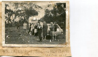
Photographs x 2- Bus tour of Wallaces Hut, 20/02/1970
... It is part of the early history of hydroelectricity in the state and has links with early SEC meteorological data recording in the area Apart from its historical significance, Wallace’s Hut is a popular stop for tourists and photographers and is the starting point for the Wallace’s Heritage trail, which is a popular and well used hiking track, by locals and visitors alike. ...Wallace's hut was built in 1889 and is probably the oldest surviving hut on the high plains of north-east Victoria. It was built in six weeks by Irish immigrant brothers Arthur, William and Stewart Wallace among old snow gums on a grassy plain above the snowline. The brothers held grazing leases on the High Plains and the hut was built to provide shelter for the cattlemen working there. It is probably the oldest hut on the Victorian high plains. It is part of the early history of hydroelectricity in the state and has links with early SEC meteorological data recording in the area Apart from its historical significance, Wallace’s Hut is a popular stop for tourists and photographers and is the starting point for the Wallace’s Heritage trail, which is a popular and well used hiking track, by locals and visitors alike.2 black and white photographs mounted on buff card. Photos taken during a bus trip to Wallace's Hut on Feb. 20, 1970 1. Group of local Kiewa Valley residents on a bus tour to Wallace's hut 2. Group of adults and children pictured outside Wallace's hut1. Handwritten in black ink on bottom of photo 'Wallace's Hut, Bogong High Plains, 20 Feb, 1970 2. No markingswallace's hut, bogong high plains, bush walking, cattlemen -
 Kiewa Valley Historical Society
Maps - Bogong x2, Tawonga, Omeo, Dargo, Victoria and others, 1. Bogong Alpine Area; 2. Bogong 8324; 3. Tawonga Topographical; 4. Omeo 8433; 5. Dargo 8323; 6. Victoria State
... tracks. 1. Bogong Alpine Area (outdoor Leisure Map. survey & Mapping Victoria, Government of Victoria, Edition 2, reprinted 1991 with an image of Mt. Feathertop on the front. Information for tourist ...1. Bogong Alpine Area (outdoor Leisure Map. survey & Mapping Victoria, Government of Victoria, Edition 2, reprinted 1991 with an image of Mt. Feathertop on the front. Information for tourist in the Alpine National Park: Bogong Area. Including: recreational activities, history, weather and vegetation and a list of walks together with locality maps and photographs. The front cover has an image of Mt Feathertop against a blue sky with yellow writing 'Bogong Alpine Area', there is a yellow triangular block on the right hand top corner with black writing 'Outdoor Leisure Map. On the bottom edge is a block of yellow with black writing 'Survey & Mapping Victoria' and a light green map of Victoria with 'VICMSP' printed in white. 2. 8324 Bogong Victoria, Edition 1, Commonwealth of Australia 1981. A topographical Map: 1:100,000 scale (1 cm to 1 KM). Map has a red cover with white writing together with a white block and black writing and a map insert. 3. Tawonga Topographical Map - Forests Commission Victoria, / revised 5/9/77, DEG No. 68-G/399. A Tawonga 803 folded map in a beige colour with the back blank. 4. Omeo 8433 Victoria, Edition 1, Department of Natural Resources. The map has a red and white cover with black writing and a simple map of Australia at the bottom. 5. 8323 Dargo, Edition 1, Commonwealth of Australia. A red and white cover with a map insert. 6. Victoria State Map, Hema Maps, 2002. Hema Maps, State Map, colourful cover with a map of Australia and four tourism photographs. Scale 1: 850,000 An inscription handwritten in blue pen "Trappers Gap to Mitta Mitta 1" to 1 mile". There are some pen markings and notations of tracks.maps, bogong, omeo, tawonga, dargo, victoria, bogong alpine area -
 Kiewa Valley Historical Society
Maps - Tourist
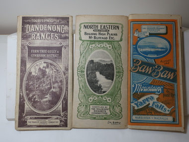
... Tourist map of the Dandenong Ranges. Brown cover. dated 6-4-33. Govt. printer showing roads, tracks in red and heights of the land. 2. ...Tourist map of the Dandenong Ranges. Brown cover. dated 6-4-33. Govt. printer showing roads, tracks in red and heights of the land. 2. ...These maps were all dated 1933 which was before the construction of the Kiewa Hydro Electric Scheme and when Tawonga was spelt Towonga. North East Victoria in 1933 was before the construction of the Kiewa Hydro Electric Scheme so the townships of Mt Beauty and Bogong are not shown. The description of the Snow Lines was important as skiers, bushwalkers and campers relied on them. The details on the map include "ADB. Numbered from A.1-377 round plates. CD Numbered from C 1-235 square plates. Poles about 3 chains apart 27 to the mile." 3 Tourist location maps (folded) and printed on parchment. 1. Tourist map of the Dandenong Ranges. Brown cover. dated 6-4-33. Govt. printer showing roads, tracks in red and heights of the land. 2. Tourist Map of Warburton, Mt Baw Baw, and Walhalla. Blue and Orange cover. dated 23-5-33 Govt. printer. 3 different maps of each area showin roads, tracks and timber tramways.Also in red and blue. 3. Tourist Map of North Eastern Victoria including Bogong High Plains Mt Buffalo Etc. Green cover. dated June 1933 Govt. printer. Main map and insert titled Bogong High Plains. Showing roads , tracks and tram ways. On insert showing snow poles. Also Red and Blue and mountains.By Authority of H.J. Green - 6 pence. Dept of Lands and Survey, Melbourne1933 maps, tourism maps, bogong high plains map 1933, snow poles -
 Port of Echuca
Coloured Photograph, 04/03/1984
... She has worked in the Wool Industry, the Timber Industry and the Tourist Industry. p.s. adelaide grassie, j.g port of echuca linklater, george poon boon station blair, david murray river darling river logging industry officer brothers. barmah forest fulton & shaw hutchinson, kevin murray downs station blackwood, adelaide On the orange front end loader are the numbers "5900" and the word "case." This is a coloured square photograph of an orange front end loader clearing a track ...The P.S Adelaide was launched on 21st July 1866. It was owned by J.G.Grassie from Poon Boon Station and the Officer Family of Murray Downs Station Swan Hill. The Adelaide was named after the niece of the Officer Bros, Adelaide Blackwood. The shipwright who built her was George Linklater. The Adelaide brought wool and passengers from the wool stations on the Murray and Darling Rivers down to the Echuca Wharf. In 1872 she was sold to David Blair & Sons. She was used to bring timber from the Barmah Forest to the Echuca Wharf. She did this work for the next 80 years. In 1953 she was tied up near the Mill and left. In 1958 she went to Paringa South Australia to work in the sawmill industry again. In 1960 the Echuca Apex Club and The Echuca Historical Society raised enough funds to buy the P.S. Adelaide and return her to Echuca. In November 1963 she was lifted out of the water and placed in Hopwood Gardens as this was thought to be a way of preserving her. In 1984 it was decided to return her to the water to resume work as a passenger vessel. In that time the Port of Echuca and the Echuca Wharf had been restored as a Tourist Precinct. This photograph shows the beginning of the task to return her to the river. It took several weeks in March 1984.The P.S Adelaide is extremely significant as it it the oldest known wooden hulled paddle steamers in the world. She was built in Echuca in 1866 and still operates on the Murray River today. She has worked in the Wool Industry, the Timber Industry and the Tourist Industry.This is a coloured square photograph of an orange front end loader clearing a track from Hopwood Gardens down to the river. The track was used to bring the P.S Adelaide from the gardens back into the river. The P.S Adelaide is in the background. The paddle steamer appears to be up on a trailer of some sort and is surrounded but plastic orange temporary fencing. There are small mounds of soil in the foreground.On the orange front end loader are the numbers "5900" and the word "case." p.s. adelaide, grassie, j.g, port of echuca, linklater, george, poon boon station, blair, david, murray river, darling river, logging industry, officer brothers., barmah forest, fulton & shaw, hutchinson, kevin, murray downs station, blackwood, adelaide -
 Halls Gap & Grampians Historical Society
Photograph - B/W, C 1960s
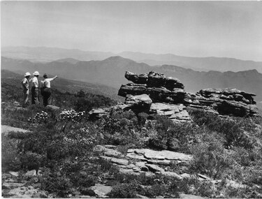
... A track to the top of Mt William existed many years before, an all weather road was constructed in the early 1960s Not only did engineers and construction workers enjoy some spectacular scenery during "smokos" but so have thousands of tourists Some even experiencing the freezing gale force winds which greeting Major Thomas Mitchell and his party in July 1836s...Halls Gap & Grampians Historical Society Centennial Hall 117-119 Grampians Road Halls Gap grampians A track to the top of Mt William existed many years before, an all weather road was constructed in the early 1960s Not only did engineers and construction workers enjoy some spectacular scenery during "smokos" but so have thousands of tourists Some even experiencing the freezing gale force winds which greeting Major Thomas Mitchell and his party in July 1836s ACCESS ROUTES Walking track Roads Mount William WMT (Wimmera Mail Times} Photo shows 3 men looking over to Wonderland Range from Mt William. ...A track to the top of Mt William existed many years before, an all weather road was constructed in the early 1960s Not only did engineers and construction workers enjoy some spectacular scenery during "smokos" but so have thousands of tourists Some even experiencing the freezing gale force winds which greeting Major Thomas Mitchell and his party in July 1836sPhoto shows 3 men looking over to Wonderland Range from Mt William. Two men are wearing hard hats The third man a felt hat - he is pointing to a point in the distanceWMT (Wimmera Mail Times}access routes, walking track, roads, mount william -
 Lorne Historical Society
Pamphlet - Tourist Brochure, Lovely Lorne
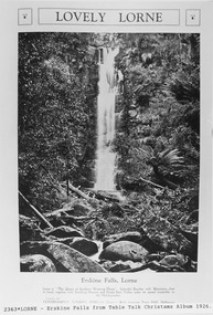
... A folded paper tourist brochure about Lorne The front cover is a coloured painting of Lorne from above the Erskine River towards the main beach. , on the back is a black and white sketch tourist map of the roads, tracks and beauty spots. Inside the first fold are 6 black and white photographs, Cumberland River, Mt St George, Phantom Falls, Cumberland Cliffs, Teddy’s Lookout, leafy walk towards the pier. ...Souvenirs Victorian Railways Publicity A folded paper tourist brochure about Lorne The front cover is a coloured painting of Lorne from above the Erskine River towards the main beach. , on the back is a black and white sketch tourist map of the roads, tracks and beauty spots. Inside the first fold are 6 black and white photographs, Cumberland River, Mt St George, Phantom Falls, Cumberland Cliffs, Teddy’s Lookout, leafy walk towards the pier. ...The Victorian Railways promoted tourist destinations around Victoria. A folded paper tourist brochure about Lorne The front cover is a coloured painting of Lorne from above the Erskine River towards the main beach. , on the back is a black and white sketch tourist map of the roads, tracks and beauty spots. Inside the first fold are 6 black and white photographs, Cumberland River, Mt St George, Phantom Falls, Cumberland Cliffs, Teddy’s Lookout, leafy walk towards the pier. Inside contains written descriptions of the highlights of Lorne and six black and white photographs, four general views of Lorne, Lover’s Walk, Erskine Falls . souvenirs, victorian railways, publicity -
 Lorne Historical Society
Pamphlet - Tourist pamphlet Lorne, Lorne Victoria Australia
... Inside are eight black and white photographs of Lorne attractions,; the Main Street, tennis courts, Erskine River, walking tracks and the George River with the phrase ,” The resort that embraces everything for the perfect holiday.” Lorne Victoria Australia Pamphlet Tourist pamphlet Lorne ...Victorian Railways printed a series of brochures publicizing holiday destinations.A folded paper souvenir pamphlet. The cover is a colored picture of Lorne from Scotsman’s Hill with two bathing suited young women in the foreground, and a blurb extolling the virtues of Lorne. On the back is a red, yellow and blue map of Lorne and district. Inside are eight black and white photographs of Lorne attractions,; the Main Street, tennis courts, Erskine River, walking tracks and the George River with the phrase ,” The resort that embraces everything for the perfect holiday.”souvenirs, pamphlets, victorian railways, -
 Eltham District Historical Society Inc
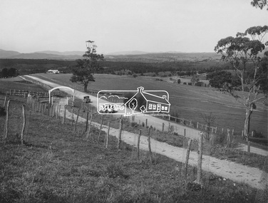
Photograph, Entrance to Shire of Eltham Memorial Park, Garden Hill, Eltham-Yarra Glen Road, Kangaroo Ground, c.1923
... track leading to the Park, and of carrying out other necessary works." A history summary of the Shire of Eltham Soldiers’ Memorial Park • The summit at Garden Hill was a popular tourist lookout and picnic spot from the 1880s. ...track leading to the Park, and of carrying out other necessary works." A history summary of the Shire of Eltham Soldiers’ Memorial Park • The summit at Garden Hill was a popular tourist lookout and picnic spot from the 1880s. ...View to south-east from Shire of Eltham Soldiers' Memorial Park showing the carriageway from the road to top of Memorial Park. Accompanying notes state that the entry gate was put in place in May 1921. Eltham and Whittlesea Shire Advertiser and Diamond Creek Valley Advocate Fri 21 May 1920 p 2 reported: Kangaroo Ground Memorial Park "It was decided to arrange for a working bee on Saturday, 29th inst., for the purpose of forming and gravelling the track leading to the Park, and of carrying out other necessary works." A history summary of the Shire of Eltham Soldiers’ Memorial Park • The summit at Garden Hill was a popular tourist lookout and picnic spot from the 1880s. Virtually the entire Shire of Eltham and beyond could be viewed from this location. • A local farmer, Mr Walter A. D. Wippell is credited as being the first to propose the idea of a war memorial park and offered £50 towards the purchase of the land. • The earliest public reference to this project is to be found in the local Advertiser newspaper edition of August 9th, 1918. A report of the August Council meeting records the Eltham Shire President, Cr. Robert White, saying: "some time back it was proposed that the Council obtain and place on an Honour Board in the Council Chamber [at Kangaroo Ground] containing names of the lads who had enlisted. Just recently however, it had been suggested that a more fitting memorial would be the obtaining of a piece of land on the summit of Garden Hill, Kangaroo Ground, and the formation of a memorial park in which a monument could be erected to represent the whole of Shire. If a couple of acres could be obtained a gentleman had promised to donate 50 pounds, and another one would fence it, and other contributions, he was sure, could be obtained." • Councillors were favourable of the proposal and the President, Shire Secretary and Shire Engineer were deputised to wait on Messrs Mess Bros. (the owners of the Garden Hill farm) and ascertain if they would gratuitously give the land. The Mess Bros. land adjoined the farm/stud of Mrs Fanny White (Cr Robert White’s mother), daughter of Andrew Harkness who established their property on Garden Hill around 1846. • Access to the land came in February 1919 when several Councillors and the Shire Engineer surveyed the actual two acres of '5 chains along the road and 4 chains deep'. The Engineer volunteered his services free to do this task. The Mess brothers however demanded £100 per acre but eventually agreed to take £50 per acre. • Entry from the Kangaroo Ground-Yarra Glen road was seen to be a problem and Mrs. White, who owned the land beside the park, was asked to donated a triangle of her property to allow this access. • By September 1919 returned soldiers were employed by the Shire and volunteers were called to clear the hilltop by ploughing up the rocks and clearing the area, the fencing was put into place and in May 1921 the Council erected three gates, within an archway, at the entrance to the drive and pathway to the summit. • Public subscriptions were sought through the Advertiser newspaper to beautify the site. The views of the Curator of the Melbourne Botanical Gardens were sought as to the ‘class of ornamental trees most suitable for planting in the Park area”. • The Memorial Park or Shire of Eltham Soldiers’ Memorial Park was officially opened by Mr. W.H. Everard, M.L.A., 3 September 1921. • In 1922 plans were made to place a War Memorial in the Park. Funds were donated by the Council of £250 and a challenge to the community, to match this money with contributions was met. • On Anzac Day 1923, 1,000 people gathered on the summit in the park for a memorial service. A much smaller group of about 50 people gathered around a newly constructed cairn and flagstaff in the afternoon of Anzac Day 1924 amidst rain and a squally southerly wind, the morning service being cancelled. • A meeting for those interested in establishing a War Memorial monument within the park was held in January 1924 and the Eltham Shire War Memorial League was formed and a design competition decided upon. • The Shire of Eltham War Memorial tower was built in 1926 at a cost of £1,023 and 5 shillings with locally quarried stone donated by Dr Ethel and Professor William Osborne. It was formally known as the ‘Shire of Eltham War Memorial’ and was unveiled on 11 November 1926. The large bronze inscription above the entrance to the tower states: SHIRE OF ELTHAM WAR MEMORIAL THESE MEN DIED FOR THEIR COUNTRY 1914 IN REMEMBRANCE THIS TOWER WAS BUILT 1918 • The Caretaker’s hut was built in 1927 with left over from the tower construction. • A returned soldier was appointed to act as caretaker for the memorials. Tiny Carrol, a huge man, was the first caretaker and lived in the stone hut. There was a push to have alterations made at one stage to provide additional rooms for a married caretaker but was rejected. • A new Caretaker Cottage was built in 1951 at a cost £2,500. The cottage had been subjected to raids by thieves three times during construction until a guard from the Returned Servicemen’s League was posted until its opening. • The War Memorial tower was re-dedicated by Sir Dallas Brooks on 8 November 1951, unveiling new bronze plaques containing the names of those who fell during the Second World War. Sir Dallas also officiated the opening of the new Caretaker’s Cottage. • A toilet block was built in 1965. • A further dedication of the Shire of Eltham War Memorial tower took place 11 November 2001 to recognise the men who fell in subsequent campaigns up to and including Vietnam. • Four land titles are involved: o The purchase of the two acres from owners Ruth Gosling, Alexander Mess, James Johnson Mess and Joseph Mess is recorded in two actions, the first being the payment of £100 for the two acres, the second showing that the Shire of Eltham did not get a transfer of title until 14th January 1952. o The access land donated by Mrs. Fanny White is dated 26 February 1924. A further need to widen the entry came after the deepening of the road cutting and another land donation was given by Sir Herbert Gepp, title dated 15th May 1952. This would have been about the time he sold off the former White ‘Garden Hill’ property. o The land reserve to increase the area and possibly allow a circuit road to be put in place on the western side of the park was purchased by the Shire of Eltham, title dated 16th February 1973. Rare photograph of the entrance to the Shire's Memorial Park during early stages of development prior to the erection of the Shire of Eltham War MemorialSepia photograph printed with white border with slight crack lower left hand corner and three significant vertical cracks fanning from lower centre edge to upper edge Digitally enhanced version to minimise impact of crackseltham-yarra glen road, entrance gate, garden hill, kangaroo ground, shire of eltham memorial park, shire of eltham war memorial, kangaroo ground war memorial park -
 Orbost & District Historical Society
programs, 1961
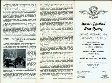
... track was for stock, made by pioneers many years ago, and it was very circuitous. It was stated at a meeting at Dalgety that the road would open up large areas for settlement for grazing, and for timber suitable for bridgé building. The road would assist stock deal ing between Monaro and Gippsland. It would also considerably shorten the distance from Victoria for tourists...track was for stock, made by pioneers many years ago, and it was very circuitous. It was stated at a meeting at Dalgety that the road would open up large areas for settlement for grazing, and for timber suitable for bridgé building. The road would assist stock deal ing between Monaro and Gippsland. It would also considerably shorten the distance from Victoria for tourists ...The Snowy River Shire was a local government area in the Australian Alps region of New South Wales, Australia from 1939 until May 2016. It was named after the Snowy River that runs through it. Prior to 1936, it had been named as Dalgety Shire since establishment in 1906. This opening of the Monaro - Gippsland Road took place on 4th May 1961. There had long been a movement in Monaro for the construction of a road to connect Monaro and Gippsland, via Inglebyra and Black Mountain. The only track was for stock, made by pioneers many years ago, and it was very circuitous. It was stated at a meeting at Dalgety that the road would open up large areas for settlement for grazing, and for timber suitable for bridgé building. The road would assist stock deal ing between Monaro and Gippsland. It would also considerably shorten the distance from Victoria for tourists visiting Canberra and Kosciusko. A committee was formed to put the proposal before the Dalgety Shire Council in the 1930s.This item is a useful research tool.Four copies of a road opening program. It has black print on white. There are black / white photographs, historical details and details of the official opening.program monaro-road snowy-river-shire -
 Ballarat Tramway Museum
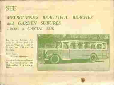
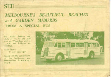
Booklet, Melbourne and Metropolitan Tramways Board (MMTB), "See Melbourne's Beautiful Beaches and Garden Suburbs from a Special Bus", 1938
... tourist bus, giving overall tour details on page 1, including fares, time of departures and reservations. Each tour has a map showing the route, details of the tour route with notes and photographs. Page 14 shows a maximum traction tram on the reserved track...tourist bus, giving overall tour details on page 1, including fares, time of departures and reservations. Each tour has a map showing the route, details of the tour route with notes and photographs. Page 14 shows a maximum traction tram on the reserved track ...The book advertising MMTB's Special tourist bus, giving overall tour details on page 1, including fares, time of departures and reservations. Each tour has a map showing the route, details of the tour route with notes and photographs. Page 14 shows a maximum traction tram on the reserved track in Dandenong road and page 13, W2 488 outbound in Victoria Parade. Page 31has an advertisement for the Round Trip by Tram 1/-. Inside Front cover has details of the departure times and fares and a photo of the Tourist Bus. The supplementary sheet has been prepared for the tours that operated daily from Sun Sept. 18 to Friday May 31, except Anzac Day. For the 1939-1940 version - different bus on cover. - Reg Item 1838.Demonstrates the work of the MMTB providing sightseeing tours using a special bus and its publicity methods.Thirty two page landscape booklet on semi gloss white paper with off white or cream cover and single supplementary white sheet tipped onto the inside of the front cover titled "See Melbourne's Beautiful Beaches and Garden Suburbs from a Special Bus". Saddle stapled, printed letterpress. Text printed in black and green ink. Cover green ink only.tramways, trams, mmtb, melbourne, bus tours, sightseeing -
 Ballarat Tramway Museum
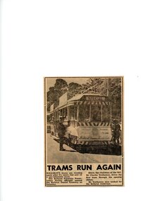
Newspaper - Newspaper - Clipping and Black & White Photograph, Trams run again, 1975
... It was run over a one and a half kilometre track and driven by Mr Trethowan, chairman of the SEC and former tram driver at Ballarat tramways. newspapaer photograph trams ballarat tramway preservation society ballarat tourist tramway trams run again sec 1975 ron bridger collection mr trethowan sec chairman AS Box 48A Newspaper clipping with balck and white photograph Trams run again, 1975 Newspaper Newspaper - Clipping and Black & White Photograph ...Ron Bridger was an avid collector of items related to Transport, predominantly Trams. These items include newspaper cuttings, pamphlets, reports, timetables, fares prices plus special items relating to events. Items from Melbourne and regional Victoria, Interstate - Sydney and Adelaide, plus overseas, make up this collection. Article shows photograph of the tram that ran again after three and a half years. It was run over a one and a half kilometre track and driven by Mr Trethowan, chairman of the SEC and former tram driver at Ballarat tramways.Newspaper clipping with balck and white photographnewspapaer photograph, trams, ballarat tramway preservation society, ballarat tourist tramway, trams run again, sec, 1975, ron bridger collection, mr trethowan, sec chairman, as box 48a -
 Ballarat Tramway Museum
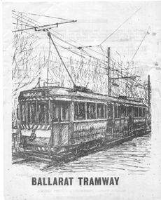
Pamphlet - advertising the Museum, Ballarat Tramway Preservation Society (BTPS), 1975
... Pamphlet advertising the Museum, with a sketch of tram 40, with the name "Ballarat Tourist Tramway" on the rear and giving visiting details and fares. Has a map on the rear showing the location and track along Wendouee Parade. ...Ballarat Tramway Museum South Gardens Reserve Wendouree Parade Ballarat Ballarat goldfields Pamphlet advertising the Museum, with a sketch of tram 40, with the name "Ballarat Tourist Tramway" on the rear and giving visiting details and fares. Has a map on the rear showing the location and track along Wendouee Parade. ...Pamphlet advertising the Museum, with a sketch of tram 40, with the name "Ballarat Tourist Tramway" on the rear and giving visiting details and fares. Has a map on the rear showing the location and track along Wendouee Parade. See item 6296 for an earlier example. Yields information about BTPS Marketing c1975.Duplicated quarto sheet two sided on white paper.tramways, ballarat, btps, map, drawings, sketches, fares, operations -
 Ballarat Tramway Museum
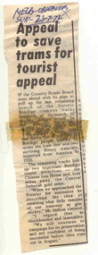
Newspaper, Melbourne Observer, "Appeal to save trams for tourist appeal", 23/07/1972 12:00:00 AM
... Clipping from the Melbourne Observer, Sun 23/7/1972 titled "Appeal to save trams for tourist appeal", regarding the retention of Bendigo tram tracks between the Joss House and the Central Deborah Mine and their discussions with the Premier - "gimmickry". ...Ballarat Tramway Museum South Gardens Reserve Wendouree Parade Ballarat Ballarat goldfields Bendigo Reopening Closure In ink "Melb-Observer Sun 23-7/72" Clipping from the Melbourne Observer, Sun 23/7/1972 titled "Appeal to save trams for tourist appeal", regarding the retention of Bendigo tram tracks between the Joss House and the Central Deborah Mine and their discussions with the Premier - "gimmickry". ...Clipping from the Melbourne Observer, Sun 23/7/1972 titled "Appeal to save trams for tourist appeal", regarding the retention of Bendigo tram tracks between the Joss House and the Central Deborah Mine and their discussions with the Premier - "gimmickry". In ink "Melb-Observer Sun 23-7/72"bendigo, reopening, closure -
 Ballarat Tramway Museum
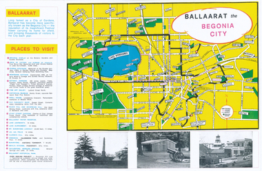
Pamphlet, Earl Ewers, "Ballaarat Begonia Festival - 1971", Sep. 2011
... Tourist Bureau. Trams tramways Begonia Festival Ballarat Map Colour photocopy of a advertising brochure for the 1971 Ballaarat Begonia Festival - copied onto two A3 sheets. Has a map of the city showing the tram tracks ...Yields information about the form of advertising the Ballarat Begonia Festival undertook and the relationship with Victour, the Victorian Govt. Tourist Bureau.Colour photocopy of a advertising brochure for the 1971 Ballaarat Begonia Festival - copied onto two A3 sheets. Has a map of the city showing the tram tracks, bowling greens, parks, and various locations. Gives Places to visit, programmes and Victour addresses and details. Originally published by the Ballaarat Begonia Festival Association and the Greater Ballarat Association and printed by Hedges and Bell. Three copies held. See Reg Item 2154 for the actual festival programme.trams, tramways, begonia festival, ballarat, map -
Ballarat Tramway Museum
Newspaper, Mariza Fiamengo, "Tram plans continue on track", 2/05/2001 12:00:00 AM
... tourist attractions through a tram system. Gives some background and quotes from Michael Ronaldson, Peter Winspur, Eugene Kneebone and Dianne Smith. "Tram plans continue on track ...Newspaper cutting from The Courier, Ballarat, 2 May 2001, written by Mariza Fiamengo advising that the Federal Government had made a $73,000 grant for a feasibility study of linking Ballarat's major tourist attractions through a tram system. Gives some background and quotes from Michael Ronaldson, Peter Winspur, Eugene Kneebone and Dianne Smith."The Courier, Ballarat, Wednesday 2 May 2001" in a box on the left hand side of the cutting.tram reinstatement, federal grant, feasibility study, city tramway -
 Ballarat Tramway Museum
Book, Melbourne and Metropolitan Tramways Board (MMTB), "See Melbourne's Beautiful Beaches and Garden Suburbs from a Special Bus", 1940
... tourist bus, giving overall tour details on page 1, including fares, time of departures and reservations. Each tour has a map showing the route, details of the tour route with notes and photographs. Page 14 shows a maximum traction tram on the reserved track...tourist bus, giving overall tour details on page 1, including fares, time of departures and reservations. Each tour has a map showing the route, details of the tour route with notes and photographs. Page 14 shows a maximum traction tram on the reserved track ...The book advertising MMTB's Special tourist bus, giving overall tour details on page 1, including fares, time of departures and reservations. Each tour has a map showing the route, details of the tour route with notes and photographs. Page 14 shows a maximum traction tram on the reserved track in Dandenong road and page 30, W2 488 outbound in Victoria Parade. Page 32 has an advertisement for the Round Trip by Tram 1/-. Front cover has details of the departure times and fares and a photo of the Tourist Bus. The supplementary sheet has been prepared for the tours that operated daily from Sun Sept. 17 to Friday May 31, except Anzac Day. See item 10133 for the 1938 version.Demonstrates the work of the MMTB providing sightseeing tours using a special bus and its publicity methodThirty two page landscape booklet on semi gloss white paper with off white cover and single supplementary white sheet tipped onto the inside of the front cover titled "See Melbourne's Beautiful Beaches and Garden Suburbs from a Special Bus". Saddle stapled, printed letterpress. Text printed in black and green ink. Cover green ink only. trams, tramways, mmtb, bus tours, melbourne, sightseeing -
 Ballarat Tramway Museum
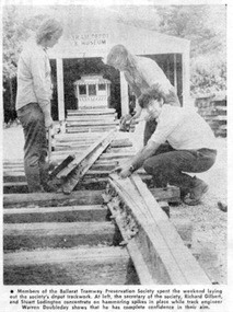
Newspaper, The Courier Ballarat, "Tourist Tram May operate in time for the Festival", 26/12/1972 12:00:00 AM
... track BTPS Begonia Festival In red ink in top right hand corner "26/12/72" Newspaper clipping from The Courier, 26/12/1972 about the BTPS's hopes to have the tramway operable in time for the Begonia Festival in March! Quotes Richard Gilbert, Society Secretary about the work being carried out, progress so far and that the work is being done by Volunteers. Features a photo of Richard Gilbert, Stuart Lodington and Warren Doubleday in front of the depot, laying 2 to 3 road points. See Reg Item 3822 for a print of the actual photograph. "Tourist ...Yields information about the construction of the Trackwork on the depot fan and some of the people who undertook the work.Newspaper clipping from The Courier, 26/12/1972 about the BTPS's hopes to have the tramway operable in time for the Begonia Festival in March! Quotes Richard Gilbert, Society Secretary about the work being carried out, progress so far and that the work is being done by Volunteers. Features a photo of Richard Gilbert, Stuart Lodington and Warren Doubleday in front of the depot, laying 2 to 3 road points. See Reg Item 3822 for a print of the actual photograph.In red ink in top right hand corner "26/12/72"trams, tramways, ballarat, access track, btps, begonia festival