Showing 2691 items matching "township"
-
 Buninyong & District Historical Society
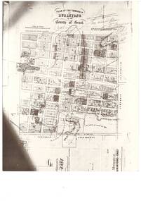
Photograph - Black and white photograph of Plan of the Township of Buninyong, Plan of the Township of Buninyong in the County of Grant March 18 1856
... Plan of the Township of Buninyong in the County of Grant March 18 1856...A photograph of the Plan of the Township of Buninyong from the Surveyor Generals Office Melbourne March 1856...A black and white photograph showing the Plan of the Township of Buninyong..."Plan of the Township of Buninyong County of Grant", Surveyor Generals Office Melbourne 18th March 1856, various handwritten notations...A photograph of the Plan of the Township of Buninyong from the Surveyor Generals Office Melbourne March 1856 The map is one of the earliest of Buninyong and shows some notations indicating some allocations of land that were revoked and possibly the location of tannery dam Buninyong Township Maps "Plan of the Township of Buninyong County of Grant", Surveyor Generals Office Melbourne 18th March 1856, various handwritten notations A black and white photograph showing the Plan of the Township of Buninyong Plan of the Township of Buninyong in the County of Grant March 18 1856 Photograph Black and white photograph of Plan of the Township of Buninyong ...A photograph of the Plan of the Township of Buninyong from the Surveyor Generals Office Melbourne March 1856The map is one of the earliest of Buninyong and shows some notations indicating some allocations of land that were revoked and possibly the location of tannery damA black and white photograph showing the Plan of the Township of Buninyong"Plan of the Township of Buninyong County of Grant", Surveyor Generals Office Melbourne 18th March 1856, various handwritten notationsbuninyong township, maps -
 Emerald Museum & Nobelius Heritage Park
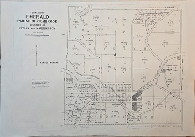
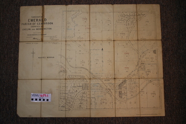
Map - Image of surveyor's map of the Township of Emerald, Surveyors map, Emerald Township 1955, c1955
... Surveyors map, Emerald Township 1955...Emerald township map c1955...Image of surveyor's map - Township of Emerald 1955...Township of Emerald/parish of Gembrook/Counties of Evelyn & Mornington/By Authority W.M.Huston, Government Printer/Drawn and reproduced at the Dept. of Lands and Survey, Melbourne, Victoria, September 1955...Emerald Museum & Nobelius Heritage Park 5 Crichton Rd Emerald yarra-valley-and-the-dandenong-ranges Emerald township map c1955 Township of Emerald/parish of Gembrook/Counties of Evelyn & Mornington/By Authority W.M.Huston, Government Printer/Drawn and reproduced at the Dept. of Lands and Survey, Melbourne, Victoria, September 1955 Image of surveyor's map - Township of Emerald 1955 Surveyors map, Emerald Township 1955 Map Image of surveyor's map of the Township of Emerald ...Emerald township map c1955Image of surveyor's map - Township of Emerald 1955Township of Emerald/parish of Gembrook/Counties of Evelyn & Mornington/By Authority W.M.Huston, Government Printer/Drawn and reproduced at the Dept. of Lands and Survey, Melbourne, Victoria, September 1955 -
 Marysville & District Historical Society
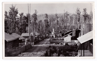
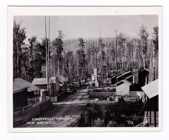
Postcard (item) - Black and white postcard, Valentine Publishing Co. Pty. Ltd, CAMBARVILLE TOWNSHIP, NEAR MARYSVILLE, 1923-1963
... CAMBARVILLE TOWNSHIP, NEAR MARYSVILLE....An early black and white postcard of the township of Cambarville near Marysville in Victoria. ...An early black and white postcard of the township of Cambarville near Marysville in Victoria. ...CAMBARVILLE TOWNSHIP, NEAR MARYSVILLE V.35. VALENTINE'S/ POST CARD A GENUINE PHOTOGRAPH...An early black and white postcard of the township of Cambarville near Marysville in Victoria. ...An early black and white postcard of the township of Cambarville near Marysville in Victoria. Cambarville was established as a timber mill town in the 1940s. Timber mill owners A. Cameron and F.J. Barton named Cambarville. They established the mill to salvage timber from trees destroyed in the 1939 bushfires. Cambarville was impacted by the 2009 Black Saturday bushfires and any remaining structures were destroyed. This postcard was produced by Valentine's Publishing Co as a souvenir of Marysville.An early black and white postcard of the township of Camberville near Marysville in Victoria. CAMBARVILLE TOWNSHIP, NEAR MARYSVILLE V.35. VALENTINE'S/ POST CARD A GENUINE PHOTOGRAPHmarysville, victoria, souvenir, 1939 bushfires, 2009 black saturday bushfires, postcard, valentine's publishing co, a. cameron, f.j. barton -
 Orbost & District Historical Society
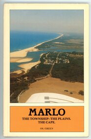
Booklet - MARLO THE TOWNSHIP: THE PLAINS, THE CAPE, Os. Green, 1984
... MARLO THE TOWNSHIP: THE PLAINS, THE CAPE ...Cream booklet with an aerial photo of the Marlo township and area, Snowy River and sea. Black writing in an orange coloured box....MARLO THE TOWNSHIP: THE PLAINS, THE CAPE. OS. GREEN...Green MARLO THE TOWNSHIP: THE PLAINS, THE CAPE. OS. GREEN Cream booklet with an aerial photo of the Marlo township and area, Snowy River and sea. ...History booklet of the Marlo district written by OS. Green. Contains photos, maps, diagrams. Dated from 1875 to 1983This booklet is significant because it describes the history, in detail, the area around Marlo.Cream booklet with an aerial photo of the Marlo township and area, Snowy River and sea. Black writing in an orange coloured box.MARLO THE TOWNSHIP: THE PLAINS, THE CAPE. OS. GREENmarlo, marlo and district, snowy river, os. green -
 Rutherglen Historical Society
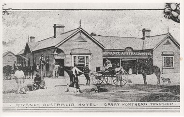
Image, Advance Australia Hotel - Great Northern Township, c1893
... Advance Australia Hotel - Great Northern Township...Great Northern Township, Victoria, Australia...Advance Australia Hotel - Great Northern Township Image ...Black and white photograph of a hotel, with a number of people, dogs and horses, and two horse carts shown in the foreground.Written on back of photo "Opened 19/4/1893"advance australia hotel, hotels -
 Eltham District Historical Society Inc
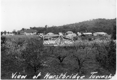
Photograph, View of Hurstbridge township
... View of Hurstbridge township...View across an orchard of flowering fruit trees towards the small township of Hurstbridge. Around 1920s....View of Hurstbridge township...It is significant in being the first community sourced collection representing the places and people of the Shire's first one hundred years. sepp shire of eltham pioneers photograph collection hurstbridge orchards View of Hurstbridge township Digital image View of Hurstbridge township Photograph Photograph ...View across an orchard of flowering fruit trees towards the small township of Hurstbridge. Around 1920s.This photo forms part of a collection of photographs gathered by the Shire of Eltham for their centenary project book, "Pioneers and Painters: 100 years of the Shire of Eltham" by Alan Marshall (1971). The collection of over 500 images is held in partnership between Eltham District Historical Society and Yarra Plenty Regional Library (Eltham Library) and is now formally known as 'The Shire of Eltham Pioneers Photograph Collection.' It is significant in being the first community sourced collection representing the places and people of the Shire's first one hundred years.Digital imageView of Hurstbridge townshipsepp, shire of eltham pioneers photograph collection, hurstbridge, orchards -
 Tatura Irrigation & Wartime Camps Museum
Photograph, Eildon Township, 1957
... Eildon Township...Aerial photograph - looking down on township in middle foreground - overflow dam to the right, middle distance - dam wall with reservoir beyond - mountain tops forming horizon...On frame below photo: "Eildon Township."...Aerial photograph - looking down on township in middle foreground - overflow dam to the right, middle distance - dam wall with reservoir beyond - mountain tops forming horizon Eildon Township Photograph ...Taken by photographer for State Rivers and Water Supply Commission.Medium sized black and white photo. Aerial photograph - looking down on township in middle foreground - overflow dam to the right, middle distance - dam wall with reservoir beyond - mountain tops forming horizonOn frame below photo: "Eildon Township."victoria state rivers and water supply commission, eildon -
 Buninyong & District Historical Society
Artwork, other - Colour reproduction of lithograph "Township of Buninyong" c1852, "Township of Buninyong" c1852
... "Township of Buninyong" c1852...Colour reproduction of lithograph "Township of Buninyong" c1852 from the cover of "Three Times Blest"...Henry Winkles Township of Buninyong c 1852 Lithograph, originally published in Montgomery Martin's "Australia" Reproduced "Three Times Blest"...Buninyong & District Historical Society Old Court House, Buninyong Town Hall 313 Learmonth Street Buninyong goldfields Early image of Buninyong c1852 showing evidence of land clearing, cultivation, residential and farm buildings and Mount Buninyong with tree cover Buninyong was one of the earliest settlements Victoria and became a very important place in the history of the goldrush Early settlement Henry Winkles Mount Buninyong Buninyong Henry Winkles Township of Buninyong c 1852 Lithograph, originally published in Montgomery Martin's "Australia" Reproduced "Three Times Blest" Colour reproduction of lithograph "Township of Buninyong" c1852 from the cover of "Three Times Blest" "Township of Buninyong" c1852 Artwork, other Colour reproduction of lithograph "Township of Buninyong" c1852 ...Early image of Buninyong c1852 showing evidence of land clearing, cultivation, residential and farm buildings and Mount Buninyong with tree coverBuninyong was one of the earliest settlements Victoria and became a very important place in the history of the goldrushColour reproduction of lithograph "Township of Buninyong" c1852 from the cover of "Three Times Blest"Henry Winkles Township of Buninyong c 1852 Lithograph, originally published in Montgomery Martin's "Australia" Reproduced "Three Times Blest"early settlement, henry winkles, mount buninyong, buninyong -
 Marysville & District Historical Society
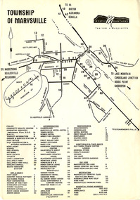
Flyer (Item) - Town map, Mystic Mountains Tourism, TOWNSHIP OF MARYSVILLE, Unknown
... TOWNSHIP OF MARYSVILLE...A map of the township of Marysville published by Mystic Mountains Tourism in Marysville. ...A map of the township of Marysville published by Mystic Mountains Tourism in Marysville....TOWNSHIP OF MARYSVILLE Flyer Town map Mystic Mountains Tourism ...A map of the township of Marysville published by Mystic Mountains Tourism in Marysville. The map shows a legend of various services, accommodation sites, shops restaurants and recreation spots in the township.A map of the township of Marysville published by Mystic Mountains Tourism in Marysville.marysville, victoria, australia, mystic mountains tourism, map -
Hume City Civic Collection
Map, Sunbury Township 1857
... Sunbury Township 1857...This is a reprint of a 1857 map of the township of Sunbury in the County of Bourke produced by the Public Records Office by courtesy of the Surveyor General in 1978....This is a reprint of a 1857 map of the township of Sunbury....Sunbury Township 1857 Map Map ...This is a reprint of a 1857 map of the township of Sunbury in the County of Bourke produced by the Public Records Office by courtesy of the Surveyor General in 1978.This is a reprint of a 1857 map of the township of Sunbury.sunbury, shire of bulla, sunbury township, 1850s -
 Linton and District Historical Society Inc
Photograph, Piggoreet Township
... Piggoreet Township...Piggoreet Township developed very quickly after gold was discovered in the Springdallah area (at that time called Spindella) in the 1850s. ...Copy of original photograph which shows roads, buildings, general layout of the former township at Piggoreet....Piggoreet Township Photograph ...Piggoreet Township developed very quickly after gold was discovered in the Springdallah area (at that time called Spindella) in the 1850s. By the early 1860s the township had a population in the hundreds, as well as shops, a school, a police station and court house, hotels and churches.Copy of original photograph which shows roads, buildings, general layout of the former township at Piggoreet.piggoreet township -
 Marysville & District Historical Society
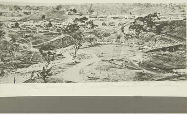
Flyer (item) - Information Flyer, Parks Victoria, park notes-Yarra Ranges National Park-Lady Talbot Drive and Cambarville Historic Township, June 2013
... park notes-Yarra Ranges National Park-Lady Talbot Drive and Cambarville Historic Township...A flyer produced by Parks Victoria of information on Lady Talbot Drive and Cambarville Historic Township....A flyer produced by Parks Victoria of information on Lady Talbot Drive and Cambarville Historic Township....Marysville & District Historical Society 39 Darwin Street Marysville yarra-valley-and-the-dandenong-ranges A flyer produced by Parks Victoria of information on Lady Talbot Drive and Cambarville Historic Township. A flyer produced by Parks Victoria of information on Lady Talbot Drive and Cambarville Historic Township. ...A flyer produced by Parks Victoria of information on Lady Talbot Drive and Cambarville Historic Township.A flyer produced by Parks Victoria of information on Lady Talbot Drive and Cambarville Historic Township. Lady Talbot Drive a 24 kilometer scenic rainforest car journey which passes a number of walks and waterfalls in the Yarra Ranges National Park. Lady Talbot Drive is named after Lady Sarah Elizabeth, the wife of Sir Reginald Talbot, who was the Governor of Victoria from 25th April, 1904 to 6th July 1908. Cambarville is notable for its giant mountain ash (Eucalyptus regnans) trees within the Cumberland Memorial Scenic Reserve, and relics from former sawmills and gold mining. The Big Culvert is located nearby on the Marysville-Woods Point Road, which was historically part of the Yarra Track. Cambarville was established as a timber mill town in the 1940s. Timber mill owners A Cameron and FJ Barton named Cambarville. They established the mill to salvage timber from trees destroyed in the 1939 bushfires. Cambarville was impacted by the 2009 Black Saturday bushfires and any remaining structures were destroyed. parks victoria, yarra ranges national park, lady talbot drive, lady talbot forest drive, cambarville, taggerty river, sir reginald talbot, lady sarah elizabeth talbot, phantom falls, keppel falls, keppel falls lookout, beeches rainforest walk, big culvert, cumberland walk, the big tree, the sitka spruce, cora lynn falls, sovereign view -
Marysville & District Historical Society
Ephemera (Item) - Information brochure, Artworkz Tourism, MARYSVILLE TOWNSHIP, 11-2020
... MARYSVILLE TOWNSHIP...An information brochure on the township of Marysville in Victoria. This brochure was produced by Artworkz Tourism in November 2020....An information brochure on the township of Marysville in Victoria. This brochure was produced by Artworkz Tourism in November 2020....MARYSVILLE TOWNSHIP Ephemera Information brochure Artworkz Tourism ...An information brochure on the township of Marysville in Victoria. This brochure was produced by Artworkz Tourism in November 2020.An information brochure on the township of Marysville in Victoria.Disclaimer: The authors have taken care to ensure this/ publication is correct, though please be aware that/ errors and omissions do occur.marysville, victoria, australia, information brochure, artworkz tourism, 2009 black saturday bushfires, bruno's sculpture garden, steavenson falls, gallipoli lake, keppel falls, lady talbot drive, cora lynn falls, cambarville walk, phantom falls, taggerty river visitor area, meeting of the waters, the beeches, cambarville day visitor area, the big tree, keppel hut, keppel lookout, mount gordon, marysville golf course, jock's lookout, gallipoli park, yellow dog day visitor area -
 Ringwood and District Historical Society
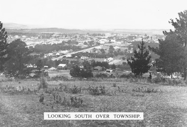
Photograph, Looking south over Ringwood township from Loughnans Hill c1930. Ringwood Street is the main road in the centre
... Looking south over Ringwood township from Loughnans Hill c1930. Ringwood Street is the main road in the centre....Black and white photograph taken from hill overlooking township of Ringwood. (3 copies)...Printed on photograph, "Looking south over township". Typed below photograph, "View from Loughnans Hill c1930. ...Black and white photograph taken from hill overlooking township of Ringwood. (3 copies) Looking south over Ringwood township from Loughnans Hill c1930. ...Black and white photograph taken from hill overlooking township of Ringwood. (3 copies)Printed on photograph, "Looking south over township". Typed below photograph, "View from Loughnans Hill c1930. Ringwood Street is the main road in the centre. Old St. Pauls, railway crossing, Methodist church, state school, coolstores, etc. can all be seen". -
 Marysville & District Historical Society
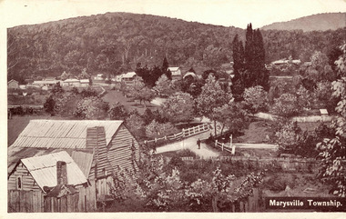
Postcard (item) - Black and white postcard, Marysville Township, 1936
... Marysville Township...A digital copy of a black and white postcard of the view of the Marysville township taken from the Steavenson Hotel....A digital copy of a black and white postcard of the view of the Marysville township taken from the Steavenson Hotel....Marysville Township Postcard Black and white postcard ...A digital copy of a black and white postcard of the view of the Marysville township taken from the Steavenson Hotel.A digital copy of a black and white postcard of the view of the Marysville township taken from the Steavenson Hotel.marysville, victoria, australia, steavenson hotel, poontawan, marysville chalet, george wright, pack road, wood's point road, wood's point mountaineer, albion restaurant, steavenson's creek, yarra track, bridge inn, butler's woods point general directory 1866, postcard -
 Emerald Museum & Nobelius Heritage Park
Two maps of Emerald Township 1955 and 1922, Emerald Township
... Emerald Township...They are early maps of Emerald Township in 1955 and 1922....VEMU1659.1 Township of Emerald, Parish of Gembrook, Counties of Evelyn and Mornington; September 1955 VEMU1659.2 Township of Emerald, Parish of Gembrook, Counties of Evelyn and Mornington: Drafted 12 Sep 1892, Examined 30 Sep 1892, Additions 17 Jun 1922...They are early maps of Emerald Township in 1955 and 1922. VEMU1659.1 Township of Emerald, Parish of Gembrook, Counties of Evelyn and Mornington; September 1955 VEMU1659.2 Township of Emerald, Parish of Gembrook, Counties of Evelyn and Mornington: Drafted 12 Sep 1892, Examined 30 Sep 1892, Additions 17 Jun 1922 Emerald Township Two maps of Emerald Township 1955 and 1922 ...The Photo Lithographed Maps belonged to George and Mary A'Vard. They are early maps of Emerald Township in 1955 and 1922.VEMU1659.1 Township of Emerald, Parish of Gembrook, Counties of Evelyn and Mornington; September 1955 VEMU1659.2 Township of Emerald, Parish of Gembrook, Counties of Evelyn and Mornington: Drafted 12 Sep 1892, Examined 30 Sep 1892, Additions 17 Jun 1922 -
![View of the township of Golden Square / [by] Nicholas Caire, circa 1876](/media/collectors/550653872162f11fb04854aa/items/578340aed0cdd1176c6899f4/item-media/5783411dd0cdd1176c68c568/item-fit-380x285.jpg?cb=6) Kew Historical Society Inc
Kew Historical Society IncPhotograph, Anglo-Australasian Photographic Company, View of the township of Golden Square, c. 1876
... View of the township of Golden Square...‘View of the township of Golden Square’ : Views of Victoria (General Series) No.57 : Albumen silver photograph | Photo on card with Title and Description on reverse | Mounted 24 x 30 cm; Photo 12 x 17 cm....The Church in the distance is that of the Wesleyan body. It was in this township that gold was first discovered in the district of Bendigo.’...View of the township of Golden Square Photograph Photograph Anglo-Australasian Photographic Company ...Nicholas Caire was born on Guernsey in the Channel Islands in 1837. He arrived in Adelaide with his parents in about 1860. In 1867, following photographic journeys in Gippsland, he opened a studio in Adelaide. From 1870 to 1876 he lived and worked in Talbot in Central Victoria. In 1876 he purchased T. F. Chuck's studios in the Royal Arcade Melbourne. In 1885, following the introduction of dry plate photography, he began a series of landscape series, which were commercially successful. As a photographer, he travelled extensively through Victoria, photographing places few of his contemporaries had previously seen. He died in 1918. Reference: Jack Cato, 'Caire, Nicholas John (1837–1918)', Australian Dictionary of Biography.An original, rare photograph from the series 'Views of Victoria: General Series' by the photographer, Nicholas Caire (1837-1918). The 60 photographs that comprise the series were issued c. 1876 and reinforced a neo-Romantic view of the Australian landscape to which a growing nationalist movement would respond. Nicholas Caire was active as a photographer in Australia from 1858 until his death in 1918. His vision of the Australian bush and pioneer life had a counterpart in the works of Henry Lawson and other nationalist poets, authors and painters.‘View of the township of Golden Square’ : Views of Victoria (General Series) No.57 : Albumen silver photograph | Photo on card with Title and Description on reverse | Mounted 24 x 30 cm; Photo 12 x 17 cm.On Reverse: ‘This Township is situated in the Bendigo district, on the road to Castlemaine, and although it is of little importance as a business town, is nevertheless of large importance in consequence of the great number of Quartz Reefs it contains. Almost every house is undermined, and large fortunes have been made by the proprietors. The Church in the distance is that of the Wesleyan body. It was in this township that gold was first discovered in the district of Bendigo.’nicholas caire (1837-1918), golden square (vic), bendigo (vic), gold mining, landscape photography - victoria -
 Marysville & District Historical Society
Photograph (item) - Black and white photograph, Valentine Publishing Co. Pty. Ltd, Camberville Township, Near Marysville. V. 35, 1923-1963
... Camberville Township, Near Marysville. V. 35...An early black and white photograph of the township of Cambarville near Marysville in Victoria....An early black and white photograph of the township of Camberville near Marysville in Victoria. ...An early black and white photograph of the township of Cambarville near Marysville in Victoria. ...An early black and white photograph of the township of Cambarville near Marysville in Victoria.An early black and white photograph of the township of Cambarville near Marysville in Victoria. Cambarville is notable for its giant mountain ash (Eucalyptus regnans) trees within the Cumberland Memorial Scenic Reserve, and relics from former sawmills and gold mining. The Big Culvert is located nearby on the Marysville-Woods Point Road, which was historically part of the Yarra Track. Cambarville was established as a timber mill town in the 1940s. Timber mill owners A Cameron and FJ Barton named Cambarville. They established the mill to salvage timber from trees destroyed in the 1939 bushfires. Cambarville was impacted by the 2009 Black Saturday bushfires and any remaining structures were destroyed. This photograph was produced by Valentine Publishing Co as a souvenir of Marysville.marysville, victoria, photograph, valentine publishing co, souvenir, cambarville, cumberland valley, cumberland scenic reserve, big culvert, marysville-wood's point road, yarra track, a cameron, fj barton, 1939 bushfires, 2009 black saturday bushfires -
 Marysville & District Historical Society
Photograph (item) - Black and white photograph, Valentine Publishing Co. Pty. Ltd, Camberville Township, Near Marysville. V. 35, 1923-1963
... Camberville Township, Near Marysville. V. 35...An early black and white photograph of the township of Cambarville near Marysville in Victoria....An early black and white photograph of the township of Cambarville near Marysville in Victoria. ...An early black and white photograph of the township of Camberville near Marysville in Victoria. ...An early black and white photograph of the township of Cambarville near Marysville in Victoria.An early black and white photograph of the township of Camberville near Marysville in Victoria. Cambarville is notable for its giant mountain ash (Eucalyptus regnans) trees within the Cumberland Memorial Scenic Reserve, and relics from former sawmills and gold mining. The Big Culvert is located nearby on the Marysville-Woods Point Road, which was historically part of the Yarra Track. Cambarville was established as a timber mill town in the 1940s. Timber mill owners A Cameron and FJ Barton named Cambarville. They established the mill to salvage timber from trees destroyed in the 1939 bushfires. Cambarville was impacted by the 2009 Black Saturday bushfires and any remaining structures were destroyed. This photograph was produced by Valentine Publishing Co as a souvenir of Marysville.marysville, victoria, photograph, valentine publishing co, souvenir, cambarville, cumberland valley, cumberland scenic reserve, big culvert, marysville-wood's point road, yarra track, a cameron, fj barton, 1939 bushfires, 2009 black saturday bushfires -
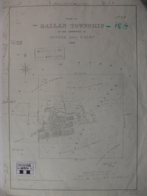 Ballan Shire Historical Society
Map - Map. Ballan Township, Plan of Ballan Township in the Counties of Bourke and Grant
... Plan of Ballan Township in the Counties of Bourke and Grant....The map is an early one of the township of Ballan showing street names and land owners....A map showing the township and surrounding area of Ballan in 1856. ...Map Map. Ballan Township. ...The map is an early one of the township of Ballan showing street names and land owners.The map is significant in that it lists the owners of the house blocks within the township.A map showing the township and surrounding area of Ballan in 1856. Town streets are named as are the owners of the subdivided blocks of land. The map is a lithocopy and there is a scale in chains."D D Fraser" is written across the top of the map and "1856" is written in the near top right corner. There are other additions to the map but they are very difficult to decipher accurately or completely.ballan, ballan township map, ballan1856 -
![View of the Township of Omeo / [by] Nicholas Caire, circa 1876](/media/collectors/550653872162f11fb04854aa/items/57830e80d0cdd1176c4335ca/item-media/57830eecd0cdd1176c43dd40/item-fit-380x285.jpg?cb=6) Kew Historical Society Inc
Kew Historical Society IncPhotograph, Anglo-Australasian Photographic Company, View of the Township of Omeo, c. 1876
... View of the Township of Omeo...‘View of the township of Omeo’ : Views of Victoria (General Series) No.44 : Albumen silver photograph | Photo on card with Title and Description on reverse | Mounted 24 x 30 cm; Photo 12 x 17 cm....On Reverse: ‘The subject of this illustration is the most remote Township in the Colony of Victoria, being about 250 miles distant from Melbourne. ...View of the Township of Omeo Photograph Photograph Anglo-Australasian Photographic Company ...Nicholas Caire was born on Guernsey in the Channel Islands in 1837. He arrived in Adelaide with his parents in about 1860. In 1867, following photographic journeys in Gippsland, he opened a studio in Adelaide. From 1870 to 1876 he lived and worked in Talbot in Central Victoria. In 1876 he purchased T. F. Chuck's studios in the Royal Arcade Melbourne. In 1885, following the introduction of dry plate photography, he began a series of landscape series, which were commercially successful. As a photographer, he travelled extensively through Victoria, photographing places few of his contemporaries had previously seen. He died in 1918. Reference: Jack Cato, 'Caire, Nicholas John (1837–1918)', Australian Dictionary of Biography.An original, rare photograph from the series 'Views of Victoria: General Series' by the photographer, Nicholas Caire (1837-1918). The series of 60 photographs that comprise the series was issued c. 1876 and reinforced a neo-Romantic view of the Australian landscape to which a growing nationalist movement would respond. Nicholas Caire was active as a photographer in Australia from 1858 until his death in 1918. His vision of the Australian bush and pioneer life had a counterpart in the works of Henry Lawson and other nationalist poets, authors and painters.‘View of the township of Omeo’ : Views of Victoria (General Series) No.44 : Albumen silver photograph | Photo on card with Title and Description on reverse | Mounted 24 x 30 cm; Photo 12 x 17 cm.On Reverse: ‘The subject of this illustration is the most remote Township in the Colony of Victoria, being about 250 miles distant from Melbourne. It is situated on the Australian Alps, near Mt. Livingstone. The bed of the River, which is seen on the right-hand side of the picture, is one of the sources of the Mitchell River, which empties itself in the Gipps Land Lakes. This Township is frequently covered with snow in winter time, owing to its being several thousand feet above the level of the sea.’ nicholas caire (1837-1918), omeo (vic), gippsland, mount livingstone, australian alps -
 Sunbury Family History and Heritage Society Inc.
Photograph, Rosa McCall, Old Broadmeadows Township, 1949
... Old Broadmeadows Township...The former Old Broadmeadows township in the photograph was taken in 1949. ...A print of a non-digital black and white photograph of a small country township with a shop on the RHS and a two storey building in the middle distance. ...The former Old Broadmeadows township in the photograph was taken in 1949. ...The former Old Broadmeadows township in the photograph was taken in 1949. The hotel is the two storey building in the middle distance and the former general store is partly hidden by trees on the RHS. The image is looking to the north in Fawkner Street, across the Moonee Ponds Creek. The township is now part of Westmeadows.Old Broadmeadows Township was an important stopping-off point for travellers on their way to Sydney on the Old Sydney Road, (now Mickleham Road) up until 1869 when Sydney Road was finally opened. A print of a non-digital black and white photograph of a small country township with a shop on the RHS and a two storey building in the middle distance. Pine trees are growing on either side of the roadway.old broadmeadows township, townships, moonee ponds creek, westmeadows -
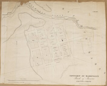 Bacchus Marsh & District Historical Society
Map, Maddingley Township, Parish of Parwan, County of Grant, 1856
... Maddingley Township, Parish of Parwan, County of Grant, 1856...Maddingley is a locality or township within the broader township area of Bacchus Marsh. ...A single page paper map showing land allotments, streets, and natural watercourses in the township of Maddingley. The map is pasted into a bound volume containing 76 maps or plans in total. ...Bacchus Marsh & District Historical Society Lerderderg Library Main Street Bacchus Marsh Maddingley is a locality or township within the broader township area of Bacchus Marsh. ...Maddingley is a locality or township within the broader township area of Bacchus Marsh. This map is dated 1856 but is based on an earlier survey in 1843. The main area of Maddingley shown on this map is an area bounded by Bacchus Street, Moore Street, Griffith Street and Franklin Street. Other streets visible are Inglis Street, Labilliere Street, McCrae Street. The area to the east of Franklin Street is not sub-divided and is described as an 'alluvial flat. A single page paper map showing land allotments, streets, and natural watercourses in the township of Maddingley. The map is pasted into a bound volume containing 76 maps or plans in total. Two inscriptions: 1. A.J. Skene Surveyor, 1843. ; 2. Surveyor-General's Office Melbourne, Sept 6, 1856. (Lithographed by R. Meikle)bacchus marsh victoria maps, maddingley victoria maps, land use, maddingley victoria history -
 Mt Dandenong & District Historical Society Inc.
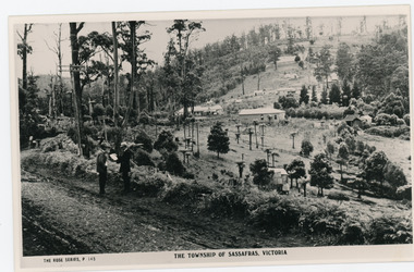
Photograph, The Township of Sassafras. Victoria, late 1940s
... The Township of Sassafras. Victoria...The township of Sassafras taken late 1940s. The man in the foreground in the trilby, carrying the rucksack is a Rose Series employee. ...Behind them is the early township of Sassafras....Behind them is the early township of Sassafras. The Township of Sassafras. ...The township of Sassafras taken late 1940s. The man in the foreground in the trilby, carrying the rucksack is a Rose Series employee. He appears in many of the photos. Sassafras House can be seen in the centre of the picture.Black and white copy of a Rose Series postcard P. 145 showing two men stnding at the side of the road . Behind them is the early township of Sassafras.sassafras -
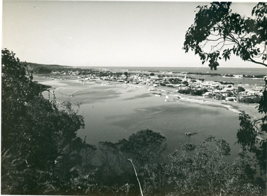 Lakes Entrance Historical Society
Photograph - Township, View from Kalimna Heights overlooking Lakes Entrance Victoria, 1955
... Township...Township...Black and white photograph of a view from Kalimna Heights overlooking township. Shows North Arm, Marine Parade, Cunninghame Arm and sand hummocks with Bass Strait in distance. ...Bulmer copyright. Township Waterways Black and white photograph of a view from Kalimna Heights overlooking township. ...Also black and white postcard, similar view, titled Lakes Entrance through the trees from Lovers Walk. Bulmer copyright.Black and white photograph of a view from Kalimna Heights overlooking township. Shows North Arm, Marine Parade, Cunninghame Arm and sand hummocks with Bass Strait in distance. Lakes Entrance Victoriatownship, waterways -
![View of the Township of Mt. Blackwood / [by] Nicholas Caire, circa 1876](/media/collectors/550653872162f11fb04854aa/items/57830cfbd0cdd1176c424e00/item-media/57830d7ad0cdd1176c428423/item-fit-380x285.jpg?cb=6) Kew Historical Society Inc
Kew Historical Society IncPhotograph, Anglo-Australasian Photographic Company, View of the Township of Mt. Blackwood, c. 1876
... View of the Township of Mt. Blackwood...‘View of the Township of Mt. Blackwood’ : Views of Victoria (General Series) No.42 : Albumen silver photograph | Photo on card with Title and Description on reverse | Mounted 24 x 30 cm; Photo 12 x 17 cm....This scene is characteristic of the wild appearance which many of the inland townships of Victoria represent.’...This scene is characteristic of the wild appearance which many of the inland townships of Victoria represent.’ ‘View of the Township of Mt. ...Nicholas Caire was born on Guernsey in the Channel Islands in 1837. He arrived in Adelaide with his parents in about 1860. In 1867, following photographic journeys in Gippsland, he opened a studio in Adelaide. From 1870 to 1876 he lived and worked in Talbot in Central Victoria. In 1876 he purchased T. F. Chuck's studios in the Royal Arcade Melbourne. In 1885, following the introduction of dry plate photography, he began a series of landscape series, which were commercially successful. As a photographer, he travelled extensively through Victoria, photographing places few of his contemporaries had previously seen. He died in 1918. Reference: Jack Cato, 'Caire, Nicholas John (1837–1918)', Australian Dictionary of Biography.An original, rare photograph from the series 'Views of Victoria: General Series' by the photographer, Nicholas Caire (1837-1918). The series of 60 photographs that comprise the series was issued c. 1876 and reinforced a neo-Romantic view of the Australian landscape to which a growing nationalist movement would respond. Nicholas Caire was active as a photographer in Australia from 1858 until his death in 1918. His vision of the Australian bush and pioneer life had a counterpart in the works of Henry Lawson and other nationalist poets, authors and painters.‘View of the Township of Mt. Blackwood’ : Views of Victoria (General Series) No.42 : Albumen silver photograph | Photo on card with Title and Description on reverse | Mounted 24 x 30 cm; Photo 12 x 17 cm.On Reverse: ‘The locality which this illustration represents was formerly known as the Blackwood Forest, and has been the scene of considerable mining activity. The shallow alluvial diggings of the early days have given place to the deep sinking in search of reefs. This scene is characteristic of the wild appearance which many of the inland townships of Victoria represent.’nicholas caire (1837-1918), blackwood (vic), mount blackwood, landscape photography - victoria -
![View of the Township of Ballan / [by] Nicholas Caire, circa 1876](/media/collectors/550653872162f11fb04854aa/items/578258d3d0cdd1176ce23812/item-media/57825939d0cdd1176ce27694/item-fit-380x285.jpg?cb=6) Kew Historical Society Inc
Kew Historical Society IncPhotograph, Anglo-Australasian Photographic Company, View of the Township of Ballan, c. 1876
... View of the Township of Ballan...‘View of the Township of Ballan’.; Views of Victoria (General Series) No.35; Albumen silver photograph | Photo on card with Title and Description on reverse | Mounted 24 x 30 cm; Photo 12 x 17 cm....On Reverse: ‘The Township of Ballan is situated near the Bullarook Forest, and is distant about twenty miles from Ballarat. ...View of the Township of Ballan Photograph Photograph Anglo-Australasian Photographic Company ...Nicholas Caire was born on Guernsey in the Channel Islands in 1837. He arrived in Adelaide with his parents in about 1860. In 1867, following photographic journeys in Gippsland, he opened a studio in Adelaide. From 1870 to 1876 he lived and worked in Talbot in Central Victoria. In 1876 he purchased T. F. Chuck's studios in the Royal Arcade Melbourne. In 1885, following the introduction of dry plate photography, he began a series of landscape series, which were commercially successful. As a photographer, he travelled extensively through Victoria, photographing places few of his contemporaries had previously seen. He died in 1918. Reference: Jack Cato, 'Caire, Nicholas John (1837–1918)', Australian Dictionary of Biography.An original, rare photograph from the series 'Views of Victoria: General Series' by the photographer, Nicholas Caire (1837-1918). The series of 60 photographs that comprise the series was issued c. 1876 and reinforced a neo-Romantic view of the Australian landscape to which a growing nationalist movement would respond. Nicholas Caire was active as a photographer in Australia from 1858 until his death in 1918. His vision of the Australian bush and pioneer life had a counterpart in the works of Henry Lawson and other nationalist poets, authors and painters.‘View of the Township of Ballan’.; Views of Victoria (General Series) No.35; Albumen silver photograph | Photo on card with Title and Description on reverse | Mounted 24 x 30 cm; Photo 12 x 17 cm.On Reverse: ‘The Township of Ballan is situated near the Bullarook Forest, and is distant about twenty miles from Ballarat. It is chiefly a small agricultural town, but it has become notable of late owing to its Mineral Springs, of which there are several in the neighbourhood. The most important one is owned by Messrs. Joske & Co., who supply the public with this delightful beverage.’ nicholas caire (1837-1918), ballan, bullarook forest, mineral water, ballan mineral springs, post and rail fence -
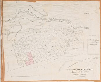 Bacchus Marsh & District Historical Society
Map, Maddingley Township, Parish of Parwan, circa 1890s
... Maddingley Township, Parish of Parwan, circa 1890s...Maddingley is a locality or township within the broader township area of Bacchus Marsh. ...A single page paper map showing land allotments, streets, rivers, creeks, park lands, the railway line and Bacchus Marsh railway station in the township of Maddingley. The map is pasted into a bound volume containing 76 maps or plans in total. ...Bacchus Marsh & District Historical Society Lerderderg Library Main Street Bacchus Marsh Maddingley is a locality or township within the broader township area of Bacchus Marsh. ...Maddingley is a locality or township within the broader township area of Bacchus Marsh. This map is not dated. However features in Maddingley which appeared in the 1880s and 1890s are present in the map, These include the Bacchus Marsh Railway Station and the Bacchus Marsh Showgrounds. The main residential and commercial area of Maddingley is shown on this map in an area bounded by Bacchus Street, Barry Street, Griffith Street and Maddingley Road. Other streets visible are Franklin Street, Inglis Street, Labilliere Street, McCrae Street, Moore Street and part of Station Street.A single page paper map showing land allotments, streets, rivers, creeks, park lands, the railway line and Bacchus Marsh railway station in the township of Maddingley. The map is pasted into a bound volume containing 76 maps or plans in total. bacchus marsh victoria maps, maddingley victoria maps, land use, maddingley victoria history -
Clunes Museum
Map, Township of Clunes - Parish of Clunes - County of Talbot
... Township of Clunes - Parish of Clunes - County of Talbot...Map of Clunes Township in 1951...REFERENCE: G76359 GENERAL FILE TOWNSHIP RESIDENTIAL ALLOTMENTS SCALE 30 CHAINS = 1 INCH...REFERENCE: G76359 GENERAL FILE TOWNSHIP RESIDENTIAL ALLOTMENTS SCALE 30 CHAINS = 1 INCH Township of Clunes - Parish of Clunes - County of Talbot Map MAP ...Map of Clunes Township in 19511 X PHOTOCOPY OF MAP, (COMPRISING A NUMBER OF A4 SHEETS TAPED TOGETHER) SHOWING LOT NUMBERS AND NAMES OF LANDHOLDER. REFERENCE GAZ 1951.1480. SCALE 30 CHAINS = 1 INCH 1 X PHOTOCOPY OF MAP, (COMPRISING A NUMBER OF A4 SHEETS TAPED TOGETHER) SHOWING LOT NUMBERS AND NAMES OF LANDHOLDER. REFERENCE: G76359 GENERAL FILE TOWNSHIP RESIDENTIAL ALLOTMENTS SCALE 30 CHAINS = 1 INCHNOTATED IN PURPLE CRAYON ON SECOND MAP: AS AT LATE 1984 COPY OF MAP FROM LAND TITLES OFFICE BALLARATtownship of clunes map, 1951 -
Stawell Historical Society Inc
Map, Township of Stawell, County of Borung, 1958
... Township of Stawell, County of Borung...Township of Stawell, County of Borung...Stawell Historical Society Inc 46 Longfield St Stawell grampians Stawell Township of Stawell, County of Borung Township of Stawell, County of Borung Map ...Township of Stawell, County of Borungstawell