Showing 1621 items matching townships
-
 Halls Gap & Grampians Historical Society
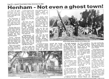
Newspaper - B/W, C 24/11/2000
... TOWNSHIPS ...An article describing the Henham Township project as well as the Knight Family Tearooms built on the Henham site in 1925. For further info see "Victoria's Wonderland" pp 93-95, 103.A newpaper article from "The Stawell Times" , "Halls Gap Extra" Supplement of 24 November 2000, page 16, entitled Henham v- Not even a ghost town!townships, henham -
 Yarra Ranges Regional Museum
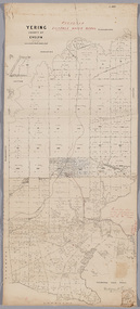
Map, District of Yering, 1 Dec 1885
Canvas backed paper map of District of Yering, Country of Evelyn, showing proposed waterworks for township of Lilydale. Signed by Hodgson & Smith, water supply engineers. Proposed waterworks for the township of Lilydale. Signed by Hodgson & Smith, water supply engineers. Proposed water main shown with of reservoir etc. Canvas backed paper map of District of Yering, Country of Evelyn, showing proposed waterworks for township of Lilydale. Signed by Hodgson & Smith, water supply engineers. Proposed waterworks for the township of Lilydale. Signed by Hodgson & Smith, water supply engineers. Proposed water main shown with of reservoir etc. evelyn, lilydale, waterworks and irrigation -
 Rutherglen Historical Society
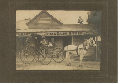
Photograph - Image, 1920s
Black and white photograph, mounted on cardboard, of a horse and cart with the family of the "Stewarts". Photo taken in the early 1920s outside Roger's General Cash Store, Great Northern Township"Early 1920s at Great Northern Township, via Rutherglen. L to R Fanny Stewart, Hector Stewart, Rae Stewart, Myra Stewart."stewart family, fanny stewart, hector stewart, rae stewart, myra stewart, rogers store, general cash store, great northern township -
 Kiewa Valley Historical Society
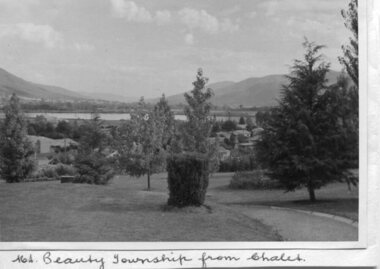
Photos - Mt Beauty and Surrounds, March 1960
Photos of the Kiewa Hydro Scheme and townships as they were in March 1960Pictorial record of the Hydro Electric Scheme in the 1960's when it was operated by the State Electricity Commission of Victoria (SECV). With the privatisation of the SECV in the 1990's the scheme passed to Southern Hydro and was then acquired by ALG Energy in 2005.4 black and white photographs of the Kiewa Valley area taken on a tour of the Kiewa Hydro Electric Scheme in March 1960 1. Mt Beauty township taken from the Mt Beauty Chalet 2. Mt Bogong, taken from Tawonga Gap 3. McKay portal pipeline 4. Bogong townshipmt beauty, kiewa hydro electric scheme, bogong, secv -
 Ringwood and District Historical Society
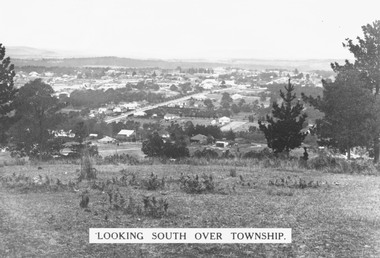
Photograph, Looking south over Ringwood township from Loughnans Hill c1930. Ringwood Street is the main road in the centre
Black and white photograph taken from hill overlooking township of Ringwood. (3 copies)Printed on photograph, "Looking south over township". Typed below photograph, "View from Loughnans Hill c1930. Ringwood Street is the main road in the centre. Old St. Pauls, railway crossing, Methodist church, state school, coolstores, etc. can all be seen". -
 Marysville & District Historical Society
Photograph (item) - Black and white photograph, Valentine Publishing Co. Pty. Ltd, Camberville Township, Near Marysville. V. 35, 1923-1963
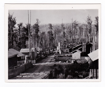
An early black and white photograph of the township of Cambarville near Marysville in Victoria.An early black and white photograph of the township of Cambarville near Marysville in Victoria. Cambarville is notable for its giant mountain ash (Eucalyptus regnans) trees within the Cumberland Memorial Scenic Reserve, and relics from former sawmills and gold mining. The Big Culvert is located nearby on the Marysville-Woods Point Road, which was historically part of the Yarra Track. Cambarville was established as a timber mill town in the 1940s. Timber mill owners A Cameron and FJ Barton named Cambarville. They established the mill to salvage timber from trees destroyed in the 1939 bushfires. Cambarville was impacted by the 2009 Black Saturday bushfires and any remaining structures were destroyed. This photograph was produced by Valentine Publishing Co as a souvenir of Marysville.marysville, victoria, photograph, valentine publishing co, souvenir, cambarville, cumberland valley, cumberland scenic reserve, big culvert, marysville-wood's point road, yarra track, a cameron, fj barton, 1939 bushfires, 2009 black saturday bushfires -
 Marysville & District Historical Society
Photograph (item) - Black and white photograph, Valentine Publishing Co. Pty. Ltd, Camberville Township, Near Marysville. V. 35, 1923-1963
An early black and white photograph of the township of Cambarville near Marysville in Victoria.An early black and white photograph of the township of Camberville near Marysville in Victoria. Cambarville is notable for its giant mountain ash (Eucalyptus regnans) trees within the Cumberland Memorial Scenic Reserve, and relics from former sawmills and gold mining. The Big Culvert is located nearby on the Marysville-Woods Point Road, which was historically part of the Yarra Track. Cambarville was established as a timber mill town in the 1940s. Timber mill owners A Cameron and FJ Barton named Cambarville. They established the mill to salvage timber from trees destroyed in the 1939 bushfires. Cambarville was impacted by the 2009 Black Saturday bushfires and any remaining structures were destroyed. This photograph was produced by Valentine Publishing Co as a souvenir of Marysville.marysville, victoria, photograph, valentine publishing co, souvenir, cambarville, cumberland valley, cumberland scenic reserve, big culvert, marysville-wood's point road, yarra track, a cameron, fj barton, 1939 bushfires, 2009 black saturday bushfires -
 Orbost & District Historical Society
black and white photographs, C 1960s - 1970s
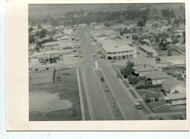
3290.1 is an aerial photograph of the township of Orbost looking south along Nicholson Street. The tennis courts and recreation reserve are on the left. The War Memorial, Commonwealth Hotel at the Saisbury Street intersection is in the centre of the photograph. 3290.2 is an aerial view of the Orbost township looking north, showing the bridge across the Snowy River in the foreground,These photographs are detailed pictorial records of the Orbost township C 1960s - 1970s.Two photographs which are aerial views of a township showing streets, buildings and vehicles. 3290.1 is a black / white photograph. 3290.2 is a coloured photograph.orbost-township-c1960s-1970s aerial-photograph-orbost -
 Orbost & District Historical Society
black and white photograph, February 1971
This photograph is an aerial view of the township of Orbost taken by the Bairnsdale Advertiser newspaper. It was taken from the northern end of the town. The 1971 flood was the the worst flood on record. At Jarrahmond it was at least 11 metres and up to one and a half kilometres wide on the flats causing enormous damage to the flood plain. Records say that "The brown floodwater stain in Bass Strait could be seen from passing airliners." Considerable damage was done to railway infrastructure, roads and farms. More information from the APRIL, 2008 newsletter by John Phillips. (see orbosthistory.com.au)This is a pictorial record of a significant event in the history of Orbost,A black / white aerial photograph of a township with floodwaters in the background.on back - "Note main current through the lagoon 1971."orbost-floods-1971 bairnsdale-advertiser orbost-township -
 Rutherglen Historical Society
Certificate, 1973
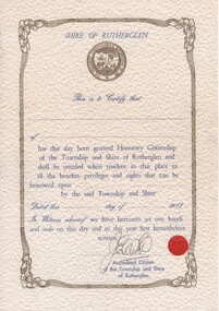
One of the items which would have been presented to a relative of the donor when he was visiting Rutherglen Scotland in 1974.Decorative certificate, printed in blue and gold on textured paper, from the President, Councillors & Ratepayers of the Shire of Rutherglen. Space for the name of the recipient of the "Honorary Citizenship of the Township and Shire of Rutherglen" has been left blank as has the month and day of 1973 for the presentation.At the bottom of the certificate, there is an illegible signature above the words "Accredited Citizen of the Township and Shire of Rutherglen", along with a small red seal. rutherglen scotland, royal burgh of rutherglen -
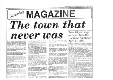 Halls Gap & Grampians Historical Society
Document - Photocopy of article (magazine/newspaper)
... TOWNSHIPS ...Article about the proposed Henham township site and its subsequent failure.Copy of a newspaper article from the Hamilton Spectator, Saturday Magazine, Saturday June 1, 1996.townships, henham, media, newspaper articles -
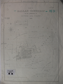 Ballan Shire Historical Society
Map - Map. Ballan Township, Plan of Ballan Township in the Counties of Bourke and Grant
The map is an early one of the township of Ballan showing street names and land owners.The map is significant in that it lists the owners of the house blocks within the township.A map showing the township and surrounding area of Ballan in 1856. Town streets are named as are the owners of the subdivided blocks of land. The map is a lithocopy and there is a scale in chains."D D Fraser" is written across the top of the map and "1856" is written in the near top right corner. There are other additions to the map but they are very difficult to decipher accurately or completely.ballan, ballan township map, ballan1856 -
 Whitehorse Historical Society Inc.
Map, A Plan of part of the Parish of Nunawading, 1984
Hand drawn plan showing the owners or occupiers of land c1860'.Hand drawn plan showing the owners or occupiers of land c1860'. Includes proposed townships of New Brunswick and Norwich. Scate 1 inch : 10 chains.Hand drawn plan showing the owners or occupiers of land c1860'. maps, shire of nunawading -
![View of the township of Golden Square / [by] Nicholas Caire, circa 1876](https://victoriancollections.net.au/media/collectors/550653872162f11fb04854aa/items/578340aed0cdd1176c6899f4/item-media/5783411dd0cdd1176c68c568/item-fit-380x285.jpg) Kew Historical Society Inc
Kew Historical Society IncPhotograph, Anglo-Australasian Photographic Company, View of the township of Golden Square, c. 1876
Nicholas Caire was born on Guernsey in the Channel Islands in 1837. He arrived in Adelaide with his parents in about 1860. In 1867, following photographic journeys in Gippsland, he opened a studio in Adelaide. From 1870 to 1876 he lived and worked in Talbot in Central Victoria. In 1876 he purchased T. F. Chuck's studios in the Royal Arcade Melbourne. In 1885, following the introduction of dry plate photography, he began a series of landscape series, which were commercially successful. As a photographer, he travelled extensively through Victoria, photographing places few of his contemporaries had previously seen. He died in 1918. Reference: Jack Cato, 'Caire, Nicholas John (1837–1918)', Australian Dictionary of Biography.An original, rare photograph from the series 'Views of Victoria: General Series' by the photographer, Nicholas Caire (1837-1918). The 60 photographs that comprise the series were issued c. 1876 and reinforced a neo-Romantic view of the Australian landscape to which a growing nationalist movement would respond. Nicholas Caire was active as a photographer in Australia from 1858 until his death in 1918. His vision of the Australian bush and pioneer life had a counterpart in the works of Henry Lawson and other nationalist poets, authors and painters.‘View of the township of Golden Square’ : Views of Victoria (General Series) No.57 : Albumen silver photograph | Photo on card with Title and Description on reverse | Mounted 24 x 30 cm; Photo 12 x 17 cm.On Reverse: ‘This Township is situated in the Bendigo district, on the road to Castlemaine, and although it is of little importance as a business town, is nevertheless of large importance in consequence of the great number of Quartz Reefs it contains. Almost every house is undermined, and large fortunes have been made by the proprietors. The Church in the distance is that of the Wesleyan body. It was in this township that gold was first discovered in the district of Bendigo.’nicholas caire (1837-1918), golden square (vic), bendigo (vic), gold mining, landscape photography - victoria -
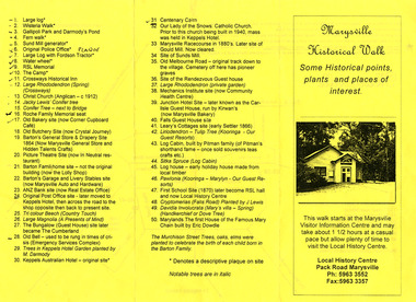 Marysville & District Historical Society
Ephemera (Item) - Information brochure, Marysville & District Historical Society Inc, Marysville Historical Walk, 2003
An information brochure outlining a historical walk around Marysville that takes in some of the more historical sites in the township. This brochure was created by the Marysville & District Historical Society Inc in 2003. Most of the buildings, along with most of the town, were destroyed in the 2009 Black Saturday bushfires.An information brochure outlining a historical walk around Marysville that takes in some of the more historical sites in the township.marysville, victoria, australia, information brochure, 2009 black saturday bushfires -
Whitehorse Historical Society Inc.
Document, What happened to Norwich?
Norwich, consisting of 475 acres in the Parish of Nunawading, County of Bourke, found on a land sale map in the La Trobe collection of Vale maps.Norwich, consisting of 475 acres in the Parish of Nunawading, County of Bourke, found on a land sale map in the La Trobe collection of Vale maps. Research by Jean Uhl into the fate of the proposed township.Norwich, consisting of 475 acres in the Parish of Nunawading, County of Bourke, found on a land sale map in the La Trobe collection of Vale maps. local history, uhl, jean, parish of nunawading, norwich village, vermont, lobb, john, graham, thomas -
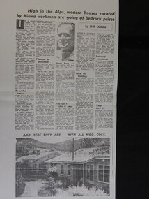 Kiewa Valley Historical Society
Newspaper Article Copy - Sale of Mt Beauty Town, 1960's
Mt Beauty township was sold in the 1960's after the State Electric Commission of Victoria had finished the construction of the Kiewa Hydro Electric Scheme. The sale of Mt Beauty township signified the end of construction of the Kiewa Hydro Electric Scheme and the beginning of Mt Beauty under the Bright Shire (now Alpine Shire). Many of the workers for the State Electricity Commission of Victoria remained in Mt Beauty and many returned to retire in the town in later years.An A3 sized Photocopy of the newspaper article regarding the sale of the Mt Beauty township with a photo of George Rosen and two houses and an A4 newspaper photocopy of the headline newspaper; mt beauty sale; secv; bright shire -
 Orbost & District Historical Society
black and white photograph, late 19th / early 20th century?
This photograph shows a distant view of the Orbost township taken from Grandview Lookout at Newmerella. It appears to have been taken before the railway line was there.This is a pictorial record of early Orbost.A small black / white photograph of the Orbost township taken from Grandview Lookout , Newmerella. The main road can be seen below with paddocks of crops on both sides.on back - "Distant View, Orbost from Grandview"orbost-township-c19th grandview-lookout orbost-flats-paddocks -
Stawell Historical Society Inc
Photograph, Print of 1870's Lithograph of Stawell, 1870's
View has Artistic Licence probably drawn from an original photograph.Fair print on board backing of view of Stawell from Big HillThe Township of Stawell -
 Stawell Historical Society Inc
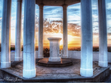
Photograph, Pioneers Memorial on Big Hill -- Sunset through its Columns -- Coloured
Looking through Pioneers Memorial Columns. The photo shows the ground floor of the Pioneers memorial with the Corinthian pillars supporting the dome. The directional pedestal is in the center installed in c 1947. The Stawell township is in the background with the sun setting behind the Grampians.Looking through Pioneers Memorial Columns with the directional pedestal in the center. The view shows the Stawell township in the background and the sun setting behind the Grampians.Carol Anne Jonesstawell -
Whitehorse Historical Society Inc.
Map, Dandenong Ranges Area, 1955
Sheet 13. Parts of Parishes: Nunawading, Mulgrave and Scoresby.Sheet 13. Parts of Parishes: Nunawading, Mulgrave and Scoresby. Includes area of Vermont South marked as proposed Township of Norwich. Scale 10 chains : 1 inch. Contours marked.Sheet 13. Parts of Parishes: Nunawading, Mulgrave and Scoresby. maps, vermont south, wantirna, dandenong creek -
 Mt Dandenong & District Historical Society Inc.
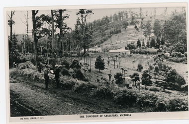
Photograph, The Township of Sassafras. Victoria, late 1940s
The township of Sassafras taken late 1940s. The man in the foreground in the trilby, carrying the rucksack is a Rose Series employee. He appears in many of the photos. Sassafras House can be seen in the centre of the picture.Black and white copy of a Rose Series postcard P. 145 showing two men stnding at the side of the road . Behind them is the early township of Sassafras.sassafras -
 Hume City Civic Collection
Photograph, c late 1980s
The photograph shows a section of the original settlement of the Bulla township. The cutting on the hillside is significant as it is the remains of one of the original stream crossings in Victoria.A coloured photograph of the Bulla Hill along Sunbury Road with a view of the cutting on the distant hillside. The photograph is a view of the old Bulla township looking to the NW. There is a wide grassy verge in the foreground.bulla township, deep creek, wright, william 'tulip', sunbury road, george evans collection -
 Stawell Historical Society Inc
Photograph, Panorama of Stawell from Big Hill -- Sunset -- Coloured
Sunset from Big Hill. The photo shows the Stawell township with the Grampians in the background and the sun setting behind the Grampians. The majority of the image is a view of the cloud formation. Photo taken by Carol Anne JonesColour photograph of sunset from Big Hill. The photo shows the Stawell township with the sun setting behind the Grampians. The majority of the image is a view of the cloud formation.Carol Anne Jonesstawell -
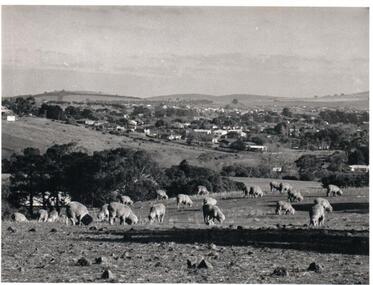 Hume City Civic Collection
Photograph, Early 1970s
The photograph was taken when Sunbury township did not extend far beyond Anderson Road to the west and Powlett Street to the east. The Paynes housing development can be seen scattered across the hillside between Gap Road and Mitchells Lane.A black and white photograph of a panoramic view of Sunbury township looking west and taken from above the Goonawarra Winery. Sheep are grazing on the hilside in the foreground.sunbury township, goonawarra winery, george evans collection -
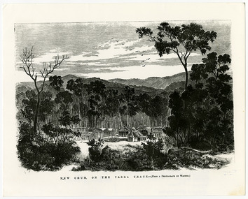 Marysville & District Historical Society
Work on paper (item) - Print of wood engraving, Frederick Grosse et al, New Chum on the Yarra Track, 27-09-1866
A copy of an early wood engraving taken from a photograph of the deserted township of New Chum, near Healesville, on the Yarra Track in Victoria.A copy of an early wood engraving taken from a photograph of the deserted township of New Chum, near Healesville, on the Yarra Track in Victoria. The Yarra Track is the former name of the gold fields road from Healesville to the Woods Point and Jordan Goldfields in Victoria.new chum, healesville, yarra track, victoria, frederick grosse, albert charles cooke, thomas waters, wood engraving -
![View of the Township of Omeo / [by] Nicholas Caire, circa 1876](https://victoriancollections.net.au/media/collectors/550653872162f11fb04854aa/items/57830e80d0cdd1176c4335ca/item-media/57830eecd0cdd1176c43dd40/item-fit-380x285.jpg) Kew Historical Society Inc
Kew Historical Society IncPhotograph, Anglo-Australasian Photographic Company, View of the Township of Omeo, c. 1876
Nicholas Caire was born on Guernsey in the Channel Islands in 1837. He arrived in Adelaide with his parents in about 1860. In 1867, following photographic journeys in Gippsland, he opened a studio in Adelaide. From 1870 to 1876 he lived and worked in Talbot in Central Victoria. In 1876 he purchased T. F. Chuck's studios in the Royal Arcade Melbourne. In 1885, following the introduction of dry plate photography, he began a series of landscape series, which were commercially successful. As a photographer, he travelled extensively through Victoria, photographing places few of his contemporaries had previously seen. He died in 1918. Reference: Jack Cato, 'Caire, Nicholas John (1837–1918)', Australian Dictionary of Biography.An original, rare photograph from the series 'Views of Victoria: General Series' by the photographer, Nicholas Caire (1837-1918). The series of 60 photographs that comprise the series was issued c. 1876 and reinforced a neo-Romantic view of the Australian landscape to which a growing nationalist movement would respond. Nicholas Caire was active as a photographer in Australia from 1858 until his death in 1918. His vision of the Australian bush and pioneer life had a counterpart in the works of Henry Lawson and other nationalist poets, authors and painters.‘View of the township of Omeo’ : Views of Victoria (General Series) No.44 : Albumen silver photograph | Photo on card with Title and Description on reverse | Mounted 24 x 30 cm; Photo 12 x 17 cm.On Reverse: ‘The subject of this illustration is the most remote Township in the Colony of Victoria, being about 250 miles distant from Melbourne. It is situated on the Australian Alps, near Mt. Livingstone. The bed of the River, which is seen on the right-hand side of the picture, is one of the sources of the Mitchell River, which empties itself in the Gipps Land Lakes. This Township is frequently covered with snow in winter time, owing to its being several thousand feet above the level of the sea.’ nicholas caire (1837-1918), omeo (vic), gippsland, mount livingstone, australian alps -
 Kiewa Valley Historical Society
Photograph - Mt Beauty Camp
The new State Electricity Commission construction camp at the head of the Kiewa Valley was for workmen on the second power station in the project expected to be the most modern and best equipped in Australia… In contrast to the early Kiewa days of horses and canvas tents, the new camp, with its modern amenities, compared favourably with any country town. Administration of the Kiewa Scheme was moved from Tawonga to Mount Beauty in 1946. The first house in Mount Beauty, in Hollonds Street, was occupied by the co-op store manager from November 1946. The new Mess Hall at Mt Beauty was opened with much ceremony in early November 1946. The houses up to Nelse street were erected from 1946 onward and then the township was extended beyond Nelse Street in 1950. The workmen's camp was enlarged in 1950 to the extent of providing accommodation for a total of 1,200.Shows early construction in the town of Mt. Beauty surrounded by hills and farmland, with a snow capped Mt Bogong in the background. Photo was taken in approximately 1950 during the early stages of construction of the Kiewa Hydro-electric SystemBlack and white photograph, mounted on corrugated cardboard. Photograph of Mt Beauty townshipHandwritten on back of photograph in blue pen - Permanent loan from Adrian Campan April 96 057-544043mt beauty camp, secv -
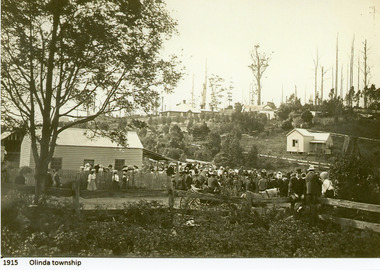 Mt Dandenong & District Historical Society Inc.
Photograph
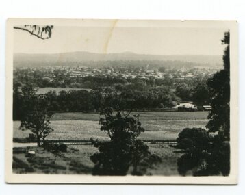
1915 Olinda Township -
 Hume City Civic Collection
Photograph, c 1980s
The photograph although recently taken shows the original settled area in Sunbury, which included Goonawarra Vineyard and Macedon Street which was once the business centre of Sunbury township before the railway was established.A coloured photograph of Sunbury Township looking west from above Jacksons Creek and Goonawarra Winery. Macedon Street can be seen in the middle distance and Mt. Holden and Burke Hill are across the skyline.sunbury township, mt. holden, burke hill, francis, james goodall, barnier, john, jacksons creek, goonawarra winery, george evans collection