Showing 97 items matching "traditional land"
-
 Wonga Park Community Cottage History Group
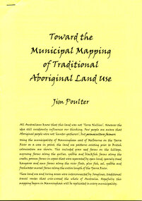
Booklet - 10-page booklet by Jim Poulter, “Toward the Municipal Mapping of Traditional Land Use”
... “Toward the Municipal Mapping of Traditional Land Use”...10-page booklet by Jim Poulter “Toward the Municipal Mapping of Traditional Land Use”...Wonga Park Community Cottage History Group Unit 1, 9 – 13 Old Yarra Road Wonga Park melbourne 10-page booklet by Jim Poulter “Toward the Municipal Mapping of Traditional Land Use” “Toward the Municipal Mapping of Traditional Land Use” Booklet 10-page booklet by Jim Poulter ...10-page booklet by Jim Poulter “Toward the Municipal Mapping of Traditional Land Use” -
 Greensborough Historical Society
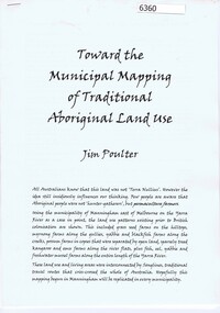
Booklet, Toward the municipal mapping of traditional aboriginal land use, by Jim Poulter, 2017c
... Toward the municipal mapping of traditional aboriginal land use, by Jim Poulter...Greensborough Historical Society 34A Glenauburn Road Lower Plenty Lower Plenty melbourne Using Manningham as an example, aboriginal land use patterns are shown, together with interconnecting songlines. manningham songlines aborigines 10 p., typescript Toward the municipal mapping of traditional aboriginal land use, by Jim Poulter Booklet Jim Poulter ...Using Manningham as an example, aboriginal land use patterns are shown, together with interconnecting songlines.10 p., typescriptmanningham, songlines, aborigines -
 The Beechworth Burke Museum
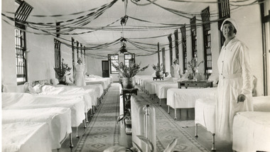
Photograph, 1934
... ...traditional land...The Hospital lies on the traditional land of the Kulin Nation. ...The Hospital lies on the traditional land of the Kulin Nation. This photograph is historically significant as it provides an insight into the living conditions of patients admitted to the Mayday Hills Hospital at the beginning of the 20th century. ...The photo is taken in 1934 and illustrates the internal view of a ward in the Mental Hospital at Beechworth. Some patients in beds and three nurses are in view. Beds were arranged in lines alongside the walls and there were no partitions or screens to create privacy for patients. Furniture was simple and humble; bed frames were made of metal or wood and pillowcases and covers for the attendant`s tables were sometimes made of blue-striped canvas or calico. Large windows in the walls were offering ample light and the room was well-tended, with Christmas decoration, flowers, pots and carpets on the floor. The nurse in the foreground is Miss Neary. The Mayday Hills Hospital was constructed between 1864 and 1867, with buildings created in a number of periods. It formally opened on 24 October 1867 and, along with the Ovens Hospital and the Benevolent Asylum, made Beechworth a prominent social welfare centre in Victoria. The need for an institution of this kind was arisen due to the increased number of people with mental disturbances (induced by the harsh living conditions on the goldfields) and the remoteness of the district from Melbourne. The site was chosen for its panoramic view of the countryside, the hilltop atmosphere and the native fauna, all contributing to the cure of patients. The Hospital was originally named the “Ovens Lunatic Asylum” but, during the centenary celebrations in 1967, the name was officially changed to “Mayday Hills Hospital”, showing the gradual shift in the perception and understanding of mental health conditions over the last decades. The Hospital lies on the traditional land of the Kulin Nation. This photograph is historically significant as it provides an insight into the living conditions of patients admitted to the Mayday Hills Hospital at the beginning of the 20th century. It also contributes to the understanding of the district`s development and its importance to the course of Victoria`s history. Additionally, it provides important information about the way mental health conditions were perceived at that time and how patients were treated. Black and white rectangular photograph printed on paper. Reverse: 1997.2665/ To Miss JA.Peach/ [hallmark: Printed by Harringtons]/ With best wishes/from/H.Jeanes/for 1934.mayday hills hospital, benevolent asylum, ovens hospital, ovens lunatic asylum, kulin nation, beechworth, patients, nurse, social welfare, goldfields, melbourne, mental health, living conditions, blue-striped canvas, calico, bed frames, miss neary, mental disturbances, traditional land, centenary celebrations -
 Kiewa Valley Historical Society
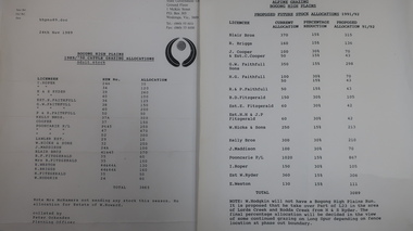
Papers - Cattle Grazing, Bogong High Plains
... In the 1990s government departments allocated the number of cattle being taken up to the Bogong High Plains by the families who traditionally leased land there....In the 1990s government departments allocated the number of cattle being taken up to the Bogong High Plains by the families who traditionally leased land there. Cattle grazing had been banned in other Alpine areas due to concerns of their impact on the environment. ...Cattle grazing. In the 1990s government departments allocated the number of cattle being taken up to the Bogong High Plains by the families who traditionally leased land there.Cattle grazing had been banned in other Alpine areas due to concerns of their impact on the environment. Kiewa Valley cattle graziers were caught up in the controversy as it was their tradition dating back to the 1840s. This controversy continues as cattle grazing was banned in 2005. 4 pages with black print: 1. 1989/90 Cattle Grazing Allocation and Dept. of Conservation Forests and Lands, Wodonga. 2. Proposed Future Stock Allocations 1991/92 list of 16 families 3. & 4. List of families, ear marks, brands etc. dated 22nd Feb. 1979 stapled togetherex S.C.A. / Benalla / Received 22nd Feb. 1979 / signedcattle grazing, kiewa valley farmers -
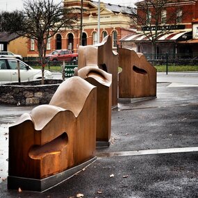 City of Ballarat
Artwork, other - Public Artwork, Cliff Burtt, Buninyong Bivium, 2016
... The town of Buninyong is dominated by the profiles of Mt Helen and the extinct volcano Mt. Buninyong. Traditional land of the Wadawurrung people, today the area remains a significant site for the culture of indigenous people and their connection to the land. ...The town of Buninyong is dominated by the profiles of Mt Helen and the extinct volcano Mt. Buninyong. Traditional land of the Wadawurrung people, today the area remains a significant site for the culture of indigenous people and their connection to the land. ...Buninyong Bivium (2016) by Cliff Burtt engages with the geography and history of the Buninyong region in both pre and post settlement. The town of Buninyong is dominated by the profiles of Mt Helen and the extinct volcano Mt. Buninyong. Traditional land of the Wadawurrung people, today the area remains a significant site for the culture of indigenous people and their connection to the land. The profile of this sculpture is based on topographical mapping of the area, depicting sections of the landscape. The gaps between the elements of the work can be viewed as representations of the shafts sunk into the earth by the early gold miners and compound curves on the upper surfaces are mirroring the topography of the area, while cut-aways in the sides are suggestive of rock strata.The artwork is of aesthetic and social significance to the people of BallaratCorten steel sculpture made of five unique sculptural pieces secured to at concreate base at pavement levelbuninyong, cliff burtt, sculpture, public art, mining, ballarat -
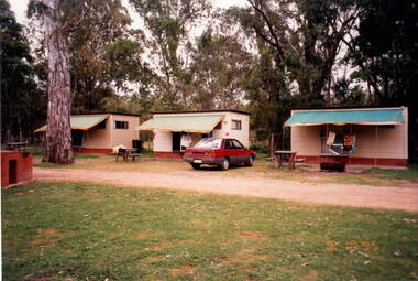 Sunbury Family History and Heritage Society Inc.
Photograph, Bulla Primary School, Hanging Rock, 1995
... Hanging Rock, also known as Mount Diogenes, is the traditional land of the Dja Dja Wurrung, Woi Wurrung and Taungurung people. ...Hanging Rock, also known as Mount Diogenes, is the traditional land of the Dja Dja Wurrung, Woi Wurrung and Taungurung people. ...In 1995, the upper school students from Bulla Primary School attended a camp at Hanging Rock Reserve which is part of the Macedon Ranges. At this camp the students were shown basic rock climbing skills and explored the rock for its interesting geological formations. Hanging Rock, also known as Mount Diogenes, is the traditional land of the Dja Dja Wurrung, Woi Wurrung and Taungurung people. It is a mamelon formed when magma poured from a vent and congealed. There are interesting rock functions at the site such as the Colonnade, the Eagle and the UFO. The highest point on the rock is 718metres above sea level and 105 meters above the land at its base.Hanging Rock is an important geological and volcanic structure in the Macedon Ranges area and in central Victoria. A non-digital coloured photograph of three holiday cabins and a barbecue in a bushland setting. A red car is parked outside one of the cabins as well as two permanent picnic tables.hanging rock, mount diogenes, mamelons, volcanoes, school camps, bulla primary school -
 Port Melbourne Historical & Preservation Society
Photograph - Rockery, newly planted garden area, Port Melbourne Uniting Church, Heather Wale, c. 2002
... One of four photos taken early 2003 of newly planted garden area in front of Port Melbourne Uniting Church, where a 2001 plaque acknowledges the traditional custodians of the land (Wurundjeri and Bunnerwrung peoples): rockery...Port Melbourne Historical & Preservation Society Port Melbourne Town Hall 333 Bay Street Port Melbourne melbourne Indigenous Australians Parks and Gardens Religion - Uniting Church Wurundjeri Bunnerwrung One of four photos taken early 2003 of newly planted garden area in front of Port Melbourne Uniting Church, where a 2001 plaque acknowledges the traditional custodians of the land (Wurundjeri and Bunnerwrung peoples): rockery Photograph Rockery, newly planted garden area, Port Melbourne Uniting Church Heather Wale ...One of four photos taken early 2003 of newly planted garden area in front of Port Melbourne Uniting Church, where a 2001 plaque acknowledges the traditional custodians of the land (Wurundjeri and Bunnerwrung peoples): rockeryindigenous australians, parks and gardens, religion - uniting church, wurundjeri, bunnerwrung -
Port Melbourne Historical & Preservation Society
Photograph - Plaque, newly planted garden area, Port Melbourne Uniting Church, Heather Wale, c. 2002
... One of four photos taken early 2003 of newly planted garden area in front of Port Melbourne Uniting Church, where a 2001 plaque acknowledges the traditional custodians of the land (Wurundjeri and Bunnerwrung peoples): plaque...Port Melbourne Historical & Preservation Society Port Melbourne Town Hall 333 Bay Street Port Melbourne melbourne Indigenous Australians Parks and Gardens Religion - Uniting Church Wurundjeri Bunnerwrung One of four photos taken early 2003 of newly planted garden area in front of Port Melbourne Uniting Church, where a 2001 plaque acknowledges the traditional custodians of the land (Wurundjeri and Bunnerwrung peoples): plaque Photograph Plaque, newly planted garden area, Port Melbourne Uniting Church Heather Wale ...One of four photos taken early 2003 of newly planted garden area in front of Port Melbourne Uniting Church, where a 2001 plaque acknowledges the traditional custodians of the land (Wurundjeri and Bunnerwrung peoples): plaqueindigenous australians, parks and gardens, religion - uniting church, wurundjeri, bunnerwrung -
Port Melbourne Historical & Preservation Society
Photograph - Rockery, newly planted garden area, Port Melbourne Uniting Church, Heather Wale, c. 2002
... One of four photos taken early 2003 of newly planted garden area in front of Port Melbourne Uniting Church, where a 2001 plaque acknowledges the traditional custodians of the land (Wurundjeri and Bunnerwrung peoples): rockery, close-up...Port Melbourne Historical & Preservation Society Port Melbourne Town Hall 333 Bay Street Port Melbourne melbourne Indigenous Australians Parks and Gardens Religion - Uniting Church Wurundjeri Bunnerwrung One of four photos taken early 2003 of newly planted garden area in front of Port Melbourne Uniting Church, where a 2001 plaque acknowledges the traditional custodians of the land (Wurundjeri and Bunnerwrung peoples): rockery, close-up Photograph Rockery, newly planted garden area, Port Melbourne Uniting Church Heather Wale ...One of four photos taken early 2003 of newly planted garden area in front of Port Melbourne Uniting Church, where a 2001 plaque acknowledges the traditional custodians of the land (Wurundjeri and Bunnerwrung peoples): rockery, close-upindigenous australians, parks and gardens, religion - uniting church, wurundjeri, bunnerwrung -
Port Melbourne Historical & Preservation Society
Photograph - Plaque, newly planted garden area, Port Melbourne Uniting Church, Heather Wale, c. 2002
... One of four photos taken early 2003 of newly planted garden area in front of Port Melbourne Uniting Church, where a 2001 plaque acknowledges the traditional custodians of the land (Wurundjeri and Bunnerwrung peoples): plaque close-up...Port Melbourne Historical & Preservation Society Port Melbourne Town Hall 333 Bay Street Port Melbourne melbourne Indigenous Australians Parks and Gardens Religion - Uniting Church Wurundjeri Bunnerwrung One of four photos taken early 2003 of newly planted garden area in front of Port Melbourne Uniting Church, where a 2001 plaque acknowledges the traditional custodians of the land (Wurundjeri and Bunnerwrung peoples): plaque close-up Photograph Plaque, newly planted garden area, Port Melbourne Uniting Church Heather Wale ...One of four photos taken early 2003 of newly planted garden area in front of Port Melbourne Uniting Church, where a 2001 plaque acknowledges the traditional custodians of the land (Wurundjeri and Bunnerwrung peoples): plaque close-upindigenous australians, parks and gardens, religion - uniting church, wurundjeri, bunnerwrung -
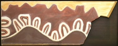 Burrinja Cultural Centre
Aboriginal painting - Paddy Jampin Jaminji, Paddy Jaminji, The Hills of Bedford Station, pre 1995
... In around 1924 a band of Gija people crossed fences onto their traditional land near Bedford Downs Station in the East Kimberley 2000 km northeast of Perth and killed nine head of cattle. ...Burrinja Cultural Centre Cnr Glenfern Rd and Matson Dr Upwey melbourne In around 1924 a band of Gija people crossed fences onto their traditional land near Bedford Downs Station in the East Kimberley 2000 km northeast of Perth and killed nine head of cattle. ...In around 1924 a band of Gija people crossed fences onto their traditional land near Bedford Downs Station in the East Kimberley 2000 km northeast of Perth and killed nine head of cattle. This act precipitated one of the massacres to become known as the 'killing times'. Paddy Quilty, the station owner of Bedford Downs had his men collect wagon loads of firewood which was distributed around the camp. He then invited everyone to assemble for their rations. The food, laced with strychnine, was handed out. As the Gija people fell down dying in agony, they were shot. The firewood was used to burn the bodies. One boy escaped to the the story. Paddy Jamin Jaminji (c.1922-1997) painted The Hills of Bedford Downs Station as part of a series of painting about the Killing Times. It depicts the story and sites of the massacre. At least twelve killing sites are recorded within a radius of 150 km of Turkey Creek, WA. The painting was possibly discarded due to its damage in one corner and later collected from an old shelter at Warmun on a field trip by collector Neil McLeod in 1995.Large painting on board of symbolic landscape. Brown, yellow, cream and white. Framed.bedford downs station, massacre, killing, gija, paddy quilty, turkey creek, warmun -
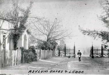 The Beechworth Burke Museum
Photograph - Photograph Reproduction, 1890
... The Hospital lies on the traditional land of the Kulin Nation....The Hospital lies on the traditional land of the Kulin Nation. This photograph is historically significant as it provides an insight into the location, surroundings and the exterior of the Mayday Hills Hospital at the end of the 19th century. ...The photo is taken in 1890 and a man is depicted, entering the main gates of the Mental Hospital at Beechworth, with the lodge on his right side. The man is dressed according to the australian fashion of that time, wearing a dark suit and a top hat. The countryside surrounding the Hospital is in the background. The Mayday Hills Hospital was constructed between 1864 and 1867, with buildings created in a number of periods. It formally opened on 24 October 1867 and, along with the Ovens Hospital and the Benevolent Asylum, made Beechworth a prominent social welfare centre in Victoria. The need for an institution of this kind was arisen due to the increased number of people with mental disturbances (induced by the harsh living conditions on the goldfields) and the remoteness of the district from Melbourne. The site was chosen for its panoramic view of the countryside, the hilltop atmosphere and the native fauna, all contributing to the cure of patients. It was designed in Italianate style and around 250 workmen were employed for its construction. The Hospital was originally named the “Ovens Lunatic Asylum” but, during the centenary celebrations in 1967, the name was officially changed to “Mayday Hills Hospital”, showing the gradual shift in the perception and understanding of mental health conditions over the last decades. The Hospital lies on the traditional land of the Kulin Nation.This photograph is historically significant as it provides an insight into the location, surroundings and the exterior of the Mayday Hills Hospital at the end of the 19th century. It also contributes to the understanding of the district`s development and its importance to the course of Victoria`s history. Moreover, it adds information to the scientific research and the way mental health conditions were treated at that time.Black and white rectangular photograph printed on paper unframed.Obverse: Asylum Gates & Lodge/ Reverse: 3451-1/mental hospital, beechworth, australian fashion, dark suit, top hat, countryside, mayday hills hospital, ovens hospital, benevolent asylum, institution, mental disturbances, social welfare, living conditions, goldfields, workmen, italianate style, kulin nation, mental health, ovens lunatic asylum, patients -
 Federation University Art Collection
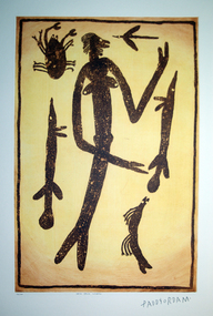
Work on paper - Artwork - printmaking, Lytlewode Press, A suite of limited edition prints by Paddy Fordham Wainburranga, 2003, 2003
... Paddy was part of the movement for equal rights for all Aborigines, actively involved in claiming Bumdibu as his traditional land for his clan. He resided over this land as Jungai (caretaker, policeman). ...Paddy was part of the movement for equal rights for all Aborigines, actively involved in claiming Bumdibu as his traditional land for his clan. He resided over this land as Jungai (caretaker, policeman). ...Paddy Fordham Wainburranga (1932-2006) Area: Arnhem Land Country: Bamdibu (Bumdubu) near Bulman Station As a child, Paddy grew up in Maningrida an Aboriginal community on the top end of the Northern Territory. He started working as a boy around cattle yards, which finally led him to working as a stockman for 20 years. Before this, he spent much of his time hunting and learning culture and customs from his father and uncles. He could remember being taken to a sacred location where he was told many Dreamtime stories of how customs came to be and why Aboriginal people practice them. Paddy was part of the movement for equal rights for all Aborigines, actively involved in claiming Bumdibu as his traditional land for his clan. He resided over this land as Jungai (caretaker, policeman). Paddy was taught to paint by his father but did not begin to paint seriously until the early 1970s. He was also recognized as a story teller, bark painter, sculpture, dancer, singer and musician. He was familiar with Central Arnhem Land rock and bark painting traditions; however he developed an idiosyncratic style which fused the figurative schema of western Arnhem Land with the narrative capacities of the north-east producing dense pictorial paintings divided into sequential segments. A suite of seven limited edition prints using the sugar lift aquatint technique. .1) Yalk Yalk Woman Sugar Lift Aquatint Plate 75.0cm (H) x 49.0cm (W) Paper 1110cm (H) x 76.0cm (W) 2003 Edition: 73/100 .2) Walga Walga Sugar Lift Aquatint Plate 75.0cm (H) x 49.0cm (W) Paper 1110cm (H) x 76.0cm (W) 2003 Edition: 73/100 .3) Nammooroddoo Sugar Lift Aquatint Plate 75.0cm (H) x 49.0cm (W) Paper 1110cm (H) x 76.0cm (W) 2003 Edition: 73/100 Nammooroddoo Sugar Lift Aquatint Plate 75.0cm (H) x 49.0cm (W) Paper 1110cm (H) x 76.0cm (W) 2003 Edition: 73/100 .3) Nammooroddoo Sugar Lift Aquatint Plate 75.0cm (H) x 49.0cm (W) Paper 1110cm (H) x 76.0cm (W) 2003 Edition: 73/100 .4) Mun Gruk Gruk Woman Sugar Lift Aquatint Plate 75.0cm (H) x 49.0cm (W) Paper 1110cm (H) x 76.0cm (W) 2003 Edition: 73/100 .5 Mun Gruk Gruk Man Sugar Lift Aquatint Plate 75.0cm (H) x 49.0cm (W) Paper 1110cm (H) x 76.0cm (W) 2003 Edition: 73/100 .6) Mun Gruk Gruk Sugar Lift Aquatint Plate 75.0cm (H) x 49.0cm (W) Paper 1110cm (H) x 76.0cm (W) 2003 Edition: 73/100 .7) Lightning Man Sugar Lift Aquatint Plate 75.0cm (H) x 49.0cm (W) Paper 1110cm (H) x 76.0cm (W) 2003 Edition: 73/100 Donated through the Australian Government Cultural Gifts Programme by Katherine N. Littlewood, 2014artist, artwork, paddy fordham wainburranga, paddy fordham, wainburranga, printmaking, aboriginal, indigenous, churchill, dreaming -
 The Beechworth Burke Museum
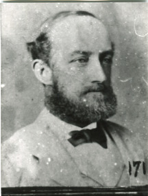
Photograph - Photograph Reproduction, 1870
... The Hospital lies on the traditional land of the Kulin Nation....The Hospital lies on the traditional land of the Kulin Nation. This photograph is historically significant as it provides information about the staff served at the Mayday Hills Hospital when it first opened. ...The photograph is a copy of the original one, with the latter been captured in 1870. The man depicted is Doctor Thomas Thomson Dick, who was the first Medical Superintendent at Mayday Hills Hospital. He was born in Scotland in 1840 and he died in East Malvern in 1919. He obtained his degree of Doctor of Medicine from Melbourne University in 1864 and, later in his career, he became Inspector-General of the mentally ill. Dr Dick promoted the hospital`s self-sufficiency by engaging patients in various forms of work, such as clothing alterations and cultivation of the farm. He also introduced monthly balls, which could be attended by patients, staff and guests, and they were later replaced by concerts. The Mayday Hills Hospital was constructed between 1864 and 1867, with buildings created in a number of periods. It formally opened on 24 October 1867 and, along with the Ovens Hospital and the Benevolent Asylum, made Beechworth a prominent social welfare centre in Victoria. The need for an institution of this kind was arisen due to the increased number of people with mental disturbances (induced by the harsh living conditions on the goldfields) and the remoteness of the district from Melbourne. The site was chosen for its panoramic view of the countryside, the hilltop atmosphere and the native fauna, all contributing to the cure of patients.The Hospital was originally named the “Ovens Lunatic Asylum” but, during the centenary celebrations in 1967, the name was officially changed to “Mayday Hills Hospital”, showing the gradual shift in the perception and understanding of mental health conditions over the last decades. The Hospital lies on the traditional land of the Kulin Nation.This photograph is historically significant as it provides information about the staff served at the Mayday Hills Hospital when it first opened. It also contributes to the understanding of the district`s development and its importance to the course of Victoria`s history and adds valuable information about the changing approaches to the treatment of mental health conditions.Black and white rectangular photograph printed on paper.Obverse: (7)/ Reverse: 1997.2452/ Dr Dick/No(7) Pioneer Board/doctor thomas thomson dick, superintendent, mayday hills hospital, scotland, east malvern, doctor of medicine, melbourne university, inspector-general, clothing alterations, cultivation of the farm, self-sufficiency, balls, concerts, ovens hospital, benevolent asylum, beechworth, goldfields, kulin nation, panoramic view, mental health conditions -
 The Beechworth Burke Museum
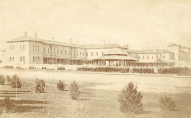
Photograph, Bayless C. - Manager, 1875
... The Hospital lies on the traditional land of the Kulin Nation....The Hospital lies on the traditional land of the Kulin Nation. This photograph is historically significant as it provides an insight into the location, surroundings and the exterior of the Mayday Hills Hospital at the end of the 19th century. ...In this photo, taken in around 1875, is depicted the exterior of the Beechworth Mental Asylum buildings, with the administration buildings far right of the photo. A sunken boundary wall in the foreground and some people in view, sitting at the pavillion in the centre of the image. The two-storey buildings, designed in Italianate style, and the three-storey towers at the front, influenced by the asylum at Colney Hatch in England. The architecture of the buildings shares key features with other contemporary institutions, like Aradale at Ararat, and its design is attributed to the Public Works Department architect, J.J. Clark, whose name is connected with the construction of many other important public buildings, such as the Asylums at Kew and Ararat, the front block of the Royal Mint, Melbourne and the Melbourne Customs House. The Mayday Hills Hospital was constructed between 1864 and 1867, with buildings created in a number of periods. It formally opened on 24 October 1867 and, along with the Ovens Hospital and the Benevolent Asylum, made Beechworth a prominent social welfare centre in Victoria. Large masses of granite were excavated for its foundation and around 250 workmen were employed for its construction. The building, divided into six sections, was comprised of dormitories, doctors` rooms and plenty ancillary rooms and facilities, such as laundries, reading rooms, a concert hall and cooking areas. The site was chosen for its panoramic view of the countryside, the hilltop atmosphere and the native fauna, all contributing to the cure of patients. The Hospital was originally named the “Ovens Lunatic Asylum” but during the centenary celebrations in 1967 the name was officially changed to “Mayday Hills Hospital”, showing the gradual shift in the perception and understanding of mental health conditions over the last decades. The Hospital lies on the traditional land of the Kulin Nation.This photograph is historically significant as it provides an insight into the location, surroundings and the exterior of the Mayday Hills Hospital at the end of the 19th century. It also contributes to the understanding of the district`s development and its importance to the course of Victoria`s history and is acknowledged as a unique construction, being one of three identified as the largest of their kind.Black and white rectangular photograph printed on matte photographic paper mounted on board.Reverse: 37/ 3443/ Beechworth Asylum about 1875/ American & Australasian/Photographic Company/Victoria Branch./C.Bayless, Manager./ No./beechworth mental asylum, aradale, public works department, j.j. clark, melbourne customs house, colney hatch, italianate style, mayday hills hospital, royal mint, granite, benevolent asylum, dormitories, ovens lunatic asylum, ancillary rooms, centenary celebrations, three-storey towers, countryside, mental health conditions, kulin nation, concert hall -
 The Beechworth Burke Museum
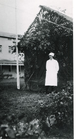
Photograph - Photograph Reproduction, 1998
... The Hospital lies on the traditional land of the Kulin Nation....The Hospital lies on the traditional land of the Kulin Nation. This photograph is historically significant as it provides an insight into the everyday life of staff living within the walls of the Mayday Hills Hospital. ...The photograph, created in 1998, is a copy of the original one, depicting a nurse in uniform at the Mental Hospital in Beechworth, with a fern house behind her. In the background, the two-storey building is in view, along with the covered walkway. The institution had to operate with serious shortage of female nurses for long periods of time. During the 1880s, small houses (cottages) were built to offer accommodation for the nurses living in the hospital and in 1937 began the construction of a nurses` hostel. In 1962 the upper level of the Nurses` Home was converted into a Nurses` Training School. The Mayday Hills Hospital was constructed between 1864 and 1867, with buildings created in a number of periods. It formally opened on 24 October 1867 and, along with the Ovens Hospital and the Benevolent Asylum, made Beechworth a prominent social welfare centre in Victoria. The need for an institution of this kind was arisen due to the increased number of people with mental disturbances (induced by the harsh living conditions on the goldfields) and the remoteness of the district from Melbourne. The two-storey buildings, designed in Italianate style, and the three-storey towers at the front, were influenced by the asylum at Colney Hatch in England. Large masses of granite were excavated for its foundation and around 250 workmen were employed for its construction. The building, divided into six sections, was comprised of dormitories, doctors` rooms and plenty ancillary rooms and facilities, such as laundries, reading rooms, a concert hall and cooking areas. The site was chosen for its panoramic view of the countryside, the hilltop atmosphere and the native fauna, all contributing to the cure of patients. The Hospital was originally named the “Ovens Lunatic Asylum” but, during the centenary celebrations in 1967, the name was officially changed to “Mayday Hills Hospital”, showing the gradual shift in the perception and understanding of mental health conditions over the last decades. The Hospital lies on the traditional land of the Kulin Nation.This photograph is historically significant as it provides an insight into the everyday life of staff living within the walls of the Mayday Hills Hospital. It also offers important information about the location and the exterior of the Hospital and contributes to the understanding of the district`s development and its importance to the course of Victoria`s history.Black and white rectangular photograph printed on paper unframed.Reverse: 3445/mental hospital, beechworth, fern house, female nurses, nurses` home, nurses` training school, nurses` hostel, mayday hills hospital, ovens hospital, colney hatch, two-storey buildings, italianate style, benevolent asylum, ovens lunatic asylum, kulin nation, workmen, covered walkway, granite, hilltop atmosphere, mental health -
 Bendigo Historical Society Inc.
Book - "Snippets of Bendigo History", 2006
... The Bendigo region is the traditional land of the Dja Dja Wurrung (Djaara) people, who have lived in the area for thousands of years. ...The Bendigo region is the traditional land of the Dja Dja Wurrung (Djaara) people, who have lived in the area for thousands of years. ...Edith Lunn was born in Bendigo in July, 1907, and had lived all of her life in the city and its immediate environs. Edith was awarded the Order of Australia medal in 2002 for her services to, and interest in, Bendigo's history. This text records to history of Bendigo, as recalled and researched by Edith. Bendigo, formerly known as Sandhurst, grew from Indigenous lands to a major gold rush boomtown and is now a vibrant regional city with rich cultural heritage. The Bendigo region is the traditional land of the Dja Dja Wurrung (Djaara) people, who have lived in the area for thousands of years. They managed the land sustainably, utilizing the rich hunting grounds and waterways, and their cultural stories and knowledge remain deeply woven into the landscape today. European exploration began with Major Thomas Mitchell in 1836, followed by squatters establishing sheep runs in 1837. The arrival of settlers led to the displacement of the Dja Dja Wurrung people, with waves of settlement from the south in 1837 and from the north in 1845. Gold was discovered on Bendigo Creek in 1851 by Mrs. Margaret Kennedy and Mrs. Julia Farrell, sparking one of Australia’s largest gold rushes. By 1852, around 20,000 people had arrived from across the world, including Europe and China, transforming Bendigo into a booming gold-mining economy. The city was officially named Sandhurst from 1853 to 1891. The wealth generated during this period is reflected in Bendigo’s Victorian architecture, including the Town Hall and historic buildings. Gold mining continued into the early 20th century, but by 1954, mining had largely ceased. The city then shifted focus to manufacturing and regional services, experiencing renewed growth from the 1930s onward. Modern Bendigo has become a fast-growing regional centre, aided by infrastructure like the Calder Freeway linking it to Melbourne. Today, Bendigo preserves its history through museums, walking tours, and heritage sites. Key attractions include the Bendigo Art Gallery, Bendigo Joss House Temple, Central Deborah Gold Mine, and the Goldfields Track, which highlight both the gold rush era and the city’s cultural diversity. "Snippets of Bendigo History" written by Edith Lunn. Forward by Daryl McClure. Printed by Bendigo Modern Press. Soft cover book. Front and back covers are sepia with Bendigo street scene, and front cover has three inset sepia toned Bendigo scenes inserted. Title and author's name are in black text on front cover. Author's name and book title written in black on spine. Printed in Bendigo, Australia. 65 pp. This edition was 500 copies. Contents page on iv. Details about author on iii. Contains both text and black and white images. edith lunn, bendigo -
 Eltham District Historical Society Inc
Film - Video (VHS), Dynavision Video Production, 1994 Eltham Festival, 11 Nov 1994
... John Graves and representatives of the Wurrundjeri, traditional land owners of the area....John Graves and representatives of the Wurrundjeri, traditional land owners of the area. 1st eltham brownies 1st eltham venturers 2nd eltham sea scouts 2nd eltham venturers 3rd eltham brownies 1994 aerial photographs alistair knox park arthur street australian democrats briar hill primary school circus chaos country fire authority diamond valley people for disarmament diamond valley railway eltham community health centre eltham district horse and pony club eltham east primary school eltham festival eltham fire brigade eltham junior football club (panthers) eltham little theatre eltham lower park eltham north primary school eltham people's choir eltham playhouse co-op eltham pre-school eltham roller skating club eltham south pre-school centre eltham steam and stationary engine society grand parade greenhills neighbourhood house heidelberg municipal band hurstbridge learning co-op jock read jocklebeary farm john graves kangaroo ground primary school learning co-op primary school lofty (horse) lower plenty primary school main road matlock police (tv show) montmorency gardening club montmorency south primary school nicholaus lauder estate north warrandyte fire brigade plenty valley 88.6 fm research pre-school research primary school ron sampson salvation army band (briar hill) sherbourne primary school shire of eltham state emergency service (eltham) video recording woodridge pre-school VHS Video cassette (poor quality) Converted to MP4 file format 45:01, 535MB DVD copy of VHS cassette (better quality) 1994 Eltham Festival Film Video (VHS) Dynavision Video Production ...20th Eltham Community Festival and last under the auspices of the Shire of Eltham. The Grand Parade focussing on the theme "Echoes of Eltham - Celebrating the visions of Eltrham from the past and into the future" was headed by Jock Read on his horse Lofty who had been filmed in an Anzac Day Parade on an earlier horse which had featured in the television show Matlock. The parade travelled north along Main Street to just past the Post Office then back south to Panther Place. Parade participants included 1st Eltham Brownies, 1st Eltham Venturers, 2nd Eltham Sea Scouts, 2nd Eltham Venturers, 3rd Eltham Brownies, Australian Democrats, Briar Hill Primary School, Circus Chaos, Country Fire Authority, Diamond Valley People for Disarmament, Diamond Valley Railway, Eltham Community Health Centre, Eltham District Horse and Pony Club, Eltham East Primary School, Eltham Fire Brigade, Eltham Junior Football Club (Panthers), Eltham Little Theatre, Eltham North Primary School, Eltham Playhouse Co-op, Eltham Pre-school, Eltham Roller Skating Club, Eltham South Pre-School Centre, Eltham Steam and Stationary Engine Society, Greenhills Neighbourhood House, Heidelberg Municipal Band, Hurstbridge Learning Co-op, Jocklebeary Farm, Kangaroo Ground Primary School, Learning Co-op Primary School, Lower Plenty Primary School, Main Road, Montmorency Gardening Club, Montmorency South Primary School, North Warrandyte Fire Brigade, Plenty Valley 88.6 FM, Research Pre-school, Research Primary School, Ron Sampson, Salvation Army Band (Briar Hill), Sherbourne Primary School, Shire of Eltham, State Emergency Service (Eltham) and Woodridge Pre-school. The parade commentary was provided by Plenty Valley FM 88.6 with guest commentator, Shire President Cr. John Graves. Following the parade is video footage from a helicopter of Alistair Knox Park, displays along Main Road and activities in Alistair Knox Park and the Rugby oval along with stationary engines, helicopter joyrides, Eltham People's Choir, music entertainment. Scenes also from the Diamond Valley Railway at Eltham Lower Park and finishing with the fireworks display. At the end of the video is a promotional video for Dynavision Video Production, a local video production company that produced the video and Diamond Photos (Kodak Express). One of the highlights of the festival was a tree planting ceremony in Alistair Knox Park to celebrate 123 years of the Shire of Eltham led by Shire President Cr. John Graves and representatives of the Wurrundjeri, traditional land owners of the area.VHS Video cassette (poor quality) Converted to MP4 file format 45:01, 535MB DVD copy of VHS cassette (better quality)1st eltham brownies, 1st eltham venturers, 2nd eltham sea scouts, 2nd eltham venturers, 3rd eltham brownies, 1994, aerial photographs, alistair knox park, arthur street, australian democrats, briar hill primary school, circus chaos, country fire authority, diamond valley people for disarmament, diamond valley railway, eltham community health centre, eltham district horse and pony club, eltham east primary school, eltham festival, eltham fire brigade, eltham junior football club (panthers), eltham little theatre, eltham lower park, eltham north primary school, eltham people's choir, eltham playhouse co-op, eltham pre-school, eltham roller skating club, eltham south pre-school centre, eltham steam and stationary engine society, grand parade, greenhills neighbourhood house, heidelberg municipal band, hurstbridge learning co-op, jock read, jocklebeary farm, john graves, kangaroo ground primary school, learning co-op primary school, lofty (horse), lower plenty primary school, main road, matlock police (tv show), montmorency gardening club, montmorency south primary school, nicholaus lauder estate, north warrandyte fire brigade, plenty valley 88.6 fm, research pre-school, research primary school, ron sampson, salvation army band (briar hill), sherbourne primary school, shire of eltham, state emergency service (eltham), video recording, woodridge pre-school -
 Federation University Historical Collection
Flag - Australian Flag, Red Australian Flag
... The Red Ensign was the only flag private citizens could fly on land. By traditional British understanding, the Blue Ensign was reserved for Commonwealth Government use, with State and local governments, private organisations and individuals all using the Red Ensign....The Red Ensign was the only flag private citizens could fly on land. By traditional British understanding, the Blue Ensign was reserved for Commonwealth Government use, with State and local governments, private organisations and individuals all using the Red Ensign. ...The Australian Red Ensign is a variant flag of Australia. This flag was probably used for a patriotic purpose in Ballarat, such as the end of World War One. The Red Ensign was the only flag private citizens could fly on land. By traditional British understanding, the Blue Ensign was reserved for Commonwealth Government use, with State and local governments, private organisations and individuals all using the Red Ensign.(http://en.wikipedia.org/wiki/Flag_of_Australia) There was some confusion over appropriate use of the ensigns until the Flags Act 1953 set the Blue Ensign as the national flag, and the Red Ensign as the flag of the Australian mercantile marine. Red ensigns continued to be used in Anzac Day marches into the 1960s.(http://en.wikipedia.org/wiki/Flag_of_Australia) Small red paper Australian flag attached to a stick. The Red Ensign features the Commonwealth Star at the hoist, and the Southern Cross in the other half.ballarat, flag, australian ensign, world war, australian flag, red ensign -
Bialik College
Flyer (item) - Ngarrgee, 2020
... Invitations sent to school community and running sheets for Ngarrgee events 2020- to acknowledge the traditional owners of the land, Rosh Hashanah, and to welcome the new Year 12 leadership cohort, the Mazkirut. ...Bialik College 429 Auburn Road Hawthorn East 3123 melbourne Invitations sent to school community and running sheets for Ngarrgee events 2020- to acknowledge the traditional owners of the land, Rosh Hashanah, and to welcome the new Year 12 leadership cohort, the Mazkirut. ...Invitations sent to school community and running sheets for Ngarrgee events 2020- to acknowledge the traditional owners of the land, Rosh Hashanah, and to welcome the new Year 12 leadership cohort, the Mazkirut. 'Ngarrgee' is a Wurundjeri word meaning 'coming together'. The school's RAP Committee advised in 2020: 'Following on from the very successful Welcome to Country smoking ceremony in 2019, which was appropriately aligned with Rosh Hashanah, we are continuing with this new tradition by hosting the same event on Tuesday 15 September at 8.00pm via the ZOOM platform. Adapting to current circumstances, the smoking ceremony will be led by Murrundindi, Ngurungaeta (Head Man) for the Wurundjeri clan, from his property in Healesville. This year, the event will also incorporate the Mazkirut Induction ceremony.' Please contact [email protected] to request access to this record. event, celebration, year 12, 2020s -
 Melbourne Water
Photograph, North Cocoroc State Primary School, 1950s
... The name 'Cocoroc' means 'frog' in the language of the Wathaurung people — the Traditional Owners of the land the treatment plant was built on. ...The name 'Cocoroc' means 'frog' in the language of the Wathaurung people — the Traditional Owners of the land the treatment plant was built on. ...As the Yarra became unsuitable as a source of water, several attempts were made to find alternative sources for the growing population of Melbourne. It was not until 1891 that the efforts to sewer Melbourne came to fruition with the setting up of the Melbourne Metropolitan Board of Works (MMBW), now known as Melbourne Water. From 1891 until 1992, it was the responsibility of the MMBW to safeguard public health by providing a sewerage system and a safe water supply system. In 1992, The MMBW merged with a number of smaller urban water authorities to form Melbourne Water. The township of Cocoroc was created in 1894 at the Metropolitan Sewage Farm (now the Western Treatment Plant) to house the workers it employed. The name 'Cocoroc' means 'frog' in the language of the Wathaurung people — the Traditional Owners of the land the treatment plant was built on. By the early 1950s there were nearly 100 houses, a town hall, football ground (and team), swimming pool, tennis courts, four schools and a post office, and by the 1970s some 500 people were living in Cocoroc. As it became too expensive for the MMBW to subsidise, Cocoroc was abandoned. By 1973 most of the houses and other buildings were demolished or moved to Werribee. All that is left now of Cocoroc are two small, empty, concrete swimming pools, a few weatherboard sheds and a big iron water tank. This photograph detailing an exterior view of the North Cocoroc State Primary School, is historically significant as it captures children at play within a purpose built community. The School that was one of four was built to educate the children of the MMBW workers. As the school no longer exists, this photograph is the only tangible evidence left of the building, also showcasing the style of buildings in this era. cocoroc, township, school, mmbw, melbourne metropolitan board of works, melbourne water -
 Federation University Historical Collection
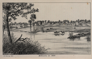
Image, John Helder Wedge, Melbourne in 1838, 1938
... The people of the Kulin nation are the traditional owners of the land that became Melbourne — including the Boonwurrung, Woiwurrung, Taungurung and Djadjawurrung people, who gathered in this place for ceremonies and cultural activities. ...The people of the Kulin nation are the traditional owners of the land that became Melbourne — including the Boonwurrung, Woiwurrung, Taungurung and Djadjawurrung people, who gathered in this place for ceremonies and cultural activities. ...The following information is from http://melbourneday.com.au/about.html, accessed 30 August 2016 Melbourne was founded on 30 August 1835 by settlers who sailed from Van Diemen’s Land (Tasmania) aboard the schooner Enterprize. They landed on the north bank of the Yarra River and established the first permanent settlement, close to where the Immigration Museum at the Old Customs House — on the corner of William and Flinders Streets — stands and the place today known as Enterprize Park. Melbourne Day Committee was established to help correct the record about the founding of Melbourne and celebrate its anniversaries. The settlers came from Launceston in search of sheep-grazing land. Land had become expensive and there had long been stories told by whalers and sealers working in Bass Strait of fertile land to the north. This was the southern part of the colony of New South Wales, which the Colonial Government did not want settled at that time. After the Henty family crossed Bass Strait and settled at Portland in 1834 others quickly followed. The north bank was chosen because a small waterfall, or rapids, stopped further progress up the river. The waterfall also separated the tidal movement, providing a vital supply of fresh water. The site had previously been noted by the colony of New South Wales' surveyor, Charles Grimes, in 1803. The north bank also offered more stable, suitable ground. The people of the Kulin nation are the traditional owners of the land that became Melbourne — including the Boonwurrung, Woiwurrung, Taungurung and Djadjawurrung people, who gathered in this place for ceremonies and cultural activities. The topsail schooner Enterprize you see today is a full-size replica of the one that brought the settlers and has become a symbol of Melbourne Day. Her keel was laid at Polly Woodside Maritime Museum in 1991, and the $2.5 million, 27m vessel was launched by Felicity Kennett on 30 August, 1997, at Hobsons Bay. The original ship was bought by John Pascoe Fawkner in April 1835 specifically to search for a suitable place for a settlement in the Port Phillip District. After helping establish Melbourne, the original Enterprize continued operating as a coastal trading vessel for a number of years. She eventually disappeared off the shipping register in 1847, having been wrecked on a sand bar in the Richmond River in northern NSW, with the loss of two lives. The replica is managed by the Enterprize Ship Trust, a not-for-profit organisation. The first settlers were those on board the Enterprize — her crew and passengers. They were John Lancey , master mariner and Fawkner’s representative; Enterprize's captain, Peter Hunter; George Evans, plasterer/builder; carpenters William Jackson and Robert Hay Marr; Evan Evans, George Evans’ servant; and Fawkner’s servants ploughman Charles Wise, general servant Thomas Morgan, blacksmith James Gilbert and his pregnant wife, Mary. And Mary's cat! Enterprize set sail on her historic voyage from Launceston on July 21, 1835, stopping at George Town in northern Tasmania where creditors detained Fawkner. He was therefore not part of the first trip to Melbourne. Enterprize then left on August 1 under the command of captain Hunter. The expedition was led by Lancey, Fawkner's delegate. The party first considered Western Port and the eastern side of Port Phillip for a place to settle, before deciding on the Yarra’s north bank — known today as Enterprize Park. On Sunday, August 30, they disembarked and began to erect shelter, build a store and clear land to grow food, thus starting the permanent European settlement of Melbourne.Image of the fledgling town of Melbourne on the banks of the Yarra River. melbourne, yarra river, john helder wedge -
 Federation University Historical Collection
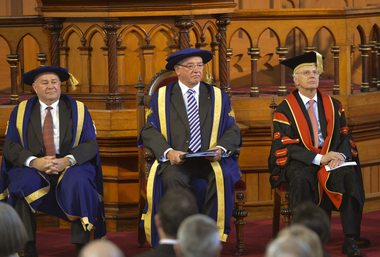
Photograph - Photograph - Colour, Installation of University of Ballarat Chancellor Paul Hemming, 2012, 17/0/2012
... At the installation of Dr Hemming as the Fifth Chancellor Of The University Of Ballarat Governor of Victoria Alex Chrnov said: "I join Bonnie Fagan in acknowledging the traditional owners of this land and I pay my respects to their elders past and present. ...At the installation of Dr Hemming as the Fifth Chancellor Of The University Of Ballarat Governor of Victoria Alex Chrnov said: "I join Bonnie Fagan in acknowledging the traditional owners of this land and I pay my respects to their elders past and present. ...In April 2012 former Royal Australian College of General Practitioners president Dr Paul Hemming was appointed the University of Ballarat’s new chancellor. Dr Hemming was a deputy chancellor of the university since 2011 and a member of the university council since 2007, and replaces outgoing chancellor Robert Smith. He was a founding director of Beyondblue and has been president of the Royal Australian College of General Practitioners. He was also president of the Australian Medical Association Victoria and has served on numerous federal government medical bodies and tribunals. Chancellors are appointed to chair the university's council (governing body) as the senior office holder of the University. They also confer the academic awards of the university, and represent the university at meetings, functions and ceremonies. At the installation of Dr Hemming as the Fifth Chancellor Of The University Of Ballarat Governor of Victoria Alex Chrnov said: "I join Bonnie Fagan in acknowledging the traditional owners of this land and I pay my respects to their elders past and present. It is my great pleasure, as Governor of Victoria and Visitor to the University of Ballarat, to install Dr Paul Hemming as the fifth Chancellor of this University. I extend to him and his family my warmest congratulations on this appointment and wish him all the best in his new role. I have no doubt that he will be an industrious and wise leader of this University. Although the University of Ballarat is one of Australia’s newest Universities, it is the third oldest Tertiary institution in our country with the School of Mines being established in 1870. It has much to be proud of, and should be recognised for its commitment to being one of our most outstanding regionally focused higher education institutions. It offers on six campuses a diverse, yet suitably targeted, group of learning models that include higher education, TAFE and senior secondary school education, and is one of the few universities in the country that has an associated Technology Park. This University is uniquely placed to provide higher education in Regional Victoria. For example, I understand that by 2020 the population in the Ballarat area will increase by 20% so this University will have the responsibility and opportunity to provide educational opportunities for this growing population. The role of the Governor can be divided into three parts – ceremonial, constitutional and community engagement. It is the third aspect of the role that is most time consuming and, I add, enjoyable. It includes making official visits to Regional areas of Victoria. To date Elizabeth and I have been on 16 such visits and the thing that stands out is that despite the challenges that face Regional communities whether it be through natural disasters, or the economy more broadly – the stoicism, volunteerism and self reliance are always present. Ballarat is an example of such resilience and confidence in its future that can be dated back to this University’s inception. When the School of Mines was established in 1870 on the back of the gold rush era of the 1850s, the local community had vision and faith in its future that is reflected in the building of this institution. It is not dissimilar to Melbourne, where its relatively few citizens established the iconic pillars of our society like the State Library, the University of Melbourne, Parliament Houses and the National Gallery of Victoria. The contribution by the University of Ballarat to Regional Victoria cannot be overstated. Not only does it provide top educational opportunities for students from the Region but its graduates almost invariably end up working in Regional Australia, and often in their own local communities. More specifically, almost three out of every four of the graduates from this University end up finding employment in Regional areas. Such figures highlight the University’s significant contribution to the Regional economy. But its impact is not limited to our Regional areas – it extends to other parts of Australia and overseas. But like so many other higher education institutions in Australia, the University of Ballarat is facing challenges brought about by events such as global uncertainties and the high Australian dollar that impact on the inflow of international students, and dealing with students, more and more of whom come from the lower socio economic sector. It is in those circumstances that the Chancellor must show leadership that involves, amongst others, objectively guiding the Council and supporting the Vice-Chancellor, albeit without becoming involved in the day to day micro management of the University. A strong, trusting and respectful working relationship between the Chancellor and the Vice-Chancellor is, I believe, critical to the sound progress of a University. Before I turn more specifically to Dr Hemming, I would like to reflect briefly on his immediate predecessor, Emeritus Professor Robert Smith. I am sure that Dr Hemming has already found in Professor Smith an invaluable source of assistance. He was a skilled and effective leader not only here, but also in the broader higher education sector. I mention by way of example his instigation and leadership two years ago of the much acclaimed Chancellors’ Conference that was held in Melbourne. There was great diffidence amongst the Chancellors in having it at all. It was a little like herding cats. But Bob Smith spearheaded the organisation of it, with great attention to detail. And it was his hard work and leadership that resulted in the Conference being such a success and of assistance to all Chancellors who attended. It was an illustration of Bob Smith’s skills as a leader in the sector and of this University. And the sector, just as this University remains indebted to him. And I have no doubt that Dr Hemming will similarly lead this University through the challenging, yet exciting, times that lie ahead. He is eminently qualified to do so, in terms of his personal attributes, academic achievements and experience in governance. With his extensive medical career as a General Practitioner, service on a number of Federal Government medical boards and tribunals, and having been a Founding Director of ‘Beyondblue’, President of the Royal Australian College of General Practitioners and President of the Australian Medical Association (Victoria), his list of personal and professional achievements, as well as his strong sense of public and community duty, is impressive. Importantly, Dr Hemming has a long standing connection with the Ballarat community, having moved here with his family from the United Kingdom in 1977. He is now even accepted as a “local” I am told. Given his range of experience to which I have referred and the time he has already spent on the Council and Standing Committees of this University, he is obviously well placed to take part in leading this University. So it is a great pleasure for me to install Dr Hemming as the fifth Chancellor of the University of Ballarat." (http://www.governor.vic.gov.au/victorias-governor/publications/speeches/speech/speech/104) Colour photographS of three men in academic regalia sitting inside the Ballarat Uniting Church, Lydiard Street South. Chancellor Dr Paul Hemming sit in the centre, with Vice-Chancellor Professor david Battersby on the left. Also audience images, academics and a dinner at Craig's Hotel.university of ballarat, federation university, regalia, chancellor, vice chancellor, paul hemming, david battersby, alex chrnov, todd walker, andy smith, craig's hotel, academics -
 Warrnambool and District Historical Society Inc.
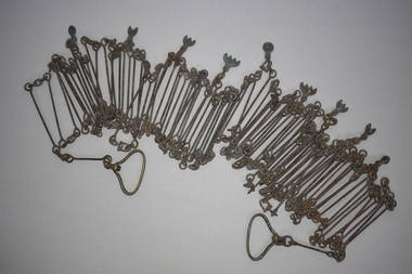
Chain link measure, Gunter's Chain, 19th Century
... land surveying instrument, is named after its inventor, Edmund Gunter (1581-1626), an English mathematician and astronomer. It was first produced in 1620. The tool has 100 links and is 66 feet or one chain long. The links are marked off in groups of ten by metal tags or rings. A quarter chain (25 links) is called a rod or pole and ten chains make a furlong and 80 chains a mile. The traditional...land surveying instrument, is named after its inventor, Edmund Gunter (1581-1626), an English mathematician and astronomer. It was first produced in 1620. The tool has 100 links and is 66 feet or one chain long. The links are marked off in groups of ten by metal tags or rings. A quarter chain (25 links) is called a rod or pole and ten chains make a furlong and 80 chains a mile. The traditional ...A Gunter’s Chain, an old land surveying instrument, is named after its inventor, Edmund Gunter (1581-1626), an English mathematician and astronomer. It was first produced in 1620. The tool has 100 links and is 66 feet or one chain long. The links are marked off in groups of ten by metal tags or rings. A quarter chain (25 links) is called a rod or pole and ten chains make a furlong and 80 chains a mile. The traditional cricket pitch is 22 yards or one chain long. This chain is said to have been used by Gilbert Nicol when the Warrnambool to Hamilton Road was constructed in the 19th century. Gilbert Nicol was an early settler in Warrnambool who, with John Craig, established the first hotel (and the first building) in Warrnambool in 1847. Nicol later owned the property ‘Rosehill’ in the Warrnambool area. As the chain was given to the Warrnambool and District Historical Society by the Town Clerk, Keith Arnel, it is likely that the chain was one of the items in the old Warrnambool MuseumThis Gunter’s Chain is of importance because it is an early land measuring device that was used for over 250 years and has great historical and mathematical significance. If it is correct that it was used by Gilbert Nicol when the Warrnambool to Hamilton Road was built then it has considerable local significance and dates back to the 19th century. This is a metal tool which consists of 100 metal pieces or links joined together by loops at each end with two metal loops in between each link. The links joined together form a chain. The two ends of the chain have small metal handles attached. At intervals along the chain there are additional rings or metal pieces attached. The metal is very rusted.gunter’s chain, land measurement tools, history of warrnambool -
 Warrnambool and District Historical Society Inc.
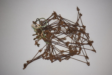
Chain link measure, Gunter, Early 20th century
... land surveying instrument, is named after its inventor, Edmund Gunter (1581-1626), an English mathematician and astronomer. It was first produced in 1620. The tool has 100 links and is 66 feet or one chain long. The links are marked off in groups of ten by metal rings or tags. A quarter chain (25 links) is called a rod or pole and ten chains make a furlong and 80 chains make a mile. The traditional...land surveying instrument, is named after its inventor, Edmund Gunter (1581-1626), an English mathematician and astronomer. It was first produced in 1620. The tool has 100 links and is 66 feet or one chain long. The links are marked off in groups of ten by metal rings or tags. A quarter chain (25 links) is called a rod or pole and ten chains make a furlong and 80 chains make a mile. The traditional ...This Gunter’s Chain, an old land surveying instrument, is named after its inventor, Edmund Gunter (1581-1626), an English mathematician and astronomer. It was first produced in 1620. The tool has 100 links and is 66 feet or one chain long. The links are marked off in groups of ten by metal rings or tags. A quarter chain (25 links) is called a rod or pole and ten chains make a furlong and 80 chains make a mile. The traditional cricket pitch is 22 yards or one chain long. This Gunter’s Chain is of considerable significance because: 1. It is an early land measuring tool that was used for over 250 years and has great historical and mathematical significance. A Gunter’s Chain would have been used when forming and building local roads from the earliest days of settlement. 2. It has a possible local connection as it was given to the Historical Society by a local person in 1965 and possibly came from the property of ‘Rosehill’ This is a metal tool which consists of 100 metal pieces or links joined together by loops at each end with two metal loops in between each link. The links joined together form a chain. The two ends of the chain have small metal handles attached At intervals along the chain there are additional rings or metal pieces attached. Some white and green rope material has been used to bundle up the chain. The metal is somewhat rusted. gunter’s chain, land measurement tools, history of warrnambool -
 Emerald Museum & Nobelius Heritage Park
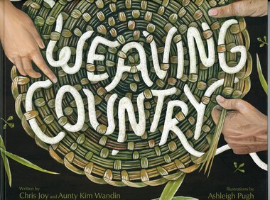
Book, Chris Joy and Aunty Kim Wandin et al, Weaving Country, 2025
... The Wurundjeri Woi-wurrung people are the traditional owners of the land on which the Emerald Museum is situated. ...This is a story about Aunty Kim teaching her granddaughter to weave which includes understanding and caring for Country.Children's book with color illustrations and text. 30 pages.fictionThis is a story about Aunty Kim teaching her granddaughter to weave which includes understanding and caring for Country.wurundjeri woi-wurrung -
Federation University Historical Collection
Book - Book - Scrapbook, Ballarat School of MInes: Scrapbook of Newspaper Cuttings, Book 10, January 1981 to June 1981
... traditional crafts...new plumbing/sheetmetal complex at smb...smb's land...The papers concerned are The Courier, Ballarat, The Australian, The Age over the period of 13/01/1981 to 06/06/1981. staffing advertisements courses available smb to run certificated courses on computers new skills for a new era annette chappell-lawrence adult education programs unemployment takes toll of unskilled in workforce induction program for electrical apprentices at smb business studies upgrade of typewriters smb first country venue for sec distribution officers' training course training of apprentices move for school of traditional crafts new plumbing/sheetmetal complex at smb smb's land laboratory lesley blanchard and nerida smith are commonwealth employment service success stories ballarat city council defers smb request for funds governor-general sir zelman cowan to open founders hall at bcae concern at tafe expectations 'great hall' has strong lines hall achieves all that donors hoped help with spelling problems school transition group ballarat special school mary shone co-ordinator 700 attend opening of founders hall mittagundi outdoor program education mission from china tractor for smb farm course - international harvester andrew hammond peter drake and tim murphy top motor mechanic apprentices stuart harwood and john mitchell win australian welding institute awards financial limits on tafe students build in mud bricks john michell wins engineering prize smb wine appreciation workshop Book with white cover, front, spiral bound. ...Collection of newspaper articles related to Ballarat School Of Mines.They cover activities and advertisements for staff. The papers concerned are The Courier, Ballarat, The Australian, The Age over the period of 13/01/1981 to 06/06/1981.Book with white cover, front, spiral bound. staffing advertisements, courses available, smb to run certificated courses on computers, new skills for a new era, annette chappell-lawrence, adult education programs, unemployment takes toll of unskilled in workforce, induction program for electrical apprentices at smb, business studies upgrade of typewriters, smb first country venue for sec distribution officers' training course, training of apprentices, move for school of traditional crafts, new plumbing/sheetmetal complex at smb, smb's land laboratory, lesley blanchard and nerida smith are commonwealth employment service success stories, ballarat city council defers smb request for funds, governor-general sir zelman cowan to open founders hall at bcae, concern at tafe expectations, 'great hall' has strong lines, hall achieves all that donors hoped, help with spelling problems, school transition group, ballarat special school, mary shone co-ordinator, 700 attend opening of founders hall, mittagundi outdoor program, education mission from china, tractor for smb farm course - international harvester, andrew hammond peter drake and tim murphy top motor mechanic apprentices, stuart harwood and john mitchell win australian welding institute awards, financial limits on tafe, students build in mud bricks, john michell wins engineering prize, smb wine appreciation workshop -
 Orbost & District Historical Society
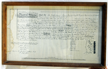
framed document, Batman's Melbourne Deed, 1966
... land around Port Phillip, near the present site of the city of Melbourne. The document came to be known as Batman's Treaty and is considered significant as it was the first and only documented time when Europeans negotiated their presence and occupation of Aboriginal lands directly with the traditional owners. ...The Batman Deed is sometimes called the Batman Treaty, the Dutigullar Deed, the Dutigullar Treaty or the Melbourne Deed. The deeds had been drafted by JT Gellibrand, a leading lawyer in the colony. Batman's Treaty was a document signed on 6 June 1835 by John Batman, an Australian grazier, businessman and explorer, and a group of Wurundjeri elders, for the purchase of land around Port Phillip, near the present site of the city of Melbourne. The document came to be known as Batman's Treaty and is considered significant as it was the first and only documented time when Europeans negotiated their presence and occupation of Aboriginal lands directly with the traditional owners. The so-called treaty was implicitly declared void on 26 August 1835 by the Governor of New South Wales, Richard Bourke. The original Batman Deed is of enormous significance to the history of the European settlement of Victoria. Framed print of the Batman Deed, dated 1835. This is a printed copy of the Batman Deed, made in 1966 from the 'original' by the State Library of Victoria. The frame is wood. The document consists of handwritten text in black ink with eight signatures in the lower right hand side and three signatures in the lower left hand corner. It has been signed by John Batman beneath the eight signatures.document batman-deed melbourne -
 Eltham District Historical Society Inc
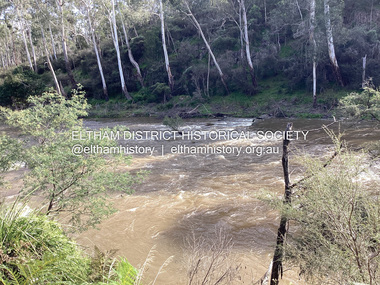
Photograph, Fay Bridge, Ancient Eel trap on the Yarra River at Laughing Waters, Eltham - pre-dating European settlement, 6 September 2023
... land for millennia. The site on the Yarra River near the former Morrison property Killeavey was given a language name in 2015 at the instigation of Wurundjeri Elder, Dave Wandin. Garambi Baan means “laughing waters” in the traditional...land for millennia. The site on the Yarra River near the former Morrison property Killeavey was given a language name in 2015 at the instigation of Wurundjeri Elder, Dave Wandin. Garambi Baan means “laughing waters” in the traditional ...Laughing Waters is the name for a stretch of the Yarra Valley Parklands consisting of river flats and hilly riparian bushland. With Birrarung (Yarra River) flowing through, Laughing Waters has been an important gathering place for thousands of years. For the Wurundjeri, ‘Garambi Baan’ (the name for Laughing Waters in Woi wurrung) is an important site for growing and harvesting food. Significantly, Wurundjeri iuk (eel) traps remain at Garambi Baan to this day. The Wurundjeri Woi Wurrung People take their name from the Woi wurrung language word ‘wurun’ meaning the Manna Gum (Eucalyptus viminalis) which is common along ‘Birrarung’ (Yarra River), and ‘djeri’, the grub which is found in or near the tree. Wurundjeri are the ‘Manna Gum People’ and their Ancestors have lived on this land for millennia. The site on the Yarra River near the former Morrison property Killeavey was given a language name in 2015 at the instigation of Wurundjeri Elder, Dave Wandin. Garambi Baan means “laughing waters” in the traditional language, Woi wurrung. The site at Warrandyte was rediscovered by Campbell Beardsell OAM in 2007 and is one of only a few known remaining iuk (eel) traps on Country once found the length of the Birrarung (Yarra) and the Maribyrnong. Original Indigenous aquacultural infrastructure was dismantled, taken away from sites and used to build houses, fords and roads by Europeans. The difficult and restricted access to this site is thought to be one of the reasons for its survival. The iuk trap is located within lands managed by Parks Victoria. The Narrap team in partnership with Parks Victoria and Acacia Land Management have been improving the native vegetation with a program of woody weed removal, exclusion fencing and revegetation. Importantly, the team have restored the trap’s infrastructure and have demonstrated its effectiveness.” References: Wurundjeri Woi Wurrung Cultural Heritage Aboriginal Corporation - Laughing Waters. (2023, September 3). Retrieved from https://inplace.org.au/laughing-waters/ GARAMBI BAAN LAUGHING WATERS RESIDENCY CENTRE 2020 2024 Strategic Plan, Nillumbik Shire Council (2023, September 3). Retrieved from https://www.nillumbik.vic.gov.au/files/assets/public/minutes-and-agendas/2020/09-sep/15-sep-cm/ocm.177-20-attachment-1-laughing-waters-arts-program_1.pdffay bridge collection, eel trap, laughing waters, yarra river, wurundjeri woi wurrung, garambi baan, 2023-09-06 -
 Eltham District Historical Society Inc
Document - Folder, Jim Connor et al, Eltham Gateway, 1987
... land along Main Road, Eltham extending from the roundabout at Fitzsimons Lane to Dudley Street, Eltham. The gateway was a unique urban area with a strong sense of character that provided a distinctive entrance to the Eltham Town Centre. The intention of this group was to support development that preserved both the natural and historic features of the gateway region. It encouraged development sympathetic to Eltham’s traditional...land along Main Road, Eltham extending from the roundabout at Fitzsimons Lane to Dudley Street, Eltham. The gateway was a unique urban area with a strong sense of character that provided a distinctive entrance to the Eltham Town Centre. The intention of this group was to support development that preserved both the natural and historic features of the gateway region. It encouraged development sympathetic to Eltham’s traditional ...The Eltham Gateway Group (EGG) was established about 1987 by some Eltham residents concerned for the development of the Eltham Gateway, defined as that historically and environmentally sensitive region of land along Main Road, Eltham extending from the roundabout at Fitzsimons Lane to Dudley Street, Eltham. The gateway was a unique urban area with a strong sense of character that provided a distinctive entrance to the Eltham Town Centre. The intention of this group was to support development that preserved both the natural and historic features of the gateway region. It encouraged development sympathetic to Eltham’s traditional association with the arts and natural environment. The group was initiated in response to a planning application in December 1986 to redevelop the then Mobil service station site at 729 Main Road, Eltham on the corner of Brougham Street. This group worked with and encouraged the Eltham Shire Council to consider rezoning to protect the gateway area. A detailed Eltham Gateway Study undertaken by Tract Consultants assisted with the establishment of the Eltham Gateway Zone, the Eltham Gateway Policy and the Eltham Gateway Design and Siting Guidelines. The State Government subsequently agreed to a planning amendment to rezone the land from a Residential Zone C to an Eltham Gateway Zone under the Eltham Planning Scheme. While zoning changes over the years have altered the mix of permitted uses within this area the Eltham Gateway still looks and feels like a predominately residential style precinct, even where non-residential type uses operate. EGG was followed by the establishment of the Eltham Protection Society in about 1989 to respond to community planning issues beyond the area of the Eltham Gateway and in effect took over the role from the EGG. Jim Connor President Eltham District Historical Society 4 July 2022 During 1986/87 I was a community member on the Shire of Eltham’s Community Consultative Committee involved with the Eltham Gateway Study, which led to the establishment of the original Eltham Gateway Zone, under the then Eltham Planning Scheme The Eltham Gateway Group was the pioneer community action group dedicated to protecting the character of the Eltham Gateway. It was succeeded by the Eltham Protection Society. When the Shire of Eltham Offices were demolished by the unelected Commissioners of Nillumbik Shire Council in July/August 1996, significant community upset and protest led to the establishement of the Eltham Gateway Action Group (EGAG) which in present day form has evolved into the Eltham Community Action Group (ECAG) focussing on issues throughout Eltham and not just the Eltham Gatewayeltham community action group, eltham gateway, eltham gateway action group, eltham gateway design and siting guidelines, eltham gateway group (egg), eltham gateway policy, eltham gateway study, eltham gateway zone, eltham planning scheme, eltham protection society, jim connor, michael wilson, rodger dalling, tony mcmanus