Showing 127 items matching "transverse"
-
 Federation University Historical Collection
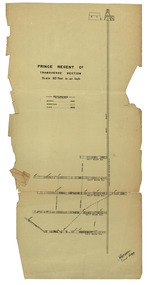
Plan, Prince Regent Co. Transverse Section
... Prince Regent Co. Transverse Section...Transverse section of the Prince Regent Company....Prince Regent Co. Transverse Section Plan ...Transverse section of the Prince Regent Company.prince regent co, foster allan, ernest lidgy, cgt -
 Federation University Historical Collection
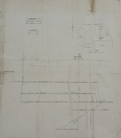
Plan, Llanberris Co. Transverse Section, not dated
... Llanberris Co. Transverse Section...Printed transverse section of the Llanberris Company...Transverse Section Plan Plan ...Printed transverse section of the Llanberris Companyunderground survey, llanberris mine, llanberris co, ballarat -
 Federation University Historical Collection
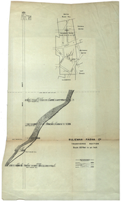
Plan, Sulieman Pasha Co Plan Transverse Section
... Sulieman Pasha Co Plan Transverse Section...A transverse section plan of the Sulieman Pasha Mine....Sulieman Pasha Co Plan Transverse Section Plan Plan ...The Sulieman Pasha is possibly named after the most important Sultan of the Ottoman Empire, Suleiman One, or Suleiman the Magnificent, when the Ottoman Empire was at its peak. Or potentially a number of Ottoman governors, statesmen and military commanders with the same name after, however the spelling is slightly different to the mine name. No Turkish connection was found relating to the formation of the company, and remains unconfirmed. The mine operated from two shafts; No. 1 near the corner of Humffray and Mair streets, and also near where the Welcome Nugget (2217 ounces) was found years earlier; and the controversial No. 2 shaft several blocks south bordering the northern side of the main highway through Ballarat. The company produced 62 666 ounces of gold, the twelfth highest quartz reef gold production for any mine on the Ballarat goldfield. Some crushing figure examples are January-June 1881: 3674 tonnes 1085 ounces; January-June 1885: 2949 tonnes 1281 ounces; July-December 1885: 4459 tonnes 1119 ounces; January-June 1887: 1869 tonnes 730 ounces; July-December 1892: 1450 tonnes 771 ounces; July-December 1896: 4365 tonnes 1372 ounces. Like many mines in the area, gold grades were low. John Watson was noted as mine manager in the 1880s, and John Williams 1890s. The company was re-organised twice increasing the number of shares from 4000 to 24 000, and increasing the capital available. The Sulieman Pasha Company was formed in 1878. David Fitzpatrick was given the honour of turning the first sod of both the No.1 and later No. 2 shafts. The first dividend was given to shareholders in July 1881. The company obtained a prospecting vote (government grant) to start, and was very proud to be the first Victorian gold mining company to pay the funds back to the government. The event was marked by a lavish banquet laid out for ministers and government officials by the company. Leases were purchased to the south in 1885 to the Llanberris Mine boundary, after poor results began accumulating from the small No. 1 shaft. To take advantage of this new land the company planned to sink a second shaft. Initially this was to take place on government land, but the uproar from nearby residents caused the company to purchase land along the Main Road (now Western Highway), and the old Yarrowee Hotel which had occupied the site since the alluvial digger days of the 1850's was demolished. The area had since those days become heavily occupied with a number of shops, houses, a post office, church and two schools in the immediate area. The thought of an underground mine next door drew considerable opposition. The company (before the days of public relations departments) wrote 'most people would have thought that progress as vital as mining would be supported by tradesmen whose business rely on the mining industry. It seems when it comes to mining they are bereft of their senses, and considering the low ebb of mining in Ballarat East, the action of our opponents are unaccountable. (Sarcastically) There are certain engineering difficulties in moving the quartz reefs to a new location, but if we could to appease our opponents we would'. The company also wanted to take over 4 acres of the St Paul's school oval for machinery, but accused the St Paul's Church of wanting extortionate amounts of money upfront, and on a yearly basis for the privilege. It stated the church could not be opposed to mining when several years earlier it had formed its own company to mine the land, only for shareholders to lose their money. In 1886, the company approached the Minister for Mines, and attended heated public meetings on the matter. The local residents, shop owners, and church submitted a 60 person petition to the local council and government authorities. They stated the shaft contravened the mining statutes, which stating no mining could take place within 150 yards of a public building or church. A speech by a resident stated 'mining always comes with glorious pictures of the great benefits which would accrue all parties concerned if their request is granted, but if property is destroyed or depreciated in value, no-one then comes forward and compensates them'. The No. 2 shaft was approved including taking over part of the school oval. In 1888, workers at the company's No. 2 shaft went on strike to try and bring their wages in line with other mines in the district (the No. 1 shaft was operated by tributers). William Madden (26) was killed from a fall of earth underground the same year, while a year later his father John Madden (70) was similarly killed in the Madame Berry Mine elsewhere in the district. In 1897 as the amount of gold being found fell away, it came to light part of the deal to purchase the Yarrowee Hotel site was a 5% royalty on gold found. Shareholders could not understand why they were paying a royalty to the former owners of the property. The mine closed in 1898 due to a lack of gold. In 1902 a boy (age unknown) called Charles Lee was killed from a fractured skull while working to dismantle the Sulieman Pasha plant. The fuss over the No. 2 shaft had a sequel. On the company winding up, the land was purchased by J.S. Trethowan who built a house next to the shaft. In 1907, the shaft caved-in creating a sinkhole immediately at the back of the house. A Mr Chamberlain heard a deep rumbling sound at 5am, and looked out the window to see his fowl house and thirteen chickens disappear down an expanding hole. He then went back to bed, and called the police later in the day. The shaft was 1050 feet deep, and the hole at the surface that developed was 20 feet by 17 feet across, and 20 feet depth. In 1930 it is reported a syndicate had been formed to clean out the old shaft, and re-open the mine. It is assumed this was the No. 1 shaft but no more was found. (https://www.mindat.org/loc-304239.html, accessed 07/08/2019) A transverse section plan of the Sulieman Pasha Mine.sulieman pasha company, plan, mining, united black hill mine, victoria united mine, victoria street, britannia united mine, last chance mine, llanberris mine, ottoman empire, john watson, john williams, david fitzpatrick -
 Sunshine and District Historical Society Incorporated
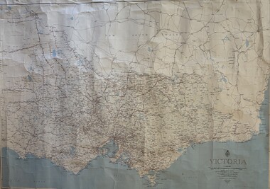
Map - Victoria Transverse Mercator Projection Map, 1967
... Large Victoria Transverse Mercator Projection Map...Victoria Transverse Mercator Projection...Victoria Metropolitan Map Victoria Transverse Mercator Projection Large Victoria Transverse Mercator Projection Map Map Victoria Transverse Mercator Projection Map ...Victoria Transverse Mercator Projectionvictoria metropolitan, map -
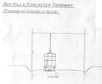 Ballarat Tramway Museum
Document - Photocopy, "Box Hill - Doncaster Tramway, Transverse Section of Road", c1990?
... "Box Hill - Doncaster Tramway, Transverse Section of Road"...Photocopy of a drawing showing the proposed transverse sections of the Box Hill to Doncaster Tramway. ..."Box Hill - Doncaster Tramway, Transverse Section of Road" Document Photocopy ...Photocopy of a drawing showing the proposed transverse sections of the Box Hill to Doncaster Tramway. Drawing prepared at a scale of 4 feet to the inch. Shows the dimensioned sections with the tramcar, poles, sleepers and metal ballast in cutting and in bank (fill). Photocopy larger than original drawing. Has part of a stamp in the lower right hand corner.trams, tramways, box hill, doncaster, plans, sections -
 Greensborough Historical Society
Map, Poulter Avenue transverse, 1900 c
... Poulter Avenue transverse...Includes area of River Estate and part of Poulter Reserve, Carter Street, Flintoff Street and Plenty River. poutlter avenue greensborough Signed by William Haylock Poulter 1 p. photocopy of traverse survey printed in colour Poulter Avenue transverse Map ...This is a survey of land acquired from William Haylock Poulter for the construction of Poulter Avenue. Includes area of River Estate and part of Poulter Reserve, Carter Street, Flintoff Street and Plenty River.1 p. photocopy of traverse survey printed in colourSigned by William Haylock Poulterpoutlter avenue greensborough -
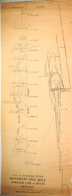 Bendigo Historical Society Inc.
Plan - Monument Hill Gold Mine, 6.11.39
... ...transverse...Detailed transverse plan of Monument Hill Mine, showing main shaft and levels. ...The Monument Hill Gold mine depth was over 1200 ft. gold mining gold Bendigo transverse Monument Hill Gold Mine Detailed transverse plan of Monument Hill Mine, showing main shaft and levels. ...Monument Hill Gold Mine was located near the corner of Old Violet and Olive Streets, Bendigo. It operated until 1947. The shaft was capped, the poppet legs and mullock removed. A house now occupies the site. The Monument Hill Gold mine depth was over 1200 ft. Detailed transverse plan of Monument Hill Mine, showing main shaft and levels. Plan of underground workings alongside section. Written on bottom of plan: 'Plan and transverse section, Monument Hill Mine, Deborah Line of Reefs, Bendigo' Handwritten on bottom of plan: 'J.J. Caldwell, 6.11.39'. Plan forms part of the Margaret Roberts Collection.gold mining, gold, bendigo, transverse, monument hill gold mine -
 Bendigo Historical Society Inc.
Plan - North Argus Company Gold Mine
... ...transverse...Hand drawn plan, in black and red ink, on paper of North Argus Co. workings, showing transverse view of shaft and level at 736 ft. ...North Argus Gold Mine was located near Moon Street, Eaglehawk. gold mining gold Bendigo transverse North Argus Co. Hand drawn plan, in black and red ink, on paper of North Argus Co. workings, showing transverse view of shaft and level at 736 ft. ...North Argus Gold Mine was located near Moon Street, Eaglehawk. Hand drawn plan, in black and red ink, on paper of North Argus Co. workings, showing transverse view of shaft and level at 736 ft. Plan forms part of the Margaret Roberts Collection.gold mining, gold, bendigo, transverse, north argus co. -
 Bendigo Historical Society Inc.
Plan - Monument Hill Gold Mine, 6.11.39
... ...transverse...Transverse section of Monument Hill Mine. Written on top of plan: ' Cross Section Monument Hill Mine'. ...The Monument Hill Gold mine depth was over 1200 ft. gold mining gold Bendigo transverse Monument Hill Gold Mine Transverse section of Monument Hill Mine. ...Monument Hill Gold Mine was located near the corner of Old Violet and Olive Streets, Bendigo. It operated until 1947. The shaft was capped, the poppet legs and mullock removed. A house now occupies the site. The Monument Hill Gold mine depth was over 1200 ft. Transverse section of Monument Hill Mine. Written on top of plan: ' Cross Section Monument Hill Mine'. Handwritten on bottom: ' W.H. Cundy, May 1931' Plan forms part of the Margaret Roberts Collection.gold mining, gold, bendigo, transverse, monument hill gold mine -
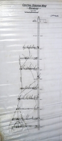 Bendigo Historical Society Inc.
Plan - Central Deborah Gold Mine, 22.10.45
... ...transverse...Transverse section of Central Deborah Gold Mine, Bendigo. ...(Victorian Heritage Database: https://vhd.heritagecouncil.vic.gov.au/places/5996) gold mining gold Bendigo Central Deborah Gold Mine transverse Transverse section of Central Deborah Gold Mine, Bendigo. ...CENTRAL DEBORAH GOLD MINE 76 VIOLET STREET BENDIGO, GREATER BENDIGO CITY: The Central Deborah Gold Mine was developed from 1939 and operated as a working mine until 1954. The mine was one of a minority that continued to function during the Second World War. In 1939 the mine boasted a small timber poppet head, boiler steam winch, compressor, blacksmith shop, store, change rooms, and offices. Between 1945-46 the company upgraded the mine with extensions to sheds and the installation of new steam machinery, electric air compressor, steel poppet head, and ore bins. The Central Deborah Gold Mine is historically significant for its ability to demonstrate the tangible and important links to twentieth century quartz mining. It is of outstanding historical significance as the last intact and working example of the 5,500 quartz mines that won Bendigo widespread fame as a gold mining centre. At one time Bendigo had the world’s deepest shafts. Of particular importance are original buildings, fittings and mining machinery that document the mine’s character from 1939 to 1954. (Criterion A) The Central Deborah Gold Mine is archaeologically significant for its ability and potential to illustrate important aspects of early twentieth century mining. The physical evidence at the site has excellent interpretative value and the ability to answer archaeological research questions. (Criterion C) The Central Deborah Gold Mine is significant as a notable and fine example of the class of twentieth century quartz mine. The working machinery—including a Cornish boiler, winding engine and two compressors—comprise one of the few publicly accessible and in situ collections in the State. Central Deborah Company Gold Mine is now a popular tourist mine and a living part of the story of gold mining in Australia. Its historic mining equipment is still functional, and several levels underground are accessible to visitors. (Victorian Heritage Database: https://vhd.heritagecouncil.vic.gov.au/places/5996) Transverse section of Central Deborah Gold Mine, Bendigo. Printed on top in bold black text: ' Central Deborah Mine Bendigo'. Handwritten on plan: J.Caldwell 12.10.45 Plan forms part of the Margaret Roberts Collection.gold mining, gold, bendigo, central deborah gold mine, transverse -
 Bendigo Historical Society Inc.
Map - South Blue Gold Mine, 8.6.35
... ...transverse...Transverse section of face at 3 and rise in 4, South Blue, written on bottom of plan. ...gold mining gold Bendigo South Blue Gold Mine transverse Transverse section of face at 3 and rise in 4, South Blue, written on bottom of plan. ...Transverse section of face at 3 and rise in 4, South Blue, written on bottom of plan. Plan drawn on cream parchment. Table of information bottom right. Handwritten on bottom plan: Traverse between face at 3 and rise in 4, South Blue 8/6/35. Plan forms part of the Margaret Roberts Collection.gold mining, gold, bendigo, south blue gold mine, transverse -
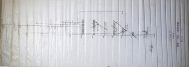
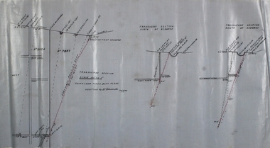
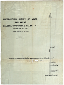 Federation University Historical Collection
Plan, Underground Survey of Mines Ballarat Dalzell-Cum-Prince Regent Co
... Transverse section...mining cgt dalzell-cum-prince plans Transverse section Underground Survey of Mines Ballarat Dalzell-Cum-Prince Regent Co. ...Transverse sectionmining, cgt, dalzell-cum-prince, plans -
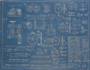 Federation University Historical Collection
Blueprint Plan, Crane Transversing Trolley, 1934-5
... Blueprint plan of a crane-transversing-trolley ...v. hunt plan chambers Crane Tranversing Pulley Blueprint plan of a crane-transversing-trolley Crane Transversing Trolley Blueprint Plan ...Blueprint plan of a crane-transversing-trolley v. hunt, plan, chambers, crane tranversing pulley -
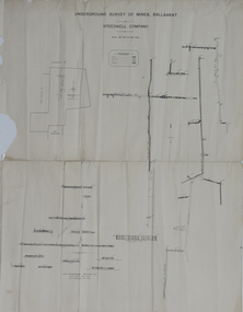 Federation University Historical Collection
Plan, Underground Survey of Mines, Ballaarat, not dated
... Printed transverse section of the Speedwell Company....underground survey speedwell company Printed transverse section of the Speedwell Company. Underground Survey of Mines, Ballaarat Plan Plan ...Printed transverse section of the Speedwell Company.underground survey, speedwell company -
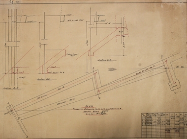
 Federation University Historical Collection
Plan, North Prince Extended Co
... Transverse section of the North Prince Extended Co,...Barker Library (top floor) Mount Helen goldfields north prince extended mining company gold Transverse section of the North Prince Extended Co, North Prince Extended Co, Plan Plan ...Transverse section of the North Prince Extended Co,north prince extended, mining company, gold -
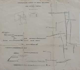 Federation University Historical Collection
Plan, Underground Survey of Mines Ballaarat, New Victoria Company, not dated
... Printed transverse section of the New Victoria Company....underground survey new victoria company transverse section mining plan Printed transverse section of the New Victoria Company. ...Printed transverse section of the New Victoria Company.underground survey, new victoria company, transverse section, mining, plan -
 Bendigo Historical Society Inc.
Plan - W.W. Gully and Footwall
... Transverse section showing W.W. Gully and Phillips Reef. ...Seperate transverse diagrams of north and south of xcut. ...Wattle Gully Gold Mine was at Chewton. A footwall in mining is the underlying rock mass beneath an inclined fault, vein, or mineral deposit. It is named because miners typically walk on this lower surface while the hanging wall lies above them. In mining operations, it serves as a crucial, stable reference point, often housing underground drives and shafts. Transverse section showing W.W. Gully and Phillips Reef. Seperate transverse diagrams of north and south of xcut. Additions by W. Edwards, 30.7.45, Plan forms part of the Margaret Roberts Collection of mining records. margaret roberts, gold, chewton, shaft, gold mine, phillips reef, w.w. gully, footwall -
 Port Melbourne Historical & Preservation Society
Plan - Lyons Street, Port Melbourne, Borough of Sandridge, 9 Oct 1877
... Plan of Lyons Street, showing longitudinal section, ground plan and transverse section....Port Melbourne Historical & Preservation Society Port Melbourne Town Hall 333 Bay Street Port Melbourne melbourne Engineering - Roads Streets Lanes and Footpaths Michael MINAHAN Edward CLARK Town Clerks Minehan, Michael:Clark, Edward C (Town Clerk) Plan of Lyons Street, showing longitudinal section, ground plan and transverse section. Plan Lyons Street, Port Melbourne Borough of Sandridge ...Plan of Lyons Street, showing longitudinal section, ground plan and transverse section.Minehan, Michael:Clark, Edward C (Town Clerk)engineering - roads streets lanes and footpaths, michael minahan, edward clark, town clerks -
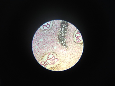 Federation University Historical Collection
Scientific Object, Norman H. Seward, Botanical Microscope Slides, c1950s
... Botanical Microscope Slides in a cardboard box. .1) Zea Mais Annular vessels .2) Protoceus .3) Yeast .4) Eryol .5) Stomata .6) Lichen Physcia Thallus .7) Lichen Cladonia mascilenta .8) Californian Lichen .9) Rhizome Pteris Longitudinal Section .10) Brake fern Pteris Transverse and Longitudinal sections .11) Rhizome Pteris Transverse Section .12) Selaginella sp. - Macro & Micro-sporangia .13) Ovule Pinus Longitudinal section .14) Rachis Pteris Transverse Section .15) Stem Pine Transverse Section ...microscope botanical microscope slides Botanical Microscope Slides in a cardboard box. .1) Zea Mais Annular vessels .2) Protoceus .3) Yeast .4) Eryol .5) Stomata .6) Lichen Physcia Thallus .7) Lichen Cladonia mascilenta .8) Californian Lichen .9) Rhizome Pteris Longitudinal Section .10) Brake fern Pteris Transverse and Longitudinal sections .11) Rhizome Pteris Transverse Section .12) Selaginella sp. - Macro & Micro-sporangia .13) Ovule Pinus Longitudinal section .14) Rachis Pteris Transverse Section .15) Stem Pine Transverse Section Botanical Microscope Slides Scientific Object Norman H. ...Botanical Microscope Slides in a cardboard box. .1) Zea Mais Annular vessels .2) Protoceus .3) Yeast .4) Eryol .5) Stomata .6) Lichen Physcia Thallus .7) Lichen Cladonia mascilenta .8) Californian Lichen .9) Rhizome Pteris Longitudinal Section .10) Brake fern Pteris Transverse and Longitudinal sections .11) Rhizome Pteris Transverse Section .12) Selaginella sp. - Macro & Micro-sporangia .13) Ovule Pinus Longitudinal section .14) Rachis Pteris Transverse Section .15) Stem Pine Transverse Section microscope, botanical microscope slides -
 Bendigo Historical Society Inc.
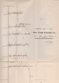
Map - STRUGNELL COLLECTION: UNDERGROUND SURVEY OF MINES, BENDIGO, 29-3-01
... Map, Underground Survey of Mines, New Chum Railway Co., New Chum Line, Transverse Section....A.S.Whitelaw Map, Underground Survey of Mines, New Chum Railway Co., New Chum Line, Transverse Section. Map STRUGNELL COLLECTION: UNDERGROUND SURVEY OF MINES, BENDIGO. ...Map, Underground Survey of Mines, New Chum Railway Co., New Chum Line, Transverse Section.A.S.Whitelawmap, bendigo, new chum railway co. -
 Bendigo Historical Society Inc.
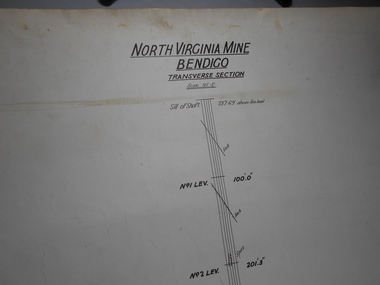
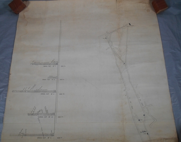
Administrative record - North Virginia Mine Bendigo Transverse Section
... Draftsman's drawing North Virginia Mine Transverse Section Map. Forms part of the Margaret Roberts Collection of mining records....Administrative record North Virginia Mine Bendigo Transverse Section ...Draftsman's drawing North Virginia Mine Transverse Section Map. Forms part of the Margaret Roberts Collection of mining records.bendigo, margaret roberts, gold, map, mine, north virginia mine bendigo -
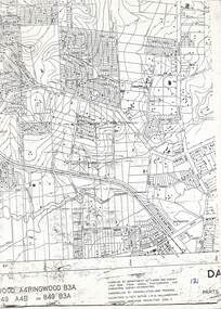 Ringwood and District Historical Society
Map, Heathmont/Bayswater Area Survey Map - 1956
... L.W.M. Williamstown. Transverse , Mercator Projection. Zone 7." ...L.W.M. Williamstown. Transverse , Mercator Projection. Zone 7." Cutaway section of black & white Dandenong Ranges Area survey map with countour lines centred over Bedford Road and Canterbury Road, Heathmont, and Bayswater Road and Wantirna-Sassafras Road (Mountrain Highway) Bayswater, Victoria. ...Cutaway section of black & white Dandenong Ranges Area survey map with countour lines centred over Bedford Road and Canterbury Road, Heathmont, and Bayswater Road and Wantirna-Sassafras Road (Mountrain Highway) Bayswater, Victoria. Chivers property marked on Armstrong Road, Heathmont.Caption: "Compiled by Department of Lands and Survey July 1956, from aerial photographs and cadastral survey informaton. Controlled by triangulation and traverse. Elevations in feet. Datum. L.W.M. Williamstown. Transverse , Mercator Projection. Zone 7." -
 Bendigo Historical Society Inc.
Plan - South Frederick The Great Mine, Sebastian
... Transverse and longitudinal plans on one sheet, of South Frederick The Great Mine, Sebastian. ...History Period of activity: 1871 (South Frederick the Great); 1881-1889 (Amalgamated South Frederick the Great); 1897-1906 (South Frederick the Great); 1933-1937 (South Frederick the Great) Line of reef: Sebastian/Carshalton Maximum recorded annual production: unknown Total production: 511ozs obtained from 1773 tons between 1934 and 1937 Deepest working level: 300 feet (Amalgamated South Frederick the Great) Deepest shaft: 307 feet (Amalgamated South Frederick the Great)(below water level) Source: City of Greater Bendigo: Marong Heritage Study chrome-extension://efaidnbmnnnibpcajpcglclefindmkaj/http://images.heritage.vic.gov.au/attachment/70493Mining Sites Bendigo Margaret Roberts gold South Frederick the Great Mine Margaret Roberts Collection Sebastian Transverse and longitudinal plans on one sheet, of South Frederick The Great Mine, Sebastian. ...SOUTH FREDERICK THE GREAT MINE Location Unreserved Crown Land along the southern boundary of Sebastian School, east of Three Chain Road, Frederick the Great/Carshalton Reef, Sebastian Map Reference Raywood 1:25000 - BV488.447 Mine site: Capped shaft still surrounded by its mullock paddock. At the base of the paddock on the northern side is a concrete winding engine foundation measuring 8 by 4 feet, and standing 2 feet high. The foundation has ¾-inch mounting bolts. Battery site 70 metres to the west of the mine site are the concrete foundations of a 10head battery. The foundations measure 16 by 11 feet, and stand 4 feet high. Part of the battery's loading ramp still survives, and on the eastern side of the battery foundations is a large concrete engine foundation. Near this engine foundation is a 3 foot square concrete pad, which still retains a circular impression. Presumably this was a stand for a gas producer cylinder. Located between the battery and the mine site is a rubbish dump which contains sections of an iron stack, and perhaps the remains of the gas producer cylinder. History Period of activity: 1871 (South Frederick the Great); 1881-1889 (Amalgamated South Frederick the Great); 1897-1906 (South Frederick the Great); 1933-1937 (South Frederick the Great) Line of reef: Sebastian/Carshalton Maximum recorded annual production: unknown Total production: 511ozs obtained from 1773 tons between 1934 and 1937 Deepest working level: 300 feet (Amalgamated South Frederick the Great) Deepest shaft: 307 feet (Amalgamated South Frederick the Great)(below water level) Source: City of Greater Bendigo: Marong Heritage Study chrome-extension://efaidnbmnnnibpcajpcglclefindmkaj/http://images.heritage.vic.gov.au/attachment/70493Mining SitesTransverse and longitudinal plans on one sheet, of South Frederick The Great Mine, Sebastian. Forms part of the Margaret Roberts Collection of mining records.bendigo, margaret roberts, gold, south frederick the great mine, margaret roberts collection, sebastian -
 Bendigo Historical Society Inc.
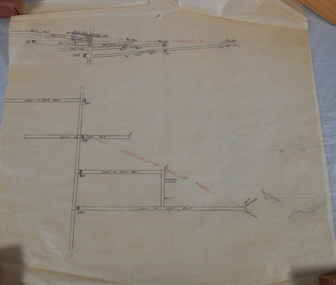
Plan - Mine Map
... Transverse section of un-named mine showing underground workings and geological features. ...History House 11 Mackenzie Street Bendigo goldfields Bendigo Margaret Roberts gold Map Mine Margaret Roberts Collection Transverse section of un-named mine showing underground workings and geological features. ...Transverse section of un-named mine showing underground workings and geological features. Forms part of the Margaret Roberts Collection of mining records.bendigo, margaret roberts, gold, map, mine, margaret roberts collection -
 Bendigo Historical Society Inc.
Plan - Confidence Cornish Kochs & Windmill Hill
... Draftsman's drawing Confidence, Cornish, Kochs & Windmill Hill Long and Transverse Sections. Forms part of the Margaret Roberts Collection of mining records....Bendigo Margaret Roberts gold Map Mine Margaret Roberts Collection Confidence Cornish Kochs & Windmill Hill Draftsman's drawing Confidence, Cornish, Kochs & Windmill Hill Long and Transverse Sections. Forms part of the Margaret Roberts Collection of mining records. ...Koch's Pioneer Gold Mine: Koch's Pioneer Quartz Mining and Crushing Company was officially registered on June 30th., 1871 (Government Gazette No. 45, 1871). It operated at Long Gully, the first Manager was Andrew Lewis. Nominal capital was 90,000 pounds in thirty thousand shares of 3 pounds each. The initial partnership in a quartz crushing plant between Henry Koch, Simon Albert and Charles Wallin was dissolved in 1860 with Koch becoming the sole owner. In 1866 the crushing plant consisted of a 50 hp engine and 48 stamping heads capable of crushing 600 tons of quartz per week. By 1902 there were 72 stamps and this was by far the largest crushing plant in the area, serving many quartz mines. Henry Koch (1800-1889) was a German sailor who signed off when his ship reached Melbourne in 1851. Having heard of the gold discovery he proceeded to Bendigo where he was initially employed in puddling in the Myers Flat area. He was soon employed and then made partner in a quartz crushing plant that he became sole owner of in 1860. He was also landlord at the British and American Hotel and the Silver Mines Hotel. HE also started the Perseverance United gold claim. He married Anna Maria Theresia Heinz in 1857. In 1872 he sold the crushing plant for 75,000 pounds and took his family back to Germany. He resumed his trade as a ship builder although he maintained many Bendigo mining interests.Draftsman's drawing Confidence, Cornish, Kochs & Windmill Hill Long and Transverse Sections. Forms part of the Margaret Roberts Collection of mining records.bendigo, margaret roberts, gold, map, mine, margaret roberts collection, confidence cornish kochs & windmill hill -
 Bendigo Historical Society Inc.
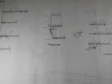
Map - Tambour Major Gold Mine
... Plan drawn on tan paper: transverse section of Tambour Major Mine, showing main shaft, Christmas Reef anticlinal axis line and fault line. ...Written on top of plan: Tambour Major Mine, Transverse Section, 100 ft to 1". 11469 tons yielded 3800 oz gold. ...Tambour Major Gold Mine was located in Specimen Hill, closest intersection: Specimen Hill and Marong Roads. Plan drawn on tan paper: transverse section of Tambour Major Mine, showing main shaft, Christmas Reef anticlinal axis line and fault line. Written on top of plan: Tambour Major Mine, Transverse Section, 100 ft to 1". 11469 tons yielded 3800 oz gold. Plan forms part of the Margaret Roberts Collection.gold mining, gold, bendigo, tambour major gold mine, specimen hill -
Clunes Museum
Plan - PLANS, NEW NORTH CLUNES MINE - UNDERGROUND WORKINGS
... .1 HEADER PAGE: "UNDERGROUND WORKINGS - NEW NORTH CLUNES MINE" .2 PLAN .3 PLAN TRANSVERSE SECTIONS .4 PLAN LONGITUDINALSECTIONS...Clunes Museum 36 Fraser Street enter building through Collins Place Clunes goldfields UNDERGROUND WORKINGS NEW NORTH CLUNES MINE .2 "656" PRINTED ON PLAN (FRONT)" .3 PRINTED ON PLAN R-272/.S/1B .4 R-272/S/1A .1 HEADER PAGE: "UNDERGROUND WORKINGS - NEW NORTH CLUNES MINE" .2 PLAN .3 PLAN TRANSVERSE SECTIONS .4 PLAN LONGITUDINALSECTIONS NEW NORTH CLUNES MINE - UNDERGROUND WORKINGS Plan PLANS ....1 HEADER PAGE: "UNDERGROUND WORKINGS - NEW NORTH CLUNES MINE" .2 PLAN .3 PLAN TRANSVERSE SECTIONS .4 PLAN LONGITUDINALSECTIONS.2 "656" PRINTED ON PLAN (FRONT)" .3 PRINTED ON PLAN R-272/.S/1B .4 R-272/S/1Aunderground workings, new north clunes mine -
Port Melbourne Historical & Preservation Society
Plan - Pickles Street, Town of Emerald Hill and Borough of Sandridge, Sep 1881
... Town of Emerald Hill and Borough of Sandridge plan for Pickles Street, including transverse and longitudinal sections - Spring to Graham. ...Port Melbourne Historical & Preservation Society Port Melbourne Town Hall 333 Bay Street Port Melbourne melbourne Engineering - Roads Streets Lanes and Footpaths Charles CLAY Signed by Charles Clay Town of Emerald Hill and Borough of Sandridge plan for Pickles Street, including transverse and longitudinal sections - Spring to Graham. ...Town of Emerald Hill and Borough of Sandridge plan for Pickles Street, including transverse and longitudinal sections - Spring to Graham. NB "bridge" near Liardet Street.Signed by Charles Clayengineering - roads streets lanes and footpaths, charles clay -
Port Melbourne Historical & Preservation Society
Plan - Construction of Liardet Street, Port Melbourne, John Foly?, Draughtsperson, 1860 - 1884
... Working drawing: longitudinal section, ground plan, transverse section for the construction of Liardet Street between Nott Street and Railway Place. ...Port Melbourne Historical & Preservation Society Port Melbourne Town Hall 333 Bay Street Port Melbourne melbourne Engineering - Roads Streets Lanes and Footpaths Engineering Department - Borough of Sandridge Charles CLAY John FOLY Liardet Street "Borough of Sandridge":"Chas Clay":"John Foly" Working drawing: longitudinal section, ground plan, transverse section for the construction of Liardet Street between Nott Street and Railway Place. ...Working drawing: longitudinal section, ground plan, transverse section for the construction of Liardet Street between Nott Street and Railway Place. Between 1860 and 1884."Borough of Sandridge":"Chas Clay":"John Foly"engineering - roads streets lanes and footpaths, engineering department - borough of sandridge, charles clay, john foly, liardet street -
 Bendigo Historical Society Inc.
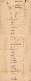
Document - VIRGINIA MINE
... Transverse section of the Virginia mine on the Garden Gully line of Reef at Eaglehawk, being Plate V of Bulletin No. 47 from the Geological Survey Office at Bendigo...History House 11 Mackenzie Street Bendigo goldfields GOLD Goldfields virginia mine Gold mines Garden Gully line of Reef Virginia Mine Eaglehawk Geological Survey Office Bendigo Transverse section of the Virginia mine on the Garden Gully line of Reef at Eaglehawk, being Plate V of Bulletin No. 47 from the Geological Survey Office at Bendigo Document VIRGINIA MINE ...Transverse section of the Virginia mine on the Garden Gully line of Reef at Eaglehawk, being Plate V of Bulletin No. 47 from the Geological Survey Office at BendigoGeological Survey Office Bendigogold, goldfields, virginia mine, gold mines, garden gully line of reef, virginia mine , eaglehawk