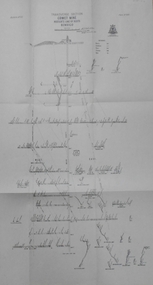
Showing 93 items matching "transverse section"
-
 Bendigo Historical Society Inc.
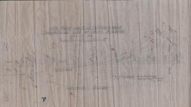
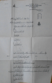
Map - RED WHITE & BLUE EXTENDED - PLAN OF RED WHITE AND BLUE EXTENDED MINE TRANSVERSE SECTION
... RED WHITE & BLUE EXTENDED - PLAN OF RED WHITE AND BLUE EXTENDED MINE TRANSVERSE SECTION... Plan of Red White & Blue Extended Mine Transverse Section...Transverse section of the Red White & Blue Extended Mine on the Sheepshead Line of Reef showing shafts, depths and geological features. ...Map RED WHITE & BLUE EXTENDED - PLAN OF RED WHITE AND BLUE EXTENDED MINE TRANSVERSE SECTION ...Transverse section of the Red White & Blue Extended Mine on the Sheepshead Line of Reef showing shafts, depths and geological features. Drawn on tracing film in pencil. Signed by J J Caldwell, District Field Geologist, Mines Department, Bendigo and dated 5/12/1940. Notes prepared by Albert Richardson.document, gold, red white & blue extended, red white & blue extended, plan of red white & blue extended mine transverse section, j j caldwell, mines dept bendigo -
 Bendigo Historical Society Inc.
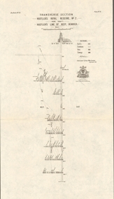
Map - COMET MINE - TRANSVERSE SECTION COMET MINE
... COMET MINE - TRANSVERSE SECTION COMET MINE...... Transverse Section of Comet Mine Bulletin No 33 Plate No XXV...Transverse section of the Comet Mine on the Hustler's Line of Reef Bulletin No 33, Plate No XXV signed by H. ...Map COMET MINE - TRANSVERSE SECTION COMET MINE ...Transverse section of the Comet Mine on the Hustler's Line of Reef Bulletin No 33, Plate No XXV signed by H. A. Whitdon, Underground Survey Office Bendigo September,1913. Map shows depth of the different levels, the type of stone and shaft about 2020 deep. A number of smaller drawings on the side. Reference explaining the different types of stone, etc. Geological Survey of Victoriamining, hustler's line of reefs, transverse section of comet mine bulletin no 33 plate no xxv, lightning hill line of reef -
 Bendigo Historical Society Inc.
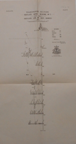
Map - HUSTLER'S CONSOLS MINE - TRANSVERSE SECTION OF THE HUSTLER'S CONSOLS MINE
... HUSTLER'S CONSOLS MINE - TRANSVERSE SECTION OF THE HUSTLER'S CONSOLS MINE...... Transverse Section of the Hustler's Consols Mine...Transverse Section of the Hustler's Consols Mine Bulletin No 33, Plate No XXXIII. ...History House 11 Mackenzie Street Bendigo goldfields MINING Parish Map Hustler's Consols Mine Transverse Section of the Hustler's Consols Mine Geological Survey of Victoria Underground Survey Office Bendigo H A Whitelaw Transverse Section of the Hustler's Consols Mine Bulletin No 33, Plate No XXXIII. ...Transverse Section of the Hustler's Consols Mine Bulletin No 33, Plate No XXXIII. Map shows poppet legs at the surface and Sill of Shaft 779.42 feet above Sea Level. Shows the different levels and their depths and the different stone and geographical features encountered. Has larger drawing of Section A - B. Geographical Survey of Victoria. Signed by H A Whitelaw, Underground Survey Office Bendigo, September 1913. mining, parish map, hustler's consols mine, transverse section of the hustler's consols mine, geological survey of victoria, underground survey office bendigo, h a whitelaw -
 Bendigo Historical Society Inc.
Map - K. K. MINE - TRANSVERSE SECTION K. K. MINE
... K. K. MINE - TRANSVERSE SECTION K. K. MINE...... Transverse Section of K. K. Mine...Transverse Section of the K. K. Mine on the Hustler's Line of Reefs, Bulletin No 33, Plate No XXXII. ...History House 11 Mackenzie Street Bendigo goldfields Miners Fortuna Hustler's Mine Transverse Section of K. K. Mine Hustler's Line of Reefs Geological Survey of Victoria H S Whitelaw Transverse Section of the K. ...Transverse Section of the K. K. Mine on the Hustler's Line of Reefs, Bulletin No 33, Plate No XXXII. Map shows the different levels and their depth. Also, the different types of stone encountered and geological features such as spurs and faults. Has drawing of the poppet legs at the top of the shaft and sill of shaft 773.56 ft above sea level. Map has Geological Survey of Victoria crest and signed by H S Whitelaw, Underground Survey Office Bendigo, September 1913. miners, fortuna hustler's mine, transverse section of k. k. mine, hustler's line of reefs, geological survey of victoria, h s whitelaw -
 Bendigo Historical Society Inc.
Map - HUSTLER'S REEF MINE - TRANSVERSE SECTION OF THE HUSTLER'S REEF MINE
... HUSTLER'S REEF MINE - TRANSVERSE SECTION OF THE HUSTLER'S REEF MINE...... transverse Section of the Hustler's Reef Mine...Transverse Section of the Hustler's Reef Mine on the Hustler's Line of Reefs. ...Transverse Section of the Hustler's Reef Mine on the Hustler's Line of Reefs. ...Transverse Section of the Hustler's Reef Mine on the Hustler's Line of Reefs. Bulletin No 33, Plate No XVIII. Shows cross-cuts and their depth, different types of stone and geological features encountered. Drawing of poppet legs at the surface and Sill of Shaft 756.39 ft above Sea Level. Reference Table shows key to the different stone and geographical features encountered. Geographical Survey of Victoria. Signed by H A Whitelaw, Underground Survey Office, Bendigo, September 1913. Thompson's Reef is also mentioned on the map. mining, hustler's reef mine, transverse section of the hustler's reef mine, geological survey of victoria, h a whitelaw, underground survey office bendigo, thompson's reef. -
 Bendigo Historical Society Inc.
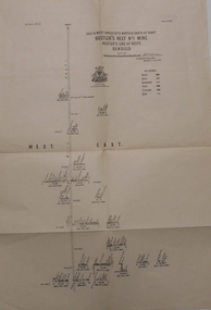
Map - GREAT EXTENDED HUSTLER'S MINE - TRANSVERSE SECTION OF THE GREAT EXTENDED HUSTLER'S MINE
... GREAT EXTENDED HUSTLER'S MINE - TRANSVERSE SECTION OF THE GREAT EXTENDED HUSTLER'S MINE...... Transverse Section of the Great Extended Hustler's Mine...Transverse Section of the Great Extended Hustler's Mine on the Hustler's Line of Reef. ...History House 11 Mackenzie Street Bendigo goldfields MINING Parish Map Great Extended Hustler's Mine Transverse Section of the Great Extended Hustler's Mine Old Shaft Mr Walker Mr Craven Geological Survey of Victoria Underground Survey Office Bendigo H A Whitelaw Transverse Section of the Great Extended Hustler's Mine on the Hustler's Line of Reef. ...Transverse Section of the Great Extended Hustler's Mine on the Hustler's Line of Reef. Bulletin No 33, Plate No XII. Shows Poppet legs at the surface and Sill of Shaft at 788.99 feet above Sea Level, Cross Cuts and their depths, stone and geographical features encountered and their references and a number of enlarged drawing of sections of the crosscuts, Geological Survey of Victoria emblem and signed by H A Whitelaw, Underground Survey Office Bendigo, September 1913. The depths of crosscuts to No 21 were taken from plans of surveys by Mr. Walker and Mr. Craven, noted under Reference. Another note: This Saddle Reef is sketched from Mr. Walker's plan. Dividends amounting to 360,000 pounds were obtained from it. mining, parish map, great extended hustler's mine, transverse section of the great extended hustler's mine, old shaft, mr walker, mr craven, geological survey of victoria, underground survey office bendigo, h a whitelaw -
 Federation University Historical Collection
Plan, Prince Regent Co. Transverse Section
... Prince Regent Co. Transverse Section...Transverse section of the Prince Regent Company....Transverse Section Plan ...Transverse section of the Prince Regent Company.prince regent co, foster allan, ernest lidgy, cgt -
 Federation University Historical Collection
Plan, Llanberris Co. Transverse Section, not dated
... Llanberris Co. Transverse Section...Printed transverse section of the Llanberris Company...Transverse Section Plan Plan ...Printed transverse section of the Llanberris Companyunderground survey, llanberris mine, llanberris co, ballarat -
 Federation University Historical Collection
Plan, Sulieman Pasha Co Plan Transverse Section
... Sulieman Pasha Co Plan Transverse Section...A transverse section plan of the Sulieman Pasha Mine....Sulieman Pasha Co Plan Transverse Section Plan Plan ...The Sulieman Pasha is possibly named after the most important Sultan of the Ottoman Empire, Suleiman One, or Suleiman the Magnificent, when the Ottoman Empire was at its peak. Or potentially a number of Ottoman governors, statesmen and military commanders with the same name after, however the spelling is slightly different to the mine name. No Turkish connection was found relating to the formation of the company, and remains unconfirmed. The mine operated from two shafts; No. 1 near the corner of Humffray and Mair streets, and also near where the Welcome Nugget (2217 ounces) was found years earlier; and the controversial No. 2 shaft several blocks south bordering the northern side of the main highway through Ballarat. The company produced 62 666 ounces of gold, the twelfth highest quartz reef gold production for any mine on the Ballarat goldfield. Some crushing figure examples are January-June 1881: 3674 tonnes 1085 ounces; January-June 1885: 2949 tonnes 1281 ounces; July-December 1885: 4459 tonnes 1119 ounces; January-June 1887: 1869 tonnes 730 ounces; July-December 1892: 1450 tonnes 771 ounces; July-December 1896: 4365 tonnes 1372 ounces. Like many mines in the area, gold grades were low. John Watson was noted as mine manager in the 1880s, and John Williams 1890s. The company was re-organised twice increasing the number of shares from 4000 to 24 000, and increasing the capital available. The Sulieman Pasha Company was formed in 1878. David Fitzpatrick was given the honour of turning the first sod of both the No.1 and later No. 2 shafts. The first dividend was given to shareholders in July 1881. The company obtained a prospecting vote (government grant) to start, and was very proud to be the first Victorian gold mining company to pay the funds back to the government. The event was marked by a lavish banquet laid out for ministers and government officials by the company. Leases were purchased to the south in 1885 to the Llanberris Mine boundary, after poor results began accumulating from the small No. 1 shaft. To take advantage of this new land the company planned to sink a second shaft. Initially this was to take place on government land, but the uproar from nearby residents caused the company to purchase land along the Main Road (now Western Highway), and the old Yarrowee Hotel which had occupied the site since the alluvial digger days of the 1850's was demolished. The area had since those days become heavily occupied with a number of shops, houses, a post office, church and two schools in the immediate area. The thought of an underground mine next door drew considerable opposition. The company (before the days of public relations departments) wrote 'most people would have thought that progress as vital as mining would be supported by tradesmen whose business rely on the mining industry. It seems when it comes to mining they are bereft of their senses, and considering the low ebb of mining in Ballarat East, the action of our opponents are unaccountable. (Sarcastically) There are certain engineering difficulties in moving the quartz reefs to a new location, but if we could to appease our opponents we would'. The company also wanted to take over 4 acres of the St Paul's school oval for machinery, but accused the St Paul's Church of wanting extortionate amounts of money upfront, and on a yearly basis for the privilege. It stated the church could not be opposed to mining when several years earlier it had formed its own company to mine the land, only for shareholders to lose their money. In 1886, the company approached the Minister for Mines, and attended heated public meetings on the matter. The local residents, shop owners, and church submitted a 60 person petition to the local council and government authorities. They stated the shaft contravened the mining statutes, which stating no mining could take place within 150 yards of a public building or church. A speech by a resident stated 'mining always comes with glorious pictures of the great benefits which would accrue all parties concerned if their request is granted, but if property is destroyed or depreciated in value, no-one then comes forward and compensates them'. The No. 2 shaft was approved including taking over part of the school oval. In 1888, workers at the company's No. 2 shaft went on strike to try and bring their wages in line with other mines in the district (the No. 1 shaft was operated by tributers). William Madden (26) was killed from a fall of earth underground the same year, while a year later his father John Madden (70) was similarly killed in the Madame Berry Mine elsewhere in the district. In 1897 as the amount of gold being found fell away, it came to light part of the deal to purchase the Yarrowee Hotel site was a 5% royalty on gold found. Shareholders could not understand why they were paying a royalty to the former owners of the property. The mine closed in 1898 due to a lack of gold. In 1902 a boy (age unknown) called Charles Lee was killed from a fractured skull while working to dismantle the Sulieman Pasha plant. The fuss over the No. 2 shaft had a sequel. On the company winding up, the land was purchased by J.S. Trethowan who built a house next to the shaft. In 1907, the shaft caved-in creating a sinkhole immediately at the back of the house. A Mr Chamberlain heard a deep rumbling sound at 5am, and looked out the window to see his fowl house and thirteen chickens disappear down an expanding hole. He then went back to bed, and called the police later in the day. The shaft was 1050 feet deep, and the hole at the surface that developed was 20 feet by 17 feet across, and 20 feet depth. In 1930 it is reported a syndicate had been formed to clean out the old shaft, and re-open the mine. It is assumed this was the No. 1 shaft but no more was found. (https://www.mindat.org/loc-304239.html, accessed 07/08/2019) A transverse section plan of the Sulieman Pasha Mine.sulieman pasha company, plan, mining, united black hill mine, victoria united mine, victoria street, britannia united mine, last chance mine, llanberris mine, ottoman empire, john watson, john williams, david fitzpatrick -
 Bendigo Historical Society Inc.
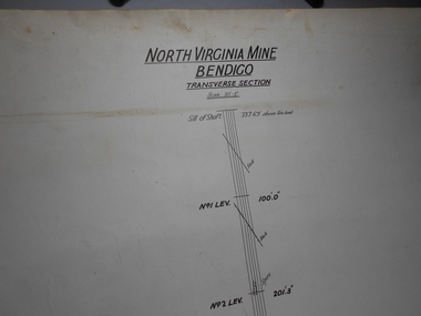
Administrative record - North Virginia Mine Bendigo Transverse Section
... North Virginia Mine Bendigo Transverse Section...Draftsman's drawing North Virginia Mine Transverse Section Map. Forms part of the Margaret Roberts Collection of mining records....Administrative record North Virginia Mine Bendigo Transverse Section ...Draftsman's drawing North Virginia Mine Transverse Section Map. Forms part of the Margaret Roberts Collection of mining records.bendigo, margaret roberts, gold, map, mine, north virginia mine bendigo -
 Ballarat Tramway Museum
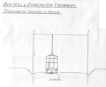
Document - Photocopy, "Box Hill - Doncaster Tramway, Transverse Section of Road", c1990?
... "Box Hill - Doncaster Tramway, Transverse Section of Road"...Photocopy of a drawing showing the proposed transverse sections of the Box Hill to Doncaster Tramway. ..."Box Hill - Doncaster Tramway, Transverse Section of Road" Document Photocopy ...Photocopy of a drawing showing the proposed transverse sections of the Box Hill to Doncaster Tramway. Drawing prepared at a scale of 4 feet to the inch. Shows the dimensioned sections with the tramcar, poles, sleepers and metal ballast in cutting and in bank (fill). Photocopy larger than original drawing. Has part of a stamp in the lower right hand corner.trams, tramways, box hill, doncaster, plans, sections -
 Bendigo Historical Society Inc.
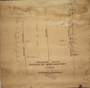
Plan - Napoleon, Nell Gwynne Transverse Section, 14.1.1946
... Napoleon, Nell Gwynne Transverse Section...Printed on bottom of plan" Transverse Section Napoleon and Nell Gwynne Lines of Reef' and 'J.J. ...Plan Napoleon, Nell Gwynne Transverse Section ...Napoleon Lease no.11111 is situated immediately south from the Golden Square railway station. It embraces an approx length of 36 chains of the Napoleon Anticline. The old Napoleon shaft, the depth of which is 1020 ft, occupies a central position in the area of about 43 acres. The accompanying sections, which are prepared from mine Managers plans, illustrate the extent of previous underground operations and indicate points at which future prospecting may be advantageously continued. The no.10 (920 ft) south level connects with the main Napoleon shaft no.5 level (479 ft) appears to present the best opportunity for testing the prospects that are believed to have been inadequately investigated by the Bendigo Mines Limited in recent years.Map drawn on heavy paper. Printed on bottom of plan" Transverse Section Napoleon and Nell Gwynne Lines of Reef' and 'J.J. Caldwell, District Field Geologist, Mines Department, Bendigo. 14.1.46'. Napoleon anticline and Central Nell Gwynne anticline marked on map. Map is part of the Margaret Roberts Collection of mining documents. gold mining, bendigo, napoleon gold mine, nell gwynne, reef lines, j.j. caldwell, 1946 -
 Bendigo Historical Society Inc.
Map - FORTUNA HUSTLER'S MINE - TRANSVERSE SECTION OF THE FORTUNA HUSTLER'S MINE
... FORTUNA HUSTLER'S MINE - TRANSVERSE SECTION OF THE FORTUNA HUSTLER'S MINE...Transverse Section of the Fortuna Hustler's Mine on the Hustler's Line of Reef, Bendigo. ...Map FORTUNA HUSTLER'S MINE - TRANSVERSE SECTION OF THE FORTUNA HUSTLER'S MINE ...Transverse Section of the Fortuna Hustler's Mine on the Hustler's Line of Reef, Bendigo. Bulletin No 33, Plate No III. Drawing shows poppet legs on the surface and Sill of Shaft 745.38 feet above Sea Level. Shows levels and their depths, geographical features and stone encountered. Reference table to stone and geographical features. Geographical Survey of Victoria emblem. Signed by H A Whitelaw, Underground Survey Office, Bendigo. mining, fortuna hustler's mine, hustler's line of reef, geological survey of victoria, underground survey office bendigo, h a whitelaw -
 Bendigo Historical Society Inc.
Map - UNITED HUSTLER'S & REDAN MINE - TRANSVERSE SECTION UNITED HUSTLER'S & REDAN MINE
... UNITED HUSTLER'S & REDAN MINE - TRANSVERSE SECTION UNITED HUSTLER'S & REDAN MINE...Transverse Section of the United Hustler's & Redan Mine on the Hustler's Line of Reefs Bulletin No 33, Plate No XXIX. ...Map UNITED HUSTLER'S & REDAN MINE - TRANSVERSE SECTION UNITED HUSTLER'S & REDAN MINE ...Transverse Section of the United Hustler's & Redan Mine on the Hustler's Line of Reefs Bulletin No 33, Plate No XXIX. Map has drawing of poppet legs on the surface, depth of levels, type of stone encountered and some geological features. Sill of shaft 745.62 ft above sea level. Map has Geological Survey of Victoria emblem and signed by H S Whitelaw, Underground Survey Office Bendigo, 'September 1913. mining, parish map, united hustler's & redan mine, hustler's line of reef, geological survey of victoria, h s whitelaw -
 Bendigo Historical Society Inc.
Map - HUSTLER'S ROYAL RESERVE NO 2 CO - TRANSVERSE SECTION OF THE HUSTLER'S ROYAL RESERVE NO 2 CO
... HUSTLER'S ROYAL RESERVE NO 2 CO - TRANSVERSE SECTION OF THE HUSTLER'S ROYAL RESERVE NO 2 CO...Transverse Section of the Hustler's Royal Reserve No 2 Co Mine on the Hustler's Line of Reef Bendigo, Bulletin No 33, Plate No VII. ...Map HUSTLER'S ROYAL RESERVE NO 2 CO - TRANSVERSE SECTION OF THE HUSTLER'S ROYAL RESERVE NO 2 CO ...Transverse Section of the Hustler's Royal Reserve No 2 Co Mine on the Hustler's Line of Reef Bendigo, Bulletin No 33, Plate No VII. Section shows the poppet legs and the sill of Shaft at 707.65 ft above sea level, depth of levels, stone encountered and geological features. Geological Survey of Victoria emblem. H. Herman Director, W. Dickson Secretary of Mines and The Hon. J. Drysdale Brown MLC, Minister of Mines. Signed by H S Whitelaw, Underground Survey Office Bendigo, September 1913. mining, parish map, hustler's royal reserve no 2 co, h s whitelaw, undergrou;nd survey office bendigo, geological survey of victoria, h herman, w dickson, the hon. j drysdale brown mlc -
 Bendigo Historical Society Inc.
Map - HUSTLER'S ROYAL RESERVE NO 2 (PARK SHAFT.) - TRANSVERSE SECTION OF THE HUSTLER'S ROYAL RESERVE NO 2
... HUSTLER'S ROYAL RESERVE NO 2 (PARK SHAFT.) - TRANSVERSE SECTION OF THE HUSTLER'S ROYAL RESERVE NO 2...Transverse section of the Hustler's Royal Reserve, No 2 (Park Shaft.) on the Hustler's Line of Reef. ...Map HUSTLER'S ROYAL RESERVE NO 2 (PARK SHAFT.) - TRANSVERSE SECTION OF THE HUSTLER'S ROYAL RESERVE NO 2 ...Transverse section of the Hustler's Royal Reserve, No 2 (Park Shaft.) on the Hustler's Line of Reef. Bulletin No 33, Plate No IX. Section shows poppet legs and sill of shaft at 755.70 ft above sea level, depth of levels, type of stone encountered including lava and geological features. Geological Survey of Victoria emblem and beneath it H. Herman, Director, W. Dickson, Secretary of Mines and The Hon. J. Drysdale Brown MLC Minister of Mines and signed by H S Whitelaw, Underground Survey Office, Bendigo September 1913.mining, parish map, hustler's royal reserve no 2 (park shaft.), h s whitelaw, underground survey office bendigo, geological survey of victoria, h herman, w dickson, the hon j drysdale brown mlc, hustler's line of reef -
 Bendigo Historical Society Inc.
Map - HUSTLER'S REEF NO 1 MINE - TRANSVERSE SECTION OF THE HUSTLER'S REEF NO 1 MINE
... HUSTLER'S REEF NO 1 MINE - TRANSVERSE SECTION OF THE HUSTLER'S REEF NO 1 MINE...Map of a transverse Section of the Hustler's Reef No 1 Mine on the hustler's Line of Reefs Bulletin No 33, Plate No XXI. ...Map HUSTLER'S REEF NO 1 MINE - TRANSVERSE SECTION OF THE HUSTLER'S REEF NO 1 MINE ...Map of a transverse Section of the Hustler's Reef No 1 Mine on the hustler's Line of Reefs Bulletin No 33, Plate No XXI. Map shows poppet legs at 801.07 feet above Sea Level and drawing of shaft with the different levels. Also shown are geological features and stone encountered. Geological Survey of Victoria emblem H Herman, Director, W Dickson, Secretary of Mines and The Hon. J. Drysdale Brown MLC Minister of Mines. Signed by H S Whitelaw, Underground Survey Office Bendigo, September 1913. This item has not been scanned or photographed.mining, parish map, hustler's reef no 1 mine, hustler's line of reefs, geological survey of victoria, underground survey office bendigo, h s whitelaw, h herman, w dickson, the hon j drysdale brown -
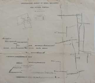 Federation University Historical Collection
Plan, Underground Survey of Mines Ballaarat, New Victoria Company, not dated
... ...transverse section...Printed transverse section of the New Victoria Company....underground survey new victoria company transverse section mining plan Printed transverse section of the New Victoria Company. ...Printed transverse section of the New Victoria Company.underground survey, new victoria company, transverse section, mining, plan -
 Bendigo Historical Society Inc.
Plan - South New Moon MIne
... ...transverse section...Transverse section of South New Moon Mine showing shaft and levels. ...South New Moon Mine was located near Sailor's Gully Road, Eaglehawk, approx 250 metres north of Moon Street. . gold mining gold Bendigo transverse section South New Moon Mine Eaglehawk Transverse section of South New Moon Mine showing shaft and levels. ...South New Moon Mine was located near Sailor's Gully Road, Eaglehawk, approx 250 metres north of Moon Street. . Transverse section of South New Moon Mine showing shaft and levels. Hand drawn on paper. Hand written on bottom 'South New Moon'. Plan forms part of the Margaret Roberts Collection. gold mining, gold, bendigo, transverse section, south new moon mine, eaglehawk -
 Bendigo Historical Society Inc.
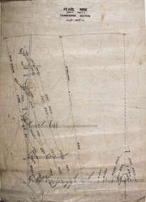
Plan - Pearl Gold Mine
... ...transverse section...Written on top of plan 'Pearl Mine, south shaft, transverse section, Scale 100 ft = 1 inch'. Plan forms part of the Margaret Roberts Collection of mining records. ...Margaret Roberts gold gold mine Bendigo Pearl Gold Mine Stone Street Long Gully south shaft transverse section Drawn on paper with black pen. ...The Pearl Gold Mine was near Stone Street, Long Gully.Drawn on paper with black pen. Written on top of plan 'Pearl Mine, south shaft, transverse section, Scale 100 ft = 1 inch'. Plan forms part of the Margaret Roberts Collection of mining records. margaret roberts, gold, gold mine, bendigo, pearl gold mine, stone street, long gully, south shaft, transverse section -
 Bendigo Historical Society Inc.
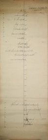
Plan - Confidence Extended Co, Unknown
... ...transverse section...Handwritten name inscribed: 'N.Cundy, 8.2.10'. Transverse section of mine shaft, annotated with geological features and depths. ...Handwritten name inscribed: 'N.Cundy, 8.2.10'. Transverse section of mine shaft, annotated with geological features and depths. ...The Confidence Extended Gold Mine was located near the corner of Taylor Street and Upper California Road, Long Gully. CONFIDENCE EXTENDED This company, as will be soon by the plan, has a large lease holding on the extension of the line. The main shaft, which is in a fairly central position, is down about 2350 ft., while the lowest level at the N. shaft is at 1403ft. After making- allowances for the northerly pitch of the country, it is calculated that the main shaft would require to be deepened about 600ft. in order to pick lip the continuation of the reef being opened up successfully in the "Windmill Hill mine. 'Bendigo Advertiser' 7th May 1909.Printed in black text on top of plan: 'Confidence Extended Co'. Handwritten name inscribed: 'N.Cundy, 8.2.10'. Transverse section of mine shaft, annotated with geological features and depths. Plan forms part of the Margaret Roberts Collection.gold mining, gold, bendigo, transverse section, confidence extended gold mine -
 Bendigo Historical Society Inc.
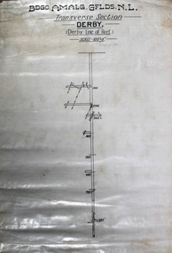
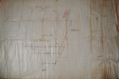
Map - Derby Line of Reef, Unknown
... ...transverse section...(Bendigo Amalgamated Goldfields N.L.) Transverse Section, Derby, Derby Line of Reef. Scale 100' = 1". ...(Bendigo Amalgamated Goldfields N.L.) Transverse Section, Derby, Derby Line of Reef. Scale 100' = 1". ...Informit: Lease application no.11038 contains a length of about 48 chains of the Paddy's Gully line of reefs. The Derby Anticline penetrates the area from its north boundary for a distance ofabout 30 chains at which point the fold disappears southwards. The outcrop of the Paddy's Gully Anticline is exposed in McClure Street. Along this section of the Paddys Gully line the top of what is regarded as 'favorable beds' occurs about 150 feet from the surface. It is estimated that the containing beds of Ladam's reef and the Garden Gully 300 feet reef, both of which proved to have been rich ore bodies on the Garden Gully line adjoining on the west, will be found at the approximate depth of 550 feet onthe Paddy's Gully line near the intersection of McClure and Bannerman Streets. A shorter vertical point of attack, though the position is less favorable geologically, is kocks Pioneer east shaft which is 420 feet deep. A crosscut east from this shaft ata depth of 200 feet reaches the Derby Line in a distance of 700 feet. (https://search.informit.org/doi/10.3316/aesis.200104712) Printed in black text on top of plan: 'Bgo Amalg Gflds N.L." (Bendigo Amalgamated Goldfields N.L.) Transverse Section, Derby, Derby Line of Reef. Scale 100' = 1". Plan forms part of the Margaret Roberts Collection.gold mining, gold, bendigo, derby, derby line of reef, transverse section -
 Bendigo Historical Society Inc.
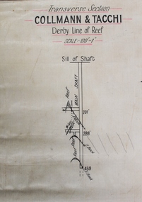
Map - Collmann and Tacchi, Unknown
... ...transverse section...Printed in black text on top of plan: 'Transverse section, Collmann & Tacchi, Derby line of reef'. ...Collman and Tacchi Gold Mine was located near the intersection of Eaglehawk Road and Rule Street, Long Gully. gold mining gold Bendigo Collman and Tacchi transverse section Printed in black text on top of plan: 'Transverse section, Collmann & Tacchi, Derby line of reef'. ...Collman and Tacchi Gold Mine was located near the intersection of Eaglehawk Road and Rule Street, Long Gully. Printed in black text on top of plan: 'Transverse section, Collmann & Tacchi, Derby line of reef'. Plan shows shaft, sill of shaft, and geological features. Scale 100' = 1". Plan forms part of the Margaret Roberts Collection.gold mining, gold, bendigo, collman and tacchi, transverse section -
 Bendigo Historical Society Inc.
Plan - New Golden Fleece Mine
... ...transverse section...Transverse section New Golden Fleece Mine. Plan shows shaft and levels. ...The New Golden Fleece Gold Mine was located approx. one km west of the Spring Gully Reservoir, Spring Gully, nearby to the Altona Gold Mine. gold mining gold Bendigo Golden Square transverse section Diamond Hill Diamond Hill Road New Golden Fleece Mine Transverse section New Golden Fleece Mine. ...The New Golden Fleece Gold Mine was located approx. one km west of the Spring Gully Reservoir, Spring Gully, nearby to the Altona Gold Mine. Transverse section New Golden Fleece Mine. Plan shows shaft and levels. The mine was located on Diamond Hill, near Diamond Hill Road: https://bendigo.gold/ Plan is signed by W.H. Cundy, 27.9.10. Plan forms part of the Margaret Roberts Collection.gold mining, gold, bendigo, golden square, transverse section, diamond hill, diamond hill road, new golden fleece mine -
 Bendigo Historical Society Inc.
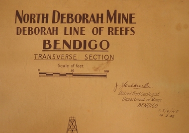
Plan - North Deborah Mine, 28.4.40 and 10.2.42
... ...transverse section...Written on top in bold black text: ' North Deborah Mine, Deborah Line of Reef, Bendigo, Transverse Section' Signed by J.J. Caldwell. Printed under name: 'District Field Geologist, Department of Mines, Bendigo' 28.4.40 and 10.2.42, printed under title. ...It is readily accessible, is visible from the Deborah site, Chum Hill and various other places around central Bendigo, and has views both to Chum Hill and the Deborah site. gold mining gold Bendigo North Deborah Gold Mine Eve Street Breen Street Golden Square transverse section Light tan heavy paper plan. Written on top in bold black text: ' North Deborah Mine, Deborah Line of Reef, Bendigo, Transverse Section' Signed by J.J. ...North Deborah Gold Mine was located near Eve Street and Breen Street, Golden Square. :The company occupying this site was the leading gold producer of the Deborah line of reef during the 1930's mining revival period. The site is reserved for mining, contains the only brick mine chimney still standing. It is readily accessible, is visible from the Deborah site, Chum Hill and various other places around central Bendigo, and has views both to Chum Hill and the Deborah site.Light tan heavy paper plan. Written on top in bold black text: ' North Deborah Mine, Deborah Line of Reef, Bendigo, Transverse Section' Signed by J.J. Caldwell. Printed under name: 'District Field Geologist, Department of Mines, Bendigo' 28.4.40 and 10.2.42, printed under title. Plan shows poppet head, shaft and levels. Plan forms part of the Margaret Roberts Collection.gold mining, gold, bendigo, north deborah gold mine, eve street, breen street, golden square, transverse section -
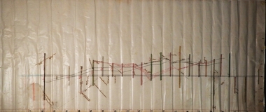
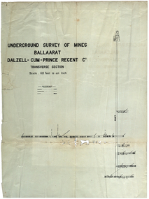 Federation University Historical Collection
Plan, Underground Survey of Mines Ballarat Dalzell-Cum-Prince Regent Co
... Transverse section...mining cgt dalzell-cum-prince plans Transverse section Underground Survey of Mines Ballarat Dalzell-Cum-Prince Regent Co. ...Transverse sectionmining, cgt, dalzell-cum-prince, plans -
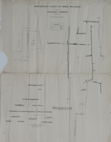 Federation University Historical Collection
Plan, Underground Survey of Mines, Ballaarat, not dated
... Printed transverse section of the Speedwell Company....underground survey speedwell company Printed transverse section of the Speedwell Company. Underground Survey of Mines, Ballaarat Plan Plan ...Printed transverse section of the Speedwell Company.underground survey, speedwell company -
 Federation University Historical Collection
Plan, North Prince Extended Co
... Transverse section of the North Prince Extended Co,...Barker Library (top floor) Mount Helen goldfields north prince extended mining company gold Transverse section of the North Prince Extended Co, North Prince Extended Co, Plan Plan ...Transverse section of the North Prince Extended Co,north prince extended, mining company, gold -
 Bendigo Historical Society Inc.
Plan - Russell's Reef, Lauriston
... ...transverse section...Russell’s Reef Amalgamated , No 2 shaft ( Company was formed c.1891 and appears to have mined more-or-less continuously until 1911) Source: chrome-extension://efaidnbmnnnibpcajpcglclefindmkaj/https://vhd.heritagecouncil.vic.gov.au/places/8099/download-report gold mining gold transverse section Lauriston Russell's Reef Kyneton Russell's Reef Amalgamated Co.Lauriston Plan forms part of the Margaret Roberts Collection. ...A quartz mine that dates from the early years of the 20th-century. The remains are located on a Water Reserve managed by Coliban Water. Location: Reservoir Road, Lauriston, Macedon Ranges Shire. The Russell’s Reef Amalgamated Company spent the early part of 1907 in developing the saddle reef. Defects found to exist in the winding gear, consequently the directors decided to obtain a new gear of the first-class type. This has been obtained and placed in position. Advantage was taken by the management of the suspension of underground operations to give the whole of the machinery and boilers at the No 1 shaft a thorough overhaul. It was found that the two boilers that had been in use required some slight repairs. This resulted in a new high pressure boiler which had been purchased some time previously has been built in and put into commission. In 1907 the shaft was 1,260 feet deep, and an average of 30 men were employed. Russell’s Reef Amalgamated , No 2 shaft ( Company was formed c.1891 and appears to have mined more-or-less continuously until 1911) Source: chrome-extension://efaidnbmnnnibpcajpcglclefindmkaj/https://vhd.heritagecouncil.vic.gov.au/places/8099/download-reportRussell's Reef Amalgamated Co.Lauriston Plan forms part of the Margaret Roberts Collection.gold mining, gold, transverse section, lauriston, russell's reef, kyneton -
 Bendigo Historical Society Inc.
Document - NORTH JOHNSONS MINE - NOTES ON THE NORTH JOHNSONS MINE
... E J Dunn's Special Report No 1 Measurements taken from North Johnsons Mine transverse Section 22/9/1892...History House 11 Mackenzie Street Bendigo goldfields DOCUMENT Gold north johnsons mine North Johnsons Mine Garden Gully Line of Reef Rose of Denmark Camerons Reef Dagmar Reef Johnsons No 1 Johnsons No 2 Special Edition Australian Mining Standard 1/6/1899 Mines Dept Booklet Bendigo Goldfield Geo Brown 1936 Mines Dept Quarterly and Annual Reports Annals of Bendigo Mining Sections 1866 - 1917 A Richardson E J Dunn's Special Report No 1 Measurements taken from North Johnsons Mine transverse Section 22/9/1892 Wood & McNair Sharebrokers Plan of leases of portion of Bendigo Goldfield to 4/5/1912 One typed, one handwritten and one handwritten carbon copy of notes on the North Johnsons Mine on the Garden Gully Line of Reef. ...One typed, one handwritten and one handwritten carbon copy of notes on the North Johnsons Mine on the Garden Gully Line of Reef. Notes include size of lease (which was very small, only 83 yards along the line of reef, and the late 1890's absorbed the Rose of Denmark lease, the next mine north, of 57 yeards along the line of reef, Depth of shaft, height of Sill, Locality, Plant, Early History, Prominence, Best Gold, Total Gold Yield and Dividends,Underground Connections and References. Albert Richardson Collection. document, gold, north johnsons mine, north johnsons mine, garden gully line of reef, rose of denmark, camerons reef, dagmar reef, johnsons no 1, johnsons no 2, special edition australian mining standard 1/6/1899, mines dept booklet bendigo goldfield geo brown 1936, mines dept quarterly and annual reports, annals of bendigo mining sections 1866 - 1917, a richardson, e j dunn's special report no 1 measurements taken from north johnsons mine transverse section 22/9/1892, wood & mcnair sharebrokers plan of leases of portion of bendigo goldfield to 4/5/1912