Showing 102 items matching "tree survey"
-
 Rutherglen Historical Society
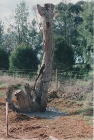
Image, Survey Tree, Jacks Road
... Survey Tree, Jacks Road...tree...survey reference marks...Original blazed survey tree was removed and then replaced by Gas Workers...Colour photograph of the remains of a survey tree, concreted into the ground...Survey marks on tree blaze...Rutherglen Historical Society Murray Street Rutherglen high-country Original blazed survey tree was removed and then replaced by Gas Workers tree survey reference marks blazed tree jacks road Survey marks on tree blaze Colour photograph of the remains of a survey tree, concreted into the ground Survey Tree, Jacks Road Image ...Original blazed survey tree was removed and then replaced by Gas WorkersColour photograph of the remains of a survey tree, concreted into the groundSurvey marks on tree blazetree, survey reference marks, blazed tree, jacks road -
 Rutherglen Historical Society
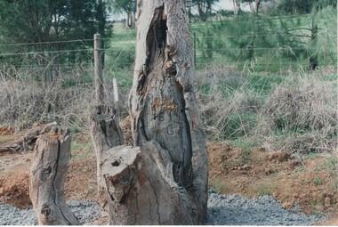
Image, Survey Tree, Jacks Road
... Survey Tree, Jacks Road...tree...survey reference marks...Original blazed survey tree was removed and then replaced by Gas Workers...Colour photograph of the remains of a survey tree, concreted into the ground. This photo is a close-up to better show the survey marks....Survey marks on tree blaze...Rutherglen Historical Society Murray Street Rutherglen high-country Original blazed survey tree was removed and then replaced by Gas Workers tree survey reference marks blazed tree jacks road Survey marks on tree blaze Colour photograph of the remains of a survey tree, concreted into the ground. ...Original blazed survey tree was removed and then replaced by Gas WorkersColour photograph of the remains of a survey tree, concreted into the ground. This photo is a close-up to better show the survey marks.Survey marks on tree blazetree, survey reference marks, blazed tree, jacks road -
 Bendigo Military Museum
Photograph - Removal of Sequoia Californian Redwood Tree - Army Survey Regiment, Fortuna, Bendigo, 1994
... Removal of Sequoia Californian Redwood Tree - Army Survey Regiment, Fortuna, Bendigo. ...Removal of Sequoia Californian Redwood Tree - Army Survey Regiment, Fortuna, Bendigo. ...These nine photographs of contractors felling a sequoia Californian redwood tree was taken at the Army Survey Regiment, Fortuna, Bendigo on the 16th of September 1994. ...This is a set of nine photographs of contractors felling a Sequoia (Californian redwood) tree at the Army Survey Regiment, Fortuna, Bendigo on the 16th of September 1994. ...Removal of Sequoia Californian Redwood Tree - Army Survey Regiment, Fortuna, Bendigo. Photograph Removal of Sequoia Californian Redwood Tree - Army Survey Regiment, Fortuna, Bendigo. ...These nine photographs of contractors felling a sequoia Californian redwood tree was taken at the Army Survey Regiment, Fortuna, Bendigo on the 16th of September 1994. Although 23 photos were taken at the time, 14 were not scanned due to their similarity to the nine featured photos. Two sequoia Californian redwood trees were planted at the front entrance of Fortuna Villa in the early days of gold mining magnate George Lansell’s occupation in the 1870’s. They were of immense proportion and much admired during the Lansell era and RA Svy’s occupation from 1942 to 1996. In these early days of Army occupation, the trees were lopped due to concerns of their size and proximity to the Villa. The felling of the tree in 1994 was considered unsafe due to perceptions of disease. These perceptions were upsetting to staff, as some believed that although there were a few dead branches, the tree was OK. As the tree had a noticeable lean, measurements were taken indicating the tree was stable. A sequoia sapling was eventually planted as a replacement to the diseased tree. It was decided to mill and store the timber of the felled tree on-site due to its historical significance. Although future uses were not determined at the time, the timber was eventually used to construct display cabinets and souvenir pens. When Defence decided to relocate geospatial production to a new facility in Junortoun an outer suburb of Bendigo in 2008, the sequoia timber was used as a beautiful feature in the front foyer as well as several feature walls within the building, providing a historical connection Fortuna Villa.This is a set of nine photographs of contractors felling a Sequoia (Californian redwood) tree at the Army Survey Regiment, Fortuna, Bendigo on the 16th of September 1994. The colour photographs were printed on photographic paper and are part of the Army Survey Regiment’s Collection. The photographs were scanned at 300 dpi. .1) - Photo, colour, 1994, Felling of sequoia Californian redwood tree. .2) - Photo, colour, 1994, Felling of sequoia Californian redwood tree. Neil Morgan (ground maintenance) is hugging the tree. .3) - Photo, colour, 1994, Felling of sequoia Californian redwood tree. .4) to .8) - Photo, colour, 1994, Felling of sequoia Californian redwood tree. .9) - Photo, colour, 1994, background on left - WO2 Bob Garritty, foreground L to R: Geoff (ground maintenance), unidentified, Neil Morgan (ground maintenance)..1P to .9P – No personnel are identified.royal australian survey corps, rasvy, army survey regiment, army svy regt, fortuna, asr -
 University of Melbourne, Burnley Campus Archives
Plan, Delysia Westwood, Tree Survey Central Gardens, 1986
... Tree Survey Central Gardens......tree survey...Dated November 1986 by Delysia Westwood. Scale 1:500. Tree Survey Central Gardens Plan Delysia Westwood ...Numbered plan with legend of trees in Central Gardens [Hawthorn]: Height, Diameter, Rating and comments for each tree. Dated November 1986 by Delysia Westwood. Scale 1:500.delysia westwood, tree survey, central gardens -
University of Melbourne, Burnley Campus Archives
Document, South Oakleigh Secondary College - Senior Campus. Tree Hazard Survey, 1997
... South Oakleigh Secondary College - Senior Campus. Tree Hazard Survey......tree hazard survey...South Oakleigh Secondary College - Senior Campus. Tree Hazard Survey Document ...Centre for Urban Horticulture, 118 pp.urban horticulture, south oakleigh secondary college, tree hazard survey -
University of Melbourne, Burnley Campus Archives
Booklet, Centre for Urban Horticulture, South Oakleigh Secondary College - Junior Campus Tree Hazard Survey, 1997
... South Oakleigh Secondary College - Junior Campus Tree Hazard Survey......tree hazards...survey...South Oakleigh Secondary College - Junior Campus Tree Hazard Survey Booklet Centre for Urban Horticulture Found in Quad Classrooms 2018 ...south oakleigh secondary college, tree hazards, survey -
University of Melbourne, Burnley Campus Archives
Plan, "Invergowrie" Tree Survey Plan, 1989
... "Invergowrie" Tree Survey Plan...Dated 03.03.1989. "Invergowrie" Tree Survey Plan Plan ...Dyeline plan drawn by W. Klein. Numbered trees with position in garden. Dated 03.03.1989.invergowrie, w. klein -
University of Melbourne, Burnley Campus Archives
Plan, John Patrick Pty. Ltd, Banyule Gallery Tree Survey, 1988
... Banyule Gallery Tree Survey...Banyule Gallery Tree Survey Plan John Patrick Pty. Ltd ...Plan by John Patrick Pty. Ltd. For W.R. Johnston Trust. DRG No104/88701, November 1988. Drawn by P. Mills. Scale 1:200. Plants numbered but no legend.john patrick pty. ltd., w.r. johnston, banyule gallery, heidelberg -
 Stawell Historical Society Inc
Photograph, Survey Tree with markings at Lake Lonsdale -- 2 Photos
... Survey Tree with markings at Lake Lonsdale -- 2 Photos...Survey Tree at Lake Lonsdale...Stawell Historical Society Inc 46 Longfield St Stawell grampians Survey Tree at Lake Lonsdale Stawell Survey Tree with markings at Lake Lonsdale -- 2 Photos Photograph ...Survey Tree at Lake Lonsdalestawell -
University of Melbourne, Burnley Campus Archives
Plan, Kirsten Strutt, Central Gardens Hawthorn, 1996
... Scale 1:500. (1) Site Analysis September 1986. (2) Tree Survey October 1986 Drawing No 2....Scale 1:500. (1) Site Analysis September 1986. (2) Tree Survey October 1986 Drawing No 2. Central Gardens Hawthorn Plan Kirsten Strutt ...Plans by Kirsten Strutt (student) for Hawthorn City Council. Scale 1:500. (1) Site Analysis September 1986. (2) Tree Survey October 1986 Drawing No 2.kirsten strutt, hawthorn, gardens, central gardens hawthorn -
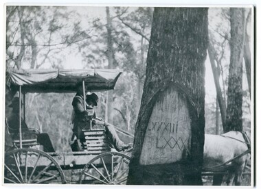 Orbost & District Historical Society
black and white photograph, 1913
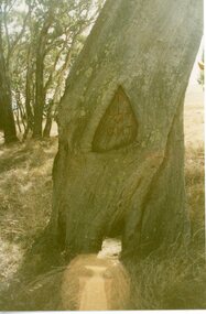
... survey-tree reference-tree...trees as reference marks to boundary corners. After July 1886 surveyors were able to use “permanent marks” which were either a glass bottle, gas pipe or iron bolt (for homestead surveys only). ...Old survey trees serve as one of the few remaining physical legacies of early European land settlement history. survey-tree reference-tree on back - " Refernce tree 83 miles from Marlo........to N.S.W. ...When marking a boundary for a registered plan, a surveyor would place “Reference Marks” with a stated bearing and distance to a boundary corner. These trees were typically marked by cutting the bark of the tree in a shield or blaze. Until July 1886, surveyors were only able to use trees as reference marks to boundary corners. After July 1886 surveyors were able to use “permanent marks” which were either a glass bottle, gas pipe or iron bolt (for homestead surveys only). This photograph shows the reference tree, 83 miles from Marlo via the original surveyed road v ia Sydenham Inlet and Tamboon, south of Mount Drummer to the New South Wales border - now the Princes Highway.This is a pictorial record of an old survet tree. Knowledge of their location, abundance and condition not only provide important insights to past survey practice, but also provide a lasting legacy of a regions land-use history. Old survey trees serve as one of the few remaining physical legacies of early European land settlement history.A large black / white photograph of a horse and buggy pulled up alongside a reference tree which has notches and markings of Roman numerals.on back - " Refernce tree 83 miles from Marlo........to N.S.W. Border"survey-tree reference-tree -
 Tatura Irrigation & Wartime Camps Museum
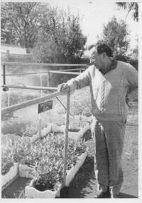
Photograph, Alan Brown, Tatura Tree Group, c1990s
... Tatura Tree Group, Alan Brown surveying seedlings, c1990s. Alan Brown is a retired manager of Rosella....Tatura Irrigation & Wartime Camps Museum 49 Hogan Street Tatura the-murray tatura locals tree group brown a rosella costume male rural industry horticulture Tatura Tree Group, Alan Brown surveying seedlings, c1990s. Alan Brown is a retired manager of Rosella. ...Tatura Tree Group, Alan Brown surveying seedlings, c1990s. Alan Brown is a retired manager of Rosella.tatura, locals, tree group, brown a, rosella, costume, male, rural, industry, horticulture -
University of Melbourne, Burnley Campus Archives
Plan, Blessington Street Gardens, 1983-1984
... Surveyed by Peter Herbert. Scale 1:250. (2) NE Quadrant. Drawing No 2136, 2 of 4. (3) SE Quadrant. Drawing No 2137, 3 of 4. (4) SW Quadrant. Drawing No 2138, 4 of 4. (5) Existing Conditions. Drawing No 2139, 1 of 1. Scale 1:500. (6) Redevelopment - Concept A. Designed by N. Hamey Sept '83 Scale 1:500. Drawing No 2140 1 of 2. (7) Tree...Drawing No 2140 1 of 2. (7) Tree Inventory. Surveyed by P. Herbert, traced by Greg Hocking Feb '84. ...City of St Kilda plans. (1) Existing Conditions: NW Quadrant. Drawing No. 2135 File No 8-134. 1 of 4 Surveyed by Peter Herbert. Scale 1:250. (2) NE Quadrant. Drawing No 2136, 2 of 4. (3) SE Quadrant. Drawing No 2137, 3 of 4. (4) SW Quadrant. Drawing No 2138, 4 of 4. (5) Existing Conditions. Drawing No 2139, 1 of 1. Scale 1:500. (6) Redevelopment - Concept A. Designed by N. Hamey Sept '83 Scale 1:500. Drawing No 2140 1 of 2. (7) Tree Inventory. Surveyed by P. Herbert, traced by Greg Hocking Feb '84. Drawing No 2140, 1 of 2.st kilda, blessington street gardens, peter herbert, greg hocking, trees -
 Bendigo Military Museum
Mixed media - SCRAPBOOK BENDIGO RSL, C. 1967 - 1972
... Survey Regiment. brsl smirsl scrapbook Page 8 hand written, "1969". Page 9, hand written names as per "Context" Six articles and Spiroflex sketch book. Page 7. Photo and article re the award of a Life Membership. Page 8. Photo and article re planting a Lone Pine tree ...This is the 2nd set of 6 pages from Scrap book Cat No 8225. Page 7a. Photo and article re Sam Ryan receiving a Life Membership of the RSL. Refer Cat No 8225. Page 7b. Photo and Article of Sam Ryan President Bendigo RSL receiving a cheque from Mr W.P. Casey Chairman of Directors of the Bendigo Easter Fair. Page 8. Phot and article 1969 re the planting of an Aleppo Pine tree from the original on Gallipoli. On the Left is Jack Plant President Bendigo RSL, the other two persons unknown as section of the text is missing. Page 9a. Anzac Appeal 1969, Mr John Ogden pins an Anzac token on the coat of Phillip Rice. Page 9b. From the "Mufti" RSL Magazine showing Delegates to the RSL State Conference 1969. Three of the six are known, W.B. Nicholls, D.J. Osborn, J. Hipworth State Councillor. Page 9c & d. Jack PLant in both photos on the left, other man unknown as well as place. Page 10. From the bendigo Advertiser relating to the Bendigo RSL Annual Dinner held on Saturday 10th 1971. From the left is G. Garth President Kangaroo Flat RSL, Lt Col W. Howarth Commanding Officer AHQ Survey Regiment, T. Shaw State Executive of the RSL, J Plant President Bendigo RSL, T Stephens Deputy Commissioner Repatriation Department and Cr N.J. Oliver the Mayor of Bendigo. Page 11a. Photo from a Bendigo RSL Annual Dinner year unknown, 2nd from the left is Bruce Ruxton State President of the Victorian RSL, 2nd from the right is possibly W.B. Nicholls, others onknown. Page 11b. This is a photo of RSL Annual Dinner 1971, same as per Page 10 for details. Page 12. Photograph of Bendigo RSL Annual Dinner year unknown. 2nd from the left is Jack Plant, the man to the left of man standing is possibly W. Howarth CO Survey Regiment.Six articles and Spiroflex sketch book. Page 7. Photo and article re the award of a Life Membership. Page 8. Photo and article re planting a Lone Pine tree. Page 9. Two articles and two photos re Appeals and State Conference. Page 10. Photo and article re RSL Annual Dinner. Page 11. Two photos re RSL Annual Dinners. Page 12. One photo re RSL Annual Dinner. Page 8 hand written, "1969". Page 9, hand written names as per "Context"brsl, smirsl, scrapbook -
 Bendigo Military Museum
Photograph - Army Survey Regiment - Fortuna & Surrounds, Bendigo, Army Survey Regiment - Fortuna Interior, Bendigo, c1987-1989
... Survey Squadron’s Building. Technical Services, Building 16B at right. .6) - Photo, black & white, c1987-1989. Fortuna Villa – view of lake towards tennis courts. .7) - Photo, black & white, c1987-1989. Fortuna Villa – Pompeii Fountain in front garden. .8) - Photo, black & white, c1987-1989. Fortuna Villa – statue on top of the Pompeii Fountain’s pillar. .9) - Photo, black & white, c1987-1989. Fortuna Villa – view of Litho buildings and newly constructed Wayzgoose Hall Print Building from rooftop. .10) - Photo, black & white, c1987-1989. Fortuna Villa – view of sequoia trees...Survey Squadron’s Building. Technical Services, Building 16B at right. .6) - Photo, black & white, c1987-1989. Fortuna Villa – view of lake towards tennis courts. .7) - Photo, black & white, c1987-1989. Fortuna Villa – Pompeii Fountain in front garden. .8) - Photo, black & white, c1987-1989. Fortuna Villa – statue on top of the Pompeii Fountain’s pillar. .9) - Photo, black & white, c1987-1989. Fortuna Villa – view of Litho buildings and newly constructed Wayzgoose Hall Print Building from rooftop. .10) - Photo, black & white, c1987-1989. Fortuna Villa – view of sequoia trees ...This set of 12 photographs of the Army Survey Regiment’s Fortuna Villa and surrounding facilities was taken circa 1987 to 1989. The photos feature much of Fortuna’s exterior and most of the out-buildings spread over the property’s fifteen acres of grounds. After Defence took possession of Fortuna in 1942, the Q-store and engineering workshops were added during the wartime period. Soldiers were accommodated in tents during WW2 for 20 years next to the parade ground before the construction of accommodation buildings in 1962. In 1990 most of the weatherboard buildings in the Q-store area were replaced. A climate-controlled building was also constructed to house a map library and digital data media. This photo set also includes the exterior of Air Survey Squadron’s Building 16 and two modular buildings -16A and 16B that were added in the early 1980s to accommodate map production and technical services. See item 6456.30P for more photos of Fortuna Villa and its surrounding facilities. This set of 12 photographs of the Army Survey Regiment’s Fortuna Villa and surrounding facilities was taken circa 1987 to 1989. The photographs are on 35mm negative film and scanned at 96 dpi. They are part of the Army Survey Regiment’s Collection. .1) - Photo, black & white, c1987-1989. Fortuna Villa – front view. .2) - Photo, black & white, c1987-1989. Fortuna Villa – view of lake towards tennis courts. .3) - Photo, black & white, c1987-1989. Fortuna Villa – view of lake towards OR’s Barracks. .4) - Photo, black & white, c1987-1989. Fortuna Villa – back view. .5) - Photo, black & white, c1987-1989. View of Fortuna Villa from Air Survey Squadron’s Building. Technical Services, Building 16B at right. .6) - Photo, black & white, c1987-1989. Fortuna Villa – view of lake towards tennis courts. .7) - Photo, black & white, c1987-1989. Fortuna Villa – Pompeii Fountain in front garden. .8) - Photo, black & white, c1987-1989. Fortuna Villa – statue on top of the Pompeii Fountain’s pillar. .9) - Photo, black & white, c1987-1989. Fortuna Villa – view of Litho buildings and newly constructed Wayzgoose Hall Print Building from rooftop. .10) - Photo, black & white, c1987-1989. Fortuna Villa – view of sequoia trees and lake from rooftop. .11) - Photo, black & white, c1987-1989. Fortuna Villa – balcony view of Q-store and transport compound from rooftop. .12) - Photo, black & white, c1987-1989. Fortuna Villa – playground with tennis courts in background.There are no annotations.royal australian survey corps, rasvy, fortuna, army survey regiment -
 Bendigo Military Museum
Photograph - Military Funeral for SSGT Peter Dew, Army Survey Regiment, Fortuna, Bendigo, 1977
... On right of tree L to R: Max Neil, Bob Hayden, Dave Malligan, Le-Anne (Smallshaw) Shirley, Stan Vote. Remainder unidentified. Military Funeral for SSGT Peter Dew, Army Survey Regiment, Fortuna, Bendigo Photograph Military Funeral for SSGT Peter Dew, Army Survey Regiment, Fortuna, Bendigo Army Survey Regiment ...This is a set of five black & white photographs of troops from the Army Headquarters Survey Regiment undertaking ceremonial drill at the military funeral for SSGT Peter Dew in 1977. The location of the funeral service was at Fortuna, Bendigo. He was buried at Bendigo Cemetery in Quarry Hill. Peter Dew died in a tragic accident at home. He was fondly remembered as one of Lithographic Squadron’s colourful personalities. See item 6243.7P for photos of Peter Dew at work in Lithographic Squadron. The "Super Animal of the Year" Peter Dew Memorial Award was an award presented to a member of the squadron for a crude act. To view a photo of this award, refer to item 6230 of the Victorian Collections. This is a set of five black & white photographs of troops from the Army Headquarters Survey Regiment undertaking ceremonial drill at the military funeral for SSGT Peter Dew in 1977. The photographs were printed on photographic paper and are part of the Army Survey Regiment’s Collection. The photographs were scanned at 300 dpi. .1) - Photo, black & white, 1977. Unidentified soldiers and civilians. .2) - Photo, black & white, 1977. In front of the tennis court gates: John McCulloch. Remainder unidentified. .3) - Photo, black & white, 1977. Rifle party rear rank right marker: Russ Mollenhauer. Front rank rifle party commander next to right marker: Greg Kidman. Pall bearers in front of vehicle L to R: Dave Miles, Dick Barwald. Remainder unidentified. .4) - Photo, black & white, 1977. Rifle party commander: Greg Kidman. Right file front to back: Russ Mollenhauer, Peter Breukel, Bill Jones, John Anderson. Remainder unidentified. Left file front to back: unidentified (x2), Rhys De Laine, Frank Lenane, Josh Degroot, Gary Drummond. .5) - Photo, black & white, 1977. Left of minister: Alan Toogood. On right of tree L to R: Max Neil, Bob Hayden, Dave Malligan, Le-Anne (Smallshaw) Shirley, Stan Vote. Remainder unidentified.No personnel are identified.royal australian survey corps, rasvy, army survey regiment, army svy regt, fortuna, asr -
 Bendigo Military Museum
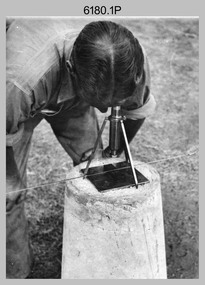
Photograph - RASvy Surveyors in the field, c1950s – 1960s
... He was CO of the Army Survey Regiment from 1982 to 1985. The surveyor in photo .13P is cutting an identification blaze on a tree using a hammer and chisel. ...Unidentified surveyor undertaking observations using a plane table. .10) – Photo, black & white, c1955, Jorge Gruszka undertaking observations with a theodolite. 7/55 Basic Survey Course Balcombe. .11) – Photo, black & white, c1950s, Jorge Gruszka undertaking observations with a theodolite. .12) – Photo, black & white, c1946-1948, unidentified surveyor undertaking observations with a theodolite to gain control for the mapping of the Snowy Mountain Diversion Scheme. .13) – Photo, black & white, c1950s, unidentified surveyor cutting a blaze in a tree. .14) and .15) – Photo, black & white, c1960s, Jim Stedman demonstrating EDM equipment. .16) – Photo, black & white, c1960s, L to R: Jim Stedman (probably) and unidentified surveyor demonstrating EDM equipment. .17) – Photo, black & white, 1956, Operation Cutlass - Surveyors SPR W. ...He was CO of the Army Survey Regiment from 1982 to 1985. The surveyor in photo .13P is cutting an identification blaze on a tree using a hammer and chisel. ...This is a set of 1photographs of surveyors in the field measuring distances using chains, taking observations using theodolites and operating electric distance measurement equipment. They were probably employed in establishing mapping and geodetic control operations or the surveyors may have been in training. The photos were most likely taken in the 1950s and 1960s. Photos .1P to .6P feature personnel setting up geodetic survey chaining equipment to measure distances. The surveyor in Photo .5P is LTCOL Howard Angus Johnson MBE who served from 1936 to 1954. The RA Svy surveyor in photos .7P to .12P were using a theodolite to take angular measurements. They were usually supported by an observer who recording their readings on a booking form. The surveyor in Photo .10P and .11P is LTCOL Jorge Gruszka, who served from 1955 to 1985. He was CO of the Army Survey Regiment from 1982 to 1985. The surveyor in photo .13P is cutting an identification blaze on a tree using a hammer and chisel. The tellurometer in Photos .14P to .16P was a MRA1 microwave Electronic Distance Measuring instrument (EDM) introduced in 1958. It and later models were man-portable systems that improved geodetic survey efficiencies for rapid network extension and densification replacing triangulation with EDM and theodolite traverse sometimes using Bilby Towers to extend line lengths. The surveyor with the slouch hat is Colonel James ‘Jim’ Leslie Stedman, who served from 1941 to 1978. He was Director of Military Survey from 1975 to 1978 and was appointed as Colonel Commandant (honorary appointment, Retd) of the Royal Australian Survey Corps from 1978 to 1983. Jim Stedman is demonstrating EDM equipment.This is a set of 17 photographs of surveyors in the field measuring distances using chains, taking observations using theodolites and operating electric distance measurement (EDM) equipment. c1950s – 1960s. The photographs were printed on photographic paper and are part of the Army Survey Regiment’s Collection. The photographs were scanned at 300 dpi. .1) - Photo, black & white, c1950s, unidentified personnel using geodetic survey chaining equipment. .2) to .4) - Photo, black & white, c1950s, geodetic survey chaining equipment. .5) – Photo, black & white, c1950s, Jim Stedman using geodetic survey chaining equipment to measure distances. .6) - Photo, black & white, c1950s, Unidentified personnel geodetic survey chaining equipment. .7) – Photo, black & white, mounted on card, c1950s. Unidentified surveyor undertaking observations on a coral reef using a theodolite. .8) – Photo, black & white, c1950, unidentified surveyor undertaking observations with a Tavistock theodolite. .9) – Photo, black & white, mounted on green card, c1950s. Unidentified surveyor undertaking observations using a plane table. .10) – Photo, black & white, c1955, Jorge Gruszka undertaking observations with a theodolite. 7/55 Basic Survey Course Balcombe. .11) – Photo, black & white, c1950s, Jorge Gruszka undertaking observations with a theodolite. .12) – Photo, black & white, c1946-1948, unidentified surveyor undertaking observations with a theodolite to gain control for the mapping of the Snowy Mountain Diversion Scheme. .13) – Photo, black & white, c1950s, unidentified surveyor cutting a blaze in a tree. .14) and .15) – Photo, black & white, c1960s, Jim Stedman demonstrating EDM equipment. .16) – Photo, black & white, c1960s, L to R: Jim Stedman (probably) and unidentified surveyor demonstrating EDM equipment. .17) – Photo, black & white, 1956, Operation Cutlass - Surveyors SPR W. Crane and J.A. Campbell undertaking observations with a theodolite in extreme conditions..1P on back - First Order Chaining Equipment .2P on back - First Order Chaining Equipment .3P on back - Full catenary 1800 – 1960 replaced by EDM .4P on back - First Order Chaining Equipment .5P on back - H.A. Johnson, Benambra baseline? 1st Order Chaining .6P on back - Chaining .7P on front - Difficult observing conditions especially when the tide is in. The station is sighted (sic) on a coral reef. .8P on back - Tavistock. .10P on back of duplicate in Photo Folder 14 – George (sic) Gruszka 7/55 Basic Survey Course Balcomme (sic) 1955/56 .14P and .15P on back - Jim Stedman demonstrating early EDM equipment.royal australian survey corps, rasvy, army survey regiment, army svy regt, fortuna, asr, surveying -
 Kiewa Valley Historical Society
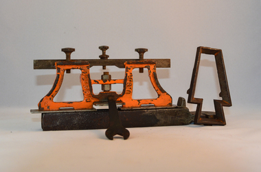
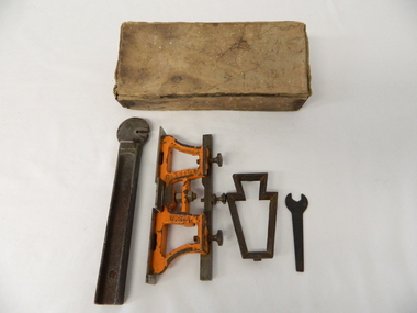
Sharpener Saw Raker/Jointer, early 1900s
... Surveys during this period and in the dense mountainous terrain of the Victorian Alps was both exhausting and hazardous. Overnight accommodation at various log cabins was not always possible and swag/tent alternative was the "fall back" hand tool saw sharpening method tree felling. ...This raker/jointer/guage set is a sharpening tool for cross cut logging saws. The logging saws used in the early 1900's for the clearing of forests required constant sharpening of their "cutting teeth". The logging of forested areas during these times was very much a "hands on" method of either one or two men by the use of saw or hand axe. Chain saws, chain and ball(clearing) and bulldozing methods came in the mid 1900's.This particular saw sharpening method was used by surveyors laying down boundaries for the S.E.C. Victoria Hydro Electricity Scheme (1920's). This item was given to a local Kiewa Valley lad who accompanied the initial surveyors. The lad was responsible for the tendering and feeding of the surveyors "pack horses". Surveys during this period and in the dense mountainous terrain of the Victorian Alps was both exhausting and hazardous. Overnight accommodation at various log cabins was not always possible and swag/tent alternative was the "fall back" This raker/jointer saw sharpener was made in the USA (DISSTON) from cast and flat iron. The main body has been painted in orange. It has three adjustment screws on the top horizontal bar and one bolt on(adjusting) leveling platform on the bottom. The small size and weight of this saw sharpener was ideal for the travelling/mobile logger or surveyor(as in this case). The main frame resembles two towers connected by two horizontal bars and the top of the towers has a horizontal bar with adjustment screws. See KVHS 0090 (B) for setting stake wedge adjusting the rake and cutting angle and KVHS 0090 (C) for a small spanner (for adjustments).On one inner supports is stamped "DISSTON" and on the other "U.S.A."hand tool, saw, sharpening method, tree felling. -
 Kiewa Valley Historical Society
Tool Spring Set, circa early 1900s
... Surveys work during this period and in these dense mountainous terrain of the Victorian Alps was both exhausting and hazardous. Overnight accommodation at various log cabins was not always possible and swag/tent alternative was the "fall back". hand tool saw sharpening method tree felling On one side of the bar "DISSTON U.S.A." ...This is part of a crosscut saw raker/jointer/guage set used to bend the tip of each cutter tooth for cross cut logging saws. The logging saws used in the early 1900's for the clearing of forests required constant sharpening of their "cutting teeth". The logging of forested areas during these times was very much a "hands on" method of either one or two men by the use of saw or hand axe. This item was used by the surveyors commissioned by The S.E.C. Victoria Kiewa Hydro Electricity Scheme project mapping the relevant Alpine region. Chain saws, chain and ball(clearing) and bulldozing methods came in the mid 1900's.This particular saw sharpening method was used by surveyors laying down boundaries for the S.E.C. Victoria Hydro Electricity Scheme (1920's). This item was given to a local Kiewa Valley lad who accompanied the initial surveyors. The lad was responsible for the tendering and feeding of the surveyors "pack horses". Surveys work during this period and in these dense mountainous terrain of the Victorian Alps was both exhausting and hazardous. Overnight accommodation at various log cabins was not always possible and swag/tent alternative was the "fall back".This cast iron Spring Setting tool has a main body of angle iron contours with one end tappered into a flat circular extension with a slit (3/32" wide) running from the top to nearly the centre(15mm). This slit is to allow the bending of each "cutter tooth" of the cross cut saw. The "bottom of this slit has a semi circular ending. Protruding from one side of the bar body, and close to the "slit" is a tounge like extension (wedge) to fasten the spring set tool into a tree stump. See KVHS 0090 (A) for its Raker/Jointer saw sharpening guage set partner. Also see KVHS 0090 (C) for the associated wrench. On one side of the bar "DISSTON U.S.A."hand tool, saw, sharpening method, tree felling -
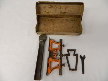 Kiewa Valley Historical Society
Spanner Small, 1920's
... Surveys during this period and in the dense mountainous terrain of the Victorian Alps was both exhausting and hazardous. Overnight accommodation at various log cabins was not always possible and swag/tent alternative was the "fall back" hand tool saw sharpening method tree felling. ...This spanner, part of a raker/jointer/guage set which is a sharpening tool for cross cut logging saws. The logging saws used in the early 1900's for the clearing of forests required constant sharpening of their "cutting teeth". The logging of forested areas during these times was very much a "hands on" method of either one or two men by the use of saw or hand axe. Chain saws, chain and ball(clearing) and bulldozing methods came in the mid 1900's.This particular spanner was part of a crosscut saw sharpening tool and method was used by surveyors laying down boundaries for the S.E.C. Victoria Hydro Electricity Scheme (1920's). This item was given to a local Kiewa Valley lad who accompanied the initial surveyors. The lad was responsible for the tendering and feeding of the surveyors "pack horses". Surveys during this period and in the dense mountainous terrain of the Victorian Alps was both exhausting and hazardous. Overnight accommodation at various log cabins was not always possible and swag/tent alternative was the "fall back"This small spanner is part of the Raker/Jointer Gauge saw set and is made from forged steel. The nut grip is of the two tightening nuts on the main construction frame. See KVHS 0090 (A &B) for the other items making up the sharpening tools.hand tool, saw, sharpening method, tree felling. -
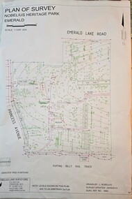 Emerald Museum & Nobelius Heritage Park
Map - Plan of Survey - Nobelius Heritage Park 2013, L. Nobelius, Nobelius Heritage Park, Plan of Survey 2013, c2013
... Topographical map of Nobelius Heritage Park/Denotes tree positions/Scale 1:1000 (A3)/drawn by L.NOBELIUS 20/3/2013/Survey Ref Number 5884/Nobelius Land Surveyors, PO Box 461, Pakenham 3810, Ph 03 9541 4112...Survey map printed by L. Nobelius Historical connection between surveyor and the park's creator Topographical map of Nobelius Heritage Park/Denotes tree positions/Scale 1:1000 (A3)/drawn by L.NOBELIUS 20/3/2013/Survey Ref Number 5884/Nobelius Land Surveyors, PO Box 461, Pakenham 3810, Ph 03 9541 4112 Image of Plan of Survey of Nobelius Heritage Park, Emerald Nobelius Heritage Park, Plan of Survey 2013 Map Plan of Survey - Nobelius Heritage Park 2013 L. ...Survey map printed by L. NobeliusHistorical connection between surveyor and the park's creatorImage of Plan of Survey of Nobelius Heritage Park, EmeraldTopographical map of Nobelius Heritage Park/Denotes tree positions/Scale 1:1000 (A3)/drawn by L.NOBELIUS 20/3/2013/Survey Ref Number 5884/Nobelius Land Surveyors, PO Box 461, Pakenham 3810, Ph 03 9541 4112 -
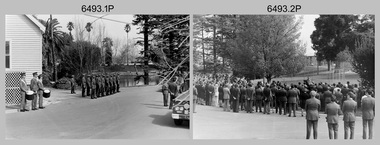 Bendigo Military Museum
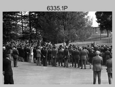
Photograph - Military Funeral for SSGT Peter Dew, Army Survey Regiment, Fortuna, Bendigo, 1977
... tree L to R: WO2 Max Neil, WO2 Bob Hayden, WO1 Dave Malligan, PTE Le-Anne (Smallshaw) Shirley, CAPT Stan Vote. Remainder unidentified. .26) - Photo, black & white, 1977. The rifle party fire volleys. .27) - Photo, black & white, 1977. The rifle party presents arms. .28) - Photo, black & white, 1977. Service at grave site. SGT Greg Francis-Wright 4th from right. .29) - Photo, black & white, 1977. Outside Litho’s proofing hut at Fortuna. WO1 Darby Munro stands in contemplation next to the collection of flowers. Military Funeral for SSGT Peter Dew, Army Survey ...This is a set of 29 black & white photographs of troops from the Army Headquarters Survey Regiment undertaking ceremonial drill at the military funeral for SSGT Peter Dew on the 28th of September 1977. The location of the funeral service was at Fortuna, Bendigo. He was buried at Bendigo Cemetery in Quarry Hill. Peter Dew died in a tragic accident at home. He was fondly remembered as one of Lithographic Squadron’s colourful personalities. See item 6243.7P for photos of Peter Dew at work in Lithographic Squadron. The "Super Animal of the Year" Peter Dew Memorial Award was an award presented to a member of the squadron for a crude act. To view a photo of this award, refer to item 6230 of the Victorian Collections. Some photos in this set were also printed on photo paper and catalogued under item 6335.5P.This is a set of 29 black & white photographs of troops from the Army Headquarters Survey Regiment undertaking ceremonial drill at the military funeral for SSGT Peter held in 1977. The photographs are on 35mm negative film and scanned at 96 dpi. They are part of the Army Survey Regiment’s Collection. .1) - Photo, black & white, 1977. Rifle party commander: CPL Greg Kidman. Right file right marker: SPR Russ Mollenhauer, unidentified soldiers and civilians. .2) - Photo, black & white, 1977. Unidentified soldiers and civilians. .3) - Photo, black & white, 1977. R to L: SSGT Alan Adsett, WO2 John McCulloch, SGT Graeme Jeffers in foreground holding hats. Remainder unidentified. .4) to .6) - Photo, black & white, 1977. Unidentified soldiers and civilians. R to L: SSGT Alan Adsett, WO2 John McCulloch, unidentified soldiers and civilians. .7) - Photo, black & white, 1977. Pall bearers position the coffin onto the gun carriage. Rifle party commander: CPL Greg Kidman. Right file right marker: SPR Russ Mollenhauer. Seen in background to the right of pall bearers: L to R: CPL Ian Belmont, unidentified, facing away- PTE Le-anne (Smallshaw) Shirley, CPL Di Chalmers, unidentified soldiers and civilians. .8) - Photo, black & white, 1977. Rifle party rear rank right marker: Russ Mollenhauer. Front rank rifle party commander next to right marker: Greg Kidman. Pall bearers in front of vehicle L to R: Dave Miles, Dick Barwald. Remainder unidentified. .9) - Photo, black & white, 1977. In position at beginning of funeral procession, unidentified soldiers and civilians. .10) & .11) - Photo, black & white, 1977. Rifle party commander: CPL Greg Kidman and the rifle party slow march past the front of Fortuna Villa. .12) - Photo, black & white, 1977. The rifle party slow march past the front of Fortuna Villa. Rifle party commander: Greg Kidman. Right file front to back: SPR Russ Mollenhauer, SPR Peter Breukel, SPR Bill Jones, SPR John Anderson. Remainder unidentified. Left file front to back: SPR Jeff Willey, unidentified, SPR Rhys De Laine, SPR Frank Lenane, SPR Josh Degroot, SPR Gary Drummond. .13) - Photo, black & white, 1977. The rifle party slow march past the front of Fortuna Villa. Rifle party commander: Greg Kidman. Right file: SPR Russ Mollenhauer, Left file: SPR Jeff Willey, remainder unidentified. .14) - Photo, black & white, 1977. The rifle party march at quick time towards the entry gate. .15) - Photo, black & white, 1977. The rifle party march at quick time past the front of Fortuna Villa. Rifle party commander: Greg Kidman. Right file: SPR Russ Mollenhauer, Left file: SPR Jeff Willey, remainder unidentified. .16) - Photo, black & white, 1977. The procession marches at quick time towards the entry gate. .17) - Photo, black & white, 1977. The procession departs the entry gate. .18) to .21)- Photo, black & white, 1977. The procession passes through the cemetery. .22) - Photo, black & white, 1977. The procession passes through the cemetery. RSM Wo1 Aub Harvey at far left. Remainder unidentified. .23) - Photo, black & white, 1977. Pallbearers carry Peter Dew’s coffin to the grave site. .24) - Photo, black & white, 1977. The rifle party in position at ‘rest on arms reverse’. .25) - Photo, black & white, 1977. Service at grave site. Left of minister: SGT Alan Toogood. On right of tree L to R: WO2 Max Neil, WO2 Bob Hayden, WO1 Dave Malligan, PTE Le-Anne (Smallshaw) Shirley, CAPT Stan Vote. Remainder unidentified. .26) - Photo, black & white, 1977. The rifle party fire volleys. .27) - Photo, black & white, 1977. The rifle party presents arms. .28) - Photo, black & white, 1977. Service at grave site. SGT Greg Francis-Wright 4th from right. .29) - Photo, black & white, 1977. Outside Litho’s proofing hut at Fortuna. WO1 Darby Munro stands in contemplation next to the collection of flowers.There are no personnel identified. royal australian survey corps, rasvy, army survey regiment, army svy regt, fortuna, asr, litho sqn -
Federation University Historical Collection
Booklet - Booklet - Media Clippings, University of Ballarat: Community Service Activities, 1994
... .; Study on Unhealthy Fitness - Heart Foundation suggests regular exercise at level suited to individual needs; Survey tracks path of yellow spotting; Tertiary push for hospital - Ararat; University considered for athletics facility; Top-level study on fitness for the elderly to be monitored by Human Movement and Sports Science students, University of Ballarat; Institute of Chartered Accountants will hold its annual accounting information day at the University of Ballarat's Foundation Hall. Students from other universities to attend; Prince Edward's visit - challenge of "Great Rubber Tube Raft Regatta" at Lake Wendouree; Uni, company in joint training initiative - installation on Novell's networking software in the degree course; Uni begins study into tree....; Study on Unhealthy Fitness - Heart Foundation suggests regular exercise at level suited to individual needs; Survey tracks path of yellow spotting; Tertiary push for hospital - Ararat; University considered for athletics facility; Top-level study on fitness for the elderly to be monitored by Human Movement and Sports Science students, University of Ballarat; Institute of Chartered Accountants will hold its annual accounting information day at the University of Ballarat's Foundation Hall. Students from other universities to attend; Prince Edward's visit - challenge of "Great Rubber Tube Raft Regatta" at Lake Wendouree; Uni, company in joint training initiative - installation on Novell's networking software in the degree course; Uni begins study into tree ...Booklet of article that appeared in the newspaper outlining events, programmes, etc. that are of community involvement. Computer and IT programmes; Uni helps kids learn about safe, active, healthy life; Uni eager to foster partnership with local community; Professor David James (Vice Chancellor) to be chair of regional consultation group reforming State's planning system; Ballarat's Martin Hughes of BU Geology Department and Queensland's Neil Phillips to present paper at Geological Society of America in Seattle; Uni to build aquatic centre to attract top swimmers; Open Days planned by Ballarat Universities; Sue Hadden, Ballarat Uni, received $75,000 grant to carry out research on Victoria's disappearing native grasses; Ballarat Uni to host major student sculpture show; Moves to develop high-tech park plan; New Research Plans assisted by Professor Tom O'Donnell; Indian experts look for answers to get more from their depleted desert forests; Uni conducts nursing survey re courses to be offered; Rabbit numbers rise - survey from farmers; Ted Lovett, VFL footballer (Fitzroy) talk on racism in sport at Ballarat Uni.; Australian beer awards at Ballarat Uni.; Study on Unhealthy Fitness - Heart Foundation suggests regular exercise at level suited to individual needs; Survey tracks path of yellow spotting; Tertiary push for hospital - Ararat; University considered for athletics facility; Top-level study on fitness for the elderly to be monitored by Human Movement and Sports Science students, University of Ballarat; Institute of Chartered Accountants will hold its annual accounting information day at the University of Ballarat's Foundation Hall. Students from other universities to attend; Prince Edward's visit - challenge of "Great Rubber Tube Raft Regatta" at Lake Wendouree; Uni, company in joint training initiative - installation on Novell's networking software in the degree course; Uni begins study into tree threat; Eureka leadership conference in Ballarat; Leadership conference an outstanding success.Buff coloured cover, black print. Pages glued and bound - black tape. Newspaper articles - photographs and print - on separate sheets in reverse order of appearance in paper; December to February.Symbol of University of Ballarat - cover.computer and it, newspaper items, health, local community involvement, david james, vice chancellor, state's planning system, martin hughes, geology department, neil phillips, queensland university, geological society of america, seattle, aquatic centre, sue hadden, research grant, $75000, native grasses, sculpture exhibitiontom o'donnell, indian experts, nursing survey, rabbit survey, ted lovett, footballer, racism in sport, australian beer awards, unhealthy fitness, heart foundation, athletics facility, fitness for the elderly, human movement and sports science, intitute of chartered accountants, networking system in degree course, eureka leadership conference -
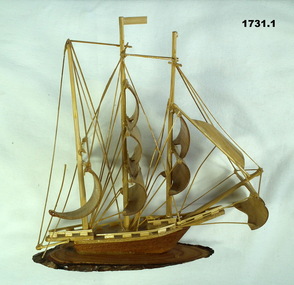 Bendigo Military Museum
Souvenir - BOAT MODELS, 1962-72
... Survey Corp 15.10.69 to 15.10.70. Refer 638P. handcrafts-sailor's craft woodwork Vietnam models .1 Model of a three masted ship made entirely of bamboo, mounted on a slice of timber. .2 Model of a two storey native stilt house with a tree made of a twig and painted polystyrene. ...The two models were collected from small village in South Vietnam by Geoff Murray No 3411521, Vietnam 3 Cav Regt 27.11.67 to 22.10.68, Survey Corp 15.10.69 to 15.10.70. Refer 638P..1 Model of a three masted ship made entirely of bamboo, mounted on a slice of timber. .2 Model of a two storey native stilt house with a tree made of a twig and painted polystyrene. Mounted on a slice of timber.handcrafts-sailor's craft, woodwork, vietnam, models -
 Orbost & District Historical Society
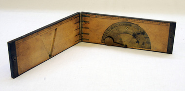
clinometer rule, mid 19th -earl 20th century
... surveying to measure vertical angles. It is used to measure the angle of elevation from the ground in a right-angled triangle. It may have been used by a surveyor or a forester to measure the height of tall things where you couldn't possibly reach to the top of e.g. flag poles, buildings or trees....surveying to measure vertical angles. It is used to measure the angle of elevation from the ground in a right-angled triangle. It may have been used by a surveyor or a forester to measure the height of tall things where you couldn't possibly reach to the top of e.g. flag poles, buildings or trees. ...This clinometer, is a hand-held optical scientific instrument used in surveying to measure vertical angles. It is used to measure the angle of elevation from the ground in a right-angled triangle. It may have been used by a surveyor or a forester to measure the height of tall things where you couldn't possibly reach to the top of e.g. flag poles, buildings or trees.This item is an example of an early hand held measuring instrument.. Today the use of electronic sensors is an important component in the design and function of the clinometers.A rectangular wooden folding measuring instrument. the panels are brass framed. Inside is a brass semi-protractorgraduated 90-0-90' with index arm pointeran dwith a graduated edge in inches. Outside is a temperature conversion scale,Troughton & Simms, LONDONscientific-instrument measurement clinometer -
 Orbost & District Historical Society
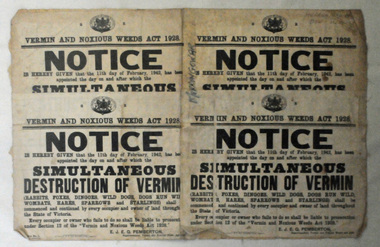
map/poster, Victorian Government Printer, 22.4.1926
... Survey. This map and posters are significant records of early settlement history in Murrangower, between Cabbage Tree and Orbost, map-Murrangower poster-vermin-and-noxious-weeds Murrangower-settlement "DON MEHLERT" in black pen. ...The Department of Crown Lands and Survey was originally established in 1857 as part of the Board of Land and Works. In 1964 it ceased to be controlled by the Board. The Department functioned for almost twenty more years before being combined with other Ministries to form the Department of Conservation, Forests and Land. It was responsible for the management of the State's Crown land and pastoral estates. This map was used by Don Mehlert after 1928. The VERMIN AND NOXIOUS WEEDS ACT 1928 was an Act to consolidate the Law relating relating to Vermin and Noxious Weeds. E. J. E. G. Pemberton who published this poster was Superintendent of Field Staff, Dept. of Lands and Survey. This map and posters are significant records of early settlement history in Murrangower, between Cabbage Tree and Orbost,A paper map of Murrangower showing settlement subdivisions. This is glued onto the back of four overlapping cloth poster of "Notices of Vermin Destruction". All print is black."DON MEHLERT" in black pen. Pike's block shaded in blue. School site marked in blue pencil. on poster "MURRANGOWAR" along side.map-murrangower poster-vermin-and-noxious-weeds murrangower-settlement -
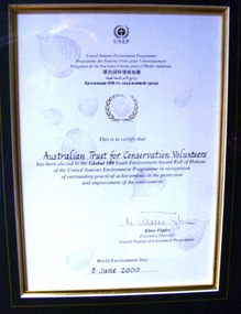 Conservation Volunteers
Award: Honour Roll, United Nations Environment Program (UNEP) - 1 June 2000 - The UNEP announced that the Australian Trust of Conservation Volunteers of Australia (ATCV), has been elected to the prestigious ranks of its Global 500 Roll of Honour for outstanding contributions to the protection of the environment, Award:United Nations Environment Program (UNEP) - 1 June 2000 - UNEP announced today that the ATCV has been elected to the prestigious ranks of its Global 500 Roll of Honour for outstanding contributions to the protection of the environment
... Activities range from bush regeneration, tree planting, seed collection, endangered species protection, weed control, flora and fauna surveys, walking trail construction, fencing, environmental monitoring and the protection of world heritage areas. ...Activities range from bush regeneration, tree planting, seed collection, endangered species protection, weed control, flora and fauna surveys, walking trail construction, fencing, environmental monitoring and the protection of world heritage areas. ...THE AUSTRALIAN TRUST OF CONSERVATION VOLUNTEERS, ONE OF 14 INDIVIDUALS AND ORGANIZATIONS, TO RECEIVE UNITED NATIONS ENVIRONMENT AWARD NAIROBI, 1 June 2000 - The United Nations Environment Programme (UNEP) announced today that the Australian Trust of Conservation Volunteers of Australia (ATCV), has been elected to the prestigious ranks of its Global 500 Roll of Honour for outstanding contributions to the protection of the environment. ATCV is one of 14 individuals and organizations to receive this honour in 2000. Founded in 1982, ATCV is a national, not-for-profit community organization, whose mission is to attract and manage a force of volunteers in practical conservation projects for the betterment of the Australian environment. ATCV completes more than 4000 week-long conservation projects in urban, regional and remote areas of Australia each year. Activities range from bush regeneration, tree planting, seed collection, endangered species protection, weed control, flora and fauna surveys, walking trail construction, fencing, environmental monitoring and the protection of world heritage areas. ATCV community participation has resulted in more than 1.8 million trees being planted in 1999, and in more than 7.3 million trees planted over the past 10 years. Community involvement totalled 200,000 project days in 1999 and more than 700,000 days since 1989. To encourage the involvement of young people, ATCV developed and manages the federal government-funded programme Green Corps. Green Corps is a six-month traineeship for 17 to 20 year-olds, which incorporates conservation projects and accredited training. Since 1997, more than 4,000 trainees have completed the Green Corps programme. ATCV is a founding member of the International Conservation Alliance, which brings together organizations working in conservation volunteering, and is a member of the World Conservation Union (IUCN). " The award will be presented in Adelaide, Australia, at the World Environment Day ceremonies on 4 June 2000. World Environment Day, which is celebrated in some 120 countries around the world on 5 June, was established by the United Nations General Assembly in 1972 to focus global attention and action on environmental issues. Some 701 individuals and organizations, in both the adult and youth categories, have been honoured since UNEP launched the Global 500 award in 1987. Among prominent past winners are: French Marine explorer Jacques Cousteau; Sir David Attenborough, producer of environmental television programmes; Gro Harlem Brundtland, former Prime Minister of Norway; Anil Aggarwal, the prominent environmentalist from India; Ken Saro-Wiwa, the environmental and human rights activist from Nigeria who was executed for leading the resistance of the Ogoni People against the pollution of their Delta homeland; the World Wide Fund for Nature (WWF), Jimmy Carter, former President of the United States; Jane Goodall of the United Kingdom whose research on wild chimpanzees and olive baboons provided insight into the lives of non-human primates; and the late Chico Mendes, the Brazilian rubber tapper who was murdered during his fight to save the Amazon forest. To forge global links and to implement ideas, which can contribute to a more sustainable future, a network of all Global 500 laureates has been formed. Information about this unique network can be obtained at http://www.global500.org. The winners of UNEP's Global 500 Roll of Honour are members of a broad and growing environmental movement that is flourishing around the world. They have taken the path that most of us hesitate to take for want of time or caring," says UNEP's Executive Director, Klaus Toepfer. "In honouring the Global 500 laureates, UNEP hopes that others will be inspired by their extraordinary deeds."Certificatecva, conservation volunteers, conservation volunteers australia, conservation volunteers new zealand, colin jackson, better earth, environmental conservation, volunteers, volunteering, corporate volunteering, education – environmental, carbon footprint, climate change, ballarat, safety, training, partnerships, victoria, vic, nsw, queensland, act, australian capital territory, nt, northern territory, western australia, wa, south australia, sa, tasmania, new zealand, california conservation corps, atcv, unep, unep honour roll, united nations environment program -
Federation University Historical Collection
Book - Book - Scrapbook, Ballarat School of MInes: Scrapbook of Newspaper Cuttings, Book 24, April 1985 to October 1985
... The papers concerned are The Courier, Ballarat, The Australian, The Age over the period of 8 April 1985 to 10 October 1985. teaching positions advertised pre-employment courses courses available industrial electrical engineers society trevor henderson wins award geoffrey blainey launches history of the school of mines wendouree tech high wins football six-day tree seminar at old ballarat east gardens ian duggan wins welding award smb facing big changes challenges writing workshops give pleasure ania walwicz - writer artist smb's famous head - r w richards antarctic hero dies - 92 jim bell head of engineering lee wallis head of plumbing and sheet metal ballarat council to replace statue of malcolm fraser staff farewelled captain moonlight slept here carpentary at smb will be moved dick richard's obituary hairdressing seminar flagstaff college of tafe smb kim odgers first woman - certificate of technology in surveying apprentices compete in work skill finals peter brown - carpentry ricky hains - engineering drawing craig haintz - fitting and turning lynn wheeler - hairdressing brendan mceldrew - fitter daryl edwards - electrical wiring phillip smith - construction steelworker dr murray gillan former smb student now dean - faculty of engineering - swinburne institute of technology tom walsh top farm apprentice for 1984 andrew gibbs top sheetmetal apprentice ballarat unique educational centre steven smith top motor mechanic for 1984 ricky hains selected fo skill olympics in japan lynne wheeler wins silver medal in hairdressing lynne kirkpatrick - most outstanding apprentice of 1985 lynne kirkpatrick - certificate of woolclassing david brown motor mechanic apprentice vacc award smb level one apprentice central highlands/wimmera regional tafe awards lynne kirkpatrick wool classer leigh gillbert building trade darrenhumphris automotive trades ian duggan metal trades peter flett electrical trades e j tippett resigns from smb council courses for young job-seekers $7 million project takes shape ballarat municipal observatory being restored breaking down more barriers disabled employment support smb grant for job training in modern office skills ricky hains receives smb's centenary medallion when centres for disabled will be redundant nursing aide girls' award jenny westin bronwyn fleming sharon rook leanne adams tracey foley tammy lench maxine cloks ministry for arts visit lydiard street closed between grant and dana streets dangers that lurk at work ministry of employment and training forgotten hero is resurrected baldwin spencer barry hill blackburn report on post-compulsory schooling schools - what changes are needed gifts for ballarat gardens michael taffe presenting rose to smb heritage roses in australia courier 10/9/85 meri gracin smbfood services department chokkie vegetable learning the skills of hospitality courier gardening seminar at smb kevin heinze smb redevelopment on target eating their way to health trevor mckenzie helen schaper steven marsden farmer lynne kirkpatrick outstanding silvana faulkner equal opportunities officer women try non-traditional jobs Book with beige cover, front, spiral bound. ...Collection of newspaper articles related to Ballarat School Of Mines.They cover activities and advertisements for staff. The papers concerned are The Courier, Ballarat, The Australian, The Age over the period of 8 April 1985 to 10 October 1985.Book with beige cover, front, spiral bound. teaching positions advertised, pre-employment courses, courses available, industrial electrical engineers society, trevor henderson wins award, geoffrey blainey launches history of the school of mines, wendouree tech high wins football, six-day tree seminar at old ballarat east gardens, ian duggan wins welding award, smb facing big changes, challenges, writing workshops give pleasure, ania walwicz - writer artist, smb's famous head - r w richards, antarctic hero dies - 92, jim bell head of engineering, lee wallis head of plumbing and sheet metal, ballarat council to replace statue of malcolm fraser, staff farewelled, captain moonlight slept here, carpentary at smb will be moved, dick richard's obituary, hairdressing seminar, flagstaff college of tafe, smb, kim odgers first woman - certificate of technology in surveying, apprentices compete in work skill finals, peter brown - carpentry, ricky hains - engineering drawing, craig haintz - fitting and turning, lynn wheeler - hairdressing, brendan mceldrew - fitter, daryl edwards - electrical wiring, phillip smith - construction steelworker, dr murray gillan, former smb student now dean - faculty of engineering - swinburne institute of technology, tom walsh top farm apprentice for 1984, andrew gibbs top sheetmetal apprentice, ballarat unique educational centre, steven smith top motor mechanic for 1984, ricky hains selected fo skill olympics in japan, lynne wheeler wins silver medal in hairdressing, lynne kirkpatrick - most outstanding apprentice of 1985, lynne kirkpatrick - certificate of woolclassing, david brown motor mechanic apprentice, vacc award smb level one apprentice, central highlands/wimmera regional tafe awards, lynne kirkpatrick, wool classer, leigh gillbert building trade, darrenhumphris automotive trades, ian duggan metal trades, peter flett electrical trades, e j tippett resigns from smb council, courses for young job-seekers, $7 million project takes shape, ballarat municipal observatory being restored, breaking down more barriers, disabled employment support, smb grant for job training in modern office skills, ricky hains receives smb's centenary medallion, when centres for disabled will be redundant, nursing aide girls' award, jenny westin, bronwyn fleming, sharon rook, leanne adams, tracey foley, tammy lench, maxine cloks, ministry for arts visit, lydiard street closed between grant and dana streets, dangers that lurk at work, ministry of employment and training, forgotten hero is resurrected, baldwin spencer, barry hill, blackburn report on post-compulsory schooling, schools - what changes are needed, gifts for ballarat gardens, michael taffe presenting rose to smb, heritage roses in australia, courier 10/9/85, meri gracin smbfood services department, chokkie vegetable, learning the skills of hospitality, courier gardening seminar at smb, kevin heinze, smb redevelopment on target, eating their way to health, trevor mckenzie, helen schaper, steven marsden, farmer lynne kirkpatrick outstanding, silvana faulkner equal opportunities officer, women try non-traditional jobs -
 Eltham District Historical Society Inc
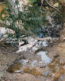
Photograph (Item) - Print, Craig Price, Trees, Water And Beer Bottles - River Bank Eltham, 1988
... It is a time capsule of life in the 1980s of this urban and rural municipality in Melbourne's north. shire of eltham archives Bicentennial Project Eltham Eltham Community Photographic Survey Eltham Photographic Survey Exhibition Series 34 Series 35 Craig Price Yarra River Front: Entrant No. and name on printed label Rear: Entrant No., name and address on printed label; also 'Series 34' and the 'Item No.' in pencil Colour print 20.5 x 25.5 cm mounted on card 25.4 x 30.4 cm Trees, Water And Beer Bottles - River Bank Eltham Photograph Print Craig Price ...Craig Price 1988 Entrant No. 148 Ref: Series 34, Items 37, 38, 109, 110 No negative (or missing) SHIRE OF ELTHAM COMMUNITY PHOTOGRAPHIC SURVEY Photography is an artform which many of us practice, sometimes purely for artistic pursuit, sometimes to record the people and events in our lives. In 1988, as part of a local Bicentennial project, the Shire of Eltham conducted the Eltham Community Photographic Survey. Up to 100 entries were to be selected by a panel of photographers for entry into the Eltham Photographic Survey Exhibition. Entries had to be submitted by May 13, 1988. Entrants whose images were selected for the exhibition were contacted and requested to further submit an entry form providing entrant’s name, area of residence, age, and proposed captions. These details were then used to produce labels for the exhibition mounts. Where negatives had not been supplied, these were requested to support the display of printed enlargements mounted on 10” x 8” cardboard. The mounted prints were made available post exhibition for sale at $8.50 each for colour prints and $7.00 for B&W prints. Residents in the Shire were invited to collect a free roll of film and take a photograph of what they either liked or did not like about the area. A total of 160 entrants submitted multiple entries for the exhibition. Of those selected for exhibition, entrants ranged in age from 9 to 70 years. All custom colour and black and white printing for the exhibition was completed by Wattle Studios of Eltham. The Eltham Photographic Survey was jointly auspiced by the Shire of Eltham and Wattle Studios, of 953 Main Road, Eltham. The project was greatly assisted by: • David McRitchie, Media Studies Lecturer Victoria College, Rusden Campus. • Ian and Annette Toohill of Wattle Studios • Tracy Naughton, Eltham Community Arts Officer • Neville Emerson Pty. Ltd. • Superior Press, Eltham • Kodak Australasia Pty. Ltd. • Agfa Gevaert Ltd. • Townsend Colourtech Pty. Ltd. • The Australian Bicentennial Authority • Eleanor Bowers, Secretary, Eltham Arts Council The exhibition was placed on display in the Woolworths Arcade, Eltham between Monday June 6th and Saturday June 11, 1988. It was also intended to hold the exhibition at a venue in the Shire’s North Riding from Monday, June 20 to Friday June 24. It was then displayed at the Were Street Theatre, Montmorency from Friday, June 24 to Thursday, July 7. Series 34: Eltham Community Photographic Survey 1988 - Prints & Documentation Series consists of 117 photographs of Shire scenes taken by members of the community. Items I - 41 are larger photographs mounted on card, which were exhibited. Items 42 - 117 are unmounted copies, alternative takes and other entries. Corresponding negatives contained in Series 35: Eltham Community Photographic Survey 1988 – Negatives which consists of 267 colour and B&W negatives and one colour slide of Shire scenes taken by members of the community. The negatives are arranged by the entrant number of the photographer. The Eltham Community Photographic Survey collection is significant to the local community as it was curated by the local community - ordinary people of all ages - representing what they liked and did not like in the area where they lived. It represents an unfiltered representation of the Shire of Eltham as it was in 1988. It also represents one of many projects as part of the national programme of events and celebrations to commemorate the bicentenary. It is a time capsule of life in the 1980s of this urban and rural municipality in Melbourne's north. Front: Entrant No. and name on printed label Rear: Entrant No., name and address on printed label; also 'Series 34' and the 'Item No.' in pencilshire of eltham archives, bicentennial project, eltham, eltham community photographic survey, eltham photographic survey exhibition, series 34, series 35, craig price, yarra river -
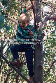 Eltham District Historical Society Inc
Photograph (Item) - Print, Robyn Price, Lots Of Trees For Kids To Climb On In Eltham, 1988
... It is a time capsule of life in the 1980s of this urban and rural municipality in Melbourne's north. shire of eltham archives Bicentennial Project Eltham Eltham Community Photographic Survey Eltham Photographic Survey Exhibition Series 34 Series 35 Robyn Price Film - Fuji 400 Scan - 35mm negative Front: Entrant No. and name on printed label Rear: Entrant No., name and address on printed label; also 'Series 34' and the 'Item No.' in pencil Colour print 20.5 x 25.5 cm mounted on card 25.4 x 30.4 cm Also corresponding negative (Series 35) Digital image scanned from negative (Series 35) Lots Of Trees For Kids To Climb On In Eltham Photograph Print Robyn Price ...Robyn Price 1988 Entrant No. 73 Ref: Series 34, Items 91, 92 SHIRE OF ELTHAM COMMUNITY PHOTOGRAPHIC SURVEY Photography is an artform which many of us practice, sometimes purely for artistic pursuit, sometimes to record the people and events in our lives. In 1988, as part of a local Bicentennial project, the Shire of Eltham conducted the Eltham Community Photographic Survey. Up to 100 entries were to be selected by a panel of photographers for entry into the Eltham Photographic Survey Exhibition. Entries had to be submitted by May 13, 1988. Entrants whose images were selected for the exhibition were contacted and requested to further submit an entry form providing entrant’s name, area of residence, age, and proposed captions. These details were then used to produce labels for the exhibition mounts. Where negatives had not been supplied, these were requested to support the display of printed enlargements mounted on 10” x 8” cardboard. The mounted prints were made available post exhibition for sale at $8.50 each for colour prints and $7.00 for B&W prints. Residents in the Shire were invited to collect a free roll of film and take a photograph of what they either liked or did not like about the area. A total of 160 entrants submitted multiple entries for the exhibition. Of those selected for exhibition, entrants ranged in age from 9 to 70 years. All custom colour and black and white printing for the exhibition was completed by Wattle Studios of Eltham. The Eltham Photographic Survey was jointly auspiced by the Shire of Eltham and Wattle Studios, of 953 Main Road, Eltham. The project was greatly assisted by: • David McRitchie, Media Studies Lecturer Victoria College, Rusden Campus. • Ian and Annette Toohill of Wattle Studios • Tracy Naughton, Eltham Community Arts Officer • Neville Emerson Pty. Ltd. • Superior Press, Eltham • Kodak Australasia Pty. Ltd. • Agfa Gevaert Ltd. • Townsend Colourtech Pty. Ltd. • The Australian Bicentennial Authority • Eleanor Bowers, Secretary, Eltham Arts Council The exhibition was placed on display in the Woolworths Arcade, Eltham between Monday June 6th and Saturday June 11, 1988. It was also intended to hold the exhibition at a venue in the Shire’s North Riding from Monday, June 20 to Friday June 24. It was then displayed at the Were Street Theatre, Montmorency from Friday, June 24 to Thursday, July 7. Series 34: Eltham Community Photographic Survey 1988 - Prints & Documentation Series consists of 117 photographs of Shire scenes taken by members of the community. Items I - 41 are larger photographs mounted on card, which were exhibited. Items 42 - 117 are unmounted copies, alternative takes and other entries. Corresponding negatives contained in Series 35: Eltham Community Photographic Survey 1988 – Negatives which consists of 267 colour and B&W negatives and one colour slide of Shire scenes taken by members of the community. The negatives are arranged by the entrant number of the photographer. The Eltham Community Photographic Survey collection is significant to the local community as it was curated by the local community - ordinary people of all ages - representing what they liked and did not like in the area where they lived. It represents an unfiltered representation of the Shire of Eltham as it was in 1988. It also represents one of many projects as part of the national programme of events and celebrations to commemorate the bicentenary. It is a time capsule of life in the 1980s of this urban and rural municipality in Melbourne's north. Front: Entrant No. and name on printed label Rear: Entrant No., name and address on printed label; also 'Series 34' and the 'Item No.' in pencilshire of eltham archives, bicentennial project, eltham, eltham community photographic survey, eltham photographic survey exhibition, series 34, series 35, robyn price, film - fuji 400, scan - 35mm negative