Showing 24 items matching "tullaroop"
-
 Ringwood and District Historical Society
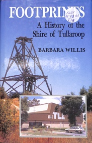
Book, Footprints - History of the Shire of Tullaroop
... Footprints - History of the Shire of Tullaroop...History of the Shire of Tullaroop...Ringwood and District Historical Society 125A Warrandyte Road Ringwood North melbourne History of the Shire of Tullaroop Footprints - History of the Shire of Tullaroop Book Barbara Willis ...History of the Shire of Tullaroop -
 Clunes Museum
Photograph
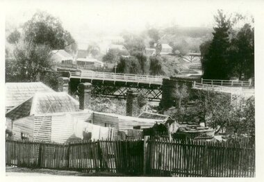
... SEPIA PHOTOGRAPH OF GOVERNMENT BRIDGE OVER TULLAROOP CREEK, CLUNES....BRIDGE OVER TULLAROOP CREEK, CLUNES. PUBLISHED BY E. BARNETT, M5124 [FOR REVERSE - SEE OVER]...Clunes Museum 36 Fraser Street enter building through Collins Place Clunes goldfields local history photography photographs bridges BRIDGE OVER TULLAROOP CREEK, CLUNES. PUBLISHED BY E. BARNETT, M5124 [FOR REVERSE - SEE OVER] SEPIA PHOTOGRAPH OF GOVERNMENT BRIDGE OVER TULLAROOP CREEK, CLUNES. ...SEPIA PHOTOGRAPH OF GOVERNMENT BRIDGE OVER TULLAROOP CREEK, CLUNES.BRIDGE OVER TULLAROOP CREEK, CLUNES. PUBLISHED BY E. BARNETT, M5124 [FOR REVERSE - SEE OVER]local history, photography, photographs, bridges -
 Clunes Museum
Photograph
... PHOTOGRAPH TAKEN LOOKING DOWNSTREAM TULLAROOP CREEK, ABOUT 1900. GOVERNMENT BRIDGE IN FOREGROUND, JULILEE BRIDGE IN MIDDLE DISTANCE, PORT PHILLIP MINE POPPET HED IN DISTANCE....IN HANDWRITING : LOOKING DOWN-STREAM TULLAROOP CREEKABOUT 1900 GOVERMENT BRIDGE IN FOREGROUND JUBILEE BRIDGE IN THE MIDDLE...Clunes Museum 36 Fraser Street enter building through Collins Place Clunes goldfields PHOTOGRAPH TAKEN LOOKING DOWNSTREAM TULLAROOP CREEK, ABOUT 1900. GOVERNMENT BRIDGE IN FOREGROUND, JULILEE BRIDGE IN MIDDLE DISTANCE, PORT PHILLIP MINE POPPET HED IN DISTANCE. bridges JUBILEE BRIDGE GOVERMENT BRIDGE IN HANDWRITING : LOOKING DOWN-STREAM TULLAROOP CREEKABOUT 1900 GOVERMENT BRIDGE IN FOREGROUND JUBILEE BRIDGE IN THE MIDDLE .1 ORIGINAL PHOTOGRAPH OF GOVERNMENT BRIDGE AND JUBILEE BRIDGE. ...PHOTOGRAPH TAKEN LOOKING DOWNSTREAM TULLAROOP CREEK, ABOUT 1900. GOVERNMENT BRIDGE IN FOREGROUND, JULILEE BRIDGE IN MIDDLE DISTANCE, PORT PHILLIP MINE POPPET HED IN DISTANCE..1 ORIGINAL PHOTOGRAPH OF GOVERNMENT BRIDGE AND JUBILEE BRIDGE. TAKEN FROM CREEK PARADE. THE GOVERNMENT BRIDGE WAS BUILT CIRCA 1900. .2 ENLARGED PHOTOCOPY IN HANDWRITING : LOOKING DOWN-STREAM TULLAROOP CREEKABOUT 1900 GOVERMENT BRIDGE IN FOREGROUND JUBILEE BRIDGE IN THE MIDDLEbridges, jubilee bridge, goverment bridge -
 Clunes Museum
Photograph, BAWDEN PHOTOGRAPHER, CIRCA 1890
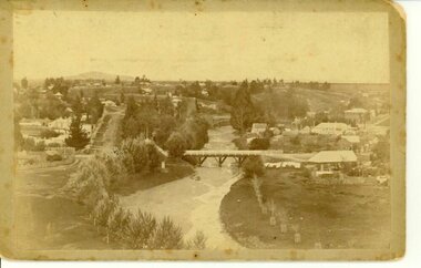
... TULLAROOP CREEK FROM "ROCKS" NEAR SITE OF PORT PHILLIP MINE. ...ORIGINAL SEPIA PHOTOGRAPH OF TULLAROOP CREEK, IN FOREGROUND VIEWS OF CLUNES TOWNSHIP. ...Clunes Museum 36 Fraser Street enter building through Collins Place Clunes goldfields TULLAROOP CREEK FROM "ROCKS" NEAR SITE OF PORT PHILLIP MINE. ...TULLAROOP CREEK FROM "ROCKS" NEAR SITE OF PORT PHILLIP MINE. ABOUT 1890 - NOTE GOVERNMENT BRIDGE IN DISTANCE. THIS WAS REBUILT IN STRAIGHT STEEL GIRDERS IN 1896.ORIGINAL SEPIA PHOTOGRAPH OF TULLAROOP CREEK, IN FOREGROUND VIEWS OF CLUNES TOWNSHIP. TWO MILE HILL IN LEFT FAR DISTANCE. (SUSPENSION BRIDGE IN FOREGROUND)local history, photography, bridges - buildings and landscape of clunes -
 Clunes Museum
Booklet, THE VICTORIAN TOURISM COMMISSION, BLUESTONE & LACE
... ...TULLAROOP...INCLUDES A CALENDAR OF EVENTS FOR TOURISM ACTIVITIES IN MARYBOROUGH REGION INCLUDING SHIRES OF AVOCA, BET BET, TALBOT & CLUNES, TULLAROOP AND CITY OF MARYBOROUGH....Clunes Museum 36 Fraser Street enter building through Collins Place Clunes goldfields MARYBOROUGH REGION TOURIST INFORMATION AVOCA BET BET TALBOT & CLUNES TULLAROOP 20 PAGE COLOURED BOOKLET "BLUESTONE & LACE". ...20 PAGE COLOURED BOOKLET "BLUESTONE & LACE". MARYBOROUGH REGION VICTORIA. INCLUDES A CALENDAR OF EVENTS FOR TOURISM ACTIVITIES IN MARYBOROUGH REGION INCLUDING SHIRES OF AVOCA, BET BET, TALBOT & CLUNES, TULLAROOP AND CITY OF MARYBOROUGH.maryborough region, tourist information, avoca, bet bet, talbot & clunes, tullaroop -
 Clunes Museum
Photograph
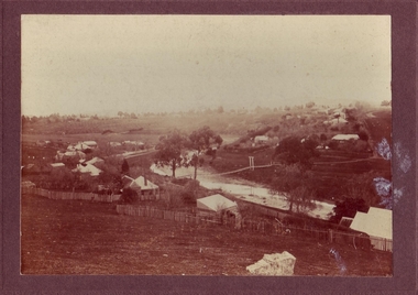
... PHOTOGRAPH OF CLUNES SHOWING TULLAROOP CREEK...Clunes Museum 36 Fraser Street enter building through Collins Place Clunes goldfields local history photography photographs clunes township TO HANNAH & DUNAL XMAS GREETINGS 1956 TOM PAYNE PHOTOGRAPH OF CLUNES SHOWING TULLAROOP CREEK Photograph PHOTOGRAPH ...PHOTOGRAPH OF CLUNES SHOWING TULLAROOP CREEKTO HANNAH & DUNAL XMAS GREETINGS 1956 TOM PAYNElocal history, photography, photographs, clunes township -
 Clunes Museum
Photograph
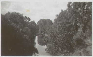
... VIEW OF THE CREEK AT CLUNES (CRESWICK CREEK - TULLAROOP)...Clunes Museum 36 Fraser Street enter building through Collins Place Clunes goldfields local history photography photographs clunes landscape THE CREEK AT CLUNES VIEW OF THE CREEK AT CLUNES (CRESWICK CREEK - TULLAROOP) Photograph PHOTOGRAPH ...VIEW OF THE CREEK AT CLUNES (CRESWICK CREEK - TULLAROOP)THE CREEK AT CLUNESlocal history, photography, photographs, clunes, landscape -
 Clunes Museum
Photograph, CIRCA 1880
... BLACK AND WHITE PHOTOGRAPH OF THE SUSPENSION BRIDGE OVER TULLAROOP CREEK, CLUNES....BLACK AND WHITE PHOTOGRAPH OF THE SUSPENSION BRIDGE OVER TULLAROOP CREEK, CLUNES. Photograph PHOTOGRAPH ...BLACK AND WHITE PHOTOGRAPH OF THE SUSPENSION BRIDGE OVER TULLAROOP CREEK, CLUNES.CLUNES 1880.local history, photography, photographs, bridges -
 Clunes Museum
Photograph, FOOT BRIDGE, CIRCA 1920
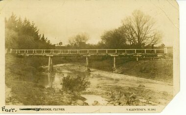
... POST CARD PHOTOGRAPH OF FOOTBRIDGE IN CLUNES OVER TULLAROOP CREEK. TAKEN ABOUT 1920....VALENTINES M 5982 POST CARD PHOTOGRAPH OF FOOTBRIDGE IN CLUNES OVER TULLAROOP CREEK. TAKEN ABOUT 1920. FOOT BRIDGE Photograph PHOTOGRAPH ...POST CARD PHOTOGRAPH OF FOOTBRIDGE IN CLUNES OVER TULLAROOP CREEK. TAKEN ABOUT 1920.FOOT BRIDGE CLUNES. VALENTINES M 5982local history, photographs, bridges, foot bridge -
 Clunes Museum
Newspaper - VISITOR'S GUIDE 1992, ADVERTISER PRINTING WORKS, 1992
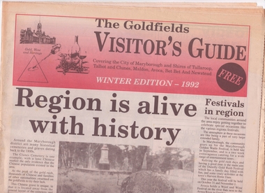
... THE GOLDFIELD'S VISITOR'S GUIDE WINTER EDITION - 1992 COVERING THE CITY OF MARYBOROUGH, SHIRES OF TULLAROOP, TALBOT AND CLUNES, MALDON, AVOCA, BET BET AND NEWSTEAD...Clunes Museum 36 Fraser Street enter building through Collins Place Clunes goldfields TO ADVERTISE THE GOLDFIELDS IN VICTORIA local history documents newspaper visitor's guide THE GOLDFIELD'S VISITOR'S GUIDE WINTER EDITION - 1992 COVERING THE CITY OF MARYBOROUGH, SHIRES OF TULLAROOP, TALBOT AND CLUNES, MALDON, AVOCA, BET BET AND NEWSTEAD Newspaper VISITOR'S GUIDE 1992 ADVERTISER PRINTING WORKS BALLARAT COURIER PTY. ...TO ADVERTISE THE GOLDFIELDS IN VICTORIATHE GOLDFIELD'S VISITOR'S GUIDE WINTER EDITION - 1992 COVERING THE CITY OF MARYBOROUGH, SHIRES OF TULLAROOP, TALBOT AND CLUNES, MALDON, AVOCA, BET BET AND NEWSTEADlocal history, documents, newspaper, visitor's guide -
 Clunes Museum
Photograph, CIRCA 1880
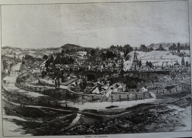
... TREE GUARDS AROUND TREES ALONG CREEK BANK, ORIGINAL NAMED TULLAROOP CREEK....TREE GUARDS AROUND TREES ALONG CREEK BANK, ORIGINAL NAMED TULLAROOP CREEK. local history photography photographs clunes township. ...AN ETCHING OF VERY EARLY CLUNES. TREE GUARDS AROUND TREES ALONG CREEK BANK, ORIGINAL NAMED TULLAROOP CREEK.CLUNES TOWNSHIP, CRESWICK CREEK, DOUBLE STORY BUILDINGS AND MINE POPPET HEADS.TOWN OF CLUNESlocal history, photography, photographs, clunes township. -
Clunes Museum
Booklet, JACOBS & MACKAY PTY.LTD - "ADVERTISER" PRINT, COMMEMORATION OF TWENTY-NINTH YEAR OF GIRL GUIDING, 1940
... N.A.BUCKNALL, PRESIDENT OF SHIRE OF TULLAROOP....N.A.BUCKNALL, PRESIDENT OF SHIRE OF TULLAROOP. LOCAL HISTORY DOCUMENTS MEMORIALS & ADDRESSES BOY SCOUTS GIRL GUIDES BROWNIES. ...HELD ON SATURDAY 12 TH OCTOBER 1940 AT 3PM IN THE SHIRE HALL, CARISBROOK. CHAIRMAN CR. N.A.BUCKNALL, PRESIDENT OF SHIRE OF TULLAROOP.ORDER OF SERVICE FOR COMMEMORATION OF TWENTY-NINTH OF GIRL GUIDING IN CARISBROOK, CLUNES,MARYBOROUGH, DAYLESFORD. LEARMONTH, WAUBRA AND SMEATON DIVISION - PRINTED ON BUFF COLURED PAPERlocal history, documents memorials & addresses, boy scouts, girl guides, brownies. -
 Clunes Museum
Photograph, APPROX. 1900
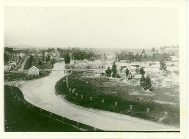
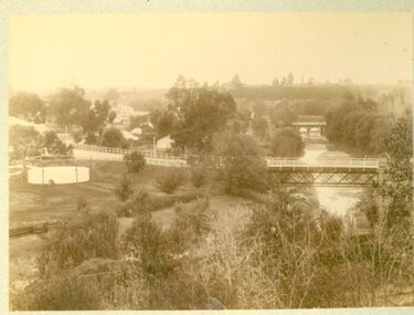
... THE PHOTOGRAPH WAS TAKEN FROM CREEK PARADE GOVERNMENT BRIDGE CRESWICK ROAD AND BUTTER FACTORY BRIDGE ACROSS TULLAROOP CREEK. GASWORKS....Clunes Museum 36 Fraser Street enter building through Collins Place Clunes goldfields THE PHOTOGRAPH WAS TAKEN FROM CREEK PARADE GOVERNMENT BRIDGE CRESWICK ROAD AND BUTTER FACTORY BRIDGE ACROSS TULLAROOP CREEK. GASWORKS. local history photography photographs bridges and buildings .1 ON BACK OF PHOTOGRAPH GASWORKS, BRIDGES AND CREEK. 1900 .3 ON FRONT OF POSTCARD GOV. ...THE PHOTOGRAPH WAS TAKEN FROM CREEK PARADE GOVERNMENT BRIDGE CRESWICK ROAD AND BUTTER FACTORY BRIDGE ACROSS TULLAROOP CREEK. GASWORKS..1 ORIGINAL SEPIA LANDSCAPE OF CLUNES MOUNTED ON CARDBOARD. GOVERNMENT AND JUBILEE BRIDGES ACROSS CRESWICK CREEK. GASWORKS NEARBY. .2 BLACK AND WHITE COPY OF THE ABOVE PHOTOGRAPH PRINTED ON GLOSS PHOTOGRAPHIC PAPER .3 HAND COLOURED POSTCARD PHOTOGRAPH OF THE ABOVE PHOTOGRAPH .4 TWO POSTCARDS WITH SAME PICTURE .5 FOUR SMALL PHOTOGRAPH COPIES WITH SAME PICTURE.1 ON BACK OF PHOTOGRAPH GASWORKS, BRIDGES AND CREEK. 1900 .3 ON FRONT OF POSTCARD GOV. BRIDGE CLUNESlocal history, photography, photographs, bridges and buildings -
 Clunes Museum
Photograph
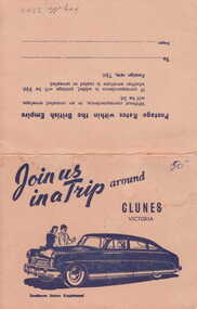
... OLD POST OFFICE 4. TULLAROOP RIVER CLUNES 5. 2 OF FRASER STREET, CLUNES...OLD POST OFFICE 4. TULLAROOP RIVER CLUNES 5. 2 OF FRASER STREET, CLUNES Photograph PHOTOGRAPH ...PICTURESQUE SOUVENIR OF CLUNES. A FOLDER OF 8 PHOTOS CONSISTING OF VIEWS OF CLUNES 1. 3 PANORAMAS 2. CLUNES HOSPITAL 3. OLD POST OFFICE 4. TULLAROOP RIVER CLUNES 5. 2 OF FRASER STREET, CLUNESJOIN US IN A TRIP AROUND CLUNESlocal history, photography, photographs, township & buildings -
Federation University Historical Collection
Book, Historic Sites Survey: North Central Study Area, 1979, 1979
... The North Central Study Area included the Shires of Avoca, Bet Bet, east Loddon, Goulburn, Untly, Kara Kara, Korong, Maldon, Marong, Metcalfe, McIvor, Newstead, Strathfieldsaye, Stawell, Talbot, Clunes, Tullaroop and Waranga. ...Barker Library (top floor) Mount Helen goldfields The North Central Study Area included the Shires of Avoca, Bet Bet, east Loddon, Goulburn, Untly, Kara Kara, Korong, Maldon, Marong, Metcalfe, McIvor, Newstead, Strathfieldsaye, Stawell, Talbot, Clunes, Tullaroop and Waranga. castlemaine mount alexander goldfield maldon percydale warrenmang moliagul tarnagulla stuart mill the whipstick whroo rushworth graytown ironbark forest st arnoaud new bendigo landsborough inglewood kurting wedderburn wehla kooroora langham flat mcintyre rheola diamond hill fosterville coliban water works green gully newstead muckleford forest costerfield graytown bailieston waranga irrigaiton system eucalyptus distillery mia mia bridge korokubeal township researce concegella slate quarry chewton fryerstown kingower timor talbot majorca carisbroook clunes st arnaud taradale icomos dunolly limestone castlemaine slate quarry harcourt granite taradale railway viaduct loddon united waterworks trust gouldburn weir carisbrook lock-up history of tree planting in streets history of public reserves r.u. nicholls nurseryman thomas lang francis moss ballarat botanical gardens ballarat school of mines botanical gardens lake wendouree victoria park, ballarat muont holled smith ballaarat old cemetery planting eastern oval ballarat east botanical gardens ballarat east town hall gardens eureka stockade reserve ballarat observatory plantings yarrowee creek plantings yarrowee bluestone channels ballarat woollen mill band and albion mullock heap black hill plantings yarrowee creek channels canadian creek channel specimen vale channel poverty point reserve union jack reserve buninyong imperial mine, buninyong victoria street plantings bridge mall sturt street gardens ballarat avenue of honour plantings white flat oval plantings camp street elms burnt creek 153 page book with white plastic binding. ...The North Central Study Area included the Shires of Avoca, Bet Bet, east Loddon, Goulburn, Untly, Kara Kara, Korong, Maldon, Marong, Metcalfe, McIvor, Newstead, Strathfieldsaye, Stawell, Talbot, Clunes, Tullaroop and Waranga. 153 page book with white plastic binding. It is an historic sites survey for the North Central Study Area commissioned by the Land Conservation Council, the Ministry for COnservation and the Australian Heritage Commission. castlemaine, mount alexander goldfield, maldon, percydale, warrenmang, moliagul, tarnagulla, stuart mill, the whipstick, whroo, rushworth, graytown ironbark forest, st arnoaud, new bendigo, landsborough, inglewood, kurting, wedderburn, wehla, kooroora, langham flat, mcintyre, rheola, diamond hill, fosterville, coliban water works, green gully, newstead, muckleford forest, costerfield, graytown, bailieston, waranga irrigaiton system, eucalyptus distillery, mia mia bridge, korokubeal township researce, concegella slate quarry, chewton, fryerstown, kingower, timor, talbot, majorca, carisbroook, clunes, st arnaud, taradale, icomos, dunolly, limestone, castlemaine slate quarry, harcourt granite, taradale railway viaduct, loddon united waterworks trust, gouldburn weir, carisbrook lock-up, history of tree planting in streets, history of public reserves, r.u. nicholls nurseryman, thomas lang, francis moss, ballarat botanical gardens, ballarat school of mines botanical gardens, lake wendouree, victoria park, ballarat, muont holled smith, ballaarat old cemetery planting, eastern oval, ballarat east botanical gardens, ballarat east town hall gardens, eureka stockade reserve, ballarat observatory plantings, yarrowee creek plantings, yarrowee bluestone channels, ballarat woollen mill, band and albion mullock heap, black hill plantings, yarrowee creek channels, canadian creek channel, specimen vale channel, poverty point reserve, union jack reserve buninyong, imperial mine, buninyong, victoria street plantings, bridge mall, sturt street gardens, ballarat avenue of honour plantings, white flat oval plantings, camp street, elms, burnt creek -
Tatura Irrigation & Wartime Camps Museum
Photograph, Goulburn Irrigation System, 1970s
... Map showing the Goulburn Irrigation System in Northern Victoria including Eildon Reservoir, Waranga Reservoir, Eppalock Reservoir, Eppalock, Cairn Curran, Laancoorie, Tullaroop Reservoirs, the Stuart Murray, Cattanach Canal, East Goulburn Main and Waranga Western Channels....Map showing the Goulburn Irrigation System in Northern Victoria including Eildon Reservoir, Waranga Reservoir, Eppalock Reservoir, Eppalock, Cairn Curran, Laancoorie, Tullaroop Reservoirs, the Stuart Murray, Cattanach Canal, East Goulburn Main and Waranga Western Channels. ...Taken by photographer for State Rivers and Water Supply Commission.Medium sized black and white photograph. Map showing the Goulburn Irrigation System in Northern Victoria including Eildon Reservoir, Waranga Reservoir, Eppalock Reservoir, Eppalock, Cairn Curran, Laancoorie, Tullaroop Reservoirs, the Stuart Murray, Cattanach Canal, East Goulburn Main and Waranga Western Channels.goulburn weir, victorian state rivers and supply commission -
 Clunes Museum
Photograph - PHOTOGRAPHS, THE VALENTINE PUBLISHING CO. PTY. LTD
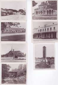
... 2 VIEWS OF CLUNES TOWN HALL 1 VIEWS OF DISTRICT HOSPITAL, CLUNES 2 VIEWS OF FRASER STREET, CLUNES 2 VIEWS OF CLUB HOTEL, CLUNES 1 VIEW OF GOLD MONUMENT 1 VIEW OF TULLAROOP RIVER, CLUNES 1 VIEW OF INTERNET HOSIERY CO. ...Clunes Museum 36 Fraser Street enter building through Collins Place Clunes goldfields 2 VIEWS OF CLUNES TOWN HALL 1 VIEWS OF DISTRICT HOSPITAL, CLUNES 2 VIEWS OF FRASER STREET, CLUNES 2 VIEWS OF CLUB HOTEL, CLUNES 1 VIEW OF GOLD MONUMENT 1 VIEW OF TULLAROOP RIVER, CLUNES 1 VIEW OF INTERNET HOSIERY CO. ...2 VIEWS OF CLUNES TOWN HALL 1 VIEWS OF DISTRICT HOSPITAL, CLUNES 2 VIEWS OF FRASER STREET, CLUNES 2 VIEWS OF CLUB HOTEL, CLUNES 1 VIEW OF GOLD MONUMENT 1 VIEW OF TULLAROOP RIVER, CLUNES 1 VIEW OF INTERNET HOSIERY CO. CLUNES. (FORMERLY SOUTH CLUNES SCHOOL)SMALL MANILLA ENVELOPE CONTAINING TEN PHOTOGRAPHS - TOWN HALL CLUNES, DISTRICT HOSPITAL CLUNES, FRASER STREET CLUNES, CLUB HOTEL CLUNES, INTERKNIT HOSIERY COY. LTD. CLUNES, MONUMENT AT CLUNES, TALLAROOP RIVER CLUNESPrinted on envelope in blue ink; Valentine's Snapshots, Eight Real Photographs, Clunes. Published by The Valentine Publishing Co. Pty. Ltd. Melbourne, Sydney and Adelaidelocal history, photography, photographs -
 Bendigo Military Museum
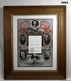
Certificate - SHIRE OF TULLAROOP, FRAMED, Post WW1
... Certificate of Appreciation by the Citizens of the Shire of Tullaroop to Pte John S Howlett No 2676 59th Battalion AIF 1914-5-6. ...Certificate SHIRE OF TULLAROOP, FRAMED Atlas Press Pty Ltd Atlas Press Pty Ltd ...Item relates to John Stanley HOWLETT No 2676 AIF. Refer Cat No 41 for his service history.Certificate of Appreciation by the Citizens of the Shire of Tullaroop to Pte John S Howlett No 2676 59th Battalion AIF 1914-5-6. Black & white certificate with red and white flags at top. 6 x dignitaries of the day are pictured. White border mounted, glass front, timber frame with gold inner border & ply backing.certificates, framed, shire -
 Federation University Historical Collection
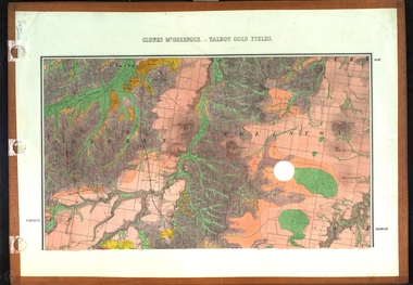
Map, Clunes, Mt Greenock, and Talbot Gold Fields, 1883, 1883
... A geological plan of the Clunes, Mt Greenock, and Talbot Gold Fields in two parts. .1) This section of the map includes Talbot, Talbot water supply race, Mt Glasgow, Little Green Hill, Middle Hill, Mt Cameron, Ballarat Hill, Bakery Hill, Goodwoman Hill, Scandanavian Lead, Eglinton Swamp, McCallum's Creek, Tullaroop Creek, Dunach, Maryborough Railway, Middle Creek and includes many mines such as Rip Van Winkel, Union Extended, South Greenock, Nicholl's Freehold. .2) This section of the map includes McCallums, Clunes, Green Hill, Mt Beckworth, Mt Gap, Maryborough Reservoir, and includes mines such as Lothair, Bute, Clyde, Clunes Consols, London and Australian, Oriental,...Barker Library (top floor) Mount Helen goldfields clunes talbot water supply railway geology A geological plan of the Clunes, Mt Greenock, and Talbot Gold Fields in two parts. .1) This section of the map includes Talbot, Talbot water supply race, Mt Glasgow, Little Green Hill, Middle Hill, Mt Cameron, Ballarat Hill, Bakery Hill, Goodwoman Hill, Scandanavian Lead, Eglinton Swamp, McCallum's Creek, Tullaroop Creek, Dunach, Maryborough Railway, Middle Creek and includes many mines such as Rip Van Winkel, Union Extended, South Greenock, Nicholl's Freehold. .2) This section of the map includes McCallums, Clunes, Green Hill, Mt Beckworth, Mt Gap, Maryborough Reservoir, and includes mines such as Lothair, Bute, Clyde, Clunes Consols, London and Australian, Oriental, Clunes, Mt Greenock, and Talbot Gold Fields, 1883 Map Map J. ...A geological plan of the Clunes, Mt Greenock, and Talbot Gold Fields in two parts. .1) This section of the map includes Talbot, Talbot water supply race, Mt Glasgow, Little Green Hill, Middle Hill, Mt Cameron, Ballarat Hill, Bakery Hill, Goodwoman Hill, Scandanavian Lead, Eglinton Swamp, McCallum's Creek, Tullaroop Creek, Dunach, Maryborough Railway, Middle Creek and includes many mines such as Rip Van Winkel, Union Extended, South Greenock, Nicholl's Freehold. .2) This section of the map includes McCallums, Clunes, Green Hill, Mt Beckworth, Mt Gap, Maryborough Reservoir, and includes mines such as Lothair, Bute, Clyde, Clunes Consols, London and Australian, Oriental,clunes, talbot, water supply, railway, geology -
 Bendigo Historical Society Inc.
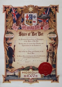
Certificate - Jack Lockett Collection: Shire of Bet Bet Great War Certificate, D. W. Paterson Co. Pty. Ltd. 495 Collins St. Melbourne, 1921
... On 20 January 1995, the Shire of Bet Bet was abolished, and along with the City of Maryborough, the Shire of Tullaroop , was merged into the newly created Shire of Central Goldfields. ...On 20 January 1995, the Shire of Bet Bet was abolished, and along with the City of Maryborough, the Shire of Tullaroop , was merged into the newly created Shire of Central Goldfields. ...John Henry Lockett OAM (22 January 1891 – 25 May 2002) was the oldest man ever in Australia when he died aged 111 years, 123 days. As one of the last surviving veterans of World War I, he was acclaimed as a national hero during the last decade of his life. Lockett was born in the small Victorian town of Waanyarra, near Bendigo. He left school aged nine to work on a local farm. Later, he worked for his uncles in the Mallee. On 24 March 1916, he travelled to Mildura to enlist in the Australian Imperial Force. He served in France with the 38th Battalion, earning promotion to sergeant and was discharged on 20 September 1919. https://en.wikipedia.org/wiki/Jack_Lockett After the war, Jack returned to The Mallee and selected a 640 acres (260 ha) block of land in Linga, Victoria, deciding to make his living as a farmer. In 1923, he married Maybell Ingwerson and they had four children together. In 1963, the couple retired to Bendigo, leaving the farmland (which now covered more than 130,000 acres (53,000 ha), in the care of their children and grandchildren. Bet Bet became a shire in 1864 with Dunolly in its centre. On 20 January 1995, the Shire of Bet Bet was abolished, and along with the City of Maryborough, the Shire of Tullaroop , was merged into the newly created Shire of Central Goldfields. D. W. Paterson Co 1907?- 1961Winfield Building, 495 Collins Street, Melbourne, Victoria, Australia A coloured certificate on white paper from the Shire of Bet Bet for service in the first World War. An Australian Coat of arms at the top with 1914 THE GREAT WAR 1919 Printed and handwritten underneath between an image of a sailor and a soldier FREEDOM Shire of Bet Bet JUSTICE The President, Councilors, and Ratepayers of the Shire of Bet Bet hearby place on record Thanks and Appreciation for the Conduct of J Lockett who served his King and Country in the Great War. In Witness Whereof the Corporate Seal of the Municipality is hereto attached in the presence of Arthur Green President H E Clancy Secretary. Dated 4 AUG 1921 HONOUR TO THE BRAVE D. W. PATERSON CO. PTY. LTD. 495 COLLINS ST. MELB. a jack lockett, mabel ingwersen, world war 1, france, 38th battalion, shire of bet bet, d. w. paterson co. -
Federation University Historical Collection
Booklet, Ballarat School of Mines, Regional Unemployment: Ballarat School of Mines Planning Document 7:79, 02/1979
... ...tullaroop...Barker Library (top floor) Mount Helen goldfields unempolyment ballarat school of mines ballarat horsham ararat mildura maryborough tullaroop creswick clunes talbot st arnaud bacchus marsh bet bet kara kara bungaree buninyong ballan dunmunkle stawell dimboola lowan kaniva kowree White cardboard cover with black plastic spine Regional Unemployment: Ballarat School of Mines Planning Document 7:79 Booklet Booklet Ballarat School of Mines ...White cardboard cover with black plastic spineunempolyment, ballarat school of mines, ballarat, horsham, ararat, mildura, maryborough, tullaroop, creswick, clunes, talbot, st arnaud, bacchus marsh, bet bet, kara kara, bungaree, buninyong, ballan, dunmunkle, stawell, dimboola, lowan, kaniva, kowree -
Federation University Historical Collection
Book, Wimmera Regional College Steering Committee, Wimmera Community College Study, 1977 and Ballarat TAFE Study, 1977, 09/1977
... ...tullaroop...Mallee wimmera harrow horsham dimboola murtoa minyip warracknabeal stawell nhill kaniva goroke jeparit hopetoun rainbow edenhope garoke rainbow rupanyup ballarat TAFE community education market research avoca ballarat ballan bet bet bungaree buninyong creswick daylesford glenlyon st arnaud talbot clunes tullaroop Two green soft covered volumes with plastic ring binding. .1) Wimmera Community College Study. ...The Wimmera Region used in the sample included the elctoral division of Wannon, Wimmera and Mallee.Two green soft covered volumes with plastic ring binding. .1) Wimmera Community College Study. Contents include the Wimmera Region, courses, vocational courses, leisure courses. .2) Ballarat TAFE Study. Contents Include aspiratons, community awareness, courses, employment, industry needs, mallee, wimmera, harrow, horsham, dimboola, murtoa, minyip, warracknabeal, stawell, nhill, kaniva, goroke, jeparit, hopetoun, rainbow, edenhope, garoke, rainbow, rupanyup, ballarat tafe, community education, market research, avoca, ballarat, ballan, bet bet, bungaree, buninyong, creswick, daylesford, glenlyon, st arnaud, talbot, clunes, tullaroop -
 Bendigo Historical Society Inc.
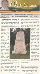
Newspaper - Newspaper articles by Ken Arnold, Out &About, 2000 - 2003
... Historic Church. Near Tullaroop reservoir 12.1.01 27. Granite Statue. ...Historic Church. Near Tullaroop reservoir 12.1.01 27. Granite Statue. ...Ken Arnold is a Bendigo author and publisher.A series of one hundred and thirty-five articles written by Ken Arnold and published in the Bendigo Weekly between 2000 and 2003. Each article has a topic or theme and includes historical information and details. Each article includes a photograph. The articles are stored in a red vinyl covered two ring A5 folder. Index below. Number Article Name Date 1. Centenary of Victoria 19.5.00 2. Storm Water Drain 26.5.00 3. Granite Rollers 2.6.00 4. Poverty Mine 9.6.00 5. Golden Monument. St Arnaud 16.6.00 6. Turner Statue 7.7.00 7. Gold Monument. High St Golden Square 30.6.00 8. Gold Monument. Howard Square Bendigo 14.7.00 9. Lansell Statue 21.7.00 10. Shelbourne West School 18.8.00 11. Mologa’s State Schools 25.8.00 12. Salinity Stone. Pyramid Hill 1.9.00 13. Cairn. Carisbrook 8.9.00 14. Commemorative Markers. Taradale 15.9.00 15. Burke Monument. Castlemaine 22.9.00 16. Cairn. Harcourt area 29.9.00 17. Cairn Marks Gold Route 6.10.00 18. Volcanic Rock Cairn. Woodstock 13.10.00 19. Garfield Water Wheel 20.10.00 20. Anticline. Castlemaine 27.10.00 21. Lawson Bridge 10.11.00 22. Plaque. Sutton Grange area 17.11.00 23. Memorial Cairn. Maryborough 1.12.00 24. Lonely Grave 8.12.00 25. Moonlight Flat Church 5.1.01 26. Historic Church. Near Tullaroop reservoir 12.1.01 27. Granite Statue. Castlemaine 19.1.01 28. Marker. Near Tullaroop reservoir 25.1.01 29. Church Site. Mologa 2.2.01 30. Church Site. Mologa 9.2.01 31. Plaque. Mologa 16.2.01 32. Mincha School 23.2.01 33. Historic Marker. Mincha 2.3.01 34. Expedition Marker. Pyramid Hill 9.3.01 35. Irrigation Marker. Tragowel 16.3.01 36. Mologa School Sites 23.3.01 37. Cairn. Pyramid Hill 30.3.01 38. Plaque. Pyramid Hill 6.4.01 39. Bristol Hill Lookout Tower. Maryborough 12.4.01 40. Eppalock Reservoir 20.4.01 41. Colbinabbin Cairn 27.4.01 42. Mount Macedon Cross 4.5.01 43. Memorial Gateway. Macedon 11.5.01 44. Cairn. Daylesford 18.5.01 45. Grave. Carlsruhe 25.5.01 46. Water Tower. Elmore 1.6.01 47. State School Site. Glenalbyn 8.6.01 48. Cairn. Kanya 15.6.01 49. Lonely Grave. Wedderburn 22.6.01 50. Church Cairn. Glenalbyn 29.6.01 51. Kamarooka School 6.7.01 52. Granite Marker. Moyston 13.7.01 53. Memorial Park. Kerang 20.7.01 54. Water Plaque. Bears Lagoon 27.7.01 55. Cemetery. Bears Lagoon 3.8.01 56. Race Monument 10.8.01 57. Cairn. Pyalong 17.8.01 58. Cairn. In memory of Edward Parker 24.8.01 59. Mt Macedon 31.8.01 60. Mt Macedon Cairn 7.9.01 61. Expedition Pass. Chewton 14.9.01 62. Granite Archway. St Arnaud 21.9.01 63. Stuart Mill School Site 28.9.01 64. School Site. Beazley’s Bridge 5.10.01 65. Fosterville 12.10.01 66. Barnadown 19.10.01 67. Salisbury School Site 26.10.01 68. Cricket History at Wattle Flat 2.11.01 69. School Site. Waterloo Plains 9.11.01 70. Carapooee School Site 11.01 71. Turkish Gun. Maldon 11.01 72. Kooreh 30.11.01 73. Marnoo East School 7.12.01 74. Bulgana Site 14.12.01 75. Emu School 21.12.01 76. Kooroocheang 4.1.02 77. Church Site. Gre Gre North 11.1.02 78. Carmens Tunnel. Maldon 18.1.02 79. Monument. Maldon 25.1.02 80. Woodfull Plaques. Maldon 1.2.02 81. Carapooee. St Peters Anglican Church 8.2.02 82. Cairn. Kingower 15.2.02 83. Cob & Co Stopover. Rheola 22.2.02 84. Flynn Monument 1.3.02 85. The Welcome Stranger. Moliagul 8.3.02 86. Campbell’s Creek Reserve 15.3.02 87. Mine. Fryerstown 22.3.02 88. Escott Grave. Near Chewton 28.3.02 89. School No 808. Kurting area 5.4.02 90. Graves. Bendigo Creek 10.5.02 91. School. Fish Point, Benjeroop North 17.5.02 92. Old Township. Diggora 24.5.02 93. Diggora West (1) 31.5.02 94. Diggora West (2) 7.6.02 95. School No 2735. Gower East 14.6.02 96. Pannoomilloo 21.6.02 97. Kamarooka Settlement 28.6.02 98. Mincha West State School No 1931 5.7.02 99. Bridges. Arnold 12.7.02 100. Woodvale 19.7.02 101. A Famous Son of Raywood. Jack Donaldson 26.7.02 102. Tandarra Area Schools 2.8.02 103. Dingee 9.8.02 104. Avonmore 30.8.02 105. Myola East School 6.9.02 106. Colbinabbin West 13.9.02 107. Colbinabbin West School 20.9.02 108. Runnymede area 27.9.02 109. Wanalta 4.10.02 110. School Sites. Between Wanalta and Carop 11.10.02 111. Burramboot 18.10.02 112. Kangaroo Chair. 25.10.02 113. Mincha South 1.11.02 114. Woodlands Church 8.11.02 115. School site. Sylvaterre 15.11.02 116. Terrick Terrick 22.11.02 117. Leitchville 29.11.02 118. Pennyweight Cemetery. Castlemaine 6.12.02 119. Mincha Area 13.12.02 120. Musk School 20.12.02 121. Dowie Park. Carisbrook 3.1.03 122. Neereman School Site 10.1.03 123. Bald Rock 17.1.03 124. Sylvaterre School Site 24.1.02 125. Carlsruhe 31.1.02 126. Athenaeum. Maldon 7.2.03 127. School. Mincha West 14.2.03 128. Yarraberb 21.2.03 129. Settlement Marker. Ravenswood Estate 28.2.03 130. Comini Reserve. Ravenswood 7.3.03 131. Ironbark and Gold Track. Whroo 14.3.03 132. Burke and Wills Obelisk. Castlemaine 21.3.03 133. James Cook Statue. Myers St Bendigo 28.3.03 134. St Marys Church. Axedale 4 .4.03 135. Butter Factory Site. Warragamba 11.4.03 events, monuments, historical sites, landmarks -
 Federation University Historical Collection
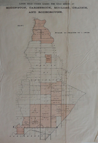
Plan, Lands held under leases for gold mining at Biddington, Carisbrook, Moolort, Craigie and Rodborough, not dated
... Barker Library (top floor) Mount Helen goldfields biddington carisbrook moolort craigie rodborough mining lease d. fitzpatrick m. mullins d. fern kong meng p. mitchell curtain and co a. robertson j. fay chalk's extended Tullaroop Creek mining gold mines Bucknall's Estate Chalk's Estate Printed paper map with red shading Lands held under leases for gold mining at Biddington, Carisbrook, Moolort, Craigie and Rodborough Plan Plan ...Printed paper map with red shadingbiddington, carisbrook, moolort, craigie, rodborough, mining lease, d. fitzpatrick, m. mullins, d. fern, kong meng, p. mitchell, curtain and co, a. robertson, j. fay, chalk's extended, tullaroop creek, mining, gold mines, bucknall's estate, chalk's estate