Showing 32 items matching "tunnel camp"
-
 Nillumbik Historical Society Incorporated
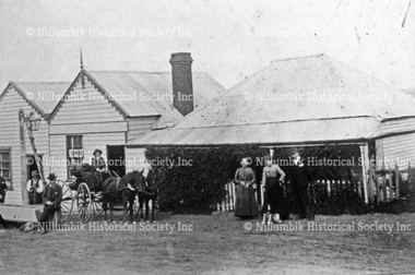
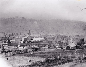
Photograph - Black & white photograph, Pub with Three Names - Evelyn Arms, Tunnel Camp and Halfway House
... Pub with Three Names - Evelyn Arms, Tunnel Camp and Halfway House......tunnel camp...Pub with Three Names - Evelyn Arms, Tunnel Camp and Halfway House Photograph Black & white photograph ...Black and white image of one of Diamond Creek's five original hotels from the 1870's.none#historichotel, #wattsriveraqueduct, tunnel camp, navvies, reservoir, preston -
 Eltham District Historical Society Inc
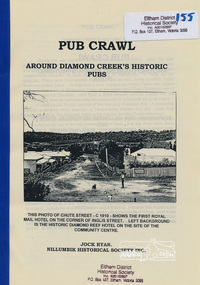
Book, Nillumbik Historical Society, Pub Crawl: around Diamond Creek's historic pubs by Jock Ryan, 2001
... Hotels described include: Evelyn Arms Hotel or Tunnel Camp Hotel or Half-Way House, the Diamond Reef Hotel, the Loyal Diamond Lodge Hotel and the Royal Mail Hotel all located in Diamond Creek during a rapid population growth in Diamond Creek in the 1860s....Eltham District Historical Society Inc 728 Main Rd Eltham melbourne Hotels described include: Evelyn Arms Hotel or Tunnel Camp Hotel or Half-Way House, the Diamond Reef Hotel, the Loyal Diamond Lodge Hotel and the Royal Mail Hotel all located in Diamond Creek during a rapid population growth in Diamond Creek in the 1860s. ...Hotels described include: Evelyn Arms Hotel or Tunnel Camp Hotel or Half-Way House, the Diamond Reef Hotel, the Loyal Diamond Lodge Hotel and the Royal Mail Hotel all located in Diamond Creek during a rapid population growth in Diamond Creek in the 1860s.This small publication discusses the history of local hotels in the Diamond Creek area during a significant period of development in the 1860s when mining took place in the local area. The history of hotels connects to the wider history and important social and civic link to the community at that time. [10] p. includes text and very poor photocopy reproductions of historical photographs. Perfect bound with plastic front cover only.EDHS Property stamp on front coverdiamond creek, hotels, pubs, bars, 1860s -
 Kiewa Valley Historical Society
Photos: SECV Construction
... Lining the portal of a tunnel 12. Camp and offices on left, tunnel entrance on right....Lining the portal of a tunnel 12. Camp and offices on left, tunnel entrance on right. ...The SECV constructed the Kiewa Hydro Electric Scheme from the late 1940s to the early 1960s. Dams, Power Stations, towns, etc. were built during this timeThese photos show a lot of detail of the work involved in constructing large structures eg. power stations, dams etc. Also they give an insight into safety eg. clothing etc. at the time. These photos were displayed on the walls of the hotel when the building was the SEC Workmans Club x12 Most of them framed. Large black and white photos of construction of the Kiewa Hydro Electric Scheme: 1. Clover Dam Construction 2. Clover Dam Construction suspended on a crane 3. Power Station Clover Dam 4. Hauling tunnel muck. Tunnel "Ruston" locomotive on rail entrance.5. McKay Power Station 6. Connecting the headrace pipe to turbo turbines - large pipes and workman (double pipe) bifurcate pipes. 7. Installing a generator - seven workmen with hard hats (assembling). 8. V3536 number plate - fire fighting truck - filling up with water. 9. 1939 after bushfire. 10. West Kiewa Power Station - labelled. 11. Lining the portal of a tunnel 12. Camp and offices on left, tunnel entrance on right.khes, construction of khes -
 Tatura Irrigation & Wartime Camps Museum
Photograph, Dhurringile Escape, 2001
... Tunnel. Detmers; Bertram; Grotz; Jas; Kernstock; Folter; Jung; Plattfaut; Jansen; Menge; Kissel; Raasch; Eberle; Somann; Mader; Blomberg; Koch; Sommer; Rodszies; Schmidt. 2 Articles. Further references in folders: 1829- sketch of camp...Further references in folders: 1829- sketch of camp 13 tunnel.|800- Plan of Dhurringile with room allocation of POW's 858- Army Garrison. 1762- Intelligence Reports. ...Dhurringile Escape through Tunnel. Detmers; Bertram; Grotz; Jas; Kernstock; Folter; Jung; Plattfaut; Jansen; Menge; Kissel; Raasch; Eberle; Somann; Mader; Blomberg; Koch; Sommer; Rodszies; Schmidt. 2 Articles. Further references in folders: 1829- sketch of camp 13 tunnel.|800- Plan of Dhurringile with room allocation of POW's 858- Army Garrison. 1762- Intelligence Reports. Newspaper articles in top drawer of plan cabinet.detmers, bertram, grotz, jas, kernstock, folter, plattfaut, jansen, menge, kissel, raasch, eberle, somann, mader, blomberg, koch, sommer, rodszies, schmidt, room allocation -
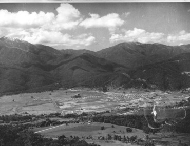
 Eltham District Historical Society Inc
Photograph - Digital Photograph, Alan King, Maroondah Aqueduct Siphon Bridge over the Plenty River, 26 January 2008
... Miners who built the tunnels camped just north of Churinga in Greensborough – then called Tunnel Hill Camp – and adjacent to the Evelyn Arms Hotel. ...Miners who built the tunnels camped just north of Churinga in Greensborough – then called Tunnel Hill Camp – and adjacent to the Evelyn Arms Hotel. ...Opened in 1891, the bridge formed part of the Maroondah Aqueduct carrying water from Watts River near Healesville to the reservoir at Preston where it joined Melbourne's metropolitan water system. Covered under Heritage Overlay, Nillumbik Planning Scheme. Published: Nillumbik Now and Then / Marguerite Marshall 2008; photographs Alan King with Marguerite Marshall.; p99 Built to supply thirsty Melbourne in the late 19th century, the siphon bridge spanning the Plenty River off Leischa Court, Greensborough, was part of an engineering masterpiece. Opened in 1891, the bridge formed part of the Maroondah Aqueduct carrying water from the Watts River near Healesville to the reservoir at Preston where it joined the metropolitan distribution system. A major link in Melbourne’s water supply, it also had a huge impact on communities, which mushroomed along its route. Named after the Aboriginal word for the area around the Maroondah Reservoir, the Maroondah Aqueduct was fully operational until the 1970s. Since the 1980s the land along parts of the aqueduct have been used for walking and bicycle riding, shaded in places by Monterey Pine trees planted to stabilise the surrounding ground. From 1857 the Yan Yean Reservoir supplied Melbourne’s water but the growing city needed additional catchments.1 In 1886 work began on a weir on the Watts River to enable the aqueduct to carry most of the river water 41 miles (66km) to Melbourne. The aqueduct, built by the Board of Works, is the oldest remaining aqueduct near Melbourne and was probably the first built with concrete.2 Although the aqueduct is now only used between the Maroondah and Sugarloaf Reservoirs, it can still be traced across the Shire. It extends from the Maroondah Reservoir through Christmas Hills, Kangaroo Ground, Research, Eltham, St Helena and then previously wound west through Greensborough to Reservoir.3 Built by horse and manpower the aqueduct gravity fed 25 million gallons (113.6ML) of water a day to Melbourne along a gradient of one foot to the mile. It included 25 miles (41km) of open concrete and brick channel, six miles (10km) of tunnels, and nine miles (15km) of 14 inverted siphons of riveted wrought-iron across creeks. Bricks for the aqueduct were made from clay found near the sites and remains of several kilns can still be found between Kangaroo Ground and Christmas Hills. Building the aqueduct transformed local communities. An abattoir was established at Christmas Hills. Grog shanties and labourers’ camps sprang up and local courts dealt with cases of ‘petty pilfering and boisterous behaviour’.4 The Kangaroo Ground school population jumped to 91, crammed into a room with one teacher. Miners who built the tunnels camped just north of Churinga in Greensborough – then called Tunnel Hill Camp – and adjacent to the Evelyn Arms Hotel. The miners’ high spirits were sometimes quenched in horse troughs or by a ‘welt under the ear and kick on the behind’ as the local constable calmed them down rather than lock them up.5 But the growing city of Melbourne needed more water, so the O’Shannassy catchment, east of Warburton, was added to the system in 1914. In 1920 work began on the present concrete Maroondah Dam one mile (1.6km) from the weir on the Watts River. The aqueduct capacity was thus doubled to 50 million gallons (227ML) a day.6 Intense land development threatened to pollute the open water supply, so channel sections were replaced with large pipes. In the late 1960s a large water main was built from the tunnel outlet at Research and extended through St Helena and Greensborough, so this section of the aqueduct was taken out of use. Long sections of the unused open channels in Greensborough and Bundoora were destroyed, but the old channel in Research and Eltham North remained largely intact. In the 1970s, the Sugarloaf Reservoir was constructed, inundating 445 hectares of land in Christmas Hills. Sugarloaf was officially opened in 1980 and serves as a water storage and treatment plant supplying Melbourne. In the early 1980s pipes replaced the section from Sugarloaf Reservoir to the tunnel entrance at Kangaroo Ground. The Research-Kangaroo Ground tunnel operates as part of the pipeline system.This collection of almost 130 photos about places and people within the Shire of Nillumbik, an urban and rural municipality in Melbourne's north, contributes to an understanding of the history of the Shire. Published in 2008 immediately prior to the Black Saturday bushfires of February 7, 2009, it documents sites that were impacted, and in some cases destroyed by the fires. It includes photographs taken especially for the publication, creating a unique time capsule representing the Shire in the early 21st century. It remains the most recent comprehenesive publication devoted to the Shire's history connecting local residents to the past. nillumbik now and then (marshall-king) collection, maroondah aqueduct, pipe bridge, siphon bridge -
 Kiewa Valley Historical Society
Photos: Kiewa Hydro Electric Scheme x 12
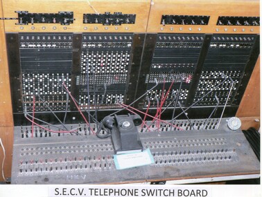
... Map of the Kiewa Hydro Scheme 9.Howman's Gap Camp 10.Tunnel Excavation Face 11. Mt Beauty Townhship 1948, looking north east 12. ...Map of the Kiewa Hydro Scheme 9.Howman's Gap Camp 10.Tunnel Excavation Face 11. Mt Beauty Townhship 1948, looking north east 12. ...K.H.E.S.Photos 4 coloured and 8 black and white with the Title printed below each one. 1. S.E.C.V. Telephone Switch Board (See also KVHS 0847) 2.West Kiewa Tunnel 3. Construction of Underground Power Station 4. Pretty Vally Camp 5.Outside Kiewa House, Bogong 6. S.E.C.V. Saucer (See also KVHS 0128) 7.Insulator Disk Struck by Lightning 8. S.E.C.V. Map of the Kiewa Hydro Scheme 9.Howman's Gap Camp 10.Tunnel Excavation Face 11. Mt Beauty Townhship 1948, looking north east 12. Mt Beauty Township - no labelkiewa hydro electric scheme photos -
 Kiewa Valley Historical Society
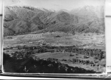
Photograph - Mt Beauty Camp, Estimated 1950-1951
... camp was enlarged in 1950 to the extent of providing accommodation for a total of 1,200. There are a number of dwellings on Simmonds Creek and the road to Falls Creek can clearly be seen. Snow capped Mt. Bogong is in the upper left of the photo with Mt. Beauty behind the township rising to Big Hill beyond that. Shows the newly constructed town of Mt. Beauty surrounded by farmland and before the regulating pondage was built to discharge water from the power stations via the West Kiewa tail race tunnel ...This photo is of the very newly constructed State Electricity Commission town of Mt. Beauty. The houses up to Nelse street were erected from 1946 onward and then the township was extended beyond Nelse Street in 1950 which places this photograph about 1950/51. There is no evidence of work being commenced on the regulating pondage but the tail race canal can be seen on the centre right of photo. The workmen's camp was enlarged in 1950 to the extent of providing accommodation for a total of 1,200. There are a number of dwellings on Simmonds Creek and the road to Falls Creek can clearly be seen. Snow capped Mt. Bogong is in the upper left of the photo with Mt. Beauty behind the township rising to Big Hill beyond that.Shows the newly constructed town of Mt. Beauty surrounded by farmland and before the regulating pondage was built to discharge water from the power stations via the West Kiewa tail race tunnel into the Kiewa River. Copy of black and white photograph of Mt Beauty CampWritten on the back in black ink - A Campenmt beauty camp, secv, construction town -
 Kiewa Valley Historical Society
Photographs – SECV – Clover Power Station
... Set of 22 black and white photographs taken by the official SECV photographer who gave each photo a number prefixed by K (for Kiewa) K60 -no date- A bridge and entrance to tunnel K519 -no date- Welding steel lining in the tunnel K531 –no date- Construction on the Kiewa Scheme (tunnel in background K821 – no date- Bogong Village, early days K928 -15 Oct 1942- Construction Clover Power Station K947 -26 Oct 1942- Construction Clover Power Station K948 -26 Oct 1942- Construction Clover Power Station K949- 26 Oct 1942- Clover Camp in background K950 -26 Oct 1942- Construction Clover Power Station K955 -27 Oct 1942- Constructing the bridge at Clover K1102 -7 April 1943- Inlet pipe to power station K1179 –no date- Clover Power Station K1187 – no date- Clover Power Station K1189 -24 June 1943- Part of the spiral casing 1199 -7 July 1943- Clover Power Station K1201 -7 July 1943- Clover Power Station K1231 -26 July 1943- Gantry crane for Clover Power Station K1308 -6 Sept 1943- Spiral casing K1334 -6 Oct 1943- Lake Guy. ...SECV; Kiewa Hydro Electric Scheme; official photographer; Junction Dam; Clover Power Station; Bogong; On the back- each photograph has a handwritten reference number starting with K and the date stamped or written (see above) Set of 22 black and white photographs taken by the official SECV photographer who gave each photo a number prefixed by K (for Kiewa) K60 -no date- A bridge and entrance to tunnel K519 -no date- Welding steel lining in the tunnel K531 –no date- Construction on the Kiewa Scheme (tunnel in background K821 – no date- Bogong Village, early days K928 -15 Oct 1942- Construction Clover Power Station K947 -26 Oct 1942- Construction Clover Power Station K948 -26 Oct 1942- Construction Clover Power Station K949- 26 Oct 1942- Clover Camp in background K950 -26 Oct 1942- Construction Clover Power Station K955 -27 Oct 1942- Constructing the bridge at Clover K1102 -7 April 1943- Inlet pipe to power station K1179 –no date- Clover Power Station K1187 – no date- Clover Power Station K1189 -24 June 1943- Part of the spiral casing 1199 -7 July 1943- Clover Power Station K1201 -7 July 1943- Clover Power Station K1231 -26 July 1943- Gantry crane for Clover Power Station K1308 -6 Sept 1943- Spiral casing K1334 -6 Oct 1943- Lake Guy. ...The Junction Dam and Clover Dam Power Station, stages of the Kiewa Hydro-Electric Scheme, were needed to meet the increased power demands of the wartime industry in Victoria. Clover added 26 megawatts to the grid. Junction Dam was completed and ready to hold water by September 1943, but was emptied in December 1943 and not filled again until May 1944. Construction of Clover Power Station commenced in July 1941 and both turbines were in service by May 1945.Clover Power Station and Junction Dam were part of the Kiewa Hydro Electric Scheme constructed by the State Electricity Commission of Victoria.Set of 22 black and white photographs taken by the official SECV photographer who gave each photo a number prefixed by K (for Kiewa) K60 -no date- A bridge and entrance to tunnel K519 -no date- Welding steel lining in the tunnel K531 –no date- Construction on the Kiewa Scheme (tunnel in background K821 – no date- Bogong Village, early days K928 -15 Oct 1942- Construction Clover Power Station K947 -26 Oct 1942- Construction Clover Power Station K948 -26 Oct 1942- Construction Clover Power Station K949- 26 Oct 1942- Clover Camp in background K950 -26 Oct 1942- Construction Clover Power Station K955 -27 Oct 1942- Constructing the bridge at Clover K1102 -7 April 1943- Inlet pipe to power station K1179 –no date- Clover Power Station K1187 – no date- Clover Power Station K1189 -24 June 1943- Part of the spiral casing 1199 -7 July 1943- Clover Power Station K1201 -7 July 1943- Clover Power Station K1231 -26 July 1943- Gantry crane for Clover Power Station K1308 -6 Sept 1943- Spiral casing K1334 -6 Oct 1943- Lake Guy. Bogong Village in background K1342 -29 Oct 1943- Power station under construction K1365 -19 Nov 1943- Power station under construction K1366 -19 Nov 1943- Gantry crane for Clover Power Station On the back- each photograph has a handwritten reference number starting with K and the date stamped or written (see above)secv; kiewa hydro electric scheme; official photographer; junction dam; clover power station; bogong; -
 Kiewa Valley Historical Society
Photograph - Folder of Photographs (KVHS 1150 A - F) – Photocopied set of black and white photographs from the display folder (pages 1 - 8) put together by KVHS to document life on the Kiewa Valley Hydro-electric Scheme
... Large A3 size spiral bound display folder containing 21 of 58 pages of photocopied black and white photographs of various aspects of the early days of the Kiewa Valley Hydro-electric scheme including equipment, various work sites and photographs of workers and their families. 1-Front page; 2-Security gate at Mt Beauty Camp; 3-Channel 1 on East Kiewa River; 4-Junction Dam – Diversion Tunnel Inlet; 5-Sawmill; 6- Homan’s Gap Sawmill; 7 Junction Dam: 8-Homan Dam Site-Diamond Drilling on River Buttress; 9- Homan Dam Site View Upstream 10-Homan Dam Investigation Camp ...camp and mess in background 3- STATE ELECTRICITY COMMISSION OF VICTORIA Date; 11.3.40 Time: 10.30am No K35 Kiewa Hydro Electric Works. Diverting East Kiewa River into Channel Page number 1 4-STATE ELECTRICITY COMMISSION OF VICTORIA Date: 5.4.40 Time: Noon No K58 Kiewa Hydro Electric Works. Junction Dam – Diversion Tunnel...camp and mess in background 3- STATE ELECTRICITY COMMISSION OF VICTORIA Date; 11.3.40 Time: 10.30am No K35 Kiewa Hydro Electric Works. Diverting East Kiewa River into Channel Page number 1 4-STATE ELECTRICITY COMMISSION OF VICTORIA Date: 5.4.40 Time: Noon No K58 Kiewa Hydro Electric Works. Junction Dam – Diversion Tunnel ...Although the Kiewa Hydro-Electric Scheme was first proposed in 1911, construction did not commence until 1938. As part of the push to cut electricity costs and diversify supply, the Victorian Government (circa 1930) initiated the conversion from primarily brown coal supply to hydro – electricity. Field investigations during the 1940’s resulted in a new proposal for a scheme that had more than double the capacity of the 1938 scheme. The Kiewa Hydroelectric Scheme became the largest scheme of its kind in the State Of Victoria and the second largest scheme in Australia. The number of personnel involved in the planning and construction of the scheme increased dramatically. During the late 1940’s, most activity centred around the construction of the West Kiewa Power Station, Rocky Valley Reservoir, McKay Creek Power Station and the Bogong Creek Aqueduct.A common thread across all the larger hydro scheme constructions was the need for workers, both qualified and unqualified who came from around the world seeking a new life for themselves and their families. New accommodation and facilities were required for the army of workers engaged in construction in often remote and wild areas. The SEC had a high demand for timber, and set up the first of a number of sawmills at Bogong Creek in 1939 and set up the first hardwood logging in the headwaters of the Kiewa River. These new ‘towns’ such as Mt Beauty and Bogong, survived, serving the needs of operational personnel and their families, and expanding with growth of new industries. Mount Beauty, and to a lesser extent Bogong, are among these places. Large A3 size spiral bound display folder containing 21 of 58 pages of photocopied black and white photographs of various aspects of the early days of the Kiewa Valley Hydro-electric scheme including equipment, various work sites and photographs of workers and their families. 1-Front page; 2-Security gate at Mt Beauty Camp; 3-Channel 1 on East Kiewa River; 4-Junction Dam – Diversion Tunnel Inlet; 5-Sawmill; 6- Homan’s Gap Sawmill; 7 Junction Dam: 8-Homan Dam Site-Diamond Drilling on River Buttress; 9- Homan Dam Site View Upstream 10-Homan Dam Investigation Camp 1-Windsor & Newton Visual Diary 60 sheet (120 pages) 11’ x 14’ 280 x 356mm 110 GSM Acid Free Drawing Paper 2-1940-Security Gate on Mt Beauty side of Kiewa River bridge. Part of old Mt Beauty camp and mess in background 3- STATE ELECTRICITY COMMISSION OF VICTORIA Date; 11.3.40 Time: 10.30am No K35 Kiewa Hydro Electric Works. Diverting East Kiewa River into Channel Page number 1 4-STATE ELECTRICITY COMMISSION OF VICTORIA Date: 5.4.40 Time: Noon No K58 Kiewa Hydro Electric Works. Junction Dam – Diversion Tunnel Inlet – Normal Flow Page number 2 5- STATE ELECTRICITY COMMISSION OF VICTORIA Date: 19.8.42 Time: 2.30pm No K883 Kiewa Hydro Electric Works. Sawmill – General View Page number 3 6- STATE ELECTRICITY COMMISSION OF VICTORIA Date: 12.1.42 Time: 2.00pm No K540 Kiewa Hydro Electric Works. Homan’s Gap Sawmill – General View Page number 4 7- STATE ELECTRICITY COMMISSION OF VICTORIA Date: 12.1.42 Time: 2.00pm No K540 Kiewa Hydro Electric Works. Junction Dam – General View looking upstream Page number 5 8- STATE ELECTRICITY COMMISSION OF VICTORIA Date: 16.11.45 Time: 10.32amm No K52153 Kiewa Hydro Electric Works Homan Dam Site – Diamond Drilling on River Buttress Page number 6 9-STATE ELECTRICITY COMMISSION OF VICTORIA Date: 15.1.45 Time: 4.10pm No K1781 Kiewa Hydro Electric Works Homan Dam Site – View Upstream Page number 7 10- STATE ELECTRICITY COMMISSION OF VICTORIA Date: 15.1.45 Time: 4.10pm No K1781 Kiewa Hydro Electric Works Homan Dam Investigation Camp 1944 – 1945 Page number 8 secv; kiewa hydro electric scheme; mt beauty; bogong; construction work; -
 Kiewa Valley Historical Society
Photograph - Folder of Photographs – Photocopied set of black and white photographs (pages 9 - 18) from the display folder put together by KVHS to document life on the Kiewa Valley Hydro-electric Scheme
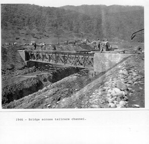
... PHYSICAL: Large A3 size spiral bound display folder containing 21 pages of photocopied black and white photographs of various aspects of the early days of the Kiewa Valley Hydro-electric scheme including equipment, various work sites and photographs of workers and their families. 1-Bridge across Tailrace Channel 1946 2-New Mess building, Mt Beauty 3-Homan’s Gap Saw Mill 4- Diamond Drilling Plant – Big Hill 5-Rocky Valley Camp-Mess Building 6-Parlimentary Party at Rocky Valley 7-No.4 Headrace Tunnel 8- Allis-Chalmers Tractor School 9- SECV Heavy Machinery lined up by road 10- No. 5 Raceline – Balasting Track with improvised truck ...1-1946 – Bridge across tailrace channel Page number 9 2-New mess building, Mt Beauty 6.4.46 Page number 10 3- STATE ELECTRICITY COMMISSION OF VICTORIA Date: 10.1.47 Time: 11.40am No K2271 Kiewa Hydro Electric Works Homan’s Gap Saw Mill – Rip Saw Page number 11 4- STATE ELECTRICITY COMMISSION OF VICTORIA Date: 5.10.47 Time: 11am No K4111 Kiewa Hydro Electric Works Diamond Drilling Plant – Big Hill Page number 12 5- STATE ELECTRICITY COMMISSION OF VICTORIA Date: 11.2.48 Time: 3pm No K4277 Kiewa Hydro Electric Works Rocky Valley Camp-Mess Building Page number 13 6- STATE ELECTRICITY COMMISSION OF VICTORIA Date: 15.4.48 Time: 4.30pm No K4397 Kiewa Hydro Electric Works Parlimentary Party at Rocky Valley Page number 14 7- STATE ELECTRICITY COMMISSION OF VICTORIA Date: 22.8.48 Time: 9am No K4668 Kiewa Hydro Electric Works General view of No.4 Headrace Tunnel Page number 15 8-STATE ELECTRICITY COMMISSION OF VICTORIA Date: 5.9.49 Time: 10am No K5180 Kiewa Hydro Electric Works Allis-Chalmers Tractor School – HD 19, Mr I Crossthwaite at Controls Page number 16 9- No markings Page number 17 10- STATE ELECTRICITY COMMISSION OF VICTORIA Date: 7,12.49 Time: 4pm No K5423 Kiewa Hydro Electric Works No. 5 Raceline – Balasting Track with improvised truck. ...Page number 18 PHYSICAL: Large A3 size spiral bound display folder containing 21 pages of photocopied black and white photographs of various aspects of the early days of the Kiewa Valley Hydro-electric scheme including equipment, various work sites and photographs of workers and their families. 1-Bridge across Tailrace Channel 1946 2-New Mess building, Mt Beauty 3-Homan’s Gap Saw Mill 4- Diamond Drilling Plant – Big Hill 5-Rocky Valley Camp-Mess Building 6-Parlimentary Party at Rocky Valley 7-No.4 Headrace Tunnel 8- Allis-Chalmers Tractor School 9- SECV Heavy Machinery lined up by road 10- No. 5 Raceline – Balasting Track with improvised truck Photograph Folder of Photographs – Photocopied set of black and white photographs (pages 9 - 18) from the display folder put together by KVHS to document life on the Kiewa Valley Hydro-electric Scheme ...Although the Kiewa Hydro-Electric Scheme was first proposed in 1911, construction did not commence until 1938. As part of the push to cut electricity costs and diversify supply, the Victorian Government (circa 1930) initiated the conversion from primarily brown coal supply to hydro – electricity. Field investigations during the 1940’s resulted in a new proposal for a scheme that had more than double the capacity of the 1938 scheme. The Kiewa Hydroelectric Scheme became the largest scheme of its kind in the State Of Victoria and the second largest scheme in Australia. The number of personnel involved in the planning and construction of the scheme increased dramatically. During the late 1940’s, most activity centred around the construction of the West Kiewa Power Station, Rocky Valley Reservoir, McKay Creek Power Station and the Bogong Creek Aqueduct.A common thread across all the larger hydro scheme constructions was the need for workers, both qualified and unqualified who came from around the world seeking a new life for themselves and their families. New accommodation and facilities were required for the army of workers engaged in construction in often remote and wild areas. The SEC had a high demand for timber, and set up the first of a number of sawmills at Bogong Creek in 1939 and set up the first hardwood logging in the headwaters of the Kiewa River. These new ‘towns’ such as Mt Beauty and Bogong, survived, serving the needs of operational personnel and their families, and expanding with growth of new industries. Mount Beauty, and to a lesser extent Bogong, are among these places. PHYSICAL: Large A3 size spiral bound display folder containing 21 pages of photocopied black and white photographs of various aspects of the early days of the Kiewa Valley Hydro-electric scheme including equipment, various work sites and photographs of workers and their families. 1-Bridge across Tailrace Channel 1946 2-New Mess building, Mt Beauty 3-Homan’s Gap Saw Mill 4- Diamond Drilling Plant – Big Hill 5-Rocky Valley Camp-Mess Building 6-Parlimentary Party at Rocky Valley 7-No.4 Headrace Tunnel 8- Allis-Chalmers Tractor School 9- SECV Heavy Machinery lined up by road 10- No. 5 Raceline – Balasting Track with improvised truck 1-1946 – Bridge across tailrace channel Page number 9 2-New mess building, Mt Beauty 6.4.46 Page number 10 3- STATE ELECTRICITY COMMISSION OF VICTORIA Date: 10.1.47 Time: 11.40am No K2271 Kiewa Hydro Electric Works Homan’s Gap Saw Mill – Rip Saw Page number 11 4- STATE ELECTRICITY COMMISSION OF VICTORIA Date: 5.10.47 Time: 11am No K4111 Kiewa Hydro Electric Works Diamond Drilling Plant – Big Hill Page number 12 5- STATE ELECTRICITY COMMISSION OF VICTORIA Date: 11.2.48 Time: 3pm No K4277 Kiewa Hydro Electric Works Rocky Valley Camp-Mess Building Page number 13 6- STATE ELECTRICITY COMMISSION OF VICTORIA Date: 15.4.48 Time: 4.30pm No K4397 Kiewa Hydro Electric Works Parlimentary Party at Rocky Valley Page number 14 7- STATE ELECTRICITY COMMISSION OF VICTORIA Date: 22.8.48 Time: 9am No K4668 Kiewa Hydro Electric Works General view of No.4 Headrace Tunnel Page number 15 8-STATE ELECTRICITY COMMISSION OF VICTORIA Date: 5.9.49 Time: 10am No K5180 Kiewa Hydro Electric Works Allis-Chalmers Tractor School – HD 19, Mr I Crossthwaite at Controls Page number 16 9- No markings Page number 17 10- STATE ELECTRICITY COMMISSION OF VICTORIA Date: 7,12.49 Time: 4pm No K5423 Kiewa Hydro Electric Works No. 5 Raceline – Balasting Track with improvised truck. Page number 18 secv; kiewa hydro electric scheme; mt beauty; bogong; construction area -
 Kiewa Valley Historical Society
Photograph - Folder of Photographs – Photocopied set of 10 black and white photographs (pages 29 - 38) from the display folder put together by KVHS to document life on the Kiewa Valley Hydro-electric Scheme
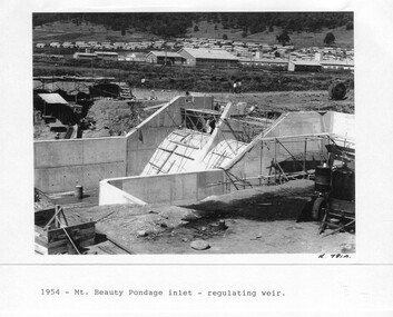
... Large A3 size spiral bound display folder containing 21 pages of photocopied black and white photographs of various aspects of the early days of the Kiewa Valley Hydro-electric scheme including equipment, various work sites and photographs of workers and their families. 1-Mt Beauty Pondage inlet-Regulating weir 2-Langfords Gap Basalt Hill-Tunnel in quarry face.3-Rocky Valley Camp-from Engineering Office 4-Basalt Hill tunnel portal 5-No 1 Pressure Shaft Works Bench 6-No 1 Power Station 7-Overturned haulage wagons on the side of an embankment 8- Group of workers dressed in wet weather gear inside a tunnel 9-Workmen and vehicle in tunnel 10-Howman’s Gap campsite at 4,150 feet ...1-1954 – Mt Beauty Pondage inlet – Regulating weir Page number 29 2-28/10/54 – Langfords Gap Basalt Hill – Tunnel in quarry face K7860 Page number 30 3-STATE ELECTRICITY COMMISSION OF VICTORIA Date: 17.8.55 Time: No K8132 Kiewa Hydro Electric Works ROCKY VALLEY CAMP – FROM ENGINEERING OFFICE Page number 31 4-28/10/54 – Basalt Hill tunnel portal K7859 Page number 32 5-No.1 Pressure Shaft Works Bench 5.7.56 Page number 33 6- No. 1 Power Station 26.4.59 Page number 34 7- No markings Page number 35 8-No markings (Wooden board on ground printed with - POLAR A.N.GELATINE DYNAMITE “75” DE 28.8.40) Page number 36 9-No markings Page number 37 10-Howman’s Gap campsite at 4,150 feet Page number 38 ...Mount Beauty, and to a lesser extent Bogong, are among these places. secv; kiewa hydro electric scheme; mt beauty; bogong; construction area 1-1954 – Mt Beauty Pondage inlet – Regulating weir Page number 29 2-28/10/54 – Langfords Gap Basalt Hill – Tunnel in quarry face K7860 Page number 30 3-STATE ELECTRICITY COMMISSION OF VICTORIA Date: 17.8.55 Time: No K8132 Kiewa Hydro Electric Works ROCKY VALLEY CAMP – FROM ENGINEERING OFFICE Page number 31 4-28/10/54 – Basalt Hill tunnel portal K7859 Page number 32 5-No.1 Pressure Shaft Works Bench 5.7.56 Page number 33 6- No. 1 Power Station 26.4.59 Page number 34 7- No markings Page number 35 8-No markings (Wooden board on ground printed with - POLAR A.N.GELATINE DYNAMITE “75” DE 28.8.40) Page number 36 9-No markings Page number 37 10-Howman’s Gap campsite at 4,150 feet Page number 38 Large A3 size spiral bound display folder containing 21 pages of photocopied black and white photographs of various aspects of the early days of the Kiewa Valley Hydro-electric scheme including equipment, various work sites and photographs of workers and their families. 1-Mt Beauty Pondage inlet-Regulating weir 2-Langfords Gap Basalt Hill-Tunnel in quarry face.3-Rocky Valley Camp-from Engineering Office 4-Basalt Hill tunnel portal 5-No 1 Pressure Shaft Works Bench 6-No 1 Power Station 7-Overturned haulage wagons on the side of an embankment 8- Group of workers dressed in wet weather gear inside a tunnel 9-Workmen and vehicle in tunnel 10-Howman’s Gap campsite at 4,150 feet Photograph Folder of Photographs – Photocopied set of 10 black and white photographs (pages 29 - 38) from the display folder put together by KVHS to document life on the Kiewa Valley Hydro-electric Scheme ...Although the Kiewa Hydro-Electric Scheme was first proposed in 1911, construction did not commence until 1938. As part of the push to cut electricity costs and diversify supply, the Victorian Government (circa 1930) initiated the conversion from primarily brown coal supply to hydro – electricity. Field investigations during the 1940’s resulted in a new proposal for a scheme that had more than double the capacity of the 1938 scheme. The Kiewa Hydroelectric Scheme became the largest scheme of its kind in the State Of Victoria and the second largest scheme in Australia. The number of personnel involved in the planning and construction of the scheme increased dramatically. During the late 1940’s, most activity centred around the construction of the West Kiewa Power Station, Rocky Valley Reservoir, McKay Creek Power Station and the Bogong Creek Aqueduct.A common thread across all the larger hydro scheme constructions was the need for workers, both qualified and unqualified who came from around the world seeking a new life for themselves and their families. New accommodation and facilities were required for the army of workers engaged in construction in often remote and wild areas. The SEC had a high demand for timber, and set up the first of a number of sawmills at Bogong Creek in 1939 and set up the first hardwood logging in the headwaters of the Kiewa River. These new ‘towns’ such as Mt Beauty and Bogong, survived, serving the needs of operational personnel and their families, and expanding with growth of new industries. Mount Beauty, and to a lesser extent Bogong, are among these places. Large A3 size spiral bound display folder containing 21 pages of photocopied black and white photographs of various aspects of the early days of the Kiewa Valley Hydro-electric scheme including equipment, various work sites and photographs of workers and their families. 1-Mt Beauty Pondage inlet-Regulating weir 2-Langfords Gap Basalt Hill-Tunnel in quarry face.3-Rocky Valley Camp-from Engineering Office 4-Basalt Hill tunnel portal 5-No 1 Pressure Shaft Works Bench 6-No 1 Power Station 7-Overturned haulage wagons on the side of an embankment 8- Group of workers dressed in wet weather gear inside a tunnel 9-Workmen and vehicle in tunnel 10-Howman’s Gap campsite at 4,150 feet 1-1954 – Mt Beauty Pondage inlet – Regulating weir Page number 29 2-28/10/54 – Langfords Gap Basalt Hill – Tunnel in quarry face K7860 Page number 30 3-STATE ELECTRICITY COMMISSION OF VICTORIA Date: 17.8.55 Time: No K8132 Kiewa Hydro Electric Works ROCKY VALLEY CAMP – FROM ENGINEERING OFFICE Page number 31 4-28/10/54 – Basalt Hill tunnel portal K7859 Page number 32 5-No.1 Pressure Shaft Works Bench 5.7.56 Page number 33 6- No. 1 Power Station 26.4.59 Page number 34 7- No markings Page number 35 8-No markings (Wooden board on ground printed with - POLAR A.N.GELATINE DYNAMITE “75” DE 28.8.40) Page number 36 9-No markings Page number 37 10-Howman’s Gap campsite at 4,150 feet Page number 38 secv; kiewa hydro electric scheme; mt beauty; bogong; construction area -
 Kiewa Valley Historical Society
Photograph - Folder of Photographs – Photocopied set of black and white photographs (pages 49 -58) from the display folder put together by KVHS to document life on the Kiewa Valley Hydro-electric Scheme
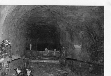
... Large A3 size spiral bound display folder containing photocopied black and white photographs of various aspects of the early days of the Kiewa Valley Hydro-electric scheme including equipment, various work sites and photographs of workers and their families. 1-Workmen working inside one of the tunnels. 2-Workman drilling in West Kiewa Tunnel 3-Junction Dam wall construction 4&5-2B&W photographs Kiewa House residents ready to go to a ball in Mt Beauty 6-Workmen warming up in front of a fire at No 1 bench 7-Workmen being hauled in at No 4 P.S Shaft 8-No 4 Power Station – Drilling 9-Workmen eating a hot meal in the tunnel. 10-2 photographs (a)Pretty Valley camp showing workman’s huts and construction materials & (b)Worker in Langford Gap Basalt Hill Tunnel face 11-Tunnel entrance (unlabelled) with rail tracks in foreground 12- Workmen drilling at No 1 Head race tunnel-Drilling face 13- No 1 Power Station 14-Workmen at the entrance to one of the SECV tunnels under construction ...Page number 51 13&14-No markings Page number 52 Large A3 size spiral bound display folder containing photocopied black and white photographs of various aspects of the early days of the Kiewa Valley Hydro-electric scheme including equipment, various work sites and photographs of workers and their families. 1-Workmen working inside one of the tunnels. 2-Workman drilling in West Kiewa Tunnel 3-Junction Dam wall construction 4&5-2B&W photographs Kiewa House residents ready to go to a ball in Mt Beauty 6-Workmen warming up in front of a fire at No 1 bench 7-Workmen being hauled in at No 4 P.S Shaft 8-No 4 Power Station – Drilling 9-Workmen eating a hot meal in the tunnel. 10-2 photographs (a)Pretty Valley camp showing workman’s huts and construction materials & (b)Worker in Langford Gap Basalt Hill Tunnel face 11-Tunnel entrance (unlabelled) with rail tracks in foreground 12- Workmen drilling at No 1 Head race tunnel-Drilling face 13- No 1 Power Station 14-Workmen at the entrance to one of the SECV tunnels under construction Photograph Folder of Photographs – Photocopied set of black and white photographs (pages 49 -58) from the display folder put together by KVHS to document life on the Kiewa Valley Hydro-electric Scheme ...Although the Kiewa Hydro-Electric Scheme was first proposed in 1911, construction did not commence until 1938. As part of the push to cut electricity costs and diversify supply, the Victorian Government (circa 1930) initiated the conversion from primarily brown coal supply to hydro – electricity. Field investigations during the 1940’s resulted in a new proposal for a scheme that had more than double the capacity of the 1938 scheme. The Kiewa Hydroelectric Scheme became the largest scheme of its kind in the State Of Victoria and the second largest scheme in Australia. The number of personnel involved in the planning and construction of the scheme increased dramatically. During the late 1940’s, most activity centred around the construction of the West Kiewa Power Station, Rocky Valley Reservoir, McKay Creek Power Station and the Bogong Creek Aqueduct.A common thread across all the larger hydro scheme constructions was the need for workers, both qualified and unqualified who came from around the world seeking a new life for themselves and their families. New accommodation and facilities were required for the army of workers engaged in construction in often remote and wild areas. The SEC had a high demand for timber, and set up the first of a number of sawmills at Bogong Creek in 1939 and set up the first hardwood logging in the headwaters of the Kiewa River. These new ‘towns’ such as Mt Beauty and Bogong, survived, serving the needs of operational personnel and their families, and expanding with growth of new industries. Mount Beauty, and to a lesser extent Bogong, are among these places. Large A3 size spiral bound display folder containing photocopied black and white photographs of various aspects of the early days of the Kiewa Valley Hydro-electric scheme including equipment, various work sites and photographs of workers and their families. 1-Workmen working inside one of the tunnels. 2-Workman drilling in West Kiewa Tunnel 3-Junction Dam wall construction 4&5-2B&W photographs Kiewa House residents ready to go to a ball in Mt Beauty 6-Workmen warming up in front of a fire at No 1 bench 7-Workmen being hauled in at No 4 P.S Shaft 8-No 4 Power Station – Drilling 9-Workmen eating a hot meal in the tunnel. 10-2 photographs (a)Pretty Valley camp showing workman’s huts and construction materials & (b)Worker in Langford Gap Basalt Hill Tunnel face 11-Tunnel entrance (unlabelled) with rail tracks in foreground 12- Workmen drilling at No 1 Head race tunnel-Drilling face 13- No 1 Power Station 14-Workmen at the entrance to one of the SECV tunnels under construction 1-SECV number at bottom of picture Half obscured possibly K8461 Page number 53 2-In West Kiewa Tunnel Page number 54 3- Construction of Junction Dam wall – approximately 1941 Page number 55 4&5- Residents of Kiewa House at Bogong ready to go to the ball at Mt Beauty-1946. Handwritten on a copy of the photo on opposite page Mrs Lorna Crosset filled out the names *Dad was Des Crossett – his daughter is Gael Petcopoulis Greta engaged to John broke it off. Charlie, Rosalind, Bill, Priscilla, Max Lawrence-Dad’s Boss, Mary & Max married, Mary, Kay, Gwen McPherson Mum’s boss, John McCluskey (c) At No. 5 Bench Page number 56 6- STATE ELECTRICITY COMMISSION OF VICTORIA Date: 27.2.51 Time:2.15pm No K6373 Kiewa Hydro Electric Works No. 4 P.S. Shaft – Haulage of men in buckets (b) As above Handwritten at top of photo Appendix 4 page number 57 7- STATE ELECTRICITY COMMISSION OF VICTORIA Date: 6.6.52 Time:… No K7122 Kiewa Hydro Electric Works No. 4 POWER STATION – DRILLING page number 58 8-No markings page number 59 9-(a)Handwritten under photograph Approx. 1948/49 (b) STATE ELECTRICITY COMMISSION OF VICTORIA Date: 28.10.54 Time:.. No K7860 Kiewa Hydro Electric Works LANGFORD GAP BASALT HILL TUNNEL FACE Page number 49 10-(a) No markings 11- STATE ELECTRICITY COMMISSION OF VICTORIA Date: 20.3.52 Time: No K6979 Kiewa Hydro Electric Works No. 1 HEAD RACE TUNNEL – DRILLING FACE (E.E.E. CONTRACT) ‘The Frenchies’ (E.E.E) as they were affectionately known Page number 50 12-31.5.56 No. 1 Power Station Aggregate Stock Piles. Page number 51 13&14-No markings Page number 52 secv; kiewa hydro electric scheme; bogong; mt beauty; construction area -
 Kiewa Valley Historical Society
Papers - Kiewa Hydro Electric Scheme, State Electricity Commission of Victoria / Kiewa Hydro Electric Project / Progress of the Undertaking, November 1953
... It included work on Power Stations, Dams, Tunnels, Race-lines and transmission lines as well as camps, towns, roads, telecommunications and infra structure. ...It included work on Power Stations, Dams, Tunnels, Race-lines and transmission lines as well as camps, towns, roads, telecommunications and infra structure. ...The SECV constructed the KHES from 1939 to 1961 on the Bogong High Plains. It included work on Power Stations, Dams, Tunnels, Race-lines and transmission lines as well as camps, towns, roads, telecommunications and infra structure. These papers give an understanding of where the project was up to in late 1953. These papers give information on the KHES on the aspects of work, its progress and technical detail.3 foolscap pages, stapled in the top left hand corner. Each page has sub headings re the progress of the works being undertaken on the Kiewa Hydro Electric Scheme.state electricity commission of victoria; kiewa hydro electric scheme; power stations; dams; tunnels; bogong high plains -
 Kiewa Valley Historical Society
Photograph of Mt. Beauty, Mt. Beauty from transmission line, Approx 1950/51
... camp was enlarged in 1950 to the extent of providing accommodation for a total of 1,200. There are a number of dwellings on Simmonds Creek and the road to Falls Creek can clearly be seen. Snow capped Mt. Bogong is in the upper left of the photo with Mt. Beauty behind the township rising to Big Hill beyond that. Shows the newly constructed town of Mt. Beauty surrounded by farmland and before the regulating pondage was built to discharge water from the power stations via the West Kiewa tail race tunnel ...This photo is of the very newly constructed State Electricity Commission town of Mt. Beauty. The houses up to Nelse street were erected from 1946 onward and then the township was extended beyond Nelse Street in 1950 which places this photograph about 1950/51. There is no evidence of work being commenced on the regulating pondage but the tail race canal can be seen on the centre right of photo. The workmen's camp was enlarged in 1950 to the extent of providing accommodation for a total of 1,200. There are a number of dwellings on Simmonds Creek and the road to Falls Creek can clearly be seen. Snow capped Mt. Bogong is in the upper left of the photo with Mt. Beauty behind the township rising to Big Hill beyond that.Shows the newly constructed town of Mt. Beauty surrounded by farmland and before the regulating pondage was built to discharge water from the power stations via the West Kiewa tail race tunnel into the Kiewa River. Black and white photographHand written on back of photograph "Mt. Beauty from Transmission Line"mt. beauty, construction, pondage, state electricity commission -
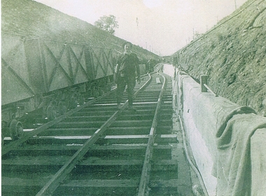 Kiewa Valley Historical Society
Photograph KHS Rail, Kiewa Hydroelectric Scheme Railway, Circa1940s
... Kiewa Valley Historical Society Mount Beauty Information Centre 31 Bogong High Plains Rd Mt Beauty high-country This photograph shows part of the railway constructed and used for the removal of soil and rocks from the tunnels bored out of the mountains for the pipeline servicing the Hydro Electricity power stations in the Kiewa Hydroelectric Scheme. This photo details an era when there were 4,000 construction workers located in two main accommodation camps, Mount Beauty (the larger one) and Bogong village. ...This photograph shows part of the railway constructed and used for the removal of soil and rocks from the tunnels bored out of the mountains for the pipeline servicing the Hydro Electricity power stations in the Kiewa Hydroelectric Scheme. This photo details an era when there were 4,000 construction workers located in two main accommodation camps, Mount Beauty (the larger one) and Bogong village. These accommodation sites were constructed and maintained as a secured or gated residential area with access only available by a special pass authorised by the Kiewa Hydroelectric Scheme. All the power used by the rail system was from electric motors connected to batteries. Overhead power poles seen on either side of the embankment details that electricity from the Scheme was in use. This use was cleaner and more environmentally friendly than the coal still used by large locomotives from city to country railways. The worker shown is not however wearing protective head and hand coverings. This is also an era where there was a lack of health and safety legislation covering workers in dangerous working conditions.Scanned photo of original black and white photo on Kodak XtraLife II paper. Picture is of a section of railway track servicing the tunnels of the Hydroelectric scheme during the 1940s - 1950sOn back of photo "Kodak XtraLife II paper"railway in kiewa electric scheme, tunneling -
Federation University Historical Collection
Book, Jacobs Lewis Vines Architects and Conservation Planners, Historic Sites Survey: Ballarat Study Area, 1980, 1980
... Barker Library (top floor) Mount Helen goldfields This survey was commissioned by the Land Conservation Council, Australian Heritage Commission and the Ministry for Conservation historic sites ballarat Wendy jacobs miles lewis gary vines berringa buninyong creswick dunnstown fiery creek lal lal langi logan cathcart mount cole Mount Egerton nerrina gong gong wombat state forest railways explorers routes early roads land conservation council ausralian hertiage commission department of planning ICOMOS (Burra) Charter nigel lewis richard aitken freehold land public land langi ghiran New jubille mine birthday tunnel mine pitfield plains smythesdale buninyong company Mount Clear mt clear canadian gully Warrenheip Distillery thomas mitchell waterloo trawalla beaufort raglan internment camps forestry mining mining mt egerton Mary Hollick Collection Jubilee Mine Burra Charter Historica areas data form explorers Egerton Company Black Horse mine Mt Egerton Government Battery kaolin Mines Anderson Brothers Barkstead Anderson's Tramway Clarkesdale Berry Leads Birthday Tunnel Mine Berringa Warrenheip Australasian Company Mount Mercer Lanvi-Kal-Kal water race 114 page report on historic sites in the Ballarat region. ...This survey was commissioned by the Land Conservation Council, Australian Heritage Commission and the Ministry for Conservation 114 page report on historic sites in the Ballarat region. It includes information on sites, a schexdule of sites, silte selection and designated areas (ie around towns)historic sites, ballarat, wendy jacobs, miles lewis, gary vines, berringa, buninyong, creswick, dunnstown, fiery creek, lal lal, langi logan, cathcart, mount cole, mount egerton, nerrina, gong gong, wombat state forest, railways, explorers routes, early roads, land conservation council, ausralian hertiage commission, department of planning, icomos (burra) charter, nigel lewis, richard aitken, freehold land, public land, langi ghiran, new jubille mine, birthday tunnel mine, pitfield plains, smythesdale, buninyong company, mount clear, mt clear, canadian gully, warrenheip distillery, thomas mitchell, waterloo, trawalla, beaufort, raglan, internment camps, forestry, mining, mining, mt egerton, mary hollick collection, jubilee mine, burra charter, historica areas data form, explorers, egerton company, black horse mine, mt egerton government battery, kaolin mines, anderson brothers, barkstead, anderson's tramway, clarkesdale, berry leads, birthday tunnel mine berringa, warrenheip, australasian company, mount mercer, lanvi-kal-kal, water race -
 Eltham District Historical Society Inc
Photograph - Digital Photograph, Alan King, Golden King Mine poppet-head, Yarrambat Primary School, 1 February 2008
... Tunnel Hill Hotel, on the Greensborough–Diamond Creek Road. An annual agricultural show in Diamond Creek paraded through the town, and New Year’s Day picnics at the Yan Yean Reservoir included highland dancing and competitions. Also popular were the Indian hawkers who visited every three months, selling trinkets, clothing and other items. One called Jimmy ‘Allem dem Bedi’, gave presents and told stories, played draughts and sold delicious curries he cooked over his camp...Tunnel Hill Hotel, on the Greensborough–Diamond Creek Road. An annual agricultural show in Diamond Creek paraded through the town, and New Year’s Day picnics at the Yan Yean Reservoir included highland dancing and competitions. Also popular were the Indian hawkers who visited every three months, selling trinkets, clothing and other items. One called Jimmy ‘Allem dem Bedi’, gave presents and told stories, played draughts and sold delicious curries he cooked over his camp ...The Golden King Mine poppet-head stands at the school’s Yan Yean Road exit gate. Published: Nillumbik Now and Then / Marguerite Marshall 2008; photographs Alan King with Marguerite Marshall.; p23 Early Yarambat - Tanck's Corner Its early settlers, who in the 1840s were amongst the first non-Aboriginal people in the area, found life tough as they grazed their sheep and cattle. Yarrambat was then known as Tanck’s Corner or Reynolds Corner, after wood carter, Frederick Tanck, who owned land north of Ironbark Road, at the corner of Yan Yean Road, and Thomas Reynolds, owner of the opposite property. After Reynolds sold his land, the corner became known as Tanck’s Corner. In 1929 the district’s name was changed to Yarrambat, believed to mean ‘high hill’ in the Wurundjeri language. Tanck’s Corner was in the centre of gold-bearing country and the district is honeycombed with old tunnels and shafts. However although gold played a dominant role for decades, there was insufficient to develop a substantial township. Meat and agricultural produce made a greater impact. Until the mid-20th century the only substantial building was the primary school. The first gold rush occurred around 1860, the second after 1900; then during the Depression, the Government paid men to pan for gold. The first rush attracted hundreds of Chinese people to Smugglers Gully, who constructed round diggings to keep away spirits. Alluvial miners lived along the Plenty River in tents or humpies - some fenced with gardens - and some miners distilled their own ‘plonk’. It was a wild time and bushrangers - and later gangster Squizzy Taylor - were said to hide4 in the old Pioneer Tunnel in Dunne’s Gully between Heard Avenue and Pioneer Road. Mines opposite Tanck’s Corner included Beer’s Line, Golden Crown and Golden Stairs. Some of the big mines had batteries and stampers to process quartz. At first there was plenty of alluvial gold, as much as two ounces to the ton. At times gold was exposed after heavy rains so fossickers panned for gold around orchard irrigation trenches. Gold was mined until 1984 when Yarrambat’s last operating goldmine, the Golden King Mine, in North Oatlands Road, closed. The Clayton family operated it full-time, making a comfortable living and in the 1960s it was the only private family gold mine in Victoria.5 Gold was such an important part of Yarrambat’s history that a gold poppet-head is the Yarrambat Primary School’s logo. The Golden King Mine poppet-head stands at the school’s Yan Yean Road exit gate. However this school was built in 1988. The original school No 2054, at the corner of Ironbark and Yan Yean Roads, was opened in 1878 and modified to its present form in the 1920s. In 2000 it was relocated to the Heritage Museum at Yarrambat Park.7 The school, whose first head teacher was Charles Planner, consisted of one room with a three-roomed residence. The school was also the community centre. On Saturday nights it was crammed for dances or euchre parties, community singing or other social events. On Sundays, services for different denominations took turns each week. However the school had its teething problems. Parents accused Charles Planner of neglecting his duties and the school closed several times. When it closed in 1892, only church services continued. Social activities moved elsewhere, such as the tennis club to the Stuchbery tennis court opposite. A sports day and woodchop on Boxing Day around 1900 was held at the Evelyn Hill Hotel, also called Evelyn Arms and Tunnel Hill Hotel, on the Greensborough–Diamond Creek Road. An annual agricultural show in Diamond Creek paraded through the town, and New Year’s Day picnics at the Yan Yean Reservoir included highland dancing and competitions. Also popular were the Indian hawkers who visited every three months, selling trinkets, clothing and other items. One called Jimmy ‘Allem dem Bedi’, gave presents and told stories, played draughts and sold delicious curries he cooked over his camp fire at night.This collection of almost 130 photos about places and people within the Shire of Nillumbik, an urban and rural municipality in Melbourne's north, contributes to an understanding of the history of the Shire. Published in 2008 immediately prior to the Black Saturday bushfires of February 7, 2009, it documents sites that were impacted, and in some cases destroyed by the fires. It includes photographs taken especially for the publication, creating a unique time capsule representing the Shire in the early 21st century. It remains the most recent comprehenesive publication devoted to the Shire's history connecting local residents to the past. nillumbik now and then (marshall-king) collection, golden king mine, tanck's corner, yarrambat primary school -
 The Beechworth Burke Museum
Photograph, est. 1860-1875
... Camp”, shown partly in the foreground, we see the central plant of the famous Rocky Mountain Mining Company. This extensive complex, of which nothing remains, was situated between Silver Creek and the present Lake Sambell area. The company was responsible for a tunnel...tunnel built in 1880 by the company, which was considered one of the greatest engineering feats of the time. The image also provides a first-hand look into the social and cultural networks at play during the 19th century with racial segregation of the Chinese at the 'Chinese Camp', as well as an insight into Beechworth's origins during the Gold Rush. beechworth rocky mountain mine sluicing gold rush mining gold Reverse: Historic Beechworth / 7792.1 / ROCKY MOUNTAIN MINE / Viewed from the “Chinese Camp”, shown partly in the foreground, we see the central plant of the famous Rocky Mountain Mining Company. ...In 1875, the Rocky Mountain Extended Gold Sluicing Company Ltd was created, utilising the previous Rocky Mountain claim for the area near Lake Sambell. The company employed A.L Martin to survey an area for a tunnel underneath Beechworth and Johnson Stephens to dig it. The tunnel was built at a rate of 40 feet a month and eventually measured 800 metres. The tunnel was a true accomplishment both in the present and during the 19th century. It was considered to be a marvelous engineering feat. Beechworth is renowned for its hydraulic sluice method of mining. This involved soil being exposed to torrents of water from high-pressure hoses. From 1876 until its closure in 1921, the mine produced an astounding 47,926 ozs of gold. Companies like this were the source of income for many Chinese gold-diggers who sought to make their fortune on the goldfields of Beechworth. During the height of the rush, the town had around 7,000 Chinese inhabitants living on the outskirts of town as they were not permitted to live within Beechworth itself.The search for gold is ingrained into the history of Victoria and therefore, images like this one which portrays an open-cut sluicing site can reveal important information for society and technology for the date when the photograph was taken. This image is of important historical significance for its ability to convey information about sluicing and the methods used to find gold in 1910. It also shows a location where sluicing was undertaken which provides insight into the impact of sluicing on the environment at a time when it was done. This image of the Rocky Mountain mine is historically significant as the mining complex is now non-existent, with the only remains being the tunnel built in 1880 by the company, which was considered one of the greatest engineering feats of the time. The image also provides a first-hand look into the social and cultural networks at play during the 19th century with racial segregation of the Chinese at the 'Chinese Camp', as well as an insight into Beechworth's origins during the Gold Rush.A sepia rectangular photograph printed on matte photographic paper as a postcardReverse: Historic Beechworth / 7792.1 / ROCKY MOUNTAIN MINE / Viewed from the “Chinese Camp”, shown partly in the foreground, we see the central plant of the famous Rocky Mountain Mining Company. This extensive complex, of which nothing remains, was situated between Silver Creek and the present Lake Sambell area. The company was responsible for a tunnel cut through solid bedrock underneath the town of Beechworth and surfacing near the keystone bridge on the Wangaratta side. Completed in 1880 it was declared to be one of the greatest engineering feats in Australia. The tunnel is still basically intact today. / Series by Wooragee Graphics: Historic Beechworth. / COPYRIGHT BURKE MUSEUM / No.72 beechworth, rocky mountain mine, sluicing, gold rush, mining, gold -
 The Beechworth Burke Museum
Photograph - Photograph - Reproduction
... tunnel built in 1880 by the company, which was considered one of the greatest engineering feats of the time. The image also provides a first-hand look into the social and cultural networks at play during the 19th century with racial segregation of the Chinese at the 'Chinese Camp', as well as an insight into Beechworth's origins during the Gold Rush. beechworth rocky mountain mine sluicing gold rush mining gold Black and white rectangular reproduced photograph printed on paper Photograph Photograph - Reproduction ...The photograph is a reproduction of a postcard from the Rocky Mountain Mining Company. In 1875, the Rocky Mountain Extended Gold Sluicing Company Ltd was created, utilising the previous Rocky Mountain claim for the area near Lake Sambell. The company employed A.L Martin to survey an area for a tunnel underneath Beechworth and Johnson Stephens to dig it. The tunnel was built at a rate of 40 feet a month and eventually measured 800 metres. The tunnel was a true accomplishment both in the present and during the 19th century. It was considered to be a marvelous engineering feat. Beechworth is renowned for its hydraulic sluice method of mining. This involved soil being exposed to torrents of water from high-pressure hoses. From 1876 until its closure in 1921, the mine produced an astounding 47,926 ozs of gold. Companies like this were the source of income for many Chinese gold-diggers who sought to make their fortune on the goldfields of Beechworth. During the height of the rush, the town had around 7,000 Chinese inhabitants living on the outskirts of town as they were not permitted to live within Beechworth itself.This image of the Rocky Mountain mine is historically significant as the mining complex is now non-existent, with the only remains being the tunnel built in 1880 by the company, which was considered one of the greatest engineering feats of the time. The image also provides a first-hand look into the social and cultural networks at play during the 19th century with racial segregation of the Chinese at the 'Chinese Camp', as well as an insight into Beechworth's origins during the Gold Rush.Black and white rectangular reproduced photograph printed on paperbeechworth, rocky mountain mine, sluicing, gold rush, mining, gold -
 Monbulk RSL Sub Branch
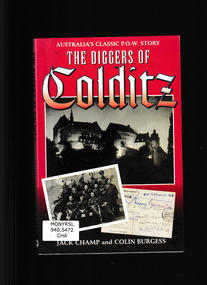
Book, Kangaroo Press, Diggers at Colditz, 1997
... He was, however, a reluctant prisoner and took part in two escapes from different POW camps, one of which was a mass break-out of sixty officers through a tunnel that had taken weeks to make. ...On June 23 1943 Lieutenant Jack Champ of the 2nd/6th Australian Infantry Battalion was marched into one of the most famous prisoner-of-war camps in Germany. Known then as Oflag IVC, it is now better know as Colditz. By the end of the war there were nineteen Australians in Colditz, and this is the first book to look at life there specifically from their point of view. It was a very special camp. It was designed to retain under escape-proof conditions, a select group of Allied prisoners who had already escaped from other camps and who had been recaptured whilst still in occupied territory. Having seen action in the Western Desert and in Greece, Jack Champ had been captured by the Germans in 1941. He was, however, a reluctant prisoner and took part in two escapes from different POW camps, one of which was a mass break-out of sixty officers through a tunnel that had taken weeks to make. Although the guards frequently outnumbered prisoners, there were more escapes from Colditz than from any other prison of comparable size during both World Wars. In this vivid book Jack Champ and Colin Burgess explain what it was like to be a prisoner in Nazi Germany. It is a curious blend of brutality and humanity, of routines and dreams, and occasional and dramatic excitement as men tried to turn those dreams into the reality of freedom.Index, ill, maps, p.224.non-fictionOn June 23 1943 Lieutenant Jack Champ of the 2nd/6th Australian Infantry Battalion was marched into one of the most famous prisoner-of-war camps in Germany. Known then as Oflag IVC, it is now better know as Colditz. By the end of the war there were nineteen Australians in Colditz, and this is the first book to look at life there specifically from their point of view. It was a very special camp. It was designed to retain under escape-proof conditions, a select group of Allied prisoners who had already escaped from other camps and who had been recaptured whilst still in occupied territory. Having seen action in the Western Desert and in Greece, Jack Champ had been captured by the Germans in 1941. He was, however, a reluctant prisoner and took part in two escapes from different POW camps, one of which was a mass break-out of sixty officers through a tunnel that had taken weeks to make. Although the guards frequently outnumbered prisoners, there were more escapes from Colditz than from any other prison of comparable size during both World Wars. In this vivid book Jack Champ and Colin Burgess explain what it was like to be a prisoner in Nazi Germany. It is a curious blend of brutality and humanity, of routines and dreams, and occasional and dramatic excitement as men tried to turn those dreams into the reality of freedom.world war 1939 – 1945 - prisons and prisoners – germany, world war 1939-1945 - personal narratives - australia -
 Bendigo Historical Society Inc.
Document - ''THE CHINESE ON THE BENDIGO GOLDFIELD'': PAPER BY ''JOCH'' ( J. O. O'HATTAM)
... Mention of - two distinct 'groups' of Chinese (Canton & via California) with their stated differences in appearance and type of working; differences between European and Chinese mines (shafts as well as drives i.e. circular as against rectangular; 'smoking' of the shafts and tunnels by the Chinese; space in Chinese camps i.e. crowding; condition of Chinese camps; fire at Emu Creek camp of 1887; names of camps - Golden Square, Jackass Flat, Myers Flat, Kangaroo Flat, White Hills, Kennington, East Bendigo (Grassy Flat) and ''as far out as Diamond Hill''; Constable Ryan disappearance....Mention of - two distinct 'groups' of Chinese (Canton & via California) with their stated differences in appearance and type of working; differences between European and Chinese mines (shafts as well as drives i.e. circular as against rectangular; 'smoking' of the shafts and tunnels by the Chinese; space in Chinese camps i.e. crowding; condition of Chinese camps; fire at Emu Creek camp of 1887; names of camps - Golden Square, Jackass Flat, Myers Flat, Kangaroo Flat, White Hills, Kennington, East Bendigo (Grassy Flat) and ''as far out as Diamond Hill''; Constable Ryan disappearance. ...''The Chinese on the Bendigo Goldfield'' - draft paper with pencilled and typed annotations by ''Joch'' (J O O'Hattam) - undated. ; last page states ''Extracts from letters in the O'Breen family, and personal research; These letters were written between 1856 and 1899 by Shane O'Breen''. Mention of - two distinct 'groups' of Chinese (Canton & via California) with their stated differences in appearance and type of working; differences between European and Chinese mines (shafts as well as drives i.e. circular as against rectangular; 'smoking' of the shafts and tunnels by the Chinese; space in Chinese camps i.e. crowding; condition of Chinese camps; fire at Emu Creek camp of 1887; names of camps - Golden Square, Jackass Flat, Myers Flat, Kangaroo Flat, White Hills, Kennington, East Bendigo (Grassy Flat) and ''as far out as Diamond Hill''; Constable Ryan disappearance.Shane O'Breenbendigo, chinese, history, goldfields, chinese. o'breen family, shane o'breen, constable ryan. pigtail. cantonese. chinese smoked shafts and tunnels. emu point. opium smoking shop. joss house. golden square. jackass flat, myers flat, kangaroo flat. white hills, kennington. west bendigo (grassy flat). diamond hill. -
 Federation University Historical Collection
Correspondence, Letter from Lance Matthews concerning the Snowy Mountains Scheme, 1958, 25/11/1958
... camp. Matthew was working for contractors, Kaiser Walsh, at the Base Plant Pool at Polo Flat about 2 miles out of Cooma. He was involved in a two week tour (inventory) of the Snowy River Scheme and saw most part of the project including Adaminaby Dam, Tunnel Pond, T1 power station and the sites and initial stages of Tooma Reservoir, Lobs Hole Reservoir, Jindabyne Reservoir and several access tunnels.....camp. Matthew was working for contractors, Kaiser Walsh, at the Base Plant Pool at Polo Flat about 2 miles out of Cooma. He was involved in a two week tour (inventory) of the Snowy River Scheme and saw most part of the project including Adaminaby Dam, Tunnel Pond, T1 power station and the sites and initial stages of Tooma Reservoir, Lobs Hole Reservoir, Jindabyne Reservoir and several access tunnels.. ...Lance Matthews was a former student of the Ballarat School of Mines. Dick Richards was the Principal Construction of the Snowy Scheme was managed by the Snowy Mountains Hydroelectric Authority, it officially began on 17 October 1949 and took 25 years, officially completed on 21 October 1972.A letter comprising of three handwritten pages discussing experiences of work with the Snowy River Authority by Lance Mattews. The letter was written to Richard W. Richards, Principal of the Ballarat School of Mines. A forth page is a response to the letter by Dick Richards. In the letter Matthew relates that he is living at Cooma in the East Camp, and compares the living condition to an army camp. Matthew was working for contractors, Kaiser Walsh, at the Base Plant Pool at Polo Flat about 2 miles out of Cooma. He was involved in a two week tour (inventory) of the Snowy River Scheme and saw most part of the project including Adaminaby Dam, Tunnel Pond, T1 power station and the sites and initial stages of Tooma Reservoir, Lobs Hole Reservoir, Jindabyne Reservoir and several access tunnels..dick richards, lance matthews -
Tatura Irrigation & Wartime Camps Museum
Photograph, 24/3/1917
... Tatura Irrigation & Wartime Camps Museum 49 Hogan Street Tatura the-murray Taken by photographer for State Rivers and Water Supply Commission. victorian state rivers and supply commission sugarloaf reservoir Medium sized black and white photograph. Sugarloaf Reservoir upper core wall, tower, tunnel ...Taken by photographer for State Rivers and Water Supply Commission.Medium sized black and white photograph. Sugarloaf Reservoir upper core wall, tower, tunnel, and lower dam under construction / Group of men left corner / Rocks in river bed foreground / Horse and cart off-centre left / Horse, cart, and men far right of centre / Words "Diversion Core Wall Tunnel and Riverbed" printed.victorian state rivers and supply commission, sugarloaf reservoir -
 Tatura Irrigation & Wartime Camps Museum
Ashtray, 1940 - 1946
... camp presbyterian church orphans orphanage Miniature bath shaped metal ash tray. On one side there is a rest for a cigarette. The bath shape rests on 3 ball shaped legs. Has been painted blue by the donor. Originally metal unpainted. The head end is higher - sloping down to the foot end. Presumably made by POW's during WW2. Found in 1956 in a tunnel ...Miniature bath shaped metal ash tray. On one side there is a rest for a cigarette. The bath shape rests on 3 ball shaped legs. Has been painted blue by the donor. Originally metal unpainted. The head end is higher - sloping down to the foot end. Presumably made by POW's during WW2. Found in 1956 in a tunnel by a Dhurringile boy.ash tray, metal work, dhurringile pow camp, presbyterian church, orphans, orphanage -
Tatura Irrigation & Wartime Camps Museum
Document, Account of shooting POW at Murchison, 1991 photocopied
... Tatura Irrigation & Wartime Camps Museum 49 Hogan Street Tatura the-murray Account of shooting POW at Murchison 21 September 1942. Added details of casualties, colonial inquiries, tunneling. pow murchison victoria pow shooting internment camps Folder with clear plastic front and red back. ...Account of shooting POW at Murchison 21 September 1942. Added details of casualties, colonial inquiries, tunneling.Folder with clear plastic front and red back.pow, murchison victoria, pow shooting, internment camps -
Tatura Irrigation & Wartime Camps Museum
Folder, Camp 13 Murchison. Archival material, 1991
... Camp 13. Documents include the names of 983 German POW's in Murchison August 1941 - January 1947. An interesting collection confiscated intelligence report. No 94 included 26 gall of wine, 9 drums of fruit in an advances state of fermentation, flex copper wire, clothing, petrol motor and miscellaneous cameras and wireless parts. A letter by the German Naval Commander to all families of the Kormoran crew. History of German POW's in WW2 by H. Wolf. Both in German. Map 13 B. the 21 September 1942 disturbance in D compound; report in German Sydney-Kormoran; weekly rations; dimensions of a tunnel...Drawings by Heinz Dohmen - Arandora Star; royal Oak both sunk by u boat ace Gunther Prien, Collins gunner Kloppe; Kormoran at the memorial service for HMAS Sydney; Red Cross reports in German as are letters; Rudi Pruckners escape; the general conditions and the recently found tunnel. gustav pohlig camp 13 murchison victoria hmas sydney hsk kormoran heinze dohman rudi pruckner Camp 13 Murchison. ...A large collection of events in regard to Camp 13. Documents include the names of 983 German POW's in Murchison August 1941 - January 1947. An interesting collection confiscated intelligence report. No 94 included 26 gall of wine, 9 drums of fruit in an advances state of fermentation, flex copper wire, clothing, petrol motor and miscellaneous cameras and wireless parts. A letter by the German Naval Commander to all families of the Kormoran crew. History of German POW's in WW2 by H. Wolf. Both in German. Map 13 B. the 21 September 1942 disturbance in D compound; report in German Sydney-Kormoran; weekly rations; dimensions of a tunnel 15 June 1942. Drawings by Heinz Dohmen - Arandora Star; royal Oak both sunk by u boat ace Gunther Prien, Collins gunner Kloppe; Kormoran at the memorial service for HMAS Sydney; Red Cross reports in German as are letters; Rudi Pruckners escape; the general conditions and the recently found tunnel.Foolscap size folder with pillar box red 3 cm wide flap which extends to the back. On the front red flap is the inscription below. Prominent centre left is Australia with gum trees and sentry box and anti clockwise POW 1941-194. A kangaroo and emu on the top right hand corner. Prison of war and beneath Murchison - Australian.Camp 13 Murchison. Archival material.gustav pohlig, camp 13, murchison victoria, hmas sydney, hsk kormoran, heinze dohman, rudi pruckner -
Tatura Irrigation & Wartime Camps Museum
Document, Probably early 1940's
... Tatura Irrigation & Wartime Camps Museum 49 Hogan Street Tatura the-murray Detailing some of the ingenious methods of escape and the camouflaging of tunnelling. ...Detailing some of the ingenious methods of escape and the camouflaging of tunnelling. In January 1945, 20 officers escaped from Dhurringile and Lt Edgardo Simone , the Italian P.O,W was the outstanding escapee in Australia. Others are noted in Barbara Winter's book "Stalag Australia"Clear plastic folder, red margin on which is a white strip of paper. A red back cover. On the top right hand corner on the front clear plastic is a white self adhesive label on which is printed " Security of Prisoners of war and Internees - and escapes - Australian War Museum Archives - Canberra.As noted aboveaustralian war museum archives -
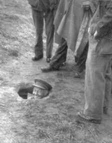 Tatura Irrigation & Wartime Camps Museum
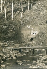
Photograph, Escape tunnel
... Camp Commanding Officer...Major William Ruthven...Dhurringile...escape tunnel...Tatura Irrigation & Wartime Camps Museum 49 Hogan Street Tatura the-murray Escape tunnel at Dhurringile. ...Escape tunnel at Dhurringile. The C.O. Major William Ruthven V.C. with head protruding.Sepia photograph of four men, legs only can be seen, standing next to a hole in the ground with Captain Ruthven's head and hat showingcamp commanding officer, major william ruthven, dhurringile, escape tunnel -
Tatura Irrigation & Wartime Camps Museum
Photograph, Dhurringile Escape
... Copy of map made in Dhurringile POW Camp and carried by Captain Detmers during the tunnel escape by twenty German Officers and men. ...Tatura Irrigation & Wartime Camps Museum 49 Hogan Street Tatura the-murray Copy of map made in Dhurringile POW Camp and carried by Captain Detmers during the tunnel escape by twenty German Officers and men. ...Copy of map made in Dhurringile POW Camp and carried by Captain Detmers during the tunnel escape by twenty German Officers and men. Map confiscated by the arresting officer at Tallygaroopna, Senior Constable Wilson.german officer pow's, dhurringile escape map, captain detmers, photograph, senior constable wilson -
 Sunbury Family History and Heritage Society Inc.
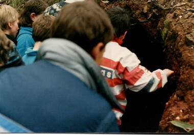
Photograph, School Camp, 1988
... The children from Bulla and MIckleham schools were attending a school camp at Beechworth and one of the activities was hiking in one of the nearby hills. While hiking they came across a tunnel which captured the attention of these children....Sunbury Global Learning Centre Macedon Street Sunbury melbourne The children from Bulla and MIckleham schools were attending a school camp at Beechworth and one of the activities was hiking in one of the nearby hills. While hiking they came across a tunnel which captured the attention of these children. school camps Hiking Beechworth A non-digital coloured photograph of four children looking into a tunnel, which is under an embankment. ...The children from Bulla and MIckleham schools were attending a school camp at Beechworth and one of the activities was hiking in one of the nearby hills. While hiking they came across a tunnel which captured the attention of these children.A non-digital coloured photograph of four children looking into a tunnel, which is under an embankment.school camps, hiking, beechworth