Showing 363 items matching "university land"
-
 University of Melbourne, Burnley Campus Archives
Poster, Nursery Display and Self Guided Tour, 1997-2007
... ...university of melbourne...Land...Produced by University of Melbourne, Land & Food Resources - Burnley Campus....Produced by University of Melbourne, Land & Food Resources - Burnley Campus. ...nursery, exhibition, display, tour, university of melbourne, land & food resources - burnley -
University of Melbourne, Burnley Campus Archives
Poster, The University of Melbourne, Nursery Display and Self Guided Tour, 1997-2007
... university of melbourne land & food resources...Produced by University of Melbourne, Land & Food Resources - Burnley Campus....Produced by University of Melbourne, Land & Food Resources - Burnley Campus. ...university of melbourne land & food resources, nursery, display, exhibition -
Federation University Historical Collection
Folders, University of Ballarat Procedures, Policies and Regulations Manual, 1996, 1996
... ...university land...Barker Library (top floor) Mount Helen goldfields university of ballarat policy university of ballarat regulations university o fballarat procedures rules equal opportunity policy areboretum health and safety equity policy affirmitive action plan sex neutral language guidelines ballarat technology park food crop development centre aquatics laboratory university establishment origins of the univeristy history ballarat isntitute of advanced education state college of victoria at ballarat merger ballarat college of advanced education tertiary education act campus development 1967-1993 naming of major buildings e.j. barker library ian gordon (education) building university land evolution of the university of ballarat academic board university of ballarat student association ltf m.b. ...Two white ring folders containing University of Ballarat containing Procedures, Policies and Regulationsuniversity of ballarat policy, university of ballarat regulations, university o fballarat procedures, rules, equal opportunity policy, areboretum, health and safety, equity policy, affirmitive action plan, sex neutral language guidelines, ballarat technology park, food crop development centre, aquatics laboratory, university establishment, origins of the univeristy, history, ballarat isntitute of advanced education, state college of victoria at ballarat, merger, ballarat college of advanced education, tertiary education act, campus development 1967-1993, naming of major buildings, e.j. barker library, ian gordon (education) building, university land, evolution of the university of ballarat, academic board, university of ballarat student association ltf, m.b. john building -
University of Melbourne, Burnley Campus Archives
Newspaper - Newspaper Cutting, The Age, The University of Melbourne, 2004-2006
... off course: from public place to market place at melbourne university...land...University" by John Cain and John Hewitt, R.J.W. Sellick Reviewer in "The Age" March 13, 2004. (2) "Classes Move" in "The Leader" March 2006. (3) "Land and Food Resources to refocus on higher education" in "Melbourne University Magazine" August 2005 p5....University of Melbourne, Burnley Campus Archives 500 Yarra Boulevard Richmond melbourne john cain john hewitt r.j.w. sellick off course: from public place to market place at melbourne university land and food resources higher education Collection of 3 newspaper articles. (1) "Private Income, public tension." ...Collection of 3 newspaper articles. (1) "Private Income, public tension." Review of book, "Off Course: From Public Place to Marketplace at Melbourne University" by John Cain and John Hewitt, R.J.W. Sellick Reviewer in "The Age" March 13, 2004. (2) "Classes Move" in "The Leader" March 2006. (3) "Land and Food Resources to refocus on higher education" in "Melbourne University Magazine" August 2005 p5.john cain, john hewitt, r.j.w. sellick, off course: from public place to market place at melbourne university, land and food resources, higher education -
University of Melbourne, Burnley Campus Archives
Document, Burnley Land Title Information, 1958-1998
... Copies of University of Melbourne and land titles, relating to FOBG Heritage listing of Burnley Gardens. 5 documents. ...University of Melbourne, Burnley Campus Archives 500 Yarra Boulevard Richmond melbourne heritage listing fobg land title burnley gardens Copies of University of Melbourne and land titles, relating to FOBG Heritage listing of Burnley Gardens. 5 documents. ...Copies of University of Melbourne and land titles, relating to FOBG Heritage listing of Burnley Gardens. 5 documents. Refer to paper catalogueheritage listing, fobg, land title, burnley gardens -
 University of Melbourne, Burnley Campus Archives
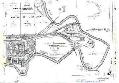
Plan, Allan & Tuxen et al, Public Park & Recreation Reserve (Richmond Park), 1886-1996
... Photocopy of plan of Richmond Park and Burnley Gardens with University of Melbourne land acquisition 13.10.1994 hand drawn on it, dates Act revoked and Gazette numbers. ...University of Melbourne, Burnley Campus Archives 500 Yarra Boulevard Richmond melbourne Shows changes in ownership of various parts of Richmond Park and Burnley Gardens including University of Melbourne, Amrad, Melbourne City Link, etc. from gazettal in 1873 to 1996 public parks recreation reserve richmond Parish if Jika Jika Burnley Gardens Horticultural Society of Victoria "Changes to ownership & boundaries of Gardens" in ink Photocopy of plan of Richmond Park and Burnley Gardens with University of Melbourne land acquisition 13.10.1994 hand drawn on it, dates Act revoked and Gazette numbers. ...Shows changes in ownership of various parts of Richmond Park and Burnley Gardens including University of Melbourne, Amrad, Melbourne City Link, etc. from gazettal in 1873 to 1996Photocopy of plan of Richmond Park and Burnley Gardens with University of Melbourne land acquisition 13.10.1994 hand drawn on it, dates Act revoked and Gazette numbers. Based on plan of Parish of Jika Jika R 19 (3)"Changes to ownership & boundaries of Gardens" in inkpublic parks, recreation reserve, richmond, parish if jika jika, burnley gardens, horticultural society of victoria -
 Federation University Historical Collection
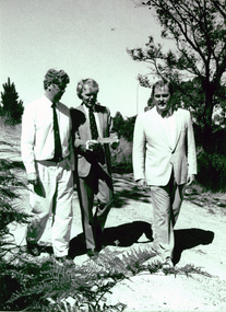
Photograph - Photograph - Black and White, Land Rehabilitation, 09/1991
... ballarat university college...centre for land...A major funds injection helped to establish the Ballarat University College Centre for Land Rehabilitation. The project was co-ordinated by Dr Leigh Sullivan...Barker Library (top floor) Mount Helen goldfields A major funds injection helped to establish the Ballarat University College Centre for Land Rehabilitation. The project was co-ordinated by Dr Leigh Sullivan ballarat university college centre for land rehabilitation leigh sullivan john sharpham michael ransom Black and white photograph showing three men strolling outdoors. ...A major funds injection helped to establish the Ballarat University College Centre for Land Rehabilitation. The project was co-ordinated by Dr Leigh SullivanBlack and white photograph showing three men strolling outdoors. The are (left to right) Michael Ransom (Assistant Regional Manager, Department of Conservation and Environment; Professor John Sharpham (Director of Ballarat University College) and Dr Leigh Sullivan (Co-ordinator of the National Soil Conservation Programme).ballarat university college, centre for land rehabilitation, leigh sullivan, john sharpham, michael ransom -
 Hume City Civic Collection
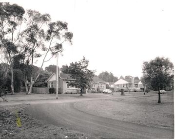
Photograph, c1970s
... After the asylum was closed down and the main asylum buildings were taken over by Victoria University, the surrounding land was developed for housing by the Urban Land Authority, the administrators houses were demolished....After the asylum was closed down and the main asylum buildings were taken over by Victoria University, the surrounding land was developed for housing by the Urban Land Authority, the administrators houses were demolished. sunbury asylum wishart chas. h. george evans collection Written on the back in penci: 1139-8l A black and white photograph of two bungalow style houses built along a formed but unsurfaced road. ...A number of houses were built within the Sunbury Asylum grounds to house administrators and staff, and their families, who worked at the asylum. After the asylum was closed down and the main asylum buildings were taken over by Victoria University, the surrounding land was developed for housing by the Urban Land Authority, the administrators houses were demolished.A black and white photograph of two bungalow style houses built along a formed but unsurfaced road. A Mini-minor car is parked on the grass outside the first house and a Holden sedan is parked by the curb outside the other house. There are trees growing along the nature-strip and in the background.Written on the back in penci: 1139-8lsunbury asylum, wishart, chas. h., george evans collection -
 Bendigo Historical Society Inc.
Document - FORTUNA COLLECTION: DOCUMENT
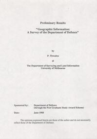
... Thwaites at The Deparment of Surveying and Land Information University of Melbourne. Sponsored by: Deparment of Defence (through the Post Graduate Study Award Scheme, Date: June 1988. ' Document is 17 single pages in length including a Contents page....Thwaites at The Deparment of Surveying and Land Information University of Melbourne. Sponsored by: Deparment of Defence (through the Post Graduate Study Award Scheme, Date: June 1988. ' Document is 17 single pages in length including a Contents page. ...Document - titled : Preliminary Results 'Geographic Information: A Survey of the Department of Defence' Additional written information on title page reads: 'by P. Thwaites at The Deparment of Surveying and Land Information University of Melbourne. Sponsored by: Deparment of Defence (through the Post Graduate Study Award Scheme, Date: June 1988. ' Document is 17 single pages in length including a Contents page. -
 Warrnambool and District Historical Society Inc.
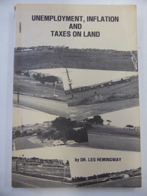
Book, Dr Les Hemingway, Unemployment, inflation & taxes on land, 1982
... land tax in Victoria. It was written by Dr Les Hemingway who was a fitter and turner who studied medicine at the University of Melbourne and came to Warrnambool in 1958. ...land tax in Victoria. It was written by Dr Les Hemingway who was a fitter and turner who studied medicine at the University of Melbourne and came to Warrnambool in 1958. ...This book details the problems caused by the low level of land tax in Victoria.This is a soft cover book of 152 pages. The cover is buff-coloured with a collage of black and white photographs on the front cover and a summary of the book on the back cover. There is black lettering on the cover and spine. The cover is a little torn and shows evidence of silverfish damage. The book is bound with three metal staples.non-fiction This book details the problems caused by the low level of land tax in Victoria.economic history, history of warrnambool, dr les hemingway -
 Bendigo Military Museum
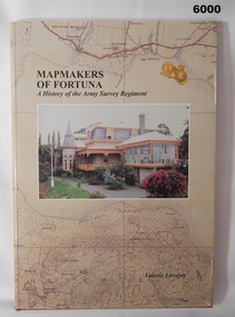
Book - Mapmakers of Fortuna, a History of the Army Survey Regiment, Ex Fortuna Survey Association Inc, 2003
... Covers the arrival of the Land Headquarters Cartographic Company at Fortuna Villa in 1942 until the disbandment of the Army Survey Regiment in 1996. Written by Valerie Lovejoy as part of her Masters degree at La Trobe University, Bendigo...Bendigo Military Museum 37 - 39 Pall Mall Bendigo goldfields Covers the arrival of the Land Headquarters Cartographic Company at Fortuna Villa in 1942 until the disbandment of the Army Survey Regiment in 1996. Written by Valerie Lovejoy as part of her Masters degree at La Trobe University, Bendigo Royal Australian Survey Corps RASvy Army Survey Regiment Army Svy Regt ASR On first page, "Donated to Bendigo RSL Museum by Ex Fortuna Survey Association Inc 21 April 2022" Unit History of the Army Survey Regiment by Valerie Lovejoy, ISBN: 0-646-42120-4, 234 pages, 9 Chapters, 6 Appendices, Black and White photographs, Colored map extracts, Colored cover jacket, hard cover, nominal roll of Unit members. ...Covers the arrival of the Land Headquarters Cartographic Company at Fortuna Villa in 1942 until the disbandment of the Army Survey Regiment in 1996. Written by Valerie Lovejoy as part of her Masters degree at La Trobe University, BendigoUnit History of the Army Survey Regiment by Valerie Lovejoy, ISBN: 0-646-42120-4, 234 pages, 9 Chapters, 6 Appendices, Black and White photographs, Colored map extracts, Colored cover jacket, hard cover, nominal roll of Unit members.On first page, "Donated to Bendigo RSL Museum by Ex Fortuna Survey Association Inc 21 April 2022"royal australian survey corps, rasvy, army survey regiment, army svy regt, asr -
Federation University Historical Collection
Document, Zelda Martin, Central Victorian Goldmining towns - Boom Towns or Ghost Towns?, c1996
... Friends of the State Library, 1989 +"The Public Lands of Australia Felix"; settlement and land appraisal in Victoria1834-91 with special reference to the Western Plains", J.M.Powell, Melb. Oxford University Press 1970 +*Bibliography of the Victorian Aborigines' from the earliest manuscripts to 31st December 1970, Massoa, Aldo, Melb. ...Friends of the State Library, 1989 +"The Public Lands of Australia Felix"; settlement and land appraisal in Victoria1834-91 with special reference to the Western Plains", J.M.Powell, Melb. Oxford University Press 1970 +*Bibliography of the Victorian Aborigines' from the earliest manuscripts to 31st December 1970, Massoa, Aldo, Melb. ...Zelda Martin was a PhD candidate at the University of Melbourne.[.1] 4th item in light blue display book titled Research Approach/Overview of Chapters/Confirmation of Canditure/Chapters1,2,3&4 of proposed thesis. *Twenty-seven page article on Victorian goldfields towns titled: Central Victorian Goldmining Towns - Boom Towns or Ghost Towns. The article was written during the author's PhD study. It outlines the context methodology, and resources and the chapters of the proposed thesis: (1) Central Victorian Goldmining Towns - The Context (2) Contemporary Views of the Factors Necessary for Town Growth (3) Outward Manifestations of Town Growth (4) The Trappings of Government (5-9) The Main Towns and Their Hinterland. [.2] 5th item in Light Blue display book as above item. *Chapter 1 of proposed thesis titled 'Pick, Shovel and Tin Dish Mining.' Covers in Section A: Central Victoria - Pre 1851: Aborigines in Central Victoria, Squatters, and Government. Section B: The years 1851-1854: The Early Gold Rushes, Government Reaction, Township Surveys, Legislation, Town Development, Local Government and Early Settlement. [.3] 6th item in Light Blue display book as above item. *2A of proposed thesis titled 'Contemporary Views of the Factors Necessary for Town Growth'. Similar information to Chapter 1 plus extra re towns and maps. Sections: Introduction, Context of Place - Geographical Towns Listed, The Context of Time - Pre1851 Aborigines, Governance of Port Phillip, The Squatters, The Villages of Central Victorian Highlands, Conclusion, Condensed Version of Chapter2B. [.4] 7th item in Light Blue display book as above item. *Chapter2B of proposed thesis. Sections: Area of Research, Schools, Banks, Newspapers, Progress Association, Town Development - Sandhurst (Bendigo), Ballarat, Castlemaine,, Maryborough, Ararat and Stawell. [.5] 8th item in Light Blue display book as above item. *Chapter 3 of proposed thesis titled 'Outward Manifestations of Town Growth'. Sections: Introduction, Contemporary Writing, Educationalists, The Bankers, The Townsfolk, Current Theory, General Theories of Urban Development, and Conclusion. [.6] 9th item in Light Blue display book as above item. *Chapter 4 of proposed thesis titled 'Trappings of Government' Sections: Introduction, Early Government Attitudes to Mining and Town Development, Law and Order, Township Surveys, Legislation, Local Government, Transport and Communication, The People and Lobbyists. [.7] 10th item in Light Blue display book as above item. *'The Rise and Fall of Central Victorian Goldmining Towns'. Includes a map showing main Goldfields, a table showing towns and villages at two points in time - 1857 and 1871; a Bibliography of Primary and Secondary Sources. [.8] Resource No1. Black display book titled Local Towns 1 : Alma: *Brief history *Directory *Maps Amphitheatre / Mountain Hut: *Brief History Post Office Directory Ararat: *Brief History *Post Office Directory 1869 - Alphabetical Listing by Occupation *Ararat - Prominent Citizens of 1858 *Langi-Morgala Museum Avoca: *Brief History *Excerpts from 'Avoca The Early Years', Margery and Betty Beavis; pg1 - Beginnings; pg11 - The Midas Touch; pg25 - Local Gold Escorts; pg27 - A Town is Born; pg51- The Administration of Justice; pg53 - The Ways of the Law; pg61 - News of the Day; pg65 - A Time to Play; pg72 - Land Ownership *Post Office Directory (Bailliere's) 1869 *Tourism Map and Information of area *Historic Avoca - A 5.5km Tour *Avoca & the Pyrenees Region - information pamphlet Ballarat: *Early History of Ballarat - Ballarat Historical Society, Publication No.1: origin of the name; Ballaarat - the Beginning; Fabulous Yields from the Ballaarat Goldfield; *Streetscape Lydiard Street. *Hand drawn map showing Leigh River, Old Portland Bay Road, plaque on road to Colac; etc. *Newspaper article re 'The Theatre Royal' ( which stood in the vicinity of the current Owen Williams store) - 'The News'15/04/1998 *Article - 'Ballarat's Mechanics' Institute Lives On' Ballarat Courier, 14/09/1985 *Article - Standing the Test of Time' The News 17/11/1993 re The Mechanics Institute & picture of the Reading Room *'Ballarat a Study of a City, Phyllis Reichl, pub. Nelson, 1968; no.3 place, time and people field studies series *Investigator Vol.33 No.2, 1998 Geelong Historical Society. Article on pg75 describes Ballarat in 1861 *Folded poster - 'Ballarat 100' a history of telegraph communication, pub. Telecom. Beaufort (Fiery Creek): *Brief history *Post Office Directory [.9] Resource No.2 Black Folder Titled Towns cont.No2 Bendigo (Sandhurst): *'Family & Local History at the Bendigo Library - 1851-2001 150 years of gold'. *Bendigo Government Camp in 1853 illustration; key to sketch and names of Government officers stationed there *Excerpts from 'Bendigo and Vicinity' Adolph Haman *The Bendigo Goldfield Registry - pgs 1-7 Introduction *Excerpt: 'Breaking the Grip' *Excerpt: The Most Go-Ahead Place *Excerpts from 'History of Bendigo' - anti license agitation; laying out of town; proposed railway; gold calls and dividends; the Sandhurst Municipality; journalism *Bibliography Blackwood: *Excerpts from 'Aspects of Early Blackwood - The Goldfield, the Landmarks, the Pioneers' Alan J Buckingham and Margaret F Hitchcock, JG Publishing,1980 Buninyong: *A Brief History *Investigator Vol1 No.2 Feb 1966 Geelong Historical Society. Pg3 - Article re gold escort route - Mt Alexander to Adelaide - (see a simple monument on the Western Highway a few miles out of Horsham. Pg 15 - Ballarat Excursion - re the finding of gold. *Three articles published by Buninyong and District Historical Society Inc: (Magpie Exploration; Finding Gold In The Green Hills; Magpie Exploration; Burnt Bridge to Cargarie to Mt Mercer) *Copies of newspaper articles/items *Buninyong Street Directory Carisbrook: *In the Beginning There Was Carisbrook *The History of the Carisbrook Racecourse Carngham / Snake Valley: *Brief History *Directory Castlemaine: *Directory 1865-1866 - Alphabetical and Street *Poster - Castlemaine A Contemporary Guide "The Great Centre" 1866 - A Contemporary Guide to the Fascinating Past *Pamphlet - Castlemaine District Community Hospital *Map - Castlemaine, Maldon & Surrounding Districts *Map and Information - The Dry Diggings Track - a 55kl walk among historic goldfields relics ( Castlemaine Fryerstown Vaughan Mt Franklin Hepburn Daylesford) *Postcard - Former Court House *Directory 1867 - Alphabetical, Trade [.10] Resource No.3 Grey folder Titled Towns 3 Creswick to Maryborough Creswick: *Brief History *Booklet - "Creswick Cemetery Walk" *Booklet - The Buried Rivers of Gold Heritage Trail Creswick *Creswick Historical Museum Information Sheet *Chronological History of Creswick *Alphabetical Directory of the Borough of Creswick *Creswick's Creek Directory 1856 *Historic Creswick Walking Tour *A Brief Account of the Schools of Creswick - Past and Present *100 Years of Railway Travel in Creswick *The Berry Deep Leads *The Spence Home at Jackass Gully in the Creswick State Forest ( William Guthrie Spence - Pioneer) *The New Australian Mine and the 1882 Disaster *Creswick District News, Issue 7, July August 1999 *The Creswick Miners Walk - Information and Map *Maps Chewton: *Brief History *Directory Clunes: *Brief History *Clunes Street Directory Daylesford: *Brief History *Notable Bushfires in Daylesford District Over More Than a Century - "Black Thursday" 1851; 1862; 1899; the Disastrous Hepburn Fire of 1906; 1939; 1944; 1969. *Post Office Directory -Daylesford and Hepburn Dunolly / Inkerman: *Brief History *Directory *Pamphlet - Goldfields Historical Museum *Pamphlet - Historic Dunolly - Victoria's Best Kept Secret *Map of Gold Workings at Dunolly Area - showing where the main gold rushes occurred *Brief History - Inglewood *Directory - Inglewood - Name Occupation, Dwelling Kingower: *Brief History *Directory - Name / Ocupation / Dwelling Linton / Happy Valley / Piggoreet: *Brief History *Directory - Lintons McIvor: *"A History of the Shire and the Township of Heathcote" by J.O. Randell Majorca: *Brief History *Official Post Office Directory 1869 - Name / Occupation/ Address Maldon (Tarrangower): *Brief History Part 1 *Brief History Part 2 *Post Office Directory *List - Alphabetical Order by Names plus Business and Trade (Tarrangower Times Oct/1858) *List - Alphabetical Order by Trade plus Name and Business *Directory - Name / Occupation / Dwelling Maryborough: *Worsley Cottage - built by Arthur Worsley, a contractor in stonework in 1894 [.11] Resource No. 4 Blue Display Book titled Towns 4 Moliagul to Stawell Moliagul: *Brief History *Moligul Legislative Assembly (Voting?) List - Names and Occupations *Moliagul Victorian Post Office Directory 1868 - Name / Ocupation / Address / Comments *"The Welcome Stranger" gold nugget *The Sunday School *The Welcome Stranger Discovery Walk - information and map Moonambel (Mountain Creek) Redbank *Brief History *List of names extracted from advertisments of the Pioneer and Mountain Creek Advertiser 16/02/1861. *Bailliere's Directory 1869 - Alphabetical List of Name / Occupation / Place St Arnaud: *Brief History Sebastapol: *Brief History *Directory 1869 - Alphabetical by Name; plus occupation and address. Browns and Scarsdale: *Brief History *Browns Street Directory - Name and Occupation Smythesdale: *Brief Description *Smythesdale Street Directory -Name and Occupation Stawell (Pleasant Creek) *Brief History *Victorian Official Post Office Directory - Name /Occupation / Dwelling *Chronology - 1841-1920 *Production of gold statistics - 1879 - 1900 *Big Hill *Extracts from "The Golden Years of Stawell". Chapt 1 - Stawell's Coming Out. Capt. 2 - The Gold Rush. Caapt.3 - Cradle of Democracy. Chapt.4 - The Reefs Becomes Stawell. Chapt. 5 - Rushing In. Chapt.6 - The Pioneers. Chapt 7 - The Decade of Optimism. [.12] Resource No. 5: Blue Display Book titled 'Towns Steiglitz to the The Golden Triangle. Steiglitz: Brief History Victorian Post Office Directory 1869 *Map of Steiglitz *List of maps relevant to Steiglitz history *Information 6 tables of data from "Reports of Mining Surveyors Talbot (Back Creek) Brief History Taradale: Post office Directory 1869 - Name/Occupation/Street. Also list in alphabetical order by Occupation Taradale *Chronological Reference to Taradale Mines *Water - The Coliban System of Waterworks *Joseph Brady *The Syphon Tarnagulla (Sandy Creek) *Brief History *Tarnagulla Businessmen Cameos to give depth to advertisments in 'The Tarnagulla Courier' various issues 1864-1871 *Directory - Name/Occupation /Address *List - Name/Business/Trade Wedderburn (Koorong) *Brief History *List - Name/Occupation The Golden Triangle: *The Early Rushes - Wedderburn / Moliagul / Sandy Creek - Tarnagulla / Jones Creek - Waanyarra / Kingower / Dunolly - Goldsborough / Inglweood *Census of 1857 - Population / Occupations *1858-1871 - A Time of Consolidation- Wedderburn / Moliagul / Sandy Creek- Tarnagulla / Arnold *Census 1871 - Population *Information gleaned from the census data - Demographics / Population / Occupations / marital / Birthplace / Religion / Literacy/ Occupation and Housing Cameos *Graphs - Birthplace of settlers /Male-Female Ratio / Married males / Children under 15 as Percentage of Population / Religion *Census 1857 - Statistical data *Maps *Bibliography [.13] Resource No. 6 - Black Display Book Information and Research in Central Victoria including: *Banking - Research from ANZ Bank Archives *Institutions - also includes articles listed from the Ballarat Times Newspaper *Australian mining History Association - A.M.H.A. Bibliography *Australia's Mining History * Bibliography - Land Surveys Victoria - *1853 Administration (Statistics and Other) includes: schools / ministers of religion / police / military / local administration / licences for sale of spirits / distances between various Victorian gold fields. * Victoria Government Gazette (Copy) - N0. 116, 12/12/1854 includes: Gold Felds Commission of Enquiry & No. 85, 15/09/1854 - Addresses presented to the Lieutenant Governor (Sir Charles Hotham) during his tour through the Gold Fields of Victoria,1854. Addresses on behalf of : the people of Bendigo; Members of the Church of England, Bendigo; Members of the Wesleyan Church on the Bendigo Gold Fields; Bendigo Gold District General Hospital; the Bendigo Prospecting Association; Committee of the Bendigo Local Exhibition; Bendigo District Medical Association; Coloured Americans Resident at Bendigo; German Inhabitants of Bendigo; Landowners, Inhabitants, and Miners of Castlemaine; Inhabitants of Forest Creek; Inhabitants of Heathcote and Gold Miners of McIvor; Residents and landholders of the District of Bacchus Marsh; Inhabitants of Kilmore and Vicinity. *Gold Fields Correspondence 1853: letter from Lieutenant Colonel Valiant, (Officer commanding the Troops in Victoria) to the Lieutenant Governor re threatened disturbance at Sandhurst (Bendigo) regarding the Gold License Fee. * Extracts from a book "Victoria" re Gold Fields Commission of Enquiry involving mainly Ballarat and Castlemaine and a chapter titled 'A Tour to the Victorian Gold-Fields' *Lists of central Victorian newspapers - listed by date published 1851to 1874; by first date available to State Library. *A list of cities and towns showing County, population in 1861 &1871, and municipal status. [.14] Resource no.7. Black display book. *Reference: Papers presented to Parliament Victoria - 1859-1860 4 volumes - relevant sections copied. Contains information on Branches of Government. General / Finance / Gold / Gazette / Commission and Warrant / Statistic. *Gold Fields Act. In accordance with the Act the gold fields are divided into six districts - Ballaarat, Castlemaine , Sandhurst, Avoca, Ararat, and Beechworth.. Official staff in each gold district consists of a Resident Warden, Wardens, Wardens' Clerks, Bailiffs, Chinese Protectors, Chinese Interpreters, and Mining Surveyors. *Gold Receiver *Gaols *Police magistrates and Clerks of Petty Sessions, etc. *Field Branch *Immigration and Emigration Overland - Chinese - 1859 *Population on the Goldfields *The Geological Survey - The Government Geologist is assisited by staff from four branches - the office Branch; the Publishing Branch; the Field Branch and the Museum Branch. *Commission to Enquire Into Sludge dated 10/02/1859 (Some sections copied) - Report to the Honorable Chief Commissioner of Public Works, Melbourne re the mode of carrying the sludge from the puddling mills in Sandhurst without interfering with the drainage of the town and the roads in the neighbourhood. [.15] Resource No.8: Camel display book titled Resource No. 8. Aborigines *Lists of book titles - +"Readings in Victorian prehistory" +"The Aborigines of Port Phillip" +Aboriginal languages and clans" +"A History of the Port Phillip District" +"Langi Ghiran 1: Aboriginal Rock...." +"Koorie History: sources for aboriginal studies in the State Library of Victoria", ed. Tom Griffiths, Melb. Friends of the State Library, 1989 +"The Public Lands of Australia Felix"; settlement and land appraisal in Victoria1834-91 with special reference to the Western Plains", J.M.Powell, Melb. Oxford University Press 1970 +*Bibliography of the Victorian Aborigines' from the earliest manuscripts to 31st December 1970, Massoa, Aldo, Melb. Hawthorn Press, 1971 +"Aborigines in Colonial Victoria, 1836-1886", M.F. Christie, Sydney University Press, 1979 +"Urban and Industrial Australia: readings in Human Geography" ed J.M. Powell, Melb. Sorrett Pub. 1974 *Extracts: -Processes of Pioneer Settlement - The Squatting Occupation of Victoria, 1834-60. J.M. Powell -Areal Variations in the Class Structure of the Central-Place Hierarchy. P. Scott - Volume1 and Volume 2: Notes Relating to the Habits of the Natives of Other Parts of Australia and Tasmania. Compiled from various sources for the Government of Victoria by R Brough Smyth. John Curry, O'Neil, Melb. 1st pub. Melb. 1876. p31-45 - Numbers and Distribution of the Aborigines in Victoria -Victorian Aborigines 1835-1901 - A Resource Guide to the Holdings of the Public Record Office, Victoria; published by the Government Information Centre 1984. *History of the Aboriginal Artefacts Displayed in the Daylesford Museum. F. G. Powell (4 page pamphlet) *Letter to Zelda Martin from Peter Lovett, Cultural Officer, Ballarat & District Aboriginal Co- Operative, 05/02/1997 *Map: Ian Clarke Victorian Tribunal Boundary Map - Clans of Central Victoria. *Victorian Rock Art and Mythology - Article about Mount Langhi Ghiran and myths of the Tjapwarong people. *Two Aboriginal myths relating to the Grampians - 'The Monster Emu' / 'The Aquisition of Fire', by the Aborigines in the Grampians Areas *Article titled (chapter 8) Ballarat - information re camping sites in the region. Lake Wendouree / Lake Burrumbeet (includes a myth) / Mt Bunninyong / Lal Lal / Pitfield / Mount Elephant / Mount Egerton / Meredith / Lake Goldsmith / Lake Learmonth / Ercildoune *Notes on the Aborigines of the Wider Ballarat Region plus European names=Aboriginal names. John Morris 26/07/1995 *Role of Aborigines in Town Development in Central Victoria. Mentions Native Police Force est. in Port Phillip 1842 and Central Board for Aborigines est. 1860 *The Grave of King Billy. (Frank Wilson) Pamphlet. *Camping Places in Central and Northern Victoria. Article re Lake Burrumbeet site. *Programme for the Unveiling of Memorial Cairn for Edward Stone Parker 1802-1865. Note portrait not accurate. Accurate portrait is available in the book "A Successful Failure A Trilogy The Aborigines and Early Settlers", Edgar Morrison, Graffiti Publications, 2002. * Large envelope addressed to Mr G Netherway containing newspaper cuttings regarding the life of Edward Stone Parker, the unveiling of the Memorial Cairn as mentioned above, articles titled 'Episodes from Our Early Days' (Edgar Morrison, Yandoit)- The Black's School, A School At Last and The Final years. Also a typed page titled 'Historical Background to E.S.Parker's Career. Includes an interesting tale titled 'When the cat lay doggo' re laying power leads for the unveiling ceremony at the memorial site. [.16] green display folder titled 'Research Aids' *List of references to Commissioners' & W'ardens' Reports (formerly held at La Trobe Library Archives, now at Public Records Office [PRO]). Indicates town referred to / date of report / name of camp if different to town. * Archive information re Anglican Records *Movement around the Goldfields - Miners and Storekeepers - usefulness of newspapers in providing information - areas covered - Castlemaine, Maldon, Ararat, Stawell, Tarnagulla, Dunolly. *Port Phillip /Victoria Directories 1839/1867 - Chronological list of Directories included in this series. *"Notes on the History of Local Government in Victoria" A.W. Greig Melb. University Press 1925 - Photo-copied extract p5-p40. (Source - Deakin University Library) - Introduction by W.Harrison Moore. Section 1 - Development in New South Wales Before Separation. Section 2 - Development in Victoria After Its Separation from New South Wales. Hand written notations: 'roads, markets, and local government 1855 on' ;'opportunity of squatters in parliament' and 'opportunities of matters in parliament p33' * Notes on the Establishment of Surveyor General's Department 1851and Commissioner of Crown Lands and Survey. * Newspaper articles from The Argus, 1849, re the discovery of gold in the Pyrenees region. * Excerpt - a report on schools - A.B.Orlebar, Inspector; re the need for permanent school buildings rather than tents. *Excerpt from - 'Approaches to Urban History', Sean Glynn: The Case for Caution * Except from - 'The Urban Sprinkle', Weston Bate: Country Towns and Australian Regional History *Reference- 'The History of Land Tenure in the Colony of Victoria', John Quick. References the Haines Land Bill, land tenure and Land Leagues. [.17] Light blue envelope folder titled 'Birtchnell's Ballarat, etc. Directory 1862 *Contains various directories for Smythesdale, Buninyong, Clunes, Brown's and Creswick. [.18] Red envelope folder no.2 titled Victorian Gazetteer *Selected pages from 1869 Victorian Gazetteer on A4 paper (with a handwritten note questioning if some pages are from 1868 Victorian Gazetteer as appears to be different sizes - A3 pages.) Information includes locations and descriptions of towns, hotels, banks, communications and populations. (Does not include names, residences and occupations) [.19] Red Envelope folder titled Bailliere's Official Post Office Directory 1868 (or1869 or a mixture of both?) *Preface *Contains a selection of pages of towns highlighted in yellow in the the index *Work on this directory was commenced in 1867. *Information includes: Municipalities - mayors and councilors; lists of towns naming male inhabitants and their occupations. [.20]Yellow manila folder titled Post Grad Seminar Presentation 1996 *Gives some background to Zelda Martin's proposed thesis and why she chose the topic Gold Mining Towns Boom or Bust [.21] A3 display book - No. 1A * A list of 'Relevant Newspapers collected: The Tarrangower Times and Maldon Advertiser (first published 1858) Includes dates 1858-1867. The Mount Alexander Mail. Includes dates 1854-1866 The Tarnagulla Courier. Includes dates from1864-1871 Dunolly and Burnt Creek Express. Includes dates from 1862-1871 * Selection of newspaper pages from The Mount Alexander Mail 1854 to 1856, mostly showing advertisements for businesses and services provided to that community. [.22] A3 display book - No. 1B * Selection of newspaper pages from The Mount Alexander Mail 1857 to 1866, mostly showing advertisements for businesses and services provided to that community. [.23] A3 display book -No. 2 * Selection of newspaper pages from The Tarnagulla Courier 1864 to 1871, mostly showing advertisements for businesses and services provided to that community. [.24] A3 display book - No. 3 *Selection of newspaper pages from The Tarrangower Times (and Maldon and Newstead) Advertiser 1858 to1867, mostly showing advertisements for businesses and services provided to that community. [.25] A3 display book - No.4 * Selection of newspaper pages from The Dunolly and Burnt Creek Express; and The Dunolly and Betbetshire Express 1862 to 1871, mostly showing advertisements for businesses and services provided for that community. [.26] A3 display book - No.5 Includes: * Bryce Ross's Diggings Directory. Includes instructions for using this directory. This directory was used by "all persons having connexion or desiring to communicate with 'working parties, private friends, or Stores at the Diggings." As a directory for each area wwas completed it was published in each month's issue of Bonwick's "Digger's Magazine." Years c1852/1853. This Directory commences first at the head of Forest Creek. Includes a directory for Bendigo and Ballarat. Of interest at the end of the Bendigo and Ballarat directory is a list of the number of storekeepers, butchers, doctors, smiths, eating houses, lemonade sellers and chapels. * The Castlemaine Directory and Book of General Information Comprehending Glass's Model Calendar for the Two Years 1862 and1863. "zelda martin, victorian goldfield towns, bendigo, castlemaine, ballarat, maldon, stawell, ararat, maryborough, creswick, avoca, heathcote, banks, bank of australasia, union bank of australia, government camp, sandhurst, water supply, tarnagulla, talbot, back creek, mountain creek, police court, carisbrook, dunolly, thompson's foundry, charles clacy, anthony trollope, robert cecil, mount alexander, urbanisation, national schools, education, govenrment, industry, railway, transport, settlement, land settlement in central victoria, steiglitz, joseph brady, the new australian mine, berry deep leads, william guthrie spence, creswick state forest, arthur worsley, worsley cottage, the welcome stranger, moliagul, moonambel, redbank, st arnaud, sebastapol, brown's, scarsdale, clunes, chewton, daylesford, bushfires, inkerman, inglewood, kingower, lintons, happy valley, piggoreet, mcivor, majorca, tarrangower, taradale, the coliban system, the syphon, sandy creek, wedderburn, koorong, arnold, jones creek, waanyarra, the golden triangle, census 1857, blackwood, buninyong, durham lead, magpie, carngham, snake valley, alma, amherst, daisy hill, amphitheatre, mountain hut, beaufort, fiery creek, counties, population, gold fields commission of enquiry1854, william westgarth, gold license fee, lieutenant colonel valiant, administration of the victorian gold fields, commission to enquire into sludge 1859, e.s. parker, edward stone parker, edgar morrison, mount franklin protectorate, dja dja wurrung, memorial cairn, franklinford, mt franklin memorial cairn, jajowurrong, dja dja wurung, tjaowarong, wothowurong, assistant protectors, daylesford museum, buluk, rock art - grampians, aboriginal mythology - grampians, aborigines, first nations people, mount franklin, aboriginal artifacts, lake burrumbeet, native police force, central board of aborigines, yandoit, commissioners' reports, wardens' reports, port phillip/victoria directories 1839-1867, local government - victoria 1853/1854, surveyor general's department - 1850's, victorian schools 1850's, a.b.orlebar, haines land bill, william charles haines, wilson gray, land tenure, land leagues, victorian gazetteer, the tarrangower times and maldon advertiser - 1858-1867, the mount alexander mail 1854-1866, the tarnagulla courier 1864, dunolly and burnt creek express 1862-1871, bryce rose's diggings directory, the castlemaine directory 1862-1863 -
Federation University Historical Collection
Document, Ballarat School of MInes Memorandum of Association
... University Australia E.J. Barker Library (top floor) Mount Helen goldfields ballarat school of mines memorandum of association land allotments Signed on front 'R. ...Ballarat School of MInes Memorandum of AssociationSigned on front 'R. Hollioake'ballarat school of mines, memorandum of association, land allotments -
 Federation University Historical Collection
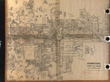
Plan, Department of Crown Lands and Survey, Melbourne, Buninyong County of Grant, 23/07/1929
... University Australia E.J. Barker Library (top floor) Mount Helen goldfields The plan was photo-lithographed at the Departmen tof Lands and Survey, Melbourne Buninyong Scotchman's Mt Buninyong Robert Scott Clarendon Lal Lal Creek yendon warrenheip Yarowee Enfield Thomas Learmonth John Learmonth Archibald Fisken G. Schloo George Innes Peter Inglis Durham Lead J. Fry J. Forrest Parkin Lee Buninyong Recreation Reserve A parish plan of Buninyong, including Robert Scott's Mt Buninyong Pre-emptive Right, Mt Buninyong Public Park, Thomas Learmonth's land ...The plan was photo-lithographed at the Departmen tof Lands and Survey, MelbourneA parish plan of Buninyong, including Robert Scott's Mt Buninyong Pre-emptive Right, Mt Buninyong Public Park, Thomas Learmonth's land, John Learmonth's land, Scotchan's, Yendon. The Buninyong POst Office is Allotment 1. Pisition of tracks in 1859 have been marked on the plan in red.buninyong, scotchman's, mt buninyong, robert scott, clarendon, lal lal creek, yendon, warrenheip, yarowee, enfield, thomas learmonth, john learmonth, archibald fisken, g. schloo, george innes, peter inglis, durham lead, j. fry, j. forrest, parkin lee, buninyong recreation reserve -
 Federation University Historical Collection
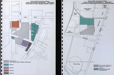
Document, Documents relating to land aquisition for School of Mines and Industries Ballarat
... Barker Library (top floor) Mount Helen goldfields School of Mines and Industries Ballarat is a predecessor of Federation University School of Mines and Industries Ballarat Land Aquisition Car parking Diagrams relating to land aquisition for School of Mines and Industries Ballarat. ...School of Mines and Industries Ballarat is a predecessor of Federation University Diagrams relating to land aquisition for School of Mines and Industries Ballarat.school of mines and industries ballarat, land aquisition, car parking -
 Federation University Historical Collection
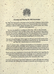
Document - Document - Letter, VIOSH: University of Ballarat; "Growing and Sharing the OHS Knowledge" - 25 years Celebration, 2004
... University of Ballarat, Mount Helen. The seedling was planted in 1896 by Mrs Elizabeth Downing who lived on what was their farm. The land...University of Ballarat, Mount Helen. The seedling was planted in 1896 by Mrs Elizabeth Downing who lived on what was their farm. The land ...Victorian Institute of Occupational Safety and Health (VIOSH) Australia is the Asia-Pacific centre for teaching and research in occupational health and safety (OHS) and is known as one of Australia's leaders on the field. VIOSH has a global reputation for its innovative approach within the field of OHS management. VIOSH had its first intake of students in 1979. At that time the Institution was known as the Ballarat College of Advanced Education. In 1990 it became known as Ballarat University College, then in 1994 as University of Ballarat. It was 2014 that it became Federation University. VIOSH Australia students are safety managers, senior advisors and experienced OHS professionals. They come from all over Australia and industry. Students are taught active research and enquiry; rather than textbook learning and a one-size fits all approach. VIOSH accepts people into the Graduate Diploma of Occupational Hazard Management who have no undergraduate degree - on the basis of extensive work experience and knowledge. Letter gives the history of the "Big Tree" at the heart of the University of Ballarat, Mount Helen. The seedling was planted in 1896 by Mrs Elizabeth Downing who lived on what was their farm. The land was purchased in 1966 as part of a site for the location of the new campus It was decided that the tree should remain as a central landmark.Letter typed on cream flecked paper - A4 size. Image of tree A4 card, folded into three, deep burgundy. Letter attached with small packet of seeds. These have been removed.viosh, victorian institute of occupational safety and health, university of ballarat, mount helen, big tree, elizabeth downing, 1896, 1966 -
Federation University Historical Collection
Photograph, Opening of the Alcoa Laboratory, 1995, 08/12/1995
... University Australia E.J. Barker Library (top floor) Mount Helen goldfields Alcoa Laboratory Martin Westbrooke Geoffrey Colemen John Hannagan Alcoa Laboratory for Soil and Land Management Four photographs from the opening of the Alcoa Laboratory for Soil and Land Management on the Mount Helen Campus Opening of the Alcoa Laboratory, 1995 Photograph Photograph ...Four photographs from the opening of the Alcoa Laboratory for Soil and Land Management on the Mount Helen Campusalcoa laboratory, martin westbrooke, geoffrey colemen, john hannagan, alcoa laboratory for soil and land management -
Federation University Historical Collection
Document - Document - Syllabus, Education Department, Victoria,Technical Schools, Syllabuses
... University Australia E.J. Barker Library (top floor) Mount Helen goldfields Technical Schools Syllabuses produced by the Education Department of Victoria. Items cover the period between 1914 and 1948. They outline the requirements for various subjects, covering the following: .1: Sound and Light; .2: Course for Public Analysts, Day and Evening; .3: Sheet Metal Work; .4 Land, Engineering and Mine Surveying (1914); .5: Surveying (1921); .6: Physics (1924); 7: Iron, Steel and Engineering Alloys (1924); .8: Instrument Making(1924); .9: Elementary Science (1924); .10: Shorthand (1925); .11: Elementary Science- for Girls (1926); .12: Physic- Women's School (1928); .13: Typewriting (1929); .14: Painting and Decorating (1929); .15: Plumbing and Gasfitting (1929); .16: Plastering (1929); .17: Signwriting (1929); .18 Plumbing and Gasfitting (1937); .19: Course for Fibrous Plastering (1937); .20: Plumbing and Gasfitting (1938); .21: Course for Fitting and/or Turning and Machinist (1948). ...Technical Schools Syllabuses produced by the Education Department of Victoria. Items cover the period between 1914 and 1948. They outline the requirements for various subjects, covering the following: .1: Sound and Light; .2: Course for Public Analysts, Day and Evening; .3: Sheet Metal Work; .4 Land, Engineering and Mine Surveying (1914); .5: Surveying (1921); .6: Physics (1924); 7: Iron, Steel and Engineering Alloys (1924); .8: Instrument Making(1924); .9: Elementary Science (1924); .10: Shorthand (1925); .11: Elementary Science- for Girls (1926); .12: Physic- Women's School (1928); .13: Typewriting (1929); .14: Painting and Decorating (1929); .15: Plumbing and Gasfitting (1929); .16: Plastering (1929); .17: Signwriting (1929); .18 Plumbing and Gasfitting (1937); .19: Course for Fibrous Plastering (1937); .20: Plumbing and Gasfitting (1938); .21: Course for Fitting and/or Turning and Machinist (1948). This is a 48 page booklet. 21 A5 sheets typedtechnical schools, syllabuses, victoria, education department, sound and light, public analysts, sheet metal work, land engineering and mine survey, surveying, physics, iron steel and engineering alloys, instrument making, elementary science, shorthand, elementary science for girls, physics women's schools, typewriting, painting and decorating, plumbing and gasfitting, plastering, signwriting, fibrous plastering, fitting and/or turning, machinist, 1914, 1921, 1924, 1925, 1926, 1928, 1929, 1937, 1938, 1949 -
 Orbost & District Historical Society
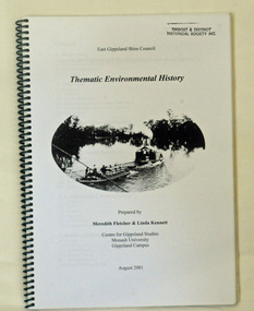
book, Thematic Environmental History, 2001
... University, Gippsland Campus. On the front cover is a black and white drawing of a paddle steamer towing a barge along a river. It contains information on the discovery, settlement and land usage of East Gippsland as well as the development of transport, communication and cultural institutions. ...University, Gippsland Campus. On the front cover is a black and white drawing of a paddle steamer towing a barge along a river. It contains information on the discovery, settlement and land usage of East Gippsland as well as the development of transport, communication and cultural institutions. ...This booklet was prepared for the East Gippsland Shire Council in August 2001.A Thematic Environmental History identifies how key patterns of development have influenced the culture of the area and the natural and built environment. The document is not a social history but usually provides the context for future heritage studies and assessments and would provide input to the preparation of a Heritage Action Plan. This booklet prepared for the East Gippsland Shire councilA spiral bound book of 75 pp, titled Thematic Environmental History, prepared by Meredith Fletcher and Linda Kennett for the Centre for Gippsland Studies, Monash University, Gippsland Campus. On the front cover is a black and white drawing of a paddle steamer towing a barge along a river. It contains information on the discovery, settlement and land usage of East Gippsland as well as the development of transport, communication and cultural institutions. Copywright held by East Gippsland Shire Council and Department of Infrastructureenvironmental-study-east-gippsland -
 Federation University Historical Collection
Document, SMB: Catalogue of a Collection of Rocks, Minerals, etc, 1883
... University Australia E.J. Barker Library (top floor) Mount Helen goldfields This list of rocks, minerals, etc. from Victoria was complied and forwarded by the School of Mines, Ballarat, to the Calcutta International Exhibition. At the end of the exhibition the items were to be presented to the Geological Survey of India. One Hundred items are listed. Pages 4 and 5 also show diagrams relating to the land ...This list of rocks, minerals, etc. from Victoria was complied and forwarded by the School of Mines, Ballarat, to the Calcutta International Exhibition. At the end of the exhibition the items were to be presented to the Geological Survey of India. One Hundred items are listed. Pages 4 and 5 also show diagrams relating to the land formations and sections. Places in Victoria are named indicating where items were found. List compiled by Professor Ferdinand Moritz Krause. He joined Ballarat School of Mines in 1880 and lectured in Mineralogy and Geology. He was also the Curator of the Ballarat School of Mines Museum.6 pages, handwrittenSignature of F M Krause Dated 30th August 1883ballarat school of mines, rocks, minerals, calcutta international exhibition, geology survey of india, victoria, professor ferdinand moritz krause, mineralogy, geology, curator, ballarat school of mines museum -
 Federation University Historical Collection
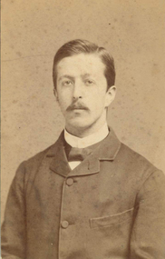
Photograph, John William Lindt, Miles Barraclough, Head teacher of Happy Valley School, c1884, c1884
... University Australia E.J. Barker Library (top floor) Mount Helen goldfields Happy Valley was originally called Lucky Woman's. The School opened under the name of Happy Valley in 1883, and the brick building probably dates from that time. Miles Barraclough was the head teacher from 1873 to 1887. When mining ceased the population declined and the land ...Happy Valley was originally called Lucky Woman's. The School opened under the name of Happy Valley in 1883, and the brick building probably dates from that time. Miles Barraclough was the head teacher from 1873 to 1887. When mining ceased the population declined and the land reverted to grazing. The School closed in 1940. (Visions and Realisations)Sepia photo of Happy Valley School Teacher, Mr Miles BarracloughVerso Handwritten "Sept-84 Mr Barraclough School teacher Happy Valley" Printed "From J.W. Lindt Photographer Prize Medalist Philadelphia Paris Sydney Brisbane Sandhurst Melbourne 7 Collins Street East Melbourne.happy valley, happy valley school, barraclough, j.w. lindt, miles barraclough, miles barrowclough, lucky woman's, myles barraclough, happy valley school principal -
Federation University Historical Collection
Document, Crown Lands in Villiers and Westward Counties, 1856-7, 1856-7
... Federation University Historical Collection Federation University Australia, Mt Helen Campus Federation University Australia E.J. Barker Library (top floor) Mount Helen goldfields land land sales villiers heytesbury hampden normanby dundas follett crown lands Blue foolscap printed Government document lon Crown lands in Villiers and Westward Counties. ...Blue foolscap printed Government document lon Crown lands in Villiers and Westward Counties. It inlcudes the return shoiung number of acres of land sold and the amount received for same. land, land sales, villiers, heytesbury, hampden, normanby, dundas, follett, crown lands -
Federation University Historical Collection
Document, Crown Lands Act, 1862, 1862
... Federation University Historical Collection Federation University Australia, Mt Helen Campus Federation University Australia E.J. Barker Library (top floor) Mount Helen goldfields land land sales crown land ararat petition Blue foolscap printed Government document on the Crown Lands Act. ...Blue foolscap printed Government document on the Crown Lands Act. land, land sales, crown land, ararat, petition -
Federation University Historical Collection
Document, Mining on Police Paddock, Beaufort, 1862-3, 1862-1863
... University Australia E.J. Barker Library (top floor) Mount Helen goldfields beaufort beaufort police paddock mining t. pratt j.h. kay crown land Blue foolscap printed Government document relating to the police paddock at Beaufort, Mining on Police Paddock, Beaufort, 1862-3 Document John Ferres John Ferres ...Blue foolscap printed Government document relating to the police paddock at Beaufort,beaufort, beaufort police paddock, mining, t. pratt, j.h. kay, crown land -
 Federation University Historical Collection
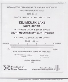
Map - Geological, Kejimkujik Lake, Nova Scotia: Glacial and Till Clast Geology: Map 94-12, 1994
... University Australia E.J. Barker Library (top floor) Mount Helen goldfields Produced b Nova Scotia Department of Natural Resources, Mines and Energy Branches. The Minister of the Department was the Honourable Donald R Downe and the Deputy Minister was Darrell D Hiltz Symbols Large coloured map depicting different areas and deposits. Includes a legend, symbols used, mineral abbreviations and alteration abbreviations. Kejimkujik Lake, Nova Scotia: Glacial and Till Clast Geology: Map 94-12 Map - Geological Nova Scotia Department of Natural Resources Land ...Produced b Nova Scotia Department of Natural Resources, Mines and Energy Branches. The Minister of the Department was the Honourable Donald R Downe and the Deputy Minister was Darrell D HiltzLarge coloured map depicting different areas and deposits. Includes a legend, symbols used, mineral abbreviations and alteration abbreviations.Symbols -
 Federation University Historical Collection
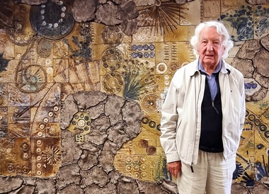
Photograph, Lucie Akers, John Gilbert in front of Enigmatic Land by Lucie Akers, 2024, 2024
... University Australia E.J. Barker Library (top floor) Mount Helen goldfields John Gilbert ceramics John Gilbert stands in front of Enigmatic Land, a ceramic mural commissioned in 1973 for the entrance of the Mt Helen Campus Library John Gilbert in front of Enigmatic Land by Lucie Akers, 2024 Photograph Lucie Akers ...John Gilbert stands in front of Enigmatic Land, a ceramic mural commissioned in 1973 for the entrance of the Mt Helen Campus Libraryjohn gilbert, ceramics -
Federation University Historical Collection
Book - Book - Scrapbook, Ballarat University College: Newspaper Cuttings, January to December 1991 and January to December 1992
... university of the third age...protests to government...dick de fegely...buc...land...University of the Third Age plan for coming year. Protests over the Government's remarks over Ag Department move. Caution urged by MLC Dick de Fegely. Land...University of the Third Age plan for coming year. Protests over the Government's remarks over Ag Department move. Caution urged by MLC Dick de Fegely. Land ...Newspaper cuttings collected from various sources. - Ballarat Courier, The Australian, Warrnambool Standard, The Age, The Standard, The News, Ballarat News, East Gippsland News. The items are from 26 January to 20 December 1991 and 11 January to 12 December 1992. Institutions in rush to beat merger date - Victoria's education dilemma. University of the Third Age plan for coming year. Protests over the Government's remarks over Ag Department move. Caution urged by MLC Dick de Fegely. Land rehabilitation program centre at BUC. New university must not be thwarted. $24000 grant provided for specialist lectures. Tertiary education faces crisis as student numbers boom. Lack of student accommodation means some students are living in local hotels. BUC and Melbourne Uni given $500000 grant. It will be used to develop a Masters in Engineering Science (Hydrogeology) course, the first of its kind in Victoria. BUC has opened the F M Krause Broken Hill Mineral collection. Students bring weekend of music to BUC. Nicky Taws and Rob Plowright to represent Australia in the World Orienteering Championships. White A4 two ring folder. Divided into months by coloured dividers. Folder has black marks from previous use.ballarat university college, australia day honor to jack barker, institutions and merger date, university of the third age, protests to government, dick de fegely, buc, land rehabilitation, rmit and merger, student accommodation shortage, masters in engineering science, hydrogeology, krause collection on show, music at buc, nicky taws, rob plowright, orienteering championships, australian women's cricket, development squad camp at buc -
 Federation University Historical Collection
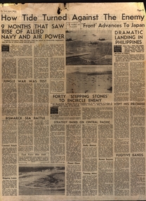
Newspaper, Jungle War and Bismark Sea Battle, 1945, 1945
... University Australia E.J. Barker Library (top floor) Mount Helen goldfields World War 2 Japanese Jungle War Bismark Sea Battle US Fleet Phillipines Burma Munition workers Land Army ration books Jungle War and Bismark Sea Battle, 1945 Newspaper ...world war 2, japanese, jungle war, bismark sea battle, us fleet, phillipines, burma, munition workers, land army, ration books -
Federation University Historical Collection
Letter, Inwards Correspondence to the Ballarat School of Mines, 1898, 1898
... University Australia E.J. Barker Library (top floor) Mount Helen goldfields thomas Harwood Darwin mining Letterhead Ivor Davis frogmore Sorell tasmania D.W. Kennedy jAmes Horsfall Walter Andrews thomas P. Lewis J.H. Salter lettercard Queenstown Tasmania Arch Douglas Thomas Andrews Gundagai Joseph Bryant C.M. Bryant Percy Glenton Clunes Land ...A number of handwritten letters bound together with a brass split pin on the top right corner. * Letter from Thomas Harwood from Port Darwin concerning bags of auriferous sand for treatment. * Letterhead from Ivor Davies, Cambrian Battery, Mosquito Flat * Request for results and certificates from D.W. Kennedy * J.H. Salter requesting a Ballarat School of Mines prospectus * Ballarat School of Mines Indentures student Thonmas Andrews * Letter introducing prospective student Walter Pomeroy * Ballarat School of Mines visit to New Normanby Mine * Letter from Sara McLean of Daylesfors asking about Botany, Geology and Drawing classes and railway forms. thomas harwood, darwin, mining, letterhead, ivor davis, frogmore sorell tasmania, d.w. kennedy, james horsfall, walter andrews, thomas p. lewis, j.h. salter, lettercard, queenstown tasmania, arch douglas, thomas andrews, gundagai, joseph bryant, c.m. bryant, percy glenton, clunes, land surveying, chalk and cahir, steam gauge testing, brisbane newspaper company, h. herman, t. price, geelong college letterhead, walter pomeroy, industrial schools act, n.r salmon, james and mccrindle, homes mccrindle, broken hill, j.e. blake, norval, john pearce, new nprmanby mine, maryborough school of mines, duncan mcdougall, old scotch collegians club, w.a. gosman, broken hill pty co. ltd, w. robertson, howard smith and sons, sara mclean, daylesford, william h. nicholas, surprise gold mining company, a. vaudeau, j.w. banfield, letterhead*, william howard smith and sons, port pirrie, blakeville, royal mint, assay -
 Federation University Historical Collection
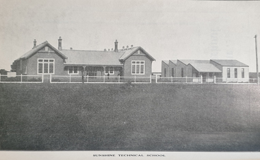
Booklet - Booklet - Prospectus, Exchange Press Pty Ltd, Sunshine Technical School, Prospectus, 1914, 1914
... University Australia E.J. Barker Library (top floor) Mount Helen goldfields Used at School of mines and industries Ballarat As H.V. McKay's Sunshine Harvester business expanded there was a requirement for a school to train the company's apprentices. In 1911, H.V. McKay wrote to the Victoria Cabinet offering 2,000 pounds and 4 1/2 acres of land ...Used at School of mines and industries Ballarat As H.V. McKay's Sunshine Harvester business expanded there was a requirement for a school to train the company's apprentices. In 1911, H.V. McKay wrote to the Victoria Cabinet offering 2,000 pounds and 4 1/2 acres of land in Derby Rd for a technical school, On the 7th July 1913, the new Sunshine Technical School opened with a wooded administration building with six class rooms and a large galvanised iron workshop for the trade apprentices. Mr George Baxter was appointed principal with assistant teachers, A.J. Dunlop (Maths & English), W.W. Anderson (Art) & H.B. Ernest (Maths & Science). Seventy students were enrolled in the first year of which 44 were apprentices from the Harvester Works. During the First World War Years (1914 - 1918) there was a difficulties with staffing and enrollments. The school was also used to provide vocational training for wounded returned soldiers. In 1919 during the great influenza epidemic the school was used as a hospital. Light blue soft covered booklet of 60 pages with information about office bearers, staff, objects of the school, prizes and scholarships, examinations, time tables, courses, and subjects. It has photographs and advertising.sunshine, technical school, sunshine technical school, prospectus, hugh victor mckay, r.m. lambert, george mckay, d.b. ferguson, samuel mckay, george bult, ralph mckay, george butlin, george baxter, f.s. midgley, j.b. gray, w. kerr, a.j. dunlop, h. ernst, w.w. anderson, f. cleary, school councillors, staff, blacksmithing, carpentry, fitting and turning, moulding, sheet metal, mathematis, english, science, art, 1914, h v mckay, sunshine harvester, 2000 pounds and land donated, wounded returned soldiers, 1919 ued as hospital, influenza epidemic