Showing 102 items matching "unsealed road"
-
 Eltham District Historical Society Inc
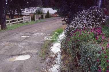
Photograph - Colour Print, Potholes in unidentified unsealed road, near Eltham, c.1990
... Potholes in unidentified unsealed road, near Eltham...Eltham houses Infrastructure Potholes streets Streetscape Kodak 5005 EPP Roll of 35mm colour positive film, 2 separated frames Potholes in unidentified unsealed road, near Eltham Photograph Colour Print ...Other frame was view of similar road conditions at Haldane and Metery Roads, Eltham. Council officers reviewing road surface breakdown due to weather conditions and road traffic causing potholes and dips.Roll of 35mm colour positive film, 2 separated framesKodak 5005 EPPeltham, houses, infrastructure, potholes, streets, streetscape -
 Lakes Entrance Historical Society
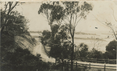
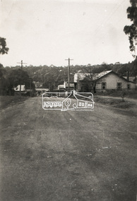
Postcard - Princes Highway around Jemmy's Point
... Princes Highway around Jemmy's Point . Unsealed road and post and rail fence. Bullock Island and the entrance in the distance c1925...Black and white photograph of Princes Highway around Jemmy's Point . Unsealed road and post and rail fence. Bullock Island and the entrance in the distance...Unsealed road and post and rail fence. Bullock Island and the entrance in the distance Princes Highway around Jemmy's Point Postcard Princes Highway around Jemmy's Point ...Princes Highway around Jemmy's Point . Unsealed road and post and rail fence. Bullock Island and the entrance in the distance c1925Black and white photograph of Princes Highway around Jemmy's Point . Unsealed road and post and rail fence. Bullock Island and the entrance in the distance waterways, topography, islands, roads and streets -
 City of Kingston
Photograph - Black and white, c. 1958
... Unsealed roads and drainage problems created difficulties for those living in Beaumaris during the 1950s...Black and white image depicting the Balcombe Road and Haywood Street, Beaumaris. Unsealed roads and drainage problems have created boggy slushy land. ...Unsealed roads and drainage problems have created boggy slushy land. ...Unsealed roads and drainage problems created difficulties for those living in Beaumaris during the 1950sBlack and white image depicting the Balcombe Road and Haywood Street, Beaumaris. Unsealed roads and drainage problems have created boggy slushy land. There are houses in the background, indicating people live in the area.Handwritten in red ink on reverse: 90% Handwritten in blue ink on reverse: 2193beaumaris, roads, drainage, water logged, housing -
 City of Kingston
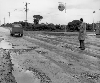
Photograph - Black and white, c. 1950
... This image depicts the unsealed roads with potholes prevalent in the quickly developing suburbs of Black Rock and Beaumaris. ...He is watching a utility vehicle with registration GFM033 as it drives on the unsealed road through mud and potholes....City of Kingston Parkdale Library 96 Parkers Road, Parkdale Parkdale This image depicts the unsealed roads with potholes prevalent in the quickly developing suburbs of Black Rock and Beaumaris. ...This image depicts the unsealed roads with potholes prevalent in the quickly developing suburbs of Black Rock and Beaumaris. In the post war era, as the suburbs of Beaumaris and Black Rock grew, the infrastructure for roads was falling behind. The unsealed roads were dusty in summer and muddy with potholes in winter. Drainage was poor and roads difficult to navigate.Black and white photograph of a man standing outside the Shell service station in Balcombe Road, possibly at Beaumaris. He is watching a utility vehicle with registration GFM033 as it drives on the unsealed road through mud and potholes.Handwritten in blue ink: 2195 Handwritten in red ink: 80%roads, infrastructure, beaumaris, black rock, balcombe road -
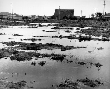
 City of Kingston
Photograph - Black and white, c. 1958
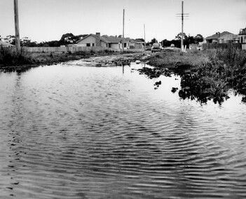
... Gutters and road surfaces were made of clay and in the wetter months of winter, unsealed roads and tracks became impossible quagmires that were unnavigable for vehicles and pedestrians. ...The image shows floodwaters with boggy and rough terrain on an unsealed road with housing in the distance....The image shows floodwaters with boggy and rough terrain on an unsealed road with housing in the distance. Photograph Black and white ...This photograph depicts flooding of Ozone Avenue in Beaumaris, located off Balcombe Road. Roads in the Beaumaris area lacked sufficient drains to clear surface water. In many cases streets were unsealed and without footpaths and some were dirt tracks. Gutters and road surfaces were made of clay and in the wetter months of winter, unsealed roads and tracks became impossible quagmires that were unnavigable for vehicles and pedestrians. In the first decade after World War II there was rapid expansion in construction of new houses in the suburb of Beaumaris. Utilities and infrastructure to support the growth of housing was inadequate and not provided for prior to the development of the area. Without rudimentary drainage, flooding was frequent. Storm water runoff, domestic sullage and septic tank overflow would form large pools and families were sometimes marooned within their homes. The frequent flooding caused isolation and hardship and residents endured difficulties with accessibility to facilities. These disadvantages had the potential to cause social issues for the new residents.Black and white photograph of flooding in Ozone Avenue, Beaumaris. The image shows floodwaters with boggy and rough terrain on an unsealed road with housing in the distance.Handwritten in blue ink: 2124 circled Handwritten in red ink: 80% Handwritten in blue ink on yellow Post-It note: Chap 6. underlined, 2194 Ozone Ave Beaumaris 1958beaumaris, ozone avenue, balcombe road, flooding, roads, infrastructure -
 Eltham District Historical Society Inc
Negative - Photograph, Unidentified rural property, Eltham district, c.1985
... ...Unsealed road...Eltham District Historical Society Inc 728 Main Rd Eltham melbourne Driveway Infrastructure Residential Rural property Unsealed road Kodak CL200 5093 Roll of 35mm colour negative film, 1 strip, 3 frames Unidentified rural property, Eltham district Negative Photograph ...Roll of 35mm colour negative film, 1 strip, 3 framesKodak CL200 5093driveway, infrastructure, residential, rural property, unsealed road -
 Victoria Police Museum
Photograph (police car), Kodak
... Daimler (registration number 931) on unsealed road. Circa 1926...Used as transport for the Chief Commissioner after having been badly damaged in an accident in Brighton in 1931. police vehicles; transport; motor police branch; daimler car; wireless patrol Daimler (registration number 931) on unsealed road. Circa 1926 Photograph (police car) Kodak ...Daimler 35HP sedan. Used as transport for the Chief Commissioner after having been badly damaged in an accident in Brighton in 1931.Daimler (registration number 931) on unsealed road. Circa 1926police vehicles; transport; motor police branch; daimler car; wireless patrol -
 Halls Gap & Grampians Historical Society
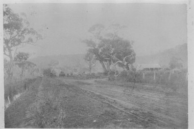
Photograph - B/W, C 1920s
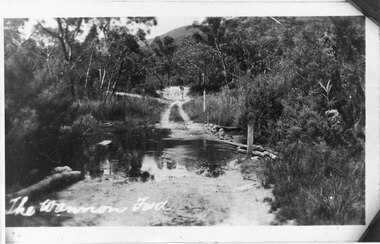
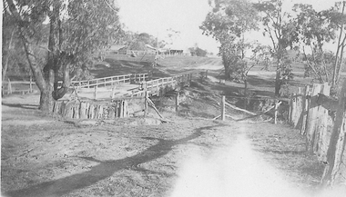
... Photo shows a rough, unsealed road running through a ford (the Wannon Ford)....ACCESS ROUTES Roads Photo shows a rough, unsealed road running through a ford (the Wannon Ford). ...The Wannon Ford - typical of creek crossings in the Grampians.Photo shows a rough, unsealed road running through a ford (the Wannon Ford).access routes, roads -
 Orbost & District Historical Society
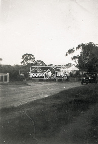
black and white photographs, C 1970s
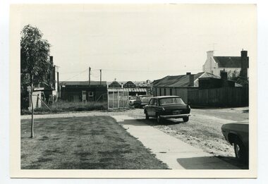
... Two black / white photographs showing cars parked on an unsealed road with buildings in the background....Lawson-Lane-Orbost streets-Orbost-1970s Two black / white photographs showing cars parked on an unsealed road with buildings in the background. black and white photographs ...3288.1 has been taken in Lawson Lane, Orbost, looking west from the rear of the Shire Offices. 3288.2 has been taken in Lawson Lane, Orbost, looking east from the rear of the Shire Offices.These photographs are pictorial records of the Orbost township C 1970s.Two black / white photographs showing cars parked on an unsealed road with buildings in the background.lawson-lane-orbost streets-orbost-1970s -
 Orbost & District Historical Society
black and white photograph, 1920 - 1930
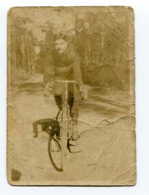
... A small black / white photograph of a young man on a racing bike. It is on an unsealed road in a forest. ...Donchi, Cyclist, Orbost" A small black / white photograph of a young man on a racing bike. It is on an unsealed road in a forest. black and white photograph ...By 1905 there was an Orbost Bicycle Club. E. Donchi was a member and was a successful competitor around 1927. It is likely that the Orbost Cycling Club disbanded during WWI, and evidence from the Snowy River Mail is that it reformed again in 1945. There is no doubt that bikes were a dominant form of personal transport until the 1960s when cars ownership became more common, although children still rode to school. As far as theOrbost Cycling Club was concerned, the golden years were from 1945 to 1950. (information Newsletter August 2018 - Geoff & Lee Stevenson)This item is associated with a popular recreational activity in early Orbost. The period between the First World War and the 1950s was the heyday of cycling. After 1900 the efficient mass production of standardized safe bicycles, as well as the wider availability of second-hand bicycles, caused rapidly dropping prices and it was therefore easier for people to purchase a bicycle not only for utilitarian use but for racing. A small black / white photograph of a young man on a racing bike. It is on an unsealed road in a forest. on back - "E. Donchi, Cyclist, Orbost"donchi cycling-orbost recreation -
 City of Kingston
Photograph - Black and white
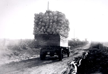
... A truck, fully loaded with cauliflower travelling along McKinnon Road towards Tucker Road. The road is unsealed and recent rains have left large puddles along the sides. ...Black and white image of a truck fully loaded with cauliflowers travelling along an unsealed boggy road, to market....road. Vegetables Cauliflower Market Truck Transport Black ink printed on a white circular sticker: 32 Handwritten in red ink: 70% Black and white image of a truck fully loaded with cauliflowers travelling along an unsealed boggy road, to market. ...A truck, fully loaded with cauliflower travelling along McKinnon Road towards Tucker Road. The road is unsealed and recent rains have left large puddles along the sides. Open paddocks appear on either side of the road.Black and white image of a truck fully loaded with cauliflowers travelling along an unsealed boggy road, to market.Black ink printed on a white circular sticker: 32 Handwritten in red ink: 70%vegetables, cauliflower, market, truck, transport -
 Glenelg Shire Council Cultural Collection
Photograph - Photograph - Road and bridge, n.d
... Coloured photograph. Unsealed road between two paddocks. Wooden bridge and railings. ...Glenelg Shire Council Cultural Collection History House Cliff Street Portland great-ocean-road Sourced from Casterton Town Hall (former Shire of Glenelg) Coloured photograph. Unsealed road between two paddocks. Wooden bridge and railings. ...Sourced from Casterton Town Hall (former Shire of Glenelg)Coloured photograph. Unsealed road between two paddocks. Wooden bridge and railings. Sign at bridge ' Bridge Load Limit 5t gross' -
 El Dorado Museum Association Inc.
Photograph - Digital Image
... Digital image copied from a black and white photograph of a bridge over a creek joining an unsealed road leading to a house on a rise overlooking the bridge....El Dorado Museum Association Inc. 136 Main Street El Dorado high-country Mulls Bridge, from Daddy Simpsons Album. bridge creek el dorado eldorado Digital image copied from a black and white photograph of a bridge over a creek joining an unsealed road leading to a house on a rise overlooking the bridge. ...Mulls Bridge, from Daddy Simpsons Album.Digital image copied from a black and white photograph of a bridge over a creek joining an unsealed road leading to a house on a rise overlooking the bridge.bridge, creek, el dorado, eldorado -
 Halls Gap & Grampians Historical Society
Photograph - B/W, C 1929 - 34
... Photo shows a house with a smaller building to the right (Knight's tea-rooms at the Wannon).There is a car parked in front of the house and an unsealed road runs through the foreground....BUILDINGS Tea Rooms Photo shows a house with a smaller building to the right (Knight's tea-rooms at the Wannon).There is a car parked in front of the house and an unsealed road runs through the foreground. Photograph B/W ...The Knight's Tea-Rooms, which were known as "Coonarah". See "Victoria's Wonderland" p. 103-104 for further information.Photo shows a house with a smaller building to the right (Knight's tea-rooms at the Wannon).There is a car parked in front of the house and an unsealed road runs through the foreground.buildings, tea rooms -
 Mission to Seafarers Victoria
Photograph - Photograph, Sepia, View of Piers, Port Melbourne from Mission windows, Early 20th C
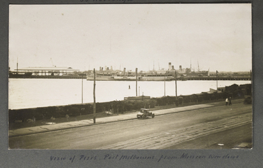
... Small Landscape B and W image of ships moored alongside a pier in distance and small early car in foreground on unsealed road travelling left to right. ...Small Landscape B and W image of ships moored alongside a pier in distance and small early car in foreground on unsealed road travelling left to right. View of Piers, Port Melbourne from Mission windows Photograph Photograph, Sepia ...This image appears to have been taken from the second storey of the Mission to Seamen, on Beach Rd Esplanade, Port Melbourne circa 1912 - 1920. One of several images on loose album pages.An early image taken from the building established in Port Melbourne initially in the mid 19th C and operating up to the 1930s until replaced by a modern deco building in 1936. Shows examples of vintage cars.Small Landscape B and W image of ships moored alongside a pier in distance and small early car in foreground on unsealed road travelling left to right. Handwritten descriptive inscription is written underneath on an album page.port melbourne, mission to seamen building, port melbourne pier, fan album -
Tatura Irrigation & Wartime Camps Museum
Artwork, other - Painting oil, Victorian Summer Landscape
... Rectangular wooden frame - oil painting on wooden board - scene depicting blue river, trees, shrubbery and unsealed road in the foreground and a yellow hill in the background...Rectangular wooden frame - oil painting on wooden board - scene depicting blue river, trees, shrubbery and unsealed road in the foreground and a yellow hill in the background Victorian Summer Landscape Artwork, other Painting oil Charlotte Rippert ...This artwork was painted by Charlotte Rippert who was interned in Camp 3 with her whole family. The painting was painted in camp. Charlotte Rippert was a German Lutheran Missionary in Egypt, arrested as a security risk in Cairo, 1941. Transported on Queen Elizabeth to Australia and interned at Camp 3 1941-1945.Rectangular wooden frame - oil painting on wooden board - scene depicting blue river, trees, shrubbery and unsealed road in the foreground and a yellow hill in the backgroundTag attached - reads "Victorian Summer Landscape by Frau Rippert in Camp 3. Donors: Glockemann Family."landscape -
Glenelg Shire Council Cultural Collection
Postcard - Postcard - Lighthouse and harbour Portland Victoria, n.d
... Postcard, Lighthouse & Harbour, Portland, Victoria, from the "Rose" series ----colourview No 503, showing adult & three children walking on an unsealed road north of Whaler's Bluff....Glenelg Shire Council Cultural Collection History House Cliff Street Portland great-ocean-road Postcard, Lighthouse & Harbour, Portland, Victoria, from the "Rose" series ----colourview No 503, showing adult & three children walking on an unsealed road north of Whaler's Bluff. Postcard Postcard - Lighthouse and harbour Portland Victoria ...Postcard, Lighthouse & Harbour, Portland, Victoria, from the "Rose" series ----colourview No 503, showing adult & three children walking on an unsealed road north of Whaler's Bluff. -
Glenelg Shire Council Cultural Collection
Photograph, 1950-1960
... One on left is part of unsealed road, the one on right is a wooden bridge. ...One on left is part of unsealed road, the one on right is a wooden bridge. ...Sourced from Casterton Town Hall former Shire of GlenelgBlack and white photo. Two bridges, side by side. One on left is part of unsealed road, the one on right is a wooden bridge. Kings Bridge Merino-Coleraine Rd.Front: 'Kings Bridge Merino-Coleraine Rd. Traffic detoured over temporary Bridge on Right' - handwritten, pen Back: Photographer's stamp - round, purple -
 City of Kingston
Photograph - Black and white, Percy Fairlam, c. 1910
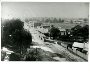
... Black and white image depicting aerial view down Charman Road, Cheltenham, including the unsealed road, level crossing and shopping centre. ...Cheltenham Railway crossing Roads Housing Shopping strip Handwritten in black ink on a red round sticker adhered to the reverse, and then crossed out: X14 Handwritten in blue ink on reverse: A8 Handwritten in red ink on reverse: 85% Black and white image depicting aerial view down Charman Road, Cheltenham, including the unsealed road, level crossing and shopping centre. ...Black and white image of Cheltenham in the early 20th Century depicts an almost idyllic life. This photo was taken by Percy Fairlam, who climbed a tall pine tree to achieve the aerial view. The tree was a well recognised feature of the Cheltenham skyline but was cut down some time before World War II.Cheltenham was established as a rural market gardening community. The development of the railway was crucial to the ongoing development of the area. Community life sprung up around the railway line which is evident in the proximity of shopping and leisure.Black and white image depicting aerial view down Charman Road, Cheltenham, including the unsealed road, level crossing and shopping centre. What appears to be a cricket pitch is located behind the shops.Handwritten in black ink on a red round sticker adhered to the reverse, and then crossed out: X14 Handwritten in blue ink on reverse: A8 Handwritten in red ink on reverse: 85%cheltenham, railway crossing, roads, housing, shopping strip -
 Canterbury History Group
Photograph - J. Weymouth , Ironmonger, c1910
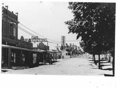
... Weymouth Ironmonger, north side of Canterbury Road. Unsealed road and gutters, horse and cart in front of shop and closed railway gates...Weymouth Ironmonger, north side of Canterbury Road. Unsealed road and gutters, horse and cart in front of shop and closed railway gates Canterbury Canterbury Road Railway Crossings Horse Drawn Vehicles J. ...J. Weymouth Ironmonger, north side of Canterbury Road. Unsealed road and gutters, horse and cart in front of shop and closed railway gatesBlack and white photographcanterbury, canterbury road, railway crossings, horse drawn vehicles, j. weymouth> ironmonger -
Lakes Entrance Historical Society
Map - Grant Historic Adventurer, Paolett Adventure Maps, March 1998
... Shows sealed and unsealed roads, rivers or creeks. McMillans walking track, picnic areas, camping areas, Alpine National Park 1 page Included with map is a flyer for township of Grant compiled by Friends of Grant 10517A...Lakes Entrance Historical Society 4 Marine Parade Lakes Entrance gippsland forest recreation Townships Roads and Streets parks Shows sealed and unsealed roads, rivers or creeks. McMillans walking track, picnic areas, camping areas, Alpine National Park 1 page Included with map is a flyer for township of Grant compiled by Friends of Grant 10517A Map Grant Historic Adventurer Paolett Adventure Maps ...Shows sealed and unsealed roads, rivers or creeks. McMillans walking track, picnic areas, camping areas, Alpine National Park 1 page Included with map is a flyer for township of Grant compiled by Friends of Grant 10517Aforest, recreation, townships, roads and streets, parks -
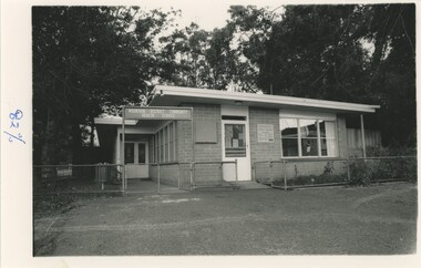 Emerald Museum & Nobelius Heritage Park
Photograph - Mountain District Community Health Service and Cockatoo Instant Welfare Centre 1960s, c. 1964
... The building is enclosed by a low metal fence and two open gates, and sits on an unsealed road. Behind the building are a number of tall trees. ...The building is enclosed by a low metal fence and two open gates, and sits on an unsealed road. Behind the building are a number of tall trees. ...The Mountain District Community Health Service (MDCHS) was conceived of by Cockatoo local Myrtle Quicke, a well-renowned medical professional and nurse in the early-mid 1900s, as well as a founder of the Australian College of Nursing. After moving to Cockatoo in 1954, she quickly realised the shortage of adequate medical care in the area and organised the establishment of the MDCHS. This involved fundraisers and meetings with both locals and council officials to drum up funding and support against opposition who believed there was no need for such a centre. For many years, money was raised for the MDCHS by an opportunity shop nearby until the centre opened on the 3rd of March, 1964. It operated on a membership service, costing £1/5 a year for a single man or woman with no dependents, and a nurse was in attendance 24-hours a day. Alongside the development of the MDCHS, the Berwick Shire council (now part of Cardinia Shire) decided to assign an Infant Welfare Nurse to Cockatoo in order to assist with an influx of new babies in the area. An Infant Welfare Centre was attached to the MDCHS, and opened at the same time. Myrtle joked that she would have the Queen open the building, but it was instead opened by the Governor of Victoria, Sir Rohan Delacombe. The day was one of great celebration for all in the town.This photograph documents the growth of local healthcare and medicine, as well as one of the many accomplishments of Myrtle Quicke.A black and white photograph of the front of a brick building. The building is enclosed by a low metal fence and two open gates, and sits on an unsealed road. Behind the building are a number of tall trees. On the reverse of the photograph is a handwritten pencil caption.In photograph, on freestanding sign: "MOUNTAIN DISTRICT COMMUNITY / HEALTH SERVICE" In photograph, on sign on brick wall: "COCKATOO / INFANT WELFARE / CENTRE" Reverse, handwritten in pencil: "'MOUNTAIN DISTRICT COMMUNITY / HEALTH SERVICE' / AND / 'COCKATOO INFANT WELFARE CENTRE 1960's'"cockatoo, 1960s, medical & health -
Glenelg Shire Council Cultural Collection
Postcard - Postcard - Portland Lighthouse, c. 1950
... Postcard showing lighthouse & Harbour, Portland, Victoria, from the "Rose" series ----colourview No 503, showing adult & three children walking on an unsealed road north of Whaler's Bluff. Clothing suggests c. 1950's-60's...Glenelg Shire Council Cultural Collection History House Cliff Street Portland great-ocean-road postcard view of Portland holiday Whalers Bluff lighthouse Postcard showing lighthouse & Harbour, Portland, Victoria, from the "Rose" series ----colourview No 503, showing adult & three children walking on an unsealed road north of Whaler's Bluff. Clothing suggests c. 1950's-60's Postcard Postcard - Portland Lighthouse ...Postcard showing lighthouse & Harbour, Portland, Victoria, from the "Rose" series ----colourview No 503, showing adult & three children walking on an unsealed road north of Whaler's Bluff. Clothing suggests c. 1950's-60'spostcard, view of portland, holiday, whalers bluff, lighthouse -
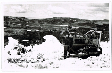 Kiewa Valley Historical Society
Postcard Circa 1950, Snow Plough, Bogong High Plain,5,500 Feet Kiewa Hydro-Electric Project, Circa 1950
... This item is a black and white photograph(professional) of a panoramic view of a snow plough clearing the unsealed road in 1950.This postcard is on quality paper and the reproduction of the picture is of a high standard.For other "tourist" postcards see 0480 (A) -(F) for other photos of similar postcards. ...This postcard was purchased in 1950 by a surveyor at Landford's Gap. kiewa valley tourism victorian alps alternate energy supplies alpine population growth SECV snow plough This item is a black and white photograph(professional) of a panoramic view of a snow plough clearing the unsealed road in 1950.This postcard is on quality paper and the reproduction of the picture is of a high standard.For other "tourist" postcards see 0480 (A) -(F) for other photos of similar postcards. ...This postcard was produced in the 1950's for the tourist trade in the Kiewa Valley and Alpine region. It encompasses the period when the State of Victoria was pressured by the ever increasing demand by industry and its population for electricity supplies. Hydro electricity was seen as an untapped natural resource to quench this demand. The Victorian Alps and the rivers flowing into its valleys was ideal for the construction of the Kiewa Hydro Electricity Scheme. The late 1940's saw the development of this scheme and the changing of sections of alpine landscape is covered by this and other postcards/pictures (tourists, construction workers, and established rural populations). This period in time was before the established wildlife and forest/nature groups became political activist who changed legislative acts to protect the environment. This rural region (Kiewa Valley/alpine plains) was at most only significant to a smaller group of winter sports, summer hikers/horse riders and rural farmers/graziers. The numbers of tourists and the increase in the local resident population was boosted by the construction of the Hydro Electricity Scheme. This influx to the regional population resulted in a corresponding diversity in services and brought about an environment that responded to a growing level of tourists and thereby permitting this industry to grow more rapidly than it would have naturally. This postcard details an attraction to the "cleaner" method of providing electricity. This postcard was purchased in 1950 by a surveyor at Landford's Gap. This item is a black and white photograph(professional) of a panoramic view of a snow plough clearing the unsealed road in 1950.This postcard is on quality paper and the reproduction of the picture is of a high standard.For other "tourist" postcards see 0480 (A) -(F) for other photos of similar postcards. kiewa valley tourism, victorian alps, alternate energy supplies, alpine population growth, secv, snow plough -
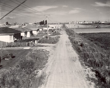 City of Kingston
Photograph - Black and white, c. 1960
... Road in the distance. The gardens and new homes are well-tended, but the street surfacing is unsealed....Black and white photograph of unsealed road in new development in the area of Moorabbin, new houses appear on the lefthand side with paddocks on right side of image with installation of electric poles. ...Bentleigh East Bentleigh Market Garden Housing Suburbs Infrastructure Moorabbin Handwritten in blue ink: 60 - 373 D Handwritten in red ink: 80% Handwritten in black ink: Ch. 6 Black and white photograph of unsealed road in new development in the area of Moorabbin, new houses appear on the lefthand side with paddocks on right side of image with installation of electric poles. ...This image depicts a scene of East Bentleigh in 1960, viewed along Thomasina Street as it crosses Gladwyn Street towards East Boundary Road in the distance. The gardens and new homes are well-tended, but the street surfacing is unsealed.Developing urban area now located within the City of Glen Eira, formally City of Moorabbin. This image illustrates the mid century urban sprawl of new suburbs and the subdivision of market gardens within the municipality and the changing demographic of the district as new houses are constructed and infrastructure established. Black and white photograph of unsealed road in new development in the area of Moorabbin, new houses appear on the lefthand side with paddocks on right side of image with installation of electric poles. Sealed road in the distance. Thomasina Street, as it crosses Gladwyn Street, East Bentleigh towards East Boundary Road. Handwritten in blue ink: 60 - 373 D Handwritten in red ink: 80% Handwritten in black ink: Ch. 6bentleigh, east bentleigh, market garden, housing, suburbs, infrastructure, moorabbin -
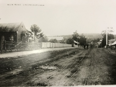 Greensborough Historical Society
Photograph, Main Road Greensborough c1900, 1900c
... Tracks of buggy wheels on unsealed road....Tracks of buggy wheels on unsealed road. A collection of 5 enlargements of sites in Greensborough township in the early 1900s. main street greensborough methodist church greensborough rechabite hall Black and white enlargement of photographic image Main Road Greensborough c1900 Photograph ...Main Road (later re-named Main Street) Greensborough c1900. Note Methodist Church on left, site of present entrance to the shopping complex. Also shows the Rechabite Hall further down on the left side. Tracks of buggy wheels on unsealed road.A collection of 5 enlargements of sites in Greensborough township in the early 1900s.Black and white enlargement of photographic imagemain street greensborough, methodist church greensborough, rechabite hall -
 Eltham District Historical Society Inc
Photograph, Looking towards the Railway Station, Were Street, Montmorency, c.1940, 1940c
... Other photos of Were St featuring the Dandy family dated 8 October 1950 show an unsealed road with concrete kerb and channeling. ...Eltham District Historical Society Inc 728 Main Rd Eltham melbourne Other photos of Were St featuring the Dandy family dated 8 October 1950 show an unsealed road with concrete kerb and channeling. ...Other photos of Were St featuring the Dandy family dated 8 October 1950 show an unsealed road with concrete kerb and channeling. The surrounds look very similar but no concrete kerb and trees in footpath significantly younger and smaller in size; hence c.1940Roll of 35mm black and white negative film, sectioned into frames; copy of print photograph Ilford FP-4montmorency, railway station, were street -
 Eltham District Historical Society Inc
Photograph, Looking south on Were Street towards Rattray Road, Montmorency, c.1940, 1940c
... Other photos of Were St featuring the Dandy family dated 8 October 1950 show an unsealed road with concrete kerb and channeling. ...Eltham District Historical Society Inc 728 Main Rd Eltham melbourne Other photos of Were St featuring the Dandy family dated 8 October 1950 show an unsealed road with concrete kerb and channeling. ...Other photos of Were St featuring the Dandy family dated 8 October 1950 show an unsealed road with concrete kerb and channeling. The surrounds look very similar but no concrete kerb and trees in footpath significantly younger and smaller in size; hence c.1940Roll of 35mm black and white negative film, sectioned into frames; copy of print photograph Ilford FP-4montmorency, railway station, were street -
 Halls Gap & Grampians Historical Society
Photograph - B/W
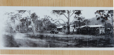
... The photo appears to have been taken on a foggy day. It shows an unsealed road flanked by a few gum trees and with a ditch containing water on the left. ...BUILDINGS Houses The photo appears to have been taken on a foggy day. It shows an unsealed road flanked by a few gum trees and with a ditch containing water on the left. ...This is a photo of Mason's house, on the road to Ladysmith in the Mt William gold fields.The photo appears to have been taken on a foggy day. It shows an unsealed road flanked by a few gum trees and with a ditch containing water on the left. On the right in the middle distance there is a house with a twin pitched roof and a veranda at the front. In the distance on the road is a vehicle and what appears to be a few people. The are mountains in the far background.buildings, houses -
 Lakes Entrance Historical Society
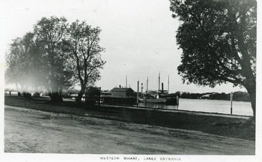
Photograph - Western Wharf, colloquially known as the Post Office Jetty. Lakes Entrance Victoria, 1910c
... Some banksia trees on bank, also small tree inside tree guard. Unsealed road in foreground. Lakes Entrance Victoria...Some banksia trees on bank, also small tree inside tree guard. Unsealed road in foreground. Lakes Entrance Victoria Photograph Western Wharf, colloquially known as the Post Office Jetty. ...Black and white photograph of the Western Wharf, colloquially known as the Post Office Jetty. It shows a steamer moored at the wharf beside a sail powered vessel. There is a shed at the end of the jetty, another near the shore. Some banksia trees on bank, also small tree inside tree guard. Unsealed road in foreground. Lakes Entrance VictoriaWestern Wharf Lakes Entrancejetties, township, ships and shipping