Showing 330 items matching "valley lake"
-
 Federation University Historical Collection
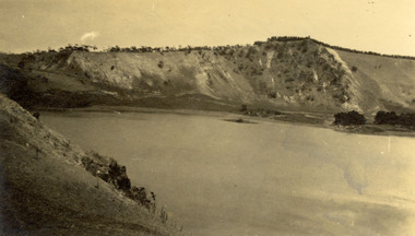
Photograph - Photograph - black and white, Mt Gambier
... ...valley Lake...Verso: 'The Valley Lake Mt. Gambier...Barker Library (top floor) Mount Helen goldfields Chatham family Archive Chatham Mt Gambier Blue Lake valley Lake Verso: 'The Valley Lake Mt. Gambier Blaclk and white photographic postcard showing a lake and mountains and Mt Gambier, South Australia. ...Blaclk and white photographic postcard showing a lake and mountains and Mt Gambier, South Australia.Verso: 'The Valley Lake Mt. Gambierchatham family archive, chatham, mt gambier, blue lake, valley lake -
 Stawell Historical Society Inc
Slide, Ian McCann, Looking Up the Valley toward Lake Bellfield, 1960's
... Looking Up the Valley toward Lake Bellfield...Looking up the Valley toward Lake Bellfield under construction....Looking up the Valley toward Lake Bellfield under construction. Looking Up the Valley toward Lake Bellfield Slide Ian McCann ...Clolour slide. Looking up the Valley toward Lake Bellfield under construction.grampians -
 Rutherglen Historical Society
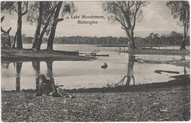
Postcard, Lake Moodemere, Rutherglen, 1900-1908
... ...kiewa valley...lake...Lake Moodemere. Neddy spent the latter part of his life here, especially after his Wife Charlotte and children Thomas, Harry, Dolly and Kate were taken from him in the Kiewa Valley and taken to Lake Tyers.The Aboriginal Protection Board would provide travel passes for him to visit his Country. ...He died in April 1908 lake moodemere neddy wheeler dhudhuroa charlotte wheeler thomas wheeler harry wheeler dolly wheeler kate wheeler kiewa valley lake tyres aboriginal protection board Printed at top of photo: "Lake Moodemere, Rutherglen" Black and white photograph, printed on postcard, showing view of Lake Moodemere, with a man wearing a jacket and hat, reclining on the bank in the foreground. ...This photo is of Neddy Wheeler - Dhudhuroa man and language informant to RH Matthews. The photo was taken at Lake Moodemere. Neddy spent the latter part of his life here, especially after his Wife Charlotte and children Thomas, Harry, Dolly and Kate were taken from him in the Kiewa Valley and taken to Lake Tyers.The Aboriginal Protection Board would provide travel passes for him to visit his Country. He died in April 1908Black and white photograph, printed on postcard, showing view of Lake Moodemere, with a man wearing a jacket and hat, reclining on the bank in the foreground.Printed at top of photo: "Lake Moodemere, Rutherglen"lake moodemere, neddy wheeler, dhudhuroa, charlotte wheeler, thomas wheeler, harry wheeler, dolly wheeler, kate wheeler, kiewa valley, lake tyres, aboriginal protection board -
 Marysville & District Historical Society
Newspaper (Item) - Newspaper article, FIRST, YOU VISIT THE FALLS, Unknown
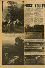
... ...cumberland valley...lake...A newspaper article on some of the local attractions and activities to be seen and done in and around Marysville. marysville victoria australia newspaper article steavenson falls beauty spot walk red hill walk wishing well taggerty river mount gordon keppel's lookout keppel falls old water wheel cumberland valley lake eildon snob's creek fish hatchery alexandra mansfield jamieson wood's point warburton healesville A newspaper article on some of the local attractions and activities to be seen and done in and around Marysville. ...A newspaper article on some of the local attractions and activities to be seen and done in and around Marysville.A newspaper article on some of the local attractions and activities to be seen and done in and around Marysville.marysville, victoria, australia, newspaper article, steavenson falls, beauty spot walk, red hill walk, wishing well, taggerty river, mount gordon, keppel's lookout, keppel falls, old water wheel, cumberland valley, lake eildon, snob's creek fish hatchery, alexandra, mansfield, jamieson, wood's point, warburton, healesville -
 Federation University Historical Collection
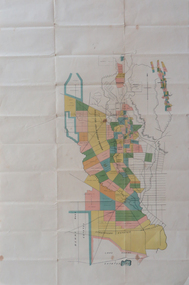
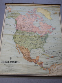
Plan, Berry Bank Estates
... ...happy valley...lake...Gift of the Squire Family berry bank estates mining happy valley lake rosine estates strathvean estates proprietary w. luplaupitfield plateau british banner federal mint moller morrow south pitfield consols east banner new lallah rookh bull dog company mindai j. morpoh poliah f. j. morrow piggoreet east w. m. acheson grand trunk field's claim south grand trunk south grand trunk woady yalloak creek mount misery creek fitzpatric's creek illabrook creek great western mount bute syndicate narringhill creek little woady yalloak creek piggoreet east preemptive right southern birthday new birthday prince of wales collins brassey birthday howarth's lead w. price royal birthday a. clinton victoria express patons williams fancy hennessy queen of the south n pandora proprietary gold estate lyonbank lease rowe's southern rowe's extended w. t. rowe wallinduc company glenfine horseshoe company rowe's glenfine junction wallinduc syndicate pitfield estates rowe's estate southern glenfine h. fields christies & fields balmoral company glenfine united hallett great glenfine rowe consuls nicholls london & melbourne gold mine j. w. pascoe christies glenfine central j. king j. durston great western extended oswald woadyyaloak berringa squire Plan of Berry Bank Estates. ...This plan is associated with former Ballarat School of Mines Student Richard Squire (1875-1876). Gift of the Squire FamilyPlan of Berry Bank Estates. Coloured plan on cream paperberry bank estates, mining, happy valley, lake rosine estates, strathvean estates proprietary, w. luplaupitfield plateau, british banner, federal mint, moller, morrow, south pitfield consols, east banner, new lallah rookh, bull dog company, mindai, j. morpoh, poliah, f. j. morrow, piggoreet east, w. m. acheson, grand trunk, field's claim south grand trunk, south grand trunk, woady yalloak creek, mount misery creek, fitzpatric's creek, illabrook creek, great western, mount bute syndicate, narringhill creek, little woady yalloak creek, piggoreet east preemptive right, southern birthday, new birthday, prince of wales, collins, brassey birthday, howarth's lead, w. price, royal birthday, a. clinton, victoria express, patons, williams fancy, hennessy, queen of the south, n, pandora proprietary gold estate, lyonbank lease, rowe's southern, rowe's extended, w. t. rowe, wallinduc company, glenfine horseshoe company, rowe's glenfine junction, wallinduc syndicate, pitfield estates, rowe's estate, southern glenfine, h. fields, christies & fields, balmoral company, glenfine united, hallett, great glenfine, rowe consuls, nicholls, london & melbourne gold mine, j. w. pascoe, christies, glenfine central, j. king, j. durston, great western extended, oswald, woadyyaloak, berringa, squire -
 Stawell Historical Society Inc
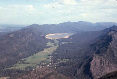
Slide, Ian McCann, Aerial View of Lake Belfield in the distance, 1960's
... Colour Slide: Aerial View of Grampians Valley with lake Bellfield in the distance...Stawell Historical Society Inc 46 Longfield St Stawell grampians Grampians Lake Bellfield Colour Slide: Aerial View of Grampians Valley with lake Bellfield in the distance Aerial View of Lake Belfield in the distance Slide Ian McCann ...Colour Slide: Aerial View of Grampians Valley with lake Bellfield in the distancegrampians, lake bellfield -
 Stawell Historical Society Inc
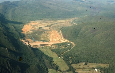
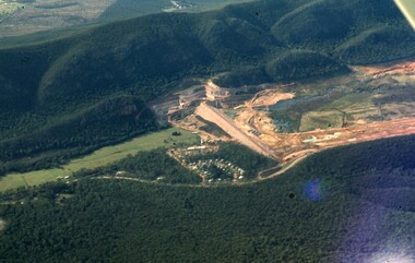
Slide, Ian McCann, Long shot Lake Bellfield being filled, 1960's
... Ariel view, Looking up the valley at lake bellfield being filled...Stawell Historical Society Inc 46 Longfield St Stawell grampians Grampians Ariel view, Looking up the valley at lake bellfield being filled Long shot Lake Bellfield being filled Slide Ian McCann ...Ariel view, Looking up the valley at lake bellfield being filledgrampians -
 Federation University Historical Collection
Book, D.C. Davies et al, Metalliferous Minerals and Mining, 1892, 1892
... valley...wisconsin...lake...Barker Library (top floor) Mount Helen goldfields mining minerals quartz nova scotia california germany ural mountains gold deposits virginia new england new brunswick brazil australia new south wales mount morgan new zealand africa statistics india phillipines aruba island silver russia nevada ruby hill, nevada utah emma mine, nevada colarado red mountain district, colorado yankee girl mine arizona mexico peru bolivia chili\copper south africa italy austria norway swedan france cornwall dolcoath mine sandstone parys mines of anglesea carnarvonshire cardiganshire wicklow, ireland mississippi valley wisconsin lake superior wyoming cuba jamaica venezuela south australia york peninsula flinders ranges japan tin banca malaysia bohemia saxony sweden spain cligga point rin lodes of cornwall andalusia belgium shropshire isle of man durham westmoreland limestone flintshire dengigshire canada lead zinc siberia hungary silesia sardinia algeria ireland new jersey iron lancashire missouri michigan superstitions equipment cages stopes winzes timbering ventilation fans drilling boring dynamite electricity blasting horse whims water wheels boilers petterson's elephant ore stamp stamper battery jogs linkenbach table panning cradle quartz mining hydraulic mining alluvia; mining altai mountains north wales neugluck mine freiberg christbescherung mine drei prinzen lode miask woodville, virginia gongo soco, brazil sierra nevada, california st john del rey mine, brazil leydenberg gold field, south africa banket reefs, transvaal kongsberg, norway santa rosa mine, peru huelva, spain dolcoath mine, cornwall parys mine, anglesea waterbury copper mine, lake superior copiapo, chilli altenberg, saxony whea; uny, cornwall wast wheel mine. redruth, cornwall cligga point, cornwall old hewas mine, cornwall hartz, germany snailbeach mine, shropshire llangynog, north wales van mine, mongomeryshire Brown hard covered, illustrated book of 518 pages. ...Brown hard covered, illustrated book of 518 pages. It includes a bookplate of the Ballarat Ironworkers' and Polytechnical Association Library Rules. The book was bequethed to the Ironworkers' Association by the late James Oddie.mining, minerals, quartz, nova scotia, california, germany, ural mountains, gold deposits, virginia, new england, new brunswick, brazil, australia, new south wales, mount morgan, new zealand, africa, statistics, india, phillipines, aruba island, silver, russia, nevada, ruby hill, nevada, utah, emma mine, nevada, colarado, red mountain district, colorado, yankee girl mine, arizona, mexico, peru, bolivia, chili\copper, south africa, italy, austria, norway, swedan, france, cornwall, dolcoath mine, sandstone, parys mines of anglesea, carnarvonshire, cardiganshire, wicklow, ireland, mississippi valley, wisconsin, lake superior, wyoming, cuba, jamaica, venezuela, south australia, york peninsula, flinders ranges, japan, tin, banca, malaysia, bohemia, saxony, sweden, spain, cligga point, rin lodes of cornwall, andalusia, belgium, shropshire, isle of man, durham, westmoreland, limestone, flintshire, dengigshire, canada, lead, zinc, siberia, hungary, silesia, sardinia, algeria, ireland, new jersey, iron, lancashire, missouri, michigan, superstitions, equipment, cages, stopes, winzes, timbering, ventilation, fans, drilling, boring, dynamite, electricity, blasting, horse whims, water wheels, boilers, petterson's elephant ore stamp, stamper battery, jogs, linkenbach table, panning, cradle, quartz mining, hydraulic mining, alluvia; mining, altai mountains, north wales, neugluck mine, freiberg, christbescherung mine, drei prinzen lode, miask, woodville, virginia, gongo soco, brazil, sierra nevada, california, st john del rey mine, brazil, leydenberg gold field, south africa, banket reefs, transvaal, kongsberg, norway, santa rosa mine, peru, huelva, spain, dolcoath mine, cornwall, parys mine, anglesea, waterbury copper mine, lake superior, copiapo, chilli, altenberg, saxony, whea; uny, cornwall, wast wheel mine. redruth, cornwall, cligga point, cornwall, old hewas mine, cornwall, hartz, germany, snailbeach mine, shropshire, llangynog, north wales, van mine, mongomeryshire -
 Stawell Historical Society Inc
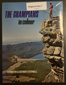
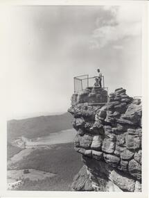
Book, Kenneth & Esther Stepnell, The Grampians in colour, 1972
... Hardcover with Dustjacket: Colour photo of a man overlooking a valley with lake Bellfield from the Pinnacle lookout....Lake Bellfield, Fauna, signpost, Halls Gap, Rockart, Flora. Kenneth Stepnell Photographer. Esther Stepnell selected the photographs and wrote the introduction & captions. Grampians Touruism Inside: Name and address of previous owner Hardcover with Dustjacket: Colour photo of a man overlooking a valley with lake Bellfield from the Pinnacle lookout. ...1972 - Colour photgraphs of Grampians Ranges, Lake Bellfield, Fauna, signpost, Halls Gap, Rockart, Flora. Kenneth Stepnell Photographer. Esther Stepnell selected the photographs and wrote the introduction & captions.Hardcover with Dustjacket: Colour photo of a man overlooking a valley with lake Bellfield from the Pinnacle lookout.Inside: Name and address of previous ownergrampians, touruism -
 Lakes Entrance Historical Society
Album, LERHS members, Honour Boards from East Gippsland Victoria, 2010
... Includes Bruthen, Omeo, Glen Valley, Lakes Entrance, Kalimna, Swan Reach, Tambo Upper, Lake Tyers Rd School, Briagalong, Swifts Creek, Tarraville...Includes Bruthen, Omeo, Glen Valley, Lakes Entrance, Kalimna, Swan Reach, Tambo Upper, Lake Tyers Rd School, Briagalong, Swifts Creek, Tarraville Schools WW1 WW2 Memorials A small album containing photographs of Honour Boards from East Gippsland Victoria. ...Photographs of Honour Boards from around Gippsland. Includes Bruthen, Omeo, Glen Valley, Lakes Entrance, Kalimna, Swan Reach, Tambo Upper, Lake Tyers Rd School, Briagalong, Swifts Creek, TarravilleA small album containing photographs of Honour Boards from East Gippsland Victoria. Please visit L.E. History Centre to view all photos. schools, ww1, ww2, memorials -
 Stawell Historical Society Inc
Slide, Ian McCann, Ariel View of the Construction of Lake Bellfield, 2022
... Ariel View looking up the Valley athte COnstruction of Lake Bellfield...Stawell Historical Society Inc 46 Longfield St Stawell grampians Grampians Lake Bellfield Ariel View looking up the Valley athte COnstruction of Lake Bellfield Ariel View of the Construction of Lake Bellfield Slide Ian McCann ...Ariel View looking up the Valley athte COnstruction of Lake Bellfieldgrampians, lake bellfield -
 Halls Gap & Grampians Historical Society
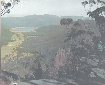
Photograph - B/W, C 1960s
... Photo shows a man and a woman on top of a rocky outcrop that overlook a valley. A lake with a dam wall and rock tiers cut into the hillside can be seen as well as cleared areas some buildings. the lookout is enclosed with a wire fence....Lake Bellfield in the background flanked by the Mt. William range. the photo is typical of 'tourism' photos taken by the Victorian Railways. SCENERY Lookouts Photo shows a man and a woman on top of a rocky outcrop that overlook a valley. ...Photo is of 'The Pinnacle' lookout with Lake Bellfield in the background flanked by the Mt. William range. the photo is typical of 'tourism' photos taken by the Victorian Railways.Photo shows a man and a woman on top of a rocky outcrop that overlook a valley. A lake with a dam wall and rock tiers cut into the hillside can be seen as well as cleared areas some buildings. the lookout is enclosed with a wire fence.scenery, lookouts -
 Stawell Historical Society Inc
Photograph, Fyans Valley in Halls Gap -- Before lake Belfield was constructed
... Fyans Valley in Halls Gap -- Before lake Belfield was constructed...Fyans Valley. Halls Gap. Before lake Belfield constructed....Stawell Historical Society Inc 46 Longfield St Stawell grampians Fyans Valley. Halls Gap. Before lake Belfield constructed. Stawell Fyans Valley in Halls Gap -- Before lake Belfield was constructed Photograph ...Fyans Valley. Halls Gap. Before lake Belfield constructed.stawell -
 Falls Creek Historical Society
Clothing - Shirt Falls Creek Mountain Bike Park Crew
... The graded trails include rides to the Rocky Valley Lake, historic cattlemen’s huts such as Cope Hut and Wallaces Hut, the top of Mt McKay, Pretty Valley Lake and for the experts the ride to Mt Nelse and the Spion Kopje summit. ...The graded trails include rides to the Rocky Valley Lake, historic cattlemen’s huts such as Cope Hut and Wallaces Hut, the top of Mt McKay, Pretty Valley Lake and for the experts the ride to Mt Nelse and the Spion Kopje summit. ...The Falls Creek Mountain Bike Park opened in 2013 with 40 kilometres of trails in the Victorian Alpine National Park. Designed and built by World Trail, the bike trails provide access to beautiful alpine terrain. The rides now extend over more than 50 kilometres, catering for a range of abilities and providing activities in the summer season. All trails start and finish in the resort. The high-altitude trails of Falls Creek include a range of wide gravel roads to winding single trails. The graded trails include rides to the Rocky Valley Lake, historic cattlemen’s huts such as Cope Hut and Wallaces Hut, the top of Mt McKay, Pretty Valley Lake and for the experts the ride to Mt Nelse and the Spion Kopje summit. MTB Bike Patrol Top To ensure rider safety, Falls Creek Resort introduced a Bike Patrol service during shuttle operating hours. Many Ski Patrol members transitioned into these roles, offering riders peace of mind that medical care was available quickly if needed. The program highlighted the resort's commitment to duty of care and to growing mountain biking responsibly. This shirt was designed by Australian Company Dharco as a highly visible uniform for crew at the Falls Creek Mountain Bike Park. Jo Prothero, Director of Marketing for Falls Creek Resort Management from 2012 to 2019, generously donated two mountain bike jerseys that capture a pivotal era in the resort's history. During Jo's tenure, the resort made significant investments in mountain bike trails, aiming to activate the village during the summer months and support local businesses. This development included appointing Blue Dirt as the resort's first shuttle operator, transporting riders from Howman's Gap to the Summit.This shirt is significant as it is representative of the Falls Creek Mountain Bike Park development.A uni-sex style shirt designed to be worn by mountain bike crews in Falls Creek, Victoria. It has multi-coloured panels of black, orange, yellow and grey. It features an image of a mountain biker descending a slope on the front along with the manufacturer's name. Sponsors' logos also feature across the lower backOn front: PARK CREW/ DHARCO On back: Falls Creek Mountain Bike Park On both sleeves: PARK CREWfalls creek mountain bike park, falls creek staff uniform -
 Halls Gap & Grampians Historical Society
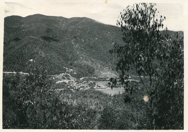
Photograph - B/W
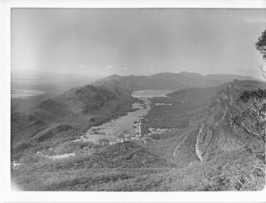
... The Grampians/Dunkeld Road can be seen running North/South along the right edge of the valley and Lake Bellfield is the water at the end of the valley. ...The Grampians/Dunkeld Road can be seen running North/South along the right edge of the valley and Lake Bellfield is the water at the end of the valley. ...Photo has been taken from Boroka Peak/lookout, of the Fyans Valley and the township of Halls Gap. The Grampians/Dunkeld Road can be seen running North/South along the right edge of the valley and Lake Bellfield is the water at the end of the valley. Photo is typical of those taken by Forrests Commission at the timea photo of a valley, mostly cleared, flanked by two mountain ranges. A large body of water can be seen at the far end of the valley (middle of photo). Buildings and roads visible in the valley. Plains can be seen beyond the far mountain range on the left side of the scene.no.42scenery, fyans valley -
 Kiewa Valley Historical Society
Maps - Educational x 10 and Kiewa Scheme x1
... The Kiewa Hydro Electric Works map is pinkish and shows Rocky Valley Dam, Lake Guy and Mt Beauty pondage in dark blue....The Kiewa Hydro Electric Works map is pinkish and shows Rocky Valley Dam, Lake Guy and Mt Beauty pondage in dark blue. ...Maps were used to teach children geography, the explorers, the minerals, the world etc. The school bought and stored the maps so that they were available for use. This predated electronic devices. The KHE Works map was hand drawn showing lots of detail.These maps were used by the Bogong Primary School. The Kiewa Hydro Electric Works was built by the SECV and produced hydro power. This map may have been used by pupils as well as workers on the Works. Large coloured maps on canvas, with a wooden beam along the top and bottom. Each one has a cord attached to the top so that the map may be hung up on a wall. Some are made by Chas. H. Scally & Co., Baronia Ave., Wollstonecraft, N.S.W. The Kiewa Hydro Electric Works map is pinkish and shows Rocky Valley Dam, Lake Guy and Mt Beauty pondage in dark blue.maps, educational maps, geography, primary school, kiewa hydro electric works -
 Bendigo Historical Society Inc.
Photograph - LANDSCAPE VIEW OF VALLEY
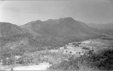
... Hand tinted photo: taken from top of valley, looking down towards lake in background of photo. ...Kennedy Hand tinted photo: taken from top of valley, looking down towards lake in background of photo. ...Hand tinted photo: taken from top of valley, looking down towards lake in background of photo. Man sitting on edge of rock ledge with his back to camera.F.T. Kennedyplace, landscape view, valley -
Federation University Historical Collection
Book, A History of American Mining, 1932
... Chapters include mining in the far north, Comstock Lode, Colorado, Mississippi Valley, Great Salt Lake, Black Hills of South Dakota, Cooper of Lake Superior, copper in Arizona, Bunker Hill Enterprise, Butte The great Diamond Hoax, Flotation Process. ...Chapters include mining in the far north, Comstock Lode, Colorado, Mississippi Valley, Great Salt Lake, Black Hills of South Dakota, Cooper of Lake Superior, copper in Arizona, Bunker Hill Enterprise, Butte The great Diamond Hoax, Flotation Process. ...This book was presented to Charles Bacon by Seeley Wintersmith Mudd.Red hard covered book of 419 pages in the A.I.M.E. Series (American Institute of Mining and Metallurgical Engineering Inc). It includes a presentation Bookplate from Seeley Wintersmith Mudd made out to Charles Bacon. Chapters include mining in the far north, Comstock Lode, Colorado, Mississippi Valley, Great Salt Lake, Black Hills of South Dakota, Cooper of Lake Superior, copper in Arizona, Bunker Hill Enterprise, Butte The great Diamond Hoax, Flotation Process. The book includes some simple maps and plans. The book was dedicated to 'The most distinguished of American mining engineers Herbert Hoover'.t.a. rickard, herbert hoover, seeley wintersmith mudd, bookplate, charles bacon, mining, america -
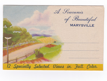
 Marysville & District Historical Society
Postcard (item) - Colour photographs, Nucolorvue Productions, A Souvenir of Beautiful Marysville-12 Specially Selected Views in Full Colour, 1950's
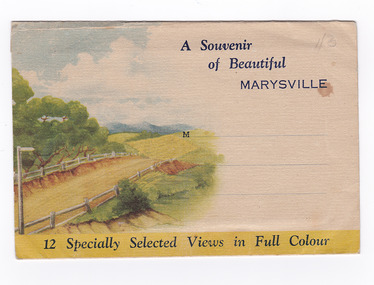
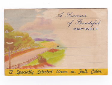
... Apart from many excellent walking trips, Marysville district/ offers ample scope for car trips to the nearby Cumberland Forest,/ Buxton, Narbethong, or the Taggerty Valley. Skiers find Lake Mountain an attraction in the winter, whilst/ the hiker finds ample for his needs in the numerous mountain/ areas. ...Apart from many excellent walking trips, Marysville district/ offers ample scope for car trips to the nearby Cumberland Forest,/ Buxton, Narbethong, or the Taggerty Valley. Skiers find Lake Mountain an attraction in the winter, whilst/ the hiker finds ample for his needs in the numerous mountain/ areas. ...An envelope of 12 colour photographs of attractions in and around Marysville in Victoria.An envelope of 12 colour photographs of attractions in and around Marysville in Victoria. These photographs were produced by Nucolorvue Productions in Mentone, Victoria.A Souvenir of Beautiful MARYSVILLE 12 Specially Selected Views in Full Colour Marysville, Victoria, Australia Marysville, 60 miles from Melbourne, is one of nature's/ lovely beauty spots. The invigorating mountain air helps the/ visitor to enjoy the many delightful walks amongst the tall/ timber, or through the fern glades. Apart from many excellent walking trips, Marysville district/ offers ample scope for car trips to the nearby Cumberland Forest,/ Buxton, Narbethong, or the Taggerty Valley. Skiers find Lake Mountain an attraction in the winter, whilst/ the hiker finds ample for his needs in the numerous mountain/ areas. Huge Eucalypt trees, revealing their ramrod straightness up/ to 300 feet in height, are a fitting background to the many/ beautiful creeks and waterfalls. PUBLISHED BY NUCOLORVUE PRODUCTIONS, MENTONE, VICTORIA.nicholl's lookout (image 1), eildon weir (image 2), road to lake mountain (image 3), foot of steavenson falls (image 4), steavenson falls (image 5), bush scene near marysville (image 6), bush track marysville (image 7), bridge and chalet and crossways marysville (image 8), log cabin at marysville (image 9), black spur (image 10), taggerty river (image 11), highest known hardwood tree (image 12), marysville, victoria, nucolorvue productions, postcard, souvenir -
 Marysville & District Historical Society
Postcard (item) - Colour photographs, Nucolorvue Productions, A Souvenir of Beautiful Marysville-12 Specially Selected Views in Full Colour, Unknown
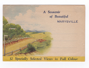
... Apart from many excellent walking trips, Marysville district/ offers ample scope for car trips to the nearby Cumberland Forest,/ Buxton, Narbethong, or the Taggerty Valley. Skiers find Lake Mountain an attraction in the winter, whilst/ the hiker finds ample for his needs in the numerous mountain/ areas. ...Apart from many excellent walking trips, Marysville district/ offers ample scope for car trips to the nearby Cumberland Forest,/ Buxton, Narbethong, or the Taggerty Valley. Skiers find Lake Mountain an attraction in the winter, whilst/ the hiker finds ample for his needs in the numerous mountain/ areas. ...An envelope of 12 colour photographs of attractions in and around Marysville in Victoria.An envelope of 12 colour photographs of attractions in and around Marysville in Victoria. These photographs were produced by Nucolorvue Productions in Mentone, Victoria.A Souvenir of Beautiful MARYSVILLE 12 Specially Selected Views in Full Colour Marysville, Victoria, Australia Marysville, 60 miles from Melbourne, is one of nature's/ lovely beauty spots. The invigorating mountain air helps the/ visitor to enjoy the many delightful walks amongst the tall/ timber, or through the fern glades. Apart from many excellent walking trips, Marysville district/ offers ample scope for car trips to the nearby Cumberland Forest,/ Buxton, Narbethong, or the Taggerty Valley. Skiers find Lake Mountain an attraction in the winter, whilst/ the hiker finds ample for his needs in the numerous mountain/ areas. Huge Eucalypt trees, revealing their ramrod straightness up/ to 300 feet in height, are a fitting background to the many/ beautiful creeks and waterfalls. PUBLISHED BY NUCOLORVUE PRODUCTIONS, MENTONE, VICTORIA.nicholl's lookout (image 1), eildon weir (image 2), road to lake mountain (image 3), foot of steavenson falls (image 4), steavenson falls (image 5), bush scene near marysville (image 6), bush track marysville (image 7), bridge and chalet and crossways marysville (image 8), log cabin at marysville (image 9), black spur (image 10), taggerty river (image 11), highest known hardwood tree (image 12), marysville, victoria, nucolorvue productions, postcard, souvenir -
 Warrnambool and District Historical Society Inc.
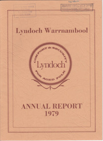
Document - Lyndoch Warrnambool 1979 Annual Report, 1979
... Valley where he had lived. He owned Lyndoch for 44 years and it was his stepdaughter, Florence Lake who built in the 1920s the bungalow known as Lyndoch which forms the original building of the Lyndoch Home for the Aged. ...Valley where he had lived. He owned Lyndoch for 44 years and it was his stepdaughter, Florence Lake who built in the 1920s the bungalow known as Lyndoch which forms the original building of the Lyndoch Home for the Aged. ...This is the 1979 Annual Report for Lyndoch Home and Hospital for the Aged, Warrnambool. It contains lists of Board Members, a President’s Report, a sketch of a proposed new building, financial reports, photographs and a list of Life Governors. Lyndoch Home for the Aged was established in 1952 and has developed with a wide range of facilities for the aged since that date. The original Lyndoch property near the mouth of the river Hopkins was owned by a Melbourne tea merchant, George Rolfe, who bought the land when there were only on the site a couple of cottages and a larger building which had been a school, Warrnambool Grammar, run by Henry Kemmis. Rolfe acquired the land in the 1870s and named the property Lyndoch after the town in the Barossa Valley where he had lived. He owned Lyndoch for 44 years and it was his stepdaughter, Florence Lake who built in the 1920s the bungalow known as Lyndoch which forms the original building of the Lyndoch Home for the Aged. Today the facility is called Lyndoch Living.This report is kept for the benefit of researchers wanting details of the history of Lyndoch over the past thirty or forty years.This is a booklet with a cardboard buff-coloured cover. There are six double-sided pages with printed material on white paper with a yellow and orange stripe across the top of the pages.On front cover: Lyndoch Warrnambool, Annual Report 1979 In brown circle on front cover: Lyndoch, Comfort and Security for Aged Folk Two library stamps on front cover (Warrnambool Library) lyndoch, aged care facility, warrnambool, hopkins, warrnambool grammar -
 Warrnambool and District Historical Society Inc.
Document - Lyndoch Warrnambool 1982 Annual Report
... Valley where he had lived. He owned Lyndoch for 44 years and it was his stepdaughter, Florence Lake who built in the 1920s the bungalow known as Lyndoch which forms the original building of the Lyndoch Home for the Aged, Today the facility is called Lyndoch Living. ...Valley where he had lived. He owned Lyndoch for 44 years and it was his stepdaughter, Florence Lake who built in the 1920s the bungalow known as Lyndoch which forms the original building of the Lyndoch Home for the Aged, Today the facility is called Lyndoch Living. ...This is the 1982 Annual Report for Lyndoch Home and Hospital for the Aged, Warrnambool. It contains lists of Board Members, a President’s Report, Lyndoch’s Aims, financial reports, photographs and a list of Life Governors. Lyndoch Home for the Aged was established in 1952 and has developed with a wide range of facilities for the aged since that date. The original Lyndoch property near the mouth of the Hopkins River was owned by a Melbourne tea merchant, George Rolfe, who bought the land when there were on the site only a couple of cottages and a larger building which had been a school, Warrnambool Grammar, run by Henry Kemmis. Rolfe acquired the land in the 1870s and named the property Lyndoch after the town in the Barossa Valley where he had lived. He owned Lyndoch for 44 years and it was his stepdaughter, Florence Lake who built in the 1920s the bungalow known as Lyndoch which forms the original building of the Lyndoch Home for the Aged, Today the facility is called Lyndoch Living. This 1982 report is kept for the benefit of researchers wanting details of the history of Lyndoch over the past 30 or 40 years. This is a booklet with a plasticized cover with a white back and a multi-coloured front cover. The front cover has a photograph of a Lyndoch building. There are six double-sided pages with printed material and photographs on white paper and a yellow and orange strip across the top of the pages. The pages are stapled.On front cover: Lyndoch Warrnambool Annual Report 1982 Stamp of Warrnambool Library On back cover: A red circle with the words ‘Lyndoch, Comfort and Security for Aged Folk’ lyndoch aged care facility, warrnambool, lyndoch warrnambool -
 Warrnambool and District Historical Society Inc.
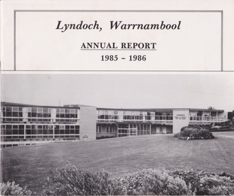
Document - Lyndoch Warrnambool Annual Report 1985-86, 1986
... Valley where he had lived. He owned Lyndoch for 44 years ad it was his stepdaughter Florence Lake who built in the 1920s the bungalow known as Lyndoch which forms the original building of Lyndoch Home for the Aged. ...Valley where he had lived. He owned Lyndoch for 44 years ad it was his stepdaughter Florence Lake who built in the 1920s the bungalow known as Lyndoch which forms the original building of Lyndoch Home for the Aged. ...This is the 1985-6 Annual Report for Lyndoch Home and Hospital for the Aged, Warrnambool. It contains lists of Board Members, a President’s Report, photographs, Lyndoch’s Aims, financial reports and a list of Life Governors. Lyndoch Home for the Aged was established in 1952 and has developed with a wide range of facilities for the aged since that date. The original Lyndoch property near the mouth of the River Hopkins was owned by a Melbourne tea merchant, George Rolfe, who bought the land when there were on the site only a couple of cottages and a larger building which had been a school, Warrnambool Grammar, run by Henry Kemmis. Rolfe acquired the land in the 1870s and named the property Lyndoch after the town in the Barossa Valley where he had lived. He owned Lyndoch for 44 years ad it was his stepdaughter Florence Lake who built in the 1920s the bungalow known as Lyndoch which forms the original building of Lyndoch Home for the Aged. Today the facility is called Lyndoch Living. This 1985-6 report is kept for the benefit of researchers wanting details of the history of Lyndoch over the past 30 or 40 years.This is a booklet with a plasticized white cover with a black and white photograph of a Lyndoch building on the front cover. There are eight double-sided pages with printed material and photographs. The pages are stapled.On front cover: ‘Lyndoch, Warrnambool, Annual Report, 1985-1986 On back cover: A black circle with the words: ‘Lyndoch, Comfort and Security for Aged Folk’. lyndoch aged care facility, warrnambool -
 Kiewa Valley Historical Society
Photo - Bogong Township, March 1944
... Activities such a bike riding, snow skiing, restricted horse riding and bush walking on the Alpine plains and mountains are now a viable part of the Kiewa Valley Tourist Industry. The lake is one of the many water storage reservoirs used to supply the power stations their main power to run the huge turbines generating the final product, electricity Bogong Village SECV Handwritten on the back of photo - Township March '44 Black and white photograph of Bogong Township taken March 1944 Photo - Bogong Township ...In 1940 Field Headquarters for the Kiewa Scheme were established at Bogong with office, workshop facilities and accommodation for workmen, staff and some families constructed. (There had been a 'tent camp' on this site in 1939 but was destroyed by bushfires) Construction of accommodation continued until 1947. A total of 40 houses plus a hostel for single staff, post office, police station, medical centre and primary school all with water and sewerage and electricity supply. The staff hostel was known as Kiewa House and is now occupied by the Education Department. Lake Guy was named after Mr. L.T. Guy who was the Resident Engineer in charge of construction work and associated activities on the Kiewa area. He held this position from 1939 to November 1946 when he was transferred to Head Office. The Bogong Township was developed firstly as an accommodation centre (base camp) for construction workers employed under the Kiewa Hydroelectric Scheme. Due to the influx of European workers into the Township the beautification of the immediate surrounds (gardens etc.) had a distinct European flavour. This environment has been very beneficial for tourism in later years. At the completion of the scheme, in the 1960's, the village was opened to public/tourism use. Strict environmental control has not allowed for any extensive redevelopment in tourist accommodation and basically restricted it to the accommodation initially built for the construction workers. Activities such a bike riding, snow skiing, restricted horse riding and bush walking on the Alpine plains and mountains are now a viable part of the Kiewa Valley Tourist Industry. The lake is one of the many water storage reservoirs used to supply the power stations their main power to run the huge turbines generating the final product, electricityBlack and white photograph of Bogong Township taken March 1944Handwritten on the back of photo - Township March '44bogong village, secv -
 Kiewa Valley Historical Society
Photograph - Bogong Village (7 copies), Approx 1940
... Activities such a bike riding, snow skiing, restricted horse riding and bush walking on the Alpine plains and mountains are now a viable part of the Kiewa Valley Tourist Industry. The lake is one of the many water storage reservoirs used to supply the power stations their main power to run the huge turbines generating the final product, electricity. ...In 1940 Field Headquarters for the Kiewa Scheme were established at Bogong with office, workshop facilities and accommodation for workmen, staff and some families constructed. (There had been a 'tent camp' on this site in 1939 but was destroyed by bushfires) Construction of accommodation continued until 1947. A total of 40 houses plus a hostel for single staff, post office, police station, medical centre and primary school all with water and sewerage and electricity supply. The staff hostel was known as Kiewa House and is now occupied by the Education Department. Lake Guy was named after Mr. L.T. Guy who was the Resident Engineer in charge of construction work and associated activities on the Kiewa area. He held this position from 1939 to November 1946 when he was transferred to Head Office. The Bogong Township was developed firstly as an accommodation centre (base camp) for construction workers employed under the Kiewa Hydroelectric Scheme. Due to the influx of European workers into the Township the beautification of the immediate surrounds (gardens etc.) had a distinct European flavour. This environment has been very beneficial for tourism in later years. At the completion of the scheme, in the 1960's, the village was opened to public/tourism use. Strict environmental control has not allowed for any extensive redevelopment in tourist accommodation and basically restricted it to the accommodation initially built for the construction workers. Activities such a bike riding, snow skiing, restricted horse riding and bush walking on the Alpine plains and mountains are now a viable part of the Kiewa Valley Tourist Industry. The lake is one of the many water storage reservoirs used to supply the power stations their main power to run the huge turbines generating the final product, electricity. Evidence can be seen of the 1939 bushfires.Set of 7 identical black and white photographs of Bogong Village after 1939 bush firesHandwritten on the back of one photo - Bogong Village approx. 1940, after 1939 bush fires. Staff residences to left. Kiewa House, General offices and test lab to the right. Hand drawn map on the back of one photo.bogong village, secv -
 Kiewa Valley Historical Society
Photo - Bogong Village Township, October 8, 1946
... Activities such a bike riding, snow skiing, restricted horse riding and bush walking on the Alpine plains and mountains are now a viable part of the Kiewa Valley Tourist Industry. The lake is one of the many water storage reservoirs used to supply the power stations their main power to run the huge turbines generating the final product, electricity Bogong Village; Lake Guy; Kiewa Hydro Electric Scheme Handwritten on the back - Town of Bogong on a rugged mountain slope above Lake Guy. ...In 1940 Field Headquarters for the Kiewa Scheme were established at Bogong with office, workshop facilities and accommodation for workmen, staff and some families constructed. (There had been a 'tent camp' on this site in 1939 but was destroyed by bushfires) Construction of accommodation continued until 1947. A total of 40 houses plus a hostel for single staff, post office, police station, medical centre and primary school all with water and sewerage and electricity supply. The staff hostel was known as Kiewa House and is now occupied by the Education Department. Lake Guy was named after Mr. L.T. Guy who was the Resident Engineer in charge of construction work and associated activities on the Kiewa area. He held this position from 1939 to November 1946 when he was transferred to Head Office. The Bogong Township was developed firstly as an accommodation centre (base camp) for construction workers employed under the Kiewa Hydroelectric Scheme. Due to the influx of European workers into the Township the beautification of the immediate surrounds (gardens etc.) had a distinct European flavour. This environment has been very beneficial for tourism in later years. At the completion of the scheme, in the 1960's, the village was opened to public/tourism use. Strict environmental control has not allowed for any extensive redevelopment in tourist accommodation and basically restricted it to the accommodation initially built for the construction workers. Activities such a bike riding, snow skiing, restricted horse riding and bush walking on the Alpine plains and mountains are now a viable part of the Kiewa Valley Tourist Industry. The lake is one of the many water storage reservoirs used to supply the power stations their main power to run the huge turbines generating the final product, electricityBlack and white photograph of Bogong Village which appeared in the Herald Sun newspaper on October 8, 1946. Page 13Handwritten on the back - Town of Bogong on a rugged mountain slope above Lake Guy. State Electricity Committee workers on the Kiewa Hydro Electric scheme live here in all electric homes. Stamped on the back - Copyright Not for reproduction Herald Sun Feature Service Melbourne Australiabogong village; lake guy; kiewa hydro electric scheme -
 Kiewa Valley Historical Society
Postcard - Lake Guy and Bogong Village
... Activities such a bike riding, snow skiing, restricted horse riding and bush walking on the Alpine plains and mountains are now a viable part of the Kiewa Valley Tourist Industry. The lake is one of the many water storage reservoirs used to supply the power stations their main power to run the huge turbines generating the final product, electricity Lake Guy Bogong village SECV Handwritten on the back of postcard ' Like most of our camps, this looks like something from the Canadian Rockies' Stamped on the back - Valentine's Post Card A genuine photograph Black and white photographic postcard of Lake Guy and Bogong Village. ...In 1940 Field Headquarters for the Kiewa Scheme were established at Bogong with office, workshop facilities and accommodation for workmen, staff and some families constructed. (There had been a 'tent camp' on this site in 1939 but was destroyed by bushfires) Construction of accommodation continued until 1947. A total of 40 houses plus a hostel for single staff, post office, police station, medical centre and primary school all with water and sewerage and electricity supply. The staff hostel was known as Kiewa House and is now occupied by the Education Department. Lake Guy was named after Mr. L.T. Guy who was the Resident Engineer in charge of construction work and associated activities on the Kiewa area. He held this position from 1939 to November 1946 when he was transferred to Head Office. The Bogong Township was developed firstly as an accommodation centre (base camp) for construction workers employed under the Kiewa Hydroelectric Scheme. Due to the influx of European workers into the Township the beautification of the immediate surrounds (gardens etc.) had a distinct European flavour. This environment has been very beneficial for tourism in later years. At the completion of the scheme, in the 1960's, the village was opened to public/tourism use. Strict environmental control has not allowed for any extensive redevelopment in tourist accommodation and basically restricted it to the accommodation initially built for the construction workers. Activities such a bike riding, snow skiing, restricted horse riding and bush walking on the Alpine plains and mountains are now a viable part of the Kiewa Valley Tourist Industry. The lake is one of the many water storage reservoirs used to supply the power stations their main power to run the huge turbines generating the final product, electricityBlack and white photographic postcard of Lake Guy and Bogong Village. Kiewa Hydro electric Project (showing Junction Dam in front)Handwritten on the back of postcard ' Like most of our camps, this looks like something from the Canadian Rockies' Stamped on the back - Valentine's Post Card A genuine photographlake guy, bogong village, secv -
 Kiewa Valley Historical Society
Photo - Bogong Township, September 1953
... Activities such a bike riding, snow skiing, restricted horse riding and bush walking on the Alpine plains and mountains are now a viable part of the Kiewa Valley Tourist Industry. The lake is one of the many water storage reservoirs used to supply the power stations their main power to run the huge turbines generating the final product, electricity Bogong Village SECV Faded handwritten inscription on back - Bogong Township taken from Little Arthur fire track. ...In 1940 Field Headquarters for the Kiewa Scheme were established at Bogong with office, workshop facilities and accommodation for workmen, staff and some families constructed. (There had been a 'tent camp' on this site in 1939 but was destroyed by bushfires) Construction of accommodation continued until 1947. A total of 40 houses plus a hostel for single staff, post office, police station, medical centre and primary school all with water and sewerage and electricity supply. The staff hostel was known as Kiewa House and is now occupied by the Education Department. Lake Guy was named after Mr. L.T. Guy who was the Resident Engineer in charge of construction work and associated activities on the Kiewa area. He held this position from 1939 to November 1946 when he was transferred to Head Office. The Bogong Township was developed firstly as an accommodation centre (base camp) for construction workers employed under the Kiewa Hydroelectric Scheme. Due to the influx of European workers into the Township the beautification of the immediate surrounds (gardens etc.) had a distinct European flavour. This environment has been very beneficial for tourism in later years. At the completion of the scheme, in the 1960's, the village was opened to public/tourism use. Strict environmental control has not allowed for any extensive redevelopment in tourist accommodation and basically restricted it to the accommodation initially built for the construction workers. Activities such a bike riding, snow skiing, restricted horse riding and bush walking on the Alpine plains and mountains are now a viable part of the Kiewa Valley Tourist Industry. The lake is one of the many water storage reservoirs used to supply the power stations their main power to run the huge turbines generating the final product, electricityBlack and white photograph of Bogong Township taken from Little Arthur fire track. September 1953Faded handwritten inscription on back - Bogong Township taken from Little Arthur fire track. Sept 1953bogong village, secv