Showing 381 items matching "valley view road"
-
 Canterbury History Group
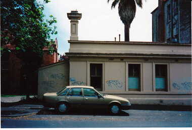
Photograph - Wattle Valley Road street view of the rear of the Canterbury Mansion. Set of 5 photographs, Jan Pigot, 1994
... Wattle Valley Road street view of the rear of the Canterbury Mansion. ...Wattle Valley Road street view of the rear of the Canterbury Mansion. ...Wattle Valley Road street view of the rear of the Canterbury Mansion. ...Wattle Valley Road street view of the rear of the Canterbury Mansion. Also in view is the palm tree on the tree register and the view of the red brick stables. Included is a profile of a Victorian chimney.Colour photographcanterbury, canterbury mansions, shops, wattle valley road, chimneys, stables, palm trees -
 Canterbury History Group
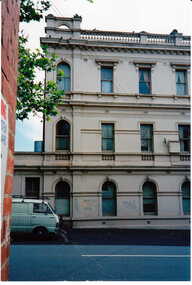
Photograph - Wattle Valley Road view of the Canterbury Mansions. Set of 5 photographs, Jan Pigot, 1994
... Wattle Valley Road view of the Canterbury Mansions. Set of 5 photographs....Canterbury Canterbury Mansions Shops Wattle Valley Road Victorian Architecture Coloured photograph of Photograph Wattle Valley Road view of the Canterbury Mansions. ...Coloured photograph of canterbury, canterbury mansions, shops, wattle valley road, victorian architecture -
 Canterbury History Group
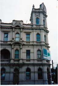
Photograph - Wattle Valley Road view of Canterbury Mansions. Set of 5 photographs, Jan Pigot, 1994
... Wattle Valley Road view of Canterbury Mansions. Set of 5 photographs....Canterbury Canterbury Mansions Shops Wattle Valley Road Signs Victorian architecture Coloured photograph Photograph Wattle Valley Road view of Canterbury Mansions. ...Coloured photograph canterbury, canterbury mansions, shops, wattle valley road, signs, victorian architecture -
 Canterbury History Group
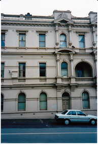
Photograph - Wattle Valley Road view of the Canterbury Mansions. Set of 5 photographs, Jan Pigot, 1994
... Wattle Valley Road view of the Canterbury Mansions. Set of 5 photographs....Canterbury Canterbury Mansions Shops Wattle Valley Road Victorian Architecture Coloured photograph Photograph Wattle Valley Road view of the Canterbury Mansions. ...Coloured photograph canterbury, canterbury mansions, shops, wattle valley road, victorian architecture -
 Canterbury History Group
Photograph - Wattle Valley Road view of the Canterbury Mansions. Set of 5 photographs, Jan Pigot, 1994
... Wattle Valley Road view of the Canterbury Mansions. Set of 5 photographs....Canterbury Canterbury Mansions Shops Wattle Valley Road Victorian Architecture Coloured photograph Photograph Wattle Valley Road view of the Canterbury Mansions. ...Coloured photograph canterbury, canterbury mansions, shops, wattle valley road, victorian architecture -
 Eltham District Historical Society Inc
Negative - Photograph, Popular Picnicing at Hurstbridge, c.1925
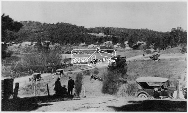
... ...valley view road...In August 1926, 30 picked allotments of 60x150 feet were put up for auction Saturday August 14, 1926 with frontages to Valley View Road and Fawkner Crescent advertised in the “Heart of the Glorious Wattle Country” and “Within 15 Minutes of the Newly Electrified Railway Station”. ...In August 1926, 30 picked allotments of 60x150 feet were put up for auction Saturday August 14, 1926 with frontages to Valley View Road and Fawkner Crescent advertised in the “Heart of the Glorious Wattle Country” and “Within 15 Minutes of the Newly Electrified Railway Station”. ...Picnickers enjoying a Sunday outing near the Wattle Valley Estate at Hurstbridge. Copied from brochure "Wattle Valley Estate". It is believed the picture is taken at the northwest corner of the intersection of Wattletree Road and Hurstbridge-Arthurs Creek Road looking southeast towards the township (most likely where the house is located on the property of what is today No. 2 Wattletree Road)- https://goo.gl/maps/VDorwCe1rJJUapjE6 According to a comment by Jean Verso (via @nillumbikcouncil FB page 3 Jan 2020) - "This view is from Wattle Tree Road with Haleys Gully Road to the right and across the creek to William Gray's nursery at Allwood. The building to the far left looks like Dorset House. The building on the left in the middle distance is still there today and has been used for storage and as a stable/tack room for a number of years." The Wattle Valley Estate was first advertised in August 1925 as weekend building allotments by the Greater Melbourne Land and Development Company. Advertised from £28.10.0 or £60 per block. In August 1926, 30 picked allotments of 60x150 feet were put up for auction Saturday August 14, 1926 with frontages to Valley View Road and Fawkner Crescent advertised in the “Heart of the Glorious Wattle Country” and “Within 15 Minutes of the Newly Electrified Railway Station”. The Advertiser on August 13, 1926 in an article promoting the auction stated “the estate is regarded as one of the best in the district, and will be sold practically without reserve.” It is noted that an advertisement running in The Argus February 22, 1951 offered the remaining 16 blocks for sale at £12.10.0 or £200 the lot. By March 7, the remaining blocks were advertised at £17.10.0 The Wattle Valley Estate took over 20 years to sell and then people could not build on them Cross Ref EDHS_02665 Rose Series Postcard P. 4341, "View at Hurstbridge, Vic." Also, other images from sales brochure SEPP_1055 / 1056This photo forms part of a collection of photographs gathered by the Shire of Eltham for their centenary project book,"Pioneers and Painters: 100 years of the Shire of Eltham" by Alan Marshall (1971). The collection of over 500 images is held in partnership between Eltham District Historical Society and Yarra Plenty Regional Library (Eltham Library) and is now formally known as the 'The Shire of Eltham Pioneers Photograph Collection.' It is significant in being the first community sourced collection representing the places and people of the Shire's first one hundred years.Digital image 4 x 5 inch B&W Neg1925, dorset house, fawkner crescent, haleys gully road, hurstbridge, hurstbridge-arthurs creek road, picnic, postcards, shire of eltham pioneers photograph collection, valley view road, wattle valley estate, wattletree road, exhibition yprl 2019-12 -
 Eltham District Historical Society Inc
Photograph - Postcard, Rose Stereograph Company, View at Hurstbridge, Vic, c.1925
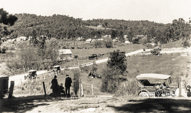
... ...Valley View Road...In August 1926, 30 picked allotments of 60x150 feet were put up for auction Saturday August 14, 1926 with frontages to Valley View Road and Fawkner Crescent advertised in the “Heart of the Glorious Wattle Country” and “Within 15 Minutes of the Newly Electrified Railway Station”. ...In August 1926, 30 picked allotments of 60x150 feet were put up for auction Saturday August 14, 1926 with frontages to Valley View Road and Fawkner Crescent advertised in the “Heart of the Glorious Wattle Country” and “Within 15 Minutes of the Newly Electrified Railway Station”. ...Rose Series Postcard P. 4341 “View at Hurstbridge, Vic.” Picnickers enjoying a Sunday outing near the Wattle Valley Estate at Hurstbridge. Copied from brochure "Wattle Valley Estate". It is believed the picture is taken at the northwest corner of the intersection of Wattletree Road and Hurstbridge-Arthurs Creek Road looking southeast towards the township (most likely where the house is located on the property of what is today No. 2 Wattletree Road)- https://goo.gl/maps/VDorwCe1rJJUapjE6 According to a comment by Jean Verso (via @nillumbikcouncil FB page 3 Jan 2020) - "This view is from Wattle Tree Road with Haleys Gully Road to the right and across the creek to William Gray's nursery at Allwood. The building to the far left looks like Dorset House. The building on the left in the middle distance is still there today and has been used for storage and as a stable/tack room for a number of years." The Wattle Valley Estate was first advertised in August 1925 as weekend building allotments by the Greater Melbourne Land and Development Company. Advertised from £28.10.0 or £60 per block. In August 1926, 30 picked allotments of 60x150 feet were put up for auction Saturday August 14, 1926 with frontages to Valley View Road and Fawkner Crescent advertised in the “Heart of the Glorious Wattle Country” and “Within 15 Minutes of the Newly Electrified Railway Station”. The Advertiser on August 13, 1926 in an article promoting the auction stated “the estate is regarded as one of the best in the district, and will be sold practically without reserve.” It is noted that an advertisement running in The Argus February 22, 1951 offered the remaining 16 blocks for sale at £12.10.0 or £200 the lot. By March 7, the remaining blocks were advertised at £17.10.0 The Wattle Valley Estate took over 20 years to sell and then people could not build on them Cross Ref SEPP_1057, “Popular Picnicing at Hurstbridge” rcopied from Wattle Valley estate sales brochure.Digital file only Postcards scanned from the collection of Michael Aitken on loan to EDHS, 13 Feb 20181925, dorset house, exhibition yprl 2019-12, fawkner crescent, haleys gully road, hurstbridge, hurstbridge-arthurs creek road, michael aitken collection, picnic, postcards, rose stereograph company, shire of eltham pioneers photograph collection, valley view road, wattle valley estate, wattletree road -
 Eltham District Historical Society Inc
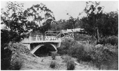
Photograph - Postcard, The Bridge, Hurstbridge, Vic
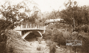
... In August 1926, 30 picked allotments of 60x150 feet were put up for auction Saturday August 14, 1926 with frontages to Valley View Road and Fawkner Crescent advertised in the “Heart of the Glorious Wattle Country” and “Within 15 Minutes of the Newly Electrified Railway Station”. ...In August 1926, 30 picked allotments of 60x150 feet were put up for auction Saturday August 14, 1926 with frontages to Valley View Road and Fawkner Crescent advertised in the “Heart of the Glorious Wattle Country” and “Within 15 Minutes of the Newly Electrified Railway Station”. ...Arched Bridge (Monash Bridge) The Rose Series P. 4036 Reproduced in a brochure advertising the "Wattle Valley Estate" 7 minutes from the bridge. The new bridge designed by Sir John Monash over the Diamond Creek near Hurst's original home "Mia Mia" seen in the distance. The Wattle Valley Estate was first advertised in August 1925 as weekend building allotments by the Greater Melbourne Land and Development Company. Advertised from £28.10.0 or £60 per block. In August 1926, 30 picked allotments of 60x150 feet were put up for auction Saturday August 14, 1926 with frontages to Valley View Road and Fawkner Crescent advertised in the “Heart of the Glorious Wattle Country” and “Within 15 Minutes of the Newly Electrified Railway Station”. The Advertiser on August 13, 1926 in an article promoting the auction stated “the estate is regarded as one of the best in the district, and will be sold practically without reserve.” It is noted that an advertisement running in The Argus February 22, 1951 offered the remaining 16 blocks for sale at £12.10.0 or £200 the lot. By March 7, the remaining blocks were advertised at £17.10.0 The Wattle Valley Estate took over 20 years to sell and then people could not build on them.Digital file only Postcards scanned from the collection of Michael Aitken on loan to EDHS, 13 Feb 2018michael aitken collection, postcards, hurstbridge, monash bridge, bridge, diamond creek (creek), mia mia, shire of eltham pioneers photograph collection, wattle valley estate -
 Eltham District Historical Society Inc
Negative - Photograph, The Bridge, Hurstbridge, Vic, c.1925
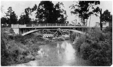
... In August 1926, 30 picked allotments of 60x150 feet were put up for auction Saturday August 14, 1926 with frontages to Valley View Road and Fawkner Crescent advertised in the “Heart of the Glorious Wattle Country” and “Within 15 Minutes of the Newly Electrified Railway Station”. ...In August 1926, 30 picked allotments of 60x150 feet were put up for auction Saturday August 14, 1926 with frontages to Valley View Road and Fawkner Crescent advertised in the “Heart of the Glorious Wattle Country” and “Within 15 Minutes of the Newly Electrified Railway Station”. ...Copied from brochure "Wattle Valley Estate" 7 minutes from the bridge. The new bridge designed by Sir John Monash over the Diamond Creek near Hurst's home of 'Mia Mia' at Hurstbridge. The Wattle Valley Estate was first advertised in August 1925 as weekend building allotments by the Greater Melbourne Land and Development Company. Advertised from £28.10.0 or £60 per block. In August 1926, 30 picked allotments of 60x150 feet were put up for auction Saturday August 14, 1926 with frontages to Valley View Road and Fawkner Crescent advertised in the “Heart of the Glorious Wattle Country” and “Within 15 Minutes of the Newly Electrified Railway Station”. The Advertiser on August 13, 1926 in an article promoting the auction stated “the estate is regarded as one of the best in the district, and will be sold practically without reserve.” It is noted that an advertisement running in The Argus February 22, 1951 offered the remaining 16 blocks for sale at £12.10.0 or £200 the lot. By March 7, the remaining blocks were advertised at £17.10.0 The Wattle Valley Estate took over 20 years to sell and then people could not build on them This image was also used in a brochure advertising the "Wattle Valley Estate", which forms part of the Shire of Eltham Pioneers Photograph Collection (Cross Reference Photo No.(s): 1056, 1057)This photo forms part of a collection of photographs gathered by the Shire of Eltham for their centenary project book,"Pioneers and Painters: 100 years of the Shire of Eltham" by Alan Marshall (1971). The collection of over 500 images is held in partnership between Eltham District Historical Society and Yarra Plenty Regional Library (Eltham Library) and is now formally known as the 'The Shire of Eltham Pioneers Photograph Collection.' It is significant in being the first community sourced collection representing the places and people of the Shire's first one hundred years.Digital image 4 x 5 inch B&W Negshire of eltham pioneers photograph collection, hurstbridge, bridge, diamond creek (creek), monash bridge, wattle valley estate -
 Eltham District Historical Society Inc
Negative - Photograph, Rose Stereograph Company, The Bridge, Hurstbridge, Vic, c.1925
... In August 1926, 30 picked allotments of 60x150 feet were put up for auction Saturday August 14, 1926 with frontages to Valley View Road and Fawkner Crescent advertised in the “Heart of the Glorious Wattle Country” and “Within 15 Minutes of the Newly Electrified Railway Station”. ...In August 1926, 30 picked allotments of 60x150 feet were put up for auction Saturday August 14, 1926 with frontages to Valley View Road and Fawkner Crescent advertised in the “Heart of the Glorious Wattle Country” and “Within 15 Minutes of the Newly Electrified Railway Station”. ...Copied from brochure "Wattle Valley Estate". The new bridge designed by Sir John Monash over the Diamond Creek near Hurst's original home "Mia Mia" seen in the distance. Reprinted from brochure advertising "Wattle Valley Estate" 7 minutes from bridge. The Wattle Valley Estate was first advertised in August 1925 as weekend building allotments by the Greater Melbourne Land and Development Company. Advertised from £28.10.0 or £60 per block. In August 1926, 30 picked allotments of 60x150 feet were put up for auction Saturday August 14, 1926 with frontages to Valley View Road and Fawkner Crescent advertised in the “Heart of the Glorious Wattle Country” and “Within 15 Minutes of the Newly Electrified Railway Station”. The Advertiser on August 13, 1926 in an article promoting the auction stated “the estate is regarded as one of the best in the district, and will be sold practically without reserve.” It is noted that an advertisement running in The Argus February 22, 1951 offered the remaining 16 blocks for sale at £12.10.0 or £200 the lot. By March 7, the remaining blocks were advertised at £17.10.0 The Wattle Valley Estate took over 20 years to sell and then people could not build on them This image was also used in a brochure advertising the "Wattle Valley Estate", which forms part of the Shire of Eltham Pioneers Photograph Collection (Cross Reference Photo No.(s): 1056, 1057). Also cross reference SEPP_1028 / 29 for other views of Mia Mia. Part of a slide show presentation "Bridges & Waterways of the Shire" by Russell Yeoman to the 13 September 1989 Society meeting. The presentation included slides of historic photos from the Shire of Eltham Pioneers collections as well as several recent views. This photo forms part of a collection of photographs gathered by the Shire of Eltham for their centenary project book,"Pioneers and Painters: 100 years of the Shire of Eltham" by Alan Marshall (1971). The collection of over 500 images is held in partnership between Eltham District Historical Society and Yarra Plenty Regional Library (Eltham Library) and is now formally known as the 'The Shire of Eltham Pioneers Photograph Collection.' It is significant in being the first community sourced collection representing the places and people of the Shire's first one hundred years.Digital image 4 x 5 inch B&W Negshire of eltham pioneers photograph collection, hurstbridge, mia mia, bridge, diamond creek (creek), monash bridge, wattle valley estate -
 Kiewa Valley Historical Society
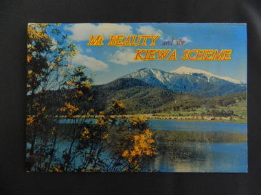
Booklet - Mt Beauty and the Kiewa Scheme x2
... Valley Historical Society Mount Beauty Information Centre 31 Bogong High Plains Rd Mt Beauty high-country This booklet was produced to advertise Mt Beauty, the Kiewa Scheme & surrounding areas to visitors / tourists. The photos cover Falls Creek with snow, lifts and skiers - one with Spion Kopje Lodge. Also Tawonga Camping ground, Bogong Village, Mt Beauty Chalet, the Control panel at Kiewa Power Station, Clover Dam at No. 3 Power Station, the road to Falls Creek and a view ...This booklet was produced to advertise Mt Beauty, the Kiewa Scheme & surrounding areas to visitors / tourists. The photos cover Falls Creek with snow, lifts and skiers - one with Spion Kopje Lodge. Also Tawonga Camping ground, Bogong Village, Mt Beauty Chalet, the Control panel at Kiewa Power Station, Clover Dam at No. 3 Power Station, the road to Falls Creek and a view of Mt Beauty township. The photos indicate what Mt Beauty and the Kiewa Valley and High Plains looked like c1950's during the construction of the Kiewa Hydro Electric Scheme. The area was recognised and encouraged as a tourist attraction especially Falls Creek enabling comparison with later photos and ideas. A fold down booklet postcard size of 12 colored photos - back to back of Mt Beauty, the Kiewa Scheme & surrounds. They fold in to form a front photo with title and a back card for stamp & address of addressee. On the back of the front photo are a few paragraphs describing the beauty, history and 'things to do' in the area for the visitor / tourist. mt beauty; kiewa scheme; tawonga; bogong; clover dam; kiewa valley; bogong high plains -
 Kiewa Valley Historical Society
Photographs – Bogong High Plains - Set of 16 black and white photographs mounted back and front on 3 pieces of heavy black card likely removed from a photograph album
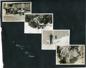
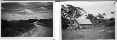
... Some pages display a brief description printed in white ink 1. 4 photographs- displayed diagonally across page. 2 pictures of a group of men standing in the snow in front of a car with a loaded trailer behind. 1 photo of skiers. 1 photo of show hanging in tree branches. 2. 2 photographs- showing Upper Kiewa Road with snow in the background 3. 3 photographs- of skiers and 1 photo of 2 of men posing in the snow & 1 photo of 2 men posing shirtless in warmer weather. 4. 2 photographs- arranged diagonally on page showing early buildings and construction at Bogong Village 5. 2 photographs- 1 showing view of Bogong Village from higher up the mountain. 1 showing early Bogong High Plains road 6. 1 photograph- showing view down along Kiewa Valley from higher up in the mountains ...Some pages display a brief description printed in white ink 1. 4 photographs- displayed diagonally across page. 2 pictures of a group of men standing in the snow in front of a car with a loaded trailer behind. 1 photo of skiers. 1 photo of show hanging in tree branches. 2. 2 photographs- showing Upper Kiewa Road with snow in the background 3. 3 photographs- of skiers and 1 photo of 2 of men posing in the snow & 1 photo of 2 men posing shirtless in warmer weather. 4. 2 photographs- arranged diagonally on page showing early buildings and construction at Bogong Village 5. 2 photographs- 1 showing view of Bogong Village from higher up the mountain. 1 showing early Bogong High Plains road 6. 1 photograph- showing view down along Kiewa Valley from higher up in the mountains Photographs – Bogong High Plains - Set of 16 black and white photographs mounted back and front on 3 pieces of heavy black card likely removed from a photograph album ...After World War II, the Kiewa Hydro-Electric Scheme was started in the Kiewa River Valley by the State Electricity Commission of Victoria. On land previously used only for summer cattle grazing in the natural alpine grasslands, the first ski lodge was built in 1948 by workers from the hydro scheme as skiing was a popular recreation. Many of the hydro employees were of European background and had grown up enjoying skiing and snow sports in their homelands and were keen to continue to pursue their winter sports interests. The first lift, a rope tow, was built at Falls Creek in 1951 and the first chairlift in Australia was constructed there in 1957. Two T-Bars were opened in 1961. In 1964, the Victorian Municipal Directory recorded that Falls Creek had 29 ski club lodges and 16 commercial lodges. The area became a popular tourist destination for both winter and summer sports.Employees of the State Electricity Commission of Victoria in the Kiewa River Valley were the earliest skiers on the Bogong High Plains and built one of the first ski lodges at Falls Creek. They were amongst those pivotal in the development of the skiing and tourist industry at Falls Creek and on the Bogong High Plains. Black and white photographs of varying sizes mounted decoratively on heavy black Card. Some pages display a brief description printed in white ink 1. 4 photographs- displayed diagonally across page. 2 pictures of a group of men standing in the snow in front of a car with a loaded trailer behind. 1 photo of skiers. 1 photo of show hanging in tree branches. 2. 2 photographs- showing Upper Kiewa Road with snow in the background 3. 3 photographs- of skiers and 1 photo of 2 of men posing in the snow & 1 photo of 2 men posing shirtless in warmer weather. 4. 2 photographs- arranged diagonally on page showing early buildings and construction at Bogong Village 5. 2 photographs- 1 showing view of Bogong Village from higher up the mountain. 1 showing early Bogong High Plains road 6. 1 photograph- showing view down along Kiewa Valley from higher up in the mountains 1. Handwritten in white ink – A TRIP TO THE PLAINS 2. Handwritten in white ink – UPPER KIEWA ROAD MT FAINTER IN BACKGROUND 3 – 6. No markings bogong village; upper kiewa road; bogong high plains; falls creek; skiers -
 Kiewa Valley Historical Society
18 small black and white photographs of the Bogong High Plains, 1948
... Photo 12 View along main road. Looking towards Beauty Valley October 1948. ...Photo 12 View along main road. Looking towards Beauty Valley October 1948. ...These photos of the Bogong High Plains were all taken by Ronald George Thorn who was a cadet engineer with the State Electricity Commission. He worked on the Kiewa scheme from 1948 to 1950 doing overhead line construction and maintenance plus electrical design and drawing work. They are from his personal collection and a record of his time in the Kiewa area.Pictorial history of personal involvement in the the early days of the Kiewa Scheme.18 small black and white photographs all taken on the Bogong High Plains.Photo 1 Wallace's Hut. Photo 2 Ruined Castle - Looking towards Pretty Valley December 1948. Photo 3 Ruined Castle - Looking towards Pretty Valley December 1948. Photo 4 Ruined Castle - Looking Down Valley December 1948. Photo 5 - Mt. McKay from Ruined Castle October 1948. Photo 6 View from Rocky Valley Camp October 1948. Photo 7 Mt. Feather Top from Ruined Castle October 1948. Photo 8 View from Ruined Castle looking downwards towards Beauty October 1948. Photo 9 Rocky River from gauging station October 1948. Photo 10 Rocky Valley River from main road October 1948. Photo 11 View along little Arthur Fire Track October 1948. Photo 12 View along main road. Looking towards Beauty Valley October 1948. Photo 13 View from Little Arthur Fire Track October 1948. Photo 14 Frying Pan Spur from Rocky Valley Road October 1948. Photo 15 Mt. Bogong from Big Hill Fire Track October 1948. Photo 16 View from Big Hill Fire Track October 1948. Photo 17 Mt. Feathertop from Ruined Castle October 1948. Photo 18 Mt. Fainter from Ruined Castle October 1948. (All of the above is hand written on the back of photos in ink). bogong high plains; r g thorn; secv; kiewa hydro electric scheme; pictorial history -
 Kiewa Valley Historical Society
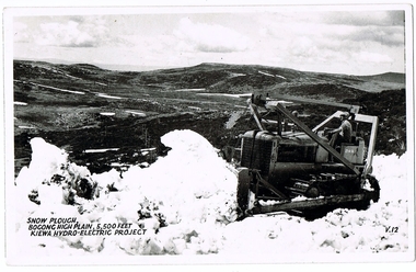
Postcard Circa 1950, Snow Plough, Bogong High Plain,5,500 Feet Kiewa Hydro-Electric Project, Circa 1950
... This postcard was purchased in 1950 by a surveyor at Landford's Gap. kiewa valley tourism victorian alps alternate energy supplies alpine population growth SECV snow plough This item is a black and white photograph(professional) of a panoramic view of a snow plough clearing the unsealed road in 1950.This postcard is on quality paper and the reproduction of the picture is of a high standard.For other "tourist" postcards see 0480 (A) -(F) for other photos of similar postcards. ...This postcard was produced in the 1950's for the tourist trade in the Kiewa Valley and Alpine region. It encompasses the period when the State of Victoria was pressured by the ever increasing demand by industry and its population for electricity supplies. Hydro electricity was seen as an untapped natural resource to quench this demand. The Victorian Alps and the rivers flowing into its valleys was ideal for the construction of the Kiewa Hydro Electricity Scheme. The late 1940's saw the development of this scheme and the changing of sections of alpine landscape is covered by this and other postcards/pictures (tourists, construction workers, and established rural populations). This period in time was before the established wildlife and forest/nature groups became political activist who changed legislative acts to protect the environment. This rural region (Kiewa Valley/alpine plains) was at most only significant to a smaller group of winter sports, summer hikers/horse riders and rural farmers/graziers. The numbers of tourists and the increase in the local resident population was boosted by the construction of the Hydro Electricity Scheme. This influx to the regional population resulted in a corresponding diversity in services and brought about an environment that responded to a growing level of tourists and thereby permitting this industry to grow more rapidly than it would have naturally. This postcard details an attraction to the "cleaner" method of providing electricity. This postcard was purchased in 1950 by a surveyor at Landford's Gap. This item is a black and white photograph(professional) of a panoramic view of a snow plough clearing the unsealed road in 1950.This postcard is on quality paper and the reproduction of the picture is of a high standard.For other "tourist" postcards see 0480 (A) -(F) for other photos of similar postcards. kiewa valley tourism, victorian alps, alternate energy supplies, alpine population growth, secv, snow plough -
 Kiewa Valley Historical Society
16 Photos - A.N. Barnes Collection
... Aerial photo of Tawonga South; Aerial photo of Tawonga South Aerial view of upper Kiewa Valley Clover P{ower Station / No. 3 Power Station Bogong High Country with snow Bogong Village / Lake Guy Lake Guy dam wall spilling with Bogong Village in background The interior of Lake Guy dam wall Bogong Village at night with lights reflecting in Lake Guy Bogong dam wall overflowing Pretty Valley Camp BHP Road to Rocky Valley The workers' camp at Clover Flat Unknown Two unknown men with a vehicle at the top of the Bright Gap note distance and elevations on sign posts and Royal auto signs on arrows SEC Workmen's Camp ...Valley from a rural community to a construction community. Kiewa Hudro Electric Scheme A.N.Barnes Aerial photo of Tawonga South; Aerial photo of Tawonga South Aerial view of upper Kiewa Valley Clover P{ower Station / No. 3 Power Station Bogong High Country with snow Bogong Village / Lake Guy Lake Guy dam wall spilling with Bogong Village in background The interior of Lake Guy dam wall Bogong Village at night with lights reflecting in Lake Guy Bogong dam wall overflowing Pretty Valley Camp BHP Road to Rocky Valley The workers' camp at Clover Flat Unknown Two unknown men with a vehicle at the top of the Bright Gap note distance and elevations on sign posts and Royal auto signs on arrows SEC Workmen's Camp 16 Photos - A.N. ...The State Electricity Commission of Victoria constructed the Kiewa Hydro Electric Scheme which included the townships of Bogong and Mount Beauty - from the late 1940s until 1961 The KHES changed the Kiewa Valley from a rural community to a construction community.Aerial photo of Tawonga South; Aerial photo of Tawonga South Aerial view of upper Kiewa Valley Clover P{ower Station / No. 3 Power Station Bogong High Country with snow Bogong Village / Lake Guy Lake Guy dam wall spilling with Bogong Village in background The interior of Lake Guy dam wall Bogong Village at night with lights reflecting in Lake Guy Bogong dam wall overflowing Pretty Valley Camp BHP Road to Rocky Valley The workers' camp at Clover Flat Unknown Two unknown men with a vehicle at the top of the Bright Gap note distance and elevations on sign posts and Royal auto signs on arrows SEC Workmen's Camp kiewa hudro electric scheme, a.n.barnes -
 Kiewa Valley Historical Society
Set of 6 framed photographs - Kiewa Hydro Electric Scheme
... View from Downstream of Junction Dam - July 1943 6. Upper Kiewa Valley Road 3 to 4 Mile - Mt Arthur in Background - July 1954 ...Valley KHES SECV 1. No. 1 Pipeline - from Anchor 1 to Anchor 5. August 1955 2. Junction Dam - General View from Downstream - May 1943 3. No. 3 Power Station - Clover Flat Camp - February 1951 4. Clover Dam - October 1954 5. View from Downstream of Junction Dam - July 1943 6. Upper Kiewa Valley Road ...Official photo of KHES constructed by SECVOfficial photo of KHES in the Kiewa Valley1. No. 1 Pipeline - from Anchor 1 to Anchor 5. August 1955 2. Junction Dam - General View from Downstream - May 1943 3. No. 3 Power Station - Clover Flat Camp - February 1951 4. Clover Dam - October 1954 5. View from Downstream of Junction Dam - July 1943 6. Upper Kiewa Valley Road 3 to 4 Mile - Mt Arthur in Background - July 1954 khes, secv -
 Kiewa Valley Historical Society
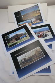
Coloured photographs on paper - Back to Tawonga 2010
... View from Edmondson's Farm - looking north 26. Mount Emu 27. St Aiden's Debutante Ball 27. Grand Opening Ball 1961 Tawonga Hall 28. The Kiewa Valley Road...View from Edmondson's Farm - looking north 26. Mount Emu 27. St Aiden's Debutante Ball 27. Grand Opening Ball 1961 Tawonga Hall 28. The Kiewa Valley Road ...These photos were collected and copied by Di Edmondson for the 'Back To Tawonga' Event in 2010 when she launched her book "Tawonga Remembers".An historical photographic collection of Tawonga and its surrounds, places and people up to 20101. Saw Mill - Mill house 2. The Rock Pool 3. People at the Rock Pool x 2 4.Old Saw mill 5. Back to Tawonga Celebrations x6 6. Tennis Curts opposite the Tawonga Store, Bakery in the background 7. Bowling Club 8. Old Guide Hall 9. The Old Boarding House 10. Old Fire Brigade Shed 11. Building the New Tawonga Memorial Hall 12. Tawonga Go Kart Track - 1960s 13. Tawonga Pony Club 1969 State Championships 14. Tawonga Recreation Reserve Newspaper article 15. The Damm Children 19. 1980s Brian Edmondson, Geoff Edmondson, Mick Harvey, David Piera. Geoff Edmondson's car 20. Tawonga Speedway Track - 1970s Mick Harvey and Paul Harkin's car 21. 2000 22. Tawonga Sports Vera Ryder and Allie Briggs 23. Tawonga School Photos x8 24. Harry Cooper's Farm Looking South 25.View from Edmondson's Farm - looking north 26. Mount Emu 27. St Aiden's Debutante Ball 27. Grand Opening Ball 1961 Tawonga Hall 28. The Kiewa Valley Road at Tawonga. Vic. 29. Tennis Courts opposite the Bogong Hotel 30.Opening of the new Toilet Block in Pioneer park 31. Old Tawonga Store x 3 32. Tawonga Memorial Hall 33. Anglican Church, St Aiden's x 2 34. Motor Khana held at Recreation reserve 35. 1970 State Champioships Team 36. Kiewa Valley School Sports at Dederang 37. Miscellaneous photos x27 Some photos have headings and some headings have been writtentawonga remembers, back to tawonga 2010, di edmondson -
 Kiewa Valley Historical Society
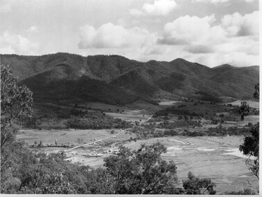
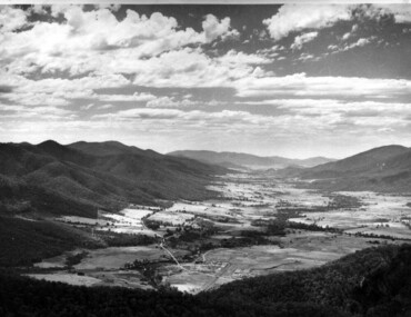
Photograph of Kiewa Valley Panorama, Kiewa Valley from No. 5 Road, Before 1945
... The No. 5 Road, from where the photograph was taken, is the road to West Kiewa Power Station and Big Hill Scenic Lookout. Is an excellent view of the Kiewa Valley before there was little work undertaken to establish the town of Mt. ...In 1943 a camp for workmen was erected and a commencement made with the erection of plant storage and workshop buildings in the new township of Mt. Beauty. The photograph was probably taken after the completion of these buildings. There is no sign of construction of the town itself. In the latter part of 1945 work was commenced on the Mt. Beauty township area with a medical centre, general trading store and some houses under construction. The No. 5 Road, from where the photograph was taken, is the road to West Kiewa Power Station and Big Hill Scenic Lookout.Is an excellent view of the Kiewa Valley before there was little work undertaken to establish the town of Mt. Beauty. Farming was well established with the evidence of huge areas of cleared land. The junction of the East and West Kiewa Rivers can be clearly seen. The first Workmen's camp is near the river and some workshop buildings can also be seen. Black and white photograph of the Kiewa Valley, looking North.Handwritten on the back of photograph "Kiewa Valley from No. 5 Road".kiewa valley, camp, buildings, mt. beauty -
 Kiewa Valley Historical Society
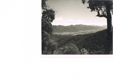
Photograph of Kiewa Valley Panorama, Farming lands within the Kiewa Valley in1950s, Circa 1950
... The Kiewa Valley is loosing its hiding place and is becoming more and more a source of untapped residential land. kiewa valley in the early1900s grazing in the kiewa valley sec victoria Black and white photograph of farming/grazing land useage, before the establishment of the Mount Beauty Village. Small pockets of residentual houses can be viewed. Road ...This photograph shows how (early to mid1900s), before the establishment of the Mount Beauty "gated" village, the Kiewa Valley was farmed and the scarce population was spread out over acres of productive land. This photograph catches a time before (what appeared to the local farmers as the invasion by a mass of construction workers) when this remote valley was part of a "lay back" rural landscape,occasionally visited by friends and some wayward tourists. The mountain ranges provided an adequate barrier against the way-would traveller. The immigration numbers coming into Australia was still quite small ( due to the "white" Australia policy) which was in force before World War II. After World War II a mass of displaced European refugees and migrants boosted the Australian population and provided for a greater degree of diverse professions and rural related work force.This photograph depicts the borderline in time between an exclusively rural based population and respective activities(early 1900s)to the present (2000 on wards) integrated village, tourist and retiree/holiday area. The time when land was exclusively used in agriculture is over and the impact of cheaper rural produce from Asian markets will see a shift of land useage and population activities. The Kiewa Valley is loosing its hiding place and is becoming more and more a source of untapped residential land. Black and white photograph of farming/grazing land useage, before the establishment of the Mount Beauty Village. Small pockets of residentual houses can be viewed. Road access (unsealed dirt) was typical of that provided in rural regions in the 1950s. The photo is on 200gms paper and not on photographic paper.kiewa valley in the early1900s, grazing in the kiewa valley, sec victoria -
 Emerald Museum & Nobelius Heritage Park
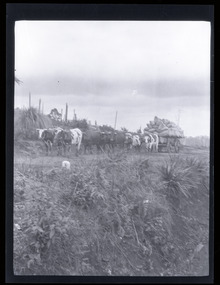
Negative - Image of Bullock Team, Baker & Rouse, Early20th century
... valley-and-the-dandenong-ranges This negative is part of a batch of ten negatives apparently taken around the same time at Gembrook c. early 20th century. This one is of a bullock team pulling a cart loaded with bags of possibly potatoes or grain. There are two other photos of this same bullock team taken in the batch. These negatives provide a glimpse of the early 20th century cartage in Gembrook. Gembrook bullock team early 20th century Handwritten on packet: 'Bullock train on road / Gembrook' Portrait view ...This negative is part of a batch of ten negatives apparently taken around the same time at Gembrook c. early 20th century. This one is of a bullock team pulling a cart loaded with bags of possibly potatoes or grain. There are two other photos of this same bullock team taken in the batch. These negatives provide a glimpse of the early 20th century cartage in Gembrook.Portrait view, black and white photograph of bullock team pulling a cart loaded with sacks of possibly potatoes or grain in Gembrook circa early 20th century. Negative has been kept in a packet which is not original.Handwritten on packet: 'Bullock train on road / Gembrook'gembrook, bullock team, early 20th century -
 Emerald Museum & Nobelius Heritage Park
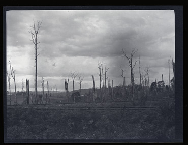
Negative - Image of The Railway Line, Baker & Rouse, Early 20th century
... Emerald Museum & Nobelius Heritage Park 5 Crichton Rd Emerald yarra-valley-and-the-dandenong-ranges This negative is one of a batch of ten images taken apparently around the same time at Gembrook c. early 20th century. This one is of the Ferntree Gully to Gembrook railway line, which was completed in December 1900. The view looks northwards to the hills from probably present-day Station Road ...This negative is one of a batch of ten images taken apparently around the same time at Gembrook c. early 20th century. This one is of the Ferntree Gully to Gembrook railway line, which was completed in December 1900. The view looks northwards to the hills from probably present-day Station Road. This stark image of bare landscape with dead trees recalls both the early timber industry in Gembrook and the practice of wide-spread clearing of land for farming use.Black and white negative - landscape view - of the railway line at Gembrook. The railway is in the foreground. The landscape is bare apart from dead and ringbarked trees. Negative has been kept inside a packet which is not original.Handwritten on (not original) packet containing negative: 'Railway line & dead trees /Gembrook'gembrook, timber industry, railway, 1900, early 20th century, station rd -
 Eltham District Historical Society Inc
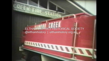
Film - Video (VHS), Diamond Creek Fire Brigade, c.1955-1987
... road. Diamond Creek members identified wearing a diamond on their chest and back. Includes scenes of Scottish pipe bands at the events and significant crowds of spectators. Footage of Mel Stone and Beryl Marks, Stan Redpath and Ron Kirkbride, then Ron Kirkbride and Eric Holt viewing flower displays. Film changes to colour at Diamond Creek oval for practice with fire engine entering oval. Members depicted include Bill May, Jack Sinclair, Jim Cox, Bob Beale, Dave Kidd, Bruce Hackett and Captain Clarrie Stone. Reverts to black and white in the 1950s where the Brigade joins forces with the Diamond Valley...road. Diamond Creek members identified wearing a diamond on their chest and back. Includes scenes of Scottish pipe bands at the events and significant crowds of spectators. Footage of Mel Stone and Beryl Marks, Stan Redpath and Ron Kirkbride, then Ron Kirkbride and Eric Holt viewing flower displays. Film changes to colour at Diamond Creek oval for practice with fire engine entering oval. Members depicted include Bill May, Jack Sinclair, Jim Cox, Bob Beale, Dave Kidd, Bruce Hackett and Captain Clarrie Stone. Reverts to black and white in the 1950s where the Brigade joins forces with the Diamond Valley ...Combination of three movie films. Movie One (1950s): 00:00 – 13:14 Black and white footage of Diamond Creek firemen practising in Diamond Street in the 1950s for forthcoming demonstrations of abilities. Mentions of Gordon Brandy and Joe Hislop Running out hoses from old hose reels along Diamond Street, Diamond Creek Displays from various brigades running out and connecting hoses. Also scenes from the 1950s of Diamond Creek Fire Brigade competing in various locations around Victoria and Tasmania. Mentions of Brigade members Dave Kidd, Bruce Hackett, Ron Kirkbride, Jack Marks, Graham Upton who are prominent in these events. Members of Kyneton Fire Brigade also present. Members competing in running out hose reels, connecting hoses togethers and to hydrants then climbing towers to direct water from hose or at a target hanging above the road. Diamond Creek members identified wearing a diamond on their chest and back. Includes scenes of Scottish pipe bands at the events and significant crowds of spectators. Footage of Mel Stone and Beryl Marks, Stan Redpath and Ron Kirkbride, then Ron Kirkbride and Eric Holt viewing flower displays. Film changes to colour at Diamond Creek oval for practice with fire engine entering oval. Members depicted include Bill May, Jack Sinclair, Jim Cox, Bob Beale, Dave Kidd, Bruce Hackett and Captain Clarrie Stone. Reverts to black and white in the 1950s where the Brigade joins forces with the Diamond Valley Community Hospital for a Gala Day on the Diamond Creek Oval. Changes to colour again, possibly same event and scenes of children on bikes and scooters or with prams and carts racing around the oval. Mention of young lad Brian Laurie who has his own fire truck. Dart throwing, pony rides. Scenes with Dr Don Cordner, Gus Lyons, Vic Cohn (?) and spinning wheel and Diamond Creek School children entertain a large crowd with Maypole dancing. Movie Two (1950s): 13:25 – 19:00 This black and white film was taken by a TV film crew in the 1950s depicts a typical call out for the Diamond Creek Fire Brigade. In this case the careless action of a member of the public throwing a lighted match from a car, which can cause extensive damage. Footage features the Shire of Eltham War Memorial tower at Kangaroo Ground before it was modified with a fire spotter’s cabin. Discusses fire spotting operations from the tower. Shows a fire spotter walking around the top of the tower. A fire is detected, and the information is relayed to the nearest fire station, in this case, Diamond Creek. The telephone call is received, and the alarm sounded. Captain Clarrie Stone and firemen May and Shaw leave their workplaces and prepare for action. Scenes of running across the Main Hurstbridge road showing the shops (Shell service station and Chemist prominent). Scenes entering the fire station which has a pictorial warning covering the entire door “Only you can prevent forest fires – If you’re careless – we’re homeless!” Eric Holt pinpoints the location of the fire while Captain Clarrie Stone and Fireman Shaw take note. The advance vehicle (an FE Holden ute, rego GTE-696) leaves to assess the extent of the fire. Having assessed the fire, Fireman Shaw communicates with base showing radio with call sign VL3JZ. Eric Holt takes the call. In the meantime, Captain Clarrie Stone and Fireman Shaw undertake some limited action to address the fire. Firemen Bill May, Jim Bates and Hugh Bar (?) man the tanker. A photo portrait of Queen Elizabeth is visible hanging on the wall. They are later joined by Firemen Jim Cox, Eric DeBuse (?) and Jack Marks. The tanker is seen departing the station and diverging off before the bridge. Captain Clarrie Stone and Fireman Shaw are seen pumping water on the flames with hand pumps when the tanker arrives. The hose is unreeled, and water turned on the flames. Jack Sinclair joins the action. Jim Cox directs water to the high stuff. The fire put out, Jack Marks and Eric DeBuse wind in the hoses and the team head back to town. It’s peaceful again at the memorial tower. Movie Three (1969-1987): 19:14 – 34:34 Colour film “Fired with Dedication”, Country Fire Authority Victoria, produced by I.L. Wadeson, Commentary by A.M. Hem. Credits with CFA Victoria emblem and then placed over a view of an old-style ladder engine. Opens with the scene of a fire engine outside the Diamond Creek Fire Station then various trophies reflecting the competition success of the brigade in various track and disciplined events. Two trophies shown of particular pride to the brigade were for first place in the Torchlight Procession at the State Championships in Mildura in 1986 and also at Swan Hill in 1981. Still photo scenes of ex Captain Clarrie Stone, Brigade Captain for 21 years; ex Captain Jack Marks, 10 years; ex Captain Ian Douglas, 10 years. Cuts to scene of radio control room, January 1969, and news of a fire on the northern side of the township of Diamond Creek. With scenes of flames in bush, the narration explains that until the early 1960s the area was an orchard district which protected the town against the savagery of bushfires. But due to competition from other areas more suitable for orcharding and easier transport to Melbourne the district could no longer remain competitive, and orchards were replaced by grassed areas, which together with the bush areas were a feeding ground for fire. On 8th January 1969, high temperatures and strong north winds, were, with the carelessness of some individual all that was necessary to produce the worst fire the district had seen. Cuts to scene of blackened fields and cattle - Hundreds of hectares of grass land were blackened, and cattle had to be transported to other areas for agistment. Scene of destroyed buildings in the township – 13 houses and the public hall in the town were destroyed as was the theatre equipment which was owned by the fire brigade. The Church of England Hall and bell tower were badly damaged. The whole town could have been burnt out but for the determination, skill, and courage of the Diamond Creek Fire Brigade. Scenes of all that was left of the home on the hill on the west side of the Church of England. Also, the remains of the old Pisy (?) home on the top of the same hill near Lambert Street, and the ruined Crocker home. Cuts to a scene in the mid-1970s to mid-1980s of a house fire in Haley Street attended by the Diamond Creek Fire Brigade. Although the house was severely damaged, it was saved. Mentions that whilst assistance is appreciated, in some circumstances, those doing so are not properly dressed for fighting fires. Breathing apparatus is a must in structure fire attack. Next scene (either on Mangarook or Coventry oval) showing off four Diamond Creek Fire Brigade efficient and very expensive firefighting units. Features a forward control vehicle Toyota 4WD used for conveying task force personnel to the required areas; a Hino Model 3.2 tanker, diesel powered and carries 3,000 litres of water and has a 16 HP petrol driven pump which delivers 900 litres of water per minute; an International tanker (registration TCM-418) which carries 3,000 litres of water with pumping capacity of 600 litres per minute. The Ford diesel powered pumper (registration MXE-754) is a well-equipped vehicle with a water capacity of 1,000 litres and capable of pumping 1,900 litres of water per minute from the main pump, has many lockers which hose equipment such as breathing apparatus and various types of hose nozzles and foam making equipment. The vehicle carries 360m of 64mm diameter hose which can be laid out from the rear lockers and a portable lighting plant, an Oxy Viva resuscitator to revive smoke inhalation victims and forcible entry tools to gain access to structure fires. Views of the main pump and control panel on the vehicle. As well as the main pump, the vehicle is equipped with an auxiliary pump which allows the facility to pump whilst moving. Fire fighters must undergo constant training and hone their skills, Scenes of a training exercise using the pumper to pump from static water. First, the short lengths of suction hose are coupled, a strainer fitted to ensure debris does not foul the pump. Gauges must be constantly monitored to ensure manageable water pressures are maintained. Pressures are normally controlled to allow two fire fighters to work at each nozzle outlet. Two nozzles are tested, one adjustable jet fog type which is used on flammable gasses or within a structure fire to absorb heat. A straight jet nozzle to project water long distances to protect exposed surfaces close to a fire radiated heat. The pumper is quite a versatile vehicle in handling structure fires, but it also carries specialist equipment needed in containing hazardous chemical incidents. Cuts to scene of parade – the Diamond Creek Fire Brigade has with other neighbouring brigades participated in most town fairs and earns the respect of the watching public. It can be seen why this brigade has been so successful at disciplined contests. Views of Plenty Fire Brigade Road Rescue unit which is equipped with the “Jaws of Life” Scenes of athletic competitions – many neighbouring brigades indulge in friendly but keen competition at the Diamond Creek Town Fair. The young are also encouraged to participate in all aspects of Junior Fire Brigade activities and become tomorrow’s generation of volunteer fire fighters. Scene of the 1986 Diamond Creek Town Fair which was the last time veteran Captain Clarrie Stone BEM marched with the brigade. Clarrie was awarded the British Empire Medal for his service to the Country Fire Authority. Also, scenes of vehicles in the parade. Cuts to scene of brigade members in drill formation for inspection by Acting Chief Harry Rothsay (?) on the occasion of the opening of the new fire station extensions on August 29, 1987. Rudy Libel (?) Captain at the time. Scenes of crowds including many dignitaries of neighbouring brigades present including Lieutenant Gordon Grandy (who came down from Queensland for the occasion) and ex-Secretary David Kidd and wife Betty, also ex Captain Clarrie Stone and Mrs Nel Stone, a life member of the Ladies Auxiliary, the Reverend Jock Ryan, son of J.L Ryan, founder of the Diamond Creek Fire Brigade, Foundation Captain of the fire brigade, Keith Bradbury and Mrs Bradbury. Pauline Dick accepts a community service award for services to the CFA. Recognising over 47 and a half years of service, a presentation is made by Mr Neil Marshall, Acting Chairman of the CFA to ex Captain Clarrie Stone with response by Clarrie. Other members of the official party include Cr. Martin Wright, Shire President Wayne Phillips and local Member of Parliament, Mrs Pauline Toner. Ex foreman John Bennett is presented with a life member’s awards by Captain Rudy Libel. The camera also catches Gwen Cox, Jean Ryan and Bessie Layton (?) Provides historic footage of people, places and equipment and a record of the worst fires expoerienced in Diamond Creek in 1969BASF Standard Quality SQ E-180 VHS dubbing (poor quality) of three films Converted to MP4 file format 0:34:38, 1.85GBOn label: "Donation - August 2000 Diamond Creek Unit Old films made up from Fire Brigade shows at competitions - also Kangaroo Ground Tower being used"video recording, diamond creek fire brigade, 1986 diamond creek town fair, a.m. hem, acting chief harry rothsay, athletic competitions, beryl marks, bessie layton, betty kidd, bill may, bob beale, brian laurie, bruce hackett, captain clarrie stone, chemist, church of england hall, clarrie stone, clarrie stone bem, country fire authority victoria, coventry oval, cr. martin wright, crocker home, dart throwing, dave kidd, david kidd, diamond creek, diamond creek fire station, diamond creek oval, diamond creek school, diamond creek town fair, diamond street, diamond valley community hospital, dr don cordner, eric debuse, eric holt, fe holden ute, fire damage – buildings, fire spotter, fire spotter’s cabin, fire station extension, fired with dedication (film), firefighting units, fireman shaw, firemen jim cox, ford pumper, foundation captain, gala day, gordon brandy, gordon grandy, graham upton, gus lyons, gwen cox, haley street, hino model 3.2 tanker, house fire, i.l. wadeson, ian douglas, international tanker, j.l ryan, jack marks, jack sinclair, january 1969, jaws of life, jean ryan, jim bates and hugh bar, jim cox, joe hislop, john bennett, kangaroo ground, kangaroo ground tower, keith bradbury, kyneton fire brigade, lambert street, main hurstbridge road, mangarook oval, maypole dancing, mel stone, mildura 1986, mrs bradbury, mxe754 vic registration, neil marshall, nel stone, orchard district, oxy viva resuscitator, pauline dick, pauline toner mp, pisy home, plenty fire brigade road rescue unit, pony rides, radio control room, reverend jock ryan, ron kirkbride, rudy libel, shell service station, shire of eltham war memorial, shire president wayne phillips, spinning wheel, stan redpath, state championships, swan hill 1981, tcm418 vic registration, torchlight procession, toyota 4wd, trophies, vic cohn, victorian bushfires - 1969, vl3jz -
 Eltham District Historical Society Inc
Document - Folder, Ness family
... Valley Arts Society float and enclosed 3 drawings and a photograph of drawing of the bakers (corner Main Road and York Street Eltham). Eltham District Historical Society newsletter September 2013: "Vale Joy Ness", obituary and extract from Diamond Valley News article of 6 December 2000. Ness family Kangaroo Ground James Johnston Kangaroo Ground Pretty Hill farm Wellers Hotel Betsy Sadler Ingleside Kangaroo Ground James Mess Jane Stevenson Ness Lane Kangaroo Ground View ...James Johnston settled at Kangaroo Ground in 1849. His nephew James Mess joined him and a descendant Robert James Mess changed his surname to Ness. The family became active in all aspects of Kangaroo Ground life. Contents Text (handwritten and transcribed): "The Ness Family, Kangaroo Ground", Joy Ness, 1989. Newspaper article: "True pioneer stock", Diamond Valley News, 2 March 1982. History of the Mess/Ness family Newspaper article: "Ness family are keepers of 140 years of historical knowledge", Diamond Valley News, 4 February 1986. History of Joseph Stephenson and descendants. Newspaper article: "Joy Ness paints native flowers for posterity". Diamond Valley News, 21 October 1986. Life and career of Joy Ness as painter. Newspaper article: "His Cup runneth of with Joy", ?Diamond Valley Leader, 6 December 2000. Bruce and Joy Ness celebrate 60th wedding anniversary. Pencil sketch by Joh Ebeli no date but pre 2004: Portrait of Joy Ness dressed for the Historical Society Parade. Order of Service: Thanksgiving service for the life of Robert Bruce Ness 22 January 1917 / 28 June 2004. Eltham District Historical Society newsletter no date: "Robert Bruce Ness 1917-2004", obituary and extract from Joy Ness's history of the family. Copy of letter from Joh Ebeli to Gwen Orford, no date but ~2004: Describes drawings he made of Robert Bruce Ness when taking part in Diamond Valley Arts Society float and enclosed 3 drawings and a photograph of drawing of the bakers (corner Main Road and York Street Eltham). Eltham District Historical Society newsletter September 2013: "Vale Joy Ness", obituary and extract from Diamond Valley News article of 6 December 2000.Newspaper clippings, A4 photocopies, etcness family kangaroo ground, james johnston, kangaroo ground, pretty hill farm, wellers hotel, betsy sadler, ingleside kangaroo ground, james mess, jane stevenson, ness lane kangaroo ground, view hill kangaroo ground, stte savings bank agency, ruth lettice gosling nee mess, kangaroo ground state school, garden hills kangaroo ground, william mess, joseph mess, isabella mess, james johnson mess, ruth ettie mess, george mess, alexander mess, janes mess, robert david mess, heidelberg agricultural show, diamond creek agricultural show, rober james ness, pearl ness nee mills, william mills, sabina mills, robert bruce ness, beryl ness, vera ness, donald ness, kangaroo ground presbyterian church, kangaroo ground cemetery trust, kangaroo ground tennis club, professor osborne, doctor osborne, joseph stevenson, joy ness, kangaroo ground fire brigade, bruce ness, country fire authority, ship wellington 1837, diamond creek, david christmas, christmas hills, andres harkness, samuel furphy, andrew ross, caledonian gold fields, queenstown now st andrews, mother coleman of kangaroo ground, diamond valley arts society, winifred joy ness, andrew ross museum, eltham art show -
Eltham District Historical Society Inc
Document - Folder, Sartori, Alan
... Road; he also wrote a book "Alan Sartori's Stories" in 1992. He died in 2007. Contents Newspaper article: "Alan's artful life", Diamond Valley News, 23 November 1992. Alan Sartori to exhibit at his studio in November and December 1992. Newspaper article: "Artist paints views...Road; he also wrote a book "Alan Sartori's Stories" in 1992. He died in 2007. Contents Newspaper article: "Alan's artful life", Diamond Valley News, 23 November 1992. Alan Sartori to exhibit at his studio in November and December 1992. Newspaper article: "Artist paints views ...Alan Sartori became an artist in 1974, moving from Greensborough to live and have his studio at Diamond Creek, 100 Iron bark Road; he also wrote a book "Alan Sartori's Stories" in 1992. He died in 2007. Contents Newspaper article: "Alan's artful life", Diamond Valley News, 23 November 1992. Alan Sartori to exhibit at his studio in November and December 1992. Newspaper article: "Artist paints views of his state", Diamond Valley newspaper, no date. Alan Sartori to exhibit at his studio in November and December that year. Newspaper article: "Loss of an 'amazing' extrovert", Report of funeral of Alan Sartori. Newspaper article: "Art and memories", Diamond Valley newspaper, no date. An exhibition to be held of the late Alan Sartori's work at his studio. Newspaper clippings, A4 photocopies, etcalan sartori, 100 ironbark road diamond creek, cerel sartori, irma sartoria, g j coles, tony summers, martyn thompson, rotary club greensborough, victorian artists society, nillumbik artists open studios -
 Eltham District Historical Society Inc
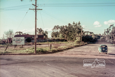
Slide, Site for the new Apex-Diamond Valley Ambulance Station, corner of Main Road and Grand Boulevard, Montmorency, July 1969, 1969
... View looking west along Grand Boulevard from the intersection with Main Road and Panorama Avenue, Montmorency showing the site for the new Apex-Diamond Valley Ambulance Station and before construction of Apex Way, July 1969. ...Eltham District Historical Society Inc 728 Main Rd Eltham melbourne View looking west along Grand Boulevard from the intersection with Main Road and Panorama Avenue, Montmorency showing the site for the new Apex-Diamond Valley Ambulance Station and before construction of Apex Way, July 1969. ...View looking west along Grand Boulevard from the intersection with Main Road and Panorama Avenue, Montmorency showing the site for the new Apex-Diamond Valley Ambulance Station and before construction of Apex Way, July 1969. The Eltham Apex Club conducted a Community Service Project (1965-1968) to raise funds for a new Ambulance Station to service the community. A site bounded by the intersection of Main Road, Grand Boulevard and Looker Road at Montmorency was purchased in 1969. In 1970, Eltham Shire Council undertook roadworks to construct Apex Way in preparation for the new station as well as duplicate Main Road, Lower Plenty, east of Grand Boulevard including the new Lower Plenty Bridge, which had been opened in November 1966, bordering with the City of Heidelberg.35 mm colour positive transparency Mount - Agfacolor Service (Blue)1969-07, ambulance station, apex way, grand boulevard, lower plenty, main road, montmorency, eltham ambulance station, apex-diamond valley ambulance station, eltham apex club -
 Eltham District Historical Society Inc
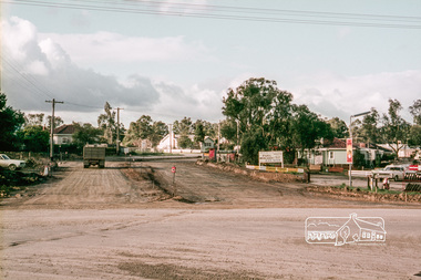
Slide, Reconstruction of Grand Boulevard viewed from Panorama Avenue, Montmorency, 18 August 1970, 1970
... In 1970, Eltham Shire Council undertook roadworks to construct Apex Way in preparation for the new station as well as duplicate Main Road, Lower Plenty, east of Grand Boulevard including the new Lower Plenty Bridge, which had been opened in November 1966, bordering with the City of Heidelberg. 1970-08-18, Apex-Diamond Valley Ambulance Station, Eltham Ambulance Station, Eltham Apex Club, Grand Boulevard, Montmorency 35 mm colour positive transparency Mount - Agfacolor Service (Blue) Reconstruction of Grand Boulevard viewed from Panorama Avenue, Montmorency, 18 August 1970 Slide ...The Eltham Apex Club conducted a Community Service Project (1965-1968) to raise funds for a new Ambulance Station to service the community. A site bounded by the intersection of Main Road, Grand Boulevard and Looker Road at Montmorency was purchased in 1969. In 1970, Eltham Shire Council undertook roadworks to construct Apex Way in preparation for the new station as well as duplicate Main Road, Lower Plenty, east of Grand Boulevard including the new Lower Plenty Bridge, which had been opened in November 1966, bordering with the City of Heidelberg.35 mm colour positive transparency Mount - Agfacolor Service (Blue)1970-08-18, apex-diamond valley ambulance station, eltham ambulance station, eltham apex club, grand boulevard, montmorency -
 Eltham District Historical Society Inc
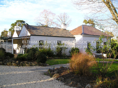
Photograph, Fay Bridge, Rosehill Homestead, EDHS Heritage Excursion, 6 July 2019
... views across and along the Yarra Valley. An article on the history of this area was contained in Newsletter edition 201, November 2011. The walk will start at the at the corner of Bonds and Stawell Roads, Lower Plenty - EDHS Newsletter No. 246 June 2019...views across and along the Yarra Valley. An article on the history of this area was contained in Newsletter edition 201, November 2011. The walk will start at the at the corner of Bonds and Stawell Roads, Lower Plenty - EDHS Newsletter No. 246 June 2019 Fay Bridge Collection 2019-07-06 Blackburn Bricks Eltham District Historical Society Heritage Excursion Rosehill homestead Lower Plenty 17 images - born digital Rosehill Homestead, EDHS Heritage Excursion Photograph Photograph Fay Bridge ...July Excursion July 6, 2019 - Exploring Lower Plenty The predominant feature of this walk in the Bonds Road area, Lower Plenty is the large number of magnificent old River Red Gums that line the route. These trees are of the spreading woodland form of this species indicating that they must have been originally growing in a reasonably open setting. The walk also includes parts of the historic Cleveland Estate and the homestead “Rosehill” established by pioneer farmer Henry Stooke. This area was the site of the first recorded European settlement in what was to become the Shire of Eltham when the Willis brothers arrived in the late 1830s. From the southern part of Cleveland Avenue there are extensive views across and along the Yarra Valley. An article on the history of this area was contained in Newsletter edition 201, November 2011. The walk will start at the at the corner of Bonds and Stawell Roads, Lower Plenty - EDHS Newsletter No. 246 June 2019fay bridge collection, 2019-07-06, blackburn bricks, eltham district historical society, heritage excursion, rosehill homestead, lower plenty -
Eltham District Historical Society Inc
Document - Folder, Squire family
... Valley Community Hospital...Briar Hill Hardware...25-31 Sherbourne Road Briar Hill...Eltham Cottage Hospital...Eltham Methodist Hall...Dr Edward Cordner...Dr Bradbury...Dr Sinclair...Albert Charles Henry Price...Andrew Griffith...Irvine Hewitt...Honorary Justices Association...Eltham Court...William Brinkotter...Were Street Montmorency...Sherbourne Road...Eltham Police Station...Eltham District Play Centre Montmorency branch...Montmorency park...Lower Plenty park...Fitzsimmons Lane bridge...Kangaroo Ground...Max McMahon...Martin McMahon...Clive Tingate...Eltham Clay Bird Shooting Club...Greensborough Masonic Lodge...Mountain View...Frederick Vincent Squire Hazel Squire Lorraine Squire Briar Hill Primary School Eltham Shire Councill Sir Dallas Brooks Eltham Country Womens Association Dean Lacey Eltham Community Festival Edward Hughes Hazel Rose Squire nee Hughes Deirdre Squire James Squire Genista House Greensborough Avery sisters Diamond Valley Community Hospital Briar Hill Hardware 25-31 Sherbourne Road Briar Hill Eltham Cottage Hospital Eltham Methodist Hall Dr Edward Cordner Dr Bradbury Dr Sinclair Albert Charles Henry Price Andrew Griffith Irvine Hewitt Honorary Justices Association Eltham Court William Brinkotter Were Street Montmorency Sherbourne Road Eltham Police Station Eltham District Play Centre Montmorency branch Montmorency park Lower Plenty park Fitzsimmons Lane bridge Kangaroo Ground Max McMahon Martin McMahon Clive Tingate Eltham Clay Bird Shooting Club Greensborough Masonic Lodge Mountain View Road Briar Hill Briar Hill Hall H R Squire Family Reserve Hazel Rose Court Montmorency Briar Hill Swimming Pool Centre Briar Hill Timber and Hardware Stan Nedwell Montmorency Football Club Sylvia Davey Briar Hill Girl Guide Group Montmorency Girl Guides Eltham Pony Club Rederick Nedwell Robert Manuell Sutherland Homes Committee Red Cross Eltham Rurl Group Lower Plenty Neighbourhood House Eltham/Diamond Valley Citizens AdviceBureau Cape Otway ratio-operated lighthouse Heidelberg Town Hall Ouyen High School J B Were St Helena Briar Hill Timber and Trading Pty Ltd St Margaret's Church Eltham D V Darwin A W Brinkkotter D C O'Beirne Newspaper clippings, A4 photocopies, etc Squire family Document Folder ...Frederick Vincent Squire established a building business in Briar Hill, later becoming an Eltham Shire Councillor and responsible for many local advances; he was later Shire President. He and wife Hazel with involved with numerous community activities. Their children continued local involvement. Contents Letter Shire Secretary to F V Squite, 2 October 1981. Items of Council business of interest to F V Squire. Letter F V Squire to Shire Seretary, 3 October 1963. Accepting and declining social invitation. Newspaper article: "Wife of former councillor dies", Diamond Valley News, 7 October 1986. Death of Hazel Squire. Another article: "Young Eltham man recovering after horse-riding accident". Diamond Valley News, 7 October 1986. Dean Lacey seriously injured in horse riding accident. Another article: "Everyone loves a community parade.". Diamond Valley News, 7 October 1986. Eltham Community festival will be held again. Typed notes, no author:"Squire Family History", 18 December 1989. Newspaper article: "Briar Hill building recalls early days", Diamond Valley News, 12 November 1991. Biography of Fred Squite. Handwritten note, 30 January 1998: Names and telephone numbers.Newspaper clippings, A4 photocopies, etcfrederick vincent squire, hazel squire, lorraine squire, briar hill primary school, eltham shire councill, sir dallas brooks, eltham country womens association, dean lacey, eltham community festival, edward hughes, hazel rose squire nee hughes, deirdre squire, james squire, genista house greensborough, avery sisters, diamond valley community hospital, briar hill hardware, 25-31 sherbourne road briar hill, eltham cottage hospital, eltham methodist hall, dr edward cordner, dr bradbury, dr sinclair, albert charles henry price, andrew griffith, irvine hewitt, honorary justices association, eltham court, william brinkotter, were street montmorency, sherbourne road, eltham police station, eltham district play centre montmorency branch, montmorency park, lower plenty park, fitzsimmons lane bridge, kangaroo ground, max mcmahon, martin mcmahon, clive tingate, eltham clay bird shooting club, greensborough masonic lodge, mountain view road briar hill, briar hill hall, h r squire family reserve, hazel rose court montmorency, briar hill swimming pool centre, briar hill timber and hardware, stan nedwell, montmorency football club, sylvia davey, briar hill girl guide group, montmorency girl guides, eltham pony club, rederick nedwell, robert manuell, sutherland homes committee, red cross, eltham rurl group, lower plenty neighbourhood house, eltham/diamond valley citizens advicebureau, cape otway ratio-operated lighthouse, heidelberg town hall, ouyen high school, j b were, st helena, briar hill timber and trading pty ltd, st margaret's church eltham, d v darwin, a w brinkkotter, d c o'beirne -
 Bendigo Historical Society Inc.
Photograph - BENDIGO GOLD FIELD: LANDSCAPE VIEW OF A MINE
... road way in front. Unnamed site but possibly New Chum mine in foreground. Hill visible in background. Taken looking towards easterly direction over Bendigo valley. Photograph BENDIGO GOLD FIELD: LANDSCAPE VIEW ...Black and white photo (copy) . Image shows poppet head centre, poppet heads visible in far background. Two mine chimneys and large mullock heaps. Mine road way in front. Unnamed site but possibly New Chum mine in foreground. Hill visible in background. Taken looking towards easterly direction over Bendigo valley. -
 Greensborough Historical Society
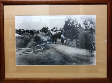
Photograph (Framed), Greensborough bridge, 1902-1925
... Greensborough Historical Society 34A Glenauburn Road Lower Plenty Lower Plenty melbourne View of bridge over Plenty River looking south up Main Street Greensborough pioneer reserve greensborough main street bridge Valley Picture Framing, corner Church and Grimshaw Streets Black and white photograph, mounted in wooden frame with glass Greensborough bridge Photograph (Framed) ...View of bridge over Plenty River looking south up Main Street GreensboroughBlack and white photograph, mounted in wooden frame with glassValley Picture Framing, corner Church and Grimshaw Streetspioneer reserve greensborough, main street bridge