Showing 9 items matching "vegetation assessment"
-
 University of Melbourne, Burnley Campus Archives
Document, Rotary Park St. Kilda, 1996
... ...vegetation assessment...Landscape and Vegetation Assessment - assignment by Jenny Boyer...University of Melbourne, Burnley Campus Archives 500 Yarra Boulevard Richmond melbourne rotary park st kilda landscape vegetation assessment jenny boyer Landscape and Vegetation Assessment - assignment by Jenny Boyer Rotary Park St. ...Landscape and Vegetation Assessment - assignment by Jenny Boyerrotary park, st kilda, landscape, vegetation assessment, jenny boyer -
 University of Melbourne, Burnley Campus Archives
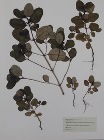
Plant specimen - Pressed Plant Material, Jenny Boyer, Pressed plants, 1996
... Portfolio of pressed plants for Landscape and Vegetation assessment. By Jenny Boyer dated October 1996 for Plant Materials - 2, taken by Michael Looker. ...University of Melbourne Burnley College Plant Materials 2 - Michael Looker Landscape and Vegetation Assessment ROTARY PARK ST KILDA Jenny Boyer October 1996...University of Melbourne, Burnley Campus Archives 500 Yarra Boulevard Richmond melbourne Portfolio of pressed plants for Landscape and Vegetation assessment. By Jenny Boyer dated October 1996 for Plant Materials - 2, taken by Michael Looker. jenny boyer michael looker Landscape and vegetation assessement pressed plants plant collection artifact University of Melbourne Burnley College Plant Materials 2 - Michael Looker Landscape and Vegetation Assessment ROTARY PARK ST KILDA Jenny Boyer October 1996 Handmade heavy cardboard portfolio containing 8 separate sheets of pressed plants protected by tissue paper. ...Portfolio of pressed plants for Landscape and Vegetation assessment. By Jenny Boyer dated October 1996 for Plant Materials - 2, taken by Michael Looker. Handmade heavy cardboard portfolio containing 8 separate sheets of pressed plants protected by tissue paper. For assessment for subject Plant Materials 2, taught by Michael Looker. By Jenny Boyer dated October 1996 University of Melbourne Burnley College Plant Materials 2 - Michael Looker Landscape and Vegetation Assessment ROTARY PARK ST KILDA Jenny Boyer October 1996jenny boyer, michael looker, landscape and vegetation assessement, pressed plants, plant collection, artifact -
 Federation University Historical Collection
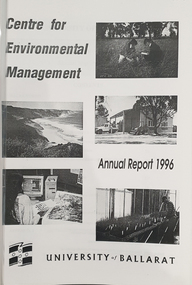
Booklet, University of Ballarat Centre for Environmental Management, 1996
... ...native vegetation assessment...The University will be working with the lessees to develop the historic Telegraph Station as a dual purpose facility for interpretation and research." university of ballarat centre for environmental management martin westbrooke richard mcewan mal weston john miller nanya telegraph station, cape otway cape otway lighthouse station cape otway telegraph station field resaerch stations s. hadden peter dahlhaus r.j. macewan pat prevett native vegetation assessment fauna management pest plants and animal research soil and water assessment conservation reserve management paul ryan richard macewan Black and white cover with clear plastic sheet. ...The Centre for Environmental Management as established in July 1995 as a strategic development initiative to consolidate the University's position as a centre for industry linked environmenttal teaching, resarech and consultancy. Page 19 "SPECIAL INITIATIVES Establishment of field Research Stations Two areas of concentration of research effort for the Centre are the Otways in the south western Victoria and the Scotia Country in the rangelands of NSW. In both these areas it is essential that ther be a secure accomodation abase for research students. In the former case there is a need for a sheltered base to enable year round field work in cold wet conditions and in the latter a base with a reliable water supply and the facilities to allow field work in very hot dry conditions which prevail from much of the year. It has been an ibjective of the Centre to establish field stations at these two sites and considerable progress has been made through the year. (i) Nanya Field Station in the Scotial Country Through the generosity of the owner, Mr Rob Taylor, an unused homestead on Nanya Station was made available to the Centre. Largely through voluntary labour during research field trips during the year this previously derelict homestead has been restored to functionality and now has facilities for up to 20 research workers with a reliable water supply, cooking, washing, and refrigeration facilities. (ii) Cape Otway Resaerch Centre Negotiations have continued through the year with the potential lessees of the Cape Otway Lighthouse Precinct with the support of the Vice Chancellor and other potential user groups within the University these have reached a successful outcome. The University will be working with the lessees to develop the historic Telegraph Station as a dual purpose facility for interpretation and research." Black and white cover with clear plastic sheet. university of ballarat, centre for environmental management, martin westbrooke, richard mcewan, mal weston, john miller, nanya, telegraph station, cape otway, cape otway lighthouse station, cape otway telegraph station, field resaerch stations, s. hadden, peter dahlhaus, r.j. macewan, pat prevett, native vegetation assessment, fauna management, pest plants and animal research, soil and water assessment, conservation reserve management, paul ryan, richard macewan -
 Greensborough Historical Society
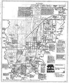
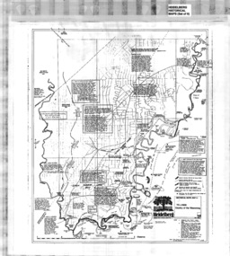
Map, Heidelberg: Historic River Landscape Assessment. Historical Maps. Map B 1838-1851, "The Distinctly aristocratic locality", 1985c
... vegetation and properties, with contemporary notes on landowners, descriptions and comments on the land and its development. Bounded by Shire of Diamond Valley to the North, Darebin Creek to the West and Plenty River to the East heidelberg heidelberg - maps Black and white sketch map on white paper Heidelberg: Historic River Landscape Assessment. ...Geographical area of around 35 sq. kilometres marked with physical features such as major roads, rivers, vegetation and properties, with contemporary notes on landowners, descriptions and comments on the land and its development. Bounded by Shire of Diamond Valley to the North, Darebin Creek to the West and Plenty River to the EastBlack and white sketch map on white paperheidelberg, heidelberg - maps -
 Greensborough Historical Society
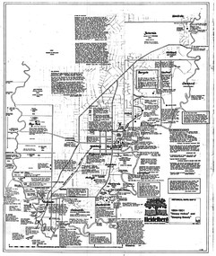
Map, Heidelberg. Historic River Landscape Assessment. Historical maps: Map C 1851-1863. "The Garden of the colony", 1985c
... vegetation and properties, with locations and notes of the increasing number of farms, gardens orchards and vineyards which had become established in addition to pastoral runs. Bounded by Shire of Diamond Valley to the North, Darebin Creek to the West and Plenty River to the East. heidelberg heidelberg - maps Black and white sketch map on white paper Heidelberg. Historic River Landscape Assessment ...Geographical area of around 35 sq. kilometres marked with physical features such as major roads, vegetation and properties, with locations and notes of the increasing number of farms, gardens orchards and vineyards which had become established in addition to pastoral runs. Bounded by Shire of Diamond Valley to the North, Darebin Creek to the West and Plenty River to the East.Black and white sketch map on white paperheidelberg, heidelberg - maps -
 Greensborough Historical Society
Map, Heidelberg: Historic River Landscape Assessment. Historical maps. Map D 1864 -1901 "Sleepy Hollow" and "Sleeping beauty", 1985c
... vegetation and properties, with locations and notes on the increasing number of farms, orchards and vineyards that had been developed in addition to pastoral runs. Bounded by Shire of Diamond Valley to the North, Darebin Creek to the West, and Plenty River to the East. heidelberg heidelberg - maps Black and white sketch on white paper. Second copy 600 x 430 cm printed in black on semi-opaque paper Heidelberg: Historic River Landscape Assessment ...Geographical area of c. 35 sq. kilometres marked with physical features such as major roads, rivers, vegetation and properties, with locations and notes on the increasing number of farms, orchards and vineyards that had been developed in addition to pastoral runs. Bounded by Shire of Diamond Valley to the North, Darebin Creek to the West, and Plenty River to the East.Black and white sketch on white paper. Second copy 600 x 430 cm printed in black on semi-opaque paperheidelberg, heidelberg - maps -
 Greensborough Historical Society
Poster - Map, Heidelberg: Historic River Landscape Assessment, Historical Maps. Map A To 1838. Country of the Wawarang, 1985c
... vegetation and properties, with contemporary notes on landowners, descriptions and comments on the land and its development. Bounded by Shire of Diamond Valley to the North, Darebin Creek to the West and Plenty River to the East. heidelberg heidelberg - maps Black an white sketch map on white paper Heidelberg: Historic River Landscape Assessment, Historical Maps. ...Geographical area of around 35 sq. kilometres marked with physical features such as major roads, rivers, vegetation and properties, with contemporary notes on landowners, descriptions and comments on the land and its development. Bounded by Shire of Diamond Valley to the North, Darebin Creek to the West and Plenty River to the East.Black an white sketch map on white paperheidelberg, heidelberg - maps -
Whitehorse Historical Society Inc.
Pamphlet, Eastern freeway extension, 1/02/2000 12:00:00 AM
... assessment. Supplement no 13 : mapping of trees and native vegetation within the Deep Creek Road realignment [by] Botanicus Australia Pty Ltd for VicRoads....assessment. Supplement no 13 : mapping of trees and native vegetation within the Deep Creek Road realignment [by] Botanicus Australia Pty Ltd for VicRoads. ...Eastern Freeway extension Between Springvale Road and Ringwood: flora and fauna assessment.Eastern Freeway extension Between Springvale Road and Ringwood: flora and fauna assessment. Supplement no 13 : mapping of trees and native vegetation within the Deep Creek Road realignment [by] Botanicus Australia Pty Ltd for VicRoads.Eastern Freeway extension Between Springvale Road and Ringwood: flora and fauna assessment. eastern freeway extension, native plants, wild life, vicroads, deep creek road, mitcham -
Bendigo Historical Society Inc.
Document - Fortuna - Health, Reports and Risk Assessments of the Site, 2008
... vegetation regrowth. Heritage investigations note that the uniqueness of Fortuna lies in the mixture of architectural styles of the Villa. The relationship between mining and domestic areas and the. close proximity of the two is considered rare to Australian domestic building of that time. bendigo fortuna george lansell Fortuna - Health, Reports and Risk Assessments of the Site This item contains the following documents: 11217.75a Fortuna Defense Site - Health Risk Assessment Final Report - 50 pages and appendices A to M - Contact the BHS for details 11217.75b Fortuna Defense Site - Structural inspection and report on various buildings, Department of Defence, Fortuna Site, 30 Chum Street Bendigo - Contact the BHS for details 11217.75c Fortuna Defense Site - Department of Defence Summary Report on Property Disposals Bendigo - Contact the BHS for details 11217.75d Fortuna Defense Site - Department of Defence Report on unexploded ordnance - Contact the BHS for details 11217.75e Fortuna Defense Site - Department of Defence Phase 1 Summary Report on Property Disposals Bendigo - Contact the BHS for details 11217.75f Fortuna Defense Site - Health Risk Assessment Final Report - 50 pages and appendices A to M - Contact the BHS for details 11217.75g Fortuna Defense Site - Environmental Site Assessment - Contact the BHS for details Document Fortuna - Health, Reports and Risk Assessments of the Site ...Theodore Ballerstedt originally purchased the Fortuna site from the Crown in 1857. The firstimprovements at Fortuna were undertaken by the Ballerstedt family and consisted of a small mill and house. At the peak of the mining era (c.1860s) Fortuna was central to the deep alluvial gold mining operations of Bendigo. In 1871 Theodore Ballerstedt sold the house, mine and associated works to George Lansell 'The Quartz King'. During his time at Fortuna, Lansell owned 13 mines and directed a further 73 in Bendigo. The primary building on the site is the Fortuna Villa. With the wealth Lansell generated from gold mining he funded the continuous expansion of the Villa and surrounding grounds. The Villa is built in a number of architectural styles, namely Victorian Italianate and Victorian Free Classical, with Federation influences. The surrounding landscape featured up to seven decorative lakes in the early 1870s, including one larger lake which still remains today. The former lakes were originally used as disposal points for tailings produced in the gold processing activities at the site. Fortuna was occupied by the Department of Defence from 1942 and was compulsorily acquired for Army use in 1957. Since that time Fortuna has been occupied by the Army and other various Defence organisations. During Defence's ownership, additional buildings were constructed and existing buildings were modified for re-use. In 1992 Defence purchased the adjoining undeveloped property, commonly known as the Bush Block. This parcel of land adjoins the main Fortuna landholding. It is approximately 0.8 hectares in size and is predominately covered in vegetation regrowth. Heritage investigations note that the uniqueness of Fortuna lies in the mixture of architectural styles of the Villa. The relationship between mining and domestic areas and the. close proximity of the two is considered rare to Australian domestic building of that time.Fortuna - Health, Reports and Risk Assessments of the Site This item contains the following documents: 11217.75a Fortuna Defense Site - Health Risk Assessment Final Report - 50 pages and appendices A to M - Contact the BHS for details 11217.75b Fortuna Defense Site - Structural inspection and report on various buildings, Department of Defence, Fortuna Site, 30 Chum Street Bendigo - Contact the BHS for details 11217.75c Fortuna Defense Site - Department of Defence Summary Report on Property Disposals Bendigo - Contact the BHS for details 11217.75d Fortuna Defense Site - Department of Defence Report on unexploded ordnance - Contact the BHS for details 11217.75e Fortuna Defense Site - Department of Defence Phase 1 Summary Report on Property Disposals Bendigo - Contact the BHS for details 11217.75f Fortuna Defense Site - Health Risk Assessment Final Report - 50 pages and appendices A to M - Contact the BHS for details 11217.75g Fortuna Defense Site - Environmental Site Assessment - Contact the BHS for detailsnon-fictionbendigo, fortuna, george lansell