Showing 146 items matching "victoria. department of lands and survey"
-
 Greensborough Historical Society
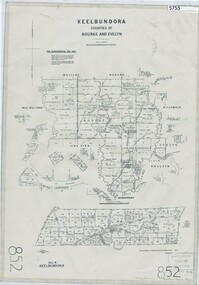
Map, Keelbundora. Counties of Bourke and Evelyn, 1950_11
... Victoria. Department of Lands and Survey...Counties of Bourke and Evelyn Map Victoria. Department of Lands and Survey ...Covers area bounded by Merri Creek, Yarra River, Plenty River and Crown Portions 24 to 28, with section including Maroondah Aqueduct and Darebin Creek.Photocopy of digitised mapkeelbundora (parish) -
 Eltham District Historical Society Inc
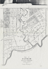
Document - Map, Victoria. Department of Crown Lands and Survey, Town of Eltham, Parish of Nillumbik, County of Evelyn, 2 October 1929
... Victoria. Department of Crown Lands and Survey...Schultz William Thomas Eltham Primary School Eltham State School Eltham State School No. 209 Quarry Reserve A3 size photocopy Town of Eltham, Parish of Nillumbik, County of Evelyn Document Map Victoria. Department of Crown Lands and Survey ...Township of Eltham, Parish of Nillumbik, County of Evelyn / lithographed at the Department of Lands & Survey Melbourne 5th June 1888, amended 2 October 1929 This amendment from the 1888 original shows the reserve for the the State School marked as permanent with dimensions added to Main Road and block frontages along Main Road between Mount Pleasant Road and Dalton Street and Metery Road Possibly photocopied from a copy held at PROV by Harry Gilham whilst resaerching Eltham Primary School history in 1995.a. armstrong, a. lavard, arthur c. allan, arthur c. allen, b. bowatere, baxter street, benjamin oliver wallis, bolton steet, c. souter, c.s. hain, cemetery reserve, charles brown, charles newman, charles symons wingrove, christopher caldwell, church of england, d. anderson, dalton street, david ballard, e. james, e.m. peck, edward dumaresq, eltham town, ely street, f.e. falkiner, f.m. peck, falkiner street, flint street, g. buckingham, g. drabble, george stebbing, godalmin street, h. peck, h.c.whess, h.h. farquharson, h.j. bews, henry stooke, j. goer, j. mcdonald, j. mclaren, j. roberts, j.b. knagers, james irish, jane bailey (nee matthews), john l. smith, john mason, john scott, john smith, joseph stevenson, joseph verse, k. wingrove, k.e. dunstan, kerby street, kirby street, location tbd, m. coman, map, michael o'shea, o.b. mccutcheon, p. & g. tumbull, p.k. mccaughan, p.p. cotter, porter street, pound reserve, robert hepburn, roman catholic church, s. evans, samuel dagley, samuel phillips, samuel ramsden, t. upton, t. watkins, t.a. stark, t.c.b. batt, t.p. cross, thomas grant, thornton street, w. adam, w. blain, w. long, w. watkins, w.f. ford, w.h. hull, w.r. belcher, w.t. schultz, william thomas, eltham primary school, eltham state school, eltham state school no. 209, quarry reserve -
 Greensborough Historical Society
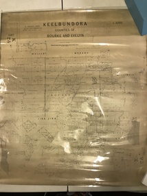
Map, Victoria. Department of Crown Lands and Survey, Keelbundoora; Counties of Bourke and Evelyn, 1950c
... Victoria. Department of Crown Lands and Survey...Keelbundoora; Counties of Bourke and Evelyn Map Victoria. Department of Crown Lands and Survey ...Map of the Victorian counties of Bourke and Evelyn showing parish boundaries and land ownership.Show the original landholders for this area.Map on light brown parchment, covered in plastic."L.5305" and "3462" -
 Bendigo Historical Society Inc.
Map - BENDIGO, 1916
... Smaller map of State of Victoria. Lithographed at the Department of Lands and Survey, Melbourne. 1916. ...Smaller map of State of Victoria. Lithographed at the Department of Lands and Survey, Melbourne. 1916. ...Map. Bendigo, Gunbower, Gladstone, Talbot, Dalhousie, Rodney, Jarklan, Calivil, Hayanmi, Mitiamo, Wanurp, Pannoobamawm, Bamawm, Millewa, Ballendella, Janiember West, Janiember East, Pompapiel, Talambe, Dingee, Milloo, Pannoomilloo, Rochester West, Yarrayne, Salisbury, Yallook, Tandarra, Kamarooka, Warragamba, Diggorra, Minto, Bridgewater, Yarraberb, Neilborough, Whirrakee, Egerton, Elmore, Nolan, Goornong, Bagshot, Huntly, Derby, Leichardt, Nerring, Tarnagulla, Woodstock, Marong, Sandhurst, Wellsford, Bendigo, Axedale, Strathfieldsaye, Eppalock, Kimbolton, Lyell, Sedgwick, Mandurang, Lockwood, Ravenswood, Shelbourne, Laanecoorie. Price 3/-. Smaller map of State of Victoria. Lithographed at the Department of Lands and Survey, Melbourne. 1916. Scale : Two miles to one inch. Map was in book form. (number 62 in map cupboard 1)map, bendigo, bendigo -
 Bendigo Military Museum
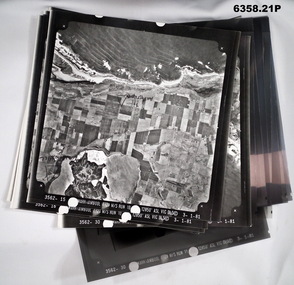
Photograph - Aerial Photography - Mohogany Ship Search Warrnambool Victoria, Victorian Lands Department, 3.1.1981
... Bendigo Military Museum 37 - 39 Pall Mall Bendigo goldfields These Victorian Lands Dept Aerial Photographs were acquired by the Army Survey Regiment to help locate a Mohogany Ship wreck near Warrnambool Victoria as part of a unit Regimental Training Exercise Royal Australian Survey Corps RASvy Fortuna Army Survey Regiment Army Svy Regt ASR Seven Aerial photographic Prints and Film Negatives and positives of the same images. Images are Numbered 3562- 15,16,17,18,19, 29 and 30. Aerial Photography - Mohogany Ship Search Warrnambool Victoria Photograph Aerial Photography - Mohogany Ship Search Warrnambool Victoria Victorian Lands Department ...These Victorian Lands Dept Aerial Photographs were acquired by the Army Survey Regiment to help locate a Mohogany Ship wreck near Warrnambool Victoria as part of a unit Regimental Training ExerciseSeven Aerial photographic Prints and Film Negatives and positives of the same images. Images are Numbered 3562- 15,16,17,18,19, 29 and 30.royal australian survey corps, rasvy, fortuna, army survey regiment, army svy regt, asr -
 Emerald Museum & Nobelius Heritage Park
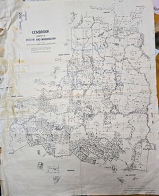
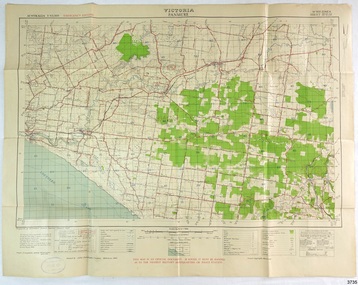
Map - Land Holding map issued by Lands Council Victoria - area south of Emerald township (now mostly under Cardinia Reservoir), Gembrook, Counties of Evelyn & Mornington land holding map 1967, c1967
... JOHNSON (22.8.68)/By Authority AC Brooks, Government Printer, Melbourne/Drawn and reproduced at the Department of Lands and Survey, Melbourne/Price $1.00 per sheet Image of land holdings map for area south of Emerald township in the counties of Evelyn & Mornington, Gembrook Gembrook, Counties of Evelyn & Mornington land holding map 1967 Map Land Holding map issued by Lands Council Victoria - area south of Emerald township (now mostly under Cardinia Reservoir) ...land holdings map showing holdings south of the main township of Emerald, much or which is now under the Cardinia ReservoirImage of land holdings map for area south of Emerald township in the counties of Evelyn & Mornington, GembrookGembrook G206 Sheet/Gembrook counties of Evelyn and Mornington/Compared with originals H.R. JOHNSON (22.8.68)/By Authority AC Brooks, Government Printer, Melbourne/Drawn and reproduced at the Department of Lands and Survey, Melbourne/Price $1.00 per sheet -
Federation University Historical Collection
Document, Zelda Martin, Central Victorian Goldmining towns - Boom Towns or Ghost Towns?, c1996
... Victoria After Its Separation from New South Wales. Hand written notations: 'roads, markets, and local government 1855 on' ;'opportunity of squatters in parliament' and 'opportunities of matters in parliament p33' * Notes on the Establishment of Surveyor General's Department 1851and Commissioner of Crown Lands and Survey...Victoria After Its Separation from New South Wales. Hand written notations: 'roads, markets, and local government 1855 on' ;'opportunity of squatters in parliament' and 'opportunities of matters in parliament p33' * Notes on the Establishment of Surveyor General's Department 1851and Commissioner of Crown Lands and Survey ...Zelda Martin was a PhD candidate at the University of Melbourne.[.1] 4th item in light blue display book titled Research Approach/Overview of Chapters/Confirmation of Canditure/Chapters1,2,3&4 of proposed thesis. *Twenty-seven page article on Victorian goldfields towns titled: Central Victorian Goldmining Towns - Boom Towns or Ghost Towns. The article was written during the author's PhD study. It outlines the context methodology, and resources and the chapters of the proposed thesis: (1) Central Victorian Goldmining Towns - The Context (2) Contemporary Views of the Factors Necessary for Town Growth (3) Outward Manifestations of Town Growth (4) The Trappings of Government (5-9) The Main Towns and Their Hinterland. [.2] 5th item in Light Blue display book as above item. *Chapter 1 of proposed thesis titled 'Pick, Shovel and Tin Dish Mining.' Covers in Section A: Central Victoria - Pre 1851: Aborigines in Central Victoria, Squatters, and Government. Section B: The years 1851-1854: The Early Gold Rushes, Government Reaction, Township Surveys, Legislation, Town Development, Local Government and Early Settlement. [.3] 6th item in Light Blue display book as above item. *2A of proposed thesis titled 'Contemporary Views of the Factors Necessary for Town Growth'. Similar information to Chapter 1 plus extra re towns and maps. Sections: Introduction, Context of Place - Geographical Towns Listed, The Context of Time - Pre1851 Aborigines, Governance of Port Phillip, The Squatters, The Villages of Central Victorian Highlands, Conclusion, Condensed Version of Chapter2B. [.4] 7th item in Light Blue display book as above item. *Chapter2B of proposed thesis. Sections: Area of Research, Schools, Banks, Newspapers, Progress Association, Town Development - Sandhurst (Bendigo), Ballarat, Castlemaine,, Maryborough, Ararat and Stawell. [.5] 8th item in Light Blue display book as above item. *Chapter 3 of proposed thesis titled 'Outward Manifestations of Town Growth'. Sections: Introduction, Contemporary Writing, Educationalists, The Bankers, The Townsfolk, Current Theory, General Theories of Urban Development, and Conclusion. [.6] 9th item in Light Blue display book as above item. *Chapter 4 of proposed thesis titled 'Trappings of Government' Sections: Introduction, Early Government Attitudes to Mining and Town Development, Law and Order, Township Surveys, Legislation, Local Government, Transport and Communication, The People and Lobbyists. [.7] 10th item in Light Blue display book as above item. *'The Rise and Fall of Central Victorian Goldmining Towns'. Includes a map showing main Goldfields, a table showing towns and villages at two points in time - 1857 and 1871; a Bibliography of Primary and Secondary Sources. [.8] Resource No1. Black display book titled Local Towns 1 : Alma: *Brief history *Directory *Maps Amphitheatre / Mountain Hut: *Brief History Post Office Directory Ararat: *Brief History *Post Office Directory 1869 - Alphabetical Listing by Occupation *Ararat - Prominent Citizens of 1858 *Langi-Morgala Museum Avoca: *Brief History *Excerpts from 'Avoca The Early Years', Margery and Betty Beavis; pg1 - Beginnings; pg11 - The Midas Touch; pg25 - Local Gold Escorts; pg27 - A Town is Born; pg51- The Administration of Justice; pg53 - The Ways of the Law; pg61 - News of the Day; pg65 - A Time to Play; pg72 - Land Ownership *Post Office Directory (Bailliere's) 1869 *Tourism Map and Information of area *Historic Avoca - A 5.5km Tour *Avoca & the Pyrenees Region - information pamphlet Ballarat: *Early History of Ballarat - Ballarat Historical Society, Publication No.1: origin of the name; Ballaarat - the Beginning; Fabulous Yields from the Ballaarat Goldfield; *Streetscape Lydiard Street. *Hand drawn map showing Leigh River, Old Portland Bay Road, plaque on road to Colac; etc. *Newspaper article re 'The Theatre Royal' ( which stood in the vicinity of the current Owen Williams store) - 'The News'15/04/1998 *Article - 'Ballarat's Mechanics' Institute Lives On' Ballarat Courier, 14/09/1985 *Article - Standing the Test of Time' The News 17/11/1993 re The Mechanics Institute & picture of the Reading Room *'Ballarat a Study of a City, Phyllis Reichl, pub. Nelson, 1968; no.3 place, time and people field studies series *Investigator Vol.33 No.2, 1998 Geelong Historical Society. Article on pg75 describes Ballarat in 1861 *Folded poster - 'Ballarat 100' a history of telegraph communication, pub. Telecom. Beaufort (Fiery Creek): *Brief history *Post Office Directory [.9] Resource No.2 Black Folder Titled Towns cont.No2 Bendigo (Sandhurst): *'Family & Local History at the Bendigo Library - 1851-2001 150 years of gold'. *Bendigo Government Camp in 1853 illustration; key to sketch and names of Government officers stationed there *Excerpts from 'Bendigo and Vicinity' Adolph Haman *The Bendigo Goldfield Registry - pgs 1-7 Introduction *Excerpt: 'Breaking the Grip' *Excerpt: The Most Go-Ahead Place *Excerpts from 'History of Bendigo' - anti license agitation; laying out of town; proposed railway; gold calls and dividends; the Sandhurst Municipality; journalism *Bibliography Blackwood: *Excerpts from 'Aspects of Early Blackwood - The Goldfield, the Landmarks, the Pioneers' Alan J Buckingham and Margaret F Hitchcock, JG Publishing,1980 Buninyong: *A Brief History *Investigator Vol1 No.2 Feb 1966 Geelong Historical Society. Pg3 - Article re gold escort route - Mt Alexander to Adelaide - (see a simple monument on the Western Highway a few miles out of Horsham. Pg 15 - Ballarat Excursion - re the finding of gold. *Three articles published by Buninyong and District Historical Society Inc: (Magpie Exploration; Finding Gold In The Green Hills; Magpie Exploration; Burnt Bridge to Cargarie to Mt Mercer) *Copies of newspaper articles/items *Buninyong Street Directory Carisbrook: *In the Beginning There Was Carisbrook *The History of the Carisbrook Racecourse Carngham / Snake Valley: *Brief History *Directory Castlemaine: *Directory 1865-1866 - Alphabetical and Street *Poster - Castlemaine A Contemporary Guide "The Great Centre" 1866 - A Contemporary Guide to the Fascinating Past *Pamphlet - Castlemaine District Community Hospital *Map - Castlemaine, Maldon & Surrounding Districts *Map and Information - The Dry Diggings Track - a 55kl walk among historic goldfields relics ( Castlemaine Fryerstown Vaughan Mt Franklin Hepburn Daylesford) *Postcard - Former Court House *Directory 1867 - Alphabetical, Trade [.10] Resource No.3 Grey folder Titled Towns 3 Creswick to Maryborough Creswick: *Brief History *Booklet - "Creswick Cemetery Walk" *Booklet - The Buried Rivers of Gold Heritage Trail Creswick *Creswick Historical Museum Information Sheet *Chronological History of Creswick *Alphabetical Directory of the Borough of Creswick *Creswick's Creek Directory 1856 *Historic Creswick Walking Tour *A Brief Account of the Schools of Creswick - Past and Present *100 Years of Railway Travel in Creswick *The Berry Deep Leads *The Spence Home at Jackass Gully in the Creswick State Forest ( William Guthrie Spence - Pioneer) *The New Australian Mine and the 1882 Disaster *Creswick District News, Issue 7, July August 1999 *The Creswick Miners Walk - Information and Map *Maps Chewton: *Brief History *Directory Clunes: *Brief History *Clunes Street Directory Daylesford: *Brief History *Notable Bushfires in Daylesford District Over More Than a Century - "Black Thursday" 1851; 1862; 1899; the Disastrous Hepburn Fire of 1906; 1939; 1944; 1969. *Post Office Directory -Daylesford and Hepburn Dunolly / Inkerman: *Brief History *Directory *Pamphlet - Goldfields Historical Museum *Pamphlet - Historic Dunolly - Victoria's Best Kept Secret *Map of Gold Workings at Dunolly Area - showing where the main gold rushes occurred *Brief History - Inglewood *Directory - Inglewood - Name Occupation, Dwelling Kingower: *Brief History *Directory - Name / Ocupation / Dwelling Linton / Happy Valley / Piggoreet: *Brief History *Directory - Lintons McIvor: *"A History of the Shire and the Township of Heathcote" by J.O. Randell Majorca: *Brief History *Official Post Office Directory 1869 - Name / Occupation/ Address Maldon (Tarrangower): *Brief History Part 1 *Brief History Part 2 *Post Office Directory *List - Alphabetical Order by Names plus Business and Trade (Tarrangower Times Oct/1858) *List - Alphabetical Order by Trade plus Name and Business *Directory - Name / Occupation / Dwelling Maryborough: *Worsley Cottage - built by Arthur Worsley, a contractor in stonework in 1894 [.11] Resource No. 4 Blue Display Book titled Towns 4 Moliagul to Stawell Moliagul: *Brief History *Moligul Legislative Assembly (Voting?) List - Names and Occupations *Moliagul Victorian Post Office Directory 1868 - Name / Ocupation / Address / Comments *"The Welcome Stranger" gold nugget *The Sunday School *The Welcome Stranger Discovery Walk - information and map Moonambel (Mountain Creek) Redbank *Brief History *List of names extracted from advertisments of the Pioneer and Mountain Creek Advertiser 16/02/1861. *Bailliere's Directory 1869 - Alphabetical List of Name / Occupation / Place St Arnaud: *Brief History Sebastapol: *Brief History *Directory 1869 - Alphabetical by Name; plus occupation and address. Browns and Scarsdale: *Brief History *Browns Street Directory - Name and Occupation Smythesdale: *Brief Description *Smythesdale Street Directory -Name and Occupation Stawell (Pleasant Creek) *Brief History *Victorian Official Post Office Directory - Name /Occupation / Dwelling *Chronology - 1841-1920 *Production of gold statistics - 1879 - 1900 *Big Hill *Extracts from "The Golden Years of Stawell". Chapt 1 - Stawell's Coming Out. Capt. 2 - The Gold Rush. Caapt.3 - Cradle of Democracy. Chapt.4 - The Reefs Becomes Stawell. Chapt. 5 - Rushing In. Chapt.6 - The Pioneers. Chapt 7 - The Decade of Optimism. [.12] Resource No. 5: Blue Display Book titled 'Towns Steiglitz to the The Golden Triangle. Steiglitz: Brief History Victorian Post Office Directory 1869 *Map of Steiglitz *List of maps relevant to Steiglitz history *Information 6 tables of data from "Reports of Mining Surveyors Talbot (Back Creek) Brief History Taradale: Post office Directory 1869 - Name/Occupation/Street. Also list in alphabetical order by Occupation Taradale *Chronological Reference to Taradale Mines *Water - The Coliban System of Waterworks *Joseph Brady *The Syphon Tarnagulla (Sandy Creek) *Brief History *Tarnagulla Businessmen Cameos to give depth to advertisments in 'The Tarnagulla Courier' various issues 1864-1871 *Directory - Name/Occupation /Address *List - Name/Business/Trade Wedderburn (Koorong) *Brief History *List - Name/Occupation The Golden Triangle: *The Early Rushes - Wedderburn / Moliagul / Sandy Creek - Tarnagulla / Jones Creek - Waanyarra / Kingower / Dunolly - Goldsborough / Inglweood *Census of 1857 - Population / Occupations *1858-1871 - A Time of Consolidation- Wedderburn / Moliagul / Sandy Creek- Tarnagulla / Arnold *Census 1871 - Population *Information gleaned from the census data - Demographics / Population / Occupations / marital / Birthplace / Religion / Literacy/ Occupation and Housing Cameos *Graphs - Birthplace of settlers /Male-Female Ratio / Married males / Children under 15 as Percentage of Population / Religion *Census 1857 - Statistical data *Maps *Bibliography [.13] Resource No. 6 - Black Display Book Information and Research in Central Victoria including: *Banking - Research from ANZ Bank Archives *Institutions - also includes articles listed from the Ballarat Times Newspaper *Australian mining History Association - A.M.H.A. Bibliography *Australia's Mining History * Bibliography - Land Surveys Victoria - *1853 Administration (Statistics and Other) includes: schools / ministers of religion / police / military / local administration / licences for sale of spirits / distances between various Victorian gold fields. * Victoria Government Gazette (Copy) - N0. 116, 12/12/1854 includes: Gold Felds Commission of Enquiry & No. 85, 15/09/1854 - Addresses presented to the Lieutenant Governor (Sir Charles Hotham) during his tour through the Gold Fields of Victoria,1854. Addresses on behalf of : the people of Bendigo; Members of the Church of England, Bendigo; Members of the Wesleyan Church on the Bendigo Gold Fields; Bendigo Gold District General Hospital; the Bendigo Prospecting Association; Committee of the Bendigo Local Exhibition; Bendigo District Medical Association; Coloured Americans Resident at Bendigo; German Inhabitants of Bendigo; Landowners, Inhabitants, and Miners of Castlemaine; Inhabitants of Forest Creek; Inhabitants of Heathcote and Gold Miners of McIvor; Residents and landholders of the District of Bacchus Marsh; Inhabitants of Kilmore and Vicinity. *Gold Fields Correspondence 1853: letter from Lieutenant Colonel Valiant, (Officer commanding the Troops in Victoria) to the Lieutenant Governor re threatened disturbance at Sandhurst (Bendigo) regarding the Gold License Fee. * Extracts from a book "Victoria" re Gold Fields Commission of Enquiry involving mainly Ballarat and Castlemaine and a chapter titled 'A Tour to the Victorian Gold-Fields' *Lists of central Victorian newspapers - listed by date published 1851to 1874; by first date available to State Library. *A list of cities and towns showing County, population in 1861 &1871, and municipal status. [.14] Resource no.7. Black display book. *Reference: Papers presented to Parliament Victoria - 1859-1860 4 volumes - relevant sections copied. Contains information on Branches of Government. General / Finance / Gold / Gazette / Commission and Warrant / Statistic. *Gold Fields Act. In accordance with the Act the gold fields are divided into six districts - Ballaarat, Castlemaine , Sandhurst, Avoca, Ararat, and Beechworth.. Official staff in each gold district consists of a Resident Warden, Wardens, Wardens' Clerks, Bailiffs, Chinese Protectors, Chinese Interpreters, and Mining Surveyors. *Gold Receiver *Gaols *Police magistrates and Clerks of Petty Sessions, etc. *Field Branch *Immigration and Emigration Overland - Chinese - 1859 *Population on the Goldfields *The Geological Survey - The Government Geologist is assisited by staff from four branches - the office Branch; the Publishing Branch; the Field Branch and the Museum Branch. *Commission to Enquire Into Sludge dated 10/02/1859 (Some sections copied) - Report to the Honorable Chief Commissioner of Public Works, Melbourne re the mode of carrying the sludge from the puddling mills in Sandhurst without interfering with the drainage of the town and the roads in the neighbourhood. [.15] Resource No.8: Camel display book titled Resource No. 8. Aborigines *Lists of book titles - +"Readings in Victorian prehistory" +"The Aborigines of Port Phillip" +Aboriginal languages and clans" +"A History of the Port Phillip District" +"Langi Ghiran 1: Aboriginal Rock...." +"Koorie History: sources for aboriginal studies in the State Library of Victoria", ed. Tom Griffiths, Melb. Friends of the State Library, 1989 +"The Public Lands of Australia Felix"; settlement and land appraisal in Victoria1834-91 with special reference to the Western Plains", J.M.Powell, Melb. Oxford University Press 1970 +*Bibliography of the Victorian Aborigines' from the earliest manuscripts to 31st December 1970, Massoa, Aldo, Melb. Hawthorn Press, 1971 +"Aborigines in Colonial Victoria, 1836-1886", M.F. Christie, Sydney University Press, 1979 +"Urban and Industrial Australia: readings in Human Geography" ed J.M. Powell, Melb. Sorrett Pub. 1974 *Extracts: -Processes of Pioneer Settlement - The Squatting Occupation of Victoria, 1834-60. J.M. Powell -Areal Variations in the Class Structure of the Central-Place Hierarchy. P. Scott - Volume1 and Volume 2: Notes Relating to the Habits of the Natives of Other Parts of Australia and Tasmania. Compiled from various sources for the Government of Victoria by R Brough Smyth. John Curry, O'Neil, Melb. 1st pub. Melb. 1876. p31-45 - Numbers and Distribution of the Aborigines in Victoria -Victorian Aborigines 1835-1901 - A Resource Guide to the Holdings of the Public Record Office, Victoria; published by the Government Information Centre 1984. *History of the Aboriginal Artefacts Displayed in the Daylesford Museum. F. G. Powell (4 page pamphlet) *Letter to Zelda Martin from Peter Lovett, Cultural Officer, Ballarat & District Aboriginal Co- Operative, 05/02/1997 *Map: Ian Clarke Victorian Tribunal Boundary Map - Clans of Central Victoria. *Victorian Rock Art and Mythology - Article about Mount Langhi Ghiran and myths of the Tjapwarong people. *Two Aboriginal myths relating to the Grampians - 'The Monster Emu' / 'The Aquisition of Fire', by the Aborigines in the Grampians Areas *Article titled (chapter 8) Ballarat - information re camping sites in the region. Lake Wendouree / Lake Burrumbeet (includes a myth) / Mt Bunninyong / Lal Lal / Pitfield / Mount Elephant / Mount Egerton / Meredith / Lake Goldsmith / Lake Learmonth / Ercildoune *Notes on the Aborigines of the Wider Ballarat Region plus European names=Aboriginal names. John Morris 26/07/1995 *Role of Aborigines in Town Development in Central Victoria. Mentions Native Police Force est. in Port Phillip 1842 and Central Board for Aborigines est. 1860 *The Grave of King Billy. (Frank Wilson) Pamphlet. *Camping Places in Central and Northern Victoria. Article re Lake Burrumbeet site. *Programme for the Unveiling of Memorial Cairn for Edward Stone Parker 1802-1865. Note portrait not accurate. Accurate portrait is available in the book "A Successful Failure A Trilogy The Aborigines and Early Settlers", Edgar Morrison, Graffiti Publications, 2002. * Large envelope addressed to Mr G Netherway containing newspaper cuttings regarding the life of Edward Stone Parker, the unveiling of the Memorial Cairn as mentioned above, articles titled 'Episodes from Our Early Days' (Edgar Morrison, Yandoit)- The Black's School, A School At Last and The Final years. Also a typed page titled 'Historical Background to E.S.Parker's Career. Includes an interesting tale titled 'When the cat lay doggo' re laying power leads for the unveiling ceremony at the memorial site. [.16] green display folder titled 'Research Aids' *List of references to Commissioners' & W'ardens' Reports (formerly held at La Trobe Library Archives, now at Public Records Office [PRO]). Indicates town referred to / date of report / name of camp if different to town. * Archive information re Anglican Records *Movement around the Goldfields - Miners and Storekeepers - usefulness of newspapers in providing information - areas covered - Castlemaine, Maldon, Ararat, Stawell, Tarnagulla, Dunolly. *Port Phillip /Victoria Directories 1839/1867 - Chronological list of Directories included in this series. *"Notes on the History of Local Government in Victoria" A.W. Greig Melb. University Press 1925 - Photo-copied extract p5-p40. (Source - Deakin University Library) - Introduction by W.Harrison Moore. Section 1 - Development in New South Wales Before Separation. Section 2 - Development in Victoria After Its Separation from New South Wales. Hand written notations: 'roads, markets, and local government 1855 on' ;'opportunity of squatters in parliament' and 'opportunities of matters in parliament p33' * Notes on the Establishment of Surveyor General's Department 1851and Commissioner of Crown Lands and Survey. * Newspaper articles from The Argus, 1849, re the discovery of gold in the Pyrenees region. * Excerpt - a report on schools - A.B.Orlebar, Inspector; re the need for permanent school buildings rather than tents. *Excerpt from - 'Approaches to Urban History', Sean Glynn: The Case for Caution * Except from - 'The Urban Sprinkle', Weston Bate: Country Towns and Australian Regional History *Reference- 'The History of Land Tenure in the Colony of Victoria', John Quick. References the Haines Land Bill, land tenure and Land Leagues. [.17] Light blue envelope folder titled 'Birtchnell's Ballarat, etc. Directory 1862 *Contains various directories for Smythesdale, Buninyong, Clunes, Brown's and Creswick. [.18] Red envelope folder no.2 titled Victorian Gazetteer *Selected pages from 1869 Victorian Gazetteer on A4 paper (with a handwritten note questioning if some pages are from 1868 Victorian Gazetteer as appears to be different sizes - A3 pages.) Information includes locations and descriptions of towns, hotels, banks, communications and populations. (Does not include names, residences and occupations) [.19] Red Envelope folder titled Bailliere's Official Post Office Directory 1868 (or1869 or a mixture of both?) *Preface *Contains a selection of pages of towns highlighted in yellow in the the index *Work on this directory was commenced in 1867. *Information includes: Municipalities - mayors and councilors; lists of towns naming male inhabitants and their occupations. [.20]Yellow manila folder titled Post Grad Seminar Presentation 1996 *Gives some background to Zelda Martin's proposed thesis and why she chose the topic Gold Mining Towns Boom or Bust [.21] A3 display book - No. 1A * A list of 'Relevant Newspapers collected: The Tarrangower Times and Maldon Advertiser (first published 1858) Includes dates 1858-1867. The Mount Alexander Mail. Includes dates 1854-1866 The Tarnagulla Courier. Includes dates from1864-1871 Dunolly and Burnt Creek Express. Includes dates from 1862-1871 * Selection of newspaper pages from The Mount Alexander Mail 1854 to 1856, mostly showing advertisements for businesses and services provided to that community. [.22] A3 display book - No. 1B * Selection of newspaper pages from The Mount Alexander Mail 1857 to 1866, mostly showing advertisements for businesses and services provided to that community. [.23] A3 display book -No. 2 * Selection of newspaper pages from The Tarnagulla Courier 1864 to 1871, mostly showing advertisements for businesses and services provided to that community. [.24] A3 display book - No. 3 *Selection of newspaper pages from The Tarrangower Times (and Maldon and Newstead) Advertiser 1858 to1867, mostly showing advertisements for businesses and services provided to that community. [.25] A3 display book - No.4 * Selection of newspaper pages from The Dunolly and Burnt Creek Express; and The Dunolly and Betbetshire Express 1862 to 1871, mostly showing advertisements for businesses and services provided for that community. [.26] A3 display book - No.5 Includes: * Bryce Ross's Diggings Directory. Includes instructions for using this directory. This directory was used by "all persons having connexion or desiring to communicate with 'working parties, private friends, or Stores at the Diggings." As a directory for each area wwas completed it was published in each month's issue of Bonwick's "Digger's Magazine." Years c1852/1853. This Directory commences first at the head of Forest Creek. Includes a directory for Bendigo and Ballarat. Of interest at the end of the Bendigo and Ballarat directory is a list of the number of storekeepers, butchers, doctors, smiths, eating houses, lemonade sellers and chapels. * The Castlemaine Directory and Book of General Information Comprehending Glass's Model Calendar for the Two Years 1862 and1863. "zelda martin, victorian goldfield towns, bendigo, castlemaine, ballarat, maldon, stawell, ararat, maryborough, creswick, avoca, heathcote, banks, bank of australasia, union bank of australia, government camp, sandhurst, water supply, tarnagulla, talbot, back creek, mountain creek, police court, carisbrook, dunolly, thompson's foundry, charles clacy, anthony trollope, robert cecil, mount alexander, urbanisation, national schools, education, govenrment, industry, railway, transport, settlement, land settlement in central victoria, steiglitz, joseph brady, the new australian mine, berry deep leads, william guthrie spence, creswick state forest, arthur worsley, worsley cottage, the welcome stranger, moliagul, moonambel, redbank, st arnaud, sebastapol, brown's, scarsdale, clunes, chewton, daylesford, bushfires, inkerman, inglewood, kingower, lintons, happy valley, piggoreet, mcivor, majorca, tarrangower, taradale, the coliban system, the syphon, sandy creek, wedderburn, koorong, arnold, jones creek, waanyarra, the golden triangle, census 1857, blackwood, buninyong, durham lead, magpie, carngham, snake valley, alma, amherst, daisy hill, amphitheatre, mountain hut, beaufort, fiery creek, counties, population, gold fields commission of enquiry1854, william westgarth, gold license fee, lieutenant colonel valiant, administration of the victorian gold fields, commission to enquire into sludge 1859, e.s. parker, edward stone parker, edgar morrison, mount franklin protectorate, dja dja wurrung, memorial cairn, franklinford, mt franklin memorial cairn, jajowurrong, dja dja wurung, tjaowarong, wothowurong, assistant protectors, daylesford museum, buluk, rock art - grampians, aboriginal mythology - grampians, aborigines, first nations people, mount franklin, aboriginal artifacts, lake burrumbeet, native police force, central board of aborigines, yandoit, commissioners' reports, wardens' reports, port phillip/victoria directories 1839-1867, local government - victoria 1853/1854, surveyor general's department - 1850's, victorian schools 1850's, a.b.orlebar, haines land bill, william charles haines, wilson gray, land tenure, land leagues, victorian gazetteer, the tarrangower times and maldon advertiser - 1858-1867, the mount alexander mail 1854-1866, the tarnagulla courier 1864, dunolly and burnt creek express 1862-1871, bryce rose's diggings directory, the castlemaine directory 1862-1863 -
 Orbost & District Historical Society
survey sheet, circa 1870's
... Bruce A survey map - Sheet No 3 SnowyRiver Survey. This is a copy of the original survey. ...E.L. Bruce, born in Ireland on July 1,1854, came to Australia in 1854 and joined the Lands Department. He spent most of his service in Gippsland. The journey to Sale then was made by ship to Port Albert and thence on horseback. He began his service in Gippsland as assistant district surveyor and for the last 12 years before retirement he was district surveyor and land officer. His territory extended from the boundary of Victoria in east Gippsland down to Wilson's Promontory with his headquarters at sale.This map is a useful reference tool.A survey map - Sheet No 3 SnowyRiver Survey. This is a copy of the original survey. It shows the properties of W.J.T. Clarke - two in Orbost and one in Newmeralla (sic),. it has a faded, undecipherable red stamp in the bottom right corner.Gipps Land Rivers No 32B E.L. Brucesurvey bruce-e.l snowy-river-c19th -
Bendigo Historical Society Inc.
Map - VICTORIA, Circa 1926
... History House 11 Mackenzie Street Bendigo goldfields MAP Victoria counties Counties of Victoria Geographic features Map: Map showing Counties, including Railway lines and Geographic features. Compiled and engraved at the Department of Lands and Survey Melbourne, Revised October 1926 ( number 184 in Map Cupboard 1) Map VICTORIA ...Map: Map showing Counties, including Railway lines and Geographic features. Compiled and engraved at the Department of Lands and Survey Melbourne, Revised October 1926 ( number 184 in Map Cupboard 1)map, victoria, counties, counties of victoria, geographic features -
 Bendigo Historical Society Inc.
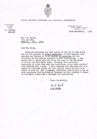
Document - PETER ELLIS COLLECTION: LETTER, 24th September, 1973
... Department of Crown Lands and Survey Victoria...History House 11 Mackenzie Street Bendigo goldfields COMMUNICATION Postal letters Peter Ellis Collection Department of Crown Lands and Survey Victoria Royal Botanic Gardens and National Herbarium P N Ellis Moon Mines Area A B Court Letter, dated 24th September, 1973, to Mr P N Ellis from A B Court of the Royal Botanic Gardens and National Herbarium. ...Letter, dated 24th September, 1973, to Mr P N Ellis from A B Court of the Royal Botanic Gardens and National Herbarium. In the A B Court thanks Mr Ellis for his letter and for the specimen of Acacia hakeoides. He was hoping it would turn out to be the same as the one known to him from the Moon Mines area. He had searched for this species? During the last several years but had been unable to find it. He suggest that if Mr Ellis or his associates find anything of interest in the locality it might be worthwhile forwarding a specimen for examination. Signed A B Court.communication, postal, letters, peter ellis collection, department of crown lands and survey victoria, royal botanic gardens and national herbarium, p n ellis, moon mines area, a b court -
Bendigo Historical Society Inc.
Map - YALLOOK : COUNTY OF BENDIGO, 30-1-28
... Drawn and reproduced at the Department of Lands and Survey, Melbourne, Victoria. 30-1-28. H.J. ...Drawn and reproduced at the Department of Lands and Survey, Melbourne, Victoria. 30-1-28. H.J. ...Map. Yallook, County of Bendigo, L4942, Talambe, Tandarra, Neilborough, Yarraberb, Salisbury, Pompapiel. Drawn and reproduced at the Department of Lands and Survey, Melbourne, Victoria. 30-1-28. H.J. Green, Govt. Printer, Melbourne. (number 18 in map cupboard 1)H.J. Green, Govt. Printer.map, bendigo, yallook -
Bendigo Historical Society Inc.
Map - NERRING : COUNTY OF BENDIGO, August 1952
... Drawn and Reproduced at the Department of Lands and Survey, Melbourne, Victoria, August 1952, Price 2/-.( number 409 in Map Cupboard 1)....Drawn and Reproduced at the Department of Lands and Survey, Melbourne, Victoria, August 1952, Price 2/-.( number 409 in Map Cupboard 1). ...Map. Nerring, County of Bendigo, Leichardt, Marong, Sandhurst, Huntly, Neilborough, Yarraberb. Drawn and Reproduced at the Department of Lands and Survey, Melbourne, Victoria, August 1952, Price 2/-.( number 409 in Map Cupboard 1).J.J. Gourley, Government Printer, Melbourne.bendigo, hospital -
Bendigo Historical Society Inc.
Map - NOLAN : COUNTY OF BENDIGO, 7-5-30
... Drawn and reproduced at the Department of Lands and Survey, Melbourne, Victoria.7-5-30. Price 2/-. ...Drawn and reproduced at the Department of Lands and Survey, Melbourne, Victoria.7-5-30. Price 2/-. ...Map. Nolan, County of Bendigo, Egerton, Elmore, Goornong, Campaspe River, Northern Railway. By Authority H.J. Green, Government Printer, Melbourne. Drawn and reproduced at the Department of Lands and Survey, Melbourne, Victoria.7-5-30. Price 2/-. (number 78 in map cupboard 1)H.J. Green, Government Printer, Melbourne.map, bendigo, nolan -
Bendigo Historical Society Inc.
Map - NERRING : COUNTY OF BENDIGO, August 1952
... Drawn and reproduced at the Department of Lands and Survey, Melbourne, Victoria. August 1952. ...Drawn and reproduced at the Department of Lands and Survey, Melbourne, Victoria. August 1952. ...Map. Nerring, County of Bendigo, Yarraberb, Leichardt, Marong, Sandhurst, Huntly, Neilborough, Bendigo and Swan Hill Railway, Bendigo and Kulwin Railway, Loddon Valley Highway. By authority J.J. Gourley, Government Printer, Melbourne. Drawn and reproduced at the Department of Lands and Survey, Melbourne, Victoria. August 1952. Price $1.00. (number 76 in map cupboard 1)J.J. Gourley, Government Printer, Melbourne.map, bendigo, nerring -
Bendigo Historical Society Inc.
Map - MARONG : COUNTY OF BENDIGO, June 1953
... Drawn and reproduced at the Department of Lands and Survey, Melbourne, Victoria. June 1953. Price 2/-. ...Drawn and reproduced at the Department of Lands and Survey, Melbourne, Victoria. June 1953. Price 2/-. ...Map. Marong, County of Bendigo, Nerring, Sandhurst, Lockwood, Shelbourne, Woodstock, Leichardt, Fletcher Creek, Bullock Creek, Township of Marong, Marong Railway Station, Bendigo Railway Line, Spring Creek, Crusoe Aqueduct. By authority W.M. Houston, Government Printer. Drawn and reproduced at the Department of Lands and Survey, Melbourne, Victoria. June 1953. Price 2/-. (number 73 in map cupboard 1)W.M. Houston, Government Printermap, bendigo, marong -
Bendigo Historical Society Inc.
Map - BAGSHOT : COUNTY OF BENDIGO, November 1948
... Drawn and reproduced at the Department of Lands and Survey, Melbourne, Victoria. November 1948, Price 2/-. ...Drawn and reproduced at the Department of Lands and Survey, Melbourne, Victoria. November 1948, Price 2/-. ...Map. Bagshot. County of Bendigo, Huntly, Whirrakee, Egerton, Goornong, Ellesmere, Wellsford. Reedy Creek, Sandy Creek. Drawn and reproduced at the Department of Lands and Survey, Melbourne, Victoria. November 1948, Price 2/-. By authority J.J. Gourley, Government Printer, Melbourne. (number 46 in map cupboard 1)J.J. Gourley, Government Printer, Melbourne.map, bendigo, bagshot -
Bendigo Historical Society Inc.
Map - JANIEMBER EAST : COUNTY OF BENDIGO, 15-1-34
... Drawn and reproduced at the Department of Lands and Survey, Melbourne, Victoria. Price 2/-. 15-1-34. ...Drawn and reproduced at the Department of Lands and Survey, Melbourne, Victoria. Price 2/-. 15-1-34. ...Map. Janiember East, County of Bendigo, Jarklan, Pompapiel, Yarrayne, Powlet, Janiember West, Serpentine Creek, Caney's Blind Creek Long Plain Creek, Loddon River. By authority : H.J. Green, Govt. Printer, Melbourne. Drawn and reproduced at the Department of Lands and Survey, Melbourne, Victoria. Price 2/-. 15-1-34. (number 45 in map cupboard 1)H.J. Green, Govt. Printer, Melbourne.map, bendigo, janiember east -
Bendigo Historical Society Inc.
Map - GOORNONG : COUNTY OF BENDIGO, September 1943
... Drawn and reproduced at the Department of Lands and Survey, Melbourne, Victoria. September 1943, Price 2/-. ...Drawn and reproduced at the Department of Lands and Survey, Melbourne, Victoria. September 1943, Price 2/-. ...Map. Goornong, County of Bendigo, Egerton, Bagshot, Ellesmere, Muskerry, Campaspe, Nolan, Campaspe River, Town of Goornong. By authority : H.E. Daw, Government Printer, Melbourne. Drawn and reproduced at the Department of Lands and Survey, Melbourne, Victoria. September 1943, Price 2/-. (number 44 in map cupboard 1)H.E. Daw, Government Printer, Melbourne.map, bendigo, goornong -
 Bendigo Historical Society Inc.
Map - PLAN GENERAL SURVEY MALMSBURY PORCUPINE INN, FOREST CREEK TO GOLDEN POINT. ALEXANDRA RANGE 1853
... Map PLAN GENERAL SURVEY MALMSBURY PORCUPINE INN, FOREST CREEK TO GOLDEN POINT. ...Colour Copy of Plan of the General Survey from the Town of Malmsbury to the Porcupine Inn, from the sources of Forest Creek to Golden Point, shewing (sic) the Alexandrian Range also Sawpit Gully Bendigo and Bullock Creeks. Handwritten note under the title a follows '' Forwarded to the Colonial Secretary with my letter No A 53/105 dated 30th March 1853 for transmission to the Geological Surveyor. R Hoddle Surveyor General. ' Stamped by Department of Mines Victoria with record#123 in Top right Hand corner. Also contains a catalogue number 2053/M/2. Part of the Contents of a DVD entitled 'Mapping Great Change' - Archival Maps, produced to support an exhibition in the Post Office Gallery Bendigo. A description of the Map, its history and implications for both historical and future discussions is contained in an Essay 'Mapping Great Changes' : The landscape of central Victoria by Gerry Gill.R. Hoddlemap, bendigo, country lands -
Bendigo Historical Society Inc.
Map - CAMPBELL COLLECTION: BENDIGO AND DISTRICT MAPS, 11-2-37
... Drawn and reproduced at the Department of Lands and Survey, Melbourne, Victoria. Price 2/-.11-2-37. ...Drawn and reproduced at the Department of Lands and Survey, Melbourne, Victoria. Price 2/-.11-2-37. ...Map. Parish of Shelbourne, County of Bendigo. Scale 40 chains to 1 inch. Drawn and reproduced at the Department of Lands and Survey, Melbourne, Victoria. Price 2/-.11-2-37. By Authority H.J. Green, Government Printer, Melbourne.H.J. Green, Government Printermap, bendigo, agricultural lands -
Bendigo Historical Society Inc.
Map - NERRING : COUNTY OF BENDIGO, August 1952
... Drawn and reproduced at the Department of Lands and Survey, Melbourne,Victoria. August 1952, Price 2/-. ...Drawn and reproduced at the Department of Lands and Survey, Melbourne,Victoria. August 1952, Price 2/-. ...Map. Nerring, County Of Bendigo. Yarraberb, Neilborough, Huntly, Sandhurst, Leichardt, Marong. Drawn and reproduced at the Department of Lands and Survey, Melbourne,Victoria. August 1952, Price 2/-. By Appointment J.J. Gourley, Government Printer, Melbourne. (number 0 in map cupboard 1)J.J. Gourley,Government Printermap, bendigo, nerring -
 Bendigo Historical Society Inc.
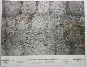
Map - FRED COWIE COLLECTION: AERIAL MAPS OF HEATHCOTE/EPPALOCK, 28-9-60
... Map, Heathcote C3, Aerial Survey of Victoria, Photo-map prepared by Department of Crown Lands and Survey from photographs taken in 1960.Copied photographically at the Central Plan Office. ...Map, Heathcote C3, Aerial Survey of Victoria, Photo-map prepared by Department of Crown Lands and Survey from photographs taken in 1960.Copied photographically at the Central Plan Office. ...Map, Heathcote C3, Aerial Survey of Victoria, Photo-map prepared by Department of Crown Lands and Survey from photographs taken in 1960.Copied photographically at the Central Plan Office. Date 28-9 60, C.P.O.Neg. No.21588.Campaspe River, Coliban River. Flower Hill. Fred Cowie,46 McIvor Rd.Bendigo (Not located 29.9.2022)Central Plan Office.map, heathcote, fred cowie -
 Bendigo Historical Society Inc.
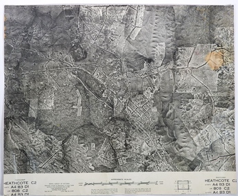
Map - FRED COWIE COLLECTION: AERIAL MAPS OF HEATHCOTE/EPPALOCK, 28-9-1960
... Map, Heathcote C2, Township of Heathcote, Melbourne Road through town branching off to Bendigo & Echuca. Aerial Survey of Victoria. Photo-map prepared by Department of Crown Lands and Survey from photographs taken in 1960. ...History House 11 Mackenzie Street Bendigo goldfields MAP Heathcote Fred Cowie Central Plan Office Map, Heathcote C2, Township of Heathcote, Melbourne Road through town branching off to Bendigo & Echuca. Aerial Survey of Victoria. Photo-map prepared by Department of Crown Lands and Survey from photographs taken in 1960. ...Map, Heathcote C2, Township of Heathcote, Melbourne Road through town branching off to Bendigo & Echuca. Aerial Survey of Victoria. Photo-map prepared by Department of Crown Lands and Survey from photographs taken in 1960. Copied photographically at the Central Plan Office.Fred Cowie,46 McIvor Rd,Bgo..Central Plan Officemap, heathcote, fred cowie -
 Bendigo Historical Society Inc.
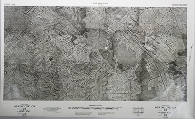
Map - FRED COWIE COLLECTION: AERIAL MAPS OF HEATHCOTE/EPPALOCK, 28-9-60
... Map, Heathcote C4, Aerial Survey of Victoria,Photo-map prepared by Department of Crown Lands and Survey from photographs taken in 1960. ...Map, Heathcote C4, Aerial Survey of Victoria,Photo-map prepared by Department of Crown Lands and Survey from photographs taken in 1960. ...Map, Heathcote C4, Aerial Survey of Victoria,Photo-map prepared by Department of Crown Lands and Survey from photographs taken in 1960. Copied photographically at the Central Plan Office.Date 28-9-60,C.P.O.Neg.No.21590.Scale 4 inches to 1 mile. Fred Cowie,46 McIvor Rd,Bgo..Central Plan Office.map, heathcote, fred cowie -
Bendigo Historical Society Inc.
Map - CAMPBELL COLLECTION: BENDIGO AND DISTRICT MAPS, June 1953
... Drawn and reproduced at the Department of Lands and Survey, Melbourne, Victoria. By Authority : W.M. ...Drawn and reproduced at the Department of Lands and Survey, Melbourne, Victoria. By Authority : W.M. ...Map. Marong, County of Bendigo, Scale 40 chains to 1 inch. Woodstock, Leichardt, Nerring, Sandhurst, Lockwood, Shelbourne. Drawn and reproduced at the Department of Lands and Survey, Melbourne, Victoria. By Authority : W.M. Houston, Government Printer. June 1953. Price 2/-. (number 403 in map cupboard 1)W.M. Houston, Government Printer.map, bendigo, agricultural lands -
Bendigo Historical Society Inc.
Map - CAMPBELL COLLECTION: BENDIGO AND DISTRICT MAPS, August 1952
... Drawn and reproduced at the Department of Lands and Survey, Melbourne, Victoria, August 1952. ...Drawn and reproduced at the Department of Lands and Survey, Melbourne, Victoria, August 1952. ...Map. Nerring, County of Bendigo, Yarraberb, Neilborough, Leichardt, Marong, Sandhurst, Huntly. Scale 20 chains to 1 inch. Drawn and reproduced at the Department of Lands and Survey, Melbourne, Victoria, August 1952. Price 2/-. By Authority J.J. Gourley, Government Printer, Melbourne. (number 404 in map cupboard 1)J.J. Gourley, Government Printermap, bendigo, allotments -
Bendigo Historical Society Inc.
Map - HUNTLY : COUNTY OF BENDIGO, August 1954
... Drawn and reproduced at the Department of Lands and Survey, Melbourne, Victoria. August 1954. ...Drawn and reproduced at the Department of Lands and Survey, Melbourne, Victoria. August 1954. ...Map. Huntly, County of Bendigo. Whirrakee, Bagshot, Wellsford, Nerring, Neilborough, Township of Huntly. Drawn and reproduced at the Department of Lands and Survey, Melbourne, Victoria. August 1954. Price 2/-. By authority W.M. Houston, Government Printer. (number 42 in map cupboard 1)W.M. Houston, Govt. Printer.map, bendigo, huntly -
Bendigo Historical Society Inc.
Map - WOODSTOCK : COUNTY OF BENDIGO, 4-7-35
... Drawn and reproduced at the Department of Lands and Survey, Melbourne, Victoria.4-7-35. Price 2/-. ...Drawn and reproduced at the Department of Lands and Survey, Melbourne, Victoria.4-7-35. Price 2/-. ...Map. Woodstock, County of Bendigo, Derby, Leichardt, Marong, Shelbourne, Laanecoorie, Tarnagulla. Bradford Creek, Maldon and Laanecoorie Railway. Drawn and reproduced at the Department of Lands and Survey, Melbourne, Victoria.4-7-35. Price 2/-. By authority H.J. Green,Govt. Printer. (number 41 in map cupboard 1)H.J. Green, Govt. Printer.map, bendigo, woodstock -
Bendigo Historical Society Inc.
Document - HARRY BIGGS COLLECTION: OLD POLICE BARRACKS, 5/6/70
... & Survey is investigating the future use & control of the old Police Barracks building.... & Survey is investigating the future use & control of the old Police Barracks building. ...Document. Harry Biggs Collection. A letter on Public Works Department Victoria letterhead from G. Serpell Director General to Mr H. Biggs, Treasurer Royal Historical of Victoria (Bendigo Branch) dated 5th June 1970. In the letter he is stating The Depart. Of Crown Lands & Survey is investigating the future use & control of the old Police Barracks building.G. Serpell Director Generalorganization, club/society, community, harry biggs collection, old police barracks -
 Flagstaff Hill Maritime Museum and Village
Document - Map, Department of Lands & Survey, Victoria / Panmure, 1942
... Cartographic Company, Survey Corps, which was formed in 1941. The Corp changed its name to L.H.Q. ...Lands and Survey in Melbourne, prepared by the Australian Section, Imperial General Staff and printed by A.H.Q. Cartographic Company, Melbourne in 1942. Crown Copyright Reserved. Inscriptions in red print state that it is and Emergency Edition and an Official document. An oval purple stamp includes the price. Victoria / Panmure Document Map Department ...This Emergency Edition of the map of Panmure, Victoria, is part of the W.R. Angus Collection. It was printed in 1942 during World War II. It is one of two maps donated to Flagstaff Hill Maritime Village by the family of Doctor William Roy Angus, who served as Surgeon Captain in the Australian Defence Department. The map was compiled for the Dept. of Army by the Dept. of Lands and Survey in Melbourne, prepared by the Australian Section of the Imperial General Staff, which was a British Government body created in 1907 to co-ordinate the defence of Britain and its Empire. It was printed by A.H.Q. Cartographic Company, Survey Corps, which was formed in 1941. The Corp changed its name to L.H.Q. Cartographic Company of Bendigo. In 1947 the name reverted back to the A.H.Q. Cartographic Company until 1955 when it became the A.H.Q. Survey Regiment. The W.R. Angus Collection includes historical medical equipment, surgical instruments and material once belonging to Dr Edward Ryan and Dr Thomas Francis Ryan, (both of Nhill, Victoria) as well as Dr Angus’ own belongings. The Collection’s history spans the medical practices of the two Doctors Ryan, from 1885-1926 plus that of Dr Angus who began practice in 1924. Dr. Angus served with the Australian Department of Defence as a Surgeon Captain during the Second World Was from 1942 to 1945. He served in Ballarat, Victoria, and in Bonegilla, N.S.W. until he suffering from a heart attack just before the war ended. ABOUT THE “W.R.ANGUS COLLECTION” - Doctor William Roy Angus M.B., B.S., Adel., 1923, F.R.C.S. Edin.,1928, was generally known as Dr Roy Angus. His working life included a position as a doctor with the Flying Doctor Service in Australia’s rural and remote areas. After many varied experiences Dr Angus and his family moved to Warrnambool in 1939 where he purchased “Birchwood,” the 1852 home and medical practice of Dr John Hunter Henderson. He was appointed on a part-time basis as Port Medical Officer in Warrnambool and held this position until the 1940’s when the government no longer required the service of a Port Medical Officer. Dr Angus was a surgeon at the Warrnambool Base Hospital 1939-1942. After further studies he commenced practice as an ophthalmologist in Warrnambool, pioneering in artificial eye improvements. He was Honorary Consultant Ophthalmologist to Warrnambool Base Hospital for 31 years and made monthly visits to Portland to perform eye surgery. Dr Angus and his wife Gladys were very involved in Warrnambool’s community with a strong interest in civic affairs. They were both involved in the creation of Flagstaff Hill Maritime Village, including the layout of the gardens. After his death on 28th March 1970 his family requested his practitioner’s plate, medical instruments and some personal belongings be displayed in the Port Medical Office surgery at Flagstaff Hill Maritime Village, and be called the “W. R. Angus Collection”. This Emergency Edition of the Map of Panmure is significant as an example of the documents prepared for the defence of Australia in World War 2. The Map is also significant for its connection between the Australian Army and the involvement of Dr WR Angus as a Surgeon in the Medical Services during World War II. The W.R. Angus Collection is significant for still being located at the site it is connected with, Doctor Angus being the last Port Medical Officer in Warrnambool. The collection of medical instruments and other equipment is culturally significant, being an historical example of medicine, administration, household equipment and clothing from late 19th to mid-20th century. Dr Angus assisted Dr Tom Ryan, a pioneer in the use of X-rays and in ocular surgery. The collection includes Dr Angus’s Army objects and is significant as an example of items issued to Doctors and Surgeons in the Medical Services of the Australian Army in World War IIMilitary map of Panmure, Victoria, Australia; part of the W.R. Angus Collection. Rectangular coloured map on cream paper for the Australian Army. Details include sea, waterways and land, contour lines, grid lines, names of districts, towns and roads, bridges, swamps, rail lines, cuttings, tracks, buildings (including blacksmiths), pumps, lighthouses, telegraph, telephones and electric transmission lines, and fire stations. The map has margin notes that include distances in miles to nearby towns. The map was compiled for the Dept. of Army by the Dept. of Lands and Survey in Melbourne, prepared by the Australian Section, Imperial General Staff and printed by A.H.Q. Cartographic Company, Melbourne in 1942. Crown Copyright Reserved. Inscriptions in red print state that it is and Emergency Edition and an Official document. An oval purple stamp includes the price.Printed in black; 'Victoria / Panmure", "No. 930 / Zone 6" Printed in red; “EMERGENCY EDITION”, “THIS MAP IS AN OFFICIAL DOCUMENT. IF FOUND, IT MUST BE HANDED / IN TO THE NEAREST MILITARY HEADQUARTERS OR POLICE STATION” Stamped: within concentric ovals (“- - - FOR SALE / PRICE 2/- / - - - - - OF THE ARMY”)flagstaff hill, warrnambool, flagstaff hill maritime museum, maritime museum, shipwreck coast, flagstaff hill maritime village, great ocean road, dr w r angus, dr ryan, warrnambool base hospital, flying doctor, surgeon captain, australian department of defence, royal australian army, world war 2, map panmure 1942, roy angus, port medical officer, nhill base hospital, military map, emergency map, military service australian army, department of army, department of lands and survey, a.h.q. cartographic company melbourne, panmure 1942, australian section, imperial general staff