Showing 107 items matching "victorian suburbs"
-
 Tatura Irrigation & Wartime Camps Museum
Book, Heidelberg. The land and its people. 1889 - 1900, 1972
... ...Victorian Suburbs...Tatura Irrigation & Wartime Camps Museum 49 Hogan Street Tatura the-murray History of Heidelberg, a suburb of Melbourne Heidelberg Victoria Victorian Suburbs Presented to Tatura & District Historical Society by J Forster 27-06-1990 Green hardcover, green dust cover, red printing on white background. ...History of Heidelberg, a suburb of MelbourneGreen hardcover, green dust cover, red printing on white background. Picture in black of elderly gentleman and old home. Presented to Tatura & District Historical Society by J Forster 27-06-1990heidelberg victoria, victorian suburbs -
 Greensborough Historical Society
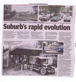
Newspaper Clipping, Diamond Valley Leader, Suburb's rapid evolution, 12/04/2017
... Eltham was described as a blossoming township and featured in the top 10 fastest growing Victorian suburbs during the 1960s. This article looks at some historic sites in Eltham and how they look today....Greensborough Historical Society 34A Glenauburn Road Lower Plenty Lower Plenty melbourne Eltham was described as a blossoming township and featured in the top 10 fastest growing Victorian suburbs during the 1960s. This article looks at some historic sites in Eltham and how they look today. eltham changes over times News article 2 pages, black text, colour image. ...Eltham was described as a blossoming township and featured in the top 10 fastest growing Victorian suburbs during the 1960s. This article looks at some historic sites in Eltham and how they look today.News article 2 pages, black text, colour image.eltham, changes over times -
 Warrnambool and District Historical Society Inc.
Book, Sands & McDougall Pty Ltd, Sands & McDougall’s Directory of Victoria and Canberra A.C.T. 1946, 1946
... The directory contains advertisements for Victorian and Canberra businesses, an index to streets in Melbourne and suburbs, an index to residents and businesses in Victoria and Canberra under suburb headings, and an alphabetical section of residents’ names....The directory contains advertisements for Victorian and Canberra businesses, an index to streets in Melbourne and suburbs, an index to residents and businesses in Victoria and Canberra under suburb headings, and an alphabetical section of residents’ names. ...Sands and McDougall Pty Ltd were manufacturing stationers established in all states of Australia. In Melbourne the manufacturing business was located in Spencer Street. The company published annual directories of residents and businesses in Australia from 1857 to 1974, and these directories today are highly sought after by genealogists and researchers. This directory for 1946 came from the archives of the Warrnambool Standard newspaper. This book will be of considerable use to researchers and those wanting family information regarding Victorian and Canberra residents and their addresses in the 1940s. This is a directory of 2416 pages. The front and back covers and the spine binding are missing. The directory contains advertisements for Victorian and Canberra businesses, an index to streets in Melbourne and suburbs, an index to residents and businesses in Victoria and Canberra under suburb headings, and an alphabetical section of residents’ names.sands & mcdougall, history of warrnambool -
 Warrnambool and District Historical Society Inc.
Film - Book, Bailliere’s Victorian Directory 1868-1870, Original directories published as follows: Bailliere’s Victorian Directory 1868 Bailliere’s Victorian Directory 1869 Bailliere’s Victorian Directory 1870 Bailliere’s Victorian Directory 1871/72 Bailliere’s Victorian Directory 1875 Bailliere’s Victorian Directory 1880/81
... Warrnambool and District Historical Society Inc. 2 Gilles Street (south of Merri St) Warrnambool great-ocean-road The Official post office directory of Victoria (Bailliere's) : containing the names, residences and occupations of the inhabitants of the post towns of the colony, inclusive of Melbourne and suburbs, arranged locally and alphabetically, with cross references / compiled by authority. This directory is a useful resource in researching people and towns of the given area. Bailliere’s Victorian ...The Official post office directory of Victoria (Bailliere's) : containing the names, residences and occupations of the inhabitants of the post towns of the colony, inclusive of Melbourne and suburbs, arranged locally and alphabetically, with cross references / compiled by authority. This directory is a useful resource in researching people and towns of the given area.Red plastic folder with white printed label attached to front cover. Contains printed index in plastic sleeve at front. Three plastic sleeves containing microfiche. Bailliere’s Victorian Directory 1868 Bailliere’s Victorian Directory 1869 Bailliere’s Victorian Directory 1870 Bailliere’s Victorian Directory 1871/72 Bailliere’s Victorian Directory 1875 Bailliere’s Victorian Directory 1880/81 : Ref 919.450025 written on index sheet alongside Victoria College Library stamp.bailliere’s victorian directory 1868, bailliere’s victorian directory 1869, bailliere’s victorian directory 1870, bailliere’s victorian directory 1871/72, warrnambool history -
 Eltham District Historical Society Inc
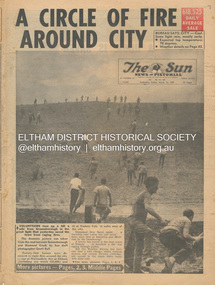
Newspaper - Newspaper articles, Sun News-Pictorial, A Circle of Fire Around City, The Sun News-Pictorial, Friday, March 12, p1, 1965
... Victorian bushfires specifically with a focus on fires at Eltham North. Specific Eltham Shire districts mentioned include Eltham, Diamond Creek, Warrandyte on page 1 and page 3, Warrandyte on page 4 • A Circle of Fire Around City, p1 (Illust.) • A home is saved, p2 (Illust.) • 18 houses, hall and store lost, p2 • Battle for the trees, p3 (Illust.) • Six houses go in two suburbs, p3 (Illust.) • A sleepless town waited, p4 (Illust.) • Fire in the near hills, pp28-29 (Illust.) ...Victorian bushfires specifically with a focus on fires at Eltham North. Specific Eltham Shire districts mentioned include Eltham, Diamond Creek, Warrandyte on page 1 and page 3, Warrandyte on page 4 • A Circle of Fire Around City, p1 (Illust.) • A home is saved, p2 (Illust.) • 18 houses, hall and store lost, p2 • Battle for the trees, p3 (Illust.) • Six houses go in two suburbs, p3 (Illust.) • A sleepless town waited, p4 (Illust.) • Fire in the near hills, pp28-29 (Illust.) ...Various news articles pertaining to the January 1965 Victorian bushfires specifically with a focus on fires at Eltham North. Specific Eltham Shire districts mentioned include Eltham, Diamond Creek, Warrandyte on page 1 and page 3, Warrandyte on page 4 • A Circle of Fire Around City, p1 (Illust.) • A home is saved, p2 (Illust.) • 18 houses, hall and store lost, p2 • Battle for the trees, p3 (Illust.) • Six houses go in two suburbs, p3 (Illust.) • A sleepless town waited, p4 (Illust.) • Fire in the near hills, pp28-29 (Illust.) tom fielding collection, victorian bushfires - 1965, victorian bushfires – 1965, greensborough, diamond creek, warrandyte, eltham, gippsland, romsey, toolern vale, melton, rockbank, laughing waters, ken guest, eltham state school no. 209, a. smith, ray freeman, sassafras, diamond creek-greensborough road, warrandyte hall, bushfire damage – buildings -
 Glen Eira Historical Society
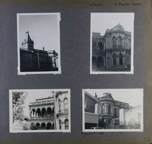
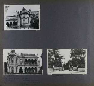
Album - Album page, Labassa, 4 Manor Grove, Circa 1972
... Victorian to be appointed Queen's Counsel in 1878. The significant development in 1890 of Ontario, is illustrative of the wealth of Alexander Robertson, a partner in Cobb and Co., a director of Goldsborough Mort & Co., and a pastoral speculator. John B. Watson, whose father had acquired great wealth from the goldfields of Bendigo and subsequently invested in city and country properties, was the third resident to impact on the house, particularly the interiors. The Labassa estate is of historical significance as an illustrative example of the development that occurred in such suburbs ...This photograph is part of the Caulfield Historical Album 1972. This album was created in approximately 1972 as part of a project by the Caulfield Historical Society to assist in identifying buildings worthy of preservation. The album is related to a Survey the Caulfield Historical Society developed in collaboration with the National Trust of Australia (Victoria) and Caulfield City Council to identify historic buildings within the City of Caulfield that warranted the protection of a National Trust Classification. Principal photographer thought to be Trevor Hart, member of Caulfield Historical Society. Most photographs were taken between 1966-1972 with a small number of photographs being older and from unknown sources. All photographs are black and white except where stated, with 386 photographs over 198 pages. HISTORY:-- From Victorian Heritage Database citation for Labassa https://vhd.heritagecouncil.vic.gov.au/places/278 as at (26/10/2020) Labassa, Caulfield is one of Melbourne's most lavishly decorated nineteenth century mansions. It resulted from the extensive remodelling in 1890, of an earlier house, known as Sylliott Hill, which was begun in 1862-3 for lawyer, Richard A. Billing. The land at the corner of Balaclava and Orrong Roads was first acquired in 1854 by William Lyall, transferred to his partner, John Mickle, in 1859, who also acquired the adjoining allotment in Balaclava Road, and the three allotments were conveyed to Billing. His first eight-roomed house was extended significantly in 1873 into a twenty-roomed house by architects Crouch and Wilson, who were possibly also responsible for the first house. This reflected Billing's success as a barrister, and he resided at this property until his death in 1882. In 1883 prominent Melbourne businessman, Alexander William Robertson, leased the Sylliott Hill property from Billing's widow, and in 1885 he purchased the adjoining allotment in Balaclava Road. He purchased the Billing's property in 1887 and renamed the 6.31 hectare property, Ontario. In 1889-90, Robertson commissioned the German born architect, John A. B. Koch, to extensively remodel the house into a thirty-five roomed mansion. The existing house was extended and altered, largely resulting in the nineteenth century mansion as it now appears. After Robertson's death in 1896, the house was tenanted until it was eventually sold to the mining millionaire, John Boyd Watson, in 1904. He renamed the property Labassa and carried out repair and re-decoration work to the house. In the early twentieth century, many large estates were subdivided into smaller allotments as the demand for land grew and it became difficult to maintain such large estates. After Watson's death in 1911, portions of the Labassa estate were offered for sale, with Mrs Watson retaining a 1.73 hectare portion containing the house. In 1913 forty-six allotments were auctioned at Labassa Estate, with the formation of Labassa Grove and Ontario Street to the east of the property. Labassa was first recorded as containing flats in 1923 and in the late 1920s, the owner, Robert Hannon, built a red brick block of flats adjacent to the house. Subdivision continued, until the National Trust of Australia (Victoria) purchased the house in 1980 and subsequently purchased adjoining sites, one to the south-east in 1984 (house demolished in 1988) and to the west in 1988. Labassa as it now stands is substantially as it appeared when Koch completed the work in 1890. The original two storey house was transformed into a French Renaissance style mansion, with the addition of a two level L-shaped arcaded verandah and two prominent terminating bays to the south and the east. The building is of unpainted cement render with dressed bluestone plinths, balustraded parapet and steep, slate covered, flat topped mansard roofs behind. A truncated conical roof is a feature of the south bay and a helmeted head is incorporated in the parapet over the east bay. The main south and east facades incorporate many cast cement details, including sculptures, elaborate cornices, swagged Corinthian columns and caryatid consoles flanking the entrance porch, as well as pink marble panels and imitation marble, or scagliola, on curved surfaces. At the rear of the building is a two storey wing and a single storey cottage, the former being connected to the main house by a tower. This section of the house was constructed in 1873. The estate at its peak included stables (1873), conservatory (probably 1890) and a tennis pavilion (probably 1890). All of these outbuildings survive, with the stables and conservatory being converted for residential use after 1922. Internally a range of decorative treatments remain from the late nineteenth century and the early twentieth century, both from the Robertson and Watson periods of occupancy. These include wallpapers, ceiling decoration, chimney pieces, mouldings, joinery and decorative glass. From Victorian Heritage Database citation for H0135 Labassa 2/2A Manor Grove Caulfield North https://vhd.heritagecouncil.vic.gov.au/places/278 as at (26/10/2020) HOW IS IT SIGNIFICANT? Labassa, Caulfield is of architectural, aesthetic and historical significance to the State of Victoria. WHY IS IT SIGNIFICANT? Labassa, Caulfield is of architectural significance as the most prominent example of a small number of houses built in Australia in the French Renaissance style. It is of further note due to the German interpretation of the style and the use of Hellenistic sources, via Germany. It is exceptional for its lavish treatment externally, including marble, scagliola, caryatids, swagged columns, mansard roofs and ornamental cresting. Labassa is of architectural significance as the most important surviving example of German architect, John Koch's domestic work. He undertook a large variety of work in Melbourne, including a number of houses, however Labassa is the most lavish example of his work. Labassa is of aesthetic significance for its outstanding assemblage of late nineteenth and early twentieth century European style interior decoration, which remain remarkably intact. These include a trompe l'oeil ceiling, painted ceilings, embossed imitation leather and other papers, chimney pieces, ceramic tilework, oak parquetry and stained glass, including a tripartite window by Ferguson and Urie, probably dating from the 1873 period. Labassa is of historical significance as an illustrative example of the wealth acquired by a number of prominent Victorian families in the second half of the 19th century. The early development of the property, Sylliott Hill, was due to the wealth acquired by Richard Billing, barrister and fifth Victorian to be appointed Queen's Counsel in 1878. The significant development in 1890 of Ontario, is illustrative of the wealth of Alexander Robertson, a partner in Cobb and Co., a director of Goldsborough Mort & Co., and a pastoral speculator. John B. Watson, whose father had acquired great wealth from the goldfields of Bendigo and subsequently invested in city and country properties, was the third resident to impact on the house, particularly the interiors. The Labassa estate is of historical significance as an illustrative example of the development that occurred in such suburbs as Caulfield in the 1880s due to the land boom, its proximity to Melbourne and the establishment of the Melbourne to Gippsland railway in 1879. It is also illustrative of an estate which succumbed to the pressures of subdividing in the early twentieth century, as properties became difficult to maintain and demand for land close to the city grew. It was typically divided into flats in the 1920s and was used as such for about sixty years. It is of historical significance for its associations with the remnants of the earlier estate which remain extant. These include the stables, conservatory (H2005) and tennis pavilion which all remain on separate sites. Also significant are the remains of early electrical wiring and fittings. Labassa was one of the first houses in Caulfield to be electrified and some of the original wires remain. [Online Data Upgrade Project 2004]Page 128 of Photograph Album with four photographs (two portrait and two landscape) of Labassa.Handwritten: "Labassa" 4 Manor Grove [top right] / Neg 232 8 Oct 1966 [under bottom right photo] / 128 [bottom right]trevor hart, bracketed eaves, slate roof, bay windows, decorative brackets, caulfield north, labassa, richard a. billing, balaclava road, orrong road, sylliott hill, william lyall, crouch and wilson, alexander william robertson, ontario, 1880's, john a. b. koch, mansion, john boyd watson, labassa grove, french renaissance style, l-shaped arcaded verandah, bluestone plinths, balustraded parapet, flat topped mansard roofs, conical roof, elaborate cornices, corinthian columns, caryatid consoles, marble panels, imitation marble, scagliola, tower, conservatory, stables, tennis pavilion, mouldings, decorative glass, caryatids, swagged columns, ornamental cresting, trompe l'oeil ceiling, embossed imitation leather, oak parquetry, stained glass, tripartite window, triple window, ferguson and urie, 1870's, flats, 1920's, electric wiring, 1860's, verandahs, curved windows, arched windows, italianate, terraces, gargoyles, ornamentation, ornate entrance, la bassa, manor grove, st kilda east, victorian, cast iron work, john koch, richard billing, architects, electrification, john mickle, land subdivision, mrs watson, labassa estate, robert hannon, national trust of australia (victoria), sculpture -
 Glen Eira Historical Society
Album - Album page, Labassa, 4 Manor Grove, Circa 1972
... Victorian to be appointed Queen's Counsel in 1878. The significant development in 1890 of Ontario, is illustrative of the wealth of Alexander Robertson, a partner in Cobb and Co., a director of Goldsborough Mort & Co., and a pastoral speculator. John B. Watson, whose father had acquired great wealth from the goldfields of Bendigo and subsequently invested in city and country properties, was the third resident to impact on the house, particularly the interiors. The Labassa estate is of historical significance as an illustrative example of the development that occurred in such suburbs ...This photograph is part of the Caulfield Historical Album 1972. This album was created in approximately 1972 as part of a project by the Caulfield Historical Society to assist in identifying buildings worthy of preservation. The album is related to a Survey the Caulfield Historical Society developed in collaboration with the National Trust of Australia (Victoria) and Caulfield City Council to identify historic buildings within the City of Caulfield that warranted the protection of a National Trust Classification. Principal photographer thought to be Trevor Hart, member of Caulfield Historical Society. Most photographs were taken between 1966-1972 with a small number of photographs being older and from unknown sources. All photographs are black and white except where stated, with 386 photographs over 198 pages. HISTORY:-- From Victorian Heritage Database citation for Labassa https://vhd.heritagecouncil.vic.gov.au/places/278 as at (26/10/2020) Labassa, Caulfield is one of Melbourne's most lavishly decorated nineteenth century mansions. It resulted from the extensive remodelling in 1890, of an earlier house, known as Sylliott Hill, which was begun in 1862-3 for lawyer, Richard A. Billing. The land at the corner of Balaclava and Orrong Roads was first acquired in 1854 by William Lyall, transferred to his partner, John Mickle, in 1859, who also acquired the adjoining allotment in Balaclava Road, and the three allotments were conveyed to Billing. His first eight-roomed house was extended significantly in 1873 into a twenty-roomed house by architects Crouch and Wilson, who were possibly also responsible for the first house. This reflected Billing's success as a barrister, and he resided at this property until his death in 1882. In 1883 prominent Melbourne businessman, Alexander William Robertson, leased the Sylliott Hill property from Billing's widow, and in 1885 he purchased the adjoining allotment in Balaclava Road. He purchased the Billing's property in 1887 and renamed the 6.31 hectare property, Ontario. In 1889-90, Robertson commissioned the German born architect, John A. B. Koch, to extensively remodel the house into a thirty-five roomed mansion. The existing house was extended and altered, largely resulting in the nineteenth century mansion as it now appears. After Robertson's death in 1896, the house was tenanted until it was eventually sold to the mining millionaire, John Boyd Watson, in 1904. He renamed the property Labassa and carried out repair and re-decoration work to the house. In the early twentieth century, many large estates were subdivided into smaller allotments as the demand for land grew and it became difficult to maintain such large estates. After Watson's death in 1911, portions of the Labassa estate were offered for sale, with Mrs Watson retaining a 1.73 hectare portion containing the house. In 1913 forty-six allotments were auctioned at Labassa Estate, with the formation of Labassa Grove and Ontario Street to the east of the property. Labassa was first recorded as containing flats in 1923 and in the late 1920s, the owner, Robert Hannon, built a red brick block of flats adjacent to the house. Subdivision continued, until the National Trust of Australia (Victoria) purchased the house in 1980 and subsequently purchased adjoining sites, one to the south-east in 1984 (house demolished in 1988) and to the west in 1988. Labassa as it now stands is substantially as it appeared when Koch completed the work in 1890. The original two storey house was transformed into a French Renaissance style mansion, with the addition of a two level L-shaped arcaded verandah and two prominent terminating bays to the south and the east. The building is of unpainted cement render with dressed bluestone plinths, balustraded parapet and steep, slate covered, flat topped mansard roofs behind. A truncated conical roof is a feature of the south bay and a helmeted head is incorporated in the parapet over the east bay. The main south and east facades incorporate many cast cement details, including sculptures, elaborate cornices, swagged Corinthian columns and caryatid consoles flanking the entrance porch, as well as pink marble panels and imitation marble, or scagliola, on curved surfaces. At the rear of the building is a two storey wing and a single storey cottage, the former being connected to the main house by a tower. This section of the house was constructed in 1873. The estate at its peak included stables (1873), conservatory (probably 1890) and a tennis pavilion (probably 1890). All of these outbuildings survive, with the stables and conservatory being converted for residential use after 1922. Internally a range of decorative treatments remain from the late nineteenth century and the early twentieth century, both from the Robertson and Watson periods of occupancy. These include wallpapers, ceiling decoration, chimney pieces, mouldings, joinery and decorative glass.From Victorian Heritage Database citation for H0135 Labassa 2/2A Manor Grove Caulfield North https://vhd.heritagecouncil.vic.gov.au/places/278 as at (26/10/2020) HOW IS IT SIGNIFICANT? Labassa, Caulfield is of architectural, aesthetic and historical significance to the State of Victoria. WHY IS IT SIGNIFICANT? Labassa, Caulfield is of architectural significance as the most prominent example of a small number of houses built in Australia in the French Renaissance style. It is of further note due to the German interpretation of the style and the use of Hellenistic sources, via Germany. It is exceptional for its lavish treatment externally, including marble, scagliola, caryatids, swagged columns, mansard roofs and ornamental cresting. Labassa is of architectural significance as the most important surviving example of German architect, John Koch's domestic work. He undertook a large variety of work in Melbourne, including a number of houses, however Labassa is the most lavish example of his work. Labassa is of aesthetic significance for its outstanding assemblage of late nineteenth and early twentieth century European style interior decoration, which remain remarkably intact. These include a trompe l'oeil ceiling, painted ceilings, embossed imitation leather and other papers, chimney pieces, ceramic tilework, oak parquetry and stained glass, including a tripartite window by Ferguson and Urie, probably dating from the 1873 period. Labassa is of historical significance as an illustrative example of the wealth acquired by a number of prominent Victorian families in the second half of the 19th century. The early development of the property, Sylliott Hill, was due to the wealth acquired by Richard Billing, barrister and fifth Victorian to be appointed Queen's Counsel in 1878. The significant development in 1890 of Ontario, is illustrative of the wealth of Alexander Robertson, a partner in Cobb and Co., a director of Goldsborough Mort & Co., and a pastoral speculator. John B. Watson, whose father had acquired great wealth from the goldfields of Bendigo and subsequently invested in city and country properties, was the third resident to impact on the house, particularly the interiors. The Labassa estate is of historical significance as an illustrative example of the development that occurred in such suburbs as Caulfield in the 1880s due to the land boom, its proximity to Melbourne and the establishment of the Melbourne to Gippsland railway in 1879. It is also illustrative of an estate which succumbed to the pressures of subdividing in the early twentieth century, as properties became difficult to maintain and demand for land close to the city grew. It was typically divided into flats in the 1920s and was used as such for about sixty years. It is of historical significance for its associations with the remnants of the earlier estate which remain extant. These include the stables, conservatory (H2005) and tennis pavilion which all remain on separate sites. Also significant are the remains of early electrical wiring and fittings. Labassa was one of the first houses in Caulfield to be electrified and some of the original wires remain. [Online Data Upgrade Project 2004]Page 129 of Photograph Album with three landscape photographs of Labassa. One of the photographs is of Labassa's drive and gates.Handwritten: 4 JUNE 1910 / SALE JUNE 28 1910 "LA BASSA' / "AUSTRALASIAN" FORMERLY "ONTARIO"/ RES OF JOHN B WATSON / 15 ACRES 3 ROADS [under bottom left photo] / 4 JUNE 1910 [under bottom right photo] / 129 [bottom left]trevor hart, bracketed eaves, intricate lacework, slate roof, bay windows, decorative brackets, caulfield north, labassa, richard a. billing, balaclava road, orrong road, sylliott hill, william lyall, crouch and wilson, alexander william robertson, ontario, 1880's, john a. b. koch, mansion, john boyd watson, labassa grove, french renaissance style, l-shaped arcaded verandah, bluestone plinths, balustraded parapet, flat topped mansard roofs, conical roof, elaborate cornices, corinthian columns, caryatid consoles, marble panels, imitation marble, scagliola, tower, conservatory, stables, tennis pavilion, mouldings, decorative glass, caryatids, swagged columns, ornamental cresting, trompe l'oeil ceiling, embossed imitation leather, oak parquetry, stained glass, tripartite window, triple window, ferguson and urie, 1870's, flats, 1920's, electric wiring, 1860's, verandahs, curved windows, arched windows, italianate, terraces, gargoyles, ornamentation, ornate entrance, la bassa, manor grove, st kilda east, gates, cast iron work, richard billing, architects, john koch, electrification, victorian style, drives, john mickle, land subdivision, mrs watson, labassa estate, robert hannon, national trust of australia (victoria), sculpture -
 Glen Eira Historical Society
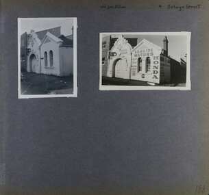
Album - Album page, Old Fire Station, 4 Selwyn Street, Circa 1972
... Victorian Heritage Register https://vhd.heritagecouncil.vic.gov.au/places/2645 (as at 21/11/2021) The Former Elsternwick Fire Station was built and commenced operation in 1896. It was one of 32 new fire stations built between 1892 and 1896 by the newly formed Melbourne Metropolitan Fire Brigade ('MFB') to form a comprehensive fire-fighting network across Melbourne. The MFB was established in 1891 as Victoria's government-run fire-fighting service in Melbourne and its growing suburbs...Victorian Heritage Register https://vhd.heritagecouncil.vic.gov.au/places/2645 (as at 21/11/2021) The Former Elsternwick Fire Station was built and commenced operation in 1896. It was one of 32 new fire stations built between 1892 and 1896 by the newly formed Melbourne Metropolitan Fire Brigade ('MFB') to form a comprehensive fire-fighting network across Melbourne. The MFB was established in 1891 as Victoria's government-run fire-fighting service in Melbourne and its growing suburbs ...This album was created in approximately 1972 as part of a project by the Caulfield Historical Society to assist in identifying buildings worthy of preservation. The album is related to a Survey the Caulfield Historical Society developed in collaboration with the National Trust of Australia (Victoria) and Caulfield City Council to identify historic buildings within the City of Caulfield that warranted the protection of a National Trust Classification. Principal photographer thought to be Trevor Hart, member of Caulfield Historical Society. Most photographs were taken between 1966-1972 with a small number of photographs being older and from unknown sources. All photographs are black and white except where stated, with 386 photographs over 198 pages. From Victorian Heritage Database citation for H2376 Former Elsternwick Fire Station, 2-4 Selwyn Street Elsternwick - Victorian Heritage Register https://vhd.heritagecouncil.vic.gov.au/places/2645 (as at 21/11/2021) The Former Elsternwick Fire Station was built and commenced operation in 1896. It was one of 32 new fire stations built between 1892 and 1896 by the newly formed Melbourne Metropolitan Fire Brigade ('MFB') to form a comprehensive fire-fighting network across Melbourne. The MFB was established in 1891 as Victoria's government-run fire-fighting service in Melbourne and its growing suburbs. By 1918 motorised fire engine appliances had replaced horse-drawn fire vehicles across the metropolitan area, and the consequently larger areas that fire stations could protect meant the 1896 Elsternwick Fire Station was one of many which was becoming obsolete. The MFB continued to use the Elsternwick Fire Station up until the Station's closure in 1926. From 1927 the former Fire Station was leased by neighbouring timber merchants JJ Webster Pty Ltd who subsequently purchased the property from the MFB in 1934. From 1954 the 'Esquire Motors' car repair business traded at the site, and changes to the former Fire Station building including the complete enclosure of its yard by corrugated steel walls and roofing appear to have been completed in the mid-1950s. In 1990 the Australian Broadcasting Corporation ('ABC') purchased the former Fire Station together with five other adjoining land parcels in Selwyn Street. From that time until 2017 the former Elsternwick Fire Station has been used by the ABC as office and storage space in its Selwyn Street television studio complex.From Victorian Heritage Database citation for H2376 Former Elsternwick Fire Station, 2-4 Selwyn Street Elsternwick - Victorian Heritage Register https://vhd.heritagecouncil.vic.gov.au/places/2645 (as at 21/11/2021) The Former Elsternwick Fire Station is historically significant as one of the 10 remaining fire stations of the original 32 built for the newly established Melbourne Metropolitan Fire Brigade ('MFB') during the four-year period 1892 to 1896. These fire stations were constructed following the establishment in 1891 of the MFB, Victoria's government-run fire-fighting service for metropolitan Melbourne and its growing suburban population. These new stations formed a crucial part of the MFB's fire-fighting network across Melbourne. The Former Elsternwick Fire Station clearly demonstrates the historical development of fire-fighting services in Melbourne, especially the expansion of the newly-formed MFB throughout Melbourne's suburbs during the 1890s. [Criterion A] The Former Elsternwick Fire Station is architecturally significant as a fine example of a late nineteenth century fire station. Constructed shortly after the establishment of the MFB, it displays characteristics of its class of place that remain mostly unchanged from the former Station's historically important period of development and use. A particularly strong element of the Former Elsternwick Fire Station is the large and strikingly-detailed stone horseshoe arch, designed for horse-drawn fire-fighting vehicles, at the street entrance to its fire-engine room. [Criterion D]Page 188 of Photograph Album with two photographs of the old Elsternwick Fire Station.Handwritten: old fire station 4 Selwyn Street [top right] / 188 [bottom right]trevor hart, rendered, 1890's, melbourne metropolitan fire brigade, mfb, fire-fighting, jj webster, timber merchants, esquire motors, car repair, australian broadcasting corporation, abc, selwyn street, brick and stone, asymmetrical facade, anglo-dutch gable, rusticated and smooth-faced limestone, elsternwick fire station, elsternwick, fire station, jj webster pty ltd, motor vehicle repair shops, stone horseshoe arch entrance -
 Eltham District Historical Society Inc
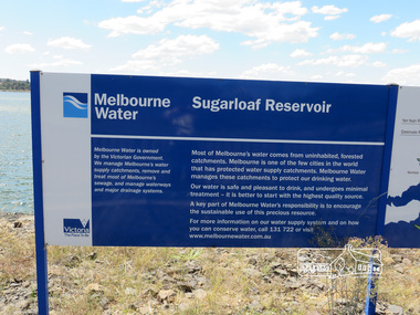
Photograph, Sugarloaf Reservoir, Christmas Hills, 16 January 2015, 16 January 2015
... suburbs. Within the visitor areas are two picnic grounds and other recreational facilities. Below its massive rock embankment is located the Winnecke Treatment Plan designed to purify its water before being piped into Melbourne. The dam partly inundated the old firing ranges of the former Christmas Hills Rifle Club. Source: Christmas Hills Now and then: Yarra Glen & District Historical Society, 2004. christmas hills sugarloaf reservoir sign Melbourne Water Melbourne Water Sugarload reservoir Melboure Water is owned by the Victorian ...Sugarloaf Reservoir is situated on former farmland. This large water storage was completed in 1982 and serves Melbourne's northern suburbs. Within the visitor areas are two picnic grounds and other recreational facilities. Below its massive rock embankment is located the Winnecke Treatment Plan designed to purify its water before being piped into Melbourne. The dam partly inundated the old firing ranges of the former Christmas Hills Rifle Club. Source: Christmas Hills Now and then: Yarra Glen & District Historical Society, 2004. Born DigitalMelbourne Water Sugarload reservoir Melboure Water is owned by the Victorian Government. We manage Melbourne's water supply catchments, remove and treat most of Melbourne's sewrage, and manage waterways and major drainage systems. Most of Melbourne's water comes from uninhabited, forested catchments. Melbourne is one of the few cities in the world that has protecyed water supply catchments. Melbourne Water manages these catchments to protect our drinking water. Our water is safe and pleasant to drink, and undergoes minimal treatment - it is better to start witht he highest quality source. A key part of Melbourne Water's responsibility is to encourage the sustainable use of this precious resource. For more inforamtio on our water supply and on how you can conserve water, call 131 722 or visit www.melbournewater.com.auchristmas hills, sugarloaf reservoir, sign, melbourne water -
 Victorian Interpretive Projects Inc.
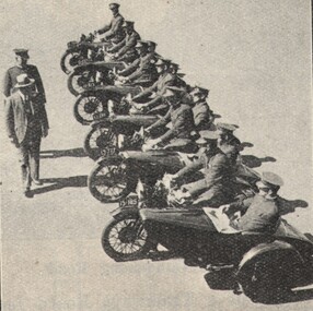
Image, Motorcycle Police, 1934, c1934
... Victorian Interpretive Projects Inc. PO Box 93R, Redan, 3350 goldfields In 1934 Melbourne city and suburbs were divided into areas and patrols. ...In 1934 Melbourne city and suburbs were divided into areas and patrols. The patrols were covered by motor cycles, bicycles and foot constables. Eleven police officers sit on motorbikes with side cars, and are being inspected by two people.police, motorcycle, motorbike, -
 Bendigo Historical Society Inc.
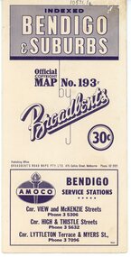
Map - Three Road Maps of Bendigo, 1962
... Victorian Wheelmen in October 1893, Broadbent contested the first Warrnambool-Melbourne race in 1895, and was active in the Good Roads Movement. Next year he issued a road map of Victoria, 'prepared … after some sixteen years riding and touring in all parts of the Colony', which indicated general topography, distances, and roads classified as 'good', 'fair' or 'ridden with difficulty'. It was to become Victoria's standard map, and the basis of a continuous publishing programme by Broadbent's Official Road Guides Co. history Bolton's Bendio Broadbent maps Three Road Maps of Bendigo, Bendigo and Suburbs ...George Robert Broadbent (1863-1947), cyclist and map publisher, was born on 3 November 1863 at Ashby near Geelong, Victoria, son of George Adam Broadbent, Lancashire-born draper, and his wife Elizabeth, née Ruffhead. When the family moved to North Melbourne Broadbent attended the Errol Street school, followed his father's trade, and became an early cycling and cycle-racing enthusiast. At various times Broadbent held most Victorian and Australian road records, and two of his performances on solid tyres—203 miles (327 km) in 24 hours on a penny farthing, and 100 miles (161 km) in 6 hours 20 minutes on a 'safety' bicycle—were never bettered. He established records for all distances between 130 and 220 miles (209 and 354 km), and for all times between 8 and 12 hours, at the Exhibition Grounds track in May 1894, and road records for 50 and 100 miles (80 and 161 km) in October 1896. The Australian Cyclist acknowledged him 'the finest road rider that Australia has ever produced'. A foundation councillor of the League of Victorian Wheelmen in October 1893, Broadbent contested the first Warrnambool-Melbourne race in 1895, and was active in the Good Roads Movement. Next year he issued a road map of Victoria, 'prepared … after some sixteen years riding and touring in all parts of the Colony', which indicated general topography, distances, and roads classified as 'good', 'fair' or 'ridden with difficulty'. It was to become Victoria's standard map, and the basis of a continuous publishing programme by Broadbent's Official Road Guides Co.Three Road Maps of Bendigo, Bendigo and Suburbs, Bendigo and Eaglehawk. Two fold out maps printed in colour and produced by Broadbent's Road Maps Pty. Ltd. 475 Collins Street Melbourne. One map printed by Bolton's Bendigo.history, bolton's, bendio broadbent maps -
 Ringwood and District Historical Society
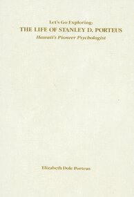
Book, Elizabeth Dole Porteus, Let's Go Exploring: The Life Of Stanley D. Porteus - Hawaii's Pioneer Psychologist, 1991
... suburbs of Melbourne such as Canterbury, Mitcham and Ringwood, Box Hill was a mere village. Each was surrounded by bush. He grew up like most Australian boys with a love of sport and, although lightly built, did quite well at Australian Rules football and was above average at cricket. He became a schoolteacher with the Victorian...suburbs of Melbourne such as Canterbury, Mitcham and Ringwood, Box Hill was a mere village. Each was surrounded by bush. He grew up like most Australian boys with a love of sport and, although lightly built, did quite well at Australian Rules football and was above average at cricket. He became a schoolteacher with the Victorian ...White hard covered book. Biography by daughter-in-law of Stanley Porteus, pioneer of modern psychology and one-time resident of Ringwood, Victoria. SUMMARY NOTES. Stanley David Porteus was born in Box Hill, Victoria, Australia in 1883, the only son of a Methodist minister. Like other now large suburbs of Melbourne such as Canterbury, Mitcham and Ringwood, Box Hill was a mere village. Each was surrounded by bush. He grew up like most Australian boys with a love of sport and, although lightly built, did quite well at Australian Rules football and was above average at cricket. He became a schoolteacher with the Victorian Education Department. Promotion within the department depended on experience gained at teaching in tiny rural schools so he applied for such a position at Glenaladale, on the Dargo Road, some 35 miles north west of Bairnsdale. He walked about 6 miles from the nearest railway station at Fernbank to find the school surrounded by virgin forest with only one dwelling in sight. Attached to the school were lean-to rooms that were to be his residence for the next 2 ½ years. He was fascinated by the nearby Den of Nargun and Bull Creek, which joined the Mitchell River in a deep gorge containing a profusion of rainforest vegetation. While at Glenaladale, he met Frances Evans who became his wife. To seek promotion, he left Glenaladale and taught at Leneva and Benambra. While at the latter school, he learned of a position becoming available as superintendent of special schools in Melbourne. As the available means of transport, coach and horses to Bairnsdale, then by train to Melbourne, would not get him to Melbourne before the close of applications, he borrowed a bicycle and rode through the bush to his in-laws home at Lindenow and thus made it before the deadline. He was successful in his application and it set him on a course that lead to him becoming Australia's first Clinical Psychologist. His work, particularly, the development of the Porteus Maze Test, attracted the attention of American educators and he was offered an appointment for a year at Vineland Training School in New Jersey. On a stopover in Honolulu, he was impressed to the extent that he expressed a desire to work there. Not the least of its attractions was the mix of races that offered opportunities to study psychological differences, if any, between various races. His wish was to be granted unexpectedly as he was, in 1919, invited to Honolulu to set up a Psychological and Psychopathic Clinic at the University of Hawaii. From his home in the hills north of Honolulu, on December 7th 1941, he saw the Japanese attack on Pearl Harbour. He lived there until his death in about 1980. -
 Greensborough Historical Society
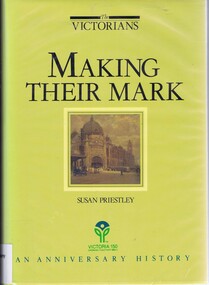
Book, Making their mark: The Victorians; by Susan Priestley, 1984_
... Published to commemorate the 150th anniversary of the European settlement of Victoria victoria land use victoria economic conditions victoria history victoria social conditions susan priestley melbourne suburbs Hard cover. 382 pages, illus., maps. Making their mark: The Victorians; by Susan Priestley Book Book Fairfax,Syme and Weldon ...This text deals with the economic development of Victoria in the 19th and early 20th century.Published to commemorate the 150th anniversary of the European settlement of VictoriaHard cover. 382 pages, illus., maps.victoria land use, victoria economic conditions, victoria history, victoria social conditions, susan priestley, melbourne suburbs -
Ballarat Tramway Museum
Sign - Sign - Destination Blinds, Trains, Victorian Rail Suburban Train Destination Blind in Miniature: Williamstown and areas north, south etc
... suburbs that the train travels to. Place names listed are Altona, Westona, Newport, Laverton, Werribee, Williamstown, Williamstown Pier, Sunshine, St Albans, Sunbury, Deer Park West, Melton, Essendon, Broadmeadows, Craigieburn, Coburg, Cowrie, Upfield, Reservoir. Blind also indicates Show Special and Race Special. train destination blinds miniature railway stations reservoir upfield cowrie coburgcraigieburn broadmeadows essendon melton deer park west sunbury st albans sunshine williamstown pier werribee laverton williamstown newpoort westona altona newport workshops race special show special special ron bridger collection Place names - stations `List of names on black paper with white print. Victorian ...Ron Bridger was an avid collector of items related to transport, predominately Trams. These items include newspaper cuttings, pamphlets, reports, timetables, fares prices plus special items relating to events. Items from Melbourne and regional Victoria, interstate - Adelaide and Sydney, plus overseas, make up this collection. A suburban train destination blind in miniature. Place names indicate the western and northern suburbs that the train travels to. Place names listed are Altona, Westona, Newport, Laverton, Werribee, Williamstown, Williamstown Pier, Sunshine, St Albans, Sunbury, Deer Park West, Melton, Essendon, Broadmeadows, Craigieburn, Coburg, Cowrie, Upfield, Reservoir. Blind also indicates Show Special and Race Special.`List of names on black paper with white print.Place names - stationstrain destination blinds, miniature, railway stations, reservoir, upfield, cowrie, coburgcraigieburn, broadmeadows, essendon, melton, deer park west, sunbury, st albans, sunshine, williamstown pier, werribee, laverton, williamstown, newpoort, westona, altona, newport workshops, race special, show special, special, ron bridger collection -
 Ballarat Tramway Museum
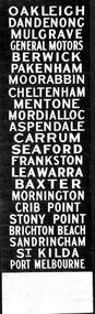
Sign - Sign - Destination Blinds, Trains, Victorian Rail Suburban Train Destination Blind in Miniature: South Eastern Region
... suburbs that the train travels to. Place names listed are from Oakleigh to Dandenong, Mulgrave, General Motors, Berwick and Pakenham. From Moorabbin, Cheltenham, Mentone, Mordiallic, Aspendale, Carrum and Seaford. Frankston to Leawarra, Baxter, Mornington, Crib Point, Stony Point, Brighton Beach, Sandringham, St Kilda and Port Melbourne train destination blinds miniature railway stations ron bridger collection suburban train oakleigh dandenong berwick pakenham moorabbin cheltenham mentone mordiallic aspendale seaford baxter mornington crib point brighton beach port melbourne Place names - stations List of names on black paper with white print. Victorian ...Ron Bridger was an avid collector of items related to transport, predominately Trams. These items include newspaper cuttings, pamphlets, reports, timetables, fares prices plus special items relating to events. Items from Melbourne and regional Victoria, interstate - Adelaide and Sydney, plus overseas, make up this collection. A suburban train destination blind in miniature. Place names indicate the eastern and southern suburbs that the train travels to. Place names listed are from Oakleigh to Dandenong, Mulgrave, General Motors, Berwick and Pakenham. From Moorabbin, Cheltenham, Mentone, Mordiallic, Aspendale, Carrum and Seaford. Frankston to Leawarra, Baxter, Mornington, Crib Point, Stony Point, Brighton Beach, Sandringham, St Kilda and Port MelbourneList of names on black paper with white print.Place names - stationstrain destination blinds, miniature, railway stations, ron bridger collection, suburban train, oakleigh, dandenong, berwick, pakenham, moorabbin, cheltenham, mentone, mordiallic, aspendale, seaford, baxter, mornington, crib point, brighton beach, port melbourne -
 Sunshine and District Historical Society Incorporated
Journal - Victorian Historical Journal Volume 85 Number 2 December 2014, Royal Historical Society of Victoria, December 2014
... Suburbs contain vast amounts of Milk thistle. Carduus marianus John Dwyer Thistle Scotch Thistle Article Page 276: Attempts to Deal with Thistles in Mid 19th Century Victoria by John Dwyer Although other weeds were present in Victoria in the 1850s, the general perception was that thistles were the weeds most feared, and the need of an effective response. In 1850' Superintendent La Trobe reacted to public concerns by publishing a notice calling for measures to control the spread of Milk thistle. Victorian ...Article Page 276: Attempts to Deal with Thistles in Mid 19th Century Victoria by John Dwyer Although other weeds were present in Victoria in the 1850s, the general perception was that thistles were the weeds most feared, and the need of an effective response. In 1850' Superintendent La Trobe reacted to public concerns by publishing a notice calling for measures to control the spread of Milk thistle.Paperback book with glossy front covernon-fictionArticle Page 276: Attempts to Deal with Thistles in Mid 19th Century Victoria by John Dwyer Although other weeds were present in Victoria in the 1850s, the general perception was that thistles were the weeds most feared, and the need of an effective response. In 1850' Superintendent La Trobe reacted to public concerns by publishing a notice calling for measures to control the spread of Milk thistle.carduus marianus, john dwyer, thistle, scotch thistle -
 Sunshine and District Historical Society Incorporated
Journal - Victorian Historical Journal Volume 82 Number 1 June 2011, Royal Historical Society of Victoria, November 2009
... Brimbank Library, 301 Hampshire Road, Sunshine 3020. melbourne Migrants Immigration Macedonian Article Page 30: The Arrival and Settlement of Macedonians in the Inner Western Suburbs of Melbourne by Nick Anastasovski. Article refers to employment in Sunshine and Footscray. Victorian ...Article Page 30: The Arrival and Settlement of Macedonians in the Inner Western Suburbs of Melbourne by Nick Anastasovski. Article refers to employment in Sunshine and Footscray.Paperback book with glossy front covernon-fictionArticle Page 30: The Arrival and Settlement of Macedonians in the Inner Western Suburbs of Melbourne by Nick Anastasovski. Article refers to employment in Sunshine and Footscray.migrants, immigration, macedonian -
 City of Melbourne Libraries
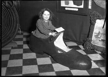
Photograph, Bull, Hugh Jones, 1897-1993, Leather Exhibition, Melbourne Town Hall
... Retrieved February 7, 2026, from http://nla.gov.au/nla.news-article3888451 Melbourne Circle: stories from the suburbs: “Boots and all in Clifton Hill” https://melbournecircle.net/2015/11/20/bootmakers-of-clifton-hill/ Wikipedia, Maurice Tate, https://en.wikipedia.org/wiki/Maurice_Tate Wikipedia, Harold Larwood, https://en.wikipedia.org/wiki/Harold_Larwood Wikipedia, Iftikhar Ali Khan Pataudi, https://en.wikipedia.org/wiki/Iftikhar_Ali_Khan_Pataudi Buy Leather Online Italy, Sole leather: https://buyleatheronline.com/en/blog/outsole-and-insole-leather-n7 London Museum, Porters hats, https://www.londonmuseum.org.uk/collections/v/object-731122/hat-porters-hat/ Cameo Database, Museum of Fine Arts, Boston, Glace Kid, https://cameo.mfa.org/wiki/Glac%C3%A9_kid VICTORIAN LEATHER HAS WON RENOWN (1937, September 22). ...Retrieved February 7, 2026, from http://nla.gov.au/nla.news-article3888451 Melbourne Circle: stories from the suburbs: “Boots and all in Clifton Hill” https://melbournecircle.net/2015/11/20/bootmakers-of-clifton-hill/ Wikipedia, Maurice Tate, https://en.wikipedia.org/wiki/Maurice_Tate Wikipedia, Harold Larwood, https://en.wikipedia.org/wiki/Harold_Larwood Wikipedia, Iftikhar Ali Khan Pataudi, https://en.wikipedia.org/wiki/Iftikhar_Ali_Khan_Pataudi Buy Leather Online Italy, Sole leather: https://buyleatheronline.com/en/blog/outsole-and-insole-leather-n7 London Museum, Porters hats, https://www.londonmuseum.org.uk/collections/v/object-731122/hat-porters-hat/ Cameo Database, Museum of Fine Arts, Boston, Glace Kid, https://cameo.mfa.org/wiki/Glac%C3%A9_kid VICTORIAN LEATHER HAS WON RENOWN (1937, September 22). ...Photographer notations on slide: At the Leather Exhib. at T. Hall Melb 1933 Age Published: Age (Melbourne, Vic.: 1854- ), 1933 THE EXHIBITS. (1933, September 20). The Age (Melbourne, Vic. : 1854 - 1954), p. 16. Retrieved January 25, 2026, from http://nla.gov.au/nla.news-article205109730 Published title: THE EXHIBITS. A COMPREHENSIVE RANGE. Curios, Novelties, Working Displays Published Caption: ONE OF THE NOVELTIES – AN OUTSIZE IN SHOES Research by Project Volunteer, Louise McKenzie: Our photo is dated 20 September 1933, and shows a happy, chubby-faced young girl sitting in a very over-sized girl’s shoe. It is labelled – “Shoe, An Out Size, loaned by Messrs Blackman & Rose”. (1) It is an effective way to capture the attention of the readership and alert them to the Melbourne Leather Show 1933. This show was designed to be a drawcard of extraordinary proportion, and there is no doubt that this leather exhibition was a really big deal for Melbourne. It completely took over the Melbourne Town Hall, and was open from 10.30 am until 10.30 pm. It seemed to contain something for everyone – the military, the man about town, the home handyman, the housewife, the child, the sporting types, the domestic workers, the outdoor enthusiasts, the horseracing fans, car enthusiasts, those wishing to show off the latest fashion – both men and women - and those just intrigued by a lot of fascinating and wide ranging exhibits. One of the most comprehensive descriptions of the Exhibition accompanies the photograph, and is worth quoting in full: “PROMINENT among exhibits which first attract attention in the foyer of the Town Hall is a comprehensive display of leather articles used by the defence forces. A conspicuous legend states that leather plays an important part in national defence, being used for saddlery, tool containers, holdalls, range-finding, surveying and signalling equipment, explosives factories, harness accoutrement, bandsmen's equipment and clothing. Three models of horses and several figures of soldiers wearing leather equipment illustrate the lesson, and a great range of leather goods used in military training and work variegate the display. Nearby are Texas cowboy, buckjumping and breaking-in saddles; whips, a walking stick, made of leather and numerous other curios. The general exhibition occupies the whole floor space of the main Town Hall, and is subdivided by partitions running most of the length of the hall. A bewildering variety, of leather goods presses for close and leisured inspection. Here and there operatives in charge of working machinery give practical demonstrations of factory processes in the production of footwear. Polishing materials are well represented. One attractive exhibit includes two bush huts constructed of leather, with wattle bark for roofing. Opossums, rosellas and a kookaburra add touches of bush realism. Adjacent exhibits include bags, fishing boots, leggings, leather covers in all colours. Factory Processes. One exhibitor has installed an automatic cinema apparatus and screen, which projects various factory processes in making a shoe, the operator being shown at work. Elsewhere an interesting exhibit depicts the five stages in the manufacture of sole leather, and the tanning materials employed. "Very handsome effects are achieved in the interior appointments of motor cars, which are attended by figures of smart chauffeurs in leather coats. Motor-trimming leather is said to be more durable and hygienic than fabric materials, and cheaper. The neat finish of the material, its excellent appearance, certainly make a very favourable impression. It takes the hides of three beasts to cover the cushions, squabs and door panels of a full-sized sedan, while to finish the entire interior, including quarter-panels and head linings would take four or even five. Special Exhibits. Amongst the special sections the display arranged by the handicrafts and home industries- committee of the Country Women's Association of Victoria is a notable one. In all there are about 130 entries which are in four classifications, viz., hand-tooled or embossed leathers, suede, hand-made gloves and undecorated leather. The glove section attracted the most numerous entries, a number being the work of members and craft subscribers of the Country Women's Association. In the leathercraft competition, organised by the Country Women's Association, the judges yesterday awarded the first prize for bookbinding (the only prize given in this division) to Miss M. Alston, of South Yarra. There is also a creditable display of exhibits submitted by boys of the orthopaedic section of the Children's Hospital at Frankston. Amongst the novelties on view in other portions of the exhibition were the following: — Leather coats worn by Sir C. Kingsford Smith on his Atlantic flight. Model Wellington boot, Phar Lap's saddle. Melbourne Cup winner's saddle. Longest whip in world, 108 feet long. (33 metres) [See our photo, to left of Girl in Shoe] Diminutive shoes. Pair of shoes 65 years old. Pair of men's working boots 75 years old. Larwood's, Tate’s and Pataudi’s cricket boots. [Three internationally revered cricketers of the day] (2) Picture frame made of leather bought 63 years ago. [See our photo, to right of Girl in Shoe] Leather frame, powder bowl, &c. Saddle used by world's champion buckjumper in U.S.A. Mexican cowboy outfit. Miniature saddle and bridle. A fireman's helmet made of sole leather. (3) Sample of the leather hat worn by porters at the Billingsgate Fish Market, London. (4) From South Australia there have been obtained sets of harness for donkeys, goats and camels, the equipment being displayed to good advantage on stuffed representations of the animals mentioned. Close to the platform is a glass case containing snow shoes and coats which have been used in Antarctic exploration work. Trade Display. Amongst the trade exhibits may be seen in operation a slipper turn shoe sewing machine, with heeling and channelling facilities, and the various stages in the production of ladies' sandals are shown. There is a wide contrast between sole leather of varying degrees of thickness on view in one stall and the choice samples of ladies' footwear in another — footwear, by the way, which could almost be used as ornaments, so dainty in colour and production are they. Again, there are displays of upholstering leathers of such soft texture that they could he readily mistaken for some of the finest cloth. Those who may be particularly interested in the production of chamois leather may gain an insight into the materials and chemicals used in the "working up” of this variety of leather. Supplies of glace kid (5) are tastefully arranged, and there may also be seen bags of all shapes and sizes, including satchels, suit cases and "sporting" cases, and bags for tennis players and golfers. Further variety is given to the exhibition by the display of antique hides, brightly coloured, with punching balls, boxing gloves and batsman's pads. There are crocodile skins and snake skins so cleverly "Worked up" that one could be almost pardoned for betraying an affection for such unpopular creatures.” “ Another wonderful article on this Exhibition, published the same day in one of the opposition daily newspapers, The Argus, is in the weekly article “Women to Women”, entitled “A Great Victorian Industry: Many Uses for Leather”. This weekly column was penned by Vesta, and she writes, with much purpose: “Yesterday afternoon I paid a hurried visit to the Leather Exhibition now being held in the Melbourne Town Hall and I was disappointed to find that the early visitors to the main exhibition were almost all men. Women, I think, should make a point of seeing every exhibition of our great industries, for women are the buyers of household requisites and goods for their own use and their tastes, and opinion influence also, to a large extent, the purchases of men. So, the welfare of industries is more or less in their hands and it becomes a duty for them to inform themselves fully of the extent and the quality of the manufacturing that is done here. The value of the output of the Australian boot and shoe factories alone was in 1930-31, the latest year for which the figures are given, Stg 3,750,000. Fully two thirds of that amount must have been spent by women on boots and shoes for themselves and their children. In a host of other directions, in the purchase of handbags, travelling bags, belts and straps, cushions, furniture coverings, purses, notebooks, spectacle cases, their annual expenditure must be very high. Their interest, therefore, in this industry is practical, and their support of it should be governed by knowledge of comparable values and qualities of the goods they buy. From the point of view of women, however, the exhibition itself is rather disappointing. There is an amazing collection of good stuff on show, but most of it is not displayed in a fashion that attracts attention. I was surprised, for example, at the range and quality of the leathers displayed, the suppleness of the finer qualities, and the varied range of colours and designs. But they are shown in such a fashion that if one set out deliberately to look for them it would be quite easy to miss most of them.” …It was surprising, too, that no one seemed to have taken advantage of the present fashion of wearing coloured gloves, or the cult of glove making, which the Country Women’s Association has fostered so successfully. Outside the collection of chamois leathers I saw no skins which were suitable to glove making. (6) However, it is perhaps a little unfair to be highly critical of the exhibition, inasmuch as it is the first of its kind. The material is there, undoubtedly, for a splendid show of every phase of this enterprising industry, and I am confident that experience will prove to those concerned that it will be worth while next time to devote a great deal of attention of the method of display.” With further research, it transpires that “Vera” is in fact NZ born Stella May Allen (nee Henderson) (1871-1962), a journalist, the first woman in NZ to begin a law course, in 1890-91). She later worked at a law firm while she completed her degree. Study of the law had always been open to women in NZ, but its practice was still barred to them. Her case “…led to amending legislation in 1896 allowing women to practise as barristers or solicitors. However, on gaining her LL.B. in November 1897 she did not apply for admission to the Bar. Instead, she became the Wellington-based correspondent and leader-writer for the Lyttelton Times. Her appointment, the first for a woman, was not welcomed by the all-male Press Gallery, and special permission had to be obtained from a subcommittee of the House before her presence was accepted. In 1900 she married Edwin Allen, a senior leader-writer for the Wellington Evening Post, and they moved to Australia in 1903 when Edwin Allen took up the post of foreign affairs leader-writer and parliamentary man for the Melbourne Argus. As Patricia Keep notes in her excellent entry of Stella Allan in the Australian Dictionary of Biography: “In 1907 The Argus commissioned her to write a series of articles on the first Australian Women's Work Exhibition held in October. They aroused much interest and next year The Argus invited her to join its full-time staff and begin a weekly section on the particular interests of women. She adopted the nom de plume 'Vesta' and called the column 'Women to Women'. Her work was unique in an Australian daily paper at that time. Her pages extended to cover every aspect of women's affairs, children's interests and community welfare, and 'Vesta' became a household word for authoritative information and advice on such matters. An excellent needlewoman and first-rate cook herself, she thoroughly tutored her staff in the work and needs of women in both country and city, as well as providing the usual training for cadet journalists. She conducted interviews and also visited the country to see at first hand the results of bushfires, mouse plagues, droughts and floods. In 1910 she was one of three women foundation members of the Australian Journalists' Association. “…she found time to become deeply involved in community affairs. She was an original committee-member of the Victorian Association of Crèches and of the Free Kindergarten Union of Victoria, and had much to do with the early days of the Victorian Bush Nursing Association, the Baby Health Centres Association and the Queen Victoria Hospital. She was a member of the National Council of Women, first in New Zealand and then in Melbourne, and of the Country Women's Association from its inception. … in 1924 she was appointed substitute delegate for Australia to the fifth assembly of the League of Nations at Geneva and was a delegate to the second Pan Pacific Women's Conference in Hawaii in 1930. A meeting held in the Melbourne Town Hall in 1938 by representatives of all the main Victorian women's organizations paid special tribute to her work and influence. She retired next year to England where she continued to write for the Argus, contributing articles on the experiences of women and children in wartime.” It is little wonder that “Vesta” was unafraid to take to task both the women of Victoria, and those who created the exhibition! One item which appears to have gone unnoticed, or at least unreported, is a framed article in the background of the photo of the chubby girl in the shoe. The display frame is labelled “Leather from the Human Skin, Tanned and Dressed by French artists.” The exhibition was certainly a cabinet of curiosities! A charming article in The Argus is a nice note on which to end. It gives a quick history and overview of the Australian leather industry and its unprecedented, and possibly unexpected, development and success, and states with pride: “Though Victoria is the largest leather producer in the Commonwealth all tanners in the Commonwealth can look back with pride on the long march of progress.” Footnotes: (1) “Blackman and Rose”. Messrs Blackman and Rose were shoe manufacturers, from 1927 located at 200 Noone Street, Clifton Hill. The Melbourne Circle describes their building as a “fine-looking building in the Federation ‘blood and bandage’ style.” It was built around 1912 for Puttifoot and Bloom, boot manufacturers, and today the building is apartments. (2) These cricketers were household names in the day: Tate: Maurice Tate, “English cricketer of the 1920s and 1930s, and leader of England’s Test bowling attack for a long time during this period. The founder of modern seam bowling. “ Larwood: Harold Larwood, “English right-arm fast bowler and the main exponent of the bowling style known as “bodyline”. Used to considerable effect in the 1932-33 Test series in Australia. Pataudi: Iftikhar A K Pataudi, “an Indian prince who in the 1930s played Test cricket for England, and in the 1940s played Test cricket for India (as Captain) – the only test cricketer to have played for both India and England. (3) “sole” leather “… is the thickest and most resistant material existing in the tanning industry … made from vegetable tanned leathers, usually bovine butts, processed in a special way to make them the hardest type of leather in existence.” (4) The hats worn by porters at Billingsgate Fish Market were also known as a “Bobbin” and look quite squat and rather unsophisticated. They were made of wood and tarred leather, with a “flat, hardened top designed to support large rectangular boxes of fish. The upturned brim protected the porter’s head against fish juice draining from the boxes of fish which would be carried on top of the hat. Some hats featured a small drain hole at the rear to allow this collected juice to drain down the back of the carrier. The hats were made using the ‘cuir bouilli’ technique. The leather was immersed in water which was heated until the leather began to shrink. It was then removed and put on a wooden former. The leather was stitched together to make the hat while still wet, and then held in place until dry.” (See article and photo on the London Museum website) (5) Glace kid – described on the Boston Museum of Fine Arts’ Cameo database as “A smooth glossy leather originally prepared from goat or sheepskin. Early glace kid had a shiny surface that was originally prepared by tawing the skin in a mixture of alum, table salt, flour, and egg yolk. Today, glace kid is prepared from many types of vegetable or chrome tanned leathers. The smooth polished surface is obtained mechanically by shaving, glazing, ironing, and/or rolling the dry leather.” (6) In the 1930s, Melbourne’s glovemaking industry was characterised by local manufacturing, with key producers like Simpson’s Gloves Pty Ltd in Richmond and the Stagg Glove Company in Clifton Hill leading the market. These factories produced high-quality leather gloves, handbags, and specialty gear, often employing a clear gendered division of labour and training young, local women. Museum Victoria holds the Simpson’s Gloves Collection, comprising over 1200 items, and the University of Melbourne Archives holds the company’s business records. References: THE EXHIBITS. (1933, September 20). The Age (Melbourne, Vic. : 1854 - 1954), p. 16. Retrieved January 25, 2026, from http://nla.gov.au/nla.news-article205109730 EXPORT LEATHER. (1929, September 17). The Argus (Melbourne, Vic. : 1848 - 1957), p. 17. Retrieved January 19, 2026, from http://nla.gov.au/nla.news-article4037647 LEATHER EXHIBITION (1933, September 18). The Argus (Melbourne, Vic. : 1848 - 1957), p. 10. Retrieved January 19, 2026, from http://nla.gov.au/nla.news-article11693362 (1933, September 23). The Argus (Melbourne, Vic. : 1848 - 1957), p. 21. Retrieved January 19, 2026, from http://nla.gov.au/nla.news-page522766 WOMEN TO WOMEN (1933, September 20). The Argus (Melbourne, Vic. : 1848 - 1957), p. 13. Retrieved January 19, 2026, from http://nla.gov.au/nla.news-article11694034 Australian Dictionary of Biography, Stella May Allan (1871–1962) https://adb.anu.edu.au/biography/allan-stella-may-4998 WOMEN TO WOMEN (1930, January 22). The Argus (Melbourne, Vic. : 1848 - 1957), p. 13. Retrieved January 19, 2026, from http://nla.gov.au/nla.news-article4063888 Museums Victoria, Simpson’s Gloves, 486-496 Victoria Street, North Richmond, VIC, Australia https://collections.museumsvictoria.com.au/articles/2702 The Argus. (1927, October 31). The Argus (Melbourne, Vic. : 1848 - 1957), p. 20. Retrieved February 7, 2026, from http://nla.gov.au/nla.news-article3888451 Melbourne Circle: stories from the suburbs: “Boots and all in Clifton Hill” https://melbournecircle.net/2015/11/20/bootmakers-of-clifton-hill/ Wikipedia, Maurice Tate, https://en.wikipedia.org/wiki/Maurice_Tate Wikipedia, Harold Larwood, https://en.wikipedia.org/wiki/Harold_Larwood Wikipedia, Iftikhar Ali Khan Pataudi, https://en.wikipedia.org/wiki/Iftikhar_Ali_Khan_Pataudi Buy Leather Online Italy, Sole leather: https://buyleatheronline.com/en/blog/outsole-and-insole-leather-n7 London Museum, Porters hats, https://www.londonmuseum.org.uk/collections/v/object-731122/hat-porters-hat/ Cameo Database, Museum of Fine Arts, Boston, Glace Kid, https://cameo.mfa.org/wiki/Glac%C3%A9_kid VICTORIAN LEATHER HAS WON RENOWN (1937, September 22). The Argus (Melbourne, Vic. : 1848 - 1957), p. 31 (March of Progress Supplement). Retrieved February 7, 2026, from http://nla.gov.au/nla.news-article1108704 Photographer notations on slide: "At the Leather Exhib. at T. Hall Melb 1933 Age B5".displays, melbourne town hall, leather, children, shoes, 1930-1939, industry, hats, gloves -
 Sunshine and District Historical Society Incorporated
Photograph - St. Albans Primary School Photographs
... Victorian Education Department changed all “State School” names to “Primary School.” St. Albans Primary School continues to operate on its original site and remains a key part of the educational landscape of Melbourne’s western suburbs....Victorian Education Department changed all “State School” names to “Primary School.” St. Albans Primary School continues to operate on its original site and remains a key part of the educational landscape of Melbourne’s western suburbs. ...The St. Albans State School, now the St. Albans Primary School opened in 1889 and is one of the oldest continuously operating schools in Melbourne’s western suburbs. The school was founded by early farming families shortly after the suburb itself was created by Alfred Padley and the Cosmopolitan Land & Banking Co. around the railway line. Local families needed a permanent school to replace informal or church-based teaching arrangements and this school was built. St. Albans grew dramatically after WWII due to migrant settlement and with industrial expansion in Sunshine, Tottenham, and Braybrook. The school was expanded with additional classrooms, specialist rooms (art, library, music) and larger playgrounds and assembly areas. By the 1960s–70s, the state School was a major multicultural school serving a rapidly growing suburb. For more than a century, the school has been central to migrant education, local civic life, community events and fetes The school has tight partnerships with the St. Albans High School and other local institutions. The school remains one of the longest running institutions in the district. St. Albans Primary School received its current name in 1970, when the Victorian Education Department changed all “State School” names to “Primary School.” St. Albans Primary School continues to operate on its original site and remains a key part of the educational landscape of Melbourne’s western suburbs.st. albans primary school, west esplanade, st. albans, st. albans state school -
 Sunshine and District Historical Society Incorporated
Photograph - St. Albans State School Photographs
... Victorian Education Department changed all “State School” names to “Primary School.” St. Albans Primary School continues to operate on its original site and remains a key part of the educational landscape of Melbourne’s western suburbs....Victorian Education Department changed all “State School” names to “Primary School.” St. Albans Primary School continues to operate on its original site and remains a key part of the educational landscape of Melbourne’s western suburbs. ...The St. Albans State School, now the St. Albans Primary School opened in 1889 and is one of the oldest continuously operating schools in Melbourne’s western suburbs. The school was founded by early farming families shortly after the suburb itself was created by Alfred Padley and the Cosmopolitan Land & Banking Co. around the railway line. Local families needed a permanent school to replace informal or church-based teaching arrangements and this school was built. St. Albans grew dramatically after WWII due to migrant settlement and with industrial expansion in Sunshine, Tottenham, and Braybrook. The school was expanded with additional classrooms, specialist rooms (art, library, music) and larger playgrounds and assembly areas. By the 1960s–70s, the state School was a major multicultural school serving a rapidly growing suburb. For more than a century, the school has been central to migrant education, local civic life, community events and fetes The school has tight partnerships with the St. Albans High School and other local institutions. The school remains one of the longest running institutions in the district. St. Albans Primary School received its current name in 1970, when the Victorian Education Department changed all “State School” names to “Primary School.” St. Albans Primary School continues to operate on its original site and remains a key part of the educational landscape of Melbourne’s western suburbs.These photographs show how multicultural the school had become after the post WW2 migrant boom.st. albans primary school, west esplanade, st. albans, st. albans state school -
Broadmeadows Historical Society & Museum
Document - Correspondence, S. Gore, City Engineer, Guidelines for the Future Planning of the Glenroy Shopping Centre and Environs, 24 July 1979
... Victorian planning reform. This letter is significant as evidence of late 1970s municipal planning in Glenroy, illustrating the City of Broadmeadows’ role in working with local traders to shape the development of a major suburban shopping centre during a period of growth and changing planning controls. Glenroy Shopping Centre Urban planning Local government Suburban commercial development City of Broadmeadows Zoning and infrastructure planning Community consultation Melbourne northern suburbs ...This item documents late 1970s City of Broadmeadows planning activities, showing local government engagement with traders over the rezoning, transport planning, and structured redevelopment of the Glenroy Shopping Centre during a period of suburban growth and wider Victorian planning reform.This letter is significant as evidence of late 1970s municipal planning in Glenroy, illustrating the City of Broadmeadows’ role in working with local traders to shape the development of a major suburban shopping centre during a period of growth and changing planning controls.One typed letter on City of Broadmeadows letterhead; black ink on white paper.“SG:JG.345” (top of first page) / “24th July, 1979” (letter body)glenroy shopping centre, urban planning, local government, suburban commercial development, city of broadmeadows, zoning and infrastructure planning, community consultation, melbourne northern suburbs -
 Victorian Railway History Library
Booklet, New South Wales Public Transport Commission, The Story of the Eastern Suburbs Railway, 1991
... Victorian Railway History Library 39 St Edmonds Rd Prahran Prahran Railway rollingstock - New South Wales Electric trains - New South Wales - history A history of the building of the Eastern suburban railway in Sydney New South Wales. ill, maps, p.15. The Story of the Eastern Suburbs ...A history of the building of the Eastern suburban railway in Sydney New South Wales.ill, maps, p.15.non-fictionA history of the building of the Eastern suburban railway in Sydney New South Wales.railway rollingstock - new south wales, electric trains - new south wales - history -
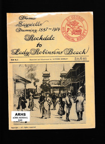 Victorian Railway History Library
Booklet, Eardley, Gifford, Thomas Saywells tramway 1887-1914 : Rockdale to Lady Robinsons Beach, 196-?
... Victorian Railway History Library 39 St Edmonds Rd Prahran Prahran Tramways - Sydney Tramways - St George district An illustrated description of theThomas Saywells tramway 1887-1914 : Rockdale to Lady Robinsons Beach in the southern suburbs of Sydney. ...An illustrated description of theThomas Saywells tramway 1887-1914 : Rockdale to Lady Robinsons Beach in the southern suburbs of Sydney.Ill, maps, p.20.non-fictionAn illustrated description of theThomas Saywells tramway 1887-1914 : Rockdale to Lady Robinsons Beach in the southern suburbs of Sydney.tramways - sydney, tramways - st george district -
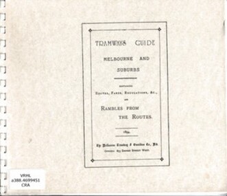 Victorian Railway History Library
Book, Jack Cranston, Tramways guide: Melbourne and suburbs containing routes, fares, regulations and rambles from the routes, 1894
... Victorian Railway History Library 39 St Edmonds Rd Prahran Prahran Urban transportation - Melbourne Cable trams - Melbourne Reprint of an 1894 guide with Illustrations, routes, descriptions and plans of Melbourne's cable trams 1885-1940. facsimile, Ill, maps, p.41. Tramways guide: Melbourne and suburbs ...Reprint of an 1894 guide with Illustrations, routes, descriptions and plans of Melbourne's cable trams 1885-1940.facsimile, Ill, maps, p.41.non-fictionReprint of an 1894 guide with Illustrations, routes, descriptions and plans of Melbourne's cable trams 1885-1940.urban transportation - melbourne, cable trams - melbourne -
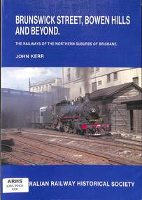 Victorian Railway History Library
Book, Kerr, John, Brunswick Street, Bowen Hills and Beyond, 1988
... Victorian Railway History Library 39 St Edmonds Rd Prahran Prahran Railroad operations - Queensland - history Railroad construction - Queensland - history A history of the railways in the northern suburbs of Brisbane in Queensland. index, ill, p.128. ...A history of the railways in the northern suburbs of Brisbane in Queensland.index, ill, p.128.non-fictionA history of the railways in the northern suburbs of Brisbane in Queensland.railroad operations - queensland - history, railroad construction - queensland - history -
 Victorian Railway History Library
Book, Webber, Brian, Rail Enthusiasts Guide to South East Brisbane, 1994
... Victorian Railway History Library 39 St Edmonds Rd Prahran Prahran Railroad operations - Queensland - history Railroads - Queensland - history A guide to railway locations for railway enthusiasts visiting the south eastern suburbs of Brisbane & the Gold Coast in Queensland. ill, maps, p.80. ...A guide to railway locations for railway enthusiasts visiting the south eastern suburbs of Brisbane & the Gold Coast in Queensland.ill, maps, p.80.non-fictionA guide to railway locations for railway enthusiasts visiting the south eastern suburbs of Brisbane & the Gold Coast in Queensland.railroad operations - queensland - history, railroads - queensland - history -
 Victorian Railway History Library
Book, Fiddian, Marc, By Meadows Broad and Narrow, 2020
... Victorian Railway History Library 39 St Edmonds Rd Prahran Prahran Railroad construction - Victoria - history Craigieburn - railway - history A history of the Craigieburn railway in the Northern suburbs of Melbourne. index, ill, p.98. ...A history of the Craigieburn railway in the Northern suburbs of Melbourne.index, ill, p.98.non-fictionA history of the Craigieburn railway in the Northern suburbs of Melbourne.railroad construction - victoria - history, craigieburn - railway - history -
 Victorian Railway History Library
Book, Fiddian, Marc, By Hill and By Vale, 2012
... Victorian Railway History Library 39 St Edmonds Rd Prahran Prahran Railroad construction - Victoria - history Hurstbridge - railway - history A history of the Hurstbridge railway in the north east suburbs of Melbourne. index, ill, p.82. ...A history of the Hurstbridge railway in the north east suburbs of Melbourne.index, ill, p.82.non-fictionA history of the Hurstbridge railway in the north east suburbs of Melbourne.railroad construction - victoria - history, hurstbridge - railway - history -
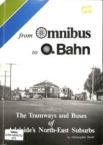 Victorian Railway History Library
Book, Steele, Christopher, From Omnibus to O-Bahn: The Tramways and Buses of Adelaide's North-East Suburbs, 1986
... Victorian Railway History Library 39 St Edmonds Rd Prahran Prahran Tramways -- South Australia -- Adelaide Metropolitan Area -- History Bus lines -- South Australia -- Adelaide Metropolitan Area (S.A.) -- History A history of the tramways and buses of the North-east suburbs in Adelaide, including diesel buses, trolley buses and the O-bahn express busway. ill, maps, p.127. ...A history of the tramways and buses of the North-east suburbs in Adelaide, including diesel buses, trolley buses and the O-bahn express busway.ill, maps, p.127.non-fictionA history of the tramways and buses of the North-east suburbs in Adelaide, including diesel buses, trolley buses and the O-bahn express busway.tramways -- south australia -- adelaide metropolitan area -- history, bus lines -- south australia -- adelaide metropolitan area (s.a.) -- history -
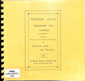 Victorian Railway History Library
Book, Jack Cranston, Tramways guide: Melbourne and suburbs containing routes, fares, regulations and rambles from the routes. Revised, 1894
... Victorian Railway History Library 39 St Edmonds Rd Prahran Prahran Urban transportation - Melbourne Cable trams - Melbourne Reprint of an 1894 guide with Illustrations, routes, descriptions and plans of Melbourne's cable trams 1885-1940. facsimile, Ill, maps, p.41. Tramways guide: Melbourne and suburbs ...Reprint of an 1894 guide with Illustrations, routes, descriptions and plans of Melbourne's cable trams 1885-1940.facsimile, Ill, maps, p.41.non-fictionReprint of an 1894 guide with Illustrations, routes, descriptions and plans of Melbourne's cable trams 1885-1940.urban transportation - melbourne, cable trams - melbourne