Showing 147 items matching "victorian water supply"
-
 Clunes Museum
Document - ARCHITECTURAL DRAWINGS, VICTORIAN WATER SUPPLY DEPARTMENT, CLUNES WATER SUPPLY, 9TH JULY 1870
... VICTORIAN WATER SUPPLY DEPARTMENT...WATER SUPPLY DRAWINGS AQUEDUCT DRAWINGS, CLUNES WATER SUPPLY. DRAWING No 11, CONTRACT No 2. SHOWING AQUEDUCT WORKS, UPPER AQUEDUCT CLUNES WATER SUPPLY Document ARCHITECTURAL DRAWINGS VICTORIAN WATER SUPPLY DEPARTMENT ...DRAWINGS, CLUNES WATER SUPPLY. DRAWING No 11, CONTRACT No 2. SHOWING AQUEDUCT WORKS, UPPER AQUEDUCTclunes, water supply, drawings, aqueduct -
 Federation University Historical Collection
Document - correspondence, Victorian Department of Mines & Water Supply to Ballarat School of Mines
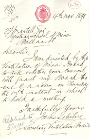
... Victorian Department of Mines & Water Supply to Ballarat School of Mines...A handwritten letter on Victorian Department of Mines & Water Supply letterhead (red logo). ...Faithfully Yours James Milne Secretary Venitlation Board Victorian Department of Mines & Water Supply to Ballarat School of Mines Document - correspondence James Milne ...Lecturer at the Ballarat School of Mines, Prof. Alfred Mica Smith, was highly involved with a report commissioned by the Venitilation of Mines Board in 1898.A handwritten letter on Victorian Department of Mines & Water Supply letterhead (red logo). The letter reads: 4th Nov. 1898 F.J. Martell Esq Registrar School of Mines Ballaarat Dear Sir, I am directed by the Ventilation of Mines Board to ask whether your Council will grant my Board the use of a room on Thursday the 17th instant in which to hold a meeting. Faithfully Yours James Milne Secretary Venitlation BoardIn a red circle "639" At lower left "Replied to 5/11/98mining, ballarat school of mines, alfred mica smith, mines, venitlation, james milne -
 Bendigo Historical Society Inc.
Map - LONG GULLY HISTORY GROUP COLLECTION: MAP OF LONG GULLY AREA
... ... Victorian Water Supply Reserve...History House 11 Mackenzie Street Bendigo goldfields BHS Collection BENDIGO History long gully history group The Long Gully History Group - Map of Long Gully Area Victorian Water Supply Reserve Borough of Eaglehawk Two copies of a map, printed on yellow paper, of the Long Gully Area. ...BHS CollectionTwo copies of a map, printed on yellow paper, of the Long Gully Area. It shows Eaglehawk Road from Barnard Street to a little past William Street.bendigo, history, long gully history group, the long gully history group - map of long gully area, victorian water supply reserve, borough of eaglehawk -
Tatura Irrigation & Wartime Camps Museum
Folder, Water Conference and Deputation to the Premier 1885, 1885
... victorian water supply...Tatura Irrigation & Wartime Camps Museum 49 Hogan Street Tatura the-murray Water conference and deputation to the Premier asking to assist the Goulburn Valley to construct a weir victorian water supply book history local Large black folder containing submissions to the Premier, Mr. ...Water conference and deputation to the Premier asking to assist the Goulburn Valley to construct a weirLarge black folder containing submissions to the Premier, Mr. Service, requesting funds to build water storagesvictorian water supply, book, history, local -
Bendigo Historical Society Inc.
Map - HARCOURT : COUNTY OF BENDIGO, 23-3-10
... Victorian Water Supply Reserve, Mt. Alexander State Forest. ...Victorian Water Supply Reserve, Mt. Alexander State Forest. ...Map. County of Bendigo, County of Talbot, Sutton Grange, Ravenswood, Walmer, Faraday, Castlemaine, Axe Creek, Barkers Creek, Melbourne to Echuca Railway, Victorian Water Supply in Connection with Barkers Creek Reservoir. Victorian Water Supply Reserve, Mt. Alexander State Forest. Three areas reserved for Sericulture (Silkworms). Photo-Lithographed at the Dept. of Lands and Survey, Melbourne by T.F. McGauran 23-3-10. Price 1/-. (number 101 in map cupboard 1)T.F. McGauranmap, bendigo, harcourt -
Tatura Irrigation & Wartime Camps Museum
Photograph, Stuart Murray Canal Sign, 1890s
... Sign:-"STATE RIVERS AND WATER SUPPLY COMMISSION/GOULBURN IRRIGATION SYSTEM/STUART MURRAY CANAL/CONVEYS WATER FROM GOULBURN WEIR TO WARANGA RESERVOIR/DESIGNED AND CONSTRUCTED BY VICTORIAN WATER SUPPLY DEPARTMENT - 1981....Sign:-"STATE RIVERS AND WATER SUPPLY COMMISSION/GOULBURN IRRIGATION SYSTEM/STUART MURRAY CANAL/CONVEYS WATER FROM GOULBURN WEIR TO WARANGA RESERVOIR/DESIGNED AND CONSTRUCTED BY VICTORIAN WATER SUPPLY DEPARTMENT - 1981. ...Taken by photographer for State Rivers and Water Supply Commission.Medium sized black and white photograph. Sign:-"STATE RIVERS AND WATER SUPPLY COMMISSION/GOULBURN IRRIGATION SYSTEM/STUART MURRAY CANAL/CONVEYS WATER FROM GOULBURN WEIR TO WARANGA RESERVOIR/DESIGNED AND CONSTRUCTED BY VICTORIAN WATER SUPPLY DEPARTMENT - 1981./STUART MURRAY M.I.C.E CHIEF ENGINEER."goulburn weir, victorian state rivers and supply commission -
 Federation University Historical Collection
Book, Victorian Government Legislative Assembly, The Select Committee on Castlemaine and Sandhurst water supply, Report from the Select Committee on Castlemaine and Sandhurst Water Supply, together with the proceedings of the Committee, minutes of evidence and appendices, 19/5/1865 (exact)
... water supply; with the proceedings of the committee, minutes of evidence and appendices. It also contains the report Of the Engineer-In-Chief of Railways, and reply of the Chief Engineer of Water Supply on the works constructed by the Victorian Water Supply Department, presented to both houses of parliament by His Excellency’s command. ...Water Supply Reports" is engraved in gold on spine. It includes a table showing the monthly and yearly rainfall and shade temperature at Ballarat, 2nd February, 1885. It also includes two reports and two replies, a map No.7082.2 of Victorian...Victorian Government Legislative Assembly, The Select Committee on Castlemaine and Sandhurst water supply...Water Supply Reports" is engraved in gold on spine. It includes a table showing the monthly and yearly rainfall and shade temperature at Ballarat, 2nd February, 1885. It also includes two reports and two replies, a map No.7082.2 of Victorian ...This book contains the report from the select committee on Castlemaine and Sandhurst water supply; with the proceedings of the committee, minutes of evidence and appendices. It also contains the report Of the Engineer-In-Chief of Railways, and reply of the Chief Engineer of Water Supply on the works constructed by the Victorian Water Supply Department, presented to both houses of parliament by His Excellency’s command. Ferdinand M. Krause, was a lecturer at the Ballarat School of Mines in Geology Mineralogy Mining Engineering and Surveying. He was a Fellow of the Geological Society and a Fellow of the Linnian Society. He was assistant engineer for the Ballaarat and Ballarat East Water Supply Committee and helped plan local reservoirs.A brown cloth hard cover, foolscap book with leather spine. Title is written in black on the title page. "Water Supply Reports" is engraved in gold on spine. It includes a table showing the monthly and yearly rainfall and shade temperature at Ballarat, 2nd February, 1885. It also includes two reports and two replies, a map No.7082.2 of Victorian Water Supply, Castlemaine and Sandhurst district general plan including lines of Aqueduct, Reservoirs. No. 7082.3 of Victorian Mining districts, Mining Divisions and The Gold Fields in 1866 - includes districts to be supplied under the Waterworks Act, 1965. It also includes: *Report of the Engineer-in-chief of Railways and Reply of the Chief Engineer of Water Supply on the works constructed by the Victorian Water Supply Department, 1869. * Coliban Water Scheme, 1864 * Ballarat and Ballarat East Water Supply (1869) including the Ballarat Water Supply List containing names of occupiers and nature of improvements on lands comprised within the proposed reserve of Gong Gong Reservoir, Ballaarat. At Warrenheip the names included: Honora McCallin, William Honan, C. McMahon, Patrick McMahon, J.P. Beach, J.H. Smith, Michael Nestor, Martin Quinn, Martin McIntyre, Robert Higgins, Coleman Kane, Robert Bond. At Ballarat: William Clarke, Richard White, John Hosking, Wesleyan Chapel, J. Hewitt, Robert McRobinson. At Bungaree: John Pullin, John Llewellyn. William Daw, Smith and Wynne, William Brough, A. Alexander. * Ballarat and Ballaarat East Water Supply report upon the advisability, or otherwise, of constructing a reservoir at the junction of the Yarrowee Creek and Gile's Creek, upon a site known as Gile's Reservoir (printed by Frank Pinkerton). This report has numerous notes written on it (most probably by Krause) and includes the capacity of Harry Beale's Reservoir, Pimcott's Reservoir and the Proposed Gong Gong Reservoir. * Statement as to the position of the Ballaarat and Ballaarat East Borough Councils in Connection with Water Supply, September 1869. * Ballarat and Ballaarat East Water Supply - General Statement upon the Ballaarat and Ballaarat east Scheme of Water Supply. Includes information on Moorabool reservoir, Harry Beale's Reservoir, Lal Lal Creek, Two Mile Creek, Beale's Dam, Yarrowee Creek, Gong Gong Reservoir, Kirk's Dam, Devil's Creek, Moorabool Creek. Additional handwritten notes (probably by Krause) * Engineer's Report on the resolution of the COmmittee of Water Supply, of the 7th July 1868. The report refers to the Country around Mount Warrenheip. Names mentioned are L. Abraham, Great North-West Gold Mining Company, Border Sawmills, Ferdinand Krause, Ohlfsen Bagge, W.H. Shaw, A signature by "Ferdinand M. Krause" at the top corner of the title page. A few pages have handwriting on the margins, it is believed to be his handwriting. water supply victoria, castlemaine directories, sandhurst directories, ballarat directories, james blackburn, edward wardle, daylesford water race, c j taylor, george avery fletcher, bagge, ohlfsen bagge, george foote, john h reilly, ambrose johnson, george francis, timber preservation, james forbes, alfred surplice, malcolm carmichael, robert adams, frederick hugh thomas, h o christerpherson, william downe, thomas lawrence brown, francis hadgson nixon, strangways, guildford, maldon, muckleford, lauriston, malmesbury, franklinford, walmer, strathloddon, downe, ferdinand krause, m7082, trentham, castlemaine, drummond, metcalfe, sutton grange, lockwood, ravenswood, mandurang, yandoit, c.h. ohlfsen bagge, moorabool reservoir, gong gong reservoir, harry beale's reservoir, pincott reservoir, frank pinkerton, water -
Tatura Irrigation & Wartime Camps Museum
Photograph, Goulburn Weir Sign, 1970s
... Sign describing Goulburn Weir - "State rivers and Water Supply Commission/Goulburn Weir/Diversion Headworks for Goulburn Irrigation System/Designed and Constructed by Victorian Water Supply Department 1891....Sign describing Goulburn Weir - "State rivers and Water Supply Commission/Goulburn Weir/Diversion Headworks for Goulburn Irrigation System/Designed and Constructed by Victorian Water Supply Department 1891. ...Taken by photographer for State Rivers and Water Supply Commission.Medium sized black and white photograph. Sign describing Goulburn Weir - "State rivers and Water Supply Commission/Goulburn Weir/Diversion Headworks for Goulburn Irrigation System/Designed and Constructed by Victorian Water Supply Department 1891./Full Supply Level is 408 Feet Above Sea Level/Stuart Murray M.I.C.E Chief Engineer/William Henderson A.M.I.C.E Supervising Engineer."goulburn weir, victorian state rivers and supply commission -
Bendigo Historical Society Inc.
Map - SUTTON GRANGE : COUNTY OF BENDIGO, 21-7-22
... Myrtle Creek. Victorian Water Supply - Main Line of Aquaduct from Malmsbury to Sandhurst. ...Myrtle Creek. Victorian Water Supply - Main Line of Aquaduct from Malmsbury to Sandhurst. ...Map. Sutton Grange, County of Bendigo, County of Talbot, Mandurang, Sedgwick, Ravenswood, Hawkestone, Harcourt, Faraday. Myrtle Creek. Victorian Water Supply - Main Line of Aquaduct from Malmsbury to Sandhurst. By authority A.J. Mullett, Government Printer, Melbourne. Photo-Lithographed at the Department of Lands and Survey, Melbourne by W.J. Butson, 21-7-22. Price 1/-. (number 125 in map cupboard 1)A.J. Mullett, Government Printer, Melbourne.map, bendigo, sutton grange -
Bendigo Historical Society Inc.
Map - SUTTON GRANGE : COUNTY OF BENDIGO, 21-7-22
... Sutton Grange, County of Bendigo, County of Talbot, Mandurang, Ravenswood, Harcourt, Faraday, Hawkestone, Lyell, Sedgwick, Myrtle Creek, Victorian Water Supply - Main Line of Aquaduct from Malmsbury to Sandhurst. ...Sutton Grange, County of Bendigo, County of Talbot, Mandurang, Ravenswood, Harcourt, Faraday, Hawkestone, Lyell, Sedgwick, Myrtle Creek, Victorian Water Supply - Main Line of Aquaduct from Malmsbury to Sandhurst. ...Map. Sutton Grange, County of Bendigo, County of Talbot, Mandurang, Ravenswood, Harcourt, Faraday, Hawkestone, Lyell, Sedgwick, Myrtle Creek, Victorian Water Supply - Main Line of Aquaduct from Malmsbury to Sandhurst. By authority A.J. Mullett, Government Printer, Melbourne. Photo-Lithographed at the Department of Lands and Survey, Melbourne by W.J. Butson 21-7-22. Price 1/-. (number 124 in map cupboard 1)A.J. Mullett, Government Printer, Melbourne.map, bendigo, sutton grange -
Bendigo Historical Society Inc.
Map - HARCOURT : COUNTY OF BENDIGO, December 1951
... Harcourt, County of Bendigo, County of Talbot, Town of Harcourt, Walmer, Sutton Grange, Ravenswood, Victorian Water Supply Reservoir, in connection with Barkers Creek Reservoir, Barkers Creek, Calder Highway, Northern Railway, Axe Creek. ...Harcourt, County of Bendigo, County of Talbot, Town of Harcourt, Walmer, Sutton Grange, Ravenswood, Victorian Water Supply Reservoir, in connection with Barkers Creek Reservoir, Barkers Creek, Calder Highway, Northern Railway, Axe Creek. ...Map. Harcourt, County of Bendigo, County of Talbot, Town of Harcourt, Walmer, Sutton Grange, Ravenswood, Victorian Water Supply Reservoir, in connection with Barkers Creek Reservoir, Barkers Creek, Calder Highway, Northern Railway, Axe Creek. By authority J.J. Gourley, Government Printer, Melbourne. Drawn and reproduced at the Department of Lands and Survey, Melbourne. December 1951. Price 5/- per sheet. (number 100 in map cupboard 1)J.J. Gourley, Government Printer, Melbourne.map, bendigo, harcourt -
Bendigo Historical Society Inc.
Map - HARCOURT : COUNTY OF BENDIGO, December 1951
... Sutton Grange, Walmer, Castlemaine, Faraday, Calder Highway, Northern Railway, Town of Harcourt, Barkers Creek, Victorian Water Supply Res., in connection with Barkers Creek Reservoir. ...Sutton Grange, Walmer, Castlemaine, Faraday, Calder Highway, Northern Railway, Town of Harcourt, Barkers Creek, Victorian Water Supply Res., in connection with Barkers Creek Reservoir. ...Map. Harcourt, County of Bendigo, County of Talbot, Ravenswood. Sutton Grange, Walmer, Castlemaine, Faraday, Calder Highway, Northern Railway, Town of Harcourt, Barkers Creek, Victorian Water Supply Res., in connection with Barkers Creek Reservoir. By authority J.J. Gourley, Government Printer, Melbourne .Drawn and reproduced at the Department of Lands and Survey, Melbourne. December 1951. Price 2/- per sheet. (number 96 in map cupboard 1)J.J. Gourley, Government Printer, Melbourne.map, bendigo, harcourt -
Tatura Irrigation & Wartime Camps Museum
Photograph, Alan Whiting, 1924
... ...victorian state rivers and water supply commission...Taken for the Victorian State Rivers and Water Supply Commission....Tatura Irrigation & Wartime Camps Museum 49 Hogan Street Tatura the-murray Taken for the Victorian State Rivers and Water Supply Commission. irrigation victorian state rivers and water supply commission waranga basin Mounted medium sized black and white photograph. ...Taken for the Victorian State Rivers and Water Supply Commission.Mounted medium sized black and white photograph. Waranga Basin, 1924 / Borrow pits filled with water / Clusters of huts and sheds / Trees on horizonirrigation, victorian state rivers and water supply commission, waranga basin -
Tatura Irrigation & Wartime Camps Museum
Photograph, Alan Whiting, 1924
... ...victorian state rivers and water supply commission...Taken for the Victorian State Rivers and Water Supply Commission....Tatura Irrigation & Wartime Camps Museum 49 Hogan Street Tatura the-murray Taken for the Victorian State Rivers and Water Supply Commission. irrigation victorian state rivers and water supply commission waranga basin Mounted medium sized black and white photograph. ...Taken for the Victorian State Rivers and Water Supply Commission.Mounted medium sized black and white photograph. Waranga Basin / Workmen pouring concrete for cutoff wall scaffolding across middle pictureirrigation, victorian state rivers and water supply commission, waranga basin -
Tatura Irrigation & Wartime Camps Museum
Photograph, Alan Whiting, 1924
... ...victorian state rivers and water supply commission...Taken for the Victorian State Rivers and Water Supply Commission....Tatura Irrigation & Wartime Camps Museum 49 Hogan Street Tatura the-murray Taken for the Victorian State Rivers and Water Supply Commission. irrigation victorian state rivers and water supply commission waranga basin Mounted medium sized black and white photograph. ...Taken for the Victorian State Rivers and Water Supply Commission.Mounted medium sized black and white photograph. Waranga Basin earth wall concrete reinforced (middle of picture) / Tree and hut near water filled borrow pits right centre.irrigation, victorian state rivers and water supply commission, waranga basin -
Tatura Irrigation & Wartime Camps Museum
Photograph, Alan Whiting, 1924
... ...victorian state rivers and water supply commission...Taken for the Victorian State Rivers and Water Supply Commission....Tatura Irrigation & Wartime Camps Museum 49 Hogan Street Tatura the-murray Taken for the Victorian State Rivers and Water Supply Commission. irrigation victorian state rivers and water supply commission waranga basin Mounted medium sized black and white photograph. ...Taken for the Victorian State Rivers and Water Supply Commission.Mounted medium sized black and white photograph. Waranga Basin inlet structure of concrete across water / Man on horseback centre of bridge / Rock wall bottom left corner.irrigation, victorian state rivers and water supply commission, waranga basin -
Tatura Irrigation & Wartime Camps Museum
Photograph, Alan Whiting, 1924
... ...victorian state rivers and water supply commission...Taken for the Victorian State Rivers and Water Supply Commission....Tatura Irrigation & Wartime Camps Museum 49 Hogan Street Tatura the-murray Taken for the Victorian State Rivers and Water Supply Commission. irrigation victorian state rivers and water supply commission waranga basin Mounted medium sized black and white photograph. ...Taken for the Victorian State Rivers and Water Supply Commission.Mounted medium sized black and white photograph. Waranga Basin inlet structure / Concrete sides mid-upper picture / channel and basin water filled / rock filled bank left of pictureirrigation, victorian state rivers and water supply commission, waranga basin -
Tatura Irrigation & Wartime Camps Museum
Photograph, Alan Whiting, 1924
... ...victorian state rivers and water supply commission...Taken for the Victorian State Rivers and Water Supply Commission....Tatura Irrigation & Wartime Camps Museum 49 Hogan Street Tatura the-murray Taken for the Victorian State Rivers and Water Supply Commission. irrigation victorian state rivers and water supply commission waranga basin Mounted medium sized black and white photograph. ...Taken for the Victorian State Rivers and Water Supply Commission.Mounted medium sized black and white photograph. Waranga Basin outlet structure and regulator / Concrete arches and pylons / Steel handrails / Rock and earth fill walls either side of channel.irrigation, victorian state rivers and water supply commission, waranga basin -
 Flagstaff Hill Maritime Museum and Village
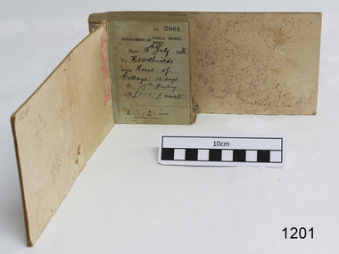
Financial record - Receipt Book, Department of Works and Mines Victoria, July 1936 (first record)
... Water Supply. For a brief period from 1891 to 1893 the Department of Mines was also responsible for forests and, until 1880, for the Schools of Mines subsequently transferred to the Education Department. In 1895 the Department of Mines and the Victorian...Water Supply. For a brief period from 1891 to 1893 the Department of Mines was also responsible for forests and, until 1880, for the Schools of Mines subsequently transferred to the Education Department. In 1895 the Department of Mines and the Victorian ...Establishment and Functions Prior to 1860, the Chief Secretary's Department had been responsible for the administration of the gold fields and associated mining activities. In November 1860 a Commissioner of Mines was appointed and a Department was established under his administration. For the period November 1861 to June 1863, the Postmaster General was responsible for the Mining Department. A Minister of Mines was again appointed in 1863. Responsibilities of the Department of Mines were: 1. Regulation of mining and related public works activities through the issue of miners rights, business and residence licences, mining leases, mineral and other prospecting licences 2. Superintendence of the activities of mining surveyors, registrars, wardens and Mining Boards. 3. Investigation of the state's geological structure, mineral wealth and underground water resources 4. Development of the mining industry 5. Supervision of the safe working of mines, machinery and quarries including checking the credential of mine managers, inspectors and operators 6. Regulation of the disposal of sludge and other waste products 7. Administration of the Victorian Mining Accident Relief Fund. Arising from its initial responsibility for the supply of water on the gold fields, the Department became responsible for rural water supply from the mid 1860s. Statutory responsibility for rural water works during this period rested with the Board of Land and Works. In 1865 the Waterworks Act gave the Board power to construct waterworks, purchase land, levy charges and lease or sell works, while the Public Loans Act 1865 empowered it to provide loans to local water trusts for waterworks. The actual administration of these statutory provisions was undertaken by the Victorian Water Supply Department which operated from 1865 to 1889 as a sub-department of the Department of Mines, from 1889 as a department in its own right, and from 1895 to 1909 as a sub-department of the Department of Mines and Water Supply. For a brief period from 1891 to 1893 the Department of Mines was also responsible for forests and, until 1880, for the Schools of Mines subsequently transferred to the Education Department. In 1895 the Department of Mines and the Victorian Water Supply Department were amalgamated to form the Department of Mines and Water Supply. A snapshot into social history around the 1930s when the Department of works and the Mines Departments were still linkedReceipt Book for the Department of Works; Mines. Receipt No 2801 - 3000. 1st receipt Number 2801, "18th July 1936, for Rent of Cottage: 14 days for 2 pounds, 2 shillings. The inscription on the back is signed by J F Condau in 13-3-33Printed on spine "GENERAL RECEIPTS / 15 / 2801 / TO 3000" Printed on each receipt 'DEPARTMENT OF / PUBLIC WORKS. / MINES." Fill in using ink pen "(DATE) 18th July 1936 / (TO) - - - shields' / BEING) Rent of / Cottage: 14 days / (TO) 17th July / @ (symbol for pound) 1-1. p. week / . (symbol for pound) 2:2:-"Inside cover there is some red pencil writing, words and figures unreadable. Handwritten on back cover "Numbers checked / and found corredt / J S Coudou (?) / 13-3-33" One some receipts "Wharfage / S.S. Koonara"flagstaff hill, warrnambool, shipwrecked coast, flagstaff hill maritime museum, maritime museum, shipwreck coast, flagstaff hill maritime village, great ocean road, department of works: mines, receipt book, rent 1936, imperial currency, living costs 1936, department of works, department of mines, j f condou, 1933, 13-3-33 -
Federation University Historical Collection
Book - Municipal Directory, Arnall & Jackson Pty Ltd, Victorian Municipal Directory 1970, 1970
... Red hard cover book which is a state guide to Victorian municipal councils and water supply record. It incorporates part of Southern New South Wales. ...Barker Library (top floor) Mount Helen goldfields This book was issued to Brian William Schreenan who completed his Civil Engineering Degree at the School of Mines from 1949-1953. municipal directory council towns water supply sewerage members of parliament alumni Red hard cover book which is a state guide to Victorian municipal councils and water supply record. ...Red hard cover book which is a state guide to Victorian municipal councils and water supply record. It incorporates part of Southern New South Wales. The directory lists the areas that make up the municipality, the names of councillors and officers, and gives descriptions of towns and cities. Lists of parliamentary departments and officers are also included. non-fictionmunicipal directory, council, towns, water supply, sewerage, members of parliament, alumni -
Federation University Historical Collection
Book - Municipal Directory, Arnall & Jackson Pty Ltd, Victorian Municipal Directory 1976, 1976
... Blue hard cover book which is a state guide to Victorian municipal councils and water supply record. It incorporates part of Southern New South Wales. ...Barker Library (top floor) Mount Helen goldfields This book was issued to Brian William Schreenan who completed his Civil Engineering Degree at the School of Mines from 1949-1953. municipal directory council towns water supply sewerage members of parliament alumni Blue hard cover book which is a state guide to Victorian municipal councils and water supply record. ...Blue hard cover book which is a state guide to Victorian municipal councils and water supply record. It incorporates part of Southern New South Wales. The directory lists the areas that make up the municipality, the names of councillors and officers, and gives descriptions of towns and cities. Lists of parliamentary departments and officers are also included. non-fictionmunicipal directory, council, towns, water supply, sewerage, members of parliament, alumni -
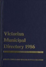 Federation University Historical Collection
Book - Municipal Directory, Arnall & Jackson Pty Ltd, Victorian Municipal Directory 1986, 1986
... Blue hard cover book which is a state guide to Victorian municipal councils and water supply record. It incorporates part of Southern New South Wales. ...Barker Library (top floor) Mount Helen goldfields This book was issued to Brian William Schreenan who completed his Civil Engineering Degree at the School of Mines from 1949-1953. municipal directory council towns water supply sewerage members of parliament alumni brian schreenan Blue hard cover book which is a state guide to Victorian municipal councils and water supply record. ...Blue hard cover book which is a state guide to Victorian municipal councils and water supply record. It incorporates part of Southern New South Wales. The directory lists the areas that make up the municipality, the names of councillors and officers, and gives descriptions of towns and cities. Lists of parliamentary departments and officers are also included. non-fictionmunicipal directory, council, towns, water supply, sewerage, members of parliament, alumni, brian schreenan -
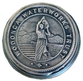 Wodonga & District Historical Society Inc
Functional object - Official Seal of the Wodonga Waterworks Trust
... water supply to Wodonga. This included focus on the water quality which had often been a problem. After lobbying the Victorian Department of Water Supply for several years, the first official meeting of the officially constituted Wodonga Waterworks Trust was held on Wednesday 20th October 1897. ...water supply to Wodonga. This included focus on the water quality which had often been a problem. After lobbying the Victorian Department of Water Supply for several years, the first official meeting of the officially constituted Wodonga Waterworks Trust was held on Wednesday 20th October 1897. ...The Wodonga Waterworks Trust was established in 1897 to control and improve water supply to Wodonga. This included focus on the water quality which had often been a problem. After lobbying the Victorian Department of Water Supply for several years, the first official meeting of the officially constituted Wodonga Waterworks Trust was held on Wednesday 20th October 1897. The Board initially consisted of all Wodonga Shire Councillors together with Mr Samuel Mason Jr., as the nominee of the Government. Councillor McFarlane was appointed as the first Chairman. This Seal was used to endorse all official documents issued by the Trust. Documents placed between the two plates of the Seal would be embossed with the Trust’s emblem.This item is significant because it is representative of the first local government body constituted to improve water supply to Wodonga.A heavy metal seal machine used to make the imprint of the Wodonga Waterworks Trust. The seal is embossed on a circular disc. The imprint, which is not visible when assembled, shows an imprint of a woman in Grecian-style clothes carrying a water ewer on her shoulder.Around circular seal - WODONGA WATERWORKS TRUSTwodonga waterworks trust, water supply wodonga -
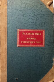 Wodonga & District Historical Society Inc
Financial record - Wodonga Waterworks Trust Balance Book
... water supply to Wodonga. This included focus on the water quality which had often been a problem. After lobbying the Victorian Department of Water Supply for several years, the first official meeting of the newly constituted Wodonga Waterworks Trust was held on Wednesday 20th October 1897. ...water supply to Wodonga. This included focus on the water quality which had often been a problem. After lobbying the Victorian Department of Water Supply for several years, the first official meeting of the newly constituted Wodonga Waterworks Trust was held on Wednesday 20th October 1897. ...Wodonga Waterworks Trust was established in 1897 to control and improve water supply to Wodonga. This included focus on the water quality which had often been a problem. After lobbying the Victorian Department of Water Supply for several years, the first official meeting of the newly constituted Wodonga Waterworks Trust was held on Wednesday 20th October 1897. The Board initially consisted of all Wodonga Shire Councillors, together with Mr Samuel Mason Jr., as the nominee of the Government. Councillor McFarlane was appointed as the first Chairman. This Record Book contains documentation of expenditure of the Wodonga Waterworks Trust from 1908 through to the early 1950s. This includes the official record of payments of £2,897/ 18 /- and £130 to contractor A. A. Hargrave for Erection of the Water Tower. Other payments related to the Water Tower include entries for pumps, gears, pipe laying, pipes, the pump station and related fittings. Construction of the Water Tower was completed in early 1924 and after thorough testing throughout that year, the completed new water system for Wodonga was officially opened on 4th December 1924.This item is significant because it contains financial records related to the construction of one of the oldest and most significant buildings in Wodonga.This large ledger contains both hand written and typed notes documenting financial reports of the Wodonga Water Trust over 40 years. The cover is dark green with brown binding. In the centre of the cover is an red rectangle with text and a border printed in gold.On front cover within gold border BALANCE RECORD WODONGA WATERWORKS TRUSTwodonga waterworks trust, wodonga water tower, a. a. hargrave -
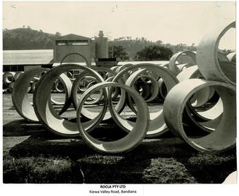 Wodonga & District Historical Society Inc
Photograph - ROCLA, Wodonga
... Another early major contract for ROCLA was with the Victorian State Rivers and Water Supply Commission for the provision of pipes for the new sewerage system in the new town of Tallangatta, relocated due to the enlargement of the Hume Weir. ...Another early major contract for ROCLA was with the Victorian State Rivers and Water Supply Commission for the provision of pipes for the new sewerage system in the new town of Tallangatta, relocated due to the enlargement of the Hume Weir. ...ROCLA was founded by two friends, Walter Robertson and Heaton Clarke, who combined the first letters of their surnames to create the brand name in 1922. The company first came to the Albury – Wodonga area in late 1927 when tenders were called for the construction of their works and office in Kiewa Street, Albury. They were a popular provider of concrete pipe culverts and reinforced concrete troughs for farm use. In 1949 ROCLA began operations at Bandiana. Initially this was to produce pipes for the Snowy Mountains Hydro-Electric Scheme which officially began construction on 17 October 1949. They also provided pipes for the Kiewa Hydro Scheme. Another early major contract for ROCLA was with the Victorian State Rivers and Water Supply Commission for the provision of pipes for the new sewerage system in the new town of Tallangatta, relocated due to the enlargement of the Hume Weir. This contract called for the supply of 21,000 six inch pipes and 7,000 nine inch pipes. At this time ROCLA employed 15 men and this job required about 80 bags of cement per day. By 1964 ROCLA Concrete Pipes was Wodonga’s largest secondary industry. A new concrete pole manufacturing plant was established in the early 1980s. ROCLA poles also dot the landscape in several Australian States. ROCLA poles also hold up many of the Hume Freeway bridge and support the Union Bridge which crosses the Murray River at Albury. After various changes in management, ROCLA was taken over by New Zealand's Fletcher Building group in 2005. In September 2021 ROCLA became part of the Civilmart Group. These images are significant because they record the history of a major manufacturing industry in Wodonga.A collection of photographs and advertisements representing the ROCLA, Wodonga company.manufacturing industries wodonga, rocla wodonga, wodonga industries -
 Warrnambool and District Historical Society Inc.
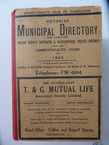
Book, Victorian Municipal Directory 1945, 1945
... This is a Victorian Municipal Directory for 1945, containing general information on all municipalities in Victoria, a Gazeteer, a Commonwealth Guide and a Water Supply Record. ...Warrnambool and District Historical Society Inc. 2 Gilles Street (south of Merri St) Warrnambool great-ocean-road This is a Victorian Municipal Directory for 1945, containing general information on all municipalities in Victoria, a Gazeteer, a Commonwealth Guide and a Water Supply Record. ...This is a Victorian Municipal Directory for 1945, containing general information on all municipalities in Victoria, a Gazeteer, a Commonwealth Guide and a Water Supply Record. Municipal Directories were published annually in Victoria from 1867 on. This directory came from the Shire of Mortlake which was established in 1864 when it had an area of 2137 square kilometres. The Shire of Mortlake was abolished in 1994 and merged with other neighbouring shires to form the present-day Shire of Moyne. This book is very useful to researchers as it contains much information on the City, Borough and Shire structures, the Council employees and Government employees of all the municipalities. It has, therefore, important local information on Warrnambool and the surrounding areas in 1945. This is a soft cover book of 1114 pages. It has a buff- coloured cover with red binding on the spine. The printed material on the covers is printed in black. It has a blue stamp of the Shire of Mortlake on several pages. The book contains several advertisements for Melbourne businesses. ‘Shire of Mortlake’ shire of mortlake, local government in victoria, warrnambool history -
 Kiewa Valley Historical Society
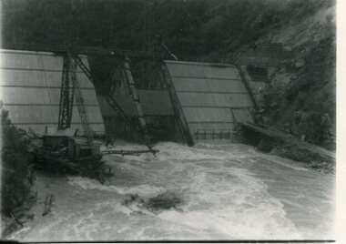
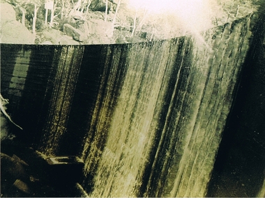
Photograph - Kiewa River in flood at Clover Dam
... supply, the Victorian Government (circa 1930) implemented the conversion strategy from mainly brown coal supply to hydro - electricity. The Kiewa Hydroelectric Scheme became the largest scheme of its kind in the State Of Victoria and the second largest scheme in Australia. Clover Dam and Power Station were built by the State Electricity Commission of Victoria as part of the Kiewa Hydro Electric Scheme from the late 1930's to the early 1940's. This dam was constructed to supply water...supply, the Victorian Government (circa 1930) implemented the conversion strategy from mainly brown coal supply to hydro - electricity. The Kiewa Hydroelectric Scheme became the largest scheme of its kind in the State Of Victoria and the second largest scheme in Australia. Clover Dam and Power Station were built by the State Electricity Commission of Victoria as part of the Kiewa Hydro Electric Scheme from the late 1930's to the early 1940's. This dam was constructed to supply water ...As part of the push to cut electricity costs and diversify supply, the Victorian Government (circa 1930) implemented the conversion strategy from mainly brown coal supply to hydro - electricity. The Kiewa Hydroelectric Scheme became the largest scheme of its kind in the State Of Victoria and the second largest scheme in Australia. Clover Dam and Power Station were built by the State Electricity Commission of Victoria as part of the Kiewa Hydro Electric Scheme from the late 1930's to the early 1940's. This dam was constructed to supply water to feed four turbines (62 mega watts) at the West Kiewa Power Station. This was at the forefront of sustainable "Green" energy. Costs associated with power supplies is still a major incentive of governments, however environmentally friendly alternatives such as wind and nuclear have also made inroads. The Kiewa valley and its surrounding alpine catchment were looked at(Victorian State Government), from the beginning of the twentieth century as a source of alternate power for an ever-increasing demand for electricity by growing population and heavy industrial areas within Melbourne City and State regions. Construction of dams, such as Clover Dam provided the large quantity holding areas of water required to turn the turbines at the various power stations to provide the electricity needed. The impact of these controls by moderating water run-off from the alpine regions is beneficial in reducing flooding from thawing of snow on the alps. This by-product allows agriculture and grazing to be less vulnerable to seasonal flooding thereby resulting in a more stable annual production level.Black and white photograph of Clover Dam with Kiewa River in flood. .5mm white boarder on 3 sides of photo.Handwritten on back of photograph in black pen - Kiewa in flood. Clover Dam.clover dam, secv -
 Kiewa Valley Historical Society
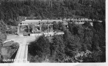
Photograph - Clover Dam
... supply, the Victorian Government (circa 1930) implemented the conversion strategy from mainly brown coal supply to hydro - electricity. The Kiewa Hydroelectric Scheme became the largest scheme of its kind in the State Of Victoria and the second largest scheme in Australia. Clover Dam and Power Station were built by the State Electricity Commission of Victoria as part of the Kiewa Hydro Electric Scheme from the late 1930's to the early 1940's. This dam was constructed to supply water...supply, the Victorian Government (circa 1930) implemented the conversion strategy from mainly brown coal supply to hydro - electricity. The Kiewa Hydroelectric Scheme became the largest scheme of its kind in the State Of Victoria and the second largest scheme in Australia. Clover Dam and Power Station were built by the State Electricity Commission of Victoria as part of the Kiewa Hydro Electric Scheme from the late 1930's to the early 1940's. This dam was constructed to supply water ...As part of the push to cut electricity costs and diversify supply, the Victorian Government (circa 1930) implemented the conversion strategy from mainly brown coal supply to hydro - electricity. The Kiewa Hydroelectric Scheme became the largest scheme of its kind in the State Of Victoria and the second largest scheme in Australia. Clover Dam and Power Station were built by the State Electricity Commission of Victoria as part of the Kiewa Hydro Electric Scheme from the late 1930's to the early 1940's. This dam was constructed to supply water to feed four turbines (62 mega watts) at the West Kiewa Power Station. This was at the forefront of sustainable "Green" energy. Costs associated with power supplies is still a major incentive of governments, however environmentally friendly alternatives such as wind and nuclear have also made inroads. The Kiewa valley and its surrounding alpine catchment were looked at(Victorian State Government), from the beginning of the twentieth century as a source of alternate power for an ever-increasing demand for electricity by growing population and heavy industrial areas within Melbourne City and State regions. Construction of dams, such as Clover Dam provided the large quantity holding areas of water required to turn the turbines at the various power stations to provide the electricity needed. The impact of these controls by moderating water run-off from the alpine regions is beneficial in reducing flooding from thawing of snow on the alps. This by-product allows agriculture and grazing to be less vulnerable to seasonal flooding thereby resulting in a more stable annual production level.Black and white photograph of Clover Dam buildings and Kiewa River. Has a .4cm white border around photograph Printed on bottom left corner of photograph in white - Clover Flatclover dam, secv -
 Kiewa Valley Historical Society
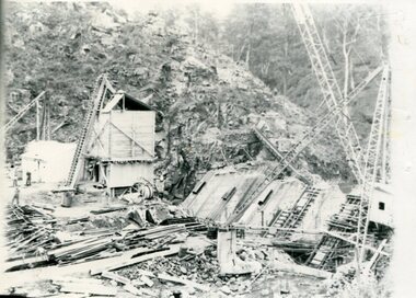
Photographs x 2 - Clover Dam, Circa 1940's
... supply, the Victorian Government (circa 1930) implemented the conversion strategy from mainly brown coal supply to hydro - electricity. The Kiewa Hydroelectric Scheme became the largest scheme of its kind in the State Of Victoria and the second largest scheme in Australia. Clover Dam and Power Station were built by the State Electricity Commission of Victoria as part of the Kiewa Hydro Electric Scheme from the late 1930's to the early 1940's. This dam was constructed to supply water...supply, the Victorian Government (circa 1930) implemented the conversion strategy from mainly brown coal supply to hydro - electricity. The Kiewa Hydroelectric Scheme became the largest scheme of its kind in the State Of Victoria and the second largest scheme in Australia. Clover Dam and Power Station were built by the State Electricity Commission of Victoria as part of the Kiewa Hydro Electric Scheme from the late 1930's to the early 1940's. This dam was constructed to supply water ...As part of the push to cut electricity costs and diversify supply, the Victorian Government (circa 1930) implemented the conversion strategy from mainly brown coal supply to hydro - electricity. The Kiewa Hydroelectric Scheme became the largest scheme of its kind in the State Of Victoria and the second largest scheme in Australia. Clover Dam and Power Station were built by the State Electricity Commission of Victoria as part of the Kiewa Hydro Electric Scheme from the late 1930's to the early 1940's. This dam was constructed to supply water to feed four turbines (62 mega watts) at the West Kiewa Power Station. This was at the forefront of sustainable "Green" energy. Costs associated with power supplies is still a major incentive of governments, however environmentally friendly alternatives such as wind and nuclear have also made inroads. The Kiewa valley and its surrounding alpine catchment were looked at(Victorian State Government), from the beginning of the twentieth century as a source of alternate power for an ever-increasing demand for electricity by growing population and heavy industrial areas within Melbourne City and State regions. Construction of dams, such as Clover Dam provided the large quantity holding areas of water required to turn the turbines at the various power stations to provide the electricity needed. The impact of these controls by moderating water run-off from the alpine regions is beneficial in reducing flooding from thawing of snow on the alps. This by-product allows agriculture and grazing to be less vulnerable to seasonal flooding thereby resulting in a more stable annual production level. Photographs also document early engineering and building techniques used in the construction of dams and power stations during the 1940’s and 1950’s. Note the lack of safety equipment and suitable work attire worn by construction workers on the sites 1. Black and white photograph of Clover Dam under construction. Has a .5cm white border around photo 2. Black and white photograph of Clover Dam under construction showing workmen at work. Has a .5cm white border around photo Written in pencil on back of both photographs - Clover Damclover dam, secv -
 Kiewa Valley Historical Society
Photograph Clover Dam, Clover Dam Circa 1940, circa 1940s to 1950s
... supply, the Victorian Government (circa 1930) implemented the conversion strategy from mainly brown coal supply to hydro - electricity. The Kiewa Hydroelectric Scheme became the largest scheme of its kind in the State Of Victoria and the second largest scheme in Australia. This dam was constructed to supply water...supply, the Victorian Government (circa 1930) implemented the conversion strategy from mainly brown coal supply to hydro - electricity. The Kiewa Hydroelectric Scheme became the largest scheme of its kind in the State Of Victoria and the second largest scheme in Australia. This dam was constructed to supply water ...As part of the push to cut electricity costs and diversify supply, the Victorian Government (circa 1930) implemented the conversion strategy from mainly brown coal supply to hydro - electricity. The Kiewa Hydroelectric Scheme became the largest scheme of its kind in the State Of Victoria and the second largest scheme in Australia. This dam was constructed to supply water to feed four turbines (62 mega watts) at the West Kiewa Power Station. This was at the forefront of sustainable "Green" energy. Costs associated with power supplies is still a major incentive of governments, however environmentally friendly alternatives such as wind and nuclear have also made inroads. The Kiewa valley and its surrounding alpine catchment were looked at(Victorian State Government), from the beginning of the twentieth century as a source of alternate power for an every increasing demand for electricity by growing population and heavy industrial ares within Melbourne City and State regions. Construction of dams, such as Clover Dam provided the large quantity holding areas of water required to turn the turbines at the various power stations to provide the electricity needed. The impact of these controls by moderating water run off from the alpine regions is beneficial in reducing flooding from thawing of snow on the alps. This by-product allows agriculture and grazing to be less vulnerable to seasonal flooding thereby resulting in a more stable annual production level.Reproduction (scanned) of a black and white photo of Clover Dam circa 1940. The paper used is KodakXtraLife II paperThe reverse side of photo " KodakXtraLife II paperdams, pondage, hydro electricity, power stations, clover dam, secv