Showing 120 items matching "vineyard road."
-
 Hume City Civic Collection
Photograph, c1960s
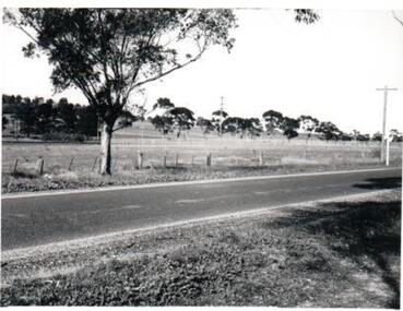
... Vineyard Road...The photograph overlooks former railway land along Vineyard Road which is now a commercial and light industrial estate. ...A black and white photograph of Vineyard Road with the Sunbury Railway line visible across the middle distance and the former Sunbury Asylum site in the background....Vineyard Road Sunbury Asylum Sunbury Railway Line George Evans Collection A black and white photograph of Vineyard Road with the Sunbury Railway line visible across the middle distance and the former Sunbury Asylum site in the background. ...The photograph overlooks former railway land along Vineyard Road which is now a commercial and light industrial estate. It was taken before curbing and footpaths were laid and Vineyard Road was narrow strip of asphalt with the sides of the road unmade.A black and white photograph of Vineyard Road with the Sunbury Railway line visible across the middle distance and the former Sunbury Asylum site in the background.vineyard road, sunbury asylum, sunbury railway line, george evans collection -
 Sunbury Family History and Heritage Society Inc.
Photograph, Rosa McCall, 2001
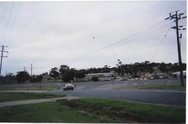
... ...Vineyard Road....The photograph was taken looking towards Jacksons Hill at the T intersection of Mitchells Lane and when Vineyard Road becomes Horne Street, before there was a lot of commercial development at that intersection and on Jacksons Hill....Jacksons Hill Mitchells Lane Vineyard Road. Horne Street Sunbury A coloured photograph of an intersection where a small car is waiting to go ahead. ...The photograph was taken looking towards Jacksons Hill at the T intersection of Mitchells Lane and when Vineyard Road becomes Horne Street, before there was a lot of commercial development at that intersection and on Jacksons Hill.A coloured photograph of an intersection where a small car is waiting to go ahead. Some cars are parked in an allotment outside building on the opposite side of the road.jacksons hill, mitchells lane, vineyard road., horne street, sunbury -
 Hume City Civic Collection
Photograph
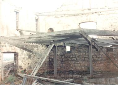
... ...vineyard road...Rosenthal Winery in Vineyard Road, Sunbury was one of the first wineries established in the area. ...Hume City Civic Collection 44 Macedon Street Sunbury melbourne Rosenthal Winery in Vineyard Road, Sunbury was one of the first wineries established in the area. ...Rosenthal Winery in Vineyard Road, Sunbury was one of the first wineries established in the area. It was owned by R. F. Kurrle. The roofless building still stands on the property which was part of the dairy farm owned by Tom and Angela Millett. The last vintage from the property was crushed in 1910.A coloured photograph of shell of the interior of the Rosenthal Winery. The bluestone is exposed on the lower half of the walls but the walls on the upper storey have either been rendered or painted. Part of the interior wooden structure is still standing. There is an open doorway on the LHS with two windows above it. Two smaller windows are on the lower part of another wall with a larger window above them. The building is roofless.rosenthal winery, wineries, vineyards, vineyard road, sunbury wineries, kurrle, r. f., millett, tom, angela, sunbury, george evans collection -
 Hume City Civic Collection
Photograph
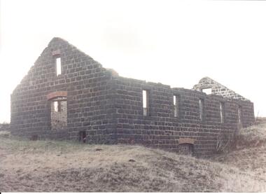
... ...vineyard road...Rosenthal Winery in Vineyard Road, Sunbury was one of the first wineries established in the area. ...Hume City Civic Collection 44 Macedon Street Sunbury melbourne Rosenthal Winery in Vineyard Road, Sunbury was one of the first wineries established in the area. ...Rosenthal Winery in Vineyard Road, Sunbury was one of the first wineries established in the area. It was owned by R. F. Kurrle. The roofless building still stands on the property which was part of the dairy farm owned by Tom and Angela Millett. The last vintage from the property was crushed in 1910.A view of the exterior of the ruins of Rosenthal Winery showing 2 sides. It is a bluestone building with a red brick arched doorway at the front and a small narrow arched window above the doorway. Along the side there is another arched doorway at the lower level and 5 paneless windows along the upper level. The pitched gable ends are still standing but the building is roofless.rosenthal winery, wineries, vineyards, vineyard road, sunbury wineries, kurrle, r. f., millett, tom, angela, sunbury, george evans collection -
 Hume City Civic Collection
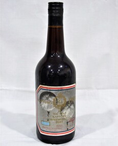
Container - Bottle - Wine, Digger's Rest Vineyard Pinot Noir 1994
... front label: Digger's Rest/VINEYARD/PINOT NOIR/Old Vineyard Road, Sunbury 3429......Digger's Rest Vineyard Wines Bottles Frank and Judy Hogan 1980s 1990s George Evans Collection front label: Digger's Rest/VINEYARD/PINOT NOIR/Old Vineyard Road, Sunbury 3429... Conventional green glass wine bottle with indented base. ...This wine bottle was donated by Frank and Judy Hogan for use in the exhibition 'A History of Vineyards in Sunbury' held at the George Evans Museum in 1996. The Digger's Rest Vineyard was planted in 1987. With the help of winemaker Peter Dredge in 1994 the Digger's Rest vineyard was awarded two medals at the Victorian Wine Show.Conventional green glass wine bottle with indented base. A gold, purple, white and black printed label on the front with a drawing of a gold digger on a log. a printed label. A printed label is on the back. There is a small foil label around top of neck of bottle. a gold and black stick on label with 1994 on the lower RH corner.front label: Digger's Rest/VINEYARD/PINOT NOIR/Old Vineyard Road, Sunbury 3429...digger's rest vineyard, wines, bottles, frank and judy hogan, 1980s, 1990s, george evans collection -
 Hume City Civic Collection
Photograph
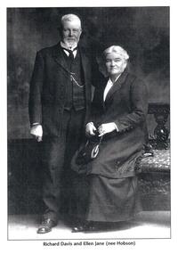
... This is a photograph of Richard Davis and his wife Ellen Jane nee Hobson who owned Winilba Vineyard in Vineyard Road, Sunbury....Hume City Civic Collection 44 Macedon Street Sunbury melbourne This is a photograph of Richard Davis and his wife Ellen Jane nee Hobson who owned Winilba Vineyard in Vineyard Road, Sunbury. vineyards winilba vineyard wineries vintners davis richard ellen jane nee hobson sue kevin george evans collection Written underneath the photograph: "Richard Davis and Ellen Jane nee Hobson" A black and white photograph of an elderly couple. ...This is a photograph of Richard Davis and his wife Ellen Jane nee Hobson who owned Winilba Vineyard in Vineyard Road, Sunbury.A black and white photograph of an elderly couple. The man is standing and the woman is seated.Written underneath the photograph: "Richard Davis and Ellen Jane nee Hobson"vineyards, winilba vineyard, wineries, vintners, davis, richard, ellen jane nee hobson, sue, kevin, george evans collection -
 Sunbury Family History and Heritage Society Inc.
Photograph, Sue Palmer, Landscape, March 2001
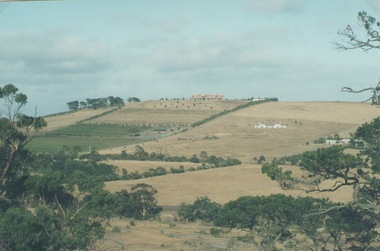
... The east facing slopes along Vineyard Road were suitable for vine growing as was the flats along Jacksons Creek....The east facing slopes along Vineyard Road were suitable for vine growing as was the flats along Jacksons Creek. ...The photograph was part of a collection from a photograph competition organised bye the Sunbury & District Heritage Association in March 2001. It is a view of the former vineyard growing area in Sunbury which was situated along Vineyard Road. One of the remaining vineyards is visible in the photo. From 1860 to the early 1900s many vineyards were operating in Sunbury. The east facing slopes along Vineyard Road were suitable for vine growing as was the flats along Jacksons Creek.A non-digital coloured landscape photograph of a hillside showing some cultivation and grazing land and three houses as well as some native trees. sunbury, vineyards, wine production -
 Hume City Civic Collection
Photograph, Schlossberg Vineyard, 1909
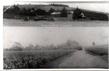
... Schlossberg Vineyard was situated along Vineyard Road in Sunbury, between Winilba and the Calder Highway. ...Hume City Civic Collection 44 Macedon Street Sunbury melbourne Schlossberg Vineyard was situated along Vineyard Road in Sunbury, between Winilba and the Calder Highway. ...Schlossberg Vineyard was situated along Vineyard Road in Sunbury, between Winilba and the Calder Highway. It was established by Felix Frederick Bubeck, who arrived in Australia from Rotenberg (near Stuggart) in the 1860. In 1866 he acquired 60 acres of land on Bald Hill and established the vineyard. In 1880, claret produced on the property received an honourable mention when it was exhibited in Bordeaux, France,From the mid 1850s a number of vineyards were established on the hillsides overlooking Vineyard Road. The east facing outlook that captured the morning sun was ideal for growing grapevines. Other vineyards were also established in the area at the same time.A black and white copy of a postcard of two photographs mounted on the one card with the original handwritten message photocopied on the back. To my dear brother & sister with love and good wishes for a Merry Xmas & a prosperous 1909. Thanks for the paper Your loving sister Marie. You will think it a good photo You will see the trees have grown almost hiding the house. Mr. A Senling, Cheetham St. Kalgoorlie Sth. WAfelix frederick bubeck, schlossberg vineyard, bald hill, vineyards -
 Greensborough Historical Society
Slide - Photograph, John Ramsdale, Vineyards off Bonds Road: Slide 66, 1990s
... Photograph shows a vineyard off Bonds Road Lower Plenty....Greensborough Historical Society 34A Glenauburn Road Lower Plenty Lower Plenty melbourne Photograph shows a vineyard off Bonds Road Lower Plenty. ...Photograph shows a vineyard off Bonds Road Lower Plenty.Part of the John Ramsdale collection of slides and audio visual material.Colour photograph scanned from slide.No maker's marks. No caption on slide.vineyards, bonds road lower plenty -
 Sunbury Family History and Heritage Society Inc.
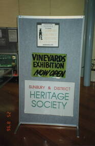
Photograph, Sunbury & District Heritage Association Inc, Vineyards Exhibition, August 1996
... From the early days of European settlement in Sunbury, it was found that the soils and climate suited the growing of grapes, especially the east facing slopes along Vineyard Road. A number of people of German origin established vineyards along there. ...From the early days of European settlement in Sunbury, it was found that the soils and climate suited the growing of grapes, especially the east facing slopes along Vineyard Road. A number of people of German origin established vineyards along there. ...The vineyards exhibition was mounted by the Sunbury & District Heritage Association in the former George Evans Museum from August 1996 to January 1997. It featured the establishment of the vineyards and the wine industry in Sunbury from the 1860s to the present day. From the early days of European settlement in Sunbury, it was found that the soils and climate suited the growing of grapes, especially the east facing slopes along Vineyard Road. A number of people of German origin established vineyards along there. By the end of the nineteenth century and limited spending power as a result of the 1890s depression, the demand for wine declined in Victoria with beer being the preferred beverage.While Phylloxera destroyed the vines in many areas of Victoria, Sunbury's grapevines were not affected. As the demand for wine increased in the 1960s - 70s, some vineyards in the Sunbury area were replanted.The vineyards established in Sunbury in the 1860s were one of the earliest agricultural pursuits taken up by European settlers in the area and remained an important industry for 40 years.A non-digital coloured photograph of a display board advertising an exhibition of vineyards in the Sunbury area.vineyards, sunbury, vignerons, wine production -
 Rutherglen Historical Society
Image, 1970s
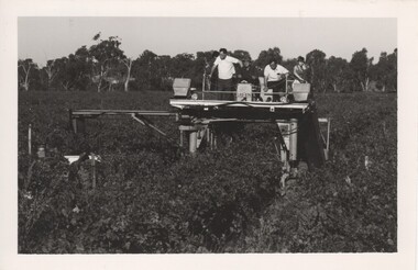
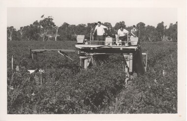
... It was operating in the B Seppelt & sons Distillery Road vineyards on the edge of the Murray River in Wahgunyah. ...It was operating in the B Seppelt & sons Distillery Road vineyards on the edge of the Murray River in Wahgunyah. ...This is a photo of one of the first upright machine grape harvesters operating in the Rutherglen area. It was operating in the B Seppelt & sons Distillery Road vineyards on the edge of the Murray River in Wahgunyah. Riding on the top of the machine are from left to right Mandy Jones (partly obscured), Rolly Guscot (vineyard manager), machine driver, Doug Jones (manager) and Leanne Schoen (nee Jones). Mandy Jones and Leanne Schoen being the daughters of Doug Jones )) Black and white photograph of several people riding on top of a machine operating in a vineyard.wineries, north east victoria, wine industry, mechanical harvester, grape harvester, rutherglen, seppelts winery, doug jones -
 Rutherglen Historical Society
Photograph - Image, 1970s
... It was operating in the B Seppelt & sons Distillery Road vineyards on the edge of the Murray River in Wahgunyah. ...It was operating in the B Seppelt & sons Distillery Road vineyards on the edge of the Murray River in Wahgunyah. ...This is a photo of one of the first upright machine grape harvesters operating in the Rutherglen area. It was operating in the B Seppelt & sons Distillery Road vineyards on the edge of the Murray River in Wahgunyah. Riding on the top of the machine are from left to right Mandy Jones (partly obscured), Rolly Guscot (vineyard manager), machine driver, Doug Jones (manager) and Leanne Schoen (nee Jones). Mandy Jones and Leanne Schoen being the daughters of Doug JonesBlack and white photograph of several people riding on top of a machine operating in a vineyard. On left hand side is Leanne Jones , her father Doug Jones ( Manager of Seppelts) The photograph was taken in the flats vineyard ( now Pfeiffer vineyard) It was reputably the first mechanical grape harvester in the areaOn back of photo: "170% [upper case D in small circle] Seppelt's"wineries, north east victoria, wine industry, mechanical harvester, grape harvest, seppelts winery, rutherglen, doug jones -
 Eltham District Historical Society Inc
Photograph - Digital Photograph, Alan King, Panton Hill Hotel, 27 March 2008
... About 1914 the Moores built the first cool-store and refrigeration plant at their orchard in Cherry Tree Road. Many settlers planted vineyards and made high quality wine, but in 1922 the blight destroyed them....About 1914 the Moores built the first cool-store and refrigeration plant at their orchard in Cherry Tree Road. Many settlers planted vineyards and made high quality wine, but in 1922 the blight destroyed them. ...Today’s Panton Hill Hotel was built around 1920. Published: Nillumbik Now and Then / Marguerite Marshall 2008; photographs Alan King with Marguerite Marshall.; p61 Panton Hill was originally known as Kingstown, and consisted of only one hotel when the Orams Reef was discovered in 1859. Kingstown was a quartz mining centre and many old mine shafts remain in the area. Orams Reef was one of the first reefs with a rich find of gold in the area. The Hotel Francais, which had been operating in 1861, was well situated on the way to Queenstown (later St Andrews). So was Herr Hirt’s Hotel and store at Smiths Gully. The Kingstown hotel, known as the Frenchman’s and in 1864 as the Hotel de France, was run by a Monsieur Emile Hude and his wife Jeanne, and known for its good food. They hosted social events, business conventions and debates, attracting patrons from as far as Melbourne. The hotel’s name was changed to Panton Hill Hotel in 1905. In 1883 Charles Caudwell built another hotel nearby, possibly in Long Gully Road,3 which it is thought, was burnt down early last century. Today’s Panton Hill Hotel, built around 1920, is the only one of the cluster of buildings in the main road, not to date from around the turn of last century. It was severely damaged by fire in 2003, then underwent extensive alterations. It is the township’s only hotel and is an example of a modest hotel building exterior, constructed early last century. In its early days the hotel also housed the first post office, newsagency and store. Orams Reef yielded a total of £100,000, and fossikers also found alluvial gold in the creeks and gullies, but there is no record of the total value of their finds. Gold greatly increased the Panton Hill population, which peaked between 1865 and 1885. On holidays large sports meetings were held with wood chopping contests and foot races and the day would end with a ball. Miners came from various countries to seek their fortune, including many from China. The Chinese became unpopular however, and gradually left the district, although some stayed and grew and sold vegetables.5 Panton Hill was named after Joseph Panton, who in 1862 was appointed Police Magistrate for the Woods Point, Heidelberg and Yarra districts. Panton was an outstanding man, who in 1852, was Commissioner of Crown Lands and Assistant Commissioner of Goldfields at Bendigo. In 1874 he was promoted to Chief Magistrate for the Melbourne Police. Panton was also an artist, becoming president of the Victorian Arts Society in 1888, and in 1913, president of the Royal Geographical Society. Despite Panton Hill’s prosperity, it still lacked many services as poor roads made access to Melbourne difficult. A horse-drawn mail coach travelled to Melbourne until 1890, when the railway came to Heidelberg. The nearest doctor was at Yarra Glen or Heidelberg, and the Indian hawker Singh’s annual visit was very welcome. A miner’s shack opposite the school was used as a post office. Today’s general store and post office in the main road dates from early last century, and has changed considerably. While most people searched for gold, the more enterprising ones established farms to feed the diggers. Farmers grew wheat, barley and oats, and sent animal skins to the Eltham tannery, to make furs in Melbourne. As gold became scarce from around 1880, miners took up farming on 19 to 20 acre (8ha) allotments. The first settlers in Cherry Tree Road included Purcell, Smith, Owens, Hughes and Shillinglaw. By 1900 all the land had been taken up around Panton Hill and Hurstbridge. The orchards in Panton Hill and the wider district, particularly of apple and pear, were very successful, and made Panton Hill a cohesive and successful community. About 1914 the Moores built the first cool-store and refrigeration plant at their orchard in Cherry Tree Road. Many settlers planted vineyards and made high quality wine, but in 1922 the blight destroyed them.This collection of almost 130 photos about places and people within the Shire of Nillumbik, an urban and rural municipality in Melbourne's north, contributes to an understanding of the history of the Shire. Published in 2008 immediately prior to the Black Saturday bushfires of February 7, 2009, it documents sites that were impacted, and in some cases destroyed by the fires. It includes photographs taken especially for the publication, creating a unique time capsule representing the Shire in the early 21st century. It remains the most recent comprehenesive publication devoted to the Shire's history connecting local residents to the past. nillumbik now and then (marshall-king) collection, panton hill hotel -
Glen Eira Historical Society
Article - MCKINNON
... McKinnon Cribben John Crop Production Markets Farmers Elster Creek McMillan Archibald Thomas Street Centre Road Wheatley Road Vineyards South Road Ormond Brighton Moorabbin Irish Immigrants Bentleigh Priests Hanrahan Pierce Hanrahan Johanna Caroll Michael Caroll Catherine Howes Eliza Howes John Howes Edward Shanahan Denis Shanahan Ellen Gould James Gould Catherine Howes George Bignell Road Jasper Road Tucker Road McGuiness Family Quinn Family Halinan Family Malane Family Inns The Gardeners Arms McKinnon Hotel Bent James Bent Thomas Tickets of Leave Murray Road Were Nicholas Sargood Family Ripponlea Mansions Elsternwick St. ...Brief typed history of McKinnon settlement taken from Moorabbin A Pictorial History 1862-1994 by John Cribben. Includes photocopied pages of railway gates, five land estate flyers and an article from the McKinnon Progress, undated.mckinnon, cribben john, crop production, markets, farmers, elster creek, mcmillan archibald, thomas street, centre road, wheatley road, vineyards, south road, ormond, brighton, moorabbin, irish, immigrants, bentleigh, priests, hanrahan pierce, hanrahan johanna, caroll michael, caroll catherine, howes eliza, howes john, howes edward, shanahan denis, shanahan ellen, gould james, gould catherine, howes george, bignell road, jasper road, tucker road, mcguiness family, quinn family, halinan family, malane family, inns, the gardeners arms, mckinnon hotel, bent james, bent thomas, tickets of leave, murray road, were nicholas, sargood family, ripponlea, mansions, elsternwick, st. stephens’ common school, church of england, school houses, evelyn street, st. john’s anglican church, telegraph offices, post offices, state schools, manchester road, north road, nicholls buildings, rivers frank, rivers ray, shops, pridgeon mr., elm grove, sobrin mr., clark misses, greaves bakery, armitage mrs., rout mr., tunnicliffe mrs., lance’s milk bar, johnson’s hardware shop, stiringer mrs., white horrie, robinson’s, mcinnerney’s flower shop, jean darling’s cakes, wyles jim, mckinnon progress association, glen orme avenue, ormond theatre, theatres, lester harry, the plaza, railway crossing, railway gates, wright street, nichols l., builders, pine grove, halls, st. elmo estate, patterson station estate, patterson road, brewer road, purton road, clee hill estate, railway park, hawthorn grove, wattle grove, elm grove, learys estate, manchester road, selkirk avenue, masters estate, lancaster street, moylan street, moorabbin railway crossing -
Glen Eira Historical Society
Document - Lees Family
... Branbury Thomas McKinnon Road Wheatley Road McKinnon Railway East Bentleigh Convicts Crop Production Farmers Vineyards Viticulture Bent James McKinnon Road Elster Creek Hellins Edward Inns Gardeners Arms Brighton Cemetery Cemeteries Guerin Mary Quirk Michael Quirk Patrick Quirk Catherine Quirk Daniel Quirk Edward Quirk Daniel Snr. ...A seven page reprinted article by Jan Rigby, on the Lees Family, who were early pioneers, and pioneer market gardeners in McKinnon and Bentleigh 1850-2003. Includes footnotes and references author Jan Rigby used for her research.lees family, pioneers, market gardens, mckinnon, bentleigh, lees jack allan, briggs vera victoria, lees james henry, tobin linda doris, mcclelland vera auraria, lees leonard william, rigby jan, lees james, lees william, bentleigh, jasper road, centre road, harwood j., branbury thomas, mckinnon road, wheatley road, mckinnon railway, east bentleigh, convicts, crop production, farmers, vineyards, viticulture, bent james, mckinnon road, elster creek, hellins edward, inns, gardeners arms, brighton cemetery, cemeteries, guerin mary, quirk michael, quirk patrick, quirk catherine, quirk daniel, quirk edward, quirk daniel snr., lees mary, slab huts, lees joseph, lees joe, east bentleigh school, primary schools, ring catherine, ring kate, stables, lees bill, lees tom, lees james henry, lees jim, ormond state school, wagons, cruickshanks nursery, nurseries, church of christ, ormond, carlton street, lees street, ring charles, rout charlotte, horse racing, lees george, lees stan, crop production, nicholson street, lees street, cowie william, lees leonard william, lees len, lees vera, lees linda doris, lees jack allen, lees vera victoria, mckinnon cricket club, sporting clubs, bentleigh club, masonic lodge, thomas street, edwards george, nurserymen, chinese community, market gardeners, j.h. lee and sons, lee floss, lees iris, centre road, bent thomas -
 Greensborough Historical Society
Paper bag, Medhurst Wines, Yarra Valley, 2016_
... Greensborough Historical Society 34A Glenauburn Road Lower Plenty Lower Plenty melbourne This bag was obtained from Medhurst Wines, Yarra Valley, as a gift for Faye Fort, who is a descendant of the Medhurst family. The Medhurst family moved to Gruyere in the Yarra Valley in 1855. They farmed the land that is now the vineyard ...This bag was obtained from Medhurst Wines, Yarra Valley, as a gift for Faye Fort, who is a descendant of the Medhurst family. The Medhurst family moved to Gruyere in the Yarra Valley in 1855. They farmed the land that is now the vineyard that bears their name. In 1898 they moved to Greensborough.Brown paper bag with company logo."Medhurst Wines Yarra Valley"medhurst family, medhurst wines yarra valley -
 Greensborough Historical Society
Hat, Medhurst Wines, Yarra Valley, 2016_
... Greensborough Historical Society 34A Glenauburn Road Lower Plenty Lower Plenty melbourne This hat was purchased at Medhurst Wines, Yarra Valley, as a gift for Faye Fort, who is a descendant of the Medhurst family. After leaving Greensborough, the Medhurst family moved to Gruyere in the Yarra Valley. They farmed the land that is now the vineyard ...This hat was purchased at Medhurst Wines, Yarra Valley, as a gift for Faye Fort, who is a descendant of the Medhurst family. After leaving Greensborough, the Medhurst family moved to Gruyere in the Yarra Valley. They farmed the land that is now the vineyard that bears their name.Black polyester cotton sun hat with company logo in white stitchingLogo: "Medhurst Wines Yarra Valley"medhurst family, medhurst wines yarra valley -
 Greensborough Historical Society
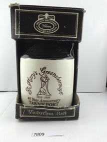
Container - Bottle, St Mary's Greensborough 40 year anniversary tawny port, 1995
... Greensborough Historical Society 34A Glenauburn Road Lower Plenty Lower Plenty melbourne Commemorative Port issued in 1995 to celebrate the 40th anniversary of the opening of St Mary's Church in Greensborough. st marys parish greensborough st marys catholic church greensborough brown brothers Brown Brothers Milawa Vineyard Australia: Viictorian Port on cardboard container Ceramic wine bottle with cork in cardboard container, black and white St Mary's Greensborough 40 year anniversary tawny port Container Bottle ...Commemorative Port issued in 1995 to celebrate the 40th anniversary of the opening of St Mary's Church in Greensborough.Ceramic wine bottle with cork in cardboard container, black and whiteBrown Brothers Milawa Vineyard Australia: Viictorian Port on cardboard containerst marys parish greensborough, st marys catholic church greensborough, brown brothers -
 Greensborough Historical Society
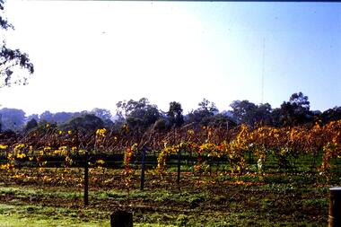
Slide - Photograph, John Ramsdale, Vineyard: Slide 21, 1990s
... Greensborough Historical Society 34A Glenauburn Road Lower Plenty Lower Plenty melbourne Photograph shows grape vines in autumn. This vineyard is located near Rosanna Golf Course. ...Photograph shows grape vines in autumn. This vineyard is located near Rosanna Golf Course.Part of the John Ramsdale collection of slides and audio visual material.Colour photograph scanned from slide.No maker's marks. No caption on slide.vineyards, rosanna golf course -
 Greensborough Historical Society
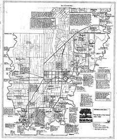
Map, Heidelberg. Historic River Landscape Assessment. Historical maps: Map C 1851-1863. "The Garden of the colony", 1985c
... Geographical area of around 35 sq. kilometres marked with physical features such as major roads, vegetation and properties, with locations and notes of the increasing number of farms, gardens orchards and vineyards which had become established in addition to pastoral runs. ...Greensborough Historical Society 34A Glenauburn Road Lower Plenty Lower Plenty melbourne Geographical area of around 35 sq. kilometres marked with physical features such as major roads, vegetation and properties, with locations and notes of the increasing number of farms, gardens orchards and vineyards which had become established in addition to pastoral runs. ...Geographical area of around 35 sq. kilometres marked with physical features such as major roads, vegetation and properties, with locations and notes of the increasing number of farms, gardens orchards and vineyards which had become established in addition to pastoral runs. Bounded by Shire of Diamond Valley to the North, Darebin Creek to the West and Plenty River to the East.Black and white sketch map on white paperheidelberg, heidelberg - maps -
 Greensborough Historical Society
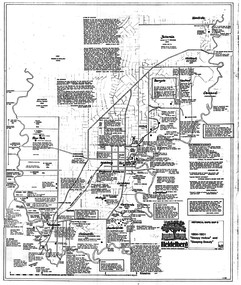
Map, Heidelberg: Historic River Landscape Assessment. Historical maps. Map D 1864 -1901 "Sleepy Hollow" and "Sleeping beauty", 1985c
... Geographical area of c. 35 sq. kilometres marked with physical features such as major roads, rivers, vegetation and properties, with locations and notes on the increasing number of farms, orchards and vineyards that had been developed in addition to pastoral runs. ...Greensborough Historical Society 34A Glenauburn Road Lower Plenty Lower Plenty melbourne Geographical area of c. 35 sq. kilometres marked with physical features such as major roads, rivers, vegetation and properties, with locations and notes on the increasing number of farms, orchards and vineyards that had been developed in addition to pastoral runs. ...Geographical area of c. 35 sq. kilometres marked with physical features such as major roads, rivers, vegetation and properties, with locations and notes on the increasing number of farms, orchards and vineyards that had been developed in addition to pastoral runs. Bounded by Shire of Diamond Valley to the North, Darebin Creek to the West, and Plenty River to the East.Black and white sketch on white paper. Second copy 600 x 430 cm printed in black on semi-opaque paperheidelberg, heidelberg - maps -
 Montmorency–Eltham RSL Sub Branch
Souvenir - 38th Anniversary Bottle of Port commemorating the Battle of Kapyong, Korea, 1951, 1989
... Montmorency–Eltham RSL Sub Branch Petrie Park 16 Mountain View Road Montmorency melbourne Kapyong 1989 is at top of label with emblem between, then 111, 38th year, Kapyong, Commemorative Port. 750 ml. Wine made in Australia. 18% Alc/vol. Mt Aitken Vineyard ...Black bottle with long neck, made of black glass with black metal screw top and label front and backKapyong 1989 is at top of label with emblem between, then 111, 38th year, Kapyong, Commemorative Port. 750 ml. Wine made in Australia. 18% Alc/vol. Mt Aitken Vineyard Gisborne Vic On the back of the bottle -
 Bendigo Historical Society Inc.
Newsletter - The Grapevine Cuttings by Rob Upson, 1998 to 2000
... 10828.32 The Weekly Times 1869 10828.33 Mark Twain in Australia 10828.34 Bendigo’s Jewish Synagogue 10828.35 Sly Grog on the Goldfields 10828.36 A Brief History of Breweries in Australia 10828.37 The Breweries of Bendigo 10828.38 The Cohn Brothers of Bendigo 10828.39 Mary McCarthy – aged 114 10828.40 Langley Hall and Bishopscourt 10828.41 William ‘Bendigo’ Thompson 10828.42 Lachlan MacLachlan 10828.43 ‘Said Hanrahan’ by John O’Brien 10828.44 The Origin of Sandhurst 10828.45 Lister House 10828.46 Arthur Thomas Woodward 10828.47 The Students of Arthur Thomas Woodward 10828.48 Henry Leggo 10828.49 Chiko Rolls and Four ‘n Twenty Pies 10828.50 HMVS Nelson and Victoria’s Navy (Parts 1 and 2) 10828.52 Anthony Trollope in Australia (Part 1 to 3) 10828.55 Regional Towns of Victoria – a Quiz 10828.56 Exploration and Settlement of Victoria (Parts 1 and 2) 10828.58 The Major Mitchell Expedition into Victoria (Parts 1 to 3) 10828.61 The Gold Rush (Part 1 and 2) 10828.63 The Road to the Diggings (Part 1 and 2) 10828.65 Harold Desbrowe-Annear (Part 1 and 2) 10828.71 Nom de Plumes 10828.72 The New Zealand Gold Rush 10828.73 Ernst Mueller and Ettore Cadorin 10828.74 Sir John Monash 10828.75 P & O Ships 10828.76 Rosalind Park 10828.82 Bendigo Street Names 10828.83 A Constitutional Proposal and Early Bendigo Vineyards 10828.84 Ferdinand von Mueller 10828.85 John Boyd Watson...10828.32 The Weekly Times 1869 10828.33 Mark Twain in Australia 10828.34 Bendigo’s Jewish Synagogue 10828.35 Sly Grog on the Goldfields 10828.36 A Brief History of Breweries in Australia 10828.37 The Breweries of Bendigo 10828.38 The Cohn Brothers of Bendigo 10828.39 Mary McCarthy – aged 114 10828.40 Langley Hall and Bishopscourt 10828.41 William ‘Bendigo’ Thompson 10828.42 Lachlan MacLachlan 10828.43 ‘Said Hanrahan’ by John O’Brien 10828.44 The Origin of Sandhurst 10828.45 Lister House 10828.46 Arthur Thomas Woodward 10828.47 The Students of Arthur Thomas Woodward 10828.48 Henry Leggo 10828.49 Chiko Rolls and Four ‘n Twenty Pies 10828.50 HMVS Nelson and Victoria’s Navy (Parts 1 and 2) 10828.52 Anthony Trollope in Australia (Part 1 to 3) 10828.55 Regional Towns of Victoria – a Quiz 10828.56 Exploration and Settlement of Victoria (Parts 1 and 2) 10828.58 The Major Mitchell Expedition into Victoria (Parts 1 to 3) 10828.61 The Gold Rush (Part 1 and 2) 10828.63 The Road to the Diggings (Part 1 and 2) 10828.65 Harold Desbrowe-Annear (Part 1 and 2) 10828.71 Nom de Plumes 10828.72 The New Zealand Gold Rush 10828.73 Ernst Mueller and Ettore Cadorin 10828.74 Sir John Monash 10828.75 P & O Ships 10828.76 Rosalind Park 10828.82 Bendigo Street Names 10828.83 A Constitutional Proposal and Early Bendigo Vineyards 10828.84 Ferdinand von Mueller 10828.85 John Boyd Watson Newsletter The Grapevine Cuttings by Rob Upson ...Rob Upson became a volunteer at the Bendigo Visitor Centre in 1998. The Staff produced a monthly newsletter called ‘The Grapevine’. Being reasonably new to Bendigo, Rob became interested in its history and began writing articles to share with the volunteers. He called them ‘Grapevine Cuttings’ under the pen name of ‘Merlot’. Rob wrote about 90 articles over a period of 12 years until ‘The Grapevine’ was finally pruned and shutdown. Rob is a valuable volunteer for the Bendigo Historical Society.Sixty Five Newsletters in PDF format from the Grapevine collection that cover the following historical items: Grapevine Newsletters by Rob Upson (Bendigo Historical Society) 10828 Index 10828 Index - Parent Document (This Page) 10828.00 ‘Objection your Honour’ 10828.01 Bendigo’s Gold Volume 10828.02 Harry Boyle (Cricketer) 10828.03 Ellen Clacy on the Goldfields 10828.04 Gold Fever and Vandemonians 10828.05 The Railway to Bendigo (Part 1 and 2) 10828.07 The Pioneer’s Grave at Maiden Gully 10828.08 The First Parliamentary Election, Bendigo 1855 10828.09 The Origin of Place Names 10828.10 The Tram (Parts 1 to 4) 10828.13 W.D.C. Denovan 10828.14 Knipe’s Castle 10828.15 John Hanlon Knipe 10828.16 1st January 1900 in Bendigo 10828.17 William Gay – Bendigo Poet 10828.18 St. Aidan’s Orphanage 10828.19 The Year 2000 – a Prediction from 1967 10828.20 Dr. Henry Backhaus 10828.21 St. Kilian’s Catholic Church 10828.22 S.T. Gill – Goldfields Artist 10828.23 Cobb and Co. 10828.24 ‘The Lights of Cobb and Co.’ by Henry Lawson 10828.25 Federation Celebrations – Sydney 1901 10828.26 The Australian Flag of Stars 10828.27 Old Treasury Building – Melbourne 10828.28 Key Dates in Bendigo’s First 50 Years 10828.29 The March from Robe to Bendigo and China’s Long March 10828.30 A Goldfields Quiz 10828.31 Did You Know That ………..? 10828.32 The Weekly Times 1869 10828.33 Mark Twain in Australia 10828.34 Bendigo’s Jewish Synagogue 10828.35 Sly Grog on the Goldfields 10828.36 A Brief History of Breweries in Australia 10828.37 The Breweries of Bendigo 10828.38 The Cohn Brothers of Bendigo 10828.39 Mary McCarthy – aged 114 10828.40 Langley Hall and Bishopscourt 10828.41 William ‘Bendigo’ Thompson 10828.42 Lachlan MacLachlan 10828.43 ‘Said Hanrahan’ by John O’Brien 10828.44 The Origin of Sandhurst 10828.45 Lister House 10828.46 Arthur Thomas Woodward 10828.47 The Students of Arthur Thomas Woodward 10828.48 Henry Leggo 10828.49 Chiko Rolls and Four ‘n Twenty Pies 10828.50 HMVS Nelson and Victoria’s Navy (Parts 1 and 2) 10828.52 Anthony Trollope in Australia (Part 1 to 3) 10828.55 Regional Towns of Victoria – a Quiz 10828.56 Exploration and Settlement of Victoria (Parts 1 and 2) 10828.58 The Major Mitchell Expedition into Victoria (Parts 1 to 3) 10828.61 The Gold Rush (Part 1 and 2) 10828.63 The Road to the Diggings (Part 1 and 2) 10828.65 Harold Desbrowe-Annear (Part 1 and 2) 10828.71 Nom de Plumes 10828.72 The New Zealand Gold Rush 10828.73 Ernst Mueller and Ettore Cadorin 10828.74 Sir John Monash 10828.75 P & O Ships 10828.76 Rosalind Park 10828.82 Bendigo Street Names 10828.83 A Constitutional Proposal and Early Bendigo Vineyards 10828.84 Ferdinand von Mueller 10828.85 John Boyd Watsonhistory, bendigo, grapevine cuttings -
 Bendigo Historical Society Inc.
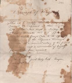
Administrative record - Borough of Raywood Frederick Code employment contract, November 13th, 1888
... Road, Longlea, in the mid 1970s. It has been stored in my photo album ever since. Code's had a property along Axe Creek/McIvor Highway and there is a Code's Lane there now. Anecdotal, and possibly quite untrue, they had a vineyard...Road, Longlea, in the mid 1970s. It has been stored in my photo album ever since. Code's had a property along Axe Creek/McIvor Highway and there is a Code's Lane there now. Anecdotal, and possibly quite untrue, they had a vineyard ..."This item was found in a suitcase of rubbish along Axe Creek Road, Longlea, in the mid 1970s. It has been stored in my photo album ever since. Code's had a property along Axe Creek/McIvor Highway and there is a Code's Lane there now. Anecdotal, and possibly quite untrue, they had a vineyard and were wiped out by phylloxera." ( Rodney Edwards, donor, 26th August 2024) One page document, parchment colour. Written across of document 'Borough of Raywood". Letter signed by Jacob Philip Balk Mayor, November 13th. 1888, outlining the employment details for Frederick George Code as 'the Officer of Herdsman of the Raywood Borough and Common at a nominal salary of one pound per annum and a commission of eighty per cent on fees received'. Handwritten on back of document: 'Bendigo Jam Factory 1902, January 11th. (indecipherable) lot Plums ten cases 2 ct 2 gr @ 40/-, 5.'frederick code, raywood pound, raywood common, axe creek, axedale, axedale pound -
 Bendigo Historical Society Inc.
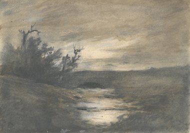
Drawing - HARRIS COLLECTION: CHARCOAL SKETCH AXE CREEK, AXEDALE
... Most probably sketch of Harris property, orchard and vineyard on Axe Creek, Mt. Sugarloaf Road, Axedale....Most probably sketch of Harris property, orchard and vineyard on Axe Creek, Mt. Sugarloaf Road, Axedale. Drawing HARRIS COLLECTION: CHARCOAL SKETCH AXE CREEK, AXEDALE ...Charcoal sketch on cream background of water course, trees on left hand side. Most probably sketch of Harris property, orchard and vineyard on Axe Creek, Mt. Sugarloaf Road, Axedale.George Harris, Axedaleartwork, axedale, george harris -
 Bendigo Historical Society Inc.
Drawing - HARRIS COLLECTION: CHARCOAL SKETCH OF CREEK AND HUT
... Most probably a depiction of the Harris orchard/vineyard on Axe Creek, Axedale, near the bridge on the Mt. Sugarloaf Road....Most probably a depiction of the Harris orchard/vineyard on Axe Creek, Axedale, near the bridge on the Mt. Sugarloaf Road. Drawing HARRIS COLLECTION: CHARCOAL SKETCH OF CREEK AND HUT ...Charcoal sketch on cream background of creek, small hut on bank, eucalypts on LH side and in background. Most probably a depiction of the Harris orchard/vineyard on Axe Creek, Axedale, near the bridge on the Mt. Sugarloaf Road.George Harris, Axedaleartwork, harris vineyard -
 Bendigo Historical Society Inc.
Photograph - STRAUCH COLLECTION: ADVENTURE VINEYARD
... Copy of photograph of the Adventure Vineyard Tannery Lane Mandurang. Photo courtesy Mrs Frieda Legg 1/12 Chathem Road Canterbury Vic 3126....Frieda Legg is the daughter of Frieda and Stephen Chambers PHOTOGRAPH House vineyard Bendigo-history-vineyards-mandurang Copy of photograph of the Adventure Vineyard Tannery Lane Mandurang. Photo courtesy Mrs Frieda Legg 1/12 Chathem Road Canterbury Vic 3126. ...See Item 10641.63 for Barth family. Frieda Legg is the daughter of Frieda and Stephen ChambersCopy of photograph of the Adventure Vineyard Tannery Lane Mandurang. Photo courtesy Mrs Frieda Legg 1/12 Chathem Road Canterbury Vic 3126.photograph, house, vineyard, bendigo-history-vineyards-mandurang -
 Bendigo Historical Society Inc.
Document - SEDGWICK INFORMATION
... Road District was Proclaimed. Five years later it became the Shire of Strayhfieldsaye.Mining west of the Axe Creek commenced in 1863. Agriculture, farmers made modest livings from vineyards, orchards,dairy cattle, eggs and tomatoes. ...Road District was Proclaimed. Five years later it became the Shire of Strayhfieldsaye.Mining west of the Axe Creek commenced in 1863. Agriculture, farmers made modest livings from vineyards, orchards,dairy cattle, eggs and tomatoes. ...Document, Sedgwick, was known as Upper Emu Creek until 1901. It is located ten miles south of Bendigo in hilly sedimentary and granite country.The first freehold grants were taken up in 1854. In 1861 the Strathfieldsaye Road District was Proclaimed. Five years later it became the Shire of Strayhfieldsaye.Mining west of the Axe Creek commenced in 1863. Agriculture, farmers made modest livings from vineyards, orchards,dairy cattle, eggs and tomatoes. The Osborne family had seventy acres planted to apples. Prior to 1934 Favaloros collected cream from district farms, then fresh milk in cans was carted to Bendigo until 1970.document, sedgwick -
 Bendigo Historical Society Inc.
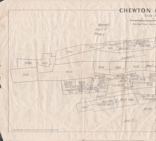
Map - MINING REPORTS - PLAN OF CHEWTON GOLDFIELD 1937
... Plan shows the township of Chewton with the reefs and leases, the railway line and the Main Castlemaine - Melbourne Road. Also, the Eureka Vineyard. Issued by The Stock Exchange of Melbourne, April 1937. ...Plan shows the township of Chewton with the reefs and leases, the railway line and the Main Castlemaine - Melbourne Road. Also, the Eureka Vineyard. Issued by The Stock Exchange of Melbourne, April 1937. ...Plan of the Chewton Goldfield with Scale Measurement in chains. Plan shows the township of Chewton with the reefs and leases, the railway line and the Main Castlemaine - Melbourne Road. Also, the Eureka Vineyard. Issued by The Stock Exchange of Melbourne, April 1937. Leases named are: Central Wattle Gully, Wattle Gully United, Wattle Gully Extended, South Wattle Gully, Golden Wattle, Chewton, White Horse, Wattle Gully, North Wattle Gully, North Chewton, Upper Barkly, Post Office Hill, Misima United, Argus Hill, Chapmans, Chewton Prospecting Co, Fiji Gold & Gold Mines of Fiji and Nimrod. Stamp in the top right corner: Edward Dyason & Co. - Queen St. Melbourne. Sharebrokers.map, mining reports, plan of chewton goldfield, edward dyason & co, the stock exchange of melbourne, central wattle gully, wattle gully united, wattle gully extended, south wattle gully, golden wattle, chewton, white horse, wattle gully, north wattle gully, north chewton, upper barkly, post office hill, misima united, argus hill, chapmans, chewton prospecting co, fiji gold & gold mines of fiji, nimrod -
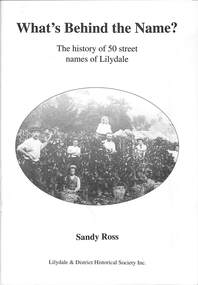 Ringwood and District Historical Society
Book, Sandy Ross, What's Behind the Name?, 2005
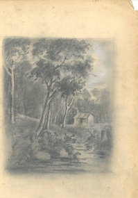
... Ringwood and District Historical Society 125A Warrandyte Road Ringwood North melbourne Front page: Pickers at The Towers Vineyard with the earthworks for the new railway line to Warburton in the background. c1900. ...The history of 50 street names of Lilydale by Sandy Ross, Lilydale & District Historical Society Inc.Front page: Pickers at The Towers Vineyard with the earthworks for the new railway line to Warburton in the background. c1900.