Showing 51 items matching "volcanic hills"
-
 Victorian Interpretive Projects Inc.
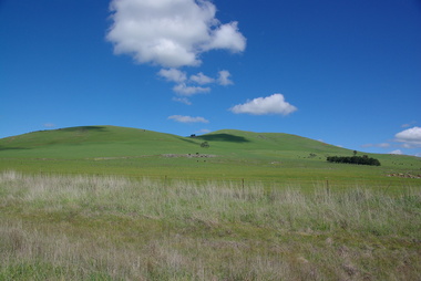
Photograph - Colour, Clare Kathleen Gervasoni, Smeaton Volcanic Landscapes, 2013, 22/09/2013
... Five landscape photographs of the seven volcanic hills around Smeaton....PO Box 93R, Redan, 3350 goldfields Smeaton Hill was the name of the property first settled by squatter Captain John Hepburn and Elizabeth Hepburn. Smeaton Kooroocheang John Hepburn John Hepburn Elizabeth Hepburn volcano volcanic Five landscape photographs of the seven volcanic hills around Smeaton. ...Smeaton Hill was the name of the property first settled by squatter Captain John Hepburn and Elizabeth Hepburn.Five landscape photographs of the seven volcanic hills around Smeaton.smeaton, kooroocheang, john hepburn, john hepburn, elizabeth hepburn, volcano, volcanic -
 Victorian Interpretive Projects Inc.
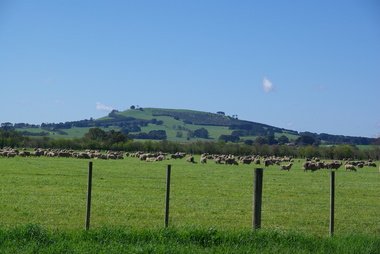
Photograph - Colour, Clare Kathleen Gervasoni, Smeaton from Queen Street, 2013, 22/09/2013
... A volcanic hill as seen from Queen Street, Smeaton, Victoria...PO Box 93R, Redan, 3350 goldfields Smeaton volcano volcanic A volcanic hill as seen from Queen Street, Smeaton, Victoria Smeaton from Queen Street, 2013 Photograph - Colour Clare Kathleen Gervasoni ...A volcanic hill as seen from Queen Street, Smeaton, Victoriasmeaton, volcano, volcanic -
 Victorian Interpretive Projects Inc.
Photograph - Photograph - Colour, Clare Gervasoni, Valcanic Hills From Near Newlyn, 2019, 19/10/2020
... ...volcanic hills...PO Box 93R, Redan, 3350 goldfields Newlyn agriculture horticulture volcanic hills mammalian hills Canola in bloom near Newlyn Valcanic Hills From Near Newlyn, 2019 Photograph Photograph - Colour Clare Gervasoni ...Canola in bloom near Newlynnewlyn, agriculture, horticulture, volcanic hills, mammalian hills -
 Ballarat Heritage Services
Photograph - Colour, Volcanic Crater at Tower Hill, 2017, 2017
... Volcanic Crater at Tower Hill, 2017...Tower Hill is a volcanic formation believed to have erupted about 32,000 years ago. ...Colour photographs of a lake in a volcanic crater at Tower Hill, Victoria. ...(https://www.towerhill.org.au/index.php/about-reserve/history, accessed 23 December 2019) volcano crater lake tower hill Colour photographs of a lake in a volcanic crater at Tower Hill, Victoria. ...Tower Hill is a volcanic formation believed to have erupted about 32,000 years ago. Its formation is known as a "nested maar" and it is the largest example of its type in Victoria. During formation, molten lava pushed its way up through the Earth’s crust and encountered a layer of water-bearing rock. Violent explosions followed creating a shallow crater which later filled with water to form the lake. Further eruptions occurred in the centre of this crater, creating the islands and cone shaped hills. In 1892 Tower Hill became Victoria’s first National Park. In 1961, Tower Hill became a State Game Reserve under the then Fisheries and Wildlife Department and a major re-vegetation program began. (https://www.towerhill.org.au/index.php/about-reserve/history, accessed 23 December 2019)Colour photographs of a lake in a volcanic crater at Tower Hill, Victoria. volcano, crater, lake, tower hill -
 Bendigo Historical Society Inc.
Book - BAILLIERE'S VICTORIAN GAZETTEER AND ROAD GUIDE, 1870
... Includes small hamlets postal villages and volcanic hills. Newspaper clipping refering to Marysville. ...Includes small hamlets postal villages and volcanic hills. Newspaper clipping refering to Marysville. ...Bailliere's Victorian Gazetteer and Road Guide. The most recent and accurate information as th every place in the colony. Second edition, with additions to date. Includes small hamlets postal villages and volcanic hills. Newspaper clipping refering to Marysville. Newspaper clipping referring to Harkaway. Clipping of sale of YMCA, sale of freehold at corner of High and Short Sts. Invitations from Bendigo and Northern District Hospital to H. Curnow. This item also has numerous references to other things that apply to the invitation. Old Post Office telegram form with notes on the back. Mixed amid inner pages is yellow card with typwritten description of the book's name. At front and back there are numerous pages of advertisements.Robt. P. Whitworthvictoria, history, people and places in victoria. -
 Eltham District Historical Society Inc
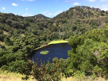
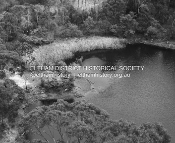
Photograph - Digital Photograph, Alan King, Blue Lake, Plenty Gorge Park, 2008
... On the Nillumbik side are undulating hills and sedimentary rock, and in Whittlesea, lies a basalt plain formed by volcanic action up to two million years ago. ...On the Nillumbik side are undulating hills and sedimentary rock, and in Whittlesea, lies a basalt plain formed by volcanic action up to two million years ago. ...A quarry was transformed into the Blue Lake. Published: Nillumbik Now and Then / Marguerite Marshall 2008; photographs Alan King with Marguerite Marshall.; p179 The dramatic steep-sided Plenty Gorge lies along the divide of two geological areas, and separates the Nillumbik Shire and the City of Whittlesea. On the Nillumbik side are undulating hills and sedimentary rock, and in Whittlesea, lies a basalt plain formed by volcanic action up to two million years ago. This provides the Plenty Gorge Park with diverse vegetation and habitats, making it one of Greater Melbourne’s most important refuges for threatened and significant species. The park, established in 1986, consists of around 1350 hectares, and extends 11 kilometres along the Plenty River, from Greensborough to Mernda. It provides a wildlife corridor for around 500 native plant and 280 animal species. The area’s plentiful food and water attracted the Wurundjeri Aboriginal people and then European settlers. By 1837 squatters had claimed large runs of land for their sheep and cattle. The Plenty Valley was among the first in the Port Phillip District to be settled - mainly in the less heavily timbered west - and was proclaimed a settled district in 1841.But by the late 1880s, the settlers’ extensive land clearing for animal grazing, then agriculture, depleted the Wurundjeri’s traditional food sources, which helped to drive them away. Many Wurundjeri artefacts remain (now government protected), and so far 57 sites have been identified in the park, including scarred trees, burial areas and stone artefacts. Pioneer life could be very hard because of isolation, flooding, bushfires and bushrangers. Following the Black Thursday bushfires of 1851, basalt was quarried to build more fire-resistant homes. Gold discoveries in the early 1850s swelled the population, particularly around Smugglers Gully; but food production made more of an impact. In the late 1850s wheat production supplanted grazing. In the 1860s the government made small holdings available to poorer settlers. These had the greatest effect on the district, particularly in Doreen and Yarrambat, where orchards were established from the 1880s to 1914. Links with a prominent early family are the remains of Stuchbery Farm, by the river’s edge bounded by Smugglers Gully to the north and La Trobe Road, Yarrambat, to the east. The Stuchberys moved to the valley in 1890, and the family still lives in the area. In 1890, Alfred and Ada first lived in a tent where four children were born, then Alfred built the house and outbuildings around 1896. They planted an orchard, then a market garden, and developed a dairy. The family belonged to the local Methodist and tennis communities. Their grandson Walter, opened the Flying Scotsman Model Railway Museum in Yarrambat, which his widow, Vi, continues to run. Wal was also the Yarrambat CFA Captain for 22 years until 1987. Walter sold 24 hectares in 1976 for development - now Vista Court - and in 1990, the remaining 22.6 hectares for the park. Remaining are an early stone dairy and remnants of a stone barn, a pig sty and a well. Until it was destroyed by fire in 2003, a slab hut stood on the Happy Hollow Farm site, at the southern end of the park. The hut is thought to have been built in the Depression around 1893. This was a rare and late example of a slab hut with a domestic orchard close to Melbourne. Emmet Watmough and his family first occupied the hut, followed by a succession of families, until the Bell family bought it around 1948. There they led a subsistence lifestyle for 50 years, despite encroaching Melbourne suburbia. The Yellow Gum Recreation Area includes the Blue Lake, coloured turquoise at certain times of the year. Following the 1957 bushfires, this area was quarried by Reid Quarries Pty Ltd for Melbourne’s first skyscrapers, then by Boral Australia. However in the early 1970s water began seeping into the quarry forming the Blue Lake and the quarry was closed. The State Government bought the site in 1997 and opened it as a park in 1999.This collection of almost 130 photos about places and people within the Shire of Nillumbik, an urban and rural municipality in Melbourne's north, contributes to an understanding of the history of the Shire. Published in 2008 immediately prior to the Black Saturday bushfires of February 7, 2009, it documents sites that were impacted, and in some cases destroyed by the fires. It includes photographs taken especially for the publication, creating a unique time capsule representing the Shire in the early 21st century. It remains the most recent comprehenesive publication devoted to the Shire's history connecting local residents to the past. nillumbik now and then (marshall-king) collection, blue lake, plenty gorge park -
 Eltham District Historical Society Inc
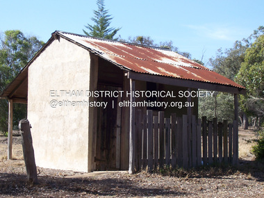
Photograph - Digital Photograph, Marguerite Marshall, Stuchbery Farm dairy, 14 March 2008
... On the Nillumbik side are undulating hills and sedimentary rock, and in Whittlesea, lies a basalt plain formed by volcanic action up to two million years ago. ...On the Nillumbik side are undulating hills and sedimentary rock, and in Whittlesea, lies a basalt plain formed by volcanic action up to two million years ago. ...Stuchbery Farm was situated on the Plenty River bounded by Smugglers Gully to the north and La trobe Road, Yarrambat, to the east. Alan and Ada Stutchbery moved to the valley in 1890, first living in a tent where four children were born. Alfred built a home and outbuildings around 1896. They planted an orchard, then a market garden and developed a dairy. Published: Nillumbik Now and Then / Marguerite Marshall 2008; photographs Alan King with Marguerite Marshall.; p179 The dramatic steep-sided Plenty Gorge lies along the divide of two geological areas, and separates the Nillumbik Shire and the City of Whittlesea. On the Nillumbik side are undulating hills and sedimentary rock, and in Whittlesea, lies a basalt plain formed by volcanic action up to two million years ago. This provides the Plenty Gorge Park with diverse vegetation and habitats, making it one of Greater Melbourne’s most important refuges for threatened and significant species. The park, established in 1986, consists of around 1350 hectares, and extends 11 kilometres along the Plenty River, from Greensborough to Mernda. It provides a wildlife corridor for around 500 native plant and 280 animal species. The area’s plentiful food and water attracted the Wurundjeri Aboriginal people and then European settlers. By 1837 squatters had claimed large runs of land for their sheep and cattle. The Plenty Valley was among the first in the Port Phillip District to be settled - mainly in the less heavily timbered west - and was proclaimed a settled district in 1841. But by the late 1880s, the settlers’ extensive land clearing for animal grazing, then agriculture, depleted the Wurundjeri’s traditional food sources, which helped to drive them away. Many Wurundjeri artefacts remain (now government protected), and so far 57 sites have been identified in the park, including scarred trees, burial areas and stone artefacts. Pioneer life could be very hard because of isolation, flooding, bushfires and bushrangers. Following the Black Thursday bushfires of 1851, basalt was quarried to build more fire-resistant homes. Gold discoveries in the early 1850s swelled the population, particularly around Smugglers Gully; but food production made more of an impact. In the late 1850s wheat production supplanted grazing. In the 1860s the government made small holdings available to poorer settlers. These had the greatest effect on the district, particularly in Doreen and Yarrambat, where orchards were established from the 1880s to 1914. Links with a prominent early family are the remains of Stuchbery Farm, by the river’s edge bounded by Smugglers Gully to the north and La Trobe Road, Yarrambat, to the east. The Stuchberys moved to the valley in 1890, and the family still lives in the area. In 1890, Alfred and Ada first lived in a tent where four children were born, then Alfred built the house and outbuildings around 1896. They planted an orchard, then a market garden, and developed a dairy. The family belonged to the local Methodist and tennis communities. Their grandson Walter, opened the Flying Scotsman Model Railway Museum in Yarrambat, which his widow, Vi, continues to run. Wal was also the Yarrambat CFA Captain for 22 years until 1987. Walter sold 24 hectares in 1976 for development - now Vista Court - and in 1990, the remaining 22.6 hectares for the park. Remaining are an early stone dairy and remnants of a stone barn, a pig sty and a well. Until it was destroyed by fire in 2003, a slab hut stood on the Happy Hollow Farm site, at the southern end of the park. The hut is thought to have been built in the Depression around 1893. This was a rare and late example of a slab hut with a domestic orchard close to Melbourne. Emmet Watmough and his family first occupied the hut, followed by a succession of families, until the Bell family bought it around 1948. There they led a subsistence lifestyle for 50 years, despite encroaching Melbourne suburbia. The Yellow Gum Recreation Area includes the Blue Lake, coloured turquoise at certain times of the year. Following the 1957 bushfires, this area was quarried by Reid Quarries Pty Ltd for Melbourne’s first skyscrapers, then by Boral Australia. However in the early 1970s water began seeping into the quarry forming the Blue Lake and the quarry was closed. The State Government bought the site in 1997 and opened it as a park in 1999.This collection of almost 130 photos about places and people within the Shire of Nillumbik, an urban and rural municipality in Melbourne's north, contributes to an understanding of the history of the Shire. Published in 2008 immediately prior to the Black Saturday bushfires of February 7, 2009, it documents sites that were impacted, and in some cases destroyed by the fires. It includes photographs taken especially for the publication, creating a unique time capsule representing the Shire in the early 21st century. It remains the most recent comprehenesive publication devoted to the Shire's history connecting local residents to the past. nillumbik now and then (marshall-king) collection, ada stuchbery, alan stuchbery, dairy, stuchbery farm, farm buildings, yarrambat, plenty gorge park -
 Eltham District Historical Society Inc
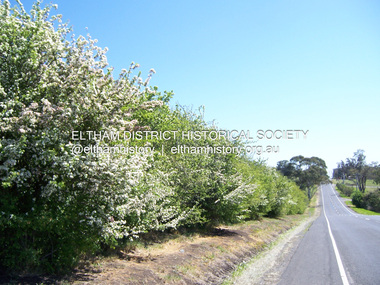
Photograph - Digital Photograph, Marguerite Marshall, Hawthorn hedges, Eltham-Yarra Glen Road, Kangaroo Ground, 3 October 2006
... volcanic soil could sustain an amazing two crops a year. By the mid 1850s, 500 acres (202ha) of wheat were growing in Kangaroo Ground. But the crops were threatened by kangaroos, which were so plentiful, that Surveyor-General, Robert Hoddle, named the district Kangaroo Ground in 1838. As post-and-rail fences proved inadequate barriers for the bounding kangaroos, the Scots planted hawthorn hedgerows as they had done in Scotland. Some also used the hedges to net birds, presumably for the table. Interestingly the farmers in the bordering townships of Panton Hill...volcanic soil could sustain an amazing two crops a year. By the mid 1850s, 500 acres (202ha) of wheat were growing in Kangaroo Ground. But the crops were threatened by kangaroos, which were so plentiful, that Surveyor-General, Robert Hoddle, named the district Kangaroo Ground in 1838. As post-and-rail fences proved inadequate barriers for the bounding kangaroos, the Scots planted hawthorn hedgerows as they had done in Scotland. Some also used the hedges to net birds, presumably for the table. Interestingly the farmers in the bordering townships of Panton Hill ...Hawthorn hedges are important reminders of Kangaroo Ground's Scottish heritage. They are Registered on the Victorian Heritage Register. They are "historically significant because the planting of hawthorn hedges reflects the adoption of Eurorpean farming techniques by the Kangaroo Ground population in the period following settlement and because the grid pattern of paddocks that the Hawthorn hedges define is very different to today's farm landscapes." Covered under Heritage Overlay, Nillumbik Planning Scheme. Published: Nillumbik Now and Then / Marguerite Marshall 2008; photographs Alan King with Marguerite Marshall.; p21 Hawthorn hedges bordering Kangaroo Ground’s gently rolling farmlands are important reminders of its Scottish heritage and are rare so close to Melbourne.1 As early as the 1840s newly arrived farmers from Scotland planted hawthorn hedges around their properties, to protect crops from the numerous kangaroos and wallabies. Many of these hedges survive today. These farmers had the good fortune to settle some of the most fertile land available for cropping in the Colony of Victoria. At that time the black volcanic soil could sustain an amazing two crops a year. By the mid 1850s, 500 acres (202ha) of wheat were growing in Kangaroo Ground. But the crops were threatened by kangaroos, which were so plentiful, that Surveyor-General, Robert Hoddle, named the district Kangaroo Ground in 1838. As post-and-rail fences proved inadequate barriers for the bounding kangaroos, the Scots planted hawthorn hedgerows as they had done in Scotland. Some also used the hedges to net birds, presumably for the table. Interestingly the farmers in the bordering townships of Panton Hill and Christmas Hills, did not plant hawthorn hedges around their properties. Perhaps it was because by the time they settled in the 1860s and 1870s most of the wildlife had been gunned down by residents.2 The canny Scots planted the hedges on public land outside their own farms, as the hedgerows could spread to about five yards (five m) in width. With this impenetrable barrier Kangaroo Ground’s industrious farmers flourished to gain the economic power that saw the Shire of Eltham governed from Kangaroo Ground for 79 years (1858-1937). The Scots jealously guarded their land, so hard to get in Scotland. That is why they refused to release any of it ‘for local roads to follow easier grades as was the case in surrounding districts where roads generally followed ridgelines or streams’.3 Instead the roads were built in accordance with the magnetic bearings of their first survey in 1847 whether that suited the steep topography or not. This could force traffic to diverge when wet through Greensborough and Diamond Creek. Until 1921, the Eltham-Yarra Glen Road beside Wellers Restaurant, ‘dipped down into the upper reaches of Stony Creek’.4 Later some corners were compulsorily cut for the increasing motor traffic. As late as the 1960s, corners were cut to form sweeping curves above and alongside the Kangaroo Ground Cemetery and opposite the Emergency Operations Centre. In the latter case, the farmers – understanding their hedgerows as important heritage – insisted upon their reinstatement to conform to the altered road alignment. Kangaroo Ground’s ancient manna gums also point to the district’s history and to that of the hedgerows. The Aboriginal people had transformed the original forests into grasslands with the fires they lit to attract kangaroos, (which the Scots were to exclude by planting hedgerows). But the Wurundjeri hunters left the gums (Eucalyptus vimminalis cygnetensis), on the grasslands as ‘stalking trees’ to hunt kangaroos. The hawthorn hedges in Kangaroo Ground were neglected for around 60 years from about the middle of the 20th century. Bushfires had created gaps and the hedgerows were not trimmed. Then in late 2005, local historian Mick Woiwod, formed a group to lobby the Nillumbik Shire to restore the hedges, which could last for many centuries. Some hedges in parts of Britain date back to AD 800.5 Although the original Scottish farmers have gone, the hedges are a reminder of when they flourished in the district, which has changed little in 150 years.This collection of almost 130 photos about places and people within the Shire of Nillumbik, an urban and rural municipality in Melbourne's north, contributes to an understanding of the history of the Shire. Published in 2008 immediately prior to the Black Saturday bushfires of February 7, 2009, it documents sites that were impacted, and in some cases destroyed by the fires. It includes photographs taken especially for the publication, creating a unique time capsule representing the Shire in the early 21st century. It remains the most recent comprehenesive publication devoted to the Shire's history connecting local residents to the past. nillumbik now and then (marshall-king) collection, eltham-yarra glen road, hawthorn hedgerow, kangaroo ground -
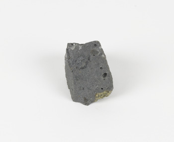 The Beechworth Burke Museum
Geological specimen - Basalt (igneous-volcanic) containing Olivine, unknown
... The mountain is an example of a breached scoria cone (a steep conical hill of loose pyroclastic fragments) which was created by a volcanic eruption about 470,000 years ago, a date which may indicate the age of this geological specimen. ...The mountain is an example of a breached scoria cone (a steep conical hill of loose pyroclastic fragments) which was created by a volcanic eruption about 470,000 years ago, a date which may indicate the age of this geological specimen. ...This particular geological specimen was found in Mount Franklin or Lalgambook in Djadjawurrung, located between Daylesford and Newstead, approximately ninety minutes drive from Melbourne. The mountain is an example of a breached scoria cone (a steep conical hill of loose pyroclastic fragments) which was created by a volcanic eruption about 470,000 years ago, a date which may indicate the age of this geological specimen. The volcanic eruptions of Mount Franklin were most likely witnessed by members of the Dja Dja Wurrung Aboriginal tribe, who referred to this country as the 'smoking grounds'. Mount Franklin and the surrounding area appears to have been a place of considerable religious significance to Aboriginal people, there is evidence which indicates that frequent large ceremonial gatherings took place in the area. Basalt is the most common rock on Earth’s surface, more than 90% of all volcanic rock on Earth is basalt. Basalt is an aphanitic extrusive igneous rock formed from the rapid cooling of low-viscosity lava exposed at or very near the surface of a rocky planet or moon. Specimens are black in colour and weather to dark green or brown. Basalt is rich in iron and magnesium and is mainly composed of olivine, pyroxene, and plagioclase. Olivine is the name of a group of rock-forming silicate minerals with compositions ranging between Mg2SiO4 and Fe2SiO4. Unlike other minerals, Olivine has a very high crystallisation temperature which makes it the first of the minerals to crystallise from magma. As magma cools, the crystals begin to form and settle on the bottom of the lava and form basalts that are abnormally enriched in olivine in the lower part of lava flows. According to H. M. King (on geology.com) "Olivine is thought to be an important mineral in Earth's mantle. Its presence as a mantle mineral has been inferred by a change in the behaviour of seismic waves as they cross the boundary between Earth's crust and mantle". Lava from Mount Franklin and other volcanoes in the area filled valleys and buried the gold bearing streams that became the renowned ‘deep leads’ of the gold mining era. In 1852, as part of the Victorian gold rush, gold was discovered in the immediate area, this gold was created by lava flows during the Newer Volcanic period, which were mined intensively during the nineteenth century. Around 1865 the presence of a deep lead in Mount Franklin was established. Deep lead mining was initially unsuccessful, and it was not until the late 1870s that the Franklinford Gold Mining Company mined at Mount Franklin on a significant scale. A few years later the Mount Franklin Estate Gold Mining Company also struck gold, followed by the Shakespeare and Great Western companies in the mid-1880s. By the late 1880s, however, deep lead mining had ceased in the area. Soon after gold was discovered in 1851, Victoria’s Governor La Trobe wrote to the Colonial Office in London, urging ‘the propriety of selecting and appointing as Mineral Surveyor for this Colony a gentleman possessed of the requisite qualifications and acquaintance with geological science and phenomena’. Alfred Selwyn was appointed geological surveyor in Australia in 1852 which began the Geological Survey of Victoria. In 1853-69 the Geological Survey issued under Selwyn's direction sixty-one geological maps and numerous reports; they were of such high standard that a writer in the Quarterly Journal of the Geological Society of London bracketed the survey with that of the United States of America as the best in the world. During his years spent in Australia, Selwyn collected numerous significant geological specimens, examples of which are held in collections such as the Burke Museum.This geological specimen is an example of basalt and olivine which shows the volcanic lava activity and geographical specific nature of Mt Franklin as a significant volcanic site. According to Agriculture Victoria 'The crater is one of the deepest in the Central Highlands area. It is a major megacryst site with some of the largest known Victorian examples of megacrysts of augite and an orthoclase. The small parasitic mound of Lady Franklin on the western flanks adds to the geological interest of the site'. This specimen also highlights the locality as a significant place for both indigenous activity and Victorian gold rush era mining practices. This specimen is part of a larger collection of geological and mineral specimens collected from around Australia (and some parts of the world) and donated to the Burke Museum between 1868-1880. A large percentage of these specimens were collected in Victoria as part of the Geological Survey of Victoria that begun in 1852 (in response to the Gold Rush) to study and map the geology of Victoria. Collecting geological specimens was an important part of mapping and understanding the scientific makeup of the earth. Many of these specimens were sent to research and collecting organisations across Australia, including the Burke Museum, to educate and encourage further study.An angular, solid hand-sized piece of grey volcanic Basalt with green/brown Olivine phenocrysts along one flat edge.Olivine in basalt / - label is probably / correct. / C. Willman / 15/4/21burke museum, beechworth, indigo shire, beechworth museum, geological, geological specimen, mineralogy, basalt, igneous rock, igneous-volcanic, volcanic geology, volcanic, olivine, olivine specimen, basaltoid -
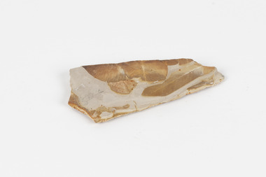 The Beechworth Burke Museum
Geological specimen - Fossil Leaves
... Hill, Ipswich in Queensland. Fossils leaves are formed when dead plants get buried by sediments like mud, sand, or volcanic ash. ...Hill, Ipswich in Queensland. Fossils leaves are formed when dead plants get buried by sediments like mud, sand, or volcanic ash. ...A fossil refers to any remains or traces of past life that are preserved in the rock. It could be remains of plants or animals. Fossil leaves are commonly found on different types of rocks. These fossils can go as far back as the Triassic Age just like the series of fossil plants collected at Denmark Hill, Ipswich in Queensland. Fossils leaves are formed when dead plants get buried by sediments like mud, sand, or volcanic ash. Often, it gets detached cleanly from stems along a special layer of weak cells, then twigs, and, less commonly, cones of conifers and fruits and seeds of flowering plants. Over time, the leaves or pieces of leaves get buried by more sediments and eventually gets 'lithified' or hardened into a rock. Erosions and mining can cause the rocks to break and reveal the fossils buried in it. Fossilisation frequently takes place at sites in the lowlands where deposits of clay, silt, sand are found. This is usually due to weathering and erosion of rocks. Fossil leaves can provide information about ancient Australia's way of living. It contributes to Victorian biodiversity records and its botanical collections. It also contributes information on the geographical profile of Victoria as fossilisation usually occur at estuaries and deltas of rivers, river flood plains, ponds and lakes. This specimen is part of a larger collection of geological and mineral specimens collected from around Australia (and some parts of the world) and donated to the Burke Museum between 1868-1880. A large percentage of these specimens were collected in Victoria as part of the Geological Survey of Victoria that begun in 1852 (in response to the Gold Rush) to study and map the geology of Victoria. Collecting geological specimens was an important part of mapping and understanding the scientific makeup of the earth. Many of these specimens were sent to research and collecting organisations across Australia, including the Burke Museum, to educate and encourage further study.Piece of light brown rock with fossilised leaves in shades of golden yellow and brown.Existing label: Fossil Leaves / Locality unknown / might be worth checking if this is Glossopteris, a Permian age plant. / C. William 16/4/21 geological specimen, geology, geology collection, burke museum, beechworth, fossil leaves, fossilization, 1868 geological survey of victoria, lithified, rocks, fossilised leaf, rock, fossils, leaves -
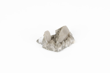 The Beechworth Burke Museum
Geological specimen - Calcite crystals
... Hill Mine...New South Wales...Charles Rasp...Syndicate of Seven...Volcanic...Hill mine is one of the largest mines working silver and lead in Australia and at its peak employed 6500 staff across 7.5km long of land. The site was founded in 1883 by Charles Rasp, where Rasp and 6 other men from various backgrounds came together to form the first BHP mine. It has become one of the most popular mining sites due to its abundance and longevity. The ore body was created 1685 million years ago due to volcanic...Hill mine is one of the largest mines working silver and lead in Australia and at its peak employed 6500 staff across 7.5km long of land. The site was founded in 1883 by Charles Rasp, where Rasp and 6 other men from various backgrounds came together to form the first BHP mine. It has become one of the most popular mining sites due to its abundance and longevity. The ore body was created 1685 million years ago due to volcanic ...Calcite is a common mineral and is found worldwide due to it being a primary component of many other rocks such as limestone and marble. It is a softer mineral that scratches easily and is often found colourless or with a cream/white shade but may show up in colours such as red, yellow, green, and violet. In sedimentary rocks calcite is often found in the form of invertebrate shells, making it an important biomineral. Calcite is used in many industries such as farming, building, and medicine. This particular specimen was found at Broken Hill mine in Broken Hill, New South Wales, Australia. Broken Hill mine is one of the largest mines working silver and lead in Australia and at its peak employed 6500 staff across 7.5km long of land. The site was founded in 1883 by Charles Rasp, where Rasp and 6 other men from various backgrounds came together to form the first BHP mine. It has become one of the most popular mining sites due to its abundance and longevity. The ore body was created 1685 million years ago due to volcanic activity causing heated seawater to flow up through the seafloor where it mixed with the cold water creating black sulphide precipitates. These then settled back onto the seafloor forming sediment layers rich in minerals. Over time the land eroded until it was discoverable by humans.Historically this specimen is significant due to the origin of its location. Broken Hill mine has a long history in both its location and its findings and has resulted in a variety of minerals being discovered at its site. It is beneficial in the understanding of the Australian landscape over millions of years. Due to its properties, calcite today is used in a multitude of different industries such as agriculture, construction, medicine, and farming.A small sized calcium, carbon and oxygen made mineral specimen in shades cream and greycalcite, mineral, limestone, marble, sedimentary, invertebrate shells, biomineral, farming, medicine, broken hill, broken hill mine, new south wales, charles rasp, syndicate of seven, volcanic activity, black sulphide precipitates, calcite crystals, beechworth museum, indigo shire, beechworth -
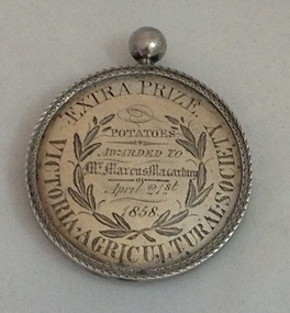 Koroit & District Historical Society
Victorian Agricultural Society Medal, 1850's
... Koroit & District Historical Society Victoria Park High Street Koroit great-ocean-road This medal, dated 1858, was awarded to local farmer Marcus Macartney by the Victorian Agricultural Society on the 21 April 1858, for the prize 'Potatoes The medal is of local historical significance"for its association with the early promotion of agriculture in Victoria through public shows and competitions in the 1850's; and its link to the emergence of the Koroit-Tower Hill area,with its rich volcanic soil, as a properous farming district, especially for potato-growing." ...This medal, dated 1858, was awarded to local farmer Marcus Macartney by the Victorian Agricultural Society on the 21 April 1858, for the prize 'PotatoesThe medal is of local historical significance"for its association with the early promotion of agriculture in Victoria through public shows and competitions in the 1850's; and its link to the emergence of the Koroit-Tower Hill area,with its rich volcanic soil, as a properous farming district, especially for potato-growing." (Helen Doyle, Significance Assesment: Koroit & District Historical Society.)Circular medal with small knob on top.Äround circumference/""EXTRA PRIZE VICTORIAN AGRICULTUREAL SOCIETY. Engraving on medal "Potatoes/Awarded To/Mr Marcus Macartney /April 21st/1858 Reverseägricultural shows, potatoes, koroit, tower hill -
 Victorian Interpretive Projects Inc.
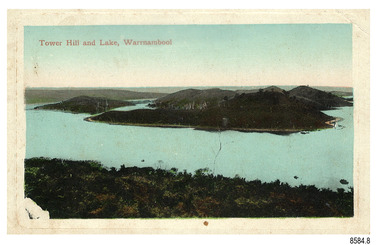
Photograph - Colour, Clare Gervasoni, Tower Hill, Victoria, 2013, 2013
... Tower Hill was formed around 30,000 years ago in a violent volcanic eruption. ...Tower Hill was formed around 30,000 years ago in a violent volcanic eruption. ...The Tower Hill Reserve is located inside a dormant volcano, and features a lake and wetlands. It became Victoria's first national park in 1892, but by the 1930s the early settlers had cleared much of the land for grazing, cropping and quarrying. In the 1960s the bare hills and islands were revegetated based in species identified from Eugene von Guerard's painting of Tower Hill. Tower Hill was formed around 30,000 years ago in a violent volcanic eruption. The initial eruption created the outer rim of the volcano, and later smaller eruptions formed the internal hills that are evident today. The layers of volcanic ash layers include artefacts relating to indigenous communites.A series of colour digital photographs showing Tower Hill, near Port Fairy, Victoria. Tower Hill is an extinct volcano.tower hill, volcano, extinct -
 Victorian Interpretive Projects Inc.
Photograph - Colour, Lisa Gervasoni, Tower Hill Volcanic Ash Layers, 2015, 25/12/2015
... Tower Hill Volcanic Ash Layers, 2015...Hill...Volcano...Volcanic...PO Box 93R, Redan, 3350 goldfields Tower Hill Volcano Volcanic ash Volcanic ash layers geology koroit Tower Hill Volcanic Ash Layers, 2015 Photograph - Colour Lisa Gervasoni ...tower hill, volcano, volcanic ash, volcanic ash layers, geology, koroit -
 Yarra City Council
Artwork, other - earthwork, ephemeral, Ivan Cindric, Earthwork Heron, 1997
... Outline of a Heron bird imprinted on a rolling hill in the landscape with volcanic stone (scoria). ...Outline of a Heron bird imprinted on a rolling hill in the landscape with volcanic stone (scoria). Earthwork Heron Artwork, other earthwork, ephemeral Ivan Cindric ..."This sculpture was inspired by the figures carved from the hillsides of the chalk downs in Britain. I wanted to produce a work that would become part of the landscape and was originally derived from the landscape. It is a white-faced heron which is a native water bird commonly found along the Merri Creek. The bird is looking upstream to the source of the creek and the other artworks along the creek."Made of scoria (a red-brown volcanic stone) laid in trenches, 'Earthwork Heron' was commissioned by the Merri Creek Management Committee as part of the Merri Creek Arts Plan and was donated to the City of Yarra in August 1997.Contemporary, LandartOutline of a Heron bird imprinted on a rolling hill in the landscape with volcanic stone (scoria). Accompanying plaque reads: 'This sculpture was inspired by the figures in the British Chalk Hills. I wanted Earthwork Heron to be derived from and become part of the landscape. The white feathered Heron a common native water bird is looking upstream to the creek's source." wildlife, landscape, ephemeral, landart, environment, site-specific -
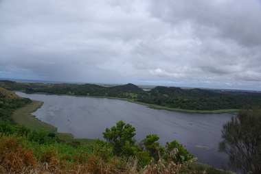
 Flagstaff Hill Maritime Museum and Village
Postcard - Scenic, Warrnambool, Tower Hill and Lake, Warrnambool, 1902-1929
... Hill Wildlife Reserve is in the crater of a dormant volcano. In 1892 the area was declared a National Park, the first in Victoria, preserving native animals and Indigenous plants. The rich volcanic...Hill Wildlife Reserve is in the crater of a dormant volcano. In 1892 the area was declared a National Park, the first in Victoria, preserving native animals and Indigenous plants. The rich volcanic ...The nine postcards in this set were donated together and date to the early 1900s. All but one postcard in this set shows images of Warrnambool, in the Western District of Victoria; the other has a London image. The postcards were all printed in Great Britain according to that country’s postal regulations. The fronts of all cards have titles printed in red. Most of the images on the cards are attributed to photographer Joseph Jordan and belong to the Jordan Series. The back of these cards has an outline for a postage stamp, a vertical dividing line and a heading on each side of the line to separate the Correspondence from the Address. Postcards or ‘correspondence cards’ appeared in Britain in 1894. They were plain cards with a space for the message on one side and an address on the other; regulations didn’t allow anything but the address to be written on the ‘address’ side. In 1902 the British regulations then allowed a picture to be printed on the front and the address on the back, so messages had to be written on the picture side. Soon, the regulations changed and the back was divided for a message and the address. Tower Hill and Lake, Warrnambool – Tower Hill Wildlife Reserve is in the crater of a dormant volcano. In 1892 the area was declared a National Park, the first in Victoria, preserving native animals and Indigenous plants. The rich volcanic soil in the area attracted early settlers including the families of Henry Giles, born at Tower Hill in 1858 and his wife Mary Jane (born Freckleton) born nearby at Cooramook in 1860. Henry and Mary worked in the local area where they also raised their six children. For a time, Henry was employed as a labourer on the Warrnambool Breakwater. Joseph Jordan - Joseph Jordan was born in 1841 in Leicester England. When he was 16 he joined the 7th Queen's Own Hussars and was sent to India at the outbreak of the mutiny. He took part in the relief of Lucknow and remained in India for eleven years. It was during this time that he became interested in photography. He was posted to New Zealand and later came to Victoria, becoming a sergeant major of the Mounted Rifles. In the mid-1880s he came to the Western district where he was responsible for establishing units of the Mounted Rifles in various country towns such as Dunkeld, Mortlake, Panmure, Bushfield, Koroit etc. He resigned from the army in 1889 and set up a professional photography studio in Liebig Street, Warrnambool. He became very well known in the Western District for family photographs, official photographs of local councillors and groups as well as views of local scenery. In 1891 he photographed the wrecked barque ‘Fiji’ at ‘Wrecks Beach’ near Princetown. His business was taken over by his son Arthur around 1917. Joseph was a keen rifle shot and in 1924 he donated the "Jordan Shield" as a prize to the Victorian Rifle Association. He was made a "Life Honorary Member" of the Warrnambool Returned Soldiers League and in 1933 he was recognised as being the oldest living soldier in Victoria. Joseph died in 1935 aged 95.The postcard of Tower Hill and Lake is connected to the location near Warrnambool where many of our early settlers lived and worked. One of these settlers was the Giles family, whose son Henry was born at Tower Hill. His family has donated many Victorian-era items which are now on display at Flagstaff Hill. Tower Hill National Park is the first place in Victoria to be named a National Park. As in the times when coastal trading ships brought passengers and cargo to the Port of Warrnambool, it continues to be a popular place to visit. Joseph Jordan is a significant figure in Warrnambool history as he helped to establish early units of the Mounted Rifles (G Company) in local towns during the late 1880's and later, photographed local scenes, groups and citizens of early Warrnambool.Postcard, one of nine, landscape orientation, coloured print within a rectangle and an impressed line around the image on the front. The picture shows several islands close together with hills around them and bushland in the foreground. There are dead trees amongst the vegetation and a sandy shore at the foot of some of the hills. The lower left corner shows what appears to be two white rails, possibly a lookout fence. There is no correspondence written on the card. The title is printed in red on the front and the back has inscriptions and outlines for a postage stamp. Jordan Series, printed in Great Britain. Front, in red: “Tower Hill Lake, Warrnambool” Back in green: “Jordan Series” “POST CARD” “PRINTED IN GREAT BRITAIN” “For correspondence” “The Address only to be written here”flagstaff hill maritime museum, flagstaff hill maritime village, flagstaff hill maritime museum and village, maritime museum, warrnambool, great ocean road, warrnambool and district, warrnambool scenes, local scenes, views of warrnambool, joseph jordan, jordan series, jordan photography, postcard, souvenir, correspondence, cameo postcard, tower hill, tower hill national park, victoria's first national park, henry giles, mary jane freckleton, breakwater, early settlers -
 Flagstaff Hill Maritime Museum and Village
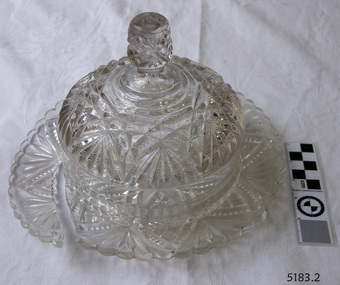
Domestic object - Butter Dish
... Flagstaff Hill Maritime Museum and Village 89 Merri Street Warrnambool great-ocean-road The art of making glass can be traced back to 2600 BC in Mesopotamia. Egyptians practised making glass around 2500 BC. Artificial glass first appeared in the Egyptian or the Mesopotamian civilization, whereas they used tools made out of volcanic glass obsidian in the Stone Age. ...The art of making glass can be traced back to 2600 BC in Mesopotamia. Egyptians practised making glass around 2500 BC. Artificial glass first appeared in the Egyptian or the Mesopotamian civilization, whereas they used tools made out of volcanic glass obsidian in the Stone Age. Ancient China, however, discovered how to make glass a little later. Glass beads are known to be one of the earliest products made out of glass. Their creation is thought to be primarily accidental. In the later Bronze Age, glassmaking came to a halt. Glass was a luxury material back then. Archaeological excavations suggest the use of glass in England during the middle ages. In the 10th century, stained glass found a place in cathedrals and windows of palaces. After the Renaissance, architectural methods changed substantially, leading to a decrease in stained glass as a building material. Domestic use of glass increased following the industrial revolution. Vessels, glass windows, and glass beads gained popularity in Europe during this period. During the 19th century, many people preferred glass windows and doors as a decorative option. In the late 19th century, some designers brought back stained glass in decorative windows. It was during this period that Mr Tiffany discovered several methods to make domed glass handicrafts. People discovered the true versatility of using glass as a building material only in the 20th century. With glassmaking technology receiving an industrial boom, you could produce several different types of glass. Toughened glass, laminated glass, bulletproof glass, and smart glass all boosted the use of glass in buildings. Today, several skyscrapers, small and big homes, and offices use glass in almost all aspects of construction and design. https://www.aisglass.com/glass-made-step-step-process/The invention and development of glass, both as domestic items and in building, has been nothing short of revolutionary. Prior to the use of glass for windows, the interior of buildings were extremely dark, even during sunny days. The use of glass domestic objects, that could be easily washed, led to improved hygiene.Moulded patterned glass butter dish. Base has been broken.None.flagstaff hill, warrnambool, shipwrecked-coast, flagstaff-hill, flagstaff-hill-maritime-museum, maritime-museum, shipwreck-coast, flagstaff-hill-maritime-village, glass, kitchen item, butter -
 Flagstaff Hill Maritime Museum and Village
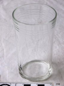
Domestic object - Glass
... Flagstaff Hill Maritime Museum and Village 89 Merri Street Warrnambool great-ocean-road The art of making glass can be traced back to 2600 BC in Mesopotamia. Egyptians practised making glass around 2500 BC. Artificial glass first appeared in the Egyptian or the Mesopotamian civilization, whereas they used tools made out of volcanic glass obsidian in the Stone Age. ...The art of making glass can be traced back to 2600 BC in Mesopotamia. Egyptians practised making glass around 2500 BC. Artificial glass first appeared in the Egyptian or the Mesopotamian civilization, whereas they used tools made out of volcanic glass obsidian in the Stone Age. Ancient China, however, discovered how to make glass a little later. Glass beads are known to be one of the earliest products made out of glass. Their creation is thought to be primarily accidental. In the later Bronze Age, glassmaking came to a halt. Glass was a luxury material back then. Archaeological excavations suggest the use of glass in England during the middle ages. In the 10th century, stained glass found a place in cathedrals and windows of palaces. After the Renaissance, architectural methods changed substantially, leading to a decrease in stained glass as a building material. Domestic use of glass increased following the industrial revolution. Vessels, glass windows, and glass beads gained popularity in Europe during this period. During the 19th century, many people preferred glass windows and doors as a decorative option. In the late 19th century, some designers brought back stained glass in decorative windows. It was during this period that Mr Tiffany discovered several methods to make domed glass handicrafts. People discovered the true versatility of using glass as a building material only in the 20th century. With glassmaking technology receiving an industrial boom, you could produce several different types of glass. Toughened glass, laminated glass, bulletproof glass, and smart glass all boosted the use of glass in buildings. Today, several skyscrapers, small and big homes, and offices use glass in almost all aspects of construction and design. https://www.aisglass.com/glass-made-step-step-process/The invention and development of glass, both as domestic items and in building, has been nothing short of revolutionary. Prior to the use of glass for windows, the interior of buildings were extremely dark, even during sunny days. The use of glass domestic objects, that could be easily washed, led to improved hygiene.Cylindrical drinking glass with stepped relief around lipNoneflagstaff hill, warrnambool, shipwrecked-coast, flagstaff-hill, flagstaff-hill-maritime-museum, maritime-museum, shipwreck-coast, flagstaff-hill-maritime-village, glass -
 Flagstaff Hill Maritime Museum and Village
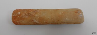
Equipment - Sharpening Stone, ca 1878
... Hill Maritime Museum and Village 89 Merri Street Warrnambool great-ocean-road The sharpening stone can also be referred to as a whetstone, oil stone or honing stone. It is a well-worn double-sided sharpening stone retrieved from the wreck site of the Loch Ard. It is used to grind and hone the edges of metal blades and tools. ‘Natural’ sharpening stones like this one are quarried from ancient sedimentary rock that has metamorphosed from clay and volcanic ...The sharpening stone can also be referred to as a whetstone, oil stone or honing stone. It is a well-worn double-sided sharpening stone retrieved from the wreck site of the Loch Ard. It is used to grind and hone the edges of metal blades and tools. ‘Natural’ sharpening stones like this one are quarried from ancient sedimentary rock that has metamorphosed from clay and volcanic ash to produce garnet crystals. Most modern stones are artificially produced, or ‘bonded’, abrasive stones, made by fusing clay and metal powder under heat and pressure. The softer yellow Corticule stone is found in thin vertical veins running through the more plentiful Belgian Blue rock. Coticule is a fine-grained and dense material that ‘cuts’ metal slowly but to a superior standard of sharpness and finish. The relatively coarser Belgian Blue is stronger and ‘cuts’ more quickly, but with a less polished finish. A double-sided whetstone is therefore valued for its increased durability (the harder BBW ‘backs’, or supports, the softer Coticule), and additional utility (the fine ‘grit’ of Coticule complements the coarser BBW to meet a range of sharpening needs). The blue-grey base of this stone is thinner than the remaining yellow Coticule on top. This suggests that the majority of grinding and honing work it has done on board the ship was for larger tools, rather than on surgical or shaving blades. Its rounded or spherical shaping may also be related to the ‘tumbling’ action of the sea on the ocean floor. History of the Loch Ard wreck: The Loch Ard got its name from ”Loch Ard” a loch that lies to the west of Aberfoyle, and the east of Loch Lomond. It means "high lake" in Scottish Gaelic. The vessel belonged to the famous Loch Line which sailed many vessels from England to Australia. The Loch Ard was built in Glasgow by Barclay, Curle & Co. in 1873, the vessel was a three-masted square-rigged iron sailing ship that measured 79.87 meters in length, 11.58 m in width, and 7 m in depth with a gross tonnage of 1693 tons with a mainmast that measured a massive 45.7 m in height. Loch Ard made three trips to Australia and one trip to Calcutta before its fateful voyage. Loch Ard left England on March 2, 1878, under the command of 29-year-old Captain Gibbs, who was newly married. The ship was bound for Melbourne with a crew of 37, plus 17 passengers. The general cargo reflected the affluence of Melbourne at the time. Onboard were straw hats, umbrellas, perfumes, clay pipes, pianos, clocks, confectionery, linen and candles, as well as a heavier load of railway irons, cement, lead and copper. There were other items included that were intended for display in the Melbourne International Exhibition of 1880. The voyage to Port Phillip was long but uneventful. Then at 3 am on June 1, 1878, Captain Gibbs was expecting to see land. But the Loch Ard was running into a fog which greatly reduced visibility. Captain Gibbs was becoming anxious as there was no sign of land or the Cape Otway lighthouse. At 4 am the fog lifted and a lookout aloft announced that he could see breakers. The sheer cliffs of Victoria's west coast came into view, and Captain Gibbs realised that the ship was much closer to them than expected. He ordered as much sail to be set as time would permit and then attempted to steer the vessel out to sea. On coming head-on into the wind, the ship lost momentum, the sails fell limp and Loch Ard's bow swung back towards land. Gibbs then ordered the anchors to be released in an attempt to hold their position. The anchors sank some 50 fathoms - but did not hold. By this time the ship was among the breakers and the tall cliffs of Mutton Bird Island rose behind. Just half a mile from the coast, the ship's bow was suddenly pulled around by the anchor. The captain tried to tack out to sea, but the ship struck a reef at the base of Mutton Bird Island, near Port Campbell. Waves subsequently broke over the ship and the top deck became loosened from the hull. The masts and rigging came crashing down knocking passengers and crew overboard. When a lifeboat was finally launched, it crashed into the side of Loch Ard and capsized. Tom Pearce, who had launched the boat, managed to cling to its overturned hull and shelter beneath it. He drifted out to sea and then on the flood tide came into what is now known as Lochard Gorge. He swam to shore, bruised and dazed, and found a cave in which to shelter. Some of the crew stayed below deck to shelter from the falling rigging but drowned when the ship slipped off the reef into deeper water. Eva Carmichael a passenger had raced onto the deck to find out what was happening only to be confronted by towering cliffs looming above the stricken ship. In all the chaos, Captain Gibbs grabbed Eva and said, "If you are saved Eva, let my dear wife know that I died like a sailor". That was the last Eva Carmichael saw of the captain. She was swept off the ship by a huge wave. Eva saw Tom Pearce on a small rocky beach and yelled to attract his attention. He dived in and swam to the exhausted woman and dragged her to shore. He took her to the cave and broke the open case of brandy which had washed up on the beach. He opened a bottle to revive the unconscious woman. A few hours later Tom scaled a cliff in search of help. He followed hoof prints and came by chance upon two men from nearby Glenample Station three and a half miles away. In a complete state of exhaustion, he told the men of the tragedy. Tom then returned to the gorge while the two men rode back to the station to get help. By the time they reached Loch Ard Gorge, it was cold and dark. The two shipwreck survivors were taken to Glenample Station to recover. Eva stayed at the station for six weeks before returning to Ireland by steamship. In Melbourne, Tom Pearce received a hero's welcome. He was presented with the first gold medal of the Royal Humane Society of Victoria and a £1000 cheque from the Victorian Government. Concerts were performed to honour the young man's bravery and to raise money for those who lost family in the disaster. Of the 54 crew members and passengers on board, only two survived: the apprentice, Tom Pearce and the young woman passenger, Eva Carmichael, who lost her family in the tragedy. Ten days after the Lochard tragedy, salvage rights to the wreck were sold at auction for £2,120. Cargo valued at £3,000 was salvaged and placed on the beach, but most washed back into the sea when another storm developed. The wreck of Lochard still lies at the base of Mutton Bird Island. Much of the cargo has now been salvaged and some items were washed up into Lochard Gorge. Cargo and artefacts have also been illegally salvaged over many years before protective legislation was introduced in March 1982. One of the most unlikely pieces of cargo to have survived the shipwreck was a Minton majolica peacock- one of only nine in the world. The peacock was destined for the Melbourne 1880 International Exhibition. It had been well packed, which gave it adequate protection during the violent storm. Today the Minton peacock can be seen at the Flagstaff Hill Maritime Museum in Warrnambool. From Australia's most dramatic shipwreck, it has now become Australia's most valuable shipwreck artifact and is one of very few 'objects' on the Victorian State Heritage Register. The shipwreck of the Loch Ard is of significance for Victoria and is registered on the Victorian Heritage Register ( S 417). Flagstaff Hill has a varied collection of artefacts from Loch Ard and its collection is significant for being one of the largest accumulation of artefacts from this notable Victorian shipwreck of which the subject items are a small part. The collections objects give us a snapshot of how we can interpret the story of this tragic event. The collection is also archaeologically significant as it represents aspects of Victoria's shipping history that allows us to interpret Victoria's social and historical themes of the time. Through is associated with the worst and best-known shipwreck in Victoria's history. A sharpening stone is also called a whetstone, oil, or honing stone. The stone is a worn double-sided rectangular block with rounded corners. There is a clear delineation between its coarser Belgian Blue base (grey colour) and its finer Belgian Coticule face (yellow colour). It bears sedimentary encrustation over one-third of its surface. flagstaff hill, warrnambool, shipwrecked coast, flagstaff hill maritime museum, maritime museum, shipwreck coast, flagstaff hill maritime village, great ocean road, loch line, loch ard, captain gibbs, eva carmichael, tom pearce, glenample station, mutton bird island, loch ard gorge, sharpening stone, whetstone, oilstone, double-sided stone, belgian coticule, belgian blue whetstone, oil stone, honing stone -
 Federation University Historical Collection
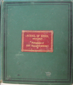
Book - Photo album, Photographs of New Zealand Scenery, 1886, 1886 (exact)
... hill harison's cove milford sound tall ship hydraulic mining hale's arm james oddie (donor) george hook stephen carey Lake Rotomahana Each photo has a caption. Large green album containing numerous B/W original photographs of New Zealand, especially volcanos. - Includes Pink and White Terraces (no longer in existance). Photos were taken before and after volcanic ...Before Mt Tarawera erupted, the Pink and White Terraces at Lake Rotomahana in New Zealand’s North Island, were considered one of the wonders of the world. Tourists came to soak in the thermal hot pools and view the marble-like terraces. Due to a volcanic eruption of Mt Tarawera On June 10 1886, between 108-120 people were killed and several settlements were destroyed. It also destroyed the world-famous Pink and White Terraces. The terraces became a crater over 100 metres deep. Within 15 years it filled with water, forming a much larger new Lake Rotomahana. The chain of craters at Waimangu became the site of many new geothermal features, including Waimangu Geyser, the largest in the world, and New Zealand’s largest hot spring, Frying Pan Lake. The Burton brothers (photographers), Alfred Burton was born in 1834 in Leicester and died in 1914 in Dunedin. His brother Walter Burton was born in 1836 and died in 1880. Many of the Burton Brothers' works and original equipment were collected by Dunedin photographer and historian Hardwicke Knight, and are now housed in the Museum of New Zealand Te Papa Tongarewa in Wellington. This album was donated to the Ballarat School of Mines Museum by James Oddie in 1887. (See Cat. No. 458, No. 1720) Alfred Burton was born in 1834 at Leicester and died at Dunedun, New Zealand, in 1914. Walter Burton was born in 1836, and died in 1889. Large green album containing numerous B/W original photographs of New Zealand, especially volcanos. - Includes Pink and White Terraces (no longer in existance). Photos were taken before and after volcanic eruption. A recent inclusion is article on the terraces by Federation University's George Hook and Stephen Carey.Each photo has a caption.pink terrace, white terrace, new zealand, sumner, burton bros, rotokakahi wairoa, rotomahana crater, tikitapu bush, wanganui bridge, maori, canoe, volcano, mount tarawara, james oddie, ballarat school of mines museum, eruption, waterfall, bridge, sulphur pool, crater, mt tarawera, tikitapu lake, rananga house, wairoa, waikato, maori church wairoa, ganaru, taherepokiore, golden bay, paterson, dowling st dunedin, rocky hill, harison's cove, milford sound, tall ship, hydraulic mining, hale's arm, james oddie (donor), george hook, stephen carey, lake rotomahana -
 Federation University Historical Collection
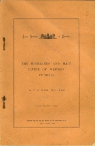
Booklet, Thomas Stephen Hart, The Highlands and Main Divide of Western Victoria, 1907, 12/12/1907
... volcanic plains...waterways...lal lal basin...yarrowee creek...ballarat common...lava flow...wendouree...warrenheip...ballarat plateau...mt elephant...grampians...t.s. hart...mt buangor...mt beckworth...mt misery...mt bolton...lal lal iron ored...mt ararat...mt wiliam...mt cole...burrumbeet...mt warrenheip...daylesford...waubra...ercildoun gap...smythesdale...lal lal falls...parwan valley...burrumbeet creek...staffordshire reef...pyranees...bacchus marsh...rowsley fault...ben nevis...avoca hill...Hart was a teacher at the Ballarat School of Mines, and a member of the Ballarat Field Naturalists Club thomas hart thomas s. hart ballarat school of mines ballarat field naturalists club royal society of victoria western victoria ballarat great dividing range mt william volcano volcanic plains waterways lal lal basin yarrowee creek ballarat common lava flow wendouree warrenheip ballarat plateau mt elephant grampians t.s. hart mt buangor mt beckworth mt misery mt bolton lal lal iron ored mt ararat mt wiliam mt cole burrumbeet mt warrenheip daylesford waubra ercildoun gap smythesdale lal lal falls parwan valley burrumbeet creek staffordshire reef pyranees bacchus marsh rowsley fault ben nevis avoca hill landsborough hill mt blowhard weatherboard mclean's hill Fyan's Creek thomas stephen hart lal lal Article with illustrations published by the Royal Society of Victoria by Thomas S. ...Thomas S. Hart was a teacher at the Ballarat School of Mines, and a member of the Ballarat Field Naturalists ClubArticle with illustrations published by the Royal Society of Victoria by Thomas S. Hart. The following plates are included: Fig 1. The Main Divide and some of the transverse ridges Fig 2. Hills on and near the Divide at the Ercildoun and Ascot Gaps Fig. 3. Profile of the Divide at Ascot Gap. Fig. 4. Sketch of the Hills west and north-west from Mt Buninyong - - The divide in Ascot Gap from Mt Blowhard (Serra Range, Mt William, Mt Ararat, Larne Gerin, Ben Major, Mt Cole, Mt Misery, Mt Bolton) Fig. 5. Diagram to illustrate the possible courses of the leads south of the present Divide - Burrumbeet Basin (Smythesdale, Ballarat, Lal Lal , Mt Doran, egerton, Parwan Creet, Rowsley Fault, Eastern Plateau) Fig. 6. Diagramatic cross section of the grampians, south of Hall's Gap. Profile of the Pyranees, from maiden Hill - Diagramatic Section of the Grampians south of Hall's Gap. (Mt Cole, Mt Mitchell, Ben Major, Ben More, Avoca Hill, Hall's Gap.) Fig. 7. Profile of the Pyrenees as seen from Maiden Hill near Waubra.thomas hart, thomas s. hart, ballarat school of mines, ballarat field naturalists club, royal society of victoria, western victoria, ballarat, great dividing range, mt william, volcano, volcanic plains, waterways, lal lal basin, yarrowee creek, ballarat common, lava flow, wendouree, warrenheip, ballarat plateau, mt elephant, grampians, t.s. hart, mt buangor, mt beckworth, mt misery, mt bolton, lal lal iron ored, mt ararat, mt wiliam, mt cole, burrumbeet, mt warrenheip, daylesford, waubra, ercildoun gap, smythesdale, lal lal falls, parwan valley, burrumbeet creek, staffordshire reef, pyranees, bacchus marsh, rowsley fault, ben nevis, avoca hill, landsborough hill, mt blowhard, weatherboard, mclean's hill, fyan's creek, thomas stephen hart, lal lal -
 Bendigo Historical Society Inc.
Newspaper - Newspaper articles by Ken Arnold, Out &About, 2000 - 2003
... Hill 1.9.00 13. Cairn. Carisbrook 8.9.00 14. Commemorative Markers. Taradale 15.9.00 15. Burke Monument. Castlemaine 22.9.00 16. Cairn. Harcourt area 29.9.00 17. Cairn Marks Gold Route 6.10.00 18. Volcanic...Hill 1.9.00 13. Cairn. Carisbrook 8.9.00 14. Commemorative Markers. Taradale 15.9.00 15. Burke Monument. Castlemaine 22.9.00 16. Cairn. Harcourt area 29.9.00 17. Cairn Marks Gold Route 6.10.00 18. Volcanic ...Ken Arnold is a Bendigo author and publisher.A series of one hundred and thirty-five articles written by Ken Arnold and published in the Bendigo Weekly between 2000 and 2003. Each article has a topic or theme and includes historical information and details. Each article includes a photograph. The articles are stored in a red vinyl covered two ring A5 folder. Index below. Number Article Name Date 1. Centenary of Victoria 19.5.00 2. Storm Water Drain 26.5.00 3. Granite Rollers 2.6.00 4. Poverty Mine 9.6.00 5. Golden Monument. St Arnaud 16.6.00 6. Turner Statue 7.7.00 7. Gold Monument. High St Golden Square 30.6.00 8. Gold Monument. Howard Square Bendigo 14.7.00 9. Lansell Statue 21.7.00 10. Shelbourne West School 18.8.00 11. Mologa’s State Schools 25.8.00 12. Salinity Stone. Pyramid Hill 1.9.00 13. Cairn. Carisbrook 8.9.00 14. Commemorative Markers. Taradale 15.9.00 15. Burke Monument. Castlemaine 22.9.00 16. Cairn. Harcourt area 29.9.00 17. Cairn Marks Gold Route 6.10.00 18. Volcanic Rock Cairn. Woodstock 13.10.00 19. Garfield Water Wheel 20.10.00 20. Anticline. Castlemaine 27.10.00 21. Lawson Bridge 10.11.00 22. Plaque. Sutton Grange area 17.11.00 23. Memorial Cairn. Maryborough 1.12.00 24. Lonely Grave 8.12.00 25. Moonlight Flat Church 5.1.01 26. Historic Church. Near Tullaroop reservoir 12.1.01 27. Granite Statue. Castlemaine 19.1.01 28. Marker. Near Tullaroop reservoir 25.1.01 29. Church Site. Mologa 2.2.01 30. Church Site. Mologa 9.2.01 31. Plaque. Mologa 16.2.01 32. Mincha School 23.2.01 33. Historic Marker. Mincha 2.3.01 34. Expedition Marker. Pyramid Hill 9.3.01 35. Irrigation Marker. Tragowel 16.3.01 36. Mologa School Sites 23.3.01 37. Cairn. Pyramid Hill 30.3.01 38. Plaque. Pyramid Hill 6.4.01 39. Bristol Hill Lookout Tower. Maryborough 12.4.01 40. Eppalock Reservoir 20.4.01 41. Colbinabbin Cairn 27.4.01 42. Mount Macedon Cross 4.5.01 43. Memorial Gateway. Macedon 11.5.01 44. Cairn. Daylesford 18.5.01 45. Grave. Carlsruhe 25.5.01 46. Water Tower. Elmore 1.6.01 47. State School Site. Glenalbyn 8.6.01 48. Cairn. Kanya 15.6.01 49. Lonely Grave. Wedderburn 22.6.01 50. Church Cairn. Glenalbyn 29.6.01 51. Kamarooka School 6.7.01 52. Granite Marker. Moyston 13.7.01 53. Memorial Park. Kerang 20.7.01 54. Water Plaque. Bears Lagoon 27.7.01 55. Cemetery. Bears Lagoon 3.8.01 56. Race Monument 10.8.01 57. Cairn. Pyalong 17.8.01 58. Cairn. In memory of Edward Parker 24.8.01 59. Mt Macedon 31.8.01 60. Mt Macedon Cairn 7.9.01 61. Expedition Pass. Chewton 14.9.01 62. Granite Archway. St Arnaud 21.9.01 63. Stuart Mill School Site 28.9.01 64. School Site. Beazley’s Bridge 5.10.01 65. Fosterville 12.10.01 66. Barnadown 19.10.01 67. Salisbury School Site 26.10.01 68. Cricket History at Wattle Flat 2.11.01 69. School Site. Waterloo Plains 9.11.01 70. Carapooee School Site 11.01 71. Turkish Gun. Maldon 11.01 72. Kooreh 30.11.01 73. Marnoo East School 7.12.01 74. Bulgana Site 14.12.01 75. Emu School 21.12.01 76. Kooroocheang 4.1.02 77. Church Site. Gre Gre North 11.1.02 78. Carmens Tunnel. Maldon 18.1.02 79. Monument. Maldon 25.1.02 80. Woodfull Plaques. Maldon 1.2.02 81. Carapooee. St Peters Anglican Church 8.2.02 82. Cairn. Kingower 15.2.02 83. Cob & Co Stopover. Rheola 22.2.02 84. Flynn Monument 1.3.02 85. The Welcome Stranger. Moliagul 8.3.02 86. Campbell’s Creek Reserve 15.3.02 87. Mine. Fryerstown 22.3.02 88. Escott Grave. Near Chewton 28.3.02 89. School No 808. Kurting area 5.4.02 90. Graves. Bendigo Creek 10.5.02 91. School. Fish Point, Benjeroop North 17.5.02 92. Old Township. Diggora 24.5.02 93. Diggora West (1) 31.5.02 94. Diggora West (2) 7.6.02 95. School No 2735. Gower East 14.6.02 96. Pannoomilloo 21.6.02 97. Kamarooka Settlement 28.6.02 98. Mincha West State School No 1931 5.7.02 99. Bridges. Arnold 12.7.02 100. Woodvale 19.7.02 101. A Famous Son of Raywood. Jack Donaldson 26.7.02 102. Tandarra Area Schools 2.8.02 103. Dingee 9.8.02 104. Avonmore 30.8.02 105. Myola East School 6.9.02 106. Colbinabbin West 13.9.02 107. Colbinabbin West School 20.9.02 108. Runnymede area 27.9.02 109. Wanalta 4.10.02 110. School Sites. Between Wanalta and Carop 11.10.02 111. Burramboot 18.10.02 112. Kangaroo Chair. 25.10.02 113. Mincha South 1.11.02 114. Woodlands Church 8.11.02 115. School site. Sylvaterre 15.11.02 116. Terrick Terrick 22.11.02 117. Leitchville 29.11.02 118. Pennyweight Cemetery. Castlemaine 6.12.02 119. Mincha Area 13.12.02 120. Musk School 20.12.02 121. Dowie Park. Carisbrook 3.1.03 122. Neereman School Site 10.1.03 123. Bald Rock 17.1.03 124. Sylvaterre School Site 24.1.02 125. Carlsruhe 31.1.02 126. Athenaeum. Maldon 7.2.03 127. School. Mincha West 14.2.03 128. Yarraberb 21.2.03 129. Settlement Marker. Ravenswood Estate 28.2.03 130. Comini Reserve. Ravenswood 7.3.03 131. Ironbark and Gold Track. Whroo 14.3.03 132. Burke and Wills Obelisk. Castlemaine 21.3.03 133. James Cook Statue. Myers St Bendigo 28.3.03 134. St Marys Church. Axedale 4 .4.03 135. Butter Factory Site. Warragamba 11.4.03 events, monuments, historical sites, landmarks -
 Sunshine and District Historical Society Incorporated
Archive - Aboriginal First Nation and Archaelogy
... Newspaper Article Brimbank Independent 6 May 1997 Aboriginal reconciliation meeting at St Albans|Typed Letter 8 June 1982 Victoria Archaelogical Survey|Typed Letter 10 June 1982 Survey of Archaelogical Sites in the Melbourne Metropolitan Area|Newspaper Article Herald Sun 18 September 1994 Before the white man|Newspaper Article Advocate 30 June 1999 We re rockin on Rock of Ages - Volcanic rock from the banks of the Kororoit Creek|Newspaper Article Advocate 20 June 2000 History revealed Aboriginal artefacts on a West Sunshine site|Typed Report First Residents of Melbourne's Western Region by Gary Presland|Brochure First Residents of Melbourne's Western Region by Gary Presland|Flyer The Melbourne and Metropolitan Archaeological Survey|Flyer John Bateman and the Aborigines|Flyer and Time A Celebration of Victoria's Submerged Archaelogical Heritage|Flyer Aborigines in the Gellibrand Hill area|Program 9 Octoberr 1981 Archaelogy|Handmade Map 1997 Brimbank Dreamtime Festival 22nd March 1997 - Map of Festival Layout at Brimbank Park|Newspaper Article Advocate 20 April 2013 Call for leaders to take a stand|Typed Letter 2010 Preliminary Report on Aboriginal Artefacts found in Albion and Ardeer by Robert Jackson|Brimbank Together Yes Acknowledging our history embracing our future poster - Use by Brimbank Council at The Hunt Club Community Centre|Newspaper Article Weekly Times 2 July 2002 A cultural experience for students Maribyrnong Primary School|Newspaper Article Living Museum 10 October 2001 Project forges links between cultures|The Advocate 20th April - Call for leaders to take a stand Colleen Marion|Booklet The Voice to Parliament|Booklet The Voice to Parliament Your Questions answered|Brochure Yes23 It's time to recognise Aboriginal and Torres Strait Islander Peoples in the Consititution throug a voice information sheets|Your official referendum booklet|Flyer How to vote yes campaign cards|Newspaper Article Herald Sun 15 October 2023 Time to Unite after the referendum defeat|Newspaper Article Herald Sun 16 October 2023 How Australia Voted|Brochure Brimbank council wants a better future for Aboriginal and Torres Strait Islander people|Brochure council for Aboriginal Reconciliation Working Together|Email La Trobe University Branch 4 March 2001|Typed Letter 13 March 1991 The Aboriginal Programme Exchange|Typed Letter 20 April 2000 Union of Australian Women|Typed Letter August 2000 Union of Australian Women Newsletter|Magazine Dissent Spring 2000 Aborigines reconciliation racial prejudice|Brochure Talking Together Women and Reconciliation|Brochure A National Action Network|Brochure High Court Decision on Native Title|Brochure Running Discussion Groups|Brochure Dealing with the Media|Brochure Contacts and Resources|Program The Western Metropolitan Region NAIDOC Program 2007|Newspaper Article The Age 25 May 1991 The Jawoyns troubled dreaming|Newsletter AEQUA Equal Employment Opportunity Newsletter 12 August 1981 Aboriginal employment in the APS on the up|Photocopy of Photograph Off Opie Road near Brachnell Place|Brochure Brimbank News Issue 10 2023 Be Bold Festival 7 October 2023|Typed Notes Uluru Statement from the Heart|Newspaper Article The Age 18 January 2001 William Barak|Newspaper Article The Star 17th October 2006 Special day for youth Karen Jackson|Newspaper Article Lalor Star March 1980 Aboriginal Treaty|Typed Letter Womens International Leagure for Peace and Freedom November 1979|Newspaper Article The Age 17 April 1997 Rednecks using Wik debate to grab new rights|Flyer Support Workers Claims for Stolen Wages and Return the Stolen wages for Workers and their families and Support Wage Justice Return the Stolen Wages|Handwritten Letter from Leo Prestia 27 January|List of Aboriginal Organisatons February 2004|Newspaper Article A Saturday Reflection|Postcard Pitchi Richi Sanctuary Alice Springs|Postcard Pitchi Richi Sanctuary Alice Spring|Invitation The Mayor and Councillors of Moreland City Council Connections Land and people|Notes Address Selina Aborignes|Booklet Recognition The Way forward An Issues paper from the Ausralian Catholic Social Justice Council|Newspaper Article The Age 21 January 1980 Signs of ancient man found in threatened valley|Form Australians for Native title reconciliation|Booklet Vic Uni News June 1997 Jindi woraback joining together|Newspaper Article The Age 17 April 1997 Black network hears Wik plan|Booklet Australian Institute for a Just Sustainable Peaceful Future Native Title Implications for Land management April 1997 Discussion Paper Number 11|Typed Notes Parliament of Australia Department of the Parliamentary Library current Information Digest Education and Welfare 14 January 1973 Aborigines Government Policy|Koori music and the Multicultural choir 13 July|Typed Notes 4 February 2004|Flyer State of Shock A new film by David Bradbury|Newspaper Article 21 October 1997 The Age Metro Arts and Life Heritage voting for a Trust you can trust6|Typed Letter from Parliament of Australia The Senate Hon Margaret Reynolds 15 September 1997 Native title Amendment bill 1997|Typed notes What are the International implications of Australias proposed legislative response to the Wik decision 16 May 1997|Newspaper Article The Age 11 October 1980 CRA and the Aborigines|Newspaper Article The Age 27 October 1980 Lost languages of the Aborigine|Program Western Metropolitan Region NAIDOC Committee 6 October 2004|Typed Notes How the English Language is used to put Aborigines down Deny us rights or Is Employed as a Political Tool Against Us|Flyer Australias for Reconciliation Study Circle The Footscray Community Arts Centre|Newspaper Article Weekly Times 4 December 2001 Smoking marks opening|Flyer Save The Racial Discrimination Act The Law for All of Us|Flyer Freedom fund for 1988 Dont Celebrate 1988 White Australia Has a Black History|Typed Notes 4 May 1997 Area Meeting on Aboriginal Reconciliation 20 May 1997 Why Reconciliation|Newspaper Article Sunday Press 17 July 1988 Hes black hes white and hes Browned off|Handwritten list Morning Tea with Yolande Klempprier 5 December 1979|Typed Notes Interim Consultative Committee Western Region Community Legal Centre|Brochure Aboriginal Myths and Legends from the Goldfields to the South West of Western Australia|Brochure Messagestick Conserve or Destroy May 1980 Voume 5 No 1|Brochure Aboringinal Women's Task Force "We need to know what you think"|Newspaper Article The Age 27th February 1980 Aboriginal skeleton found by workmen Barries Rd Melton|Newspaper Article 18th September 1985 Only maternal instricts have saved Aboriginal race from destruction says Hollows|Newspaper Article Star Weekly 26th March 2024 New Indigenous name for Sydenham Park "Yaluk barring Park"|Newspaper Article Star Weekly 30th July 2024 - New name for park|Newspaper Artilce 9th January 2024 Abandoning January 26 - Brimbank Council will no longer hold citizenship cermonies on January 26...Aborigine Aboriginal First Nation Newspaper Article Brimbank Independent 6 May 1997 Aboriginal reconciliation meeting at St Albans|Typed Letter 8 June 1982 Victoria Archaelogical Survey|Typed Letter 10 June 1982 Survey of Archaelogical Sites in the Melbourne Metropolitan Area|Newspaper Article Herald Sun 18 September 1994 Before the white man|Newspaper Article Advocate 30 June 1999 We re rockin on Rock of Ages - Volcanic rock from the banks of the Kororoit Creek|Newspaper Article Advocate 20 June 2000 History revealed Aboriginal artefacts on a West Sunshine site|Typed Report First Residents of Melbourne's Western Region by Gary Presland|Brochure First Residents of Melbourne's Western Region by Gary Presland|Flyer The Melbourne and Metropolitan Archaeological Survey|Flyer John Bateman and the Aborigines|Flyer and Time A Celebration of Victoria's Submerged Archaelogical Heritage|Flyer Aborigines in the Gellibrand Hill area|Program 9 Octoberr 1981 Archaelogy|Handmade Map 1997 Brimbank Dreamtime Festival 22nd March 1997 - Map of Festival Layout at Brimbank Park|Newspaper Article Advocate 20 April 2013 Call for leaders to take a stand|Typed Letter 2010 Preliminary Report on Aboriginal Artefacts found in Albion and Ardeer by Robert Jackson|Brimbank Together Yes Acknowledging our history embracing our future poster - Use by Brimbank Council at The Hunt Club Community Centre|Newspaper Article Weekly Times 2 July 2002 A cultural experience for students Maribyrnong Primary School|Newspaper Article Living Museum 10 October 2001 Project forges links between cultures|The Advocate 20th April - Call for leaders to take a stand Colleen Marion|Booklet The Voice to Parliament|Booklet The Voice to Parliament Your Questions answered|Brochure Yes23 It's time to recognise Aboriginal and Torres Strait Islander Peoples in the Consititution throug a voice information sheets|Your official referendum booklet|Flyer How to vote yes campaign cards|Newspaper Article Herald Sun 15 October 2023 Time to Unite after the referendum defeat|Newspaper Article Herald Sun 16 October 2023 How Australia Voted|Brochure Brimbank council wants a better future for Aboriginal and Torres Strait Islander people|Brochure council for Aboriginal Reconciliation Working Together|Email La Trobe University Branch 4 March 2001|Typed Letter 13 March 1991 The Aboriginal Programme Exchange|Typed Letter 20 April 2000 Union of Australian Women|Typed Letter August 2000 Union of Australian Women Newsletter|Magazine Dissent Spring 2000 Aborigines reconciliation racial prejudice|Brochure Talking Together Women and Reconciliation|Brochure A National Action Network|Brochure High Court Decision on Native Title|Brochure Running Discussion Groups|Brochure Dealing with the Media|Brochure Contacts and Resources|Program The Western Metropolitan Region NAIDOC Program 2007|Newspaper Article The Age 25 May 1991 The Jawoyns troubled dreaming|Newsletter AEQUA Equal Employment Opportunity Newsletter 12 August 1981 Aboriginal employment in the APS on the up|Photocopy of Photograph Off Opie Road near Brachnell Place|Brochure Brimbank News Issue 10 2023 Be Bold Festival 7 October 2023|Typed Notes Uluru Statement from the Heart|Newspaper Article The Age 18 January 2001 William Barak|Newspaper Article The Star 17th October 2006 Special day for youth Karen Jackson|Newspaper Article Lalor Star March 1980 Aboriginal Treaty|Typed Letter Womens International Leagure for Peace and Freedom November 1979|Newspaper Article The Age 17 April 1997 Rednecks using Wik debate to grab new rights|Flyer Support Workers Claims for Stolen Wages and Return the Stolen wages for Workers and their families and Support Wage Justice Return the Stolen Wages|Handwritten Letter from Leo Prestia 27 January|List of Aboriginal Organisatons February 2004|Newspaper Article A Saturday Reflection|Postcard Pitchi Richi Sanctuary Alice Springs|Postcard Pitchi Richi Sanctuary Alice Spring|Invitation The Mayor and Councillors of Moreland City Council Connections Land and people|Notes Address Selina Aborignes|Booklet Recognition The Way forward An Issues paper from the Ausralian Catholic Social Justice Council|Newspaper Article The Age 21 January 1980 Signs of ancient man found in threatened valley|Form Australians for Native title reconciliation|Booklet Vic Uni News June 1997 Jindi woraback joining together|Newspaper Article The Age 17 April 1997 Black network hears Wik plan|Booklet Australian Institute for a Just Sustainable Peaceful Future Native Title Implications for Land management April 1997 Discussion Paper Number 11|Typed Notes Parliament of Australia Department of the Parliamentary Library current Information Digest Education and Welfare 14 January 1973 Aborigines Government Policy|Koori music and the Multicultural choir 13 July|Typed Notes 4 February 2004|Flyer State of Shock A new film by David Bradbury|Newspaper Article 21 October 1997 The Age Metro Arts and Life Heritage voting for a Trust you can trust6|Typed Letter from Parliament of Australia The Senate Hon Margaret Reynolds 15 September 1997 Native title Amendment bill 1997|Typed notes What are the International implications of Australias proposed legislative response to the Wik decision 16 May 1997|Newspaper Article The Age 11 October 1980 CRA and the Aborigines|Newspaper Article The Age 27 October 1980 Lost languages of the Aborigine|Program Western Metropolitan Region NAIDOC Committee 6 October 2004|Typed Notes How the English Language is used to put Aborigines down Deny us rights or Is Employed as a Political Tool Against Us|Flyer Australias for Reconciliation Study Circle The Footscray Community Arts Centre|Newspaper Article Weekly Times 4 December 2001 Smoking marks opening|Flyer Save The Racial Discrimination Act The Law for All of Us|Flyer Freedom fund for 1988 Dont Celebrate 1988 White Australia Has a Black History|Typed Notes 4 May 1997 Area Meeting on Aboriginal Reconciliation 20 May 1997 Why Reconciliation|Newspaper Article Sunday Press 17 July 1988 Hes black hes white and hes Browned off|Handwritten list Morning Tea with Yolande Klempprier 5 December 1979|Typed Notes Interim Consultative Committee Western Region Community Legal Centre|Brochure Aboriginal Myths and Legends from the Goldfields to the South West of Western Australia|Brochure Messagestick Conserve or Destroy May 1980 Voume 5 No 1|Brochure Aboringinal Women's Task Force "We need to know what you think"|Newspaper Article The Age 27th February 1980 Aboriginal skeleton found by workmen Barries Rd Melton|Newspaper Article 18th September 1985 Only maternal instricts have saved Aboriginal race from destruction says Hollows|Newspaper Article Star Weekly 26th March 2024 New Indigenous name for Sydenham Park "Yaluk barring Park"|Newspaper Article Star Weekly 30th July 2024 - New name for park|Newspaper Artilce 9th January 2024 Abandoning January 26 - Brimbank Council will no longer hold citizenship cermonies on January 26 Collection documents relating to Aboriginal First Nation and Archaelogy in the district Archive Aboriginal First Nation and Archaelogy ...Newspaper Article Brimbank Independent 6 May 1997 Aboriginal reconciliation meeting at St Albans|Typed Letter 8 June 1982 Victoria Archaelogical Survey|Typed Letter 10 June 1982 Survey of Archaelogical Sites in the Melbourne Metropolitan Area|Newspaper Article Herald Sun 18 September 1994 Before the white man|Newspaper Article Advocate 30 June 1999 We re rockin on Rock of Ages - Volcanic rock from the banks of the Kororoit Creek|Newspaper Article Advocate 20 June 2000 History revealed Aboriginal artefacts on a West Sunshine site|Typed Report First Residents of Melbourne's Western Region by Gary Presland|Brochure First Residents of Melbourne's Western Region by Gary Presland|Flyer The Melbourne and Metropolitan Archaeological Survey|Flyer John Bateman and the Aborigines|Flyer and Time A Celebration of Victoria's Submerged Archaelogical Heritage|Flyer Aborigines in the Gellibrand Hill area|Program 9 Octoberr 1981 Archaelogy|Handmade Map 1997 Brimbank Dreamtime Festival 22nd March 1997 - Map of Festival Layout at Brimbank Park|Newspaper Article Advocate 20 April 2013 Call for leaders to take a stand|Typed Letter 2010 Preliminary Report on Aboriginal Artefacts found in Albion and Ardeer by Robert Jackson|Brimbank Together Yes Acknowledging our history embracing our future poster - Use by Brimbank Council at The Hunt Club Community Centre|Newspaper Article Weekly Times 2 July 2002 A cultural experience for students Maribyrnong Primary School|Newspaper Article Living Museum 10 October 2001 Project forges links between cultures|The Advocate 20th April - Call for leaders to take a stand Colleen Marion|Booklet The Voice to Parliament|Booklet The Voice to Parliament Your Questions answered|Brochure Yes23 It's time to recognise Aboriginal and Torres Strait Islander Peoples in the Consititution throug a voice information sheets|Your official referendum booklet|Flyer How to vote yes campaign cards|Newspaper Article Herald Sun 15 October 2023 Time to Unite after the referendum defeat|Newspaper Article Herald Sun 16 October 2023 How Australia Voted|Brochure Brimbank council wants a better future for Aboriginal and Torres Strait Islander people|Brochure council for Aboriginal Reconciliation Working Together|Email La Trobe University Branch 4 March 2001|Typed Letter 13 March 1991 The Aboriginal Programme Exchange|Typed Letter 20 April 2000 Union of Australian Women|Typed Letter August 2000 Union of Australian Women Newsletter|Magazine Dissent Spring 2000 Aborigines reconciliation racial prejudice|Brochure Talking Together Women and Reconciliation|Brochure A National Action Network|Brochure High Court Decision on Native Title|Brochure Running Discussion Groups|Brochure Dealing with the Media|Brochure Contacts and Resources|Program The Western Metropolitan Region NAIDOC Program 2007|Newspaper Article The Age 25 May 1991 The Jawoyns troubled dreaming|Newsletter AEQUA Equal Employment Opportunity Newsletter 12 August 1981 Aboriginal employment in the APS on the up|Photocopy of Photograph Off Opie Road near Brachnell Place|Brochure Brimbank News Issue 10 2023 Be Bold Festival 7 October 2023|Typed Notes Uluru Statement from the Heart|Newspaper Article The Age 18 January 2001 William Barak|Newspaper Article The Star 17th October 2006 Special day for youth Karen Jackson|Newspaper Article Lalor Star March 1980 Aboriginal Treaty|Typed Letter Womens International Leagure for Peace and Freedom November 1979|Newspaper Article The Age 17 April 1997 Rednecks using Wik debate to grab new rights|Flyer Support Workers Claims for Stolen Wages and Return the Stolen wages for Workers and their families and Support Wage Justice Return the Stolen Wages|Handwritten Letter from Leo Prestia 27 January|List of Aboriginal Organisatons February 2004|Newspaper Article A Saturday Reflection|Postcard Pitchi Richi Sanctuary Alice Springs|Postcard Pitchi Richi Sanctuary Alice Spring|Invitation The Mayor and Councillors of Moreland City Council Connections Land and people|Notes Address Selina Aborignes|Booklet Recognition The Way forward An Issues paper from the Ausralian Catholic Social Justice Council|Newspaper Article The Age 21 January 1980 Signs of ancient man found in threatened valley|Form Australians for Native title reconciliation|Booklet Vic Uni News June 1997 Jindi woraback joining together|Newspaper Article The Age 17 April 1997 Black network hears Wik plan|Booklet Australian Institute for a Just Sustainable Peaceful Future Native Title Implications for Land management April 1997 Discussion Paper Number 11|Typed Notes Parliament of Australia Department of the Parliamentary Library current Information Digest Education and Welfare 14 January 1973 Aborigines Government Policy|Koori music and the Multicultural choir 13 July|Typed Notes 4 February 2004|Flyer State of Shock A new film by David Bradbury|Newspaper Article 21 October 1997 The Age Metro Arts and Life Heritage voting for a Trust you can trust6|Typed Letter from Parliament of Australia The Senate Hon Margaret Reynolds 15 September 1997 Native title Amendment bill 1997|Typed notes What are the International implications of Australias proposed legislative response to the Wik decision 16 May 1997|Newspaper Article The Age 11 October 1980 CRA and the Aborigines|Newspaper Article The Age 27 October 1980 Lost languages of the Aborigine|Program Western Metropolitan Region NAIDOC Committee 6 October 2004|Typed Notes How the English Language is used to put Aborigines down Deny us rights or Is Employed as a Political Tool Against Us|Flyer Australias for Reconciliation Study Circle The Footscray Community Arts Centre|Newspaper Article Weekly Times 4 December 2001 Smoking marks opening|Flyer Save The Racial Discrimination Act The Law for All of Us|Flyer Freedom fund for 1988 Dont Celebrate 1988 White Australia Has a Black History|Typed Notes 4 May 1997 Area Meeting on Aboriginal Reconciliation 20 May 1997 Why Reconciliation|Newspaper Article Sunday Press 17 July 1988 Hes black hes white and hes Browned off|Handwritten list Morning Tea with Yolande Klempprier 5 December 1979|Typed Notes Interim Consultative Committee Western Region Community Legal Centre|Brochure Aboriginal Myths and Legends from the Goldfields to the South West of Western Australia|Brochure Messagestick Conserve or Destroy May 1980 Voume 5 No 1|Brochure Aboringinal Women's Task Force "We need to know what you think"|Newspaper Article The Age 27th February 1980 Aboriginal skeleton found by workmen Barries Rd Melton|Newspaper Article 18th September 1985 Only maternal instricts have saved Aboriginal race from destruction says Hollows|Newspaper Article Star Weekly 26th March 2024 New Indigenous name for Sydenham Park "Yaluk barring Park"|Newspaper Article Star Weekly 30th July 2024 - New name for park|Newspaper Artilce 9th January 2024 Abandoning January 26 - Brimbank Council will no longer hold citizenship cermonies on January 26aborigine, aboriginal, first nation -
 Robin Boyd Foundation
Drawing - External perspective, Tower Hill Lake Reserve Museum, Jun-61
... In 1961 Robin Boyd designed the Tower Hill Reserve Visitors Centre to fit naturally within the surrounding terrain. The building’s shape reflects a volcanic cone. ...Robin Boyd Foundation 290 Walsh Street South Yarra melbourne In 1961 Robin Boyd designed the Tower Hill Reserve Visitors Centre to fit naturally within the surrounding terrain. The building’s shape reflects a volcanic cone. ...In 1961 Robin Boyd designed the Tower Hill Reserve Visitors Centre to fit naturally within the surrounding terrain. The building’s shape reflects a volcanic cone. The windows allow a 360-degree view of the park. The Centre opened just after Robin Boyd’s death in October 1971. Project: Tower Hill Lake Reserve Museum drawn by Robin Boyd of Grounds, Romberg & Boyd. Drawing no 2. General view and external perspective. Watercolour on dyeline. tower hill, robin boyd, ohm2022, ohm2022_15 -
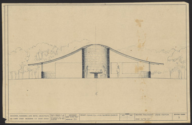 Robin Boyd Foundation
Drawing - External perspective, Tower Hill Lake Reserve Museum, Jun-61
... In 1961 Robin Boyd designed the Tower Hill Reserve Visitors Centre to fit naturally within the surrounding terrain. The building’s shape reflects a volcanic cone. ...Robin Boyd Foundation 290 Walsh Street South Yarra melbourne In 1961 Robin Boyd designed the Tower Hill Reserve Visitors Centre to fit naturally within the surrounding terrain. The building’s shape reflects a volcanic cone. ...In 1961 Robin Boyd designed the Tower Hill Reserve Visitors Centre to fit naturally within the surrounding terrain. The building’s shape reflects a volcanic cone. The windows allow a 360-degree view of the park. The Centre opened just after Robin Boyd’s death in October 1971.Project: Tower Hill Lake Reserve Museum drawn by Robin Boyd of Grounds, Romberg & Boyd. Drawing no 3. Watercolour on dyelinetower hill, robin boyd, ohm2022, ohm2022_15 -
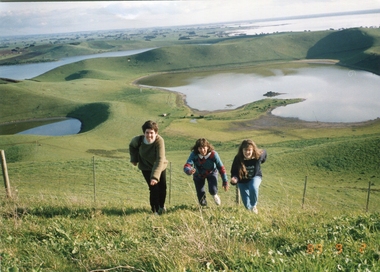 Ballarat Heritage Services
Photograph - Photograph - Colour, Kathleen Gervasoni, Red Rock, Alvie, 1989, 02/09/1989
... Red Rock, Alvie, near Colac, is a complex of approximately 30 volcanic eruption points and is the Southern most of a chain of three volcanoes, the others being Warrion Hill and Alvie Hill. ...Ballarat Heritage Services PO Box 2209 Bakery Hill Post Office goldfields Red Rock, Alvie, near Colac, is a complex of approximately 30 volcanic eruption points and is the Southern most of a chain of three volcanoes, the others being Warrion Hill and Alvie Hill. ...Red Rock, Alvie, near Colac, is a complex of approximately 30 volcanic eruption points and is the Southern most of a chain of three volcanoes, the others being Warrion Hill and Alvie Hill. It is arguably the youngest eruption point in Victoria at around 8000 years, especially since the age of Mt Napier has been progressively pushed back. The highest point (on the Northern side) has many interesting features, including some awesome spatter ramparts. Driving around the rim to the south, you can also see layered tuff. There are some good views out to Lake Corangamite and the lava flows (probably from Warrion Hill) can be seen where they have entered the lake. Most of Red Rock is in private land, with two lookout points with some interpretive information. The water depicted in this photograph is not evident in 2019. Type: Volcanic Complex Location: South of Alvie, Victoria Last Eruption: 8000 years ago Access: Mostly private land, but there is an access road and some interpretive signage Visited: Visited Colour photograph of sisters Clare Gervasoni (left), Ann Gervasoni (centre) and Lisa Gervasoni and Red Rock, Alvie clare gervasoni, lisa gervasoni, ann gervasoni, red rock alvie -
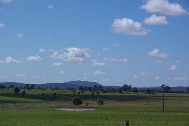 Ballarat Heritage Services
Photograph - Photograph - Colour, Clare Gervasoni, Mount Franklin from Smeaton, 22/09/2013
... Ballarat Heritage Services PO Box 2209 Bakery Hill Post Office goldfields mount franklin volcano Smeaton Lalgambook An extinct volcanic mountain known as Mount Franklin from Smeaton, Victoria Mount Franklin from Smeaton Photograph Photograph - Colour Clare Gervasoni ...An extinct volcanic mountain known as Mount Franklin from Smeaton, Victoriamount franklin, volcano, smeaton, lalgambook -
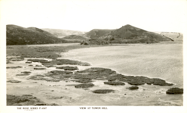 Ballarat Heritage Services
Photograph - Photograph - Black and White, Tower Hill, Victoria
... Tower Hill is a volcanic formation believed to have erupted about 32,000 years ago. ...Ballarat Heritage Services PO Box 2209 Bakery Hill Post Office goldfields Tower Hill is a volcanic formation believed to have erupted about 32,000 years ago. ...Tower Hill is a volcanic formation believed to have erupted about 32,000 years ago. Its formation is known as a "nested maar" and it is the largest example of its type in Victoria. During formation, molten lava pushed its way up through the Earth’s crust and encountered a layer of water-bearing rock. Violent explosions followed creating a shallow crater which later filled with water to form the lake. Further eruptions occurred in the centre of this crater, creating the islands and cone shaped hills. In 1892 Tower Hill became Victoria’s first National Park. In 1961, Tower Hill became a State Game Reserve under the then Fisheries and Wildlife Department and a major re-vegetation program began. (https://www.towerhill.org.au/index.php/about-reserve/history, accessed 23 December 2019)Black and white photograph of Tower Hill devoid of trees.tower hill, crossley, volcano -
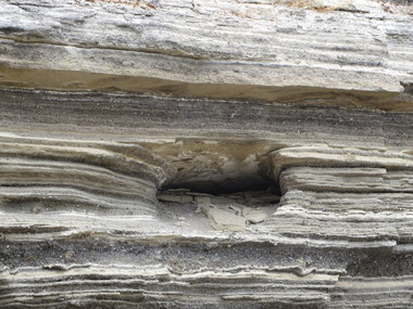 Ballarat Heritage Services
Photograph - Photograph - Colour, Ash Layers at Tower Hill, Victoria, 2015, 25/12/2015
... hill...volcanic ash...Colour photographs of the volcanic ash layers at Tower Hill....Ballarat Heritage Services PO Box 2209 Bakery Hill Post Office goldfields tower hill volcanic ash ash layers Colour photographs of the volcanic ash layers at Tower Hill. ...Colour photographs of the volcanic ash layers at Tower Hill.tower hill, volcanic ash, ash layers -
 Ballarat Heritage Services
Photograph - Postcard, Wombat Hill Gardens, Daylesford
... The Daylesford Botanic Gardens are of aesthetic significance as a rare example of a botanic garden spectacularly sited on an extinct volcanic cone which allows a panoramic view, aided by the 1938 Pioneers’ Memorial Tower, as well as vistas within and out of the gardens and from the township to the gardens. As the most prominent local landmark, the Garden’s vertical dominance in the landscape provides a dark contrast to the elms avenues, oaks and other deciduous species. (Heritage Victoria Register, ) Wombat Hill ...The Daylesford Botanic Gardens are of historic, scientific (botanic), and aesthetic significance to the State of Victoria. The Daylesford Botanic Gardens are historically significant as a fine example of a regional botanic garden demonstrating the typical characteristics of a carriage drive, informal park layout, decorative structures and works such as the memorial tower, conservatory, rotunda, cascade and fernery, which contrasts with the open lawns planted with specimen trees, areas of intensive horticultural interest and close proximity to a township developed during the mid to late nineteenth century. The Daylesford Botanic Gardens are historically significant for the design input by noted landscape designer William Sangster, and for the survival of his 1884 plan, which is a rare example of a plan from this prolific garden designer. The Daylesford Botanic Gardens are of scientific (botanic) significance for the extensive conifer collection and cool climate plants. The Gardens contain an outstanding collection of conifers and other mature trees, many of which were donated by renowned botanist Ferdinand von Mueller. Significant trees include Pinus ponderosa (Western Yellow Pine), Pinus coulteri (Big Cone Pine), twoAbies nordmanniana (Caucasian Fir), Abies pinsapo, (Spanish Fir) and a Cedrus atlantica f. glauca(Blue Atlas Cedar), Pinus wallichiana (Bhutan Pine), Pinus pinaster (Maritime Pine), Sequoiadendron giganteum (Giant Redwood), (Monkey Puzzle) and Aesculus hippocastanum (Horse Chestnut), many the largest or finest examples in Victoria. Other outstanding trees include a Tilia cordata (Small-leaved European Linden), a row of Cupressus lusitanica (Mexican cypress), a Quercus robur (English Oak) planted in 1863, avenues of Dutch Elms and a rare Quercus leucotrichophora (Himalayan Oak). The Daylesford Botanic Gardens are of aesthetic significance as a rare example of a botanic garden spectacularly sited on an extinct volcanic cone which allows a panoramic view, aided by the 1938 Pioneers’ Memorial Tower, as well as vistas within and out of the gardens and from the township to the gardens. As the most prominent local landmark, the Garden’s vertical dominance in the landscape provides a dark contrast to the elms avenues, oaks and other deciduous species. (Heritage Victoria Register, )Black and white postcard of Wombat Hill Botanical Gardens, Daylesford.wombat hill botanical gardens, daylesford, gardener, wombat hill botanic gardens